proposed variation no. 1 aa screening
TRANSCRIPT

Includes Ordnance Survey Ireland data reproduced under OSi licence number 2003/07CCMA/Kilkenny County Council Unauthorised reproduction infringes Ordnance Survey Ireland and Government of Ireland copyright. © Ordnance Survey Ireland
APPROPRIATE ASSESSMENT SCREENING REPORT
IN SUPPORT OF THE
APPROPRIATE ASSESSMENT OF
Proposed Variation No. 1 to the Kilkenny City and Environs Development
Plan 2014 - 2020
IN ACCORDANCE WITH THE REQUIREMENTS OF ARTICLE 6(3) OF THE EU HABITATS DIRECTIVE
for: Kilkenny County Council
County Hall
Johns Street
Kilkenny
by: CAAS Ltd. 2nd Floor, The Courtyard
25 Great Strand Street
Dublin 1
JUNE 2015

Appropriate Assessment Screening for Proposed Variation to the Kilkenny City and Environs Development Plan 2014 - 2020
CAAS for Kilkenny County Council i
Table of Contents
Section 1 Introduction ......................................................................................... 2
1.1 Background .................................................................................................................. 2
1.2 Legislative Context ....................................................................................................... 2
1.3 Stages of Appropriate Assessment ................................................................................. 3
Section 2 Stage 1 Screening ................................................................................ 4
2.1 Description of the Proposed Variation ............................................................................. 4
2.2 European sites in and within 15 km of the Plan Area ........................................................ 5
2.3 Assessment Criteria .................................................................................................... 11
2.4 Other Plans and Programmes ...................................................................................... 13
Section 3 Conclusions ........................................................................................ 16
3.1 Conclusion ................................................................................................................. 16
List of Tables Table 2-1 European sites within 15 km of lands referred to by the Proposed Variation to the KCEDP .. 7
Table 2-2: Summary of the individual elements of the variation and the potential for these to give rise to impacts on European sites. .................................................................................................... 11
Table 2-3 Screening of European sites ........................................................................................ 13
Table 2-4 Plans & Programmes Likely to Cause In-Combination Effects .......................................... 13
List of Figures Figure 2.1: Location of European Sites in Relation to the Kilkenny City and Environs Development Plan 2014 – 2020. .............................................................................................................................. 8
Figure 2.2 Map showing the extent of the Masterplan Area in relation to the River Barrow and River Nore cSAC. ................................................................................................................................. 9
Figure 2.3 Map showing the extent of the Masterplan Area in relation to the River Nore SPA. .......... 10
List of Appendices Appendix I: Kilkenny City and Environs Development 2014-2020 Environmental Provisions (Appendix A of Draft Masterplan for Abbey Creative Quarter Kilkenny).
Appendix II: Mitigation measures incorporated into the text of the Masterplan as a result of the Appropriate Assessment process.

Appropriate Assessment Screening for Proposed Variation to the Kilkenny City and Environs Development Plan 2014 - 2020
CAAS for Kilkenny County Council 2
Section 1 Introduction
1.1 Background
This is the Appropriate Assessment Screening Report in support of the Appropriate Assessment of the Proposed Variation to the Kilkenny City and Environs Development Plan 2014 – 2020 (KCEDP) in accordance with the requirements of Article 6(3) of the EU Habitats Directive1. This report is divided into the following three sections:
Section 1 Introduction Section 2 Stage 1 Screening Section 3 Conclusions
1.2 Legislative Context
The Council Directive 92/43/EEC on the Conservation of Natural Habitats and of Wild Fauna and Flora, better known as “The Habitats Directive”, provides legal protection for habitats and species of European importance. Articles 3 to 9 provide the legislative means to protect habitats and species of Community interest through the establishment and conservation of an EU-wide network of Sites known as Natura 2000. These are candidate Special Areas of Conservation (cSACs) designated under the Habitats Directive and Special Protection Areas (SPAs) designated under the Conservation of Wild Birds Directive (Directive 2009/147/EC - codified version of Directive 79/409/EEC as amended), hereafter referred to as European sites.
Articles 6(3) and 6(4) of the Habitats Directive set out the decision-making tests for plans and projects likely to affect Natura 2000 sites (Annex 1.1). Article 6(3) establishes the requirement for Appropriate Assessment (AA):
“Any plan or project not directly connected with or necessary to the management of the [Natura 2000] site but likely to have a significant effect thereon, either individually or in combination with other plans or projects, shall be subjected to appropriate assessment of its implications for the site in view of the site’s conservation objectives. In light of the conclusions of the assessment of the implications for the site and subject to the provisions of paragraph 4, the competent national authorities shall agree to the plan or project only after having ascertained that it will not adversely affect the integrity of the site concerned and, if appropriate, after having obtained the opinion of the general public
If, in spite of a negative assessment of the implications for the [Natura 2000] site and in the absence of alternative solutions, a plan or project must nevertheless be carried out for imperative reasons of overriding public interest, including those of a social or economic nature, Member States shall take all compensatory measures necessary to ensure that the overall coherence of Natura 2000 is protected. It shall inform the Commission of the compensatory measures adopted.
Where the site concerned hosts a priority natural habitat type and/or a priority species the only considerations which may be raised are those relating to human health or public safety, to beneficial consequences of primary importance for the environment or, further to an opinion from the Commission, to other imperative reasons of overriding public interest.”
These requirements are implemented in the Republic of Ireland by the European Communities (Birds and Natural Habitats) Regulations 2011. These Regulations consolidate the European Communities
1 Directive 92/43/EEC
Appropriate Assessment Screening for Proposed Variation to the Kilkenny City and Environs Development Plan 2014 - 2020
CAAS for Kilkenny County Council 3
(Natural Habitats) Regulations 1997 to 2005 and the European Communities (Birds and Natural Habitats) (Control of Recreational Activities) Regulations 2010, as well as addressing transposition failures identified in judgments of the Court of Justice of the European Union (CJEU)2.
1.3 Stages of Appropriate Assessment
This Appropriate Assessment has been prepared in accordance with the following guidance:
Appropriate Assessment of Plans and Projects in Ireland. Guidance for Planning Authorities. Department of the Environment, Heritage and Local Government, 2010.
Assessment of plans and projects significantly affecting Natura 2000 sites: Methodological guidance on the provisions of Article 6(3) and (4) of the Habitats Directive 92/43/EEC, European Commission Environment DG, 2002.
Managing Natura 2000 sites: The Provisions of Article 6 of the Habitats Directive 92/43/EEC. European Commission, 2000.
AA comprises up to four successive stages:
Stage One: Screening The process which identifies the likely impacts upon a European Site of a project or plan, either alone or in combination with other projects or plans, and considers whether these impacts are likely to be significant.
Stage Two: Appropriate Assessment The consideration of the impact on the integrity of the European Site of the project or plan, either alone or in combination with other projects or plans, with respect to the Site’s structure and function and its conservation objectives. Additionally, where there are adverse impacts, an assessment of the potential mitigation of those impacts.
Stage Three: Assessment of Alternative Solutions The process which examines alternative ways of achieving the objectives of the project or plan that avoid adverse impacts on the integrity of the European Site.
Stage Four: Assessment where no alternative solutions exist and where adverse impacts remain
An assessment of compensatory measures where, in the light of an assessment of imperative reasons of overriding public interest (IROPI), it is deemed that the project or plan should proceed.
The Habitats Directive promotes a hierarchy of avoidance, mitigation and compensatory measures. First, the plan should aim to avoid any impacts on European Sites by identifying possible impacts early in the plan-making process and writing the plan in order to avoid such impacts. Second, mitigation measures should be applied, if necessary, during the AA process to the point where no adverse impacts on the Site(s) remain. If the plan is still likely to result in impacts on European Sites, and no further practicable mitigation is possible, then it must be rejected. If no alternative solutions are identified and the plan is required for imperative reasons of overriding public interest (IROPI test) under Article 6(4) of the Habitats Directive, then compensation measures are required for any remaining adverse effect.
In the case of this Appropriate Assessment Screening Report, it is found that the Proposed Variation only requires Stage 1 Screening.
2 Notably cases C-418/04 and C-183/05, in respect of failure to transpose elements of the Birds Directive and the Habitats Directive into Irish law.

Appropriate Assessment Screening for Proposed Variation to the Kilkenny City and Environs Development Plan 2014 - 2020
CAAS for Kilkenny County Council 4
Section 2 Stage 1 Screening
2.1 Description of the Proposed Variation
2.1.1 The Kilkenny City and Environs Development Plan 2014 - 2020
The Kilkenny City & Environs Development Plan 2014 2020 was prepared under the provisions of the ‐Planning and Development Acts 2000 2013 to develop and improve the City & Environs (hereafter ‐referred to as the City) in a sustainable manner. A separate Development Plan covers the wider Kilkenny County. The area to be included in this Plan includes four main neighbourhoods in the City; Eastern Environs, Loughboy, Western Environs, and Loughmacask. The Eastern Environs and Loughboy are largely built out. There are two large brownfield sites available for redevelopment in the city centre at present; the Smithwick’s site west of the River Nore, which was formerly a brewery, and the old mart site, east of the River Nore.
The Plan contents are best described through a list of the chapter headings:
1. Introduction
2. Demographic and Socio‐Economic Trends
3. Core Strategy
4. Economic Development
5. Housing and Community
6. Recreation, Tourism & the Arts
7. Heritage
8. Infrastructure
9. Renewable Energy Strategy
10. Transport
11. Requirements for Developments
As the Core Strategy included in Chapter 3 of the Plan outlines, the focus for new development will be in the neighbourhoods of Loughmacask and the Western Environs. The estimated population increase for the whole city and environs is 2,077. The main objectives and ethos of the Plan can be summarised in the Council’s Mission Statement (section 1.8) as follows: “Kilkenny Local Authorities aim to work in partnership with the people of Kilkenny and relevant agencies to deliver quality services and to promote sustainable economic, social and cultural development for current and future generations.” The Plan provides a land use framework for the sustainable development of Kilkenny City and Environs. The Plan sets the strategic context for any lower tier plans, such as Local Area ‐Plans to be prepared in the city. In its making, the Plan had regard to all relevant planning and environmental policy and legislation including European Union directives, Ministerial guidelines and other national, regional and county plans and policies.
The Plan sets the strategic context for any lower tier plans, such as Local Area Plans (LAPs) to be ‐prepared in the city. There is one LAP in place for Loughmacask, and two other LAPs for the Western Environs and the City Centre have been incorporated into the Plan.
2.1.2 Proposed Variation to the Plan
The proposed variation to the KCEDP consists of the following text (1-9 below) in order to establish high level principles for the area covered by the Abbey Creative Quarter Masterplan, issued in June 2015. The Abbey Creative Quarter Masterplan has also undergone Appropriate Assessment (AA) in accordance with Article 6(3) of the habitats directive.

Appropriate Assessment Screening for Proposed Variation to the Kilkenny City and Environs Development Plan 2014 - 2020
CAAS for Kilkenny County Council 5
1. To provide for a linear park along the western bank of the River Nore connecting to the existing River Nore linear park north of Green’s Bridge and the existing River Nore linear park south of the Masterplan area (Canal Walk) (as indicated on Fig 3.4) subject to compliance with the Habitats and Birds Directives and the provisions of the Abbey Creative Quarter Masterplan.
2. To provide for an urban park in the vicinity of St. Francis Abbey (National Monument) incorporating Evan’s Turret and St. Francis’ Well taking into account the recommendations of the archaeological strategy developed in the preparation of the Abbey Creative Quarter Masterplan (as indicated on fig 3.4) and subject to compliance with the Habitats and Birds Directives and the provisions of the Abbey Creative Quarter Masterplan.
3. To prepare a Heritage Conservation Plan for St. Francis Abbey, Evans’ Turret and St. Francis’ Well in the context of the existing City Wall conservation plan in conjunction with the Heritage Council, the Office of Public Works, the National Monuments Service, the Department of Arts, Heritage and the Gaeltacht and other relevant stakeholders.
4. To prepare urban design criteria and recommendations and archaeological recommendations for the implementation of the Abbey Creative Quarter Masterplan.
5. To finalise and adopt the Abbey Creative Quarter Masterplan and to incorporate it into the Kilkenny City & Environs Development Plan 2014-2020.
6. To develop a low carbon energy strategy for the masterplan area and advance the provision of near zero energy buildings on site.
7. To provide for park and walk facilities for car and bus/coach parking at a site or sites in close proximity to the Abbey Creative Quarter Masterplan area to service both the masterplan area and the city centre generally.
8. To provide for housing within the masterplan in the area north of the Central Access Scheme as identified on fig 3.4.
9. To provide for an urban street of pedestrian and cyclist priority between the Central Access Scheme and Bateman Quay crossing the River Breagagh at the existing bridge crossing. To provide for traffic management measures on the street such as to inhibit the flow of through traffic and heavy goods vehicles.
2.1.3 Environmental Protection Objectives
Both the KCEDP and the Abbey Creative Quarter Masterplan have been subject to AA during their development. The Appropriate Assessment process has informed the contents of these plans during their development. The relevant provisions of the KCEDP are presented in Appendix I of this report.
In addition to proposed changes to text within the plan, the AA has also influenced the content of mapping and figures presented within the Masterplan document. Measures that have been incorporated into the Abbey Creative Quarter Masterplan to ensure protection of European sites are presented in Appendix II of this report.
2.2 European sites in and within 15 km of the Plan Area
2.2.1 cSACs and SPAs
This section of the screening process describes the European sites within 15 km of the KCEDP Plan Area. A distance of 15 km is currently recommended in the DoE document Guidance for Planning Authorities3 and as a precautionary measure, to ensure that all potentially affected European sites are included in the screening process. A map indicating the locations of the sites in relation to the proposed variation to the KCEDP Plan Area is presented in Figure 2.1. Table 2-1below lists the European sites that occur within 15 km of the lands referred to by the proposed variation to the KCEDP. The location of the Masterplan Area (the Abbey Quarter) in relation to European sites is illustrated in Figure 2.2 and Figure 2.3 below.
3 DoEHLG (2010). Appropriate Assessment of Plans and Projects in Ireland. Guidance for Planning Authorities.

Appropriate Assessment Screening for Proposed Variation to the Kilkenny City and Environs Development Plan 2014 - 2020
CAAS for Kilkenny County Council 6
There has been three European sites identified within 15 km of the KCEDP; the River Barrow and River Nore cSAC (NPWS Site Code: 002162), River Nore SPA (NPWS Site Code: 004233), and Thomastown Quarry cSAC (NPWS Site Code: 002252). Two of these sites, River Nore and River Barrow cSAC and the River Nore SPA occur within the Plan Area. The River Breagagh (tributary of the River Nore) flows west to east through the Masterplan Area, discharging into the River Nore to the east (see Figure 2.2 and Figure 2.3 below).
The qualifying features for each site have been obtained through a review of information pertaining to each site available from the NPWS website.
Information regarding the main threats to European sites was derived from a variety of sources:
Ireland’s Article 17 Report to the European Commission “Status of EU Protected Habitats and Species in Ireland” (NPWS, 2013).
Site Synopses.
NATURA 2000 Standard Data Forms.
Since the conservation management objectives for the European sites focus on maintaining the favourable conservation status of the qualifying interests of each site, the Screening process concentrated on assessing the potential implications of the Proposed Variation against the qualifying interests of each site.

Appropriate Assessment Screening for Proposed Variation to the Kilkenny City and Environs Development Plan 2014 - 2020
CAAS for Kilkenny County Council 7
Table 2-1 European sites within 15 km of lands referred to by the Proposed Variation to the KCEDP
Site Code
Site Name Qualifying Feature Threats to Site Integrity
002162 River Barrow and River Nore cSAC
Annex I Habitats [1130] Estuaries [1140] Tidal Mudflats and Sandflats [1310] Salicornia mud [1320] Spartina swards [1330] Atlantic salt meadows [1410] Mediterranean salt meadows [3260] Floating River Vegetation [4030] Dry Heath [6430] Hydrophilous Tall Herb [7220] Petrifying Springs [91A0] Old Oak Woodlands [91E0] Residual Alluvial Forests Annex II Species [1016] Desmoulin’s Whorlsnail (Vertigo moulinsiana ) [1029] Freshwater pearl mussel (Margaritifera margaritifera) [1092] White-clawed crayfish (Austropotamobius pallipes) [1095] Sea lamprey (Petromyzon marinus) [1096] Brook lamprey (Lampetra planeri) [1099] River lamprey (Lampetra fluviatilis) [1102] Allis shad (Alosa alosa) [1103] Twaite shad (Alosa fallax fallax) [1106] Salmon (Salmo salar) [1421] Killarney fern (Trichomanes speciosum) [1990] Pearl mussel (Margaritifera durrovensis) [1355] Otter (Lutra lutra)
The principle threats to the River Barrow and River Nore cSAC are pollution caused by increased fertiliser application, sewage and industrial waste. Species for which the site is designated are highly susceptible to siltation and pollution of water courses. Proposed developments in the vicinity of the cSAC may give rise to siltation and run-off of pollutants. The river has also been designated for its population of otter, a species vulnerable to the felling of mixed wood and scrub. Otters may become displaced due to disturbance in proximity to the cSAC.
004233 River Nore SPA [A229] Kingfisher (Alcedo atthis) Threats ranked as having a medium negative impact have been recorded for this site; landfill, land reclamation, drying out, and pressures from port areas. The site is also susceptible to alterations in hydrology and disturbance. The site is of national importance for its Kingfisher population. Kingfisher are likely to be vulnerable to disturbance effects of development works in proximity of the site. Any loss or disturbance to bankside habitat could also impact on the breeding population.
002252 Thomastown Quarry cSAC [7220] Petrifying springs A proposed road scheme adjacent to this site poses the threat of direct habitat loss and indirect hydrological impacts. No other threats are known to this site.

Appropriate Assessment Screening for Proposed Variation to the Kilkenny City and Environs Development Plan 2014 - 2020
CAAS for Kilkenny County Council 8
Figure 2.1: Location of European Sites in Relation to the Kilkenny City and Environs Development Plan 2014 – 2020.

Appropriate Assessment Screening for Proposed Variation to the Kilkenny City and Environs Development Plan 2014 - 2020
CAAS for Kilkenny County Council 9
Figure 2.2 Map showing the extent of the Masterplan Area in relation to the River Barrow and River Nore cSAC. 4
4 Mapping of the cSAC boundary by NPWS was undertaken using OSI six inch mapping as a basemap and therefore does not overlay correctly with more recent mapping. The true boundary of the cSAC is likely to match the more recently mapped SPA boundary as shown in Figure 2.3 below and therefore can be assumed to directly border the eastern boundary of the Masterplan Area.

Appropriate Assessment Screening for Proposed Variation to the Kilkenny City and Environs Development Plan 2014 - 2020
CAAS for Kilkenny County Council 10
Figure 2.3 Map showing the extent of the Masterplan Area in relation to the River Nore SPA.

Appropriate Assessment Screening for Proposed Variation to the Kilkenny City and Environs Developement Plan 2014 - 2020
CAAS for Kilkenny County Council 11
2.3 Assessment Criteria
2.3.1 Is the Plan Necessary to the Management of European Sites?
Under the Habitats Directive, plans that are directly connected with or necessary to the management of a European site do not require AA. For this exception to apply, management is required to be interpreted narrowly as nature conservation management in the sense of Article 6(1) of the Habitats Directive. This refers to specific measures to address the ecological requirements of annexed habitats and species (and their habitats) present on a site(s). The relationship should be shown to be direct and not a by-product of the plan, even if this might result in positive or beneficial effects for a site(s).
The Proposed Variation to the KCEDP 2014 - 2020 includes measures that will benefit the protection of European designated sites however its primary purpose is not the nature conservation management of the sites, but to provide for development. Therefore, the Proposed Variation to the KCEDP is not considered by the Habitats Directive to be directly connected with or necessary to the management of European designated sites.
2.3.2 Elements of the Proposed Variation with Potential to Give Rise to Significant Effects
The Proposed Variation incorporates high level principles in the KCEDP for the area covered by the Abbey Creative Quarter Masterplan, issued in June 2015. There are nine additions of text being proposed to the KCEDP as part of the Proposed Variation. The potential for each of these textual changes to impact on European sites in the surroundings is presented in Table 2-2.
In summary it is concluded that sufficient controls and measures are incorporated into the KCEDP (see Appendix I) and the Masterplan (See Appendix II) to ensure that adverse impacts on European sites will not occur due to the implementation of the Proposed Variation.
Table 2-2: Summary of the individual elements of the variation and the potential for these to give rise to impacts on European sites.
Variation text Potential significant effects on European Sites
1. To provide for a linear park along the western bank of the River Nore connecting to the existing River Nore linear park north of Green's Bridge and the existing River Nore linear park south of the Masterplan area (Canal Walk) (as indicated on Fig 3.4) subject to compliance with the Habitats and Birds Directives and the provisions of the Abbey Creative Quarter Masterplan.
The site of the linear park is adjacent to the River Barrow and River Nore cSAC and the River Nore SPA. Mitigation has been incorporated into the Masterplan text and associated figures to avoid potential significant effects due to the development of the linear park. Further provisions are included within the existing KCEDP to ensure that any development will comply with appropriate environmental protection and sustainable development requirements.
2. To provide for an urban park in the vicinity of St. Francis Abbey (National Monument) incorporating Evan's Turret and St. Francis' Well taking into account the recommendations of the archaeological strategy developed in the preparation of the Abbey Creative Quarter Masterplan (as indicated on fig 3.4) and subject to compliance with the Habitats and Birds Directives and the provisions of the Abbey Creative Quarter
Mitigation has been incorporated into the Masterplan text and associated figures to avoid potential significant effects due to developments within the site of the Abbey Quarter.

Appropriate Assessment Screening for Proposed Variation to the Kilkenny City and Environs Developement Plan 2014 - 2020
CAAS for Kilkenny County Council 12
Variation text Potential significant effects on European Sites
Masterplan.
3. To prepare a Heritage Conservation Plan for St. Francis Abbey, Evans' Turret and St. Francis' Well in the context of the existing City Wall conservation plan in conjunction with the Heritage Council, the Office of Public Works, the National Monuments Service, the Department of Arts, Heritage and the Gaeltacht and other relevant stakeholders.
No potential significant effects on European sites are foreseen.
4. To prepare urban design criteria and recommendations and archaeological recommendations for the implementation of the Abbey Creative Quarter Masterplan.
No potential significant effects on European sites are foreseen.
5. To finalise and adopt the Abbey Creative Quarter Masterplan and to incorporate it into the Kilkenny City & Environs Development Plan 2014-2020.
The AA process has informed the content of the Masterplan. The Natura Impact Report prepared on the Masterplan has concluded that the implementation of the pan will not have a significant effect on the integrity of the Natura 2000 network of sites.
6. To develop a low carbon energy strategy for the masterplan area and advance the provision of near zero energy buildings on site.
No potential significant effects on European sites are foreseen.
7. To provide for park and walk facilities for car and bus/coach parking at a site or sites in close proximity to the Abbey Creative Quarter Masterplan area to service both the masterplan area and the city centre generally.
The development of any site for such use will undergo environmental assessment and will be required to be screened for Appropriate Assessment. Such facilities will be located in a site removed from European sites. Sufficient controls are in place to ensure that such a development will not impact on European sites.
8. To provide for housing within the masterplan in the area north of the Central Access Scheme as identified on fig 3.4.
The AA process has informed the content of the Masterplan. The Natura Impact Report prepared on the Masterplan has concluded that the implementation of the pan will not have a significant adverse effect on the integrity of the Natura 2000 network of sites.
9. To provide for an urban street of pedestrian and cyclist priority between the Central Access Scheme and Bateman Quay crossing the River Breagagh at the existing bridge crossing. To provide for traffic management measures on the street such as to inhibit the flow of through traffic and heavy goods vehicles.
This provision has been included as a provision of the Masterplan and therefore was considered by the AA undertaken on the Masterplan. The AA process has informed the content of the Masterplan. The Natura Impact Report prepared on the Masterplan has concluded that the implementation of the pan will not adversely affect the integrity of the Natura 2000 network of sites.

Appropriate Assessment Screening for Proposed Variation to the Kilkenny City and Environs Developement Plan 2014 - 2020
CAAS for Kilkenny County Council 13
2.3.3 Identification of Potential Likely Significant Effects
This section documents the final stage of the screening process and determine the likelihood of significant adverse impacts to arise on individual European sites. It has used the information collected on the sensitivity of each European site and describes any likely significant effects of the implementation of the Proposed Variation.
In determining the potential for significant effects, a number of factors have been taken into account. Firstly, the sensitivity and reported threats to the European site. Secondly, the individual elements of the Proposed Variation and the potential effect they may cause on the site were considered.
The outcome of this screening is presented in Table 2-3 below. In summary, taking into consideration the provisions of the Masterplan document together with the overarching provisions contained in the KCEDP, there is no likelihood of significant effects on any of the three relevant European sites and therefore there is no need to advance to Stage II Appropriate Assessment.
Table 2-3 Screening of European sites
Site Name Potential for adverse impacts Stage 2 AA required
River Barrow and River Nore cSAC No. It is considered that sufficient measures and controls are incorporated into the Masterplan and the KCEDP to ensure that the site will not be adversely impacted by the implementation of the proposed Variation.
No
River Nore SPA No. It is considered that sufficient measures and controls are incorporated into the Masterplan and the KCEDP to ensure that the site will not be adversely impacted by the implementation of the proposed Variation.
No
Thomastown Quarry cSAC No - considering the nature of the Proposed Variation and the distance of the proposed works from this site, no impacts are foreseen.
No
2.4 Other Plans and Programmes
Article 6(3) of the Habitats Directive requires an assessment of a plan or project to consider other plans or programmes that might, in combinations with the plan or project, have the potential to adversely impact upon European sites. Table 2-4 below lists the plans or programmes that may interact with the Proposed Variation to cause in-combination effects to European sites. The plans or programmes are listed according to a four tier spatial hierarchy: International; National; Regional; and Local.
Given the uncertainties that exist with regard to the scale and location of developments facilitated by the Proposed Variation, it is recognised that the identification of cumulative impacts is limited and that the assessment of in-combination effects will need to be undertaken in a more comprehensive manner at the project-level.
Table 2-4 Plans & Programmes Likely to Cause In-Combination Effects
Directive Purpose Interactions resulting in Cumulative Impacts International EU Water Framework Directive (2000/60/EC)
Objectives seek to maintain and enhance the quality of all surface waters in the EU.
No risk of likely significant in-combination effects will result as the primary purpose of the Directive is to improve environmental quality.
EU Freshwater Fish Objectives seek to protect those fresh water No risk of likely significant in-combination effects will
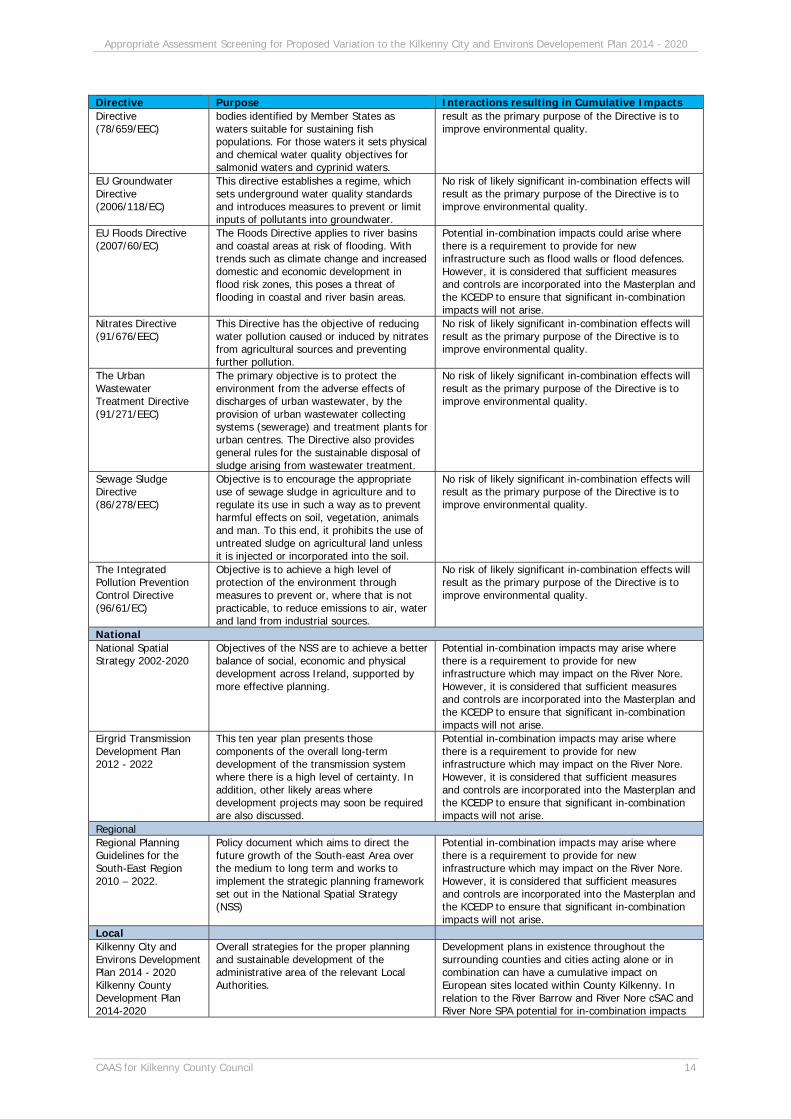
Appropriate Assessment Screening for Proposed Variation to the Kilkenny City and Environs Developement Plan 2014 - 2020
CAAS for Kilkenny County Council 14
Directive Purpose Interactions resulting in Cumulative Impacts Directive (78/659/EEC)
bodies identified by Member States as waters suitable for sustaining fish populations. For those waters it sets physical and chemical water quality objectives for salmonid waters and cyprinid waters.
result as the primary purpose of the Directive is to improve environmental quality.
EU Groundwater Directive (2006/118/EC)
This directive establishes a regime, which sets underground water quality standards and introduces measures to prevent or limit inputs of pollutants into groundwater.
No risk of likely significant in-combination effects will result as the primary purpose of the Directive is to improve environmental quality.
EU Floods Directive (2007/60/EC)
The Floods Directive applies to river basins and coastal areas at risk of flooding. With trends such as climate change and increased domestic and economic development in flood risk zones, this poses a threat of flooding in coastal and river basin areas.
Potential in-combination impacts could arise where there is a requirement to provide for new infrastructure such as flood walls or flood defences. However, it is considered that sufficient measures and controls are incorporated into the Masterplan and the KCEDP to ensure that significant in-combination impacts will not arise.
Nitrates Directive (91/676/EEC)
This Directive has the objective of reducing water pollution caused or induced by nitrates from agricultural sources and preventing further pollution.
No risk of likely significant in-combination effects will result as the primary purpose of the Directive is to improve environmental quality.
The Urban Wastewater Treatment Directive (91/271/EEC)
The primary objective is to protect the environment from the adverse effects of discharges of urban wastewater, by the provision of urban wastewater collecting systems (sewerage) and treatment plants for urban centres. The Directive also provides general rules for the sustainable disposal of sludge arising from wastewater treatment.
No risk of likely significant in-combination effects will result as the primary purpose of the Directive is to improve environmental quality.
Sewage Sludge Directive (86/278/EEC)
Objective is to encourage the appropriate use of sewage sludge in agriculture and to regulate its use in such a way as to prevent harmful effects on soil, vegetation, animals and man. To this end, it prohibits the use of untreated sludge on agricultural land unless it is injected or incorporated into the soil.
No risk of likely significant in-combination effects will result as the primary purpose of the Directive is to improve environmental quality.
The Integrated Pollution Prevention Control Directive (96/61/EC)
Objective is to achieve a high level of protection of the environment through measures to prevent or, where that is not practicable, to reduce emissions to air, water and land from industrial sources.
No risk of likely significant in-combination effects will result as the primary purpose of the Directive is to improve environmental quality.
National National Spatial Strategy 2002-2020
Objectives of the NSS are to achieve a better balance of social, economic and physical development across Ireland, supported by more effective planning.
Potential in-combination impacts may arise where there is a requirement to provide for new infrastructure which may impact on the River Nore. However, it is considered that sufficient measures and controls are incorporated into the Masterplan and the KCEDP to ensure that significant in-combination impacts will not arise.
Eirgrid Transmission Development Plan 2012 - 2022
This ten year plan presents those components of the overall long-term development of the transmission system where there is a high level of certainty. In addition, other likely areas where development projects may soon be required are also discussed.
Potential in-combination impacts may arise where there is a requirement to provide for new infrastructure which may impact on the River Nore. However, it is considered that sufficient measures and controls are incorporated into the Masterplan and the KCEDP to ensure that significant in-combination impacts will not arise.
Regional Regional Planning Guidelines for the South-East Region 2010 – 2022.
Policy document which aims to direct the future growth of the South-east Area over the medium to long term and works to implement the strategic planning framework set out in the National Spatial Strategy (NSS)
Potential in-combination impacts may arise where there is a requirement to provide for new infrastructure which may impact on the River Nore. However, it is considered that sufficient measures and controls are incorporated into the Masterplan and the KCEDP to ensure that significant in-combination impacts will not arise.
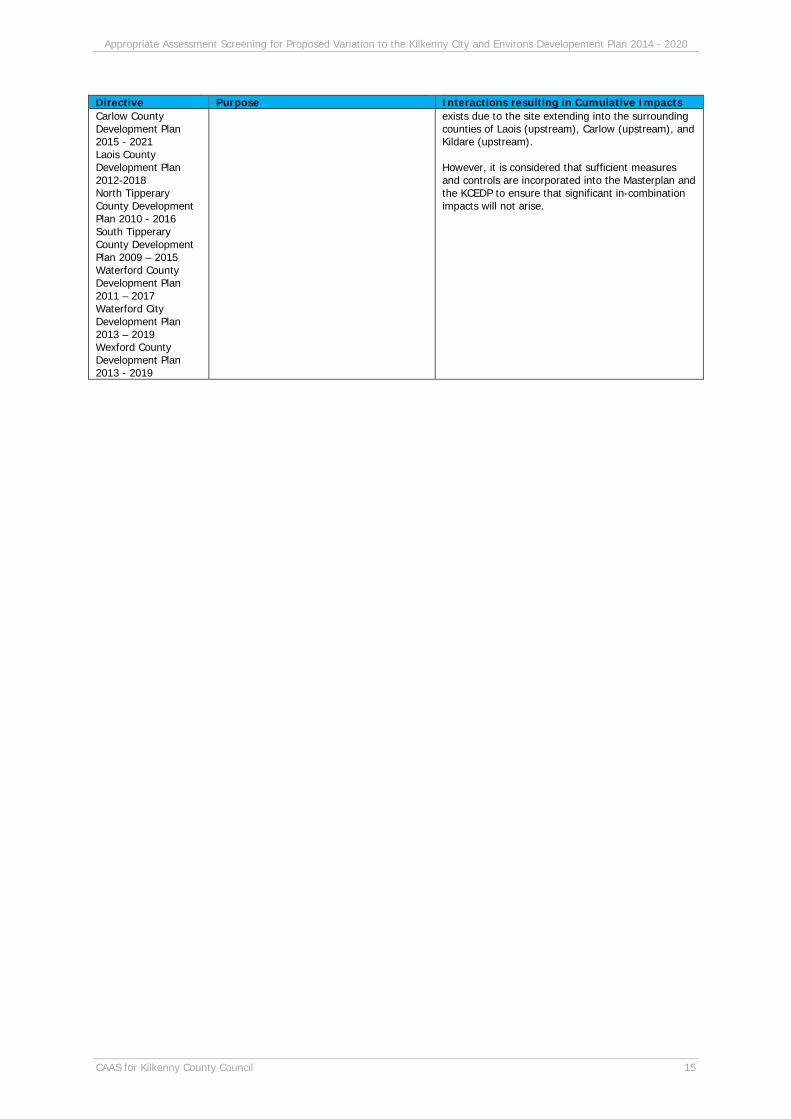
Local Kilkenny City and Environs Development Plan 2014 - 2020 Kilkenny County Development Plan 2014-2020
Overall strategies for the proper planning and sustainable development of the administrative area of the relevant Local Authorities.
Development plans in existence throughout the surrounding counties and cities acting alone or in combination can have a cumulative impact on European sites located within County Kilkenny. In relation to the River Barrow and River Nore cSAC and River Nore SPA potential for in-combination impacts
Appropriate Assessment Screening for Proposed Variation to the Kilkenny City and Environs Developement Plan 2014 - 2020
CAAS for Kilkenny County Council 15
Directive Purpose Interactions resulting in Cumulative Impacts Carlow County Development Plan 2015 - 2021 Laois County Development Plan 2012-2018 North Tipperary County Development Plan 2010 - 2016 South Tipperary County Development Plan 2009 – 2015 Waterford County Development Plan 2011 – 2017 Waterford City Development Plan 2013 – 2019 Wexford County Development Plan 2013 - 2019
exists due to the site extending into the surrounding counties of Laois (upstream), Carlow (upstream), and Kildare (upstream). However, it is considered that sufficient measures and controls are incorporated into the Masterplan and the KCEDP to ensure that significant in-combination impacts will not arise.
Appropriate Assessment Screening for Proposed Variation to the Kilkenny City and Environs Developement Plan 2014 - 2020
CAAS for Kilkenny County Council 16
Section 3 Conclusions
3.1 Conclusion
The requirement for a Stage 2 AA would arise if the Proposed Variation to the KCEDP were likely to have significant effects on a Natura 2000 site. This screening report evaluates the Proposed Variation to see if it needs to be the subject of a Stage 2 AA. It finds that the Proposed Variation to the KCEDP has been formulated to ensure that uses, developments and effects arising from permissions based upon the Variation (either individually or in combination with other plans or projects) shall not give rise to significant effects on the integrity of any Natura 2000 sites5. Therefore, in accordance with the Methodological guidance on the provision of Article 6(3) and (4) of the Habitats Directive 92/43/EEC, it is concluded that the Proposed Variation does not require any further assessment to demonstrate compliance with the Directive.
5 Except as provided for in Section 6(4) of the Habitats Directive, viz. There must be: (a) no alternative solution available; (b) imperative reasons of overriding public interest for the plan/programme/project to proceed; and (c) adequate compensatory measures in place.
Appropriate Assessment Screening for Proposed Variation to the Kilkenny City and Environs Developement Plan 2014 - 2020
CAAS for Kilkenny County Council 17
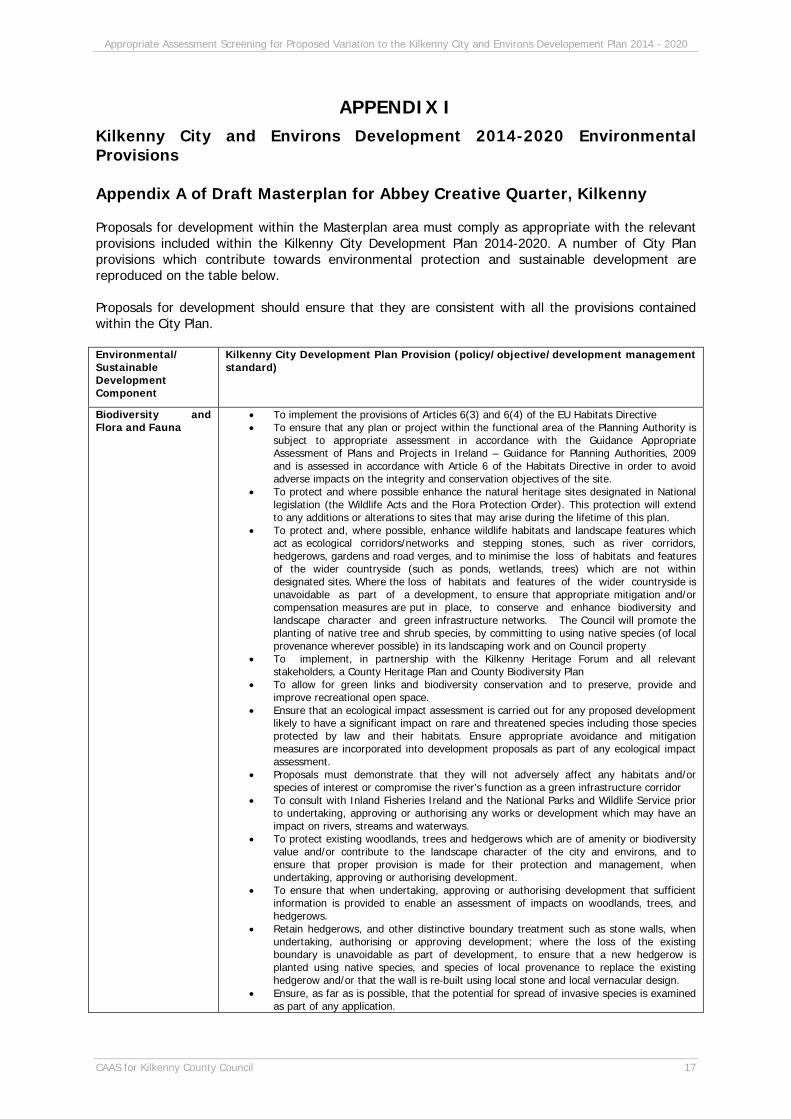
APPENDIX I Kilkenny City and Environs Development 2014-2020 Environmental Provisions Appendix A of Draft Masterplan for Abbey Creative Quarter, Kilkenny Proposals for development within the Masterplan area must comply as appropriate with the relevant provisions included within the Kilkenny City Development Plan 2014-2020. A number of City Plan provisions which contribute towards environmental protection and sustainable development are reproduced on the table below. Proposals for development should ensure that they are consistent with all the provisions contained within the City Plan. Environmental/ Sustainable Development Component
Kilkenny City Development Plan Provision (policy/objective/development management standard)
Biodiversity and Flora and Fauna
To implement the provisions of Articles 6(3) and 6(4) of the EU Habitats Directive To ensure that any plan or project within the functional area of the Planning Authority is
subject to appropriate assessment in accordance with the Guidance Appropriate Assessment of Plans and Projects in Ireland – Guidance for Planning Authorities, 2009 and is assessed in accordance with Article 6 of the Habitats Directive in order to avoid adverse impacts on the integrity and conservation objectives of the site.
To protect and where possible enhance the natural heritage sites designated in National legislation (the Wildlife Acts and the Flora Protection Order). This protection will extend to any additions or alterations to sites that may arise during the lifetime of this plan.
To protect and, where possible, enhance wildlife habitats and landscape features which act as ecological corridors/networks and stepping stones, such as river corridors, hedgerows, gardens and road verges, and to minimise the loss of habitats and features of the wider countryside (such as ponds, wetlands, trees) which are not within designated sites. Where the loss of habitats and features of the wider countryside is unavoidable as part of a development, to ensure that appropriate mitigation and/or compensation measures are put in place, to conserve and enhance biodiversity and landscape character and green infrastructure networks. The Council will promote the planting of native tree and shrub species, by committing to using native species (of local provenance wherever possible) in its landscaping work and on Council property
To implement, in partnership with the Kilkenny Heritage Forum and all relevant stakeholders, a County Heritage Plan and County Biodiversity Plan
To allow for green links and biodiversity conservation and to preserve, provide and improve recreational open space.
Ensure that an ecological impact assessment is carried out for any proposed development likely to have a significant impact on rare and threatened species including those species protected by law and their habitats. Ensure appropriate avoidance and mitigation measures are incorporated into development proposals as part of any ecological impact assessment.
Proposals must demonstrate that they will not adversely affect any habitats and/or species of interest or compromise the river’s function as a green infrastructure corridor
To consult with Inland Fisheries Ireland and the National Parks and Wildlife Service prior to undertaking, approving or authorising any works or development which may have an impact on rivers, streams and waterways.
To protect existing woodlands, trees and hedgerows which are of amenity or biodiversity value and/or contribute to the landscape character of the city and environs, and to ensure that proper provision is made for their protection and management, when undertaking, approving or authorising development.
To ensure that when undertaking, approving or authorising development that sufficient information is provided to enable an assessment of impacts on woodlands, trees, and hedgerows.
Retain hedgerows, and other distinctive boundary treatment such as stone walls, when undertaking, authorising or approving development; where the loss of the existing boundary is unavoidable as part of development, to ensure that a new hedgerow is planted using native species, and species of local provenance to replace the existing hedgerow and/or that the wall is re‐built using local stone and local vernacular design.
Ensure, as far as is possible, that the potential for spread of invasive species is examined as part of any application.

Appropriate Assessment Screening for Proposed Variation to the Kilkenny City and Environs Developement Plan 2014 - 2020
CAAS for Kilkenny County Council 18
To promote the use of native plants and seeds from indigenous seed sources in all landscape projects
To ensure the protection of the special character and setting of protected structures, ACAs and Recorded Monuments, and protected species when considering proposals for floodlighting.
See also measures on this table under Soil, Water, Flood Risk Management and Drainage and Water Services
Human Health and Provision Sustainable Planning and Development for People
To ensure the highest standards of environmental protection in the assessment of planning applications for all development proposals.
To integrate the planning and sustainable development of the county with regard to the social, community and cultural requirements of the county and its population.
See also measures on this table under Soil, Water, Water Services, Air and Climatic Factors and Flood Risk Management and Drainage
Soil/Geology Development will be encouraged and facilitated where it can be demonstrated that the development of the potentially contaminated site will result in a recreational and social benefit to the local area/community provided that identified remediation measures for the lands are carried out. The Council will require that a detailed investigation is carried out and appropriate measures are taken to ensure that the land is treated properly before development takes place.
The Council will consult the Geological Survey of Ireland when considering undertaking, approving or authorising developments which are likely to affect Geological Sites.
See also measures on this table under Biodiversity, Flora and Fauna, Water, Water Services and Flood Risk Management and Drainage
Water Meet in full the requirements of the E.U. Urban Waste Water Treatment and Water Framework Directives.
To have regard to the Groundwater Protection Scheme and the Water Services Acts 2007 & 2012 in decision‐making on the location, nature and control of developments and activities in order to protect groundwater.
To promote compliance with environmental standards and objectives established: for bodies of surface water, by the European Communities (Surface Waters) Regulations 2009; for groundwater, by the European Communities (Groundwater) Regulations 2010; which standards and objectives are included in the South East River Basin Management Plan.
See also measures on this table under Biodiversity, Flora and Fauna, Soil, Water Services and Flood Risk Management and Drainage
Flood Risk Management and Drainage
To adopt a comprehensive risk based planning approach to flood management to prevent or minimise future flood risk. In accordance with the Guidelines, the avoidance of development in areas where flood risk has been identified shall be the primary response
To promote compliance with environmental standards and objectives established: for bodies of surface water, by the European Communities (Surface Waters) Regulations 2009 and for groundwater, by the European Communities (Groundwater) Regulations 2010; which standards and objectives are included in the South East River Basin Management Plan.
To complete the mapping of source protection areas and to map Source Protection Areas for any new public water supply schemes as appropriate.
Where flood risk may be an issue for any proposed development, a flood risk assessment shall be carried out that is appropriate to the scale and nature of the development and the risks arising. This FRA shall be undertaken in accordance with the Flood Risk Management Guidelines.
All new development must be designed and constructed to meet the following minimum flood design standards: Where streams open drains or other watercourses are being culverted ‐ the minimum permissible culvert diameter is 900mm. (Access should be provided for maintenance as appropriate.); To give adequate allowance for climate change in designing surface water proposals a multiplication factor of 1.2 shall be applied to all river return periods up to 100 years except in circumstances where the OPW have provided advice specifying the particular multiplication factor for return periods up to 100 years.; In the case of rainfall a multiplication factor of 1.1 shall be applied to rainfall intensities to make allowance for climate change requirements.; In the design of surface water systems, regard shall be had to the Greater Dublin Regional Code of Practice for Drainage Works114 and associated GDSDS technical documents.
Development must, so far as is reasonably practicable, incorporate the maximum provision to reduce the rate and quantity of runoff e.g.: Hard surface areas (car parks, etc.), should be constructed in permeable or semi‐permeable materials, On site storm water ponds to store and/or attenuate additional runoff from the development should be provided, Soak‐aways or french drains should be provided to increase infiltration and minimise additional runoff.
Individual developments shall be obliged, in all cases where surface water drainage measures are required, to provide a surface water drainage system separated from the foul drainage system.
In the case of single dwellings or extensions, except in circumstances where an existing

Appropriate Assessment Screening for Proposed Variation to the Kilkenny City and Environs Developement Plan 2014 - 2020
CAAS for Kilkenny County Council 19
surface water drainage system is available to the proposed site for development and which, in the opinion of the planning authority has adequate capacity to accommodate the identified surface water loading, surface water shall be disposed of, in its entirety within the curtilage of the development site by way of suitably sized soak holes.
In the case of brown‐field development, while existing surface water drainage measures will be taken into account, some attenuation measures for surface water may be required at the discretion of the planning authority in the interests of balanced and sustainable development
In line with the above Kilkenny Local Authorities will consider all drainage proposals consistent with SuDS (Sustainable Drainage Systems).
For developments adjacent to watercourses of a significant conveyance capacity any structures (including hard landscaping) must be set back from the edge of the watercourse to allow access for channel clearing/maintenance. A setback of 5m‐10m is required depending on the width of the watercourse. Development consisting of construction of embankments, wide bridge piers, or similar structures will not normally be permitted in or across flood plains or river channels.
See also measures on this table under Human Health Air and Climatic Factors and Sustainable Transport
To prepare a Climate Change Adaptation plan following the adoption of the Development Plan
To review the progress of the Climate Change Strategy, report on the progress to date and thereafter develop a Climate Change Adaptation strategy and action plan in line with national policy
Prepare and implement traffic management and calming schemes for the City & Environs in line with the 3 year Roads Programmes.
To review the Mobility Management Plan (2009) and adopt a new MMP for the period 2015‐2020
Complete the demarcation of the Gateways as depicted on the map and prioritise pedestrian and cyclist movement within the Gateways.
To prepare and support the implementation of a Green Infrastructure Strategy for Kilkenny city and environs, as resources allow.
Complete the River Nore Linear Park within the lifetime of the Plan. Plan for the provision of the Greensbridge Way and the Ossory Bridge connection. To ensure that developments which are subject to the requirements of the Air Pollution Act 1987 and Air Pollution (Licensing of Industrial Plant) Regulations 1988 or any
subsequent regulations meet appropriate emission standards and other relevant national and international standards.
To seek to minimise noise and dust through the planning process by ensuring that the design of developments incorporate measures to prevent or mitigate the transmission of dust, noise and vibration, where appropriate
Ensure traffic noise levels are considered as part of all new developments along the N77 and N10, or other roads as identified in the Noise Action Plan.
Require planning applications to demonstrate the development proposal’s accessibility for pedestrians and cyclists. Planning applications for residential/commercial or mixed use developments need to:
o Demonstrate detailed layouts and design which reflect the importance of walking and cycling by providing safe and direct access to local services and public transport nodes.
o Demonstrate how walking and cycling is integrated with open space provision. o Demonstrate that the proposal is easily accessible to pedestrians and cyclists alike with
the layouts displaying high internal pedestrian and cyclist permeability. o Show a high quality of internal routes which are safe, secure and convenient for users. o Require that adequate covered facilities for the secure parking of bicycles are provided
at convenient locations close to building entrances in order to encourage cycling. The number of bicycle parking spaces required will be in accordance with Table T1 below.
See also measures on this table under Human Health Water Services Prioritise the upgrading of the Purcellsinch wastewater treatment plant.
Investigate the feasibility of installing anaerobic digestion facilities at the Purcellsinch wastewater treatment plant
Implement the programme as outlined in the Water Services Investment Programme. See also measures on this table under Human Health
Waste Management To implement the Joint Waste Management Plan for the South East Region To have regard to the waste produced by proposed developments including the nature
and amount of waste produced and proposed method of disposal. Proposed apartment and housing developments must be appropriately laid out to enable
the implementation of three bin collection systems. Proposed apartment, housing and commercial developments must be either serviced by
existing infrastructure or make appropriate provision for bring sites in their layout. The sites shall be made available to the Council at the developer’s own expense and will be maintained by the Council or its agents. Adequate access must be provided in developments to service proposed bring sites.
For significant construction/demolition projects, the developer shall include construction and demolition waste management plans, to be prepared in accordance with the Best
Appropriate Assessment Screening for Proposed Variation to the Kilkenny City and Environs Developement Plan 2014 - 2020
CAAS for Kilkenny County Council 20
Practice Guidelines on the Preparation of Waste Management Plans for Construction and Demolition Projects. These plans should seek to focus on waste minimisation in general and optimise waste prevention, re‐use and recycling opportunities, and shall provide for the segregation of all construction wastes into recyclable, biodegradable and residual wastes.
For any development, the developer shall ensure that all operations at the site during the construction and demolition phase shall be managed and programmed in such a manner as to minimise waste production and that procedures are in place to deal with any litter arising.
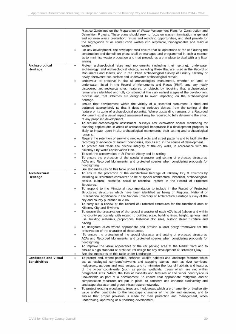
Archaeological Heritage
Protect archaeological sites and monuments (including their setting), underwater archaeology, and archaeological objects, including those that are listed in the Record of Monuments and Places, and in the Urban Archaeological Survey of County Kilkenny or newly discovered sub‐surface and underwater archaeological remain
Endeavour to preserve in situ all archaeological monuments, whether on land or underwater, listed in the Record of Monuments and Places (RMP), and any newly discovered archaeological sites, features, or objects by requiring that archaeological remains are identified and fully considered at the very earliest stages of the development process and that schemes are designed to avoid impacting on the archaeological heritage.
Ensure that development within the vicinity of a Recorded Monument is sited and designed appropriately so that it does not seriously detract from the setting of the feature or its zone of archaeological potential. Where upstanding remains of a Recorded Monument exist a visual impact assessment may be required to fully determine the effect of any proposed development.
To require archaeological assessment, surveys, test excavation and/or monitoring for planning applications in areas of archaeological importance if a development proposal is likely to impact upon in‐situ archaeological monuments, their setting and archaeological remains.
Require the retention of surviving medieval plots and street patterns and to facilitate the recording of evidence of ancient boundaries, layouts etc. in the course of development.
To protect and retain the historic integrity of the city walls, in accordance with the Kilkenny City Walls Conservation Plan.
To seek the conservation of St Francis Abbey and its setting To ensure the protection of the special character and setting of protected structures,
ACAs and Recorded Monuments, and protected species when considering proposals for floodlighting.
See also measures on this table under Landscape Architectural Heritage
To ensure the protection of the architectural heritage of Kilkenny City & Environs by including all structures considered to be of special architectural, historical, archaeological, artistic, cultural, scientific, social or technical interest in the Record of Protected Structures.
To respond to the Ministerial recommendation to include in the Record of Protected Structures, structures which have been identified as being of Regional, National or International significance in the National Inventory of Architectural Heritage survey of the city and county published in 2006.
To carry out a review of the Record of Protected Structures for the functional area of Kilkenny City and Environs
To ensure the preservation of the special character of each ACA listed )above and within the county particularly with regard to building scale, building lines, height, general land use, building materials, proportions, historical plot sizes, historic street furniture and paving
To designate ACAs where appropriate and provide a local policy framework for the preservation of the character of these areas.
To ensure the protection of the special character and setting of protected structures, ACAs and Recorded Monuments, and protected species when considering proposals for floodlighting.
To improve the visual appearance of the car parking area at the Market Yard and to ensure a high standard of architectural design for any development at Bateman Quay.
See also measures on this table under Landscape Landscape and Visual Sensitivities
To protect and, where possible, enhance wildlife habitats and landscape features which act as ecological corridors/networks and stepping stones, such as river corridors, hedgerows, gardens and road verges, and to minimise the loss of habitats and features of the wider countryside (such as ponds, wetlands, trees) which are not within designated sites. Where the loss of habitats and features of the wider countryside is unavoidable as part of a development, to ensure that appropriate mitigation and/or compensation measures are put in place, to conserve and enhance biodiversity and landscape character and green infrastructure networks.
To protect existing woodlands, trees and hedgerows which are of amenity or biodiversity value and/or contribute to the landscape character of the city and environs, and to ensure that proper provision is made for their protection and management, when undertaking, approving or authorising development.

Appropriate Assessment Screening for Proposed Variation to the Kilkenny City and Environs Developement Plan 2014 - 2020
CAAS for Kilkenny County Council 21
To protect views and prospects identified on Figure 7.5 by requiring new development or extensions to existing development to be designed and located so as not to have a significant impact on its character.
To encourage street layouts in newly developed areas which create new vistas to existing and new landmarks, in particular within brownfield sites, the Western Environs and the Loughmacask Local Area Plan lands.
Where the Council believes development has the potential to either diminish or enhance significant views into and/or out of the city and environs, it may require that a visual impact assessment be carried out prior to development being undertaken on any site.
Safeguard the importance of significant archaeological or historic landscapes from developments that would unduly sever or disrupt the relationship, connectivity and/or inter‐visibility between sites.
To seek the protection, and enhancement of significant historic gardens, parklands and designed landscapes in the city and environs, their setting and views to and from them
To require an assessment of the potential visual, heritage and environmental impacts of proposals to floodlight buildings and structures
To ensure that any development occurring along the River Nore will be sensitive in its design and mindful of its proximity to the river.
See also measures on this table under Biodiversity, Flora and Fauna, Archaeological Heritage and Architectural Heritage
Appropriate Assessment Screening for Proposed Variation to the Kilkenny City and Environs Developement Plan 2014 - 2020
CAAS for Kilkenny County Council 22
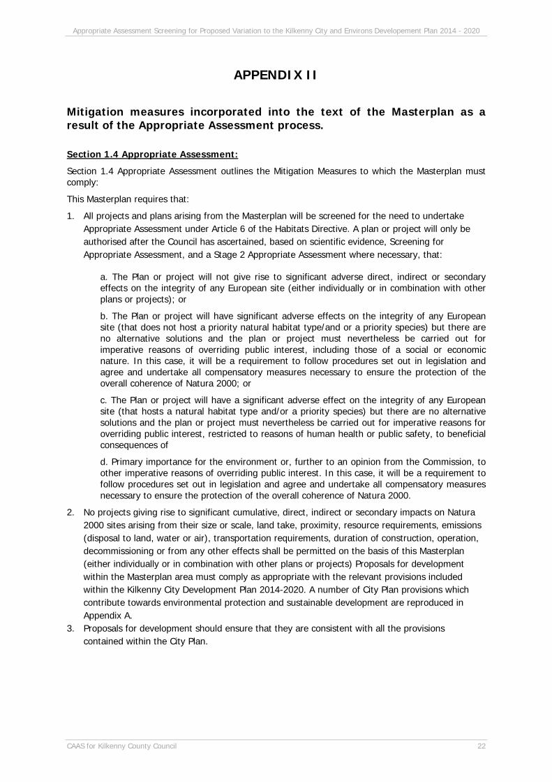
APPENDIX II
Mitigation measures incorporated into the text of the Masterplan as a result of the Appropriate Assessment process.
Section 1.4 Appropriate Assessment:
Section 1.4 Appropriate Assessment outlines the Mitigation Measures to which the Masterplan must comply:
This Masterplan requires that:
1. All projects and plans arising from the Masterplan will be screened for the need to undertake Appropriate Assessment under Article 6 of the Habitats Directive. A plan or project will only be authorised after the Council has ascertained, based on scientific evidence, Screening for Appropriate Assessment, and a Stage 2 Appropriate Assessment where necessary, that:
a. The Plan or project will not give rise to significant adverse direct, indirect or secondary effects on the integrity of any European site (either individually or in combination with other plans or projects); or
b. The Plan or project will have significant adverse effects on the integrity of any European site (that does not host a priority natural habitat type/and or a priority species) but there are no alternative solutions and the plan or project must nevertheless be carried out for imperative reasons of overriding public interest, including those of a social or economic nature. In this case, it will be a requirement to follow procedures set out in legislation and agree and undertake all compensatory measures necessary to ensure the protection of the overall coherence of Natura 2000; or
c. The Plan or project will have a significant adverse effect on the integrity of any European site (that hosts a natural habitat type and/or a priority species) but there are no alternative solutions and the plan or project must nevertheless be carried out for imperative reasons for overriding public interest, restricted to reasons of human health or public safety, to beneficial consequences of
d. Primary importance for the environment or, further to an opinion from the Commission, to other imperative reasons of overriding public interest. In this case, it will be a requirement to follow procedures set out in legislation and agree and undertake all compensatory measures necessary to ensure the protection of the overall coherence of Natura 2000.
2. No projects giving rise to significant cumulative, direct, indirect or secondary impacts on Natura 2000 sites arising from their size or scale, land take, proximity, resource requirements, emissions (disposal to land, water or air), transportation requirements, duration of construction, operation, decommissioning or from any other effects shall be permitted on the basis of this Masterplan (either individually or in combination with other plans or projects) Proposals for development within the Masterplan area must comply as appropriate with the relevant provisions included within the Kilkenny City Development Plan 2014-2020. A number of City Plan provisions which contribute towards environmental protection and sustainable development are reproduced in Appendix A.
3. Proposals for development should ensure that they are consistent with all the provisions contained within the City Plan.

Appropriate Assessment Screening for Proposed Variation to the Kilkenny City and Environs Developement Plan 2014 - 2020
CAAS for Kilkenny County Council 23
Section 3.1.3 Statutory Planning and Policy Framework
The following is an objective of the Masterplan under Section 3.1.3:
o To provide a hierarchy of parks, open spaces and outdoor recreation areas and to use the river corridors of the River Nore, Breagagh and Pococke to provide open space for the city while having due consideration to their ecological sensitivity.
Section 3.1.8 Site Analysis – Linear Park
It is an objective of the Council to;
Objective 6B - To complete the River Nore Linear Park within the lifetime of the Plan.
The Masterplan will propose the creation of a linear park along the River Nore to extend the existing walkways through the city centre while being cogniscent of the river as a Natura 20000 site, a Special Area of Conservation (SAC) and a Special Protection Area (SPA).
Section 3.1.9 Site Analysis – River Bank Conditions
It is an objective of the Masterplan to improve access to the river through the Masterplan area. The detail of this access will be considered in the preparation of the detailed design of the Linear Park and with consideration of the environmental requirements arising from the designation of the River Nore as a SAC and SPA.
Section 4.3.8 Streets/Lanes Strategy
o Create extensions of existing slipways located to the west of Parliament Street on an east west axis reminiscent of the historical burgage plot
o Implement the recommendations of the Cycle Routes Study Implement traffic management and calming schemes for the City as the need arises.
o Have regard to the Architectural Heritage o Have regard to natural heritage and ensure compliance with the requirements of the EU Habitats
and Birds Directives.
An ‘Environmental Considerations’ section, Section 4.3.2 has also been incorporated into the Masterplan. This section addresses the need for appropriate assessment (AA) at project level, particularly in relation to the provision to provide for a linear park along the River Nore.
Section 4.4.7 Water Conservation
Text within this section:
Details of this proposal will need to consider the potential for adverse effects on the ecology of the River Barrow and Nore cSAC and the River Nore SPA as required under Article 6 of the EU Habitats Directive.