protecting water quality in our lakes - north carolina lake
TRANSCRIPT
Mecklenburg County, North Carolina
A Practical Guide For Protecting Water Quality Conditions In Our Lakes
2005
Protecting Water Quality In Our Lakes
watershed6.qxd 8/17/05 1:45 PM Page 1

Introduction 1
Protecting Water Quality...What’s In It For You? 2 Your Health
Your Quality Of LifeEconomics
Fish And WildlifeWe’re All Downstream
Watershed Management 3
Mecklenburg County Lake Watersheds 3Lake Norman Watershed
Mountain Island Lake Watershed Lake Wylie Watershed
Water Quality Conditions In Mecklenburg County Lakes
Buffers And Their Importance 5What Is A Buffer And How Does It Function?
Buffer RegulationsBuffer Requirements
Buffer Violations and RestorationSpecial Permits
Impervious Surfaces Limitations 6
Other Ways To Protect Water Quality 7 Fueling Your Boat
Sewage From Your BoatLitter
Exotic SpeciesFertilizers & Pesticides
More Environmentally-Friendly Ideas For The Homeowner 9Vehicle Maintenance
Yard WasteRecycling
Common Water Quality Problems 10Sewage
Illicit DischargesSedimentationAlgae Blooms
Dumping
What’s Already Being Done To Protect Lake Water Quality? 12Monitoring
Plan ReviewService Requests
Public and Private Land AcquisitionPublic Education and Awareness
Frequently Asked Questions 13
Glossary 14
Contact Directory 15
General Map Of The Catawba River Basin 16
Watershed Protection Overlay Districts 17 & 18
Map Of Major Tributaries And Lakes Of The Catawba River In North Carolina 19
Appendix A: Watershed Buffer Guidelines For Mecklenburg County 20
Protecting Water Quality In Our LakesA practical guide for protecting water quality conditions in our lakes and related regulations for homeowners in Mecklenburg County, N.C.
Prepared by:
Mecklenburg County Water Quality ProgramLand Use and Environmental Services Agency
700 N. Tryon Street, Suite 205Charlotte, NC 28202
Phone: (704) 336-5500Fax: (704) 336-4391
http://waterquality.charmeck.org
August 2005
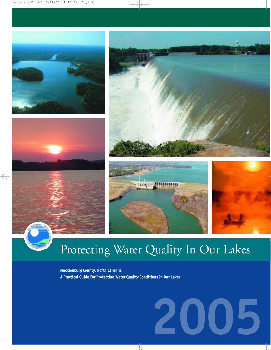
Photos on cover and back depict scenery along the Catawba River.
Photos by David Buetow, The Trust For Public Land, Steve Jadlocki, Rusty Rozzelle and Duke Power.
Ta b l e o f C o n te n t s
Construction of Mountain Island Dam, September 12, 1923.
watershed6.qxd 8/17/05 1:45 PM Page 2

Introduction 1
Protecting Water Quality...What’s In It For You? 2 Your Health
Your Quality Of LifeEconomics
Fish And WildlifeWe’re All Downstream
Watershed Management 3
Mecklenburg County Lake Watersheds 3Lake Norman Watershed
Mountain Island Lake Watershed Lake Wylie Watershed
Water Quality Conditions In Mecklenburg County Lakes
Buffers And Their Importance 5What Is A Buffer And How Does It Function?
Buffer RegulationsBuffer Requirements
Buffer Violations and RestorationSpecial Permits
Impervious Surfaces Limitations 6
Other Ways To Protect Water Quality 7 Fueling Your Boat
Sewage From Your BoatLitter
Exotic SpeciesFertilizers & Pesticides
More Environmentally-Friendly Ideas For The Homeowner 9Vehicle Maintenance
Yard WasteRecycling
Common Water Quality Problems 10Sewage
Illicit DischargesSedimentationAlgae Blooms
Dumping
What’s Already Being Done To Protect Lake Water Quality? 12Monitoring
Plan ReviewService Requests
Public and Private Land AcquisitionPublic Education and Awareness
Frequently Asked Questions 13
Glossary 14
Contact Directory 15
General Map Of The Catawba River Basin 16
Watershed Protection Overlay Districts 17 & 18
Map Of Major Tributaries And Lakes Of The Catawba River In North Carolina 19
Appendix A: Watershed Buffer Guidelines For Mecklenburg County 20
Protecting Water Quality In Our LakesA practical guide for protecting water quality conditions in our lakes and related regulations for homeowners in Mecklenburg County, N.C.
Prepared by:
Mecklenburg County Water Quality ProgramLand Use and Environmental Services Agency
700 N. Tryon Street, Suite 205Charlotte, NC 28202
Phone: (704) 336-5500Fax: (704) 336-4391
http://waterquality.charmeck.org
August 2005
Photos on cover and back depict scenery along the Catawba River.
Photos by David Buetow, The Trust For Public Land, Steve Jadlocki, Rusty Rozzelle and Duke Power.
Ta b l e o f C o n te n t s
Construction of Mountain Island Dam, September 12, 1923.
watershed6.qxd 8/17/05 1:45 PM Page 2

Protecting Water Quality...What’s In It For You?Consider some of the important reasons to help protect thequality of our lakes and creeks in Mecklenburg County:
Your Health• With Lake Norman and Mountain Island Lake being the
sources for our drinking water, we do not want to ever runthe risk of producing more contamination than the watertreatment technology can handle.
• High bacteria levels put swimmers and other lake recreationists at risk of eye and ear infections. Childrenand elderly are especially susceptible to bacterial infections.
Your Quality Of Life An attractive lake offering an assortment of recreationalactivities improves our quality of life. Without clean, healthywaters, lake residents and visitors alike cannot enjoy theseactivities to the fullest. Protecting our lakes maintains ourquality of life.
Economics• Let’s face it: poor water quality affects your wallet (or
purse). People are drawn to live near beautiful, clean lakesand creeks - not unsightly, dirty waters. For obvious reasons, property values are higher in areas in highdemand. Polluted waters can quickly ruin an area’s appeal.
• Polluted water is more expensive to treat and may result inan increased water bill.
• Recreational water opportunities attract visitors and residents to lake amenities, contributing to the local economy.
Fish And WildlifeGiven that fish and other aquatic wildlife spend all (or most)of their time in the water, pollution has a great impact ontheir health. Most organisms are adapted to a particularhabitat and water quality level, so even small amounts ofpollution or changes in the surrounding environment canhave a negative effect.
We’re All DownstreamLake Norman, Mountain Island Lake and Lake Wylie, are allpart of the Catawba River system (see page 19). As with anywaterway, what happens upstream in the system impacts thewater and people downstream. The Catawba River system iscomprised of 11 hydropower reservoirs, starting with LakeJames at the foot of the Blue Ridge Mountains and leadingdown to Lake Wateree in central South Carolina. Smallerrivers and creeks also flow into the river’s main stem.
Altogether, the Catawba River basin covers over 4,750square miles in 12 counties and has nearly 3,100 miles offree-flowing rivers and creeks. With over 1.5 million residents living within this basin, it is one of the most densely populated river basins in North Carolina. Just asthose who live upstream of Mecklenburg County impact thewater quality flowing into our area, we impact the waterquality flowing out of our area. This is the same water thatdownstream residents rely on for drinking, swimming, fishing, and a variety of other uses.
Quite naturally, families and businesses located directlyalong the Catawba River lakes and creeks have the greatestpotential for impacting the water supply given their proximity. For this reason, lakeshore and creekside residentsmust be especially mindful of how they can affect the waternearby...and downstream.
“Treat the earth well. It was not given to you by your parents. It was loaned to you by your children.” Kenyan Proverb
Canoeing is a favorite recreational activity enjoyed on Mountain Island Lake.
Lakes have a special allure that draw people to their shores. They provide beautiful scenery and
wonderful recreational opportunities like boating, fishing and swimming. In the past decade,
Mecklenburg County has experienced an escalated demand for property near and along our lakes.
As people have relocated to the area, businesses have flourished and infrastructure has been built
to support the development boom. All of this growth has led to increased pressure on the quality
of water in our lakes and their connecting creeks. Proximity to our precious waters gives lake
residents a special opportunity, if not responsibility, to have a positive impact on water quality.
Accepting this responsibility helps protect the water and adjacent land for your enjoyment as well
as that of other residents and future generations.
This booklet is intended for residents who own property and/or live within a lake watershed in
Mecklenburg County. It provides valuable information about laws and regulations pertinent to
lake-area living. In addition, it gives advice on how to maintain a lifestyle that has a low impact
on the water and the environment in general. Take the time to read through this booklet and you
may find the answers to some of your questions and perhaps learn something you did not know.
1 2
watershed6.qxd 8/17/05 1:45 PM Page 4

Mountain Island Lake Watershed• Smallest of the three (3) lakes bordering
Mecklenburg County.
• Drinking water source for Mecklenburg County, Gastoniaand Mount Holly.
• Approximately 80 million gallons of water are withdrawndaily to serve Charlotte-Mecklenburg residents.
• Mecklenburg County’s McDowell, Torrence and GarCreeks flow into Mountain Island Lake.
• Total surface area of 2,788 acres.
• Individual watershed encompasses 70 square miles.
• Total watershed drains 1,860 square miles.
• Approximately 61 miles of shoreline, with an estimated 37 miles in Mecklenburg County.
Currently, Mountain Island Lake has good to excellent waterquality. However, streams that flow into the lake are declining in terms of water quality, particularly McDowellCreek that winds through the Town of Huntersville.McDowell Creek flows to McDowell Creek Cove which hasexperienced a significant decline in water quality conditionsdue to increased land development in the watershed. Itswater quality is among the poorest in Mecklenburg Countydue to increased sediment and nutrient levels. Of particularconcern is that McDowell Creek Cove is located upstream ofCharlotte-Mecklenburg’s drinking water intake on MountainIsland Lake. Significant efforts are being undertaken by theMecklenburg County Water Quality Program and Town ofHuntersville to reduce pollutants discharged to this cove andrestore water quality conditions to ensure protection of ourdrinking water supply.
Lake Wylie Watershed• Very long lake with a surface area of 12,139 acres.
• Largest individual watershed along the Catawba River,encompassing 1,160 square miles.
• Total drainage area is 3,020 square miles.
• Drinking water source for Belmont and Rock Hill.
• Long and Paw Creeks flow into this watershed inMecklenburg County.
• Approximately 327 miles of shoreline, with an estimated67 miles located in Mecklenburg County.
Overall, Lake Wylie has good water quality. However, its uses are currently threatened. Numerous point and non-point pollution sources have contributed to water quality degradation in its embayments and tributary arms.
High nutrient levels have been linked to algae blooms andfish kills in warmer months. The primary sources of pollution are urban runoff and wastewater treatment plantdischarges. Over 100 wastewater treatment plants are locatedalong tributaries to Lake Wylie in Gaston and Lincoln counties. Urban runoff from Mecklenburg County and agricultural runoff from Gaston and Lincoln counties arealso significant problems.
In addition, Lake Wylie is becoming more developed. In1995, the population density within Mecklenburg County’sportion of the Lake Wylie watershed was 134 persons persquare mile, which is low compared to the MecklenburgCounty average of 876 persons per square mile. The percentage of open space was also the highest in the county.However, the population is increasing and the open space isdecreasing, as there is a greater desire to live along LakeWylie’s shores. As previously discussed, this leads to increasingnon-point source pollution and water quality degradation.
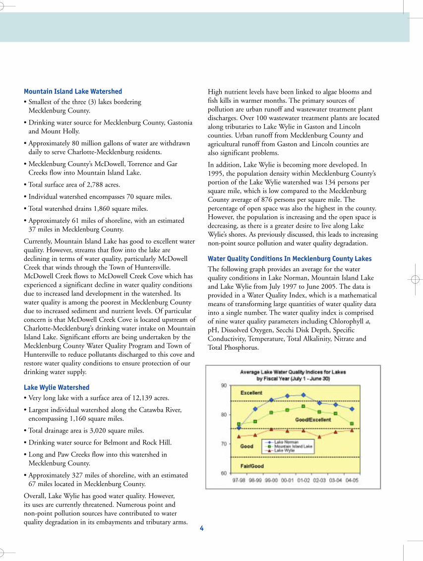
Water Quality Conditions In Mecklenburg County Lakes The following graph provides an average for the water quality conditions in Lake Norman, Mountain Island Lakeand Lake Wylie from July 1997 to June 2005. The data isprovided in a Water Quality Index, which is a mathematicalmeans of transforming large quantities of water quality datainto a single number. The water quality index is comprisedof nine water quality parameters including Chlorophyll a,pH, Dissolved Oxygen, Secchi Disk Depth, SpecificConductivity, Temperature, Total Alkalinity, Nitrate andTotal Phosphorus.
Watershed ManagementPast efforts to reduce pollution have focused more on factories than subdivisions. After all, it is easier to regulatean industrial site than to track down the neighbor whoseexcessively applied fertilizer washed off into the lake. That iswhy for years, regulations were directed more at “pointsource” pollution, meaning the pollutant discharges into thewater by a direct route from an identifiable source, likeindustrial plants and wastewater treatment facilities. Yet wenow know that land development activities (subdivisions,apartment complexes, shopping malls, etc.) account for agreat deal of water pollution, too. Fertilizers and pesticidesapplied to lawns, oil, antifreeze and other chemicals drippedonto parking lots, and metals deposited along roadways fromtire and automobile wear are picked up by storm waterrunoff and carried to nearby streams and lakes causing waterquality degradation. Nationwide it is estimated that 50% ofwater quality degradation is caused by pollution carried bystorm water runoff from developed areas, which is called“non-point source” pollution because it does not originatefrom a fixed location. Much of today’s focus is on managingor controlling this non-point source pollution through aconcept called watershed management.
For a particular body of water, a watershed (or drainagebasin) is the surrounding land area that drains into thatbody of water. For a lake, rain water may first drain to astream within a watershed that then flows into the lake. On its way, water travels across farm fields, forested land,suburban lawns, parking lots and city streets and picks up avariety of non-point source pollutants. Reducing the non-point source pollutants by addressing individual behaviorsthat impact the environment is a vital aspect of watershedmanagement. Later in this booklet, you will find tips onwhat you can do to help.
Mecklenburg County Lake WatershedsThe entire western border of Mecklenburg County is comprised of 194 miles of shoreline in three (3) of the 11 lakes in the Catawba River system, including LakeNorman, Mountain Island Lake and Lake Wylie. Providedbelow is general information concerning these lakes.
Lake Norman Watershed• Lake Norman is located along the northwestern border of
Mecklenburg County.
• Largest man-made lake in North Carolina.
• Drinking water source for Mooresville, MecklenburgCounty and Lincoln County.
• Approximately 20 million gallons of water are withdrawndaily to serve Mecklenburg County.
• Supports a wide variety of aquatic life, including large fish populations.
• Total surface area of 32,510 acres.
• Individual watershed encompasses 340 square miles.
• Total drainage area including all lake and river watershedsupstream is 1,790 square miles.
• Approximately 520 miles of shoreline, with an estimated90 miles in Mecklenburg County.
Currently, Lake Norman has the best water quality of thethree lakes in Mecklenburg County. In the past, the watershed had a fairly low population density and a largepercentage of wooded and open space, which are significantfactors contributing toward its good quality. However, thishas changed. Growth pressures within Lake Norman’s watershed continue to threaten the water quality and thelake’s main uses such as drinking water and recreation.
Lake Norman is the largest man-made lake in North Carolina.
3 4
Charlotte-Mecklenburg Utilities’ water intake on Mountain Island Lake.
watershed6.qxd 8/17/05 1:45 PM Page 6
Mountain Island Lake Watershed• Smallest of the three (3) lakes bordering
Mecklenburg County.
• Drinking water source for Mecklenburg County, Gastoniaand Mount Holly.
• Approximately 80 million gallons of water are withdrawndaily to serve Charlotte-Mecklenburg residents.
• Mecklenburg County’s McDowell, Torrence and GarCreeks flow into Mountain Island Lake.
• Total surface area of 2,788 acres.
• Individual watershed encompasses 70 square miles.
• Total watershed drains 1,860 square miles.
• Approximately 61 miles of shoreline, with an estimated 37 miles in Mecklenburg County.
Currently, Mountain Island Lake has good to excellent waterquality. However, streams that flow into the lake are declining in terms of water quality, particularly McDowellCreek that winds through the Town of Huntersville.McDowell Creek flows to McDowell Creek Cove which hasexperienced a significant decline in water quality conditionsdue to increased land development in the watershed. Itswater quality is among the poorest in Mecklenburg Countydue to increased sediment and nutrient levels. Of particularconcern is that McDowell Creek Cove is located upstream ofCharlotte-Mecklenburg’s drinking water intake on MountainIsland Lake. Significant efforts are being undertaken by theMecklenburg County Water Quality Program and Town ofHuntersville to reduce pollutants discharged to this cove andrestore water quality conditions to ensure protection of ourdrinking water supply.
Lake Wylie Watershed• Very long lake with a surface area of 12,139 acres.
• Largest individual watershed along the Catawba River,encompassing 1,160 square miles.
• Total drainage area is 3,020 square miles.
• Drinking water source for Belmont and Rock Hill.
• Long and Paw Creeks flow into this watershed inMecklenburg County.
• Approximately 327 miles of shoreline, with an estimated67 miles located in Mecklenburg County.
Overall, Lake Wylie has good water quality. However, its uses are currently threatened. Numerous point and non-point pollution sources have contributed to water quality degradation in its embayments and tributary arms.
High nutrient levels have been linked to algae blooms andfish kills in warmer months. The primary sources of pollution are urban runoff and wastewater treatment plantdischarges. Over 100 wastewater treatment plants are locatedalong tributaries to Lake Wylie in Gaston and Lincoln counties. Urban runoff from Mecklenburg County and agricultural runoff from Gaston and Lincoln counties arealso significant problems.
In addition, Lake Wylie is becoming more developed. In1995, the population density within Mecklenburg County’sportion of the Lake Wylie watershed was 134 persons persquare mile, which is low compared to the MecklenburgCounty average of 876 persons per square mile. The percentage of open space was also the highest in the county.However, the population is increasing and the open space isdecreasing, as there is a greater desire to live along LakeWylie’s shores. As previously discussed, this leads to increasingnon-point source pollution and water quality degradation.
Water Quality Conditions In Mecklenburg County Lakes The following graph provides an average for the water quality conditions in Lake Norman, Mountain Island Lakeand Lake Wylie from July 1997 to June 2005. The data isprovided in a Water Quality Index, which is a mathematicalmeans of transforming large quantities of water quality datainto a single number. The water quality index is comprisedof nine water quality parameters including Chlorophyll a,pH, Dissolved Oxygen, Secchi Disk Depth, SpecificConductivity, Temperature, Total Alkalinity, Nitrate andTotal Phosphorus.
Watershed ManagementPast efforts to reduce pollution have focused more on factories than subdivisions. After all, it is easier to regulatean industrial site than to track down the neighbor whoseexcessively applied fertilizer washed off into the lake. That iswhy for years, regulations were directed more at “pointsource” pollution, meaning the pollutant discharges into thewater by a direct route from an identifiable source, likeindustrial plants and wastewater treatment facilities. Yet wenow know that land development activities (subdivisions,apartment complexes, shopping malls, etc.) account for agreat deal of water pollution, too. Fertilizers and pesticidesapplied to lawns, oil, antifreeze and other chemicals drippedonto parking lots, and metals deposited along roadways fromtire and automobile wear are picked up by storm waterrunoff and carried to nearby streams and lakes causing waterquality degradation. Nationwide it is estimated that 50% ofwater quality degradation is caused by pollution carried bystorm water runoff from developed areas, which is called“non-point source” pollution because it does not originatefrom a fixed location. Much of today’s focus is on managingor controlling this non-point source pollution through aconcept called watershed management.
For a particular body of water, a watershed (or drainagebasin) is the surrounding land area that drains into thatbody of water. For a lake, rain water may first drain to astream within a watershed that then flows into the lake. On its way, water travels across farm fields, forested land,suburban lawns, parking lots and city streets and picks up avariety of non-point source pollutants. Reducing the non-point source pollutants by addressing individual behaviorsthat impact the environment is a vital aspect of watershedmanagement. Later in this booklet, you will find tips onwhat you can do to help.
Mecklenburg County Lake WatershedsThe entire western border of Mecklenburg County is comprised of 194 miles of shoreline in three (3) of the 11 lakes in the Catawba River system, including LakeNorman, Mountain Island Lake and Lake Wylie. Providedbelow is general information concerning these lakes.
Lake Norman Watershed• Lake Norman is located along the northwestern border of
Mecklenburg County.
• Largest man-made lake in North Carolina.
• Drinking water source for Mooresville, MecklenburgCounty and Lincoln County.
• Approximately 20 million gallons of water are withdrawndaily to serve Mecklenburg County.
• Supports a wide variety of aquatic life, including large fish populations.
• Total surface area of 32,510 acres.
• Individual watershed encompasses 340 square miles.
• Total drainage area including all lake and river watershedsupstream is 1,790 square miles.
• Approximately 520 miles of shoreline, with an estimated90 miles in Mecklenburg County.
Currently, Lake Norman has the best water quality of thethree lakes in Mecklenburg County. In the past, the watershed had a fairly low population density and a largepercentage of wooded and open space, which are significantfactors contributing toward its good quality. However, thishas changed. Growth pressures within Lake Norman’s watershed continue to threaten the water quality and thelake’s main uses such as drinking water and recreation.
Lake Norman is the largest man-made lake in North Carolina.
3 4
Charlotte-Mecklenburg Utilities’ water intake on Mountain Island Lake.
watershed6.qxd 8/17/05 1:45 PM Page 6

Buffer Violations And RestorationWhere a buffer area has been found to be disturbed, aNotice Of Violation (NOV) may be issued to the propertyowner by the local zoning department or their designee. The violation requires that the property owner restore thebuffer to a condition acceptable under the Watershed BufferGuidelines for Mecklenburg County, NC (Appendix A).Monetary penalties may also be assessed. Restorationinvolves replanting trees and shrubs to a certain density inthe buffer, which is given in the guidelines. A restorationplan must be submitted and approved by the MecklenburgCounty Water Quality Program.
An appeal of the violation may be submitted to the ZoningDepartment. If the violation is not corrected or no appeal ismade within 60 days of the date of the NOV, the ZoningDepartment may (1) revoke the certification of occupancy,making continued occupancy unlawful; (2) issue a citationand, if unpaid, a judgment could become a lien on the prop-erty; (3) seek an injunction; or (4) issue a criminal summons.
Special PermitsA permit is required when conducting certain activities neara lakeshore in Mecklenburg County. Duke Power’s LakeManagement Division has the following six (6) permittingprograms: (1) commercial facilities (boat slips at condominiums, campgrounds, marinas, etc.), (2) private single-family (boat docks or piers at a single-family residence), (3) conveyance (water intakes, bridges, and roadcrossings), (4) shoreline stabilization (rip-rapping and seawall construction), (5) excavation or dredging, and (6)miscellaneous uses for activities such as installing heat coilsor withdrawing greater than one million gallons of water per day. Withdrawal of less than this amount for domestic purposes does not require a permit, but does require a letterof intent to the Duke Power Lake Management Office.Contact their office at 1-800-443-5193 if you think youmight need a permit.
Any activity that could potentially disturb the buffer requiresthe submittal of an Application for Temporary BufferDisturbance to the Mecklenburg County Water QualityProgram. Disturbed areas would include all areas of thebuffer where the natural ground cover has been graded,removed or altered. For your convenience, an ApplicationFor Temporary Buffer Disturbance has been included inAppendix A.
Impervious Surfaces LimitationsOne component of the watershed protection regulations isbuilt-upon area (BUA) or impervious surfaces. The water-shed regulations define BUA as “impervious or partiallyimpervious material.” BUA includes but is not limited toasphalt, concrete, stone, brick, terrazzo, roofing, ceramic,buildings, pavement, recreational facilities, gravel areas,metal, wood, plastic, rubber, pervious asphalt, perviouspavers, and outdoor turf/carpet. Pervious surfaces includegrass, sand, soil, pine straw, mulch, wooden slated decks,surface water and the water area of a swimming pool.Limitations on the amount of BUA within a drinking watersupply watershed are critical to protecting water quality.Research has shown that there is a direct correlation betweenthe amount of impervious surfaces in a watershed and thatwatershed’s water quality conditions. Generally, the moreimpervious surface coverage, the more polluted the waterbody. Impervious surfaces have many negative effects onwater quality:
• Reduce the amount of pervious ground cover, which prevents storm water from infiltrating into the ground andreplenishing the groundwater.
• Act as a direct conduit for non-point source pollutants towash into nearby water bodies from parking lots, roads,lawns, etc.
• Cause increased runoff volume and velocity resulting inexcessive erosion in buffers and streambeds.
• Linked to thermal pollution in water bodies, which candeplete oxygen levels and stress aquatic life.
• Increase downstream flooding due to the loss of permeableareas for soaking up storm water.
Buffers And Their Importance What Is A Buffer And How Does It Function?Buffers are natural, vegetated areas (preferably forested) adjacent to lakes and creeks. These buffers serve to filter pollutants from storm water, absorb runoff and reduce thevolume of runoff, thereby reducing erosion and pollutants.
In order for buffers to provide an effective filter, storm watermust sheet flow across the buffer and the buffer must be ofsufficient width. In North Carolina, the recently adoptedCatawba Buffer Rules require a 50-foot minimum bufferwidth for new development along the Catawba River. Wider buffers may be necessary for steeper slopes, areasdownstream of intense development, or for extra protectionof highly valued uses such as drinking water.
A well-established buffer is generally self-perpetuating andrequires little maintenance. Native trees and shrubs are recommended for their hardiness, effective canopy and rootstructure. Buffer canopies intercept rainfall, thereby minimizing soil disturbance. Buffers also improve waterquality by providing shade, which lowers water temperature.Cool water carries more dissolved oxygen than warmer waterand is essential to the survival of fish and other aquaticwildlife species that are sensitive to changes in temperature.Buffers also provide woody debris for fish habitat.
Buffer RegulationsIn 1992, North Carolina passed a law requiring local governments to develop watershed regulations aimed at protecting water quality in lakes classified as drinking watersupplies. Minimum standards were established by the state,and local governments were required to pass regulations fortheir jurisdictions. Most jurisdictions in MecklenburgCounty adopted more stringent watershed regulations andincorporated them into subdivision, land development,and/or zoning ordinances. A majority of these regulations
address the following three issues: (1) development density(amount of built-upon or impervious area), (2) bufferwidths and (3) land use. Those who live within a lake watershed should be most familiar with buffer requirementsin their area. A map (page 17 thru 18) is provided to helpdetermine which rules apply to where you live. Generalbuffer requirements and guidelines for all lake watersheds aresummarized in Appendix A (Watershed Buffer Guidelines forMecklenburg County, NC). Other pertinent information,such as suggested tree plantings for buffer areas and guidelines for stepping stone pathways, can be found in theappendix as well.
Buffer Requirements Undisturbed buffers required along the shoreline of allMecklenburg County lakes are measured from the full pond elevation:
• Lake Norman - 760 feet
• Mountain Island Lake - 648 feet
• Lake Wylie - 569.4 feet
Along all perennial streams, undisturbed buffers are measured from the top of the bank on each side of thestream. Critical Areas (CA) are generally located in closeproximity to surface waters. Such areas are protected byhigher standards because of the greater risk of water qualitydegradation from pollution. Protected Areas (PA) are locatedbeyond the CA in the watershed. Fewer restrictions apply tothe PA because the risk of water quality degradation frompollution is less. Development density is typically addressedby either a low-density option, (single-family detacheddwellings) or a high-density option, (multi-family dwellingsor commercial development). There are separate watershedregulations and buffer requirements for each of the three (3) lakes. Refer to Appendix A for more information aboutspecific buffer and watershed requirements.
A natural forested area adjacent to surface water body is called a buffer.
5 6
Water running over Mountain Island Dam following heavy rains in
September 2004.
Building boat slips and stabilizing shorelines on lakes in Mecklenburg Countyrequire a special permit.
watershed6.qxd 8/17/05 1:46 PM Page 8

Lake NormanBoat Rack Marina
Holiday Harbor Marina
Inland Sea Marina
Kings Point Marina
Lake Norman Marina
Midtown Sundries Restaurant
Harborside Marina
North Bridge Marina
Westport Marina
Lake WylieHarbortowne Marina
River Hills Marina
Tega Cay Marina
• To minimize the need to pump out your system, useonshore rest room facilities when possible.
• Keep your MSD properly maintained.
LitterPlastic and litter not only ruin the natural beauty of thewater, they can also injure aquatic life, clog water intakesand damage boat propellers. Dumping garbage into thewater is illegal and subject to civil penalties and/or criminal sanctions.
What you can do to help:• Do not throw any litter overboard. If the wind causes
something to blow overboard, go back and pick it up.
• Install a garbage can on your boat.
• If you see litter in the water, pick it up and bring it back toshore for proper disposal.
Exotic Species Exotic species are plants or animals living in an area which isnot their native territory. Aquatic exotic species are spreadfrom one water body to another mainly by boats andhumans. Exotics often flourish and out-compete nativespecies because there are no natural predators or diseases tocontrol the population.
Exotic plants can especially become a nuisance to boatersand swimmers. Hydrilla is one type of exotic plant that hasbeen found in area lakes. The plant has become a nuisancein Mountain Island Lake and Lake Norman. Hydrilla formsnearly impenetrable mats of stems and leaves at the surfaceof the water. A few of the problems it may cause are crowding of beneficial native vegetation, interference withpublic water supplies, and blocking of docks, marinas andboat launching sites. Asiatic clams and zebra mussels are twoexotic animals that have caused extensive damage to aquaticecosystems. Asiatic clams have been found in area lakes,while zebra mussels have not yet made it into the CatawbaRiver system.
BUA limitations for each watershed protection district within Mecklenburg County are provided in the chart onpages 2 through 4 of Appendix A. Every development withina drinking water supply watershed must show that it is incompliance with the BUA limitations during the designphase. The developer of a project must allocate a maximumamount of BUA to each lot within a development to ensurethat the development as a whole does not exceed the maximum allowed. Single-family residents will often findthis allocated amount on their deed and/or plat. BUA istracked for every property in Mecklenburg County by theZoning Department. Homeowners and potential home buyers in the watershed protection area should be aware ofthese restrictions and research their individual BUA limitations. These restrictions may prohibit a home addition,sidewalk, out building or driveway expansion.
When the BUA of a development exceeds the establishedthreshold, best management practices or BMPs must beinstalled by the developer as per the watershed regulations to collect and treat storm water runoff for removal of non-point source pollutants prior to discharge to surfacewaters. Wet ponds, the most commonly used BMP aroundthe lakes, function by detaining storm water long enough forpollutants to settle out resulting in the discharge of cleanerwater to the lake.
Other Ways To Protect Water QualityFueling Your BoatPetroleum contains toxic compounds that are harmful to fish and shellfish. Under federal law, it is illegal to dischargeoil or oily waste into U.S. waters. Violators are subject to substantial civil penalties and/or criminal sanctions, includ-ing fines of up to $5,000 per violation and imprisonment.
What you can do to help:• Avoid “topping off ” your gas tank when refueling.
• Install a fuel/air separator to prevent accidental overflowsfrom the tank vent line.
• Ask your fuel dock to install automatic cutoff nozzles or alarms.
• Report spills to the Mecklenburg County Water QualityProgram at (704) 336-5500.
• Do not apply soap or detergents to the water when a spilloccurs. Doing so causes the petroleum to sink into thewater column instead of staying on the surface where itcan be contained and removed.
Sewage From Your BoatSewage contains disease-causing pathogens that are harmful to humans and aquatic life. It also contains largeamounts of nutrients that can stimulate algae growth anddeplete oxygen in the water. Discharging sewage into watersof the U.S. is illegal and subject to civil penalties and/orcriminal sanctions.
What you can do to help:• Install a Type III Marine Sanitation Device (MSD) such as
a holding tank on your boat. These can be emptied at anonshore pump-out station. Please be aware that MSDsdesigned to treat and discharge waste into the lake are illegal.
• Encourage your marina to install a pump-out station.Federal funds for pump out stations are available under theClean Vessel Act. The following marinas currently havepublic pump-outs:
7 8
Hydrilla has two highly reproductive structures at the end of its stems and roots(highlighted above).Increased impervious cover leads to increased non-point source pollution that
can be controlled using wet ponds.
watershed6.qxd 8/17/05 1:46 PM Page 10

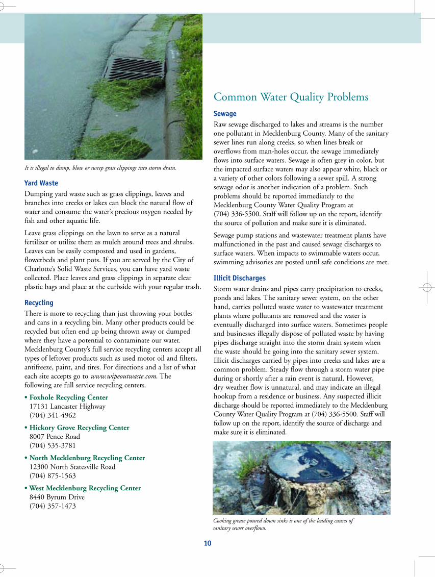
Yard Waste Dumping yard waste such as grass clippings, leaves andbranches into creeks or lakes can block the natural flow ofwater and consume the water’s precious oxygen needed byfish and other aquatic life.
Leave grass clippings on the lawn to serve as a natural fertilizer or utilize them as mulch around trees and shrubs.Leaves can be easily composted and used in gardens,flowerbeds and plant pots. If you are served by the City ofCharlotte’s Solid Waste Services, you can have yard wastecollected. Place leaves and grass clippings in separate clearplastic bags and place at the curbside with your regular trash.
Recycling There is more to recycling than just throwing your bottlesand cans in a recycling bin. Many other products could berecycled but often end up being thrown away or dumpedwhere they have a potential to contaminate our water.Mecklenburg County’s full service recycling centers accept alltypes of leftover products such as used motor oil and filters,antifreeze, paint, and tires. For directions and a list of whateach site accepts go to www.wipeoutwaste.com. The following are full service recycling centers.
• Foxhole Recycling Center 17131 Lancaster Highway (704) 341-4962
• Hickory Grove Recycling Center 8007 Pence Road(704) 535-3781
• North Mecklenburg Recycling Center 12300 North Statesville Road (704) 875-1563
• West Mecklenburg Recycling Center 8440 Byrum Drive (704) 357-1473
Common Water Quality ProblemsSewage Raw sewage discharged to lakes and streams is the numberone pollutant in Mecklenburg County. Many of the sanitarysewer lines run along creeks, so when lines break or overflows from man-holes occur, the sewage immediatelyflows into surface waters. Sewage is often grey in color, butthe impacted surface waters may also appear white, black ora variety of other colors following a sewer spill. A strongsewage odor is another indication of a problem. Such problems should be reported immediately to theMecklenburg County Water Quality Program at (704) 336-5500. Staff will follow up on the report, identifythe source of pollution and make sure it is eliminated.
Sewage pump stations and wastewater treatment plants havemalfunctioned in the past and caused sewage discharges tosurface waters. When impacts to swimmable waters occur,swimming advisories are posted until safe conditions are met.
Illicit Discharges Storm water drains and pipes carry precipitation to creeks,ponds and lakes. The sanitary sewer system, on the otherhand, carries polluted waste water to wastewater treatmentplants where pollutants are removed and the water is eventually discharged into surface waters. Sometimes peopleand businesses illegally dispose of polluted waste by havingpipes discharge straight into the storm drain system whenthe waste should be going into the sanitary sewer system.Illicit discharges carried by pipes into creeks and lakes are acommon problem. Steady flow through a storm water pipeduring or shortly after a rain event is natural. However, dry-weather flow is unnatural, and may indicate an illegalhookup from a residence or business. Any suspected illicitdischarge should be reported immediately to the MecklenburgCounty Water Quality Program at (704) 336-5500. Staff willfollow up on the report, identify the source of discharge andmake sure it is eliminated.
What you can do to help:• Remove all plant material from boats, trailers and vehicles.
Plants can survive two to three days out of water and aslong as two weeks in a bilge.
• Drain your livewells, bilge water and transom wells beforeleaving the boat landing.
• Do not dump aquatic plants from your aquarium or garden ponds into a lake or stream.
• Do not remove Grass Carp from the lakes. Grass Carp areoften released into lakes by state and local agencies to feedon Hydrilla.
Fertilizers and PesticidesFertilizers contain large amounts of nutrients like nitrogenand phosphorus, which stimulate plant growth. Whenimproperly or excessively applied, fertilizer can be transported by storm water runoff and deposited into ourlakes and creeks. In the water, fertilizer stimulates algaegrowth. Excessive algae growth or “algae blooms” often occurin the summer. These blooms can cause fish kills by depleting the water of its oxygen supply.
Many pesticides and herbicides contain a variety of toxiccompounds and heavy metals, which are harmful to theenvironment. When applied improperly or in excess, thesecompounds can enter our lakes and creeks where they cankill fish and other aquatic life and contaminate drinkingwater supplies.
Making good decisions and following a few easy guidelinescan minimize the adverse effects fertilizers, pesticides, andherbicides have on our environment.
What you can do to help:• Always follow label directions. Make sure the product is
appropriate for your intended use.
• Never apply when heavy rain is expected within 12 hours.
• Do not apply within 50 feet of lakes, creeks or near stormdrains and ditches.
• Test your soil to determine what, if any, nutrients yourlawn needs. Contact Mecklenburg County’s CooperativeExtension Service for a free test kit and assistance at (704) 336-2561.
• Use alternatives that are less harmful to the environment.These are often available at your local hardware or lawnand garden store.
• Spot spray pest and weed problems whenever possible.
• Store fertilizers, pesticides and herbicides in a locked, dryplace safe from flooding and accidental spillage.
• Use native trees and shrubs for landscaping. They typicallyhave fewer pest problems and require less water.
• Utilize natural areas for landscaping instead of plantingturf grass. This will reduce the need for fertilizers.
More Environmentally-Friendly IdeasFor The HomeownerVehicle Maintenance Have you ever looked at the parking lot at your favoritemall? Virtually every space is stained with drippings fromcars. When it rains, this accumulated oil, antifreeze andother harmful fluids enter nearby storm drains and eventually end up in local surface waters. All storm drains inCharlotte-Mecklenburg drain directly into creeks and lakes.
Proper vehicle maintenance can not only prevent such contamination, but also can increase gas mileage and reduceairborne pollutants. If you wash your car at home, wash iton the grass to prevent harmful soaps and detergents fromrunning off into nearby storm drains. In addition, usebiodegradable detergent and recycle used antifreeze andmotor oil.
9 10
The Grass Carp can eat several times its body weight in plant material each day.
It is illegal to dump, blow or sweep grass clippings into storm drain.
Cooking grease poured down sinks is one of the leading causes of sanitary sewer overflows.
watershed6.qxd 8/17/05 1:46 PM Page 12

What’s Already Being Done To Protect Lake Water Quality?Lakes and creeks have played a vital role in attracting peopleto our area. Protecting these waters is important to sustaining a healthy local economy and livable community.the Mecklenburg County Water Quality Program conductsnumerous activities for the purpose of lake and stream waterquality protection.
Monitoring Mecklenburg County has 25 monitoring sites on the lakesand 58 sites along the creeks. The goal of the monitoringprogram is to identify and eliminate sources of water pollution and protect and restore water quality conditions.The monitoring sites were selected to provide an overall representation of water quality conditions throughoutMecklenburg County. The data collected gives a sense of theoverall water quality conditions, helps track water qualitytrends and helps pinpoint specific water pollution problems.Monitoring on the 25 sites on Lake Norman, MountainIsland Lake and Lake Wylie are conducted monthly duringthe summer (May through September) when there isincreased recreation and bimonthly from October to April. Monitoring of Lake Davidson and Lake Cornelius is performed monthly during the summer. Monitoring activities include collecting and analyzing samples for pollution indicators such as fecal coliform bacteria, phosphorus, nitrogen, chlorophyll a, turbidity and solids.Field tests are also conducted for temperature, pH, conductivity, dissolved oxygen and other parameters.
Between May and September, 23 additional sites are monitored monthly for fecal colifom bacteria mainly aroundswimming areas and marinas on the lakes. If elevated bacteria levels are detected, a “No Swimming” advisory isissued and affected areas are posted with buoys and signs.These areas are monitored daily until bacteria levels returnto normal at which time the No Swimming advisory is liftedand the buoys and signs are removed.
Plan ReviewPlans for development within Mecklenburg County lakewatersheds are reviewed by City of Charlotte andMecklenburg County agencies to ensure that all watershedprotection regulations are being followed. Additional concerns and recommendations regarding water quality protection are also addressed.
Service Requests Citizens call in over 900 requests each year concerning possible threats to water quality. When citizens report discolored creeks, possible sewage spills or someone dumping a substance in a creek or storm drain, theMecklenburg County Water Quality Program investigatesthe possible pollution problem, determines the cause andensures the problem is repaired. If you suspect a potentialwater pollution problem, call and report it at (704) 336-5500.
Public And Private Land Acquisition Purchase of lands adjacent to lakes is another method bothpublic and private entities have used to protect lake waterquality. Currently in Mecklenburg County, public land isowned along all three lakes. Some of this land is managed asparks and wildlife refuges, while the rest is protected asnature preserves. On Mountain Island Lake over 5,918 acresof land or 13.4% of the watershed is publicly owned andcontrolled for protection of water quality.
Public Education And Awareness The Mecklenburg County Water Quality Program works toeducate the public about the surface waters of MecklenburgCounty and get them involved in activities to restore waterquality conditions through volunteer initiatives such as theStorm Drain Marking and Adopt-A-Stream Programs.Presentations are given by staff to homeowner’s associations,homebuilders and other public groups and organizations tohelp educate the public. A great deal of literature is alsoavailable for public distribution. Contact staff with questionsor concerns Monday-Friday, 8:00 a.m. to 5:00 p.m., at (704) 336-5500.
Sedimentation Another large pollution problem that many people overlookis sedimentation resulting from soil erosion upstream.According to a study conducted by the North CarolinaDepartment of Environment and Natural Resources, sediment is the most widespread cause of stream and riverimpairment. Land development activities can cause significant erosion and sedimentation problems. Erosion andsedimentation problems at construction sites should bereported to the Mecklenburg County Water QualityProgram at (704) 336-5500. Staff will ensure the enforcement of the regulations necessary to control erosionand sedimentation.
Tree roots bind soil particles together and their leaves provide a protective barrier from heavy rains. When trees areremoved, soil is exposed to precipitation that can carry thesediment in suspended form. Without proper runoff controlstructures at construction sites, this sediment flows intocreeks and lakes where it clogs fish gills and destroys habitatessential to aquatic life survival.
Algae Blooms Excessive algae is a good indicator of a pollution problem.Algae growth, especially in the summer, is natural to a certain degree and forms the base of the aquatic food chain.The combination of sunlight, water, nutrients and warmertemperatures produces growth. However, when nutrientssuch as phosphorus and nitrogen are present in largeamounts, dense algae blooms can form. These algae bloomscan deplete the supply of oxygen available to aquatic life,resulting in a fish kill. Common sources of excessive nutrientrunoff are over application of fertilizers, raw sewage discharges and wastewater treatment plant effluent.
Dumping Illegal dumping is a significant pollution source in our surface waters. Dumping activities range from a neighborpouring used oil onto the ground to a carpet cleaning business emptying waste into a storm drain. Dumping anypotential pollutant is illegal. Some people dump materialsinto storm water drains (located on the sides of roads and inparking lots) not realizing that these drains flow directly tocreeks or lakes. Illegal dumping should be reported immediately to the Mecklenburg County Water QualityProgram at (704) 336-5500. Staff will follow up on thereport and ensure that all pollution sources are eliminated.
12
A turbid McDowell Creek flows into Mountain Island Lake after a rainstorm. No swimming advisories are issued when bacterialevels are high.
11
Environmental Hygienists with the Water Quality Program conduct routinemonthly monitoring on our lakes.An algae bloom observed on a private pond.
watershed6.qxd 8/17/05 1:46 PM Page 14

Is it legal to withdraw water for irrigation from a lake or stream without a permit? Yes, according to riparian ownership rights, the use of waters for domestic purposes, such as watering a garden, is legal without a permit. A riparian owner is a waterfront property owner. Duke Power LakeManagement must be notified in writing, however, if any amount of water will be withdrawn from any of thelakes. Withdrawal of greater than one million gallons per day from a lake for commercial or industrial purposesmust be permitted.
Is it safe to eat the fish from Mecklenburg County lakes? Currently there are no fish consumption advisories on any of our lakes. If you catch a fish that appears sick, donot eat it. Fish can get sick just as humans do.
As a waterfront property owner, what is the one thing I can do that will benefit water quality the most? Leaving your property as natural as possible will benefit water quality the most by providing a buffer areabetween your activities and the water.
Who owns the lakes and creeks of Mecklenburg County? Naturally occurring inland water bodies are held in trust by the State for public use. Property owners on riversand creeks (dammed rivers excluded) generally own the bed of the waterway to its center. Federal, state, and locallaws, however, restrict activities on the water.
What’s the biggest threat to our lakes? Nonpoint source pollution is the biggest threat overall. This is pollution that is picked up by storm water as itflows over streets, lawns, and parking lots, etc. This type of pollution increases as population and impervious surfaces increase.
How do I know when and where it’s safe to swim? The Mecklenburg County Water Quality Program increases monitoring efforts in lakes during summer monthsdue to increased recreation. If high levels of pollutants are observed and it is determined that lake areas are unsafefor swimming, a “No Swimming” sign will be posted. It’s recommended that you not swim in any ofMecklenburg County’s streams.
Where can I get information on boat safety, rules, and regulations? Contact the Lake Wylie, Mountain Island Lake or Lake Norman Marine Commissions. They offer classes on boat safety and have information about rules and regulations for distribution. Refer to page 15 for a list of phone numbers.
Who do I contact about shoreline stabilization, dredging, or building a pier? Contact Duke Power Lake Management at 1-800-443-5193. You will be asked to complete a permit, which willbe reviewed, by Duke Power and the Mecklenburg County Water Quality Program.
How should I remove dead or diseased trees from the buffer? Do I need to call someone first?Dead or diseased trees may be removed from the buffer, however, it is always a good idea to call the MecklenburgCounty Water Quality Program at (704) 336-5500 before disturbing any vegetation in the buffer.
Can I have a fence in the buffer? Fences may be installed if no trees, roots or vegetation are disturbed in the buffer. Call the Mecklenburg CountyWater Quality Program at (704) 336-5500 before starting any projects in the buffer.
Frequently Asked Questions Glossary
100-year floodplain - lowland areabordering a stream which is impactedby flood waters associated with a 100-year flood event
algae bloom - excessive algae growth ina water body caused by an overload ofnutrients; may cause oxygen depletion
best management practice - measuresdeveloped to improve storm water quality through pollutant removal
biological oxygen demand - a measureof the amount of oxygen consumedduring biological and chemical processes that break down organic matter in water
built-upon area - includes the portionof a development project covered byimpervious or partially impervious cover(e.g. pavement, gravel, buildings, etc.)
chlorophyll a - pigment present in allalgae types; concentration increaseswith higher algae biomass
critical area - land with the highestdegree of development restrictions dueto its proximity to a protected watersource and the greater risk of waterquality degradation from pollution
dissolved oxygen - measure of the amount of oxygen present in awater body; important for survival ofaquatic life
erosion - wearing away of soil particlesfrom the land surface by water, wind,ice, gravity, or other force
fecal coliform - bacteria present in fecalmatter; high levels in surface watersometimes indicate a discharge of sewage
groundwater - water below the landsurface which is held up in soil layersand rock formations
impervious surface - surface area whichdoes not allow infiltration of water (e.g.pavement, rooftops, gravel, etc.)
high-density development - development with a high density ofstructures and built-upon areas within aparticular land area (e.g. condominiums, apartments, etc.)
macroinvertebrates - small aquaticanimals that live mostly on stream andlake bottoms or attached to substratematerial; their diversity and abundanceindicate water quality conditions
low-density option - developmentwith a low density of structures withina particular land area (e.g. one structureper acre)
normal pool elevation - the averageland elevation above sea level reachedby a body of water
nutrients - substances necessary for growth and reproduction of organisms; in water, mainly nitrates and phosphates
perennial stream - a stream that maintains water in its channel throughout the year
phytoplankton - microscopic free-floating aquatic plants
protected area - land area subject to development restrictions which arenot as stringent as in the critical areadue to their further distance from thewater body
runoff - rainfall that flows over the landsurface into adjacent water bodies, picking up pollutants along the way;also known as storm water
storm drain system - system of drains,pipes, and outfalls that allows stormwater, surface drainage, street wash, andother wash waters to be transportedquickly from the land surface to nearbywater bodies
turbidity - measure of a water body’sclarity; caused by suspended mattersuch as clay, silt, organic and inorganicmatter, and/or microscopic organismssuch as phytoplankton
zooplankton - microscopic and macroscopic animals existing as free-swimming or suspended in the water
13 14
watershed6.qxd 8/17/05 1:46 PM Page 16

Contact Directory
Audubon Society of Mecklenburg County(704) 537-8181 www.meckbirds.org
Catawba Lands Conservancy (704) 342-3330 www.catawbalands.org
Catawba River Foundation/River Keeper (704) 373-1916 www.catawbariverkeeper.org
Ducks Unlimited of North Carolina (919) 847-0116 http://nc.ducks.org
Duke Power Lake Management
1-800-443-5193 www.dukepower.com
Katawba Valley Land Trust (803) 285-9455 www.kvlt.org
Lake Norman, Lake Wylie, &Mountain Island Lake MarineCommission (704) 372-2416 www.marinecommission.com
Mecklenburg County Park &Recreation Department(704) 336-3854 www.parkandrec.com
Mecklenburg County Soil & WaterConservation (704) 336-2455 www.mecklenburgconservation.com
Mecklenburg County Solid Waste(704) 336-4304 www.wipeoutwaste.com
Mecklenburg County Water QualityProgram(704) 336-5500http://waterquality.charmeck.org
Mecklenburg County ZoningDepartment(704) 336-3569www.charmeck.org/Departments/Home.htm(click on Zoning)
North American Lake Management Society/SE (828) 254-5644 www.nalms.org
N.C. Department of Environment &Natural Resources MooresvilleRegional Office (704) 663-1699 www.mro.ehnr.state.nc.us
North Carolina Wildlife Federation (704) 377-4696 www.ncwf.org
N.C. Wildlife Resources Commission (704) 986-6109 www.ncwildlife.org
Open Space Institute of the Carolinas (704)687-2767www.uncc.edu/urbinst/land_use_and_environmental_planning.asp
Sierra Club - Central Piedmont Group (704) 527-5035 www.sierraclub.org
South Carolina Dept. of Health andEnvironmental Control (803) 898-3609 www.scdhec.net
The Trust for Public Land (704) 376-1839 www.tpl.org
Neighboring Governments:
Lincoln County (704) 736-8432 www.co.lincoln.nc.us
Iredell County (704) 878-3050 www.co.iredell.nc.us
Gaston County (704) 866-3100 www.co.gaston.nc.us
York County (803) 684-8511 www.yorkcountygov.com
Town of Cornelius (704) 892-6031 www.cornelius.org
Town of Davidson (704) 892-7591 www.ci.davidson.nc.us
Town of Huntersville (704) 875-6541 www.huntersville.org
1516
watershed6.qxd 8/17/05 1:46 PM Page 18

17 18
watershed6.qxd 8/17/05 1:46 PM Page 20

17 18
watershed6.qxd 8/17/05 1:46 PM Page 20

19 20
Map of Major Tributaries and Lakes of the Catawba River in North Carolina
APPENDIX AWATERSHED BUFFER GUIDELINES for MECKLENBURG COUNTY, NC
Mecklenburg County Water Quality ProgramLand Use and Environmental Services Agency
700 N. Tryon Street, Suite 205Charlotte, NC 28202
Phone: (704) 336-5500Fax: (704) 336-4391
http://waterquality.charmeck.org
Revised 1/05
watershed6.qxd 8/17/05 1:46 PM Page 22

I. BackgroundIn 1992, the State of North Carolina adopted the Water Supply Watershed Protection Rules, which outlined minimumrequirements for protecting water supplies. The rules also required all local governments having land use jurisdiction withinwater supply watersheds to adopt and implement water supply watershed protection ordinances that met or exceeded the Stateminimum rules. As a result of this rule, Mecklenburg County, the City of Charlotte, and the Towns of Davidson, Corneliusand Huntersville adopted and implemented watershed protection rules within their jurisdictions. The rules apply to propertiesthat are within drinking water supply watersheds and generally become more restrictive as you get closer to raw drinkingwater intakes. Currently, Water Supply Watershed Protection Rules apply to all areas of Mecklenburg County that drain toLake Norman, Mountain Island Lake, and Lake Wylie, all of which have drinking water intakes. The rules limit the type ofdevelopment, the Built-Upon Area (BUA) of development, and also require buffers along lakes and perennial streams. BUA isdefined as impervious or partially impervious material. Local ordinance adoption dates are as follows:
Lake NormanMecklenburg County June 20, 1994Davidson October 1, 1993Cornelius September 20, 1993
Mountain Island LakeMecklenburg County March 8, 1993Charlotte June 21, 1993Cornelius September 20, 1993Huntersville October 1, 1993
Upper Lake WylieMecklenburg County June 20, 1994Charlotte June 21, 1993
Lower Lake WylieMecklenburg County July 10, 2001Charlotte September 17, 2001
II. PurposeThe purpose of these guidelines is to provide further guidance and clarification relating to the watershed protection bufferrequirements in Mecklenburg County and the City of Charlotte, as well as the Towns of Davidson, Cornelius andHuntersville Zoning Ordinances. Although these Guidelines are referenced in many of the above Zoning Ordinances, theWatershed Administrator or their designee for each jurisdiction has the final authority regarding regulations found in theZoning Ordinances. Any interpretation of the watershed protection regulations or variance granted by local government bodies must at least adhere to the minimum North Carolina regulations, which can be found in North CarolinaAdministrative Code section 15A NCAC 02B.0216.
I. Background 1
II. Purpose 1
III. Buffer Function 2
IV. General Requirements and Prohibitions 2Buffer Widths 2
Lake Norman Watershed 2Mountain Island Lake Watershed 3
Upper Lake Wylie Watershed 3Lower Lake Wylie Watershed 4
Measuring Buffers 4Additional Buffer Regulations in Mecklenburg County 4
General Buffer Prohibitions 4General Buffer Allowances 5
Buffer Plans 5
V. Maintenance of Existing Buffer Vegetation 6Groundcover 6
Existing Tree Cover 6Land Clearing 6
VI. Buffer Restoration / Planting New Vegetation in Buffer 7New Tree Cover 7
New Shrubs and Groundcovers 7
VII. Approved Plants for Watershed Buffers 7
ATTACHMENTS
Attachment 1 Pathway Guidelines 8
Attachment 2 Irrigation System Guidelines 9
Attachment 3 Application for Temporary Buffer Disturbance 10
Attachment 4 Sample Buffer Restoration Plan 12
Attachment 5 Subdivision Plan Requirements 13
Attachment 6 Approved Tree/Shrubs for Watershed Buffers 13
A p p e n d i x A : Ta b l e o f C o n te n t s
1
watershed6.qxd 8/17/05 1:46 PM Page 24

3
Zone Zoning Jurisdiction Allowable Built Upon Area(1) Lake/Stream Buffer
Protected Area (PA) Cornelius< 24% - Low Density< 70% - High Density
50 Feet100 Feet
Protected Area 1 (PA1) Huntersville< 24% - Low Density< 70% - High Density
50 Feet100 Feet
Protected Area 1 (PA1) Charlotte/Mecklenburg< 24% - Low Density< 50% - High Density
50 Feet100 Feet
Protected Area 2 (PA2) Huntersville< 24% - Low Density< 70% - High Density
30 Feet100 Feet
Critical Area 1 (CA1) Huntersville < 6% - Low Density 100 Feet or 100 yr. Floodplain (whichever is greater)
Critical Area 1 (CA1) Charlotte/Mecklenburg < 6% - Low Density 100 Feet or 100 yr. Floodplain(whichever is greater)
Critical Area 2 (CA2) Huntersville < 12% - Low Density 100 Feet or 100 yr. Floodplain(whichever is greater)
Critical Area 3 (CA3) Huntersville < 12% - Low Density 100 Feet or 100 yr. Floodplain(whichever is greater)
Critical Area 4 (CA4) Huntersville < 24% - Low Density 100 Feet
Critical Area 4 (CA4) Charlotte/Mecklenburg < 24% - Low Density 100 Feet or 100 yr. Floodplain(whichever is greater)
Mountain Island Lake Watershed
Upper Lake Wylie Watershed
Zone Zoning Jurisdiction Allowable Built Upon Area(1) Lake/Stream Buffer
Protected Area (PA) Charlotte/Mecklenburg< 24% - Low Density< 70% - High Density
40 Feet100 Feet
Critical Area (CA) Charlotte/Mecklenburg< 24% - Low Density< 50% - High Density
100 Feet100 Feet
Lake Norman Watershed
2
III. Buffer FunctionUndisturbed buffers along lakes and streams provide seven basic functions:
1) Provides an area for storm water to filter through, decreasing velocitiy and removing pollutants prior to discharge into a waterbody.
2) Provides stability to lake and stream banks by preserving trees and vegetation, thereby reducing erosion and bank failure.
3) Provides shading to waterbodies, thereby reducing water temperatures and improving aquatic habitats.
4) Provides woody debris in waterbodies, thereby increasing aquatic habitat.
5) Provides wooded corridors and wildlife habitat.
6) Provides open space for recreation, wildlife habitat, general aesthetics, and an improved quality of life.
7) Preserves floodplains, which are critical to reducing downstream flooding.
IV. General Requirements and ProhibitionsBuffer WidthsWatershed Protection Buffers apply to all three lakes within Mecklenburg County including Lake Norman, Mountain IslandLake and Lake Wylie. The buffers also apply to all perennial streams within the designated watershed protection areas. Theordinances define perennial streams as streams designated by a solid blue line on a current United States Geological Survey(USGS) topographic map or by local government studies. The buffer widths are defined in the following table:
Zone Zoning Jurisdiction Allowable Built Upon Area(1) Lake/Stream Buffer
Critical Area (CA) Davidson< 24% - Low Density< 50% - High Density
40 Feet100 Feet
Critical Area (CA) Cornelius < 24% - Low Density< 50% - High Density
50 Feet100 Feet
Critical Area (CA) Huntersville< 24% - Low Density< 50% - High Density
50 Feet100 Feet
watershed6.qxd 8/17/05 1:46 PM Page 26

• No burial of roof drains or other drainage of any type is allowed. All storm water pipes must stop prior to the buffer anddischarge as sheet flow.
• No new turf grass can be planted in the buffer (Grass existing prior to the adoption of the ordinance may be maintained).
General Buffer AllowancesThe following activities are allowed within the buffer:
• Minimal hand clearing of small undergrowth and removal of trees 2-inches in caliper or smaller (measured 6 inches abovethe ground) as approved by the Mecklenburg County Water Quality Program the Mecklenburg County Water QualityProgram.
• Stream bank or shoreline stabilization and dredging is allowed if approved by the Mecklenburg County Water QualityProgram and Duke Power (for lakes). Note: An application with a buffer restoration plan is required to be submitted andapproved prior to beginning work (see Attachment 3).
• The removal of dead or diseased trees, as approved by the Mecklenburg County Water Quality Program.
• The limbing of trees, up to half the distance of their height.
• Pathways that adhere to the Pathway Guidelines (Attachment 1) and are approved by the Mecklenburg County WaterQuality Program.
• Irrigation systems that adhere to the Irrigation Installation Guidelines (Attachment 2).
• Piers may encroach in the buffer provided no trees greater than 2-inch caliper (measured 6 inches above the ground) areremoved or damaged, slatted decking is used to allow rainwater to pass through, and no roofed structures are placed withinthe buffer.
• Fences, provided that no trees greater than 2-inch caliper are removed or damaged and are constructed with chain link, splitrail or wood slat. No brick or concrete walls are allowed.
• The addition of new trees / shrubs.
• Temporary disturbances of the buffer may be allowed with prior approval from the Mecklenburg County Water QualityProgram and shall be evaluated on a case-by-case basis.
Buffer PlansSite-specific Buffer Plans must be submitted to the Mecklenburg County Water Quality Program for review and approval inthe following situations, to include but not limited to:
1) When stream bank or shoreline stabilization is proposed (this plan must be submitted and approved before theMecklenburg County Water Quality Program will grant approval, see Attachment 3 for Application for TemporaryBuffer Disturbance);
2) When removal of any trees greater than 2-inch caliper (measured 6 inches above the ground) is proposed;
3) During new development or the expansion of existing development if the buffer requires enhancement;
4) When any disturbances of existing vegetation is proposed within the buffer;
5) When any land disturbance is proposed or has occurred within the buffer (i.e. grading, cutting, filling, building, soil tilling,etc.). Plan approval will be based on the direct application of these Guidelines as appropriate and on the ability of thebuffer to protect water quality.
6) New subdivision plans, which include a watershed buffer must include specific notes relating to the buffer, as specified inAttachment 5.
5
Measuring BuffersStream buffers are measured horizontally from the top of the stream bank on a line perpendicular to the surface water. Lakebuffers are measured horizontally from the full pond elevation of each lake, as follows: Lake Norman – 760 feet above sealevel, Mountain Island Lake – 648 feet above sea level, Lake Wylie – 569.4 feet above sea level. The buffer line follows thecontour line and is not influenced by property lines. The buffer should be recorded on all development plats and individual deeds.
Additional Buffer Regulations in Mecklenburg CountySince the adoption of the Drinking Water Supply Watershed Protection Buffers, several additional buffer regulations havebeen passed. When other buffer regulations apply, the more restrictive regulation will always apply.
S.W.I.M., Surface Water Improvement & Management™ Buffers - All jurisdictions within Mecklenburg County have adopted S.W.I.M. buffers. These buffers apply only to streams and are often more restrictive than the drinking water supplybuffers. For more information on these regulations, go to http://waterquality.charmeck.org or call (704) 336-5500.
North Carolina Catawba River Basin Riparian Buffers – These regulations were adopted by the State of North Carolina andapply to the entire main stem of the Catawba River from Lake James to the South Carolina border. This includes the entireshoreline of Lake Norman, Mountain Island Lake and Lake Wylie. Generally, the locally adopted Drinking Water SupplyWatershed Protection Buffers in Mecklenburg County are more restrictive than these rules. The regulations are found in theNorth Carolina Administrative Code Section 15A NCAC 02B.0243. For more information on these regulations, go towww.dem.ehnr.state.nc.us or call (704) 663-1699.
General Buffer ProhibitionsThe Drinking Water Supply Watershed Protection buffers are generally undisturbed to protect their water quality function.The following are general prohibitions within the buffer:
• No permanent structures, built upon areas, septic tank systems or any other disturbance of existing vegetation is allowed.This also refers to sidewalks, patios, gazebos, brick or concrete walls and out buildings. Pervious asphalt, concrete, any typeof gravel and pavers are also considered “built-upon area” and cannot be placed in the buffer.
• No trees larger than 2-inch caliper (measured six inches above the ground) may be removed or damaged.
• No grading, clearing or filling is allowed in the buffer.
• No ponds or structural Best Management Practices (BMPs) are allowed in the buffer.
4
Lower Lake Wylie Watershed
Zone Zoning Jurisdiction Allowable Built Upon Area(1) Lake/Stream Buffer
Protected Area (PA) Charlotte/Mecklenburg< 24% - Low Density< 70% - High Density
40 Feet100 Feet
Critical Area (CA) Charlotte/Mecklenburg< 20% - Low Density< 50% - High Density
50 Feet100 Feet(2)
(1) Structural water quality best management practices are required for all developments exceeding the low density option.
(2) For Lower Lake Wylie Watershed only, buffer width is increased 50% for lots with an average slope greater than or equal to50%. This applies only to new development proposed along the lakeshore, and using the high density option.
watershed6.qxd 8/17/05 1:46 PM Page 28

VI. Buffer Restoration / Planting New Vegetation in BufferNew Tree CoverIn the event that a buffer must be restored or planted with new vegetation due to a violation, shoreline stabilization project,dredging, site mitigation, or other disturbance, the required tree density shall be 10 trees per 1000 square feet and all treesshall have a minimum caliper of 1 1/4-inches measured at 6 inches above the root ball. Larger trees may be required depending on the site conditions. Equivalent combinations of tree, shrub and groundcover may be substituted following theMecklenburg County Water Quality Program’s approval of a site-specific buffer plan (see Attachment 4). All vegetation mustbe on the approved plant list (Attachment 6).
New Shrubs and GroundcoversPlanting of additional shrubs, ground covers and perennials is desired if done so with minimal disturbance to root systems ofexisting trees. Addition of nutrients (fertilizers) into these buffer areas is discouraged except at planting time when mixingnutrients and soil amendments with the backfill soil is acceptable. In the event of buffer restoration or mitigation, the bufferplan should illustrate acceptable ground cover such as two inches of mulch or other approved material.
VII. Approved Plants for Watershed BuffersA list of approved trees shrubs and groundcover has been provided in Attachment 6. This list is not comprehensive, butincludes species that are native to the Piedmont and tolerate dry to wet conditions. Prior to developing a planting plan, careshould be taken in selecting species appropriate for the soil, moisture and light conditions of your specific site. TheMecklenburg County Water Quality Program encourages the planting of native species, however variations from this list maybe permitted with prior approval from the Mecklenburg County Water Quality Program. (The use of invasive, exotic specieswill not be considered for buffer restoration projects.)
7
V. Maintenance of Existing Buffer VegetationGroundcoverExisting, trees, shrubs, ground covers, natural grasses or perennials should be left in place. Where there is not enough vegetation to control runoff and erosion, a mulch cover of 2 inch minimum depth should be maintained over the entirebuffer area. This should be, whenever possible, made up of natural leaf litter as is typically found in an undisturbed woodedarea. Where this natural litter is not present at a sufficient depth, it should be supplemented with natural organic mulch suchas leaves, leaf mold, wood chips, tree bark or pine needles. Removal of natural leaf fall from within the buffer is prohibited asnatural leaf litter provides beneficial results such as enriching the soil, protecting tree roots and absorbing water runoff.Perennial ground cover as specified in Attachment 6 can be used in place of mulch as approved by the Mecklenburg CountyWater Quality Program.
Existing Tree CoverThe minimum desired existing tree cover should be retained at a minimum density of at least 10 healthy trees of a minimum6-inch caliper per 1000 square feet of buffer area. This minimum tree density should be more or less uniformly distributedover the entire buffer area. Pruning of trees within the buffer is limited to the removal of only lateral limbs from no morethan the lower 50 percent of the tree’s total height. Topping is not allowed. The Ordinances state, “No trees larger than 2-inchcaliper are to be removed except for dead or diseased trees.” Combinations of larger and smaller trees can also provide aneffective buffer. For example, where an adequate density of natural tree cover exists, but there are too few trees of the minimum 6-inch diameter size class, then two trees of at least a 1 1/2-inch caliper may be counted for each deficiency of alarger tree. As an example, if a buffer contained 2500 square feet, the normal standard would be a minimum of 25 six-inchtrees. If the buffer had only 10 trees over six inches and the rest were smaller, then the standard would be met with the 10 six-inch trees and 30 (2x15) trees above 1 1/2-inches in caliper.
Land ClearingThe removal of selective native vines, shrubs, ground covers and small trees (<2-inch diameter) to facilitate a better view or amore aesthetically pleasing natural landscape may be allowed. This thinning operation should be done with hand tools and/orminimal use of herbicides. No grubbing of tree stumps is allowed; however, stump removal with a stump-grinding machine,which causes minimal soil disturbance, is allowed. Natural leaf litter, humus and soil should remain. Additional tree thinningmay be permissible with prior approval where thick cover exists and it is desirable to promote a healthy tree cover and produce the most effective buffer. With prior approval from the Mecklenburg County Water Quality Program, the minimumdesired tree density standard might be reduced in order to reduce crowding to below 10 trees per 1000 square feet, if thebuffer contains a majority of large diameter trees. For every three trees that have a diameter at chest height of over 12 inches,the total number of trees desired within the buffer is reduced by one tree. As an example, if a buffer is 2500 square feet, itshould contain a minimum of 25 healthy trees of a minimum 6-inch diameter. Should 15 of these trees be 12 inches in diameter or above, then the minimum desired standard would drop to 20 trees with the lower density being found in the areawhere the larger trees were predominant.
6
watershed6.qxd 8/17/05 1:46 PM Page 30

Attachment 2
IRRIGATION SYSTEM GUIDELINES1. Homeowners shall notify the Mecklenburg County Water Quality Program the Mecklenburg County Water Quality
Program in writing of their intent to install an irrigation system through a buffer. Their name, address, telephone number,and proposed installation date should be included.
2. No trees larger than 2 inches in diameter may be cut from the buffer.
3. No heavy mechanical equipment such as trenchers may be used in the buffer. Only hand clearing and hand digging toolsare allowed.
4. No fuel powered pumps are allowed in the buffer. Small electrical pumps are permitted.
5. No impervious pads (concrete, asphalt, etc.) are permitted in the buffer. Wooden frames may be placed around pumps for support.
6. All irrigation lines must be installed in such a way as to prevent the back flow of water to the lake. The use of back flowprevention and foot valves is recommended.
7. Irrigation lines, which are installed through the buffer, should disturb as little area as possible.
8. Erosion control devices such as silt screening should be installed and maintained if the ground is disturbed longer than 24hours, or if rain is predicted at any time during construction.
9. After installation the disturbed area should be covered with mulch or pine straw.
9
Attachment 1
PATHWAY GUIDELINES FOR WATERSHED BUFFERSPathways made of concrete, asphalt, pavers, rock or gravel are not allowed in buffers. Pathways made of materials other thantopsoil, mulch, or approved pervious material must meet the following stipulations and must be pre-approved by theMecklenburg County Water Quality Program. Pathways for handicap access are evaluated on a case-by-case basis.
Boardwalk:• Wooden boardwalks are allowed but spaces must be at least 1/4 inch apart between boards. The ground beneath the board-
walk must be comprised of pervious material.
• No trees can be cut or damaged during installation.
• The total impervious area of property may not exceed the amount required by the watershed ordinance. (Boardwalks are notconsidered impervious areas.)
Stepping Stones:• The pathway may be no more than 3 feet wide at any location.
• The rock sections may be no larger than 225 square inches.
• Spaces between all rock sections must be a minimum of 2 inches. Only soil, sand, mulch or vegetation may be installedbetween or around the rock sections (no gravel).
• The base material must be composed of only soil, sand, mulch or vegetation.
• The pathway should meander through the buffer around trees and should be sloped in a manner as to divert water awayfrom the lake. No trees may be removed or damaged in order to install pathway.
• The total impervious area of property may not exceed the amount required by the appropriate watershed ordinance.(Stepping stones are considered impervious areas.)
8
watershed6.qxd 8/17/05 1:46 PM Page 32

Application for Temporary Buffer Disturbance (continued)
VI. Buffer Disturbance and Restoration Plan (see Attachment 4 of the Watershed Buffer Guidelines for Mecklenburg County for a sample buffer plan).
Please attach a plan which illustrates the following:• Scaled map of lot showing buffer delineation (copy of survey is usually acceptable)
• Map or sketch of buffer area showing proposed disturbed area (should also show equipment access route)
• Square footage of proposed disturbed area in buffer*Note: Disturbed area would include all areas of the buffer where the natural ground cover or vegetation has been graded, removed
or altered.
• Proposed number of trees greater than 2 inches in diameter that will be removed from the buffer
• Proposed location, number, and species of all trees to be planted in disturbed area*Note: Buffer restoration must occur at a density of 10 trees per 1000 square feet of disturbed area. New trees must be a minimum
caliper of 1 1/4 inches measured at 6 inches above the root ball. See Attachment 6 of the Watershed Buffer Guidelines forMecklenburg County for a list of approved tree species.
• Type of ground cover to be placed in disturbed area (i.e. mulch, pine straw, etc.)
• Proposed planting schedule and deadline for completion of restoration activities
Mail or Fax Application and Plan to:Mecklenburg County Water Quality ProgramLand Use & Environmental Services Agency
700 North Tryon Street, Suite 205Charlotte, NC 28202(704) 336-5500Fax (704) 336-4391
11
Name
Mailing Address
Telephone
Attachment 3Application for Temporary Buffer DisturbancePlease complete the following application and submit with the buffer restoration plan
Estimated Project Start Date
Estimated Project Completion Date (including buffer restoration)
Name
Address
Telephone
Name
Address
Telephone
Address
Subdivision Name Lot #
a. Shoreline / stream stabilizationb. Dredging
c. Other, explain
10
I. Applicant / Property Owner Information
II. Location of Proposed Buffer Disturbance
III. Reason for Proposed Buffer Disturbance
IV. Proposed Work Schedule
V. Contractor Information (please list all parties involved in proposed disturbance and restoration activities)
watershed6.qxd 8/17/05 1:46 PM Page 34

Attachment 5
SUBDIVISION PLAN REQUIREMENTS FOR WATERSHED BUFFERS A Buffer Plan must be included in the Subdivision Plan package. Components of this Plan may be included on a separate plan sheet or it may be included as part of the grading and drainage plan sheets. The Buffer Plan must contain the following:1. The entire buffer area clearly marked or shaded.
2. The point from which the buffer was measured.
3. Any activity or disturbance in the buffer should be identified and “magnified” on the Buffer Plan. Specific details should begiven on pathways, boardwalks, shoreline stabilization, etc.
4. If a disturbance is proposed in the buffer, a restoration plan showing replantings should be included as part of the BufferPlan. The restoration should follow the guidelines stated in Section VI Buffer Restoration / Planting New Vegetation inBuffer. Specifics should be stated such as groundcover, tree and shrub types and planting densities.
The Buffer Plan MUST CLEARLY STATE the following:1. No disturbance whatsoever is allowed in the buffer.
2. No sediment basins, open channels, or piped storm water is allowed in or through the buffer. Drainage areas should bedesigned to allow water to sheet flow across the buffer to filter out pollutants. Plunge pools, level spreaders, diversiondevices or wetland flow should be used to provide this sheet flow.
3. No heavy equipment is allowed in the buffer.
4. The buffer will be clearly marked by flagging or fencing prior to any construction at the site.
5. Any activity in the buffer will comply with the Watershed Buffer Guidelines for Mecklenburg County, NC.
6. The Mecklenburg County Water Quality Program will be notified of any changes to the approved Buffer Plan.
7. The buffer will be permanently marked on each individual lot using iron stakes in concrete.
8. Buffer restrictions will be placed on each individual deed.
9. Educational materials concerning the buffer will be distributed to each homeowner and builder prior to construction or occupancy.
10. All sub-contractors will be notified of the buffer regulations prior to development.
13
Braken fern
Broad beech fern
Christmas fern
Cinnamon fern
Ebony Spleenwort
Maidenhair fern
New York fern
Royal fern
Sensitive fern
Southern lady fern
Black cohosh
Blackeyed Susan
Cardinal flower
Coreopsis
Creeping phlox
Eastern columbine
Goatsbeard
Green and gold
Wild geranium
Yellow-root
Cross vine
Trumpet honeysuckle
Virginia creeper
Virgin's bower
Yellow jessamine
Ferns Wildflowers Woody Vines
Attachment 6 - APPROVED GROUNDCOVERS, TREE & SHRUBS FOR WATERSHED BUFFERS
Attachment 4
SAMPLE BUFFER RESTORATION PLANSpecifications Which Must Be Included In The Buffer Plan:• All plant species to be placed in the buffer must be identified.
• The distances between the different plantings must be specified.
• Unless otherwise specified by the Mecklenburg County Water Quality Program, all plantings must comply with the densityand size requirements specified in Section VI Buffer Restoration / Planting New Vegetation in Buffer which is located onpage 7.
• All plantings should be of a variety specified in Attachment 6 entitled approved groundcovers, tree & shrubs for watershed buffers.
• Mulch should be specified at a minimum depth of 2 inches.
If the plan is being submitted for shoreline stabilization or dredging, it should illustrate the following:
• Equipment access and staging area and the restoration plans for these areas.
• Existing trees to be removed.
• Width and length of total buffer disturbance, including rip rap or seawall location.
12
watershed6.qxd 8/17/05 1:46 PM Page 36

Group Common Name Botanical Name Light Conditions Soil Cond. Ht. / Diameter
Persimmon Diospyros virginiana sun/partial shade moist/dry 20-70 ft./ 1-2 ft.
Redbud (Judas Tree) Cercis canadensis sun moist 40 ft./8 in.
Silverbell, Carolina Halesia carolina partial shade moist 30-50 ft./1 ft.
Sourwood Oxydendrum arboreum sun/partial shade moist/dry 20-30ft./10-12in.
Sycamore (Planetree) Platanus occidentalis sun wet 60-100 ft./3-5 ft.
Tulip Poplar (Yellow Poplar) Liriodendron tulipifera sun moist 80-120 ft./3-4 ft.
Tupelo, Black (Blackgum) Nyssa sylvatica sun moist 50-100 ft./2-3 ft.
Viburnum, Possumhaw Viburnum nudum partial shade moist 15-20 ft.
Willow, Black (Swamp Willow) Salix nigra sun/partial shade wet 80-100 ft./2.5 ft.
Shrubs Alder, Tag Alnus serrulata sun/partial shade wet/moist 3-6ft.
Azalea-Pinxter Rhododendron nudiflorum partial shade moist 4-10 ft.
Beautyberry, American Callicarpa americana sun/partial shade moist/dry 5-10 ft.
Buckeye, Bottlebrush * Aesculus parviflora sun/partial shade moist 15-20 ft.
Buttonbush Cephalanthus occidentalis sun/partial shade wet/moist 3-6 ft.
Mountain Laurel Kalmia latifolia partial shade moist/dry 20-25 ft./8-10 in.
Possum haw (Deciduous holly)
Ilex deciduas sun/partial shade dry/moist 20 ft.
Red Chokeberry Sorbus arbutifolia sun/partial shade wet/moist 6-9 ft.
Rosebay Rhododendron Rhododendron maximum partial shade moist 30 ft./8-10 in.
Sparkleberry, Huckleberry Vaccinium arboreum sun/partial shade moist/dry 6-10 ft.
Spicebush Lindera benzoin shade wet/moist 6-12 ft.
St. John’s Wort Hypericum hypericoides sun/partial shade moist/dry 1-3 ft.
Strawberry Bush Euonymus americanus shade dry/moist 3-5 ft/
Sweet Shrub Calycanthus floridus sun/partial shade moist 6-10 ft.
Waxmyrtle * (Southern Bayberry)
Myrica cerifera sun/partial shade dry/wet 30 ft.
Willow, Virginia * Itea virginica sun/partial shade dry/moist 6 ft.
Witch-hazel Hamamelis virginiana partial shade moist 30-35 ft.
* Native, but not necessarily to the Piedmont region of North Carolina
References: Brown and Kirkman, Trees of Georgia and Adjacent States, Radford, Ashe, Bell, Manual of the Vascular Flora of the Carolinas
1514
Attachment 6 - APPROVED GROUNDCOVERS, TREE & SHRUBS FOR WATERSHED BUFFERS
Group Common Name Botanical Name Light Conditions Soil Cond. Ht. / Diameter
ConiferousTrees Shortleaf Pine Pinus echinata sun/partial shade dry 70-100 ft./2-3 ft.
Virginia Pine Pinus virginiana sun dry 40-70 ft./1-2 ft.
Eastern Red Cedar Juniperus virginiana sun dry/moist 40-60 ft./1-2 ft.
Deciduous Trees Ash, Green Fraxinus pennsylvanica sun moist 60-100 ft./1.5 ft.
Basswood (Linden) Tilia heterophylla sun moist 60-100 ft./ 2-3 ft.
Beech, American Fagus grandifolia sun moist 80-100 ft./3 ft.
Bigleaf Snowbell Styrax grandifolius partial shade moist 20 ft.
Birch, River (Red Birch) Betula nigra sun/partial shade wet 60-80 ft./1-2 ft.
Blackhaw Viburnum prunifolium partial shade moist 20-25 ft.
Buckeye, Painted Aesculus sylvatica partial shade moist/dry 20-25 ft.
Carolina Silverbell Halesia carolina sun/partial shade moist 50-60 ft.
Cherry, Black Prunus serotina sun moist 80 ft./2 ft.
Cottonwood, Eastern(Carolina Poplar)
Populus deltoides sun/partial shade wet1 00 ft./5 ft.
Dogwood, Flowering Cornus florida sun/partial shade moist/dry 30-40 ft./12-18 ft.
Dogwood, Silky Cornus amomum sun/partial shade wet/moist 12 ft.
Elm, Slippery (Red Elm) Ulmus rubra sun moist 70-80 ft./2-3 in.
Fringe Tree Chionanthus virginicus sun/partial shade moist/dry 30 ft.
Hickory, Bitternut Carya cordiformis sun moist 60-80 ft./1-2 ft.
Holly, American Ilex opaca partial shade moist 15-30 ft.
Hornbeam, American (BlueBeech, Ironwood)
Carpinus caroliniana sun/partial shade moist 35 ft./1 ft.
Hornbeam, Hop Ostrya virginiana partial shade dry/moist 35 ft.
Maple, Ash-leaved (Boxelder) Acer negundo sun/partial shade moist/we t30-60 ft./2.5 ft.
Maple, Red Acer rubrum sun moist/dry 60-90 ft./3 ft.
Mulberry, Red Morus rubra sun moist 60 ft./2 ft.
Oak, Southern Red Quercus falcate sun dry 80-100 ft.
Oak, Scarlet Quercus coccinea sun dry 70-80 ft.
Oak, Swamp Chestnut Quercus michauxii sun moist 60-80 ft./2-3 ft.
Oak, Water Quercus nigra sun moist/wet 60-100 ft./2.5 ft.
Oak, White Quercus alba sun/partial shade dry/moist 80-100 ft./3-4 ft.
Oak, Willow Quercus phellos sun moist .90-100 ft./1-2 ft.
Paw Paw Asimina triloba sun/partial shade moist 25 ft./1-2 ft.
watershed6.qxd 8/17/05 1:46 PM Page 38
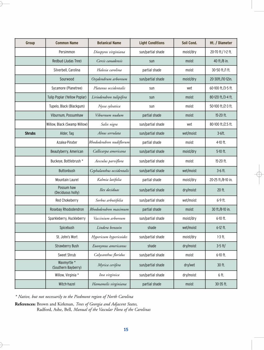
Group Common Name Botanical Name Light Conditions Soil Cond. Ht. / Diameter
Persimmon Diospyros virginiana sun/partial shade moist/dry 20-70 ft./ 1-2 ft.
Redbud (Judas Tree) Cercis canadensis sun moist 40 ft./8 in.
Silverbell, Carolina Halesia carolina partial shade moist 30-50 ft./1 ft.
Sourwood Oxydendrum arboreum sun/partial shade moist/dry 20-30ft./10-12in.
Sycamore (Planetree) Platanus occidentalis sun wet 60-100 ft./3-5 ft.
Tulip Poplar (Yellow Poplar) Liriodendron tulipifera sun moist 80-120 ft./3-4 ft.
Tupelo, Black (Blackgum) Nyssa sylvatica sun moist 50-100 ft./2-3 ft.
Viburnum, Possumhaw Viburnum nudum partial shade moist 15-20 ft.
Willow, Black (Swamp Willow) Salix nigra sun/partial shade wet 80-100 ft./2.5 ft.
Shrubs Alder, Tag Alnus serrulata sun/partial shade wet/moist 3-6ft.
Azalea-Pinxter Rhododendron nudiflorum partial shade moist 4-10 ft.
Beautyberry, American Callicarpa americana sun/partial shade moist/dry 5-10 ft.
Buckeye, Bottlebrush * Aesculus parviflora sun/partial shade moist 15-20 ft.
Buttonbush Cephalanthus occidentalis sun/partial shade wet/moist 3-6 ft.
Mountain Laurel Kalmia latifolia partial shade moist/dry 20-25 ft./8-10 in.
Possum haw (Deciduous holly)
Ilex deciduas sun/partial shade dry/moist 20 ft.
Red Chokeberry Sorbus arbutifolia sun/partial shade wet/moist 6-9 ft.
Rosebay Rhododendron Rhododendron maximum partial shade moist 30 ft./8-10 in.
Sparkleberry, Huckleberry Vaccinium arboreum sun/partial shade moist/dry 6-10 ft.
Spicebush Lindera benzoin shade wet/moist 6-12 ft.
St. John’s Wort Hypericum hypericoides sun/partial shade moist/dry 1-3 ft.
Strawberry Bush Euonymus americanus shade dry/moist 3-5 ft/
Sweet Shrub Calycanthus floridus sun/partial shade moist 6-10 ft.
Waxmyrtle * (Southern Bayberry)
Myrica cerifera sun/partial shade dry/wet 30 ft.
Willow, Virginia * Itea virginica sun/partial shade dry/moist 6 ft.
Witch-hazel Hamamelis virginiana partial shade moist 30-35 ft.
* Native, but not necessarily to the Piedmont region of North Carolina
References: Brown and Kirkman, Trees of Georgia and Adjacent States, Radford, Ashe, Bell, Manual of the Vascular Flora of the Carolinas
1514
Attachment 6 - APPROVED GROUNDCOVERS, TREE & SHRUBS FOR WATERSHED BUFFERS
Group Common Name Botanical Name Light Conditions Soil Cond. Ht. / Diameter
ConiferousTrees Shortleaf Pine Pinus echinata sun/partial shade dry 70-100 ft./2-3 ft.
Virginia Pine Pinus virginiana sun dry 40-70 ft./1-2 ft.
Eastern Red Cedar Juniperus virginiana sun dry/moist 40-60 ft./1-2 ft.
Deciduous Trees Ash, Green Fraxinus pennsylvanica sun moist 60-100 ft./1.5 ft.
Basswood (Linden) Tilia heterophylla sun moist 60-100 ft./ 2-3 ft.
Beech, American Fagus grandifolia sun moist 80-100 ft./3 ft.
Bigleaf Snowbell Styrax grandifolius partial shade moist 20 ft.
Birch, River (Red Birch) Betula nigra sun/partial shade wet 60-80 ft./1-2 ft.
Blackhaw Viburnum prunifolium partial shade moist 20-25 ft.
Buckeye, Painted Aesculus sylvatica partial shade moist/dry 20-25 ft.
Carolina Silverbell Halesia carolina sun/partial shade moist 50-60 ft.
Cherry, Black Prunus serotina sun moist 80 ft./2 ft.
Cottonwood, Eastern(Carolina Poplar)
Populus deltoides sun/partial shade wet1 00 ft./5 ft.
Dogwood, Flowering Cornus florida sun/partial shade moist/dry 30-40 ft./12-18 ft.
Dogwood, Silky Cornus amomum sun/partial shade wet/moist 12 ft.
Elm, Slippery (Red Elm) Ulmus rubra sun moist 70-80 ft./2-3 in.
Fringe Tree Chionanthus virginicus sun/partial shade moist/dry 30 ft.
Hickory, Bitternut Carya cordiformis sun moist 60-80 ft./1-2 ft.
Holly, American Ilex opaca partial shade moist 15-30 ft.
Hornbeam, American (BlueBeech, Ironwood)
Carpinus caroliniana sun/partial shade moist 35 ft./1 ft.
Hornbeam, Hop Ostrya virginiana partial shade dry/moist 35 ft.
Maple, Ash-leaved (Boxelder) Acer negundo sun/partial shade moist/we t30-60 ft./2.5 ft.
Maple, Red Acer rubrum sun moist/dry 60-90 ft./3 ft.
Mulberry, Red Morus rubra sun moist 60 ft./2 ft.
Oak, Southern Red Quercus falcate sun dry 80-100 ft.
Oak, Scarlet Quercus coccinea sun dry 70-80 ft.
Oak, Swamp Chestnut Quercus michauxii sun moist 60-80 ft./2-3 ft.
Oak, Water Quercus nigra sun moist/wet 60-100 ft./2.5 ft.
Oak, White Quercus alba sun/partial shade dry/moist 80-100 ft./3-4 ft.
Oak, Willow Quercus phellos sun moist .90-100 ft./1-2 ft.
Paw Paw Asimina triloba sun/partial shade moist 25 ft./1-2 ft.
watershed6.qxd 8/17/05 1:46 PM Page 38

Mecklenburg County Water Quality ProgramLand Use & Environmental Services Agency
700 N. Tryon Street, Suite 205Charlotte, NC 28202-2236
(704) 336-5500(704) 336-4391 (fax)
http://waterquality.charmeck.org
watershed6.qxd 8/17/05 1:46 PM Page 40