protection against floods of the urban watersheds of sidi thabet … · 2018-10-12 · 1 unité de...
TRANSCRIPT
37
Journal of Mediterranean Ecology vol. 16, 2018Journal of Mediterranean Ecology vol. 16, 2018: 37-49© Firma Effe Publisher, Reggio Emilia, Italy
Protection against floods of the urban watersheds of Sidi Thabet in the lower valley of the Medjerda catchment (Tunisia)
Ahlem Gara1,2, Khouloud Gader2, Donia Jendoubi3, Mohamed Bergaoui1
1 Unité de recherche en Gestion Durable des Ressources en Eau et en Sol (GDRES), High School of Engineering of Medjez el Bab (ESIM), University of Jendouba, Tunisia2 National Agronomic Institute of Tunisia, University of Carthage, Tunisia3 Centre for Development and Environment (CDE), University of Bern, Switzerland
Corresponding author: Ahlem GARA, e-mail address: [email protected]
Keywords: Medjerda_Tunisia, floods, cartography, CAQUOT model, urban hydrology.
Abstract
This paper aims to protect against floods of the area of Sidi Thabet, which is located in the Lower valley of Medjerda catchment in the North of Tunisia and known by its wide variability of runoff between dry and wet seasons, with a diffuse distribution of urban and rural areas and the abundance of undeveloped water courses often causing flooding annoying to people and infrastructure. To identify the area of intervention and to propose the suitable accommodations in these ones, we was based on a refined cartography by using GIS tool, on a detailed hydrological study of the zone of the project, on a statistical analysis of the rainfall data using the statistical software HYFRAN, besides the application of the CAQUOT model to obtain the dimensioning flows of the projected hydraulic equipments. The protection primarily consists on estab-lishing different collectors in the five sub-catchments responsible for channeling and routing the storm water to its natural discharge point and replacing the existent equipments unable to forward the flow with a return period (RT) of twenty years. The nature of the proposed channels depends on the area that they traverse, between buried collectors inside the city to especially solve the problems of water stagnation, open concrete and masonry channels in the towns and cities, and earth channels are projected in the areas non-urbanized in order to minimize the estimated cost of the proposed equipments, instead of respecting the width of the streets while avoiding establishing collectors in the narrow ones.
1. Introduction
Stream networks are majorly influenced by up-stream factors compiled with landscape conditions (Wiens 2002; Burcher 2009) especially urbanization which dramatically alters ecosystem functioning at watershed scale (Groffman et al. 2004; Wollheim et al. 2005; Raciti et al. 2008; Hale et al. 2014). For the natural resource conservation, insightful land management, and the understanding of the ecosystem structure and its function, it’s important to investigate
the landscape-stream (Burcher 2009). Researchers have considered aspects of landscape condition (e.g., land-cover) to be influential determinants of stream re-sponses (Roth et al. 1996; Trimble and Crosson 2000). Multiple argumentations suggest that stream networks are affected by landscape condition especially the anthropogenic disturbance, and their responses are directly related to the type, intensity, and location of landscape disturbance factors (Gupta 1995; Woessner 2000; Gomi et al. 2002; Montgomery and MacDonald 2002; Burcher 2009).

38
Journal of Mediterranean Ecology vol. 16, 2018
Increasing impervious surface area (ISA) from urban and suburban development is a major environ-mental issue largely influencing on hydrology. The increase of ISA impacts watershed hydrology in terms of influencing hydrological processes and causes a series of environmental problems such as soil erosion (Arnold and Gibbons 1996; Zhou et al. 2014).
Peak or flood flow is an important hydrologic pa-rameter in the determination of flood risk, management of water resources and design of hydraulic structures (Abida and Ellouze 2008). This natural phenomena oc-curs at short time scales usually in small basins and it’s considered as the most destructive natural hazard in the Mediterranean region (Gaume et al. 2004; Trambaly et al. 2010). Flood flow estimation must be fairly accurate to avoid excessive costs in the case of overestimation of the flood magnitude or excessive damage and even loss of human lives (Ellouze and Abida 2008).
The majority of the watersheds in the Mediterranean region have a diffuse typology (Gara et al, 2015) and the most urbanized catchments are relatively small and display features (e.g. coefficient of imperviousness, artificial drainage network) that reduce the catchment response time (Fletcher et al. 2013). The heterogeneity of urban land cover, particularly for peri-urban areas, also necessitates models that can represent the contri-butions of distributed sub-catchments to the catchment outlet (Fletcher et al. 2013).
In this context, this paper focuses on the protec-tion of Mediterranean peri-urban watersheds located in the Northern of Medjerda basin in Tunisia from floods which deeply affect these areas basing on a refined cartography of the hydrological behavior of these watersheds and the flow calculated through the CAQUOT model. The paper also proposes suitable hydraulic equipments to be installed after evaluation of the existent equipments capacity and their aptitude faced to extreme floods recorded in the study area.
2. Study area and data
2.1. Study areaThe study area is located in the North-East of
Tunisia within the UTM ranges of coordinates be-tween 589.863-607.130X and 4079.391-4097.709Y, respectively (Fig. 1) and includes two catchments: the catchment of Hessiene with a surface area of 105.93 km², whose discharge system is the sea and the catch-ment of Melah with a surface area of 45.95 km², whose discharge system is the Medjerda Wadi, having a total surface area of 151.88 Km². It is limited in South, West
and East by mountains and in North by the sea and Garâat Ben Ammar, presenting then a very important variation of altitude between 0 and 310 meter. From the hydrographic network and altitudes, we could divide the area into six sub-catchments, such as the catchment of Hessiene is divided into 4 ones whereas that of Maleh is divided into 2 sub-catchments (Gara et al, 2015). The zone of Sidi Thabet - Kalaât Andelous is characterized by a mild climate having two dominant seasons which are the winter and the summer, the case of the Mediterranean countries, with a monthly aver-age temperature of the air between a minimum of 5.9 °C, recorded in February, and a maximum of 33.8 °C recorded in August, for the period between 1981 and 2000, and with a relative humidity varying between a minimum of 64.6% recorded during the summer and 80.44% recorded during the winter. The evapotraspira-tion has the minimum in winter with a value of 29.3 mm/month recorded on December, and and a maximum during the summer with a value of 176.8 mm/month recorded on July, which can imply a water deficit dur-ing the hot season and negatively influence on water reserves (Gara et al, 2015).
The low valley of Medjerda is characterized by fertile soils, therefore, it is priority to know its pedo-logic and geological characteristics as well as the land use system and the urban areas. The region of study is very liable to flooding, principally caused by the urban zones. Indeed, these zones occupy 4.98 % of total area for the two basins and it includes the city of Sidi Thabet , the villages of Sabbelit Ben Ammar, city of Monji Slim, Cherfech and other and other rural areas of 7.567 Km². The other important criterion of this area is the presence of Garâat which constitutes a water stagna-tion with a value of 5.3% of the total area explained by the location of the study watersheds near the sea as well as the weak depth of the underground water. The most remarkable geological forms in the zone are the anticlinal of Jebel Ammar , the monoclinal of Nahli mountain and the synclinal of Mnihla. The majority of the soil texture of the study area is composed by silts and clays with a value approximately 59% from the total catchment area, besides the sandy soils which occupy 36% of entire surface.
2.2. DataThe data used to accomplish this study are com-
posed by cartographic and meteorological data. Con-cerning the cartographic ones, they are essentially topographic maps of the region with a resolution of 1/25000 meters as well as images of Google Earth and the plan of existent equipments, and for the meteoro-

39
Journal of Mediterranean Ecology vol. 16, 2018
logical data used to represent the study area, such as temperature, humidity and evapotranspiration, they are obtained from the station Cherfech CRGR controlled by the National Research Institute for Rural Engineer-ing, Water and Forestry (INRGREF- Tunisia). The re-tained rainfall stations are those of Sidi Thabet, Kalaât Andelous and Cherfech CRGRexisitng in the zone of study. According to The Directorate-General of Water Resources (DGRE-Tunisia), the available data for the three stations are daily, monthly and annual rainfall series for 26 years period, of 1985 to 2010.
3. Methodology
3.1. Hydrological reviewRainfalls fluctuate between the rainy and non-rainy
seasons. It is noticed that winter is the most rainy sea-son. We recorded for the station of Kalaât Andelous a seasonal average rainfall of 219.3 mm whereas for the summer season, it is of 19.3 mm (Fig. 2).
3.2. Statistical analysis of the dataAccording to the coefficients of variance and
asymmetry analysis with a value of 0.3, we can affirm that the data series are homogenous and reliable, and according to the regression parameter R² between the three station, which is near to 1, we can conclude that the three stations are well correlated (Fig. 3).
So, to choose the representative station of the re-gion, we relied on the longest series of available data,
which is the station of Cherfech CRGR, having a continuous series of daily data, for the period 1975-2009.
For a better study of the exceptional floods, we based the analysis on assessing the daily maximum rainfall concentrated in time and in space, by using the software HYFRAN. For the period of 1975-2009, the daily maximum rainfall is about 100. 5 mm and of daily maximum average of 47. 55 mm.
3.3. Calculation of the probable maximal Precipitation (PMP) and the probable maximal flow (PMF)
Probable maximum precipitation (PMP) is defined as ‘the greatest depth of precipitation for a given dura-tion meteorologically possible for a given size storm area at a particular location and at a particular time of year, with no allowance made for long-term climatic
Fig.1 Map of sub-catchments and stream network of the zone of study

40
Journal of Mediterranean Ecology vol. 16, 2018
Fig.2 Mean monthly inter-annual rainfall for the three stations existing in the study area (1985-2010)
Fig.3 Scattered plot of cumulated annual values between the three rainfall stations :(a) Sidi Thabet- Kalaât Andelous, (b) Sidi Thabet - Cherfech CRGR and (c) Cherfech CRGR-Kalaât Andelous for the period (1985-2010)

41
Journal of Mediterranean Ecology vol. 16, 2018
trends’ (WMO 1986; Casas et al. 2010). According to Hershfield et al. (1961), a PMP is resulting from an extremely rare event. It can be calculated according to the statistical method which bases on the analysis of long series of daily maximum rainfall.
Hershfield determined that a given duration the probable maximum rain could be estimated for each station while using the function
Where PMP is the maximum probable precipita-tion, PM is the mean maximum precipitation in inch of water, KM is a factor of frequency to obtain PMP and σ is the standard deviation evaluated using the series of the maximum observed precipitations.
Hydrologists use the PMP magnitude and its spatial and temporal distributions to calculate the probable maximum flood (PMF) (Casas et al. 2010).
The daily PMP for the station of Cherfech CRGR can reach 350 mm for a RT of hundred years, which is an extremely high value and can cause harmful and destructive damages for facilities as well as for in-habitants of the study area, while the maximum daily rainfall noticed for the same hystorical period does not exceed 125 mm.
The PMF is calculated based on the SCS method (Rallison et al. 1981) and the PMP presented by the formulas (2) and (3).
with Q is the flow (m3/s), P is the precipitation (mm), S is the retention of the maximum potential soil mois-ture (mm), Ia is the initial abstraction (mm), where the amount of water dissipated such as by infiltration or interception of the pluviometry by vegetation; and it is generally supposed that Ia = 0.2S, and CN is the curve number.
For our case of study, the Curve Number of the SCS formula is estimated as 80 for a C soil class and then the results of PMP and PMF calculated are presented in Table 1.
It is noticed that PMF for a period return of 50 years in the order of 228 m3/s, which is considered very important that requires a diagnostic of the exist-ent hydraulic equipments in the area to ascertain their capabilities of transit at the time of the uncommon and torrential runoffs.
3.4. Coefficient of streamingTo identify the area of intervention, we were based
on the coefficient of streaming calculated for the six sub-watersheds. This coefficient is obtained using the formula (4)
It is necessary to take account of the impermeable areas, primarily the urban areas whose coefficient of streaming, which is close to 1, is detailed according to the land cover type (Table 2).
Although the coefficient of streaming is low in all sub-watersheds, in the neighborhoods of 0.4, the streaming of rainfall during the floods is the major problem of the study area because of the diffuse ur-banized distribution typology of the sub-watersheds primarily concentrating in the discharge system and the Garâa.
3.5. The CAQUOT methodThe peak output flow is used for the dimensioning
of the various hydraulic equipments as well as to re-
Table 2 Coefficient of streaming of the sub-watersheds (SBW)
Type of land cover Ci SBW1 SBW2 SBW3 SBW4 SBW5 SBW6
Surface of the land cover type
Cities 0.9 - 1.74 24.15 - 38.83 -
Villages 0.7 33.93 - 43.10 - 117.14 3.29
Detached houses 0.55 0.65 - 24.04 13.9 100.05 26.14
Natural 0.4 484.02 211.86 842.51 438.8 3028.48 495.47
Coefficient of streaming - 0.42 0.404 0.443 0.405 0.421 0.315
Table 1 Calculated PMP and PMF
Return period (years) 5 10 20 50 100
PMP (mm) 131.99 175.14 222.83 292.65 350.66
S (mm) 63.5 63.5 63.5 63.5 63.5
PMF (m3/s) 77.86 116.79 161.37 228.19 284.5

42
Journal of Mediterranean Ecology vol. 16, 2018
calibrate the bed of the wadi with an aim of preventing the infrastructures and humans from damages during exceptional floods. The model developed by CAQUOT (Fouquet et al. 1978; Desbordes 1976; Norman 1974) drift from the general method known as “rational formula”.
The model of CAQUOT is based on the conserva-tion of volumes during the time interval θ separating the beginning of the rainfall and the moment of the peak output Qp with the discharge system; its algebraic formulation is presented by the Formula 5:
where H is the height fall during the rainfall to the epicenter of the thunderstorm in mm, Cr is the coef-ficient of streaming, A as the surface of the watershed in ha, α as the coefficient of space abatement of the rain, βtQp is the volume stored during the time of concentration and δθQp as the volume run out with the discharge system since the beginning of the flood.
In addition, the theoretical studies of the flood time on the ground and in the stream network made it possi-ble for CAQUOT to show that the time of concentration depends on the lengthening (E) of the catchment area, of its hydraulic slope I (in m/m), of its surface A (in ha) and of the peak output Qp (in m3/s). (Formula 6)
By issuing the hypothesis considering the length of the torrential rain equal to the time of concentra-tion - with a light overvaluation of the advanced runoff - the combination of the equation of conservation of volumes, of expression of the time of concentration and of the expression of Montana allowed to CAQUOT to establish a relation formulating expressly the advanced runoff with a RTgiven in any point of the stream net-work. (Formula 7)
where Qp is representing the peak flow in m3/s, I represents the hydraulic slope in m/m, C for the coef-ficient of impermeability, m as a corrective coefficient of form and K, α, β, γ as coefficients dependent on the rainfall and the selected period of return.
The Ministry of Equipment’s Bulletin (1977) related to the establishment of the networks of drainage of the urban areas specifies the value of the various param-eters for three French climatic areas. It should be noted that it is possible to determine these multiple coeffi-cients by an analysis of local rainfall by exploitation
of the curved intensities, durations, frequencies (IDF).As for the curve IDF, the maximum average intensi-
ties of a rainfall of duration T, for a period of return T obey the formula of Montana (Formula 8).
where I(T) is considered as the average intensity ( mm/h) of period of return T and duration t, t as the duration of the rainfall episode (hours), T as the RT of the rainfall episode (years); and a and b are regional coefficients in dependence on T
The calculation of the flows is carried out for each under-basin then in each branch of the stream network following a principle of assembly depending on the structure of the network (assembly in series or paral-lel). The resulting flow is recomputed by the formula of CAQUOT (Ministry of Equipment’s Bulletin, 1977) on a basin equivalent to the grouping of these basins.
4. Results and discussion
4.1. Actual situation of the zone of interventionThe area of Sidi Thabet extends on a plain with
relief relatively low. It is limited to the South and South-east, by the solid masses of Djebel Ammar and to the West by Medjerda Wadi.
The problems of floods in the city of Sidi Thabet are recorded primarily on the level of Mrezguia and Stadium like as well as on the level of the cities Monji Slim and El Fellahine.
The water table is not very deep on the level of the cities El Fellahine and Monji Slim, which saturates the soil at the rainy events even for the weak intensi-ties. Historically, the city did not know phenomena of exceptional floods others that those generalized on the totality of the country, but we often attend cuts of roads and points of water stagnations with the least important rain. This situation worsens by the inef-ficiency or even the absence of the infrastructures of evacuation of rain waters.
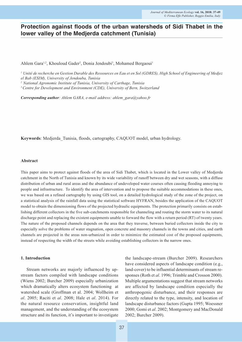
Following the examination of the management plan of the city of Sidi Thabet and after identification of the sub-watersheds, we can extract the flooded areas (fig.4).
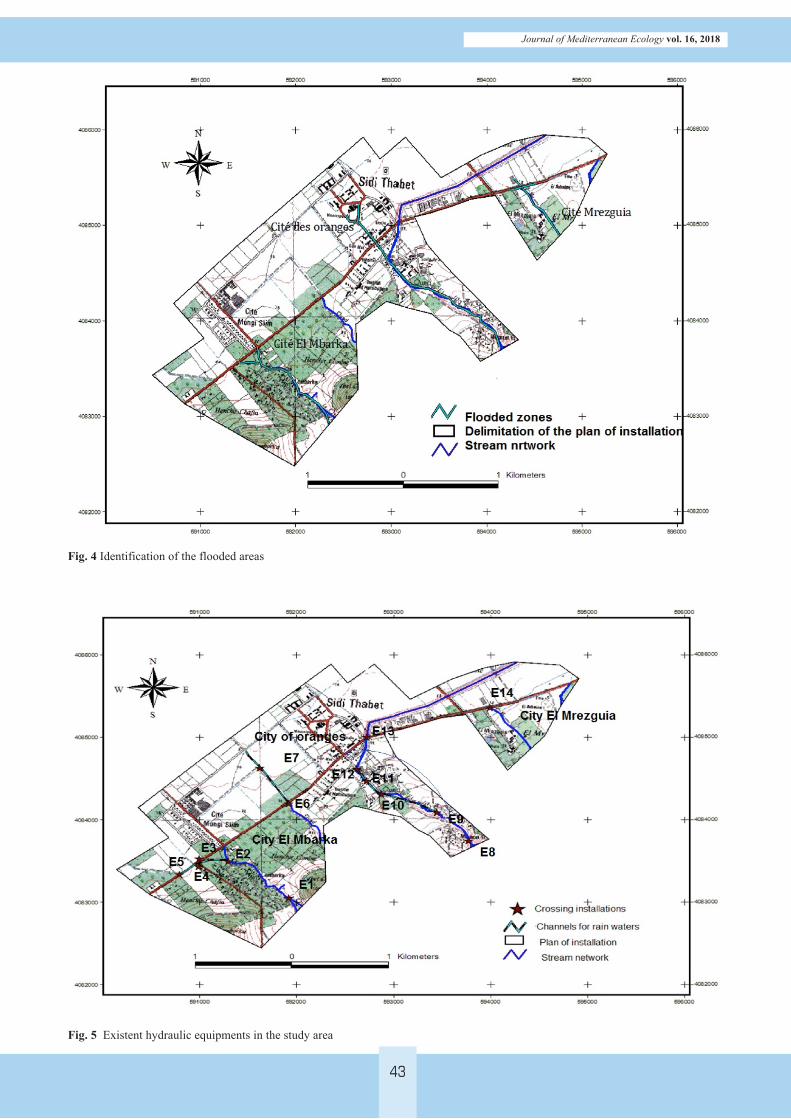
Existing hydraulic equipments in the commune of Sidi Thabet (fig.5), are mainly truss-bridges, nozzles, box culverts, channels and rain pipelines, and which are primarily intended to channel the flows of the abundant waterways in this zone while protecting rural and urban environment. Currently, the maintenance of
43
Journal of Mediterranean Ecology vol. 16, 2018
Fig. 4 Identification of the flooded areas
Fig. 5 Existent hydraulic equipments in the study area

44
Journal of Mediterranean Ecology vol. 16, 2018
these equipments is ensured by the Direction of the Urban Hydraulic. The existing drainage system of rain waters in the city is limited on crossing equipments of which is in majority of times inefficient and badly dimensioned, emerged and silted up.
4.2. Model parametersFirst of all, We have to proceed on delimiting the
basins of influences corresponding to the nodes of calculation (Fig. 6). This cutting depends primarily on topography, then we determines, for each elementary basin, the length of the longest thalweg, the slope, the surface, the coefficient of streaming and the intensity for a period of returns of 20 years starting from curve IDF of the station Cherfech CRGR (Gara et al, 2015)
For each sub-watershed, we calculated the mor-phometric parameters (Table 3) that will be used in the CAQUOT model.
The parameters a and b of the formula of Montana were extracted from the IDF of the used rainfall sta-tion. These coefficients were adapted in order to have an intensity in millimeter per minute and t expressed in minute, the coefficient a is of 10.8 and b of -0.68.
4.3. Comparison between the capacity of existent equipments and the projected flow
For the development of installations and the pro-posal of the alternative solutions, it is necessary to carry out a comparison between the maximum capacity of the existing hydraulic equipments in the study area, which are located in the nodes of assembly, and the peak flow calculated for a 20 years period of return.
It is noticed that the majority of the existing equip-ments are unable to forward the flow of 20 years RT chosen for the proposal of installations for the zone of Sidi Thabet. Referring on the PMF calculated previ-ously, all the equipments are unable to forward the decennial flow. It is noted that the flow obtained by the PMF is the total flow arriving at the zone of study whereas the model of CAQUOT allows the subdivision of this flow according to the sub-watersheds, allowing then more precision in the calculation of dimensioning.
4.4. Proposal of equipments suitable for each areaInstallations to be proposed must satisfy the main
objective of this study, which is the channeling and the preservation of the floods flow within limits not
Fig. 6 Sub-watersheds of the area of Sidi Thabet

45
Journal of Mediterranean Ecology vol. 16, 2018
Table3 Morphometric parameters of the sub-catchments of Sidi Thabet
Sub-watersheds Slope (m/m) Surface (ha) Thalweg (m) Coefficient of streaming (%)
W 1-1 0.071 181.28 1862.5 39%
W 1-2 0.067 95.6 1693.4 47%
W 1-3 0.084 181.68 1671.9 50%
W 1-4 0.057 60.38 1008.4 44%
W 2-1 0.059 107.73 1464 41%
W 2-2 0.079 99.39 1983 50%
W 3-1 0.076 284.88 3639.4 47%
W 3-2 0.066 17.79 813.2 49%
W 3-3 0.021 270.45 1951.1 50%
W 4-1 0.067 153.31 1975.4 49%
W 5-1 0.072 208.74 3113.8 50%
Table 4 Comparison between the capacity of existent equipments and the calculated flows for a return period of 20 years
Equipment Nature Maximal capacity (m3/s) Calculated Flow (Q20)
E1 Nozzle 10 14,212
E2 Box-Culvert(B-C) 28.91 27,681
E3 Trapezoidal Earth Channel (TEC) 10.89 35,838
E4 Trapezoidal Concrete Channel (TCC) 22.12 35,838
E5 Truss bridge (TB) 13.44 38,805
E6 TB 15.46 26,126
E7 TEC 24.75 26,126
E8 B-C 21.12 30,469
E9 Rectangular Masonry Channel (RMC) 18.57 32,267
E10 B-C 18.78 32,267
E11 Rain water Channel 10.5 32,267
E12 B-C 13.54 32,267
E13 TB 42.21 33,060
E14 TB 10.8 30,456
constituting a danger to the population. In the phase of installations proposal, it is important to take into account certain factors which are topography, urbani-zation, the estimated cost of installations, period of return, socio-economic and environmental impact of the selected alternative.
The economic issue is the common constraint for all the projected installations which depends primarily on the period of return chosen, therefore the degree of risk to be prevented, besides the socio-politic consid-erations which characterize each country.
It is noted that the nature of each projected collec-tor depends primarily on the crossed area. We distin-
guish the earth channels for the waterways crossing the non-urban zones and the channels of concrete and masonry for the waterways crossing the cities and the towns (Fig. 7).
Street RL518 constitutes the major problem for the city of Sidi Thabet because of the break of slope as well as the insufficiency and the inefficiency of the drainage network, which led to the prolonged stagna-tion of water and the floods for each important rainfall episode in the zone.
4.4.1. Collector1 C1 (Watershed 1)It is the collector which intercepts the streaming wa-

46
Journal of Mediterranean Ecology vol. 16, 2018
ter coming from the wadi Ben Othmane. The existing nozzle is silted up and under dimensioned. Therefore, it must be replaced by a Box-Culvert (B-C1). This last would lead to a trapezoidal concrete channel (TCC1) which continuous its layout to reach the existent cross-ing equipment (E2) and whose maximal capacity is considered to be adequate compared to the flow of a RT of 20 years. Thereafter, the flow will be arranged with the help of a Trapezoidal Earth Channel (TEC1) emerging on the level of the projected TCC2. The exist-ent truss bridge also should be replaced by a crossing equipment (B-C2).
4.4.2. The dredging of the Hassen Wadi (Watershed 2)Installation consists in preserving the current bed
of the wadi all while giving it a sufficient section to forward the flow of RT of 20 years in the form of a TEC2 and a box-culvert B-C3.
Table 5 Dimensions of Box-Culvert
B-C Number or length Length Width
B-C1 3 2.5 1.3
B-C2 3 2.8 1.5
B-C3 3 2.3 1.3
B-C4 3 2.4 1.4
B-C5 380 m 4 2.2
B-C6 3 2.4 1.5
B-C7 2 2.7 1.6
B-C8 2 2.7 1.7
4.4.3. The collector C3 (Watershed 3)The surface waters of basins W3-1 and W3-2 will
be intercepted distinctly.The latter will be collected by two rectangular
masonry channels (RMC1 and RMC2).The flow of the two channels meet at the time in the
level of the crossing equipment of (B-C4) to set up in order to replace the existing equipment. Construction in the upstream of the city of the Gardens of a drumming equipment must allow a better flow and to stop the solid contributions caused by the streaming in the channels.
From this point, and taking into account the soil type and of the topography, it is essential to replace the under dimensioned rain channel (E11) by a buried channel (B-C5). The flow will be conveyed thereafter by a crossing equipment (B-C6) projected to replace the existing B-C.
Lastly, the arranging of the wadi would be carried out in a TCC3 which will convey the flows until the outlet located at the level of the natural bed of the wadi Ain Zarga.
4.4.4. Collector C4 (Watershed 4)The water collector of El Mrezguia city waterway
requires the installation of a Rectangular Concrete Channel (RCC1) which would skirt the city before crossing the road RL 518 by a crossing equipment (B-C7) intended to replace the existing equipment E14. The bed of the wadi would be arranged thereafter in a TEC3, until its rejection on the level of the channel of the Hessiene wadi.
Table 6 Dimensioning of the collectors
Equipment Narrow base Wide base Height Wet surface (m²)
Wet perimeter (m)
Hydraulic radius(m)
Manning‘s coefficient of rugosity
TCC1 3.5 7.5 2 11 9.15 1.20 70
TEC1 5.7 11.1 2.7 22.68 13.33 1.7 35
TCC2 4 8.4 2.2 13.64 10.22 1.33 70
TEC2 4.6 9.8 2.6 18.72 11.95 1.56 35
RMC1 5.5 2.6 14.3 10.7 1.33 60
RMC2 5.5 2.6 14.3 10.7 1.33 60
TCC3 4 8.2 2.1 12.81 9.93 1.29 70
RCC1 4.5 2.5 11.25 9.5 1.18 70
TEC3 5 10 2.5 18.75 12.07 1.55 35
RCC2 4.6 2.6 11.96 9.8 1.22 70
TEC4 5.2 10.4 2.6 20.28 12.55 1.62 35

47
Journal of Mediterranean Ecology vol. 16, 2018
4.4.5. Collector C5 (Watershed 5)This collector intercepts the flow coming from
the East of the Mrezguia city. This collector will be arranged in a RCC2. The passage on the level of road RL518 is ensured by a B-C8 then a TEC4 which take birth in the level of this crossing until its discharge point on the level of the Hessiene wadi channel.
4.5. DiscussionInstallations to be proposed, especially on the level
of Watersheds 1 and 3, of the wadis Ain Zarga and Ben Othmane, are important of dimensions, requiring the land expropriation in the neighborhoods of the equip-ments intended for derivations of watercourses as well as the destruction of the buildings on both sides of the hydraulic equipments, but this solution remains most logical with the least risk and cost.
In the socio-economic point of view, these instal-lations must satisfy primarily the protection against the floods of the city of Sidi Thabet. This action must also allow the retention of the water collected to be used in the agricultural domain mainly for the irriga-tion. It must also answer the major need which is the non-rupture of the economic activities at the time of
the floods by the immersion of road RL518. Therefore, the aim of this study is to improve the living standard in this area, already going through a remarkable de-velopment these last years in all the fields.
For an environment point of view, the projected installations assist to the maintain of the natural envi-ronmental balance. It is noted that the Wadi Ain Zarga started to cause problems of pollution worsened during the summer because of the humid and warm climate supporting the abundance of the insects impacting the life of the inhabitants of the zone. This problem is the immediate result of the waste water rejection in this waterway.
It is noted that we could propose another plan of installations which consists on the projection of a lake as a hydraulic installation for the upstream retention of the urban areas for the two watersheds, 1 and 3, but this solution is not valid because it is impossible to expropriate the land from the farmers in a very fertile area, the case of our zone of study. So, the proposed installations remained the most efficient solution with the less cost. But this solution is valid for a RT of twenty years, which is not the ideal solution because the study area is exposed to floods with a RT higher
Fig.7 Plan of installation suggested for the protection of the Sidi Thabet city against floods
48
Journal of Mediterranean Ecology vol. 16, 2018
than the one fixed for this case of study, limited by financial resources.
5. ConclusionProtection against the floods of the community
of Sidi Thabet proves to be important and must be immediate after the diagnostic of existing hydraulic equipments.
The proposal of installations was based on the cho-
sen RT, which is twenty years. Therefore, the wanted safety level, by the application of the CAQUOT model. The carried out study showed the need for the replace-ment of the majority of the existing equipments which are unable to forward flows of short RT. The suggested installations was supported on the dimensioning of the collectors and the channels while eliminating the possibility projection of water reservoirs due to the impossibility of land expropriation from the farmers.
References
Abida, H; Ellouze, M. 2008. Probability distribution of flood flows in Tunisia. Hydrol. Earth Syst. Sci 12:703–714
Arnold, C.A.Jr; Gibbons, C.J .1996. Impervious surface coverage: the emergence of a key urban environmental indicator. Journal of the American Planning Association 62(2):243–258
Burcher,C.L .2009. Using simplified watershed hydrology to define spatially explicit ‘zones of influence’. Hydrobio-logia 618:149–160. DOI 10.1007/s10750-008-9572-0
Casas, M.C; Rodriguez, R; Prohom, M; Gazquez, M; Re-dano, A. 2010. Estimation of the probable maximum precipitation in Barcelona (Spain). Int. J. Climatol. DOI: 10.1002/joc.2149
Desbordes, M . 1976. Extension du modèle de CAQUOT aux bassins versants hétérogènes. TSM 5:223-229
Ellouze, M; Abida, H. 2008. Regional Flood Frequency Analysis in Tunisia: Identification of Regional Distribu-tions. Water Resour Manage 22:943–957. DOI 10.1007/s11269-007-9203-y
Fletcher, T.D; Andrieu, H; Hamel,P. 2013. Understanding, management and modeling of urban hydrology and its consequences for receiving waters: A state of the art. Advances in Water Resources 51:261–279
Fouquet, P. 1978. Evacuation des eaux pluviales urbaines. Amicale des Elèves de l’ENPC, Paris
Gara, A; Gader, K; Bergaoui, M. 2015. Hydrologie et aménagement hydraulique de la basse Medjerda. Book of 140 pages published by: Edition des universitaires Européennes. ISBN-13:978-3-8417-4888-1
Gaume, E; Livet, M; Desbordes, M; Villeneuve, J.P .2004. Hydrological analysis of the river Aude, France, flash flood on 12 and 13 November 1999. J. Hydrol. 286:135–154
Gomi, T; Sidle, R.C; Richardson, J.S .2002 . Understand-ing processes and downstream linkages of headwater systems. BioScience 52: 905–916
Groffman, P.M; Law, N.L; Belt, K.T; Band, L.E; Fisher, G.T .2004 .Nitrogen fluxes and retention in urban watershed ecosystems. Ecosystems 7:393–403
Gupta, R.S .1995. Hydrology & hydraulic systems. Pros-pect Heights, III., Waveland Press, Chicago, 739, Call Number: TC145 .G841995
Hale, L; Turnbull, L; Earl, S.R; Childers, D.L; Grimm, N.B. 2014. Stormwater Infrastructure Controls Runoff and Dissolved Material Export from Arid Urban Watersheds Rebecca. Ecosystems. DOI: 10.1007/s10021-014-9812-2
Hershfield, D.M .1961 .Rainfall Frequency Atlas of the United States, U. S. Weather Bureau, Hydrometeorologi-cal Report No. 40, Washington, D. C
Ministry of Equipment’s Bulletin (1977). The technical instructions on urban sewerage networks. CI n° 77.284/INT, Official Bulletin , Paris, 01/12/1977
Montgomery DR. and MacDonald LH (2002) Diagnostic approach to stream channel assessment and monitoring. Journal of the American Water Resources Association 38:1–16
Normand, D .1974 . Ajustement expérimental de la formule de CAQUOT en hydrologie urbaine. La Houille Blanche 4/5:357-360
Raciti, S.M; Groffman, P.M; Fahey, T.J. 2008 . Nitrogen re-tention in urban lawns and forests. Ecol Appl 18:1615–26
Rallison, R.E; Miller, N .1981. Past, present, and future SCS runoff procedure. In V.P. Singh (ed.) Rainfall-Runoff Relationships: Proceedings, International Symposium on Rainfall-Runoff Modeling. Mississippi State Uni-versity:353-364
Roth, N.E; Allan, J.D; Erickson, D.L .1996. Landscape influences on stream biotic integrity assessed at multiple spatial scales. Landscape Ecology 11: 141–156
Tramblay, Y; Bouvier, C; Martin, C; Didon-Lescot, J; To-dorovik, D; Domergue, J. 2010 . Assessment of initial soil moisture conditions for event-based rainfall–runoff modeling. J. Hydrol. 387: 176–187
Trimble, S.W; Crosson, P. 2000. U.S. soil erosion rates: Myths and reality. Science 289: 248–250.
Wiens, J.A. 2002. Riverine landscapes: Taking landscape ecology into the water. Freshwater Biology 47:401–415.
Woessner, W.W. 2000. Stream and fluvial plain ground water interactions: Rescaling hydrogeologic thought. Groundwater 38:423–429

49
Journal of Mediterranean Ecology vol. 16, 2018
Wollheim, W.M; Pellerin, B .A; Vorosmarty, C.J; Hopkinson, C.S. 2005. N retention in urbanizing headwater catch-ments. Ecosystems 8:871–84
World Meteorological Organization .1986. Manual for esti-mation of probable maximum precipitation. Operational hydrology, Report.1. WMO-No.332, 269
Zhou, Y; Wang, y; Gold, A.J; August, P.V; Boving, T.B .2014. Assessing impact of urban impervious surface on watershed hydrology using distributed object-oriented simulation and spatial regression. GeoJournal 79:155–166. DOI 10.1007/s10708-013-9506-x