prt 505 assignment ph - wordpress.com · a pdf source file of the original master plan for the park...
TRANSCRIPT
1
PRT 505 Assignment #1 – Paul Herbert
Evaluating Spatial Information – Bailey Road Park – Cornelius NC
Bailey Road Park encompasses over 66 acres located off Hwy 115 at the corner of Bailey Road in Cornelius North Carolina. The park provides a variety of recreational opportunities and site amenities including two lighted soccer fields, a football field with a running track. There are three lighted tennis courts, as well as two lighted baseball/softball fields and a batting cage. Two picnic shelters with picnic tables, grills and public restrooms are also located on the park site. Other amenities include outdoor basketball courts, nearly two miles of asphalt walking trails, 1/4 mile nature trail, a large band shell, two playground areas and a popular eighteen-hole disc golf course.
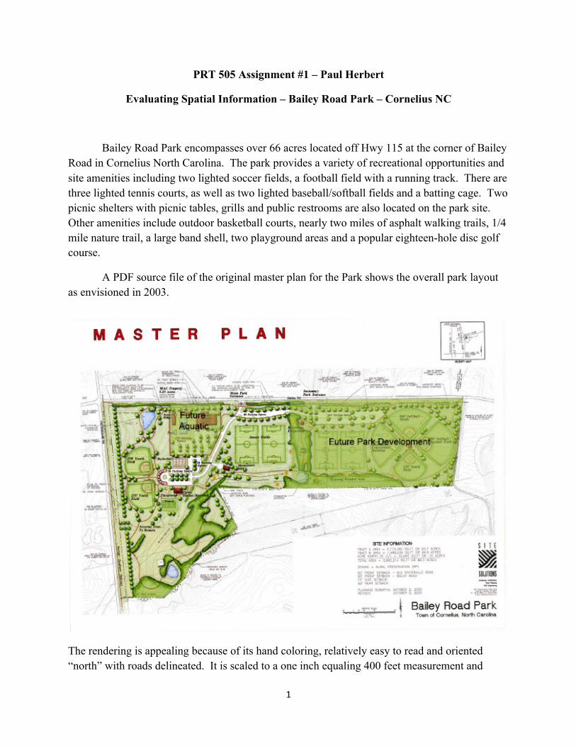
A PDF source file of the original master plan for the Park shows the overall park layout as envisioned in 2003.
The rendering is appealing because of its hand coloring, relatively easy to read and oriented “north” with roads delineated. It is scaled to a one inch equaling 400 feet measurement and

2
contains site information and a road orientation legend. A closer view of one of the active areas provides symbolized landscaping, a power easement right of way, field dimensions and information on park amenities in that area such as the number of parking spaces, trail and rest room location. It is oriented to communicate basic park features. I am selecting the ball fields and general turf condition around the ball fields as park features to analyze. The scale as mentioned is 1:400 and resolution is certainly viable up to 400% of the viewing area (PDF viewer). As it is a designed map for site layout purposes it provides no information on the turf except the overall acreage information. The ball fields are drawn to scale and text information is added identifying them as youth fields. The data completeness and data quality are sufficient to gauge the number of fields, dimensions and layout within the park. Metadata information is not available. The rendering is complete with some inaccuracies in layout but is highly user-friendly in providing the viewer with the layout of the park and where these two elements exist within it. There is, however no information on turf quality.

3
The next data map is a Mecklenburg County GIS dataset on a 1:458 foot scale.
4
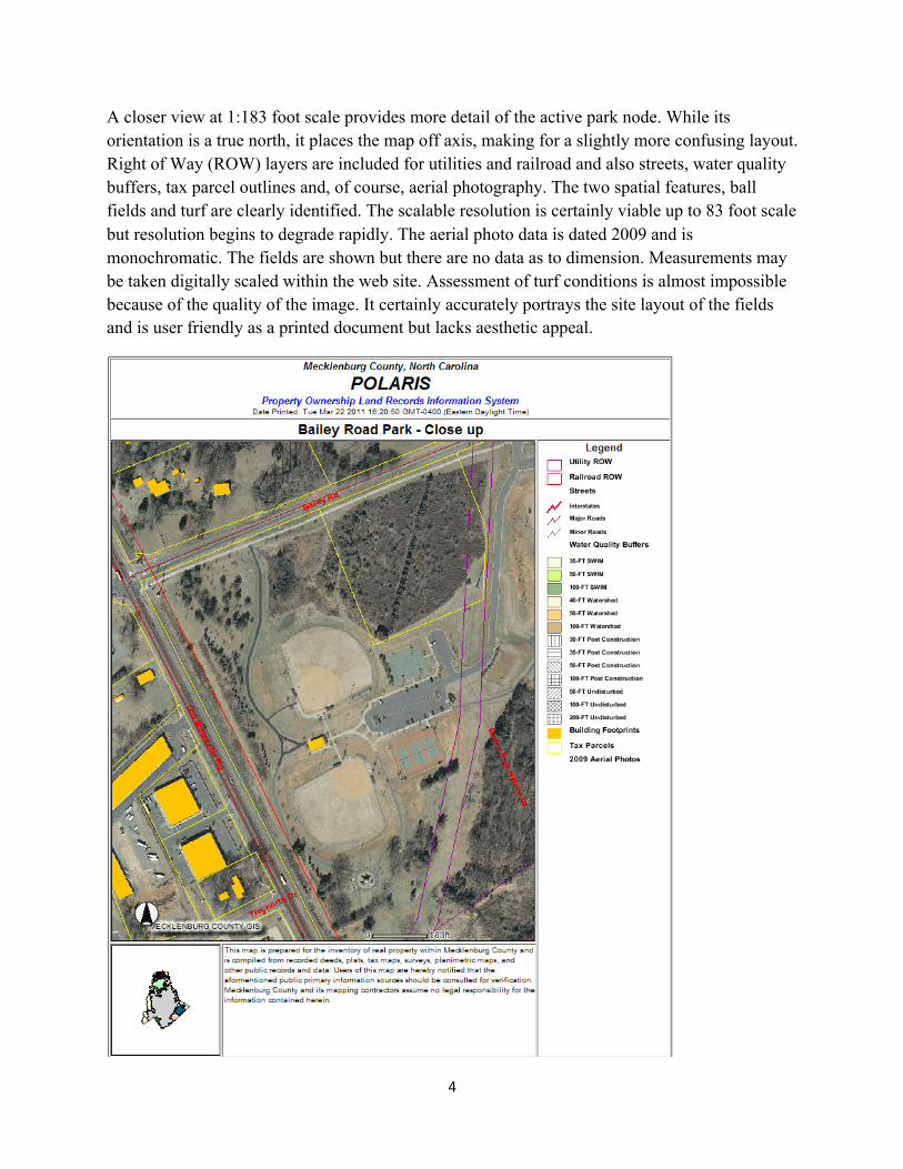
A closer view at 1:183 foot scale provides more detail of the active park node. While its orientation is a true north, it places the map off axis, making for a slightly more confusing layout. Right of Way (ROW) layers are included for utilities and railroad and also streets, water quality buffers, tax parcel outlines and, of course, aerial photography. The two spatial features, ball fields and turf are clearly identified. The scalable resolution is certainly viable up to 83 foot scale but resolution begins to degrade rapidly. The aerial photo data is dated 2009 and is monochromatic. The fields are shown but there are no data as to dimension. Measurements may be taken digitally scaled within the web site. Assessment of turf conditions is almost impossible because of the quality of the image. It certainly accurately portrays the site layout of the fields and is user friendly as a printed document but lacks aesthetic appeal.

5
A Google Earth image map of the same area (truncated here to fit) contains more recent (April 2010) aerial photography, latitude and longitude information, a spectacular “flight simulator that allows the viewer to manipulate, measure and identify features such as erosion, mowing and other details.
There is plenty of information and ability to manipulate scale and the photographic resolution is better (than the GIS server version). Again, no data on the fields is provided beyond the visual placement and location within the park. The user-friendliness of Google Earth can be daunting at times but a rewarding experience. Turf conditions are dramatically pronounced to illustrate erosion and drought conditions, use patterns and landscape areas.

6
Google Maps provides less functionality than Google Earth. It is less spectacular but has features such as traffic integration and navigational elements.
The mapping experience is superior as a digital interface with scale and resolution being as accurate as Google Earth (GE). It does not have the “flight” capacity or historic time capture information built in as does its big brother, GE. Ball field data is identical however as is the identification of turf conditions. It is geared towards directional use and provides parks information in the aerials to provide it as a landmark location. At the elementary level it is helpful but contains no information about the fields other than visual data. It is very user friendly to manipulate the site information and orientation. This would not be the tool of choice for certain users such as parks professionals.
7
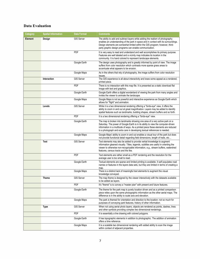
Data Evaluation
Category Spatial Information Data Format Comments
Element Design GIS Server The ability to add and subtract layers while adding the realism of photography enables an understanding of the park in space and in context with its surroundings. Design elements are somewhat limited within the GIS program; however, third-party graphic design programs can enable communication.
PDF It is very easy to read and understand and well accomplishes its primary purpose. Features are well labeled and a vicinity map indicates its location in the community. It is hand colored to represent landscape elements.
Google Earth The design uses photography and is greatly informed by point of view. The image suffers from color resolution which contrasts more sparse grass areas to accentuate what appears to be erosion.
Google Maps As in the others that rely of photography, the image suffers from color resolution issues.
Interaction GIS Server The GIS experience is all about interactivity and loses some appeal as a rendered, printed piece.
PDF There is no interaction with this map file. It is presented as a static download flat image with text and graphics.
Google Earth Google Earth offers a digital wonderland of viewing the park from many angles and invites the viewer to animate the landscape.
Google Maps Google Maps is not as powerful and interactive experience as Google Earth which allows for "flight" and animation.
Levels GIS Server While it is a two dimensional rendering offering a "birds-eye" view, it offers the ability to zoom in and out at great magnification. Layers may be added to identify spatial features such as landmarks, building shapes, stream buffers and so forth.
PDF It is a two dimensional rendering offering a "birds-eye" view.
Google Earth The map is broken into landmarks showing one area of a very active park on a Saturday. The power of Google Earth is in its ability to view the computer-driven information in a multitude of ways. As a printed piece these elements are reduced to a photograph and extra care in developing textual references is needed.
Google Maps Google Maps' ability to zoom in and out enables a visual tour of the park but does not provide functional detail regarding field dimensions, length of trails, etc…
Text GIS Server Text elements may also be added to provide verbal knowledge to augment information gleaned visually. Titles, legends, subtitles are useful in orienting the viewer to otherwise non-recognizable information, e.g., stream buffers, watershed features, census tracts and the like.
PDF Text elements are rather small as a PDF rendering and the resolution for the average user is too small to read.
Google Earth Textual elements are sparse and limited printing is available. It self populates road names or features in the layers data sets, but they are limited in terms of creating a map.
Google Maps There is a distinct lack of meaningful text elements to augment the visual knowledge conveyed.
Theme GIS Server The map theme is designed by the viewer interactively with the datasets available to be added as layers.
PDF It's "theme" is to convey a "master plan" with present and future features.
Google Earth The theme for the park map is purely location driven and as a printed comparison piece relies upon the same photographic information as the other aerial maps. The difference is in the ability to scale axis and elevation.
Google Maps The park is themed for orientation and direction to the location- not so much for purposes of conveying park features, history of other information.
Type GIS Server When not using aerial photo layers, objects are rendered as points, dashes, lines and other symbols providing complex two dimensional renderings.
PDF It is essentially a line drawing with colored polygons.
Google Earth It has topographic elements in addition to photographic. The addition of animation offers a time reference.
Google Maps It is a scalable two dimensional rendering with added ability to scan the image within context of adjacent properties.
8
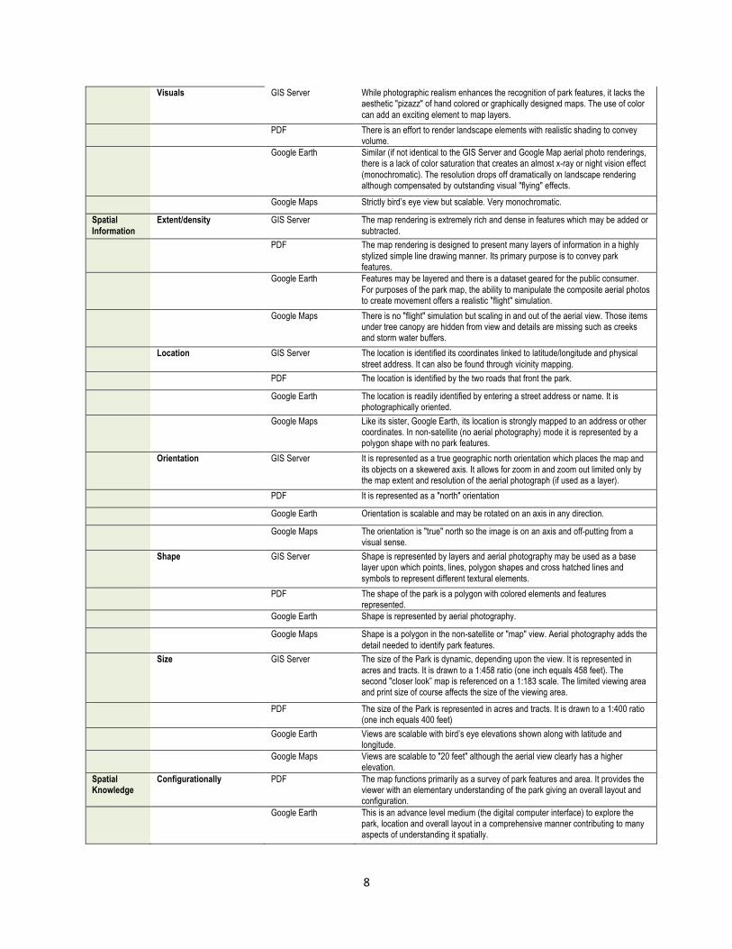
Visuals GIS Server While photographic realism enhances the recognition of park features, it lacks the aesthetic "pizazz" of hand colored or graphically designed maps. The use of color can add an exciting element to map layers.
PDF There is an effort to render landscape elements with realistic shading to convey volume.
Google Earth Similar (if not identical to the GIS Server and Google Map aerial photo renderings, there is a lack of color saturation that creates an almost x-ray or night vision effect (monochromatic). The resolution drops off dramatically on landscape rendering although compensated by outstanding visual "flying" effects.
Google Maps Strictly bird’s eye view but scalable. Very monochromatic.
Spatial Information
Extent/density GIS Server The map rendering is extremely rich and dense in features which may be added or subtracted.
PDF The map rendering is designed to present many layers of information in a highly stylized simple line drawing manner. Its primary purpose is to convey park features.
Google Earth Features may be layered and there is a dataset geared for the public consumer. For purposes of the park map, the ability to manipulate the composite aerial photos to create movement offers a realistic "flight" simulation.
Google Maps There is no "flight" simulation but scaling in and out of the aerial view. Those items under tree canopy are hidden from view and details are missing such as creeks and storm water buffers.
Location GIS Server The location is identified its coordinates linked to latitude/longitude and physical street address. It can also be found through vicinity mapping.
PDF The location is identified by the two roads that front the park.
Google Earth The location is readily identified by entering a street address or name. It is photographically oriented.
Google Maps Like its sister, Google Earth, its location is strongly mapped to an address or other coordinates. In non-satellite (no aerial photography) mode it is represented by a polygon shape with no park features.
Orientation GIS Server It is represented as a true geographic north orientation which places the map and its objects on a skewered axis. It allows for zoom in and zoom out limited only by the map extent and resolution of the aerial photograph (if used as a layer).
PDF It is represented as a "north" orientation
Google Earth Orientation is scalable and may be rotated on an axis in any direction.
Google Maps The orientation is "true" north so the image is on an axis and off-putting from a visual sense.
Shape GIS Server Shape is represented by layers and aerial photography may be used as a base layer upon which points, lines, polygon shapes and cross hatched lines and symbols to represent different textural elements.
PDF The shape of the park is a polygon with colored elements and features represented.
Google Earth Shape is represented by aerial photography.
Google Maps Shape is a polygon in the non-satellite or "map" view. Aerial photography adds the detail needed to identify park features.
Size GIS Server The size of the Park is dynamic, depending upon the view. It is represented in acres and tracts. It is drawn to a 1:458 ratio (one inch equals 458 feet). The second "closer look” map is referenced on a 1:183 scale. The limited viewing area and print size of course affects the size of the viewing area.
PDF The size of the Park is represented in acres and tracts. It is drawn to a 1:400 ratio (one inch equals 400 feet)
Google Earth Views are scalable with bird’s eye elevations shown along with latitude and longitude.
Google Maps Views are scalable to "20 feet" although the aerial view clearly has a higher elevation.
Spatial Knowledge
Configurationally PDF The map functions primarily as a survey of park features and area. It provides the viewer with an elementary understanding of the park giving an overall layout and configuration.
Google Earth This is an advance level medium (the digital computer interface) to explore the park, location and overall layout in a comprehensive manner contributing to many aspects of understanding it spatially.

9
Declarative GIS Server At the elementary level. the map is designed to provide basic information, primarily relying upon the aerial photography to convey park features (ball fields, overall shape, street location),
Procedural/Configurational Google Maps Google Maps is designed to enable a person to travel a route using distance and direction. It also is "configurational" in helping a person understand the overall layout and configuration of the park.