pu†ukohol heiau national historic site
TRANSCRIPT
National Park Service U.S. Department of the Interior Natural Resource Stewardship and Science
Vegetation Inventory Project Pu‘ukoholā Heiau National Historic Site Natural Resource Report NPS/PUHE/NRR—2011/459

ON THE COVER Pu‘ukoholā Heiau (Temple on the Hill of the Whale) Photograph by: Dan Cogan

Vegetation Inventory Project Pu‘ukoholā Heiau National Historic Site Natural Resource Report NPS/PUHE/NRR—2011/459
Dan Cogan Cogan Technology, Inc. 21 Valley Road Galena, IL 61036 Keith Schulz NatureServe 4001 Discovery, Suite 2110 Boulder, CO 80303 David Benitez National Park Service Hawai‘i Volcanoes National Park – Resource Management PO Box 52 Hawaii National Park, HI 96718 Greg Kudray National Park Service Pacific Island Network – Inventory and Monitoring PO Box 52 Hawaii National Park, HI 96718 Alison Ainsworth National Park Service Pacific Island Network – Inventory and Monitoring PO Box 52 Hawaii National Park, HI 96718
September 2011 U.S. Department of the Interior National Park Service Natural Resource Stewardship and Science Fort Collins, Colorado

ii
The National Park Service, Natural Resource Stewardship and Science office in Fort Collins, Colorado publishes a range of reports that address natural resource topics of interest and applicability to a broad audience in the National Park Service and others in natural resource management, including scientists, conservation and environmental constituencies, and the public.
The Natural Resource Report Series is used to disseminate high-priority, current natural resource management information with managerial application. The series targets a general, diverse audience, and may contain NPS policy considerations or address sensitive issues of management applicability.
All manuscripts in the series receive the appropriate level of peer review to ensure that the information is scientifically credible, technically accurate, appropriately written for the intended audience, and designed and published in a professional manner. This report received informal peer review by subject-matter experts who were not directly involved in the collection, analysis, or reporting of the data.
Views, statements, findings, conclusions, recommendations, and data in this report do not necessarily reflect views and policies of the National Park Service, U.S. Department of the Interior. Mention of trade names or commercial products does not constitute endorsement or recommendation for use by the U.S. Government.
This report is available from NPS Inventory and Monitoring, Pacific Island Network (http://science.nature.nps.gov/im/uites/pacn/index.cfm) and the Natural Resource Publications Management website (http://www.nature.nps.gov/publications/nrpm/).
Please cite this publication as:
Cogan, D., K. Schulz., D. Benitez, G. Kudray, and A. Ainsworth 2011. Vegetation inventory project: Pu‘ukoholā Heiau National Historic Site. Natural Resource Report NPS/PUHE/NRR—2011/459. National Park Service, Fort Collins, Colorado.
NPS 454/110578, September, 2011

iii
Contents Page
Figures............................................................................................................................................. v
Tables ............................................................................................................................................ vii
Appendices ..................................................................................................................................... ix
Executive Summary ....................................................................................................................... xi
Acknowledgments......................................................................................................................... xii
Introduction ..................................................................................................................................... 1
National Vegetation Inventory Program .................................................................................. 1
National Vegetation Classification Standard ........................................................................... 2
Pacific Island Network, Inventory and Monitoring Program .................................................. 4
Pu‘ukoholā Heiau National Historic Site ................................................................................ 5
Vegetation Inventory Project ................................................................................................. 13
Scope of Work ....................................................................................................................... 14
Methods......................................................................................................................................... 17
Planning, Data Gathering and Coordination .......................................................................... 17
Field Surveys ......................................................................................................................... 19
Vegetation Classification ....................................................................................................... 21
Digital Imagery and Mapping ................................................................................................ 27
Accuracy Assessment ............................................................................................................ 30
Results ........................................................................................................................................... 35
Vegetation Classification ....................................................................................................... 35
Vegetation Map ..................................................................................................................... 39
Accuracy Assessment ............................................................................................................ 45
Discussion ..................................................................................................................................... 49

iv
Contents (continued) Page
Page Field Survey .................................................................................................................. 49
Classification ......................................................................................................................... 50
Digital Imagery and Mapping ................................................................................................ 51
Accuracy Assessment ............................................................................................................ 51
Future Recommendations ...................................................................................................... 51
Research Opportunities .......................................................................................................... 52
Literature Cited ............................................................................................................................. 55

v
Figures Page
Figure 1. The 11 national parks included within the Pacific Island Network. ............................... 4
Figure 2. NPS Pu‘ukoholā Heiau National Historic Site map. ...................................................... 6
Figure 3. PUHE entrance and Pu‘ukoholā Heiau (top) and visitor center building (bottom)........................................................................................................................................... 7
Figure 4. Beach strand and basalt outcrop exposed adjacent to the Pacific Ocean within PUHE. .................................................................................................................................. 8
Figure 5. 3D overview image of PUHE and surrounding areas showing common vegetation patterns. ....................................................................................................................... 10
Figure 6. Representative cross-section of PUHE’s topography showing general vegetation life zones. .................................................................................................................... 11
Figure 7. Common vegetation types at PUHE and surrounding areas......................................... 12
Figure 8. The vegetation mapping project boundary and PUHE park boundary. ........................ 15
Figure 9. Field plot data collection at PUHE led by PACN. ....................................................... 19
Figure 10. Location of vegetation plots and observation points collected at PUHE. .................. 22
Figure 11. Distribution of 15 cluster analysis plot groups defined from West Hawai‘i parks using Nonmetric Multidimensional Scaling (NMS) ordination. ......................................... 26
Figure 12. Distribution of 15 cluster analysis plot groups defined from West Hawai‘i parks using Detrended Correspondence Analysis (DCA) ordination. .......................................... 26
Figure 13. Examples of the Ikonos 2002 and Quickbird 2006 imagery for PUHE. .................... 28
Figure 14. Accuracy assessment field data collection at PUHE. ................................................. 32
Figure 15. Location of accuracy assessment points collected at PUHE. ..................................... 34
Figure 16. Example of the PUHE vegetation map layer. ............................................................. 44


vii
Tables Page
Table 1. Summary of USNVC Revised Hierarchy Levels and Criteria for Natural Vegetation. ...................................................................................................................................... 3
Table 2. Plot Sizes Used for Classification Sampling at PUHE. ................................................. 20
Table 3. Cover classes and vegetation strata. ............................................................................... 20
Table 4. Conversion of strata from original data to final stratum used in analyses. .................... 23
Table 5. Names of 15 groups defined by the cluster analysis of West Hawai‘i parks plots with number of plots per groups. ......................................................................................... 25
Table 6. Indicator species with the highest Observed Indicator Values. ..................................... 25
Table 7. Polygon attribute items and descriptions used in the PUHE GIS coverage. .................. 30
Table 8. NVIP Sampling protocol for AA points......................................................................... 31
Table 9. Summary Plant Associations and Park Specials for West Hawai‘i parks with number of plots sampled. .............................................................................................................. 36
Table 10a. PUHE vegetation classification with rUSNVC hierarchy to Group level. ................ 37
Table 10b. Additional vegetation types identified and mapped at PUHE, but not sampled with field plots. ............................................................................................................... 38
Table 11. Map classes and relationships to plant associations and other map units. ................... 40
Table 12. Summary statistics for the PUHE map class polygons. ............................................... 42
Table 13. Sample Contingency Table for PUHE. ........................................................................ 46
Table 14. Population Contingency Table for PUHE. ................................................................... 46


ix
Appendices Page
Appendix A: PUHE Field Data Forms ............................................................................... APP A.1
Appendix B: Plant Species Found within Sample Plots at Pu‘ukoholā Heiau National Historic Site .......................................................................................................... APP B.1
Appendix C: Field Plot Crosswalk to Revised US National Vegetation Classification Associations ................................................................................................. APP C.1
Appendix D: Field Key to the Vegetation of Pu‘ukoholā Heiau National Historic Sites, Hawai‘i ...................................................................................................................... APP D.1
Appendix E: Plant Association Descriptions for Pu‘ukoholā Heiau National Historic Site, Hawai‘i........................................................................................................... APP E.1
Appendix F: Mapping Conventions and Visual Key ........................................................... APP F.1
Appendix G: Final PUHE Vegetation Map ........................................................................ APP G.1


xi
Executive Summary Pu‘ukoholā Heiau National Historic Site (PUHE) encompasses approximately 32 ha (80 ac) on the western coast of the island of Hawai‘i. The park was established to preserve and protect three important ancient Hawaiian heiau or temples and other historical and cultural features. PUHE is situated on a vast lava field supporting 104 vascular plant species including examples of coastal strand and wetland native plants that are actively managed (NPS undated). Most of the remaining vegetation has been extremely altered over the years and consists primarily of non-native buffelgrass (Cenchrus ciliaris = Pennisetum ciliare) and kiawe (Prosopis pallida) trees/shrubs. To better understand the distribution of the plant assemblages located on this site, the National Park Service (NPS) Pacific Island Network (PACN) Inventory and Monitoring Program (I&M) started a vegetation inventory effort at PUHE in 2007. A three-year, four phase program was initiated to complete the task of mapping and classifying the vegetation at PUHE. Phase one conducted by PACN staff in 2008, collected 15 field plots and 13 observation points. In phase two, NatureServe’s Western Regional Office used this field data in conjunction with data collected at two other parks to classify six new plant associations for PUHE based on the revised US National Vegetation Classification (rUSNVC). Phase three, directed by Cogan Technology, Inc (CTI), produced a digital vegetation map and supporting accuracy assessment (AA) materials. In the final phase, PACN staff collected 57 accuracy assessment points in 2010 used to check and finalize the map. To produce the spatial database and map layer, 2006 0.6-meter, 4-band Quickbird satellite imagery was provided by PACN. By comparing the signatures on the imagery to field and ground data, 31 map units (14 vegetated, five geologic, and 12 land-use/land-cover) were developed and directly crosswalked or matched to their corresponding rUSNVC plant associations. The interpreted and remotely sensed data were converted to Geographic Information System (GIS) databases and maps were printed, field tested, reviewed, and revised. The final map layer was accessed for thematic accuracy by overlaying 57 independent accuracy assessment points. The final overall accuracy of the map layer was determined to be 97% with a Kappa value of 82% Products developed for PUHE are described and presented in this report, as well as stored on the accompanying DVD. These include: • A Final Report that includes keys to the vegetation and imagery signatures, AA information,
and all of the project methods and results; • A Spatial GIS Database containing spatial data for the vegetation, plots, and AA points; • Digital Photos from the field sampling efforts; • Metadata for all spatial data (Federal Geographic Data Committee -compliant); • Vegetation Descriptions and Photo Signature Key to the map classes and
associations/alliances. Please access the following website for posting of this information: http://biology.usgs.gov/npsveg/index.html.


xiii
Acknowledgments The production of this vegetation inventory for an important cultural and historic site required the enthusiasm and energy of many people over several years. The authors gratefully acknowledge the dedication of all involved in the production of this report. We would like to specifically thank Penny Latham with the Pacific West Region Inventory and Monitoring Program and Julie Christian, Corie Yanger, Kelly Kozar, Sandy Margriter and all the staff at the Pacific Island Network (PACN) Inventory and Monitoring Program (I&M) for their support and assistance with contracting, work flow, and technical review through all aspects of this project. In addition we would like to acknowledge Viet Doan (formerly with PACN) for his assistance with GIS data acquisition, map creation and general support. We would also like to thank Marion Reid and Jim Drake with NatureServe. Marion was the NatureServe project manager for the Pu‘ukoholā Heiau National Historic Site project and Jim analyzed data for the classification and wrote the vegetation community descriptions. We are grateful to the staff at Pu‘ukoholā Heiau National Historic Site, especially Ben Saldua, who went out of his way to assist with field checking the map, assisting the field crews and providing expert advice. They were very professional and extremely helpful throughout the process. Special recognition goes to Karl Brown with NPS for prioritizing the need for this project and providing funding. Without the financial support from the NPS Vegetation Inventory Program the project would not have been possible.


1
Introduction National Vegetation Inventory Program The National Vegetation Inventory Program (NVIP) was started as a cooperative effort between the National Park Service (NPS) and the United States Geological Survey (USGS) to classify, describe, and map existing vegetation communities in more than 270 national parks across the United States. The primary objective of the NVIP is to produce high-quality plant community classifications, standardized maps and associated data sets of the vegetation currently occurring within the parks. This information fills data gaps and complements a wide variety of resource assessments, park management, and conservation needs. Among its many uses, the NVIP products have helped park managers better identify and conserve plant biodiversity; manage non-native and rare species, monitor insect and disease effects; and provide a baseline to examine wildlife habitat relationships and the effects of wildland fires. In 1999, the Director of the NPS approved the Natural Resource Challenge to encourage national parks to focus on the preservation of the nation’s natural heritage through science, natural resource inventories, and expanded resource monitoring. The Natural Resource Challenge provided funding for 12 baseline inventories to be completed in each of 270 parks with significant natural resources. The vegetation mapping inventory is considered one of these 12 baseline inventories. NVIP follows well-established procedures that are compatible with other agencies and organizations. The inventory uses the USNVCv1, a system that is integrated with the major scientific efforts in the taxonomic classification of vegetation, and is a Federal Geographic Data Committee (FGDC) standard. In addition, stringent quality control procedures ensure the reliability of the vegetation data and encourage the use of resulting maps, reports, and databases at multiple scales. A complete vegetation mapping project for a park includes the following products:
• Detailed vegetation report • Digital vegetation map • Vegetation plot data • Accuracy assessment data and analysis • Dichotomous vegetation key • Photo-interpretation key
Maps are produced in Universal Transverse Mercator (UTM) coordinates (NAD 83) with a 1:24,000 scale and a minimum mapping unit of 0.5 ha (1.2 ac). The vegetation maps must meet the National Map Accuracy Standards for positional accuracy, and the minimum class accuracy goal across all vegetation and land cover classes of 80 percent.
2
National Vegetation Classification Standard In 1994, NPS formed the NVIP to inventory and map the vegetation in the United States National Parks. Shortly thereafter, the USGS joined into a partnership, which continues to operate today. The goals of this program are to provide baseline ecological data for park resource managers, obtain data that can be examined in a regional and national context, and provide opportunities for future inventory, monitoring, and research activities. In the same year, the NVIP also adopted the U.S. National Vegetation Classification (USNVC) (Grossman et al. 1998) as a basis for the a priori definition of vegetation units to be inventoried. The USNVC has since been revised by NatureServe and in 2008 the FGDC formally endorsed the National Vegetation Standard, Version 2 (NVCSv2) (FGDC 2008). Use of a standardized vegetation classification system, such as the NVCSv2 helps ensure data compatibility throughout the NPS and other agencies (FGDC 2008). This is critical for a systematic inventory and classification of the nation’s biological resources to foster efficient stewardship and prioritize conservation efforts. The revised US National Vegetation Classification (rUSNVC) is being used for vegetation classification and mapping projects at Pu‘ukoholā Heiau National Historic Site (PUHE) and other Pacific Island Inventory and Monitoring Network (PACN) parks. It evolved from the original USNVC, which was developed jointly by The Nature Conservancy (TNC), NatureServe, and the Natural Heritage Program network over more than two decades (TNC and ESRI 1994a, Grossman et al. 1998) and adopted in part by the FGDC (1997).
The NVCSv2 is a hierarchical system that allows for vegetation classification at multiple scales (FGDC 2008). There are eight levels with specific criteria set for each level (Table 1). The upper three levels are based on climate and physiognomic characteristics that reflect geographically widespread (global) topographic and edaphic factors. The middle three levels focus largely on broad sets of diagnostic plant species and habitat factors along regional-to-continental topographic, edaphic, and disturbance gradients. These middle levels have been drafted and are undergoing peer review. The lower two levels, as in the original NVC, are the alliance and association and are distinguished by differences in local floristic composition. The broader alliances are physiognomically distinct groups of plant associations sharing one or more differential or diagnostic species (Mueller-Dombois and Ellenberg 1974). These are commonly the dominant(s) found in the uppermost strata of vegetation. The plant association is the fundamental base unit of the classification, and following the International Botanical Congress of 1910, is defined as a community of definite floristic composition (i.e., a repeating assemblage of species), uniform physiognomy and habitat conditions (Mueller-Dombois and Ellenberg 1974).
The rUSNVC is maintained by NatureServe and the network of affiliated Natural Heritage Programs and Conservation Data Centers for use by government agencies and the public (Faber-Langendoen et al. 2009). The rUSNVC database allows for tracking of vegetation at all scales and provides narrative descriptions of many alliances and associations (Faber-Langendoen et al. 2009). Descriptions of MacroGroups and Groups are being written in three phases. Phase one descriptions are currently undergoing peer review (Faber-Langendoen et al. 2010). The content of this database is available to the public and is regularly updated through NatureServe Explorer (http://www.natureserve.org/explorer).

3
Table 1. Summary of USNVC Revised Hierarchy Levels and Criteria for Natural Vegetation.
Hierarchy Level Criteria Upper: Physiognomy plays a predominant role
L1 – Formation Class Broad combinations of general dominant growth forms that are adapted to basic temperature (energy budget), moisture, and substrate/aquatic conditions.
L2 - Formation Subclass
Combinations of general dominant and diagnostic growth forms that reflect global macroclimatic factors driven primarily by latitude and continental position, or that reflect overriding substrate/aquatic conditions.
L3 – Formation Combinations of dominant and diagnostic growth forms that reflect global macroclimatic factors as modified by altitude, seasonality of precipitation, substrates, and hydrologic conditions.
Mid: Floristics and physiognomy play predominant roles
L4 – Division
Combinations of dominant and diagnostic growth forms and a broad set of diagnostic plant species that reflect biogeographic differences in composition and continental differences in mesoclimate, geology, substrates, hydrology, and disturbance regimes.
L5 – Macrogroup
Combinations of moderate sets of diagnostic plant species and diagnostic growth forms, that reflect biogeographic differences in composition and sub-continental to regional differences in mesoclimate, geology, substrates, hydrology, and disturbance regimes.
L6 – Group
Combinations of relatively narrow sets of diagnostic plant species (including dominants and co-dominants), broadly similar composition, and diagnostic growth forms that reflect regional mesoclimate, geology, substrates, hydrology and disturbance regimes.
Lower: Floristics plays a predominant role
L7 – Alliance Diagnostic species, including some from the dominant growth form or layer, and moderately similar composition that reflect regional to subregional climate, substrates, hydrology, moisture/nutrient factors, and disturbance regimes.
L8 – Association Diagnostic species, usually from multiple growth forms or layers, and more narrowly similar composition that reflect topo-edaphic climate, substrates, hydrology, and disturbance regimes.
Associations are generally the same as the original USNVCv1, although revisions have begun in certain areas such as PACN projects. Substantial revisions of the alliances have begun and will continue in the future. PUHE alliances have been reviewed and revised for this project and NatureServe will continue alliance review and revision as other PACN vegetation inventory projects are completed. Although NatureServe’s documentation of vegetation alliances and associations is the most accessible national listing, the data within the USNVC are not complete, and projects such as this one constantly add to the documentation and listing of USNVC types. USNVCv1 associations and alliance are commonly used for vegetation inventory projects. Their use within the NVIP facilitates effective resource stewardship by ensuring compatibility and widespread use of the information throughout the NPS as well as by other federal and state agencies. These vegetation maps and associated information support a wide variety of resource assessment, park management, and planning needs. In addition they can be used to provide a structure for framing and answering critical scientific questions about vegetation communities and their relationship to environmental conditions and ecological processes across the landscape.

4
Pacific Island Network, Inventory and Monitoring Program PACN was established to provide an efficient means of carrying out expanded natural resource inventory and monitoring activities for 11 national parks within the Pacific Ocean (Figure 1). Currently PACN contains a mixture of both small and large parks including Ala Kahakai National Historic Trail (ALKA), American Memorial Park (AMME), Haleakalā National Park (HALE), Hawai‘i Volcanoes National Park (HAVO), Kalaupapa National Historical Park (KALA), Kaloko-Honokōhau National Historical Park (KAHO), National Park of American Samoa (NPSA), Pu‘uhonua o Hōnaunau National Historical Park (PUHO), Pu‘ukoholā Heiau National Historic Site (PUHE), War in the Pacific National Historical Park (WAPA), and World War II Valor in the Pacific National Monument (VALR). The larger parks, HAVO, HALE, and KALA are located on the islands of Hawai‘i, Maui, and Molokai, respectively and VALR (formally the USS Arizona Memorial) is located on the island of O‘ahu. National Park of American Samoa spans three America Samoa Islands and the smaller parks KAHO, PUHE, and PUHO along with the ALKA are located on the island of Hawai‘i. American Memorial is located on the island of Saipan, and WAPA is located on Guam. All of the parks in the PACN occur on remote islands ranging from approximately 4,000 to 10,000 km (2,500 to 6,200 mi) west and southwest of the United States mainland.
Figure 1. The 11 national parks included within the Pacific Island Network.
5
PACN I&M program personnel are involved in numerous activities including organizing and cataloging data, data analysis and synthesis, modeling, providing data and expertise to national park planners, providing data and expertise for resource assessments and resource stewardship strategies, and contributing to performance reporting. The I&M program is a key source and supplier of reliable, organized, and retrievable information about the Pacific Island parks. The programs primary responsibilities include facilitating baseline inventories, collecting, managing, analyzing and reporting long-term data on vital signs (measurements of resource condition), and effective delivery of data and information on resource condition to park managers, planners, interpreters, and other key audiences. Data and reports for PACN I&M program projects can be accessed online at: http://science.nature.nps.gov/im/units/pacn/index.cfm. Pu‘ukoholā Heiau National Historic Site PUHE encompasses approximately 32 ha (80 ac) near the northern tip of the island of Hawai‘i (leeward coast). PUHE includes areas of upland, beach, and Pacific Ocean in the South Kohala District between the cities of Kailua-Kona and Waimea (Figure 2). Also managed within PUHE is a segment of the ALKA (Coastal Trail). The northern portion of PUHE is bisected by Highway 270 which provides access to Park Maintenance facilities on the northeastern side and to Park Headquarters, the Visitor Center (Figure 3), and Samuel M. Spencer County Park (SMSCP). PUHE’s northern boundary abuts Kawaihae Harbor. Sites preserved and interpreted within PUHE include Pu‘ukoholā Heiau (Temple on the Whale Hill), Mailekini Heiau, Hale o Kapuni Heiau, Pelekane (Royal Courtyard site), stone leaning post, and John Young’s Homestead site. Natural Setting A warm sub-tropical climate is common for PUHE, with periodic rains and long periods of drought (NPS 2006). The region is the driest in the state, because it occurs in the rain shadow of Mauna Kea and the Kohala Mountains (NPS 2004). Annually, more than 90% of the days are sunny and clear; clouds that do form inland over the Kohala Mountains and the Waimea Plateau usually disperse before they reach PUHE. The area lies within the tradewind belt, but the large mountains provide shelter or deflect these winds. Convective sea breezes are typically more common and influential than NE winds at this site. Gusts from 20-40 knots can occur with both upslope and downslope winds contributing to soil aridity and difficulty in vegetation establishment. Mean annual temperatures average about 80o F; summer temperatures average slightly higher than the mean. Annual precipitation at Kawaihae (located 1.6 km north of PUHE) averages 180 to 230 mm (7 to 9 in) occurring mainly in the winter months when trade winds lessen and allow for westerly “Kona” storms from the leeward direction. The average daily minimum and maximum relative humidity ranges from 44% in November to 87% in July (NPS 2006; NPS 2004).
Hawai‘i Island is the youngest island in the Hawaiian chain and was formed by five large volcanoes; Kīlauea and Mauna Loa plus several smaller volcanoes along the Chain of Craters remain active (NPS undated). Mauna Kea and Hualalai are considered to be dormant volcanoes, and the Kohala Mountains are considered extinct. PUHE is located on the northwestern slope of Mauna Kea. The park lies at the base of the much smaller Kohala Volcano which extruded basaltic lava flows approximately 400,000 years ago (NPS undated). PUHE bedrock exposures include a few basaltic lava outcrops and a thin to moderate layer of soil. Repeated submergence and rising of the now-exposed land during island creation left sedimentary deposits throughout

6
the area (NPS undated). The white sand beaches of SMSCP and neighboring beaches are products of erosion of earlier coral reefs that grew along an early coastline. Between the coral and sandy beaches, the shoreline typically consists of weathered pahoehoe lava with narrow mud flats at the seaward end of gulches.
Figure 2. NPS Pu‘ukoholā Heiau National Historic Site map.

7
Figure 3. PUHE entrance and Pu‘ukoholā Heiau (top) and visitor center building (bottom).

8
The soils formed within PUHE developed from lava flows associated with Hamakua and Laupahoehoe Volcanics capped by Pahala ash (resulting from the later stage venting of Mauna Kea eruptions) (NPS 2004). The ash was disseminated into the air by the volcanic eruptions and wind-deposited across large areas including PUHE. Resulting soils generally appear reddish brown in color, typical of arid desert regions, and are commonly classified in the Kawaihae Series. Soils developed from local lava flows are usually alkalic basalt to hawaiite in composition; they are not conducive to recharge by rainfall. Due to limited precipitation, PUHE soils preserve high mineral content but low levels of organic material and provide minor support for grasses, forbs, shrubs, and a few deep-rooted trees (NPS 2004). The non-native tree kiawe (Prosopis pallida) can compound soil aridity by accessing and transpiring available soil moisture. The shoreline of PUHE consists of embayed beaches of carbonate sand (Figure 4).
Figure 4. Beach strand and basalt outcrop exposed adjacent to the Pacific Ocean within PUHE.
Topographically, PUHE ranges from sea level to 40 m (128 ft) elevation and is divided approximately in half by a rise of 15 m (50 ft) and is gently-sloped above and below the rise, with an average slope of 7 deg (NPS 2004). There are three major gulches that carry runoff following significant rainfall; they are from northwest to southeast: (1) Makahuna; (2) Makeahua; and (3) Pohaukole (GPO 2009). Gentle to moderately steep slopes, hills, and drainages support the extant vegetation that has become established within PUHE.

9
Vegetation Prior to this project, the vegetation of PUHE was surveyed in 1987 and again in 1996 (Pratt and Abbott 1996). Of the 104 plant species identified, nearly 80% are non-native introduced since 1830 (NPS 2006). The 10 indigenous plant species that remain in PUHE contribute insignificantly to the overall species composition and total plant occurrence (NPS 2006). An important management concern is the recent invasion by the non-native African bunchgrass, fountain grass (Pennisetum setaceum), a vigorous post-burn competitor, more so than the widely established buffelgrass (Cenchrus ciliaris = Pennisetum ciliare) also an African introduction. There is additional concern that with establishment of Kawaihae Harbor port of trade (located north of PUHE), an increased opportunity for introduction of new plant species exists (NPS 2006).
All of the native, non-native, and Polynesian introduced species at PUHE intermingle in various plant communities trending from the more native beach and coastal strand associations (low and west) to non-native dominated uplands (high and east) (Figure 5). The east to west sloping nature PUHE combined with the lava substrate and close proximity to the Pacific Ocean creates unique vegetation life zones (Figure 6). The slopes, hills, flats, and minor drainages of PUHE that have not been developed as cultural resources or to provide site management and visitor access are predominantly characterized by stands of buffelgrass. Buffelgrass provides low to moderate cover on most hillslopes and on flat benches but dense cover was observed in a small drainage on the boundary with SMSCP and in other gulches surrounding PUHE. Some upland sites east of PUHE support sparse to low cover of koa haole (Leucaena leucocephala) shrubs.
As moisture levels increase in drainages and along coastal areas kiawe shrubs/trees become more prevalent. The kiawe on the on higher elevations is sparse and shrub-like with shrubs averaging 1- 3 meters (2-6 ft) tall and containing understories of sparse buffelgrass. The kiawe at PUHE transitions from shrubs to trees along the sandy shoreline northwest of Pelekane and near the SMSCP beach area. These mature kiawe trees have broad crowns and are up to 5 m (17 ft) tall (near Pelekane) or exceed 15 m (50 ft) tall (in SMSCP) and the understory is barren consisting of beach sand. In the southern portions of PUHE, some of the park facilities maintain lawns planted with non-native Cynodon dactylon grass and landscape tree/shrub plantings adjacent to the PUHE headquarters, visitor center, maintenance shop, and SMSCP. Some of these tree and shrub plantings are species native to Hawai‘i but are not known to occur naturally in PUHE. The northern beach segment of PUHE near the historic site of Pelekane supports coastal strand vegetation containing 5 to 8 m (17 to 20 ft) tall milo (Thespesia populnea) and coconut palm (Cocos nucifera) trees that together provide up to 70% canopy cover. The ground cover in the coastal strand area is sparse to barren with occasional patches of kīpūkai (Heliotropium curassivicum).
Ground photo examples of PUHO’s more prominent vegetation communities contained in these life zones are shown in Figure 7.

NPS Vegetation Inventory Program Pu‘ukoholā Heiau National Historic Site
Source: CTI, USGS 10-meter DEM, and 2006 Digital Globe Imagery
Figure 5. 3D overview image of PUHE and surrounding areas showing common vegetation patterns.
Highway 19
10
Mapping Boundary
PUHE Boundary
Kawaihae Harbor
Kiawe Woodlands
Coastal Strand
Dense Buffelgrass
Lava Flow
Sparse Koa Haole
Shrublands
N
Residential Areas
Sparse Buffelgrass Flats and Hillsopes
Facilities
Samuel M. Spencer County Park
Kiawe and Mixed Woodlands

11
Source: CTI and USGS 10-meter DEM
Figure 6. Representative cross-section of PUHE’s topography showing general vegetation life zones.
Non-native Vegetation Control and Revegetation Around the year 1800, the dominant lowland grass of PUHE was the native bunchgrass pili (Heteropogon contortus), which was valuable to Hawaiians as thatching material (NPS 2006). Pili grasslands were maintained by the periodic use of fire by Hawaiians until the introduction of cattle and horses by European settlers. Over time these grasslands became overgrazed and replaced by African bunchgrass species. In particular, buffelgrass has become established as the dominant grass and both it and the kiawe shrubs re-sprout vigorously following fire (NPS 2006). PUHE has been the site of experimental re-introduction of pili from two plots established in 1998, which proved successful and are a source for out-planting additional pili plants to other appropriate areas including abandoned roads. Pili is well adapted to fire, therefore, site-specific controlled use of fire is practiced to benefit this native bunchgrass (NPS 2006). The primary management response for wildland fire is suppression however a major activity of the PUHE Fire Management Plan (2006) identifies the use of prescribed fire to reduce hazard fuels accumulations (essentially using an annual or bi-annual pile burn). The plan also sets the stage for future native plant species restoration and maintenance by using a low intensity prescribed burn in existing areas of native species to stimulate seed production and/or rejuvenation of plant population, or as a means to lessen existing non-native/alien plant competition.
Pacific Ocean
Coastal Strand and Beaches
Lava Flows and Sparse Koa
Haole Shrublands Dense Buffelgrass
Gulches
Sparse Buffelgrass Flats and Hillslopes
Kiawe Woodlands

12
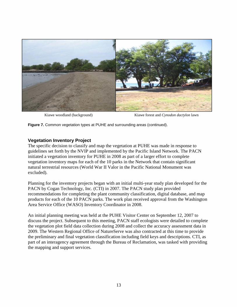
Buffelgrass stands on flats and hillslopes Dense buffelgrass in drainages Kiawe (front) and koa haole sparse shrublands (back) Lawn and tree landscape plantings on uplands Milo woodland type at Pelekane Coconut palm stands at Pelekane
Figure 7. Common vegetation types at PUHE and surrounding areas.
13
Kiawe woodland (background) Kiawe forest and Cynodon dactylon lawn Figure 7. Common vegetation types at PUHE and surrounding areas (continued). Vegetation Inventory Project The specific decision to classify and map the vegetation at PUHE was made in response to guidelines set forth by the NVIP and implemented by the Pacific Island Network. The PACN initiated a vegetation inventory for PUHE in 2008 as part of a larger effort to complete vegetation inventory maps for each of the 10 parks in the Network that contain significant natural terrestrial resources (World War II Valor in the Pacific National Monument was excluded). Planning for the inventory projects began with an initial multi-year study plan developed for the PACN by Cogan Technology, Inc. (CTI) in 2007. The PACN study plan provided recommendations for completing the plant community classification, digital database, and map products for each of the 10 PACN parks. The work plan received approval from the Washington Area Service Office (WASO) Inventory Coordinator in 2008. An initial planning meeting was held at the PUHE Visitor Center on September 12, 2007 to discuss the project. Subsequent to this meeting, PACN staff ecologists were detailed to complete the vegetation plot field data collection during 2008 and collect the accuracy assessment data in 2009. The Western Regional Office of NatureServe was also contracted at this time to provide the preliminary and final vegetation classification including field keys and descriptions. CTI, as part of an interagency agreement through the Bureau of Reclamation, was tasked with providing the mapping and support services.

14
As a team, the objectives were to produce data consistent with the national program’s mandates. These include the following: Spatial Data
• Map classification based on PUHE-specific requirements; • Map classification description and key; • Spatial database of vegetation communities; • Digital and hardcopy maps of vegetation communities; • Metadata for spatial databases; • Complete accuracy assessment of spatial data.
Vegetation Information
• rUSNVC-based vegetation data; • Dichotomous field key of vegetation associations; • Formal description for each vegetation association; • Ground photos of vegetation associations; • Field data in database format.
Scope of Work Vegetation mapping for PUHE occurred within an approximate 196 ha (485 ac) project boundary, encompassing the boundary of PUHE (as provided by PACN), Samuel M. Spencer County Park, and a general 0.5 km (0.31 mi) environ radius (Figure 8). The final project area determination was based on management needs, financial constraints, and time limitations. The nominal 0.5 km environs were used in this project to insure completeness and to capture some minimal data for various management considerations outside of PUHE (such as non-native plant vectors). Also the size of the environs corresponded to the size proposed in the work plan and matches the other vegetation mapping protocols in the PACN.

15
Figure 8. The vegetation mapping project boundary and PUHE park boundary.


17
Methods The vegetation mapping project at PUHE was considered to be in the “small park” category based on the overall size of the project area (TNC and ESRI 1994b). As such, the standard methodology for sampling and mapping is to visit the entire park and select representative sites. These sites are used to characterize the vegetation types and explain their distribution across the park without having to survey each stand of vegetation. Based on this approach the assignment of responsibilities was divided into five major steps following the 12 Step Guidance for NPS Vegetation Inventories (NPS 2009).
1. Plan, gather data, and coordinate tasks; 2. Survey PUHE to understand and sample the vegetation; 3. Classify the vegetation using the field data to rUSNVC standard associations and
alliances and crosswalk these to recognizable map units; 4. Acquire current digital imagery and interpret the vegetation from these using the
classification scheme and a map unit crosswalk; 5. Assess the accuracy of the final map product.
All protocols for this project as outlined in the following sections can be found in the original program documents produced by The Nature Conservancy and Environmental Research Systems Institute (1994a, 1994b, and 1994c) and later revisions (Lea and Curtis 2010) and can be found at this website: http://biology.usgs.gov/npsveg. Planning, Data Gathering and Coordination A series of planning conference calls were held throughout 2008 and attended by representative CTI, PACN and PUHE staff. The goals of these calls were to (1) discuss the project, (2) learn about the management issues and concerns, (3) discuss availability of existing data, (4) develop a schedule, (5) discuss procedural issues and data, (6) define potential cooperators, and (7) define a project scope. Once the boundary was finalized copies of 2006 Quickbird Imagery were obtained from the PACN. This imagery was obtained as pan-sharpened, cloud-free, 4-band, 0.6-meter resolution digital ortho-photos that covered the entire island of Hawai‘i. The specific imagery tiles covering the PUHE project area were selected, clipped and mosaiced to provide the basemap for mapping purposes. In addition to the Quickbird imagery, 1-meter, 3-band (true color) 2002 Ikonos imagery was also obtained for PUHE, but due to cloud cover and ensuing changes at PUHE since 2002 this product was only used in an ancillary role.

18
The remaining work responsibilities were assigned to the following participants: NPS-PACN • Provide oversight and project funding; • Provide the PUHE plant list; • Supply digital boundary files and ancillary data files; • Assist with fieldwork and logistical considerations; • Work with NatureServe to develop the vegetation classification; • Provide project management; • Coordinate the field work with PUHE; • Collect representative plot data; • Collect less detailed observations about the draft vegetation map; • Collect accuracy assessment data; • Provide a section for the final report describing the field portion of this project; • Compile, review, and update drafts of the vegetation map, classification and report; • Accept the final products and finalize the project.
NatureServe (Western Regional Office) • Work with NPS to develop a vegetation classification for the study area based on the
rUSNVC using quantitative analysis and ecological interpretation of the field data; • Provide guidance regarding the crosswalk of vegetation types to map units; • Write descriptions of the vegetation types found at PUHE; • Write a field key to the vegetation types found at PUHE; • Write vegetation sections (classification methods, results and discussion) of final report • Revise field methods document and review other deliverables including database and final
report. Cogan Technology, Inc. • Help with overall project facilitation and coordination; • Verify vegetation and land use/land cover signatures on the imagery; • Develop map units linked to the rUSNVC; • Provide field maps and GIS support to the field crews; • Interpret and delineate the final vegetation and land use types; • Transfer and automate interpreted data to a digital spatial database; • Produce spatial layers of plot and accuracy assessment site locations; • Assist with the accuracy assessment by picking the stratified random target points, creating
field maps and providing GIS support; • Provide a visual guide to the photo signatures of each map unit; • Provide a final report describing the project; • Document FGDC-compliant metadata for all vegetation data; • Create a DVD with reports, metadata, guides, vegetation classification, plot data, spatial data,
vegetation database (map), graphics, and ground photos.

19
Field Surveys The field methods used for developing the classification and conducting the accuracy assessment at PUHE followed the methodology outlined by the NVIP (TNC and ESRI 1994b) for small sized parks. Field crews were led by PACN ecologists with plant community sampling experience in the Hawaiian Islands and other landscapes. The list of ecological systems, vegetation alliances, and component plant associations prepared by NatureServe ecologists provided a starting point for naming the plant communities sampled in the field. The sampling goal was to collect between three and five classification plots in every plant association within the PUHE project area. However, some common associations were sampled more often and some rare types were sampled less often. An effort was made to achieve a good spatial distribution of plots across the landscape and to capture the full range of variation of each association. When a representative stand of vegetation was located a relevé macroplot was established to record stand characteristics (Figure 9); transitional areas such as ecotones were usually avoided unless they exceeded the project minimum mapping unit (MMU) of 0.5 ha (1.2 ac). Highly disturbed areas were also avoided unless they supported a distinct plant community. Classification plots were generally located in stands exceeding the MMU; however a few plots were sampled in smaller patches if the vegetation was rare and distinctive (such as coastal strand sites). Plot size and shape requirements were consistent with NVIP guidelines (TNC and ESRI 1994b). Measuring tapes were used to establish 11.28 m radius circular sampling plots for all five physiognomies sampled at PUHE (Table 2).
Figure 9. Field plot data collection at PUHE led by PACN.

20
Table 2. Plot Sizes Used for Classification Sampling at PUHE.
Dominant physiognomy Plot size Plot area Forest: trees have their crowns overlapping, usually forming 60-100% cover, and Woodland: open stands of trees with crowns usually not touching. Canopy tree cover 25-60%, OR exceeds shrub, dwarf-shrub, herb, and nonvascular cover.
Circular 11.28 m radius
400 m2
Shrubland: shrubs greater than 0.5 m tall are dominant, usually forming more than 25% cover OR exceeding tree, dwarf-shrub, herb, and nonvascular cover, and Dwarf-shrubland (e.g., heath): Shrubs less than 0.5 m tall are dominant, usually forming more than 25% cover OR exceeds tree, shrub, herb, and nonvascular cover.
Circular 11.28 m radius
400 m2
Herbaceous (e.g., grassland, meadow, marsh): Herbs dominant, usually forming more than 25% cover OR exceeds tree, shrub, dwarf-shrub, and nonvascular cover.
Circular 11.28 m radius
400 m2
Nonvascular (e.g., fen, bog, cliff): nonvascular cover dominant, usually forming more than 25% cover.
Circular 11.28 m radius
400 m2
Sparse vegetation (e.g., blowout, beach): less than 10% total vegetation cover.
Circular 11.28 m radius
400 m2
Following the establishment of each plot, environmental data were recorded on the plot field forms (Appendix A). Environmental data included: elevation, slope, aspect, landform, topographic position, soil texture and drainage, hydrologic (flooding) regime, and evidence of disturbance or wildlife use. The unvegetated surface was estimated and recorded as percent cover of: bedrock, litter and duff, wood, bare soil, large rocks (>10 cm), small rocks (0.2 to10 cm), sand (0.1 to 2 mm), lichens, and mosses. Next the vegetation was visually divided into strata, with the height and canopy cover of the dominant vegetation estimated for each stratum. Within each stratum, all taxa within the plot area were identified and the foliar cover of each taxon was estimated using cover classes (Table 3). Table 3. Cover classes and vegetation strata.
Cover scales Vegetation strata T 0–1% T1 Emergent Canopy: P >1–5% T2 Main Canopy 1 >5–15% T3 Subcanopy 2 >15–25% S1 Tall Shrubs 3 >25–35% S2 Short Shrubs 4 >35–45% S3 Dwarf-shrubs 5 >45–55% H1 Herbaceous (Graminoids) 6 >55–65% H2 Herbaceous (Forbs) 7 >65–75% H3 Herbaceous (Ferns) 8 >75–85% H4 Herbaceous (Tree seedlings) 9 >85–95% A1 Floating-leaved aquatics 10 >95% A2 Submerged-leaved aquatics
Additional species within the vegetation unit that occurred outside of sampled plots were listed separately to assist with creation of local descriptions (Appendix E). Species that were not identifiable in the field were collected for later identification and specimens were typically

21
destroyed in analysis. Species were recorded by scientific epithet familiar to researchers and a provisional vegetation type was assigned to the plot. Appendix B contains all species found within sample plots and common names used throughout the document. Field crews documented the vegetation plots as follows: (1) a species list was developed and recorded; (2) UTM NAD83 X-Y, field note headers (Identifiers/Locators), environmental descriptions, and elevation were recorded both manually on the plot forms and stored as waypoints in the GPS receiver; and (3) eight representative digital photographs were acquired for each plot. Four photos were captured facing each of the cardinal directions (N, E, S, and W), one photo was used to capture the center of the plot, and a total of three photos were used to capture the complete pages of the field forms.
In addition to the vegetation classification plots, PACN field crews collected vegetation and environmental data at several observation points. Data recorded at observation points reflected the vegetation of an area of variable spatial extent around the point rather than a measured plot, and were less detailed (Appendix A). Overall conditions at each observation point were documented by one or more digital photographs. These data were intended primarily to support modeling and interpretation of the base imagery, but were also used to help describe plant associations when local descriptions were prepared. Specifically, observation point data were collected when:
• The vegetation was homogenous, representative, and several classification plots had been sampled;
• Sampling the environs outside the PUHE boundary; • The vegetation was highly disturbed, ecotonal, or otherwise anomalous and therefore
unlikely to be classified under the rUSNVC; • CTI requested documentation of a specific photo-signature or area; • To document special features as requested by PUHE staff including seeps, invasive plant
stands; • To document a vegetation type that consistently occurred in stands smaller than the 0.5
ha (1.2 ac) MMU; • The sample point could not be safely accessed to complete the full plot.
The classification data were collected between July and October 2008. Vegetation sampling included 15 classification plots and 13 observation points (Figure 10). Vegetation Classification The first step in classifying the vegetation at PUHE was to prepare a preliminary classification prior to vegetation sampling. NatureServe provided PACN staff an USNVCv1 tabular report of all vegetation associations and alliances attributed to Hawai‘i. This list covered a much broader area than the PUHE project area and included many types that occur in the park, as well as associations that may occur in other parks in the PACN. In addition, NatureServe provided descriptions of wetland and riparian Terrestrial Ecological Systems. Ecological Systems approximate the scale of NVCSv2 Groups and were available in 2008 when this project started.

22
Figure 10. Location of vegetation plots and observation points collected at PUHE.

23
Upon completion of the plot data collection, all data were transferred by PACN staff to a Microsoft Access database. For ease of use the MS Access database mirrored the standard field form with fields and tables that matched all of the data recorded on the field forms. Following data entry, quality assurance checking was performed to minimize errors associated with duplicate entries or erroneously selected plant or association names or typos.
Unknown species identification, especially those with high cover were resolved, as were other taxonomic issues such as accepted nomenclature. Plot locations were verified by field crew members by overlaying coordinate data on the Quickbird imagery. At the completion of the field work the final database was used by NatureServe for quantitative analysis.
NatureServe began the formal classification work by combining the PUHE plot and observation data contained within the database with the similar data obtained at KAHO and PUHO (137 plots total). The first review indicated 49 field observation points did not have enough detail to fit analyses protocol and were removed from the dataset prior to multivariate analyses. However, all field observations were used during qualitative analysis and final classification. Next, the database was converted to meet NatureServe standards and all of the plant taxonomy was standardized to the USDA Plants database. After standardizing the database, NatureServe found some additional inconsistencies when the field crews assigned taxa to strata. To correct these issues, NatureServe ecologists equalized the strata so that all shrub and herbaceous vegetation (included tree seedlings) were in the proper strata and then merged individual taxa into one of four strata (Table 4). For example, noni (Morinda citrifolia) was listed in as many as six strata, but was combined into three strata (tree, shrub, and herbaceous vegetation) for classification purposes. Merging individual taxa within a plot meant combing the cover values of two records using the following formula: A + (B*(1-A)). Where A is the cover of the taxon in one occurrence and B is the cover of the taxon in the other occurrence. This formula takes into account the fact that individual plants within the strata being combined will likely shade each other so a simple addition of the cover values is rarely accurate, particularly when the cover values are moderate to high. The final dataset used in multivariate analysis for the classification had 85 unique taxa that occurred across 88 plots yielding 713 taxa records (combinations of taxa and strata). Table 4. Conversion of strata from original data to final stratum used in analyses.
Original Stratum Description Final Stratum Code T1 Emergent Tree T T2 Canopy Tree T T3 Subcanopy Tree T S1 Tall Shrub Shrub S S2 Short Shrub Shrub S S3 Dwarf Shrub Shrub S H Herbaceous Herbaceous H
H1 Graminoids Herbaceous H H2 Forbs Herbaceous H H3 Ferns and Allies Herbaceous H H4 Tree Seedlings Herbaceous H N Nonvascular Nonvascular N

24
Plant nomenclature in the NVCS is that of the Integrated Taxonomic Information System (ITIS) as reflected by the PLANTS Database (USDA -NRCS 2007). For this study, some NVCS names were modified based on Wagner and Herbst (2003) and Wagner et al. (1999) and these changes are identified throughout the document. Naming the plant associations used indicator (dominant or diagnostic) species for each of the vegetative strata present. The indicator species of the upper strata was listed first, followed by successively lower strata (e.g., canopy, subcanopy, tall shrub, short shrub, herbaceous vegetation, etc.). Plant species that may only be occasionally present in the same stratum are separated by parentheses ( ). Species that always occurred in the same stratum (or were the same lifeform) are separated by a hyphen (-). Indicator species that occurred in different strata (or are a different lifeform) were separated by a slash (/). Alliance names were concluded with the word “Alliance” to differentiate them from association names. Plant association names incorporated the physiognomic class in which the association was classified (e.g., Forest, Woodland, or Herbaceous) (FGDC 1997, 2008).
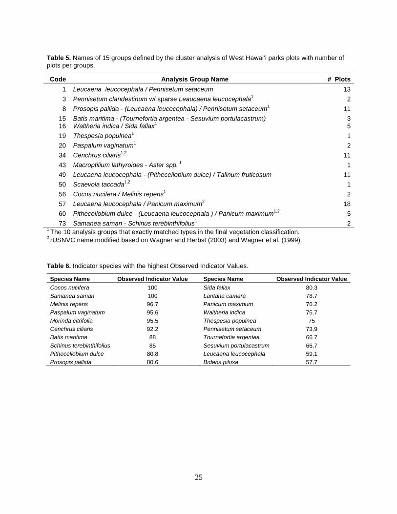
Data Analysis The data from PUHE, PUHO and KAHO were combined for analysis because of significant overlap in species composition and vegetation structure between these parks which are all located along the western coast of the island of Hawai‘i. It was expected that the parks would have similar and overlapping vegetation biodiversity. A combined analysis allowed NatureServe to compare and contrast parks, and solved the statistical problem of analyzing small data sets, which tend to have high variance. NatureServe exported the combined data into PC-Ord version 5 (McCune and Mefford 1999) and used an analytical, iterative classification process beginning with all plots and systematically removed groups of plots that were clearly different at each stage. Quantitative analytical methods have different strengths and weaknesses so results from several techniques were used and compared. The primary quantitative analytical methods included both ordination, specifically Nonmetric Multidimensional Scaling (NMS) and Detrended Correspondence Analysis (DCA) and clustering techniques (Flexible Beta linkage method). Once the qualitative analyses were completed the classification process was finalized by expertly reviewing the plant assemblages using qualitative methods and matching them to any existing known plant associations. Initial results of the analyses found 15 groups defined by the cluster analysis (Table 5) and were graphed using the two ordination methods to compare results (Figures 11 and 12). The final classification of the 88 plots in the dataset resulted in 20 types. Ten of the 15 analysis groups exactly matched types in the final classification (all plots in the group were classified the same type). Two analysis groups matched all but one plot. The three remaining analysis groups had to be interpreted plot by plot, using qualitative assessments based on the presence of indicator species or cover break thresholds by canopy characteristics e.g., shrublands versus grasslands with scattered shrubs. One of these groups, kikuyu grass (Pennisetum clandestinum) w/ sparse koa haole (Leucaena leucocephala), was erroneously generated due to a data entry error. Kikuyu grass does not occur in PUHO or KAHO and only occurs in PUHE as a lawn grass. Once this entry error was discovered this group was lumped with koa haole / fountain grass. Naturserve also ran an indicator species analysis on the 15 groups defined by the preliminary qualitative classification to generate a list of species that were important in defining the various groups (Table 6).
25
Table 5. Names of 15 groups defined by the cluster analysis of West Hawai‘i parks plots with number of plots per groups.
Code Analysis Group Name # Plots 1 Leucaena leucocephala / Pennisetum setaceum 13 3 Pennisetum clandestinum w/ sparse Leaucaena leucocephala1 2 8 Prosopis pallida - (Leucaena leucocephala) / Pennisetum setaceum1 11
15 Batis maritima - (Tournefortia argentea - Sesuvium portulacastrum) 3 16 Waltheria indica / Sida fallax1 5 19 Thespesia populnea1 1 20 Paspalum vaginatum1 2 34 Cenchrus ciliaris1,2 11 43 Macroptilium lathyroides - Aster spp. 1 1 49 Leucaena leucocephala - (Pithecellobium dulce) / Talinum fruticosum 11 50 Scaevola taccada1,2 1 56 Cocos nucifera / Melinis repens1 2 57 Leucaena leucocephala / Panicum maximum2 18 60 Pithecellobium dulce - (Leucaena leucocephala ) / Panicum maximum1,2 5 73 Samanea saman - Schinus terebinthifolius1 2
1 The 10 analysis groups that exactly matched types in the final vegetation classification. 2 rUSNVC name modified based on Wagner and Herbst (2003) and Wagner et al. (1999). Table 6. Indicator species with the highest Observed Indicator Values.
Species Name Observed Indicator Value Species Name Observed Indicator Value Cocos nucifera 100 Sida fallax 80.3 Samanea saman 100 Lantana camara 78.7 Melinis repens 96.7 Panicum maximum 76.2 Paspalum vaginatum 95.6 Waltheria indica 75.7 Morinda citrifolia 95.5 Thespesia populnea 75 Cenchrus ciliaris 92.2 Pennisetum setaceum 73.9 Batis maritima 88 Tournefortia argentea 66.7 Schinus terebinthifolius 85 Sesuvium portulacastrum 66.7 Pithecellobium dulce 80.8 Leucaena leucocephala 59.1 Prosopis pallida 80.6 Bidens pilosa 57.7

26
Figure 11. Distribution of 15 cluster analysis plot groups defined from West Hawai‘i parks using Nonmetric Multidimensional Scaling (NMS) ordination.
Figure 12. Distribution of 15 cluster analysis plot groups defined from West Hawai‘i parks using Detrended Correspondence Analysis (DCA) ordination.

27
To supplement the initial classification results and to finalize the vegetation classification, NatureServe ecologists also used ordination to examine a portion of the draft classification and displayed the types over the ordination results (quantitative analysis) using DCA and NMS methods. The results indicated that the draft classification was split too finely (30 types) and resulted in overlap of some of the types due to floristic similarities between plots. After much review and examination of the results NatureServe decided to lump types based on the ordinations and qualitative analysis resulting in 20 plant associations. Six additional types were added to this list based on qualitative review of the remaining 49 plots, yielding a total of 26 plant associations. Digital Imagery and Mapping Since PUHE represented a fairly small and accessible site, no new imagery or aerial photography was deemed necessary for this project. Instead, existing sources of imagery were evaluated and two products were selected to be used as base maps. These included the 2006 Quickbird and 2002 Ikonos products (Figure 13). The 2006 product was deemed superior by CTI technicians since it had better resolution, contained the color infrared (CIR) band, and reflected most of the recent landscape changes at PUHE (road/trail removals and the new visitor center). The 2002 product had 1-meter resolution and was provided in true-color format (3-bands). After obtaining both sets, the 2006 imagery was color balanced in Imagine Software to remove some of the edge-matching issues and sharpen the image. The 2002 imagery was also color balanced, but edge-matching was not preformed. The resulting image from the 2006 imagery was pieced together as a mosaic and clipped to just beyond the extent of the project boundary. Interpretation of the vegetation at PUHE involved a three step process: (1) image segmentation, (2) cleaning and smoothing, and (3) ground-truthing of the data. First, the 2006 imagery was re-sampled to a 3-meter pixel resolution to reduce noise and to generalize the vegetation signatures. Next, this imagery was segmented to delineate obvious landforms (e.g. open water and fields) and physiognomic features (e.g. grasslands versus woodlands). The initial segments were created using a series of trial and error multi-resolution segmentation routines in the software. The settings for scale and shape were manipulated until a desired network of images resulted. The objective of the segmentation was to create a system of lines with as coarse a scale as possible without omitting most of the small, important and obvious land cover patches. By incrementally increasing segmentation size within the program, small image objects (i.e., preliminary polygons) were continuously merged into larger ones. Completion of the segmentation was based on visual judgment of the CTI analyst when obvious, distinct features were lost. At this point in the process, the previous segmentation was adopted as the final treatment.

28
Figure 13. Examples of the Ikonos 2002 and Quickbird 2006 imagery for PUHE.
2002 Ikonos Example
2006 CIR Quickbird Example
2006 True Color Quickbird Example

29
Following segmentation, the lines were exported as ArcInfo shapefiles and converted to ArcInfo coverages. The resulting coverages were run through a series of smoothing routines provided in the ArcGIS software. Smoothing was conducted to reduce the stair-stepping pattern of the lines resulting from the large pixels. Smoothing ended when no obvious artificial or relict breaks in the lines were visible. Following smoothing, the line-work was manually cleaned to remove extraneous lines, small polygons, and polygons that obviously split a homogenous stand of vegetation. The cleaning stage was considered complete when all resulting polygons matched homogenous stands of vegetation apparent on the 2006 imagery. The lines resulting from the 2006 imagery segmentation were visually inspected in ArcInfo. Any obvious problems in the mapping (such as shifting and sliver polygons) were edited and resolved. Review of the merged polygon layer revealed that the roads and the facilities were not adequately separated from the surrounding vegetation. To resolve this, all developed areas, roads, streams and other linear or rectangular features were manually digitized directly off the 2006 imagery and incorporated into the final segmentation. After merging the digitized lines with the segmented linework the resulting preliminary GIS layer was considered complete and ready to be ground-truthed in the field. Ground-truthing the preliminary vegetation layer for PUHE involved printing 1:6,000-scale hardcopy maps. These contained the 2006 basemaps and the linework as an overlay. During three days in 2009, researchers from CTI visited representative polygons at PUHE, PUHO and KAHO. Ground-truthing consisted of verifying the maps against the actual vegetation on the ground to ensure that the polygons were labeled properly and to locate any extra or missing vegetation polygons. More general observations were also taken during this trip to help write map unit descriptions and ultimately create the mapping scheme. All the information from this trip was subsequently added to the final GIS layer to correct any errors. Upon return from the field, CTI researchers used the final classification supplied by NatureServe to create the mapping scheme. In most cases, the map units were derived on a one association or alliance to one map unit basis. Due to the limitations of the imagery, some of the associations could not be recognized consistently. This issue was addressed by either scaling up the rUSNVCS to the alliance level or combining similar associations/alliances into complexes. All of the resulting map units were then correlated or crosswalked by noting when plant associations were used as a map unit or when they were grouped. To round-out the mapping scheme, map units were created for land use types based on a mapping system developed by Anderson et al. (1976). This included unvegetated lands not in the rUSNVC, such as roads, facilities, and bare lava. A separate class of map modifiers or “Park Specials” was defined especially for PUHE to cover types that occurred either outside of the park boundary or were too small to sample. These included the coastal strand and a few other map units. All of the resulting map unit names, map unit codes, rUSNVC information, and other relevant attributes were added to each polygon in the GIS layer (Table 7).

30
Accuracy Assessment Once the vegetation layer was completed and finalized the accuracy assessment (AA) was conducted. Typically, in mapping exercises both thematic or attribute map accuracy as well as the positional or polygon line accuracy are considered. In the case of the NVIP however, the positional accuracy is usually omitted since rarely does vegetation split on discrete edges that can be positively located in the field. The subjectivity involved in this effort plus the high resolution and accuracy of Quickbird imagery allows for the assumption that all products derived from them are well within National Map Accuracy Standards for 1:12,000-scale maps (±30 feet). Table 7. Polygon attribute items and descriptions used in the PUHE GIS coverage.
ATTRIBUTE DESCRIPTION OBJECTID* Unique code for each polygon AREA* Surface area of the polygon in meters squared PERIMETER* Perimeter of the polygon in meters VEG_CODE Final Map Unit Codes – Project specific MAP_DESC Map Unit Common Description Name – Project specific DENS_MOD Modifier - Percent cover of the upper stratum layer in the polygon Percent cover classes: Sparse 10 - 25%, Open 25 - 60%, Discontinuous - Closed > 60% PTRN_MOD Modifier - Vegetation pattern within the polygon Vegetation pattern classes: Evenly Dispersed = Homogeneous Grouped Stands of Vegetation = Bunched / Clumped, String of Vegetation = Linear HT_MOD Modifier - Height range of the dominant vegetation layer Height classes: < 1, 1-5, 5-15, 15-30 & >30 meters NVC_ELCODE Corresponding Association Code – NVCS derived (NatureServe) Association = Community Element Global Code – Elcode link to the NVCS ASSN_NAME Project Community Name - NVCS Association(s) ASSN_CNAME Project Common Community Name - synonym name of Association(s) ALL_CODE Alliance Name Code – NVCS derived (NatureServe) Alliance = Alliance Global Code – Alliance Link to the NVCS ALL_NAME Project Alliance Name = NVCS Alliance(s) ALL_CNAME Project Common Alliance Name = NVCS Alliance(s) GROUP NVCS Group= Group name MACROGROUP NVCS Macrogroup = Macrogroup name DIVISION NVCS Division = Division name FORMATION NVCS Formation = Formation name SUBCLASS NVCS Subclass = Subclass name CLASS NVCS Class = Class name LUC_II_GEN General Land Use and Land Cover Classification System Name Project specific based on Level I or II of Anderson et al. (1976) LUC_II Specific Land Use and Land Cover Classification System Name Project specific Level II or Level III of Anderson et al. (1976) COMMENTS Additional Comments about the Vegetation in Individual Polygons ACRES Surface area of the polygon in acres (*ArcInfo© default items)

31
The thematic accuracy of the vegetation map was assessed using the methodology following the standards provided by the NVIP (TNC and ESRI 1994c). This protocol has since been revised by the NVIP (Lea and Curtis 2010) but this project was started before the new standards were in place. The previous protocols included a four step AA process consisting of a sample design, sample site selection, data collection, and data analysis. The design of the AA process followed the five possible scenarios provided in the field manual with stratified random targets placed in each map class based on their respective frequency and abundance (Table 8). Table 8. NVIP Sampling protocol for AA points.
Scenario Description # Polygons Area (ac)
Recommended # of Samples
A The class is abundant. It covers more than 50 hectares of the total area and consists of at least 30 polygons. In this case, the recommended sample size is 30.
> 30 > 125 30
B
The class is relatively abundant. It covers more than 50 hectares of the total area but consists of fewer than 30 polygons. In this case, the recommended sample size is 20. The rationale for reducing the sample size for this type of class is that sample sites are more difficult to find because of the lower frequency of the class.
< 30 > 125 20
C
The class is relatively rare. It covers less than 50 hectares of the total area but consists of more than 30 polygons. In this case, the recommended sample size is 20. The rationale for reducing the sample size is that the class occupies a small area. At the same time, however, the class consists of a considerable number of distinct polygons that are possibly widely distributed. The number of samples therefore remains relatively high because of the high frequency of the class.
> 30 < 125 20
D
The class is rare. It has more than 5 but fewer than 30 polygons and covers less than 50 hectares of the area. In this case, the recommended number of samples is 5. The rationale for reducing the sample size is that the class consists of small polygons and the frequency of the polygons is low. Specifying more than 5 sample sites will therefore probably result in multiple sample sites within the same (small) polygon. Collecting 5 sample sites will allow an accuracy estimate to be computed, although it will not be very precise.
5-30 < 125 5
E
The class is very rare. It has fewer than 5 polygons and occupies less than 50 hectares of the total area. In this case, it is recommended that the existence of the class be confirmed by a visit to each sample site. The rationale for the recommendation is that with fewer than 5 sample sites (assuming 1 site per polygon) no estimate of level of confidence can be established for the sample (the existence of the class can only be confirmed through field checking).
< 5 < 125 Visit all and confirm

32
These parameters were loaded into a custom GIS program along with the vegetation layer. This program picked the random target locations and also buffered them 10 meters (33 ft) away from any polygon boundary and 50 m (165 ft) away from any other point. Being able to choose minimum distance to polygon boundaries helped to minimize confusion and accounted for the horizontal error typically encountered in common GPS receivers (±5 m). To complete the sampling targets, additional points were added to long linear polygons and rare types. The resulting target locations were restricted to those within the boundaries of PUHE. Once the target locations were selected, PACN botanists were provided with draft field maps, overview maps, map unit definitions, the key to the associations (Appendix D), and digital GPS files containing the location of the target AA sites. Between January and March 2010, the botanists traveled to the AA target sites and determined the vegetation association using the field key (Figure 14). At each target they recorded the primary and secondary associations that occurred within the mapped polygon up to roughly 50 m (165 ft) radius. They also recorded height and cover of vegetative strata, environmental data, and percent canopy cover of the major species (see AA point form in Appendix A). Other nearby vegetation types and any recent disturbance were also recorded. To better assist the analysis a minimum of four photographs were taken at each AA point in the sequence of cardinal directions, N-E-S-W. If the point was too close to dense, especially shrubby vegetation, one or more optional photographs were taken at a distance to show the character of the vegetation.
Figure 14. Accuracy assessment field data collection at PUHE.

33
During 2010, a total of 57 points were sampled (Figure 15). The data recorded on the field forms were subsequently entered into a Microsoft Access database and reviewed for data entry errors by NPS staff. Incomplete data on the field sheets were corrected if possible. The results were imported from the database into a GIS layer where they were visually compared in two stages to the vegetation map coverage. The first step was to compare the AA points to the original target locations to check for errors and correct if possible. General errors in the data included incorrect UTM coordinates (standing outside of the target polygon), incorrect field call (based on actual species cover values) or incomplete polygons (i.e. unclosed polygons). Changes were made and recorded in the comments field of the AA point layer. The most common GPS receiver error included transposing two UTM coordinate numbers. The second review step involved deciding between the primary, secondary or tertiary field call for the plant association as recorded by the field crew. To accomplish this, CTI had to assign a final map unit for every point by choosing between the different calls. This was done by first adding a new attribute to the AA point layer and then comparing the assigned field names of the point with its corresponding location on the digital imagery. In most cases, the primary vegetation map unit name assigned by the field crew was used. However, some points were assigned their secondary field call based on one of the following reasons: (1) it appeared that the second call was the better choice due to the overhead perspective (e.g. a stand judged to be sparse woodland on the imagery vs. called herbaceous vegetation in the field), (2) the data were actually recorded in a stand that was too small (i.e. inclusion below MMU size), or (3) the second call more appropriately matched the ecological context (e.g. coastal strand vegetation along the coast vs. upland vegetation). Once the data were reviewed, the accuracy analysis was conducted. This was accomplished by using CTI custom GIS programs and AA templates supplied by the NVIP. Through this automated process, the final map units in the AA layer were compared to the map unit designations for their corresponding polygons. All of the statistics and calculations used to analyze these data are described at length in the program manuals (TNC and ESRI 1994c and Lea and Curtis 2010). Final assessments for each point were recorded using error matrices.

34
Figure 15. Location of accuracy assessment points collected at PUHE.

35
Results Vegetation Classification This combined classification for the West Hawai‘i parks (PUHE, PUHO and KAHO) totaled 25 vegetation types including nine woodlands, eight shrublands, six herbaceous vegetation types, and two sparsely vegetated types (Table 9). This vegetation classification work produced a total of 18 rUSNVC Associations representing 11 Alliances and six Groups. Seven Park Special vegetation types were created that represent local vegetation stands that differ significantly from existing rUSNVC association concepts, but lack enough data to develop into a new association. Park Special types are not officially included in the rUSNVC Hierarchy, but many times can be linked to the Group level for classification and mapping purposes. Some of these Park Special communities may become new associations with additional data or they may be subsumed into existing rUSNVC associations.
There was some overlap between the three parks with five types sampled in more than one park and three types sampled in all three parks. Some types such as the two sparse vegetation types were mapped in all parks although only sampled at KAHO. The majority of these vegetation types are dominated by non-native species (19 of 25) and considered semi-natural or ruderal.
The vegetation classification work at PUHE resulted in five vegetation types. When summarized by class, PUHE contained three woodlands and two herbaceous vegetation types. There were a total of four rUSNVC Associations and one Park Special, representing four Alliances and four Groups. Table 10a lists the final PUHE classification up to the group level of the rUSNVC. Lists of plots and local descriptions are available in Appendix C and Appendix E, respectively. The PUHE vegetation classification is based on plot data sampled by field crews. However, there are nine additional vegetation types in the map legend that are not in the PUHE vegetation classification (Table 10b). These include: Monkeypod (Samanea saman) - Christmas berry (Schinus terebinthifolius) Semi-natural Woodland, Koa Haole Lowland Dry Semi-natural Shrubland, Bougainvillea (Bougainvillea glabra) Semi-natural / Planted Shrubland, A‘a Lava with Sparse Vegetation, Coastal Strand Sparse Vegetation, Pahoehoe Lava Sparse Vegetation, Mixed Semi-natural / Ornamental Tree Woodland, Pili (Heteropogon contortus) Planted Herbaceous Vegetation, and Planted Grasses. Four of these additional types are Park Specials, four are unclassified map units and only one, Koa Haole Lowland Dry Semi-natural Shrubland, is a rUSNVC association. All are dominated by non-native species. Vegetation types in the PUHE classification and the additional types are included in the dichotomous field key (Appendix D), but local descriptions were not written for the additional types because plot data were not collected for these types at PUHE.

36
Table 9. Summary Plant Associations and Park Specials for West Hawai‘i parks with number of plots sampled.
Plant Communities of West Hawai‘i Parks PUHE KAHO PUHO Total A‘a Lava with Sparse Vegetation [Park Special] 2
2
Batis maritima Semi-natural Dwarf-shrubland 6
6 Bougainvillea glabra Semi-natural / Planted Shrubland [Park Special] 1
1
Cenchrus ciliaris Semi-natural Herbaceous Vegetation2 12
12 Coastal Strand Sparse Vegetation [Park Special]1 1
1
Cocos nucifera Strand Woodland1 1 1 6 8 Fimbristylis spp. Coastal Dry Herbaceous Vegetation1 1 1 Leucaena leucocephala - Pithecellobium dulce Semi-natural Shrubland [Park Special] 2 2 Leucaena leucocephala / Pennisetum setaceum Semi-natural Shrubland 8
8
Leucaena leucocephala / Panicum maximum Semi-natural Shrubland2 12 12 Leucaena leucocephala Lowland Dry Semi-natural Shrubland 11 11 Macroptilium lathyroides Herbaceous Vegetation [Park Special] 2
2
Melinis repens Semi-Natural Herbaceous Vegetation 2 2 Paspalum vaginatum Semi-natural Herbaceous Vegetation 3
3
Panicum maximum Lowland Dry Semi-natural Herbaceous Vegetation2 5 5 Pennisetum setaceum Semi-natural Herbaceous Vegetation 8
8
Pithecellobium dulce Semi-natural Woodland 8 8 Prosopis pallida Coastal Dry Semi-natural Woodland 10 9 1 20 Samanea saman - Schinus terebinthifolius Semi-natural Woodland [Park Special] 2 2 Scaevola taccada Coastal Dry Shrubland1,2 1 1 2 Schinus terebinthifolius / Pennisetum setaceum Semi-natural Woodland 3
3
Sida cordifolia Semi-natural Herbaceous Vegetation [Park Special] 1 1 Thespesia populnea / Sparse Understory Woodland1 1 3 1 5 Tournefortia argentea Semi-natural Woodland 2
2
Waltheria indica - Sida fallax Shrubland1 6 1 7 Total number of plots 26 54 54 134
1 Native or early Polynesian introduced naturalized types. 2 rUSNVC name modified based on Wagner and Herbst (2003) and Wagner et al. (1999).

37
Table 10a. PUHE vegetation classification with rUSNVC hierarchy to Group level.
Association Name Common Name Elcode1 Alliance Name A.Key2 Group Name
Woodlands (Native and Polynesian introduced)
Cocos nucifera Strand Woodland Coconut Palm
Strand Woodland
CEGL 005402
Cocos nucifera Coastal Woodland
Alliance A.2691
Hawaiian Dry Scrub & Herb
Coastal Strand Group
Thespesia populnea / Sparse Understory Woodland
Milo / Sparse Understory Woodland
CEGL 005412
Thespesia populnea Coastal Woodland Alliance
A.2690 Hawaiian Lowland
Dry Forest & Woodland Group
Woodland (Ruderal)
Prosopis pallida Coastal Dry Semi-natural Woodland
Kiawe Coastal Dry Semi-
natural Woodland
CEGL 008118
Prosopis pallida Ruderal Woodland
Alliance A.2699 Hawaiian Ruderal
Dry Forest Group
Herbaceous Vegetation (Ruderal)
Cenchrus ciliaris Semi-natural Herbaceous Vegetation3
Buffelgrass Semi-natural Herbaceous Vegetation
CEGL 005407
(Cenchrus ciliaris - Pennisetum
setaceum) - Mixed Medium-Tall
Ruderal Grassland Alliance3
A.2693
Hawaiian Ruderal Lowland
Shrubland, Grassland &
Savanna Group
Macroptilium lathyroides Herbaceous Vegetation
Wild Bean Herbaceous Vegetation
CEPS 009517 N/A N/A
Hawaiian Ruderal Lowland
Shrubland, Grassland &
Savanna Group 1 Unique rUSNVC Association Element Code with “CEPS” indicating Park Specials. 2 Unique rUSNVC Alliance Key Code. 3 rUSNVC name modified based on Wagner and Herbst (2003) and Wagner et al. (1999).
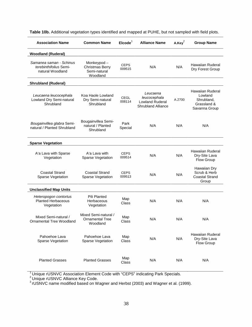
38
Table 10b. Additional vegetation types identified and mapped at PUHE, but not sampled with field plots.
Association Name Common Name Elcode1 Alliance Name A.Key2 Group Name
Woodland (Ruderal)
Samanea saman - Schinus terebinthifolius Semi-
natural Woodland
Monkeypod –
Christmas Berry Semi-natural
Woodland
CEPS 009515 N/A N/A Hawaiian Ruderal
Dry Forest Group
Shrubland (Ruderal)
Leucaena leucocephala Lowland Dry Semi-natural
Shrubland
Koa Haole Lowland Dry Semi-natural
Shrubland
CEGL 008114
Leucaena leucocephala
Lowland Ruderal Shrubland Alliance
A.2700
Hawaiian Ruderal Lowland
Shrubland, Grassland &
Savanna Group
Bougainvillea glabra Semi-natural / Planted Shrubland
Bougainvillea Semi-natural / Planted
Shrubland
Park Special N/A N/A N/A
Sparse Vegetation
A‘a Lava with Sparse Vegetation
A‘a Lava with Sparse Vegetation
CEPS 009514 N/A N/A
Hawaiian Ruderal Dry-Site Lava Flow Group
Coastal Strand Sparse Vegetation
Coastal Strand Sparse Vegetation
CEPS 009513 N/A N/A
Hawaiian Dry Scrub & Herb
Coastal Strand Group
Unclassified Map Units
Heteropogon contortus Planted Herbaceous
Vegetation
Pili Planted Herbaceous Vegetation
Map Class N/A N/A N/A
Mixed Semi-natural / Ornamental Tree Woodland
Mixed Semi-natural / Ornamental Tree
Woodland
Map Class N/A N/A N/A
Pahoehoe Lava Sparse Vegetation
Pahoehoe Lava Sparse Vegetation
Map Class N/A N/A
Hawaiian Ruderal Dry-Site Lava Flow Group
Planted Grasses Planted Grasses Map Class N/A N/A N/A
1 Unique rUSNVC Association Element Code with “CEPS” indicating Park Specials. 2 Unique rUSNVC Alliance Key Code. 3 rUSNVC name modified based on Wagner and Herbst (2003) and Wagner et al. (1999).
39
Digital Imagery and Mapping For PUHE, 31 map units (14 vegetated, five geologic, and 12 land-use/land-cover) were developed . The final list of map classes/units was directly crosswalked to corresponding plant associations and land use classes (Table 11). PUHE map classes represent a compromise between the detail of the rUSNVC, resource management needs, and the limitations of the imagery. As a result, the mapping legend does not exactly match the rUSNVC. In most cases the rUSNVC and Park Special associations were used as map units. However, in three cases additional vegetation map units (Unclassified Map Unit) were used when unique stands of vegetation were apparent on the imagery, but did not have corresponding plant associations. Appendix F contains descriptions and representative photographs of all of the vegetation map units. The following types represent the possible map scenarios for the PUHE project:
1. One-to-one relationship = When a plant association or vegetation alliance had a unique photo signature and could be readily delineated on the imagery, the map unit adopted the plant association/alliance name or similar synonym.
2. Unclassified Map Unit = When unique stands of vegetation apparent on the imagery did not have a corresponding rUSNVC plant association, Park Special, or vegetation alliance either due to their small size or location outside of PUHE.
3. Land Use – Land Cover = Non-vegetated areas and vegetation types not recognized by the NVCS received Anderson et al. (1976, updated 2002) map unit designations.
Vegetation Map The PUHE vegetation map consisted of 426 polygons totaling 183 ha (453 ac) (Appendix G); average polygon size was about 0.4 ha (1 ac) (Table 12). The small polygon size was lower than the NVIP standard of 0.5 ha (minimum mapping unit) due to the small size of the park and the importance of the rare vegetation types to the staff. The mapping was also finely detailed since the imagery was of high resolution allowing for very small stands of non-native species to be accurately delineated.
Lands managed by the NPS consisted of almost 32 ha (80 ac) representing about 18% of the total project area. The remaining mapping in the environs consisted of a mixture of private, state and county lands totaling 151 ha (373 ac). Of the total 426 polygons, 51% or 93 ha (229 ac) consisted of the non-native grassland type, Buffelgrass Semi-natural Herbaceous Vegetation. The most prevalent map class in terms of polygons (181 polygons) was the Kiawe Coastal Dry Semi-natural Woodland that represented many isolated stands.
The PUHE vegetation map should be considered a spatial database that contains many additional polygon attributes not presented in the preceding. The extensive data are difficult to convey in a table or on a two-dimensional map, but it should be understood that the different attributes can be combined at different scales and resolutions to produce additional products better representing the full spectrum of the vegetative diversity. For example, older, more mature stands of non-native vegetation can quickly be located by querying the GIS vegetation layer for non-native vegetation types along with high density (>60%) and the tallest height class (5 to15 m). Figure 16 is an example of a fine scale (1:6,000-scale) PUHE vegetation map created from the GIS spatial database with the 2006 Quickbird imagery as the background.

40
Table 11. Map classes and relationships to plant associations and other map units.
Map Code Map Class Name rUSNVC Association Assigned to Map Class (or Map Unit Description)
Relationship
W_CONU Cocos nucifera Strand Woodland Cocos nucifera Strand Woodland 1 : 1
W_ORNA Mixed Semi-natural / Ornamental Tree Woodland (No Association -Planted) Unclassified
Map Unit
W_PRPA Prosopis pallida Coastal Dry Semi-natural Woodland
Prosopis pallida Coastal Dry Semi-natural Woodland 1 : 1
W_SASA Samanea saman - Schinus terebinthifolius Semi-natural Woodland
Samanea saman - Schinus terebinthifolius Semi-natural Woodland [Park Special]
1 : 1
W_THPO Thespesia populnea / Sparse Understory Woodland
Thespesia populnea / Sparse Understory Woodland 1 : 1
S_BOGL Bougainvillea glabra Semi-natural / Planted Shrubland
Bougainvillea glabra Semi-natural / Planted Shrubland [Park Special] 1 : 1
S_LELE Leucaena leucocephala Lowland Dry Semi-natural Shrubland
Leucaena leucocephala Lowland Dry Semi-natural Shrubland 1 : 1
H_HECO Heteropogon contortus Planted Herbaceous Vegetation (No Association - Planted) Unclassified
Map Unit
H_MALA Macroptilium lathyroides Herbaceous Vegetation
Macroptilium lathyroides Herbaceous Vegetation [Park Special] 1 : 1
H_CECI Cenchrus ciliaris Semi-natural Herbaceous Vegetation
Cenchrus ciliaris Semi-natural Herbaceous Vegetation1 1 : 1
H_LAWN Planted Grasses (No Association –Planted Lawns) Unclassified Map Unit
SV_A‘A A‘a Lava with Sparse Vegetation A‘a Lava with Sparse Vegetation [Park Special] 1 : 1
SV_CS Coastal Strand Sparse Vegetation Coastal Strand Sparse Vegetation [Park Special] 1 : 1
SV_PA Pahoehoe Lava Sparse Vegetation (No Association) Unclassified Map Unit
B_BE Beaches (Barren Sand Beaches) Land Use - Cover
B_CB Coastal Basalt (Rock outcrops next to the ocean) Land Use -Cover
B_DL Developed Lava (Barren crushed or rock lava used for cultural sites, roadsides piers)
Land Use - Cover
B_ER Exposed Reef and Tidal Pools (Submerged features) Land Use - Cover
B_PA Pahoehoe Lava (Barren pahoehoe lava) Land Use - Cover
1rUSNVC name modified based on Wagner and Herbst (2003) and Wagner et al. (1999).
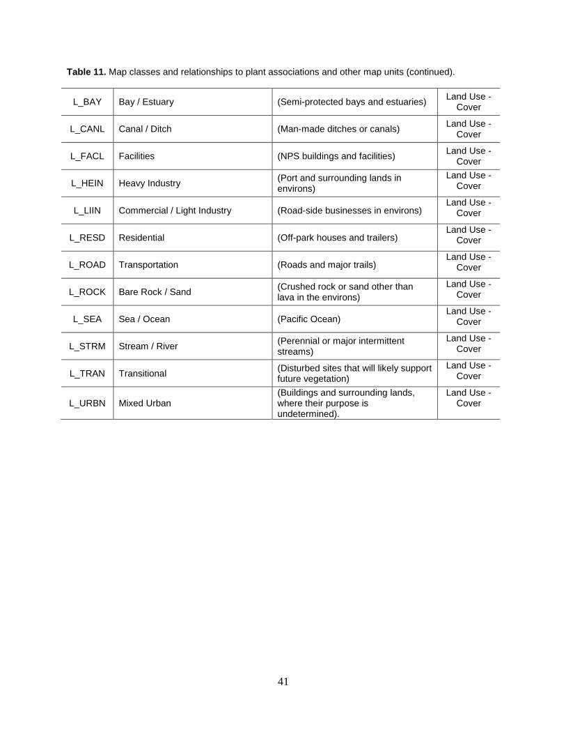
41
Table 11. Map classes and relationships to plant associations and other map units (continued).
L_BAY Bay / Estuary (Semi-protected bays and estuaries) Land Use - Cover
L_CANL Canal / Ditch (Man-made ditches or canals) Land Use - Cover
L_FACL Facilities (NPS buildings and facilities) Land Use - Cover
L_HEIN Heavy Industry (Port and surrounding lands in environs)
Land Use - Cover
L_LIIN Commercial / Light Industry (Road-side businesses in environs) Land Use -
Cover
L_RESD Residential (Off-park houses and trailers) Land Use -
Cover
L_ROAD Transportation (Roads and major trails) Land Use -
Cover
L_ROCK Bare Rock / Sand (Crushed rock or sand other than lava in the environs)
Land Use - Cover
L_SEA Sea / Ocean (Pacific Ocean) Land Use -
Cover
L_STRM Stream / River (Perennial or major intermittent streams)
Land Use - Cover
L_TRAN Transitional (Disturbed sites that will likely support future vegetation)
Land Use - Cover
L_URBN Mixed Urban (Buildings and surrounding lands, where their purpose is undetermined).
Land Use - Cover

42
Table 12. Summary statistics for the PUHE map class polygons. Map Code Map Unit Description NPS Lands Total Project Area
# of
Polygons Acres Hectares # of Polygons Acres Hectares
W_CONU Cocos nucifera Strand Woodland 4 0.2 0.1 7 1.0 0.4
W_ORNA Mixed Semi-natural / Ornamental Tree Woodland 0 0 0 5 0.1 0.0
W_PRPA Prosopis pallida Coastal Dry Semi-natural Woodland 44 14.5 5.9 181 71.0 28.7
W_SASA Samanea saman - Schinus terebinthifolius Semi-natural Woodland 0 0 0 3 0.2 0.1
W_THPO Thespesia populnea / Sparse Understory Woodland 12 1.2 0.5 21 3.3 1.3
S_BOGL Bougainvillea glabra Semi-natural / Planted Shrubland 0 0 0 1 0.1 0.0
S_LELE Leucaena leucocephala Lowland Dry Semi-natural Shrubland 2 0.5 0.2 13 6.2 2.5
H_HECO Heteropogon contortus Planted Herbaceous Vegetation 1 0.5 0.2 1 0.5 0.2
H_MALA Macroptilium lathyroides Herbaceous Vegetation 0 0 0 1 0.1 0.0
H_CECI Cenchrus ciliaris Semi-natural Herbaceous Vegetation 47 47.9 19.4 96 228.6 92.4
H_LAWN Planted Grasses 2 0.6 0.2 7 2.1 0.8
SV_A‘A A‘a Lava with Sparse Vegetation 0 0 0 2 1.7 0.7
SV_CS Coastal Strand Sparse Vegetation 0 0 0 4 0.6 0.2
SV_PA Pahoehoe Lava Sparse Vegetation 4 0.3 0.1 9 2.6 1.1
B_BE Beaches 0 0 0 2 1.0 0.4
B_CB Coastal Basalt 6 0.2 0.1 1 0.6 0.2
B_DL Developed Lava 10 2.2 0.9 19 4.2 1.7
B_ER Exposed Reef and Tidal Pools 0 0 0 3 0.4 0.2
B_PA Pahoehoe Lava 0 0 0 1 0.2 0.1
B_ROCK Bare Rock / Sand 1 <0.1 <0.1 3 12.0 4.8
L_BAY Bay / Estuary 0 0 0 1 0.8 0.3
L_CANL Canal / Ditch 0 0 0 4 1.9 0.8
L_FACL Facilities 6 0.6 0.2 11 0.7 0.3
L_HEIN Heavy Industry 0 0 0 6 18.5 7.5

43
Table 12. Summary statistics for the PUHE map class polygons (continued).
Map Code Map Unit Description NPS Lands Total Project Area
# of Polygons Acres Hectares # of Polygons Acres Hectares
L_LIIN Commercial / Light Industry 0 0 0 2 1.2 0.5
L_RESD Residential 0 0 0 2 1.1 0.4
L_ROAD Transportation 5 6.4 2.6 6 19.0 7.7
L_SEA Sea / Ocean 9 <0.1 <0.1 2 68.7 27.8
L_STRM Stream / River 1 0.2 0.1 1 0.3 0.1
L_TRAN Transitional 9 3.4 1.4 10 3.6 1.5
L_URBN Mixed Urban 0 0 0 1 0.2 0.1
Total Vegetation 116 65.7 26.6 351 318.1 128.5
Total Barren Geology 17 2.4 1.0 29 18.4 7.4
Total Land Use / Land Cover 30 10.6 4.3 46 116.0 46.9
Totals 163 78.7 31.9 426 452.5 182.8

44
Figure 16. Example of the PUHE vegetation map layer.
Map Code Map Unit Description W_CONU Cocos nucifera Strand
Woodland W_ORNA Mixed Semi-natural /
Ornamental Tree Woodland W_PRPA Prosopis pallida Coastal Dry
Semi-natural Woodland W_SASA Samanea saman - Schinus
terebinthifolius Semi-natural Woodland
W_THPO Thespesia populnea Forest S_LELE Leucaena leucocephala
Lowland Dry Semi-natural Shrubland
S_BOGL Bougainvillea glabra Semi-natural / Planted Shrubland
H_HECO Heteropogon contortus Lowland Dry Herbaceous Vegetation
H_MALA Macroptilium lathyroides Herbaceous Vegetation
H_CECI Cenchrus ciliaris Semi-natural Herbaceous Vegetation
H_LAWN Planted Grasses SV_A‘A A‘a Lava with Sparse Vegetation SV_CS Coastal Strand Sparse
Vegetation SV_PA Pahoehoe Lava Sparse
Vegetation B_BE Beaches B_CB Coastal Basalt B_DL Developed Lava B_ER Exposed Reef and Tidal Pools B_PA Pahoehoe Lava L_BAY Bay / Estuary L_CANL Canal / Ditch L_FACL Facilities L_HEIN Heavy Industry L_LIIN Commercial / Light Industry L_RESD Residential L_ROAD Transportation L_ROCK Bare Rock / Sand L_SEA Sea / Ocean L_STRM Stream / River L_TRAN Transitional L_URBN Mixed Urban

45
Accuracy Assessment The 2010 AA effort yielded 57 points distributed throughout PUHE. In addition to using the AA points in the map analysis, many of the points were also used to update the classification and to revise the field key and local descriptions. For example, after the AA data collection NatureServe added the Koa Haole Lowland Dry Semi-natural Shrubland and several other types to PUHE’s list of additional types in map legend but not in the final classification. This post-analysis of the AA data documented the presence of types that were mapped, but not sampled for classification analysis and highlighted a need for further sampling.
Analysis of the AA points involved a point-by-point review in two stages. In stage one, an AA GIS point file was created from the point coordinates recorded in the field. These sites were digitally overlaid on the vegetation map and a comparison of the final AA field call versus the vegetation polygon label was conducted by CTI staff. Stage one resulted in a preliminary error matrix that was reviewed by PACN and CTI. Adjustments were made to the field calls at this time based on the actual cover values recorded and taking into account possible correct second and third field calls. In most cases, the correct second and third calls were very closely related to the incorrect primary call. Following incorporation of changes, the raw, overall accuracy of the PUHE vegetation layer was found to be 88%. Results were presented to PACN staff and recommendations were made to improve the accuracy of the map. These included:
• Agreement with all location and type code adjustments made by CTI; • Pahoehoe Sparse Vegetation map class was retained assuming that most polygons of this
type contained sparse buffelgrass – this change was noted in the comments field of the GIS database;
• The Coconut Palm Strand Woodland was retained with lower accuracy; • The Milo / Sparse Understory Woodland Semi-natural Woodland was retained with
lower accuracy; • The Pili Planted Herbaceous Vegetation map unit was retained as a park special.
Stage two of the analysis involved incorporating the NPS recommendations and re-running the accuracy assessment using the new NVIP protocols (Lea and Curtis 2010). Following the vegetation map update, errors were reported in both a sample contingency table (Table 13) and a population contingency table (Table 14). The sample contingency table includes the observation counts, with the predicted, sample data values (vegetation map classes) as rows and the observed reference data values (vegetation types as identified on the ground) as columns. The value in the cells is the number of accuracy assessment observations mapped in each class (row) that were found to be of a specific class (column) in the field. The values in the shaded cells along the diagonal represent counts for correctly classified observations, where the reference data (column) vegetation type matches the mapped vegetation type (row) value.
The population contingency table is similar to the sample table: however, the values in each cell are the proportion of the target area in the corresponding true and mapped vegetation classes, rather than the raw count of observations. The row sums pi+ are the proportions of the total area mapped as type i. The column sums p+J are the proportions of the total area that are truly class J, which is not known, but can be estimated from the reference data values. The final overall accuracy was assessed at 97% with a Kappa index of 82%.

46
Table 13. Sample Contingency Table for PUHE.
Table 14. Population Contingency Table for PUHE.
Observed
Map Code W_CONU W_PRPA W_THPO S_LELE H_CECI H_LAWN SV_CS SV_PA 1 2 3 4
P W_CONU 0.002 0.002 0.000 0.000 0.000 0.000 0.000 0.000 50% 0% 100% 0%
r W_PRPA 0.000 0.213 0.000 0.000 0.012 0.000 0.000 0.000 95% 84% 100% 23%
e W_THPO 0.000 0.003 0.007 0.000 0.001 0.000 0.000 0.000 63% 28% 97% 1%
d S_LELE 0.000 0.000 0.000 0.020 0.000 0.000 0.000 0.000 100% 50% 100% 2%
i H_CECI 0.000 0.000 0.000 0.000 0.725 0.000 0.000 0.000 100% 98% 100% 72%
c H_LAWN 0.000 0.000 0.000 0.000 0.000 0.007 0.000 0.000 100% 75% 100% 1%
t SV_CS 0.000 0.000 0.000 0.000 0.000 0.000 0.002 0.000 100% 50% 100% 0%
d SV_PA 0.000 0.000 0.000 0.000 0.008 0.000 0.000 0.000 0% 0% 25% 1%
A 100.0% 98.1% 100.0% 100.0% 97.1% 100.0% 100.0% 0.0%
B 99.8% 96.6% 99.7% 100.0% 95.7% 100.0% 100.0% 0.0%
C 100.0% 99.6% 100.0% 100.0% 98.6% 100.0% 100.0% 0.0%
D 0.20 27.71 0.83 2.50 95.08 0.85 0.24 0.00
ROW A = PRODUCERS' ACCURACY (Pi=Y|J=Y) ROW B = LOWER LIMIT, 90% CONFIDENCE INTERVAL, PRODUCERS' ACCURACY ROW C = UPPER LIMIT, 90% CONFIDENCE INTERVAL, PRODUCERS' ACCURACY ROW D = ESTIMATED TRUE AREA (A+J) (HECTARES) COLUMN 1 = USERS' ACCURACY (PJ=X|i=X) COLUMN 2 = LOWER LIMIT, 90% CONFIDENCE INTERVAL, USERS' ACCURACY COLUMN 3 = UPPER LIMIT, 90% CONFIDENCE INTERVAL, USERS' ACCURACY COLUMN 4 = pi+, PROPORTIONS OF TOTAL AREA MAPPED AS TYPE i OVERALL ACCURACY (Pc) = 97.4% LOWER LIMIT, 90% CONFIDENCE INTERVAL = 95.5% UPPER LIMIT, 90% CONFIDENCE INTERVAL = 99.4% KAPPA (Κ): = 82.1% LOWER LIMIT, 90% CONFIDENCE INTERVAL, Κ = 71.9% UPPER LIMIT, 90% CONFIDENCE INTERVAL, Κ = 92.3%
Observed
Map Code W_CONU W_PRPA W_THPO S_LELE H_CECI H_LAWN SV_CS SV_PA Row Total
P W_CONU 1 1 0 0 0 0 0 0 2 r W_PRPA 0 18 0 0 1 0 0 0 19 e W_THPO 0 2 5 0 1 0 0 0 8 d S_LELE 0 0 0 1 0 0 0 0 1 i H_CECI 0 0 0 0 22 0 0 0 22 c H_LAWN 0 0 0 0 0 2 0 0 2 t SV_CS 0 0 0 0 0 0 1 0 1 d SV_PA 0 0 0 0 2 0 0 0 2
Column Total 1 21 5 1 26 2 1 0

47
Examination of the contingency tables finds that only eight of the 14 vegetated map classes for PUHE were accessed. The remaining six map classes were not accessed because they were only found in stands large enough to sample in the environs surrounding the park. Some of these classes that did occur on the park were very rare (one or two polygons) and were already sampled during the plot data collection stage. All of the classes that were accessed had high accuracy except for the SV_PA, W_COCO and W_THPO classes. The accuracy for these types were accepted by PACN and left in the map layer due to their importance for resource management. The remaining sources of error can likely be explained by the difficulty in resolving the difference in scale and perspective between viewing the vegetation on the imagery and assessing it on the ground. For example, sampling could have occurred in inclusions or canopy openings that were actually a part of a larger woodland/shrubland polygon.


49
Discussion Pu‘ukoholā Heiau National Historic Site is truly a special place combining a unique mix of ancient structures, lava fields, and remnants of native coastal plant communities. Across this fragmented landscape a variety of non-native plants thrive in arid habitats typical of the leeward coast of Hawai‘i. The multiple uses on this landscape made it very challenging to both classify and map the vegetation. However, due to the small size of the park and the accessibility afforded the sampling and verification efforts, a highly accurate classification and detailed map layer was completed. Even though the accuracy is high there are still some areas were improvements can be made, which are summarized below.
Approaches that worked well: Field data and feedback provided by PACN ecologists were extremely helpful in the classification and delineation of the different plant associations. High-quality plot, observation point, and legacy data, in addition to focused local plant association descriptions greatly aided this project on all levels. Additional data collected by CTI during site visits, further informed the PUHE classification and mapping. Areas for Improvement: Inherent to all vegetation inventory projects is the need to pigeon-hole a continuum of vegetation into discrete units. This is made even more difficult at places like PUHE with a long history of anthropogenic disturbance. When the native vegetation has been replaced and altered it is extremely hard to correctly determine where one plant association starts and where the other ends. This can be witnessed in the classification stage by the high overlap in dominant species between the different plant associations. Further in the mapping stage, subtle vegetation characteristics such as cover value breaks (e.g. < > 20%) that can be seen on the ground are not necessarily apparent on the imagery. Canopy closure, shadows, soil reflections and the timing of the imagery acquisition can all impact where lines are drawn. Newer, high-resolution imagery and more ground-based observations will improve the classification of the non-native vegetation and its delineation.
Field Survey The vegetation classification data presented in this project should be used as the baseline from which to begin future vegetation studies. New survey work in a judicious timeframe would improve both the classification (i.e. additional data in un-sampled parks special types) and mapping (refined linework) efforts. Using the accuracy assessment as a guide, map classes with lower accuracy could be further surveyed and boundaries delineated in the field to create a more accurate GIS layer. While it may appear that there are a large number of plant associations and vegetation alliances described for this very small study area, some were only minimally sampled likely due to access limitations. Also future restoration efforts to reduce invasive tree and shrub cover on or surrounding archeological sites may greatly alter the existing plant assemblages. It is recommended that these changes be recorded and used to update the GIS layer and classification as needed.

50
Classification Non-native species and vegetation types dominate the vegetation at PUHE. The Polynesian introduced species coconut palm that dominates the Coconut Palm Strand Woodland likely represents previous plantings, restorations, or descendents of trees introduced by early Hawaiians. The only association dominated or co-dominated by native species is the Milo / Sparse Understory Woodland. Native species such as milo are given higher diagnostic value over non-native species in determining the vegetation type, thereby skewing the classification. It is important to remember that a native vegetation type may still have a high level of non-native species (via disturbance) but as long as the non-native species does not strongly dominate the vegetation type (i.e. not complete conversion to non-native type); the stand may be characterized as a poor condition example of a native plant community. Ecologically there are also a number of closely related vegetation types at PUHE that may be confusing to distinguish in the field, especially grasslands with scattered trees and/or shrubs versus open shrublands or woodlands. PUHE can be characterized as a continuum from grasslands with no woody species, to scattered shrub and trees, to dense woodlands and shrublands. Rather than have three analogs of very similar floristic composition (grasslands with sparse shrubs or trees, grasslands with moderate shrubs or trees, and shrubland and woodlands with dense grass understory) NatureServe defined two types: 1) grasslands (grass dominated stands that may include significant cover of trees or shrubs <20% cover trees or < 20% cover or shrubs) and 2) open to dense woodlands or shrublands with >20% cover of trees or > 20% cover of shrubs trees. For woodlands, shrub cover may be high (exceeding the tree cover) if tree cover is 20% or more. NatureServe analyzed data from all three of the West Hawai‘i parks (PUHE, PUHO, and KAHO) together since they have similar plant species, vegetation structure, and environments. Having more samples clarifies the range of variation and increases confidence of the type, especially if the type is rare or under-sampled in a given park unit. For example: A‘a a Lava with Sparse Vegetation, Coastal Strand Sparse Vegetation, Coconut Palm Strand Woodland, Kiawe Coastal Dry Semi-natural Woodland, and Milo / Sparse Understory Woodland were only sampled in KAHO and/or PUHE, but were also found to occur at PUHO. Also by looking at the data from all three parks, interesting patterns can be seen in the vegetation. For instance, the distribution of dominant non-native grasses changed dramatically as you progress south from PUHE (dominated by buffelgrass not sampled at KAHO or PUHO) to KAHO (dominated by fountain grass) and to PUHO (dominated by guinea grass [Panicum maximum = Urochloa maxima]). No guinea grass was sampled at PUHE and fountain grass was sampled only a few times along the edge of PUHE. This trend may likely be caused by moisture levels as you move north to south, with PUHE being the driest followed by KAHO and then PUHO. Another interesting trend between the parks was observed regarding the Kiawe Coastal Dry Semi-natural Woodland type. This type exhibited significant variation in the understory among the three parks with stands dominated by the dominant grasses listed above, Talinum fruticosum or sparse understory. Further classification work in Hawai‘i may justify splitting this type into finer associations based on understory assemblages.

51
Digital Imagery and Mapping The vegetation map for PUHE was based on the 2006 Quickbird ortho-imagery. Therefore, all of the resulting mapping products correspond to 2006 timing of the image acquisition (i.e. snapshot in time). As the data are used, it is important to remember that fires, resource management actions, or landscape altering events since 2006 are not included. In the future it would be beneficial to update the map based on newer imagery or from GPS coordinates (e.g. fire perimeters).
Accuracy Assessment An important and necessary aspect of this project is the accuracy assessment. Collecting independent ground data determines the usefulness of the vegetation map. Users of this product should remember that the GIS mapping and the classification portions of this project were conducted separately from both the plot and AA field data collection. Employing divisions in completing tasks created some challenges related to communication among the teams, including: 1) adequately conveying changes to the vegetation classification based on finding potentially new vegetation types during the field portion of the AA, 2) thoroughly testing and adjusting the field key to remove confusing splits among similar types, 3) insuring that adequate sample sizes are collected for rare and infrequent types, and 4) avoiding having to collect more than the estimated 30 data points for common types.
Actual errors in the mapping likely stemmed from the limitations of the ortho-photography as previously described, natural changes in the vegetation between sampling and the acquisition date of the imagery, errors in the field key, or the difficulty in establishing an overhead perspective to exactly match the ground view. Although the accuracy for PUHE appears moderate to high, improvements can be made and users should fully explore and understand the sources of error as presented in the error matrix.
It is also important for users to remember that since the mapping portion of this project is primarily a remotely sensed exercise and the field work was conducted on site, all resulting products are scale dependent. In general the mapping portions should be viewed as a broader overview and the field data as more site specific. Although one can zoom in further than 1:12,000-scale using GIS software, the actual mapping was conducted at this scale. As such, any work performed with this product at a finer scale could lead to some uncertainty. In contrast, the field work was conducted at individual locations at one specific time and any extrapolation from these locations to out-lying areas or using them to determine what is there at different times is less reliable. Future users should fully appreciate these scale limitations and balance their efforts accordingly. Future Recommendations This project represents the best efforts put forth by a multi-disciplinary team over a short time period. In order to create the best possible “long-term” vegetation classification for PUHE and the most accurate and detailed GIS layer, this project should be viewed as a place to start rather than an end product. In other words, present and future NPS staff should be encouraged to scrutinize this project, building from its strengths and bolstering its weaknesses. One way would be to periodically perform field checking by examining the map in the field by qualified NPS or

52
contract staff, documenting any changes, and incorporating these into newer versions. By keeping in mind that this project represents just a snapshot in time, future efforts can help complete the understanding of the vegetation in and around PUHE and how it changes. It is the hope of the producers that the products presented here will help focus and direct future efforts, as follows: 1. The high amount of non-native plant species and the on-going restoration efforts (e.g. coastal
strand species re-introduction, protection of archeological sites, etc.) at PUHE seems to warrant future, periodic field surveys of the vegetation by experienced ecologists. Further, the close proximity of this site to highly disturbed lands in the environs should be addressed by seeking permission to sample and verify the vegetation. In this way new plant associations could be discovered, existing types could be updated, and integrated invasive species management strategies could be expanded. All new information could be used to update both the GIS map layer (i.e. better delineation) and the classification (i.e. new associations).
2. Remote sensing does not replace on-the-ground knowledge provided by GPS-linked plots,
observations, photographs, and ground verification. Time, topographic features, and funding limitations curtailed the amount of map ground-truthing performed. As research opportunities arise, maps should be examined in the field by experienced crews. Also GPS receiver data and other GIS layers (such as soils and geology) should be used to improve and update the spatial data. Data could be collected on a standard field form, stored, and then used to update the GIS layer on an annual basis. The vegetation map layer should not be viewed as static but should be updated with more current and accurate information.
3. To better understand the limitations of the map, the accuracy assessment data presented in
the error matrices should be thoroughly reviewed by NPS staff. Map classes with low accuracy should be examined to see if they could be improved with future studies using ground-truthing or other remote-sensing formats (i.e. fine-scale imagery, hyperspectral, etc). Also, landscape modeling may help to tease out the location of specific types based on specific habitat information. Finally for some applications it may make sense to combine map classes into higher units, such as alliances or ecological systems to improve their accuracy.
4. In the future, resource management personnel could link the habitat for species of concern to
specific associations and map units. These map units could then be used to help locate potential sites of rare, endangered, or threatened species and communities in the field or identify areas for non-native plant removal or treatment. Known populations and individual species of concern can be overlain using point or small polygon layers.
Research Opportunities Having an accurate and current vegetation classification and map presents many new and exciting research opportunities. Research could include expanding or linking the GIS layer to derive other information including fire models, habitat monitoring locations, guides for rare plant surveys, wildlife habitat structural analyses, and inventorying areas that are likely vectors for invasive species. The map could also be enhanced by overlaying other existing GIS layers including geology, hydrology, elevation, and soils. In this manner complex interactions between

53
these layers could be examined and yield important information about growth rates, regeneration after disturbance, biomass distribution, and stream morphology. Finally, through innovative analyses the vegetation layer could possibly be used as a springboard for other ecological studies including examining how the vegetation interacts with soil chemistry, pollution, paleontological/archeological sites, weather patterns, etc.


55
Literature Cited
Faber-Langendoen, D., J. Drake, S. Gawler, M. Hall, G. Kittel, S. Menard, C. Nordman, M. Pyne, M. Reid, L. Sneddon, K. Schulz, J. Teague, M. Russo, K. Snow, P. Comer. 2010. Macrogroups and Groups for the Revised U.S. National Vegetation Classification. DRAFT, MAY 2010. NatureServe, Arlington, VA. + Appendices.
Faber-Langendoen, D., D.L Tart, and R.H. Crawford. 2009. Contours of the revised U.S. National Vegetation Classification standard. Bulletin of the Ecological Society of America 90:87-93
FGDC. 1997. Vegetation Classification Standard. FGDC-STD-005. Vegetation Subcommittee, Federal Geographic Data Committee, FGDC Secretariat, U.S. Geological Survey. Reston, VA. 58p.
FGDC. 2008. National Vegetation Classification Standard, Version 2 FGDC-STD-005-2008 (version 2). Vegetation Subcommittee, Federal Geographic Data Committee, FGDC Secretariat, U.S. Geological Survey. Reston, Virginia, USA. 55p (+ Appendices).
Government Printing Office. 2009. Pu’ukoholā Heiau National Historic Site Brochure. 349- 224/80205, Reprint 2007. Washington, D.C. Grossman, D.H., D. Faber-Langendoen, A.S. Weakley, M. Anderson, P.S. Bourgeron, R.
Crawford, K. Goodin, S. Landaal, K. Metzler, K. Patterson, M. Pyne, M. Reid, and L. Sneddon. 1998. International Classification of Ecological Communities: terrestrial Vegetation of the United States. Volume I. The national vegetation classification system: development, status, and applications. The Nature Conservancy, Arlington, Virginia, USA.
Lea, C. and A. C. Curtis. 2010. Thematic accuracy assessment procedures: National Park Service
Vegetation Inventory, version 2.0. Natural Resource Report NPS/2010/NRR—2010/204. National Park Service, Fort Collins, Colorado.
McCune, B. and M. J. Mefford. 1999. PC-ORD. Multivariate Analysis of Ecological Data. Version 5.0. MjM Software, Gleneden Beach, Oregon, U.S.A.
Mueller-Dombois, D. and H. Ellenberg. 1974. Aims and methods of vegetation ecology. John
Wiley and Sons, New York, New York, USA. National Park Service. 2009. 12-Step Guidance for NPS Vegetation Inventories. U.S.
Department of Interior, National Park Service, Washington, D.C. Available from http://science.nature.nps.gov/im/inventory/veg/index.cfm
National Park Service. 2006. Pu’ukoholā Heiau National Historic Site: Fire Management Plan.
www.nps.gov/puhe. 62-3601 Kawaihae Road, Kawaihae HI. National Park Service. 2004. Environmental Assessment – Assessment of Effect;

56
Reestablishment of the Historic Scene at Pu’ukoholā Heiau National Historic Site; Hawai’i County, Hawai’i. Tetra Tech, Inc., 820 Mililani Street, Suite 700, Honolulu, HI. National Park Service. Undated. Coastal Hazard Analysis Report: Pu’ukoholā Heiau National Historic Site and Kaloko-Honokohau National Historic Park. Accessed 08 July 2010 at: http://www.soest.hawaii.edu/coasts/index.php. National Park Service. Undated. Nature: Geology. Accessed 08 July 2010 at: http://www.nature.nps.gov/geology/parks/puhe/index.cfm. NatureServe Explorer. 2010. An online encyclopedia of life [Web application]. Version 7.0. Arlington, VA. Online, http://www.natureserve.org/explorer. Accessed 08 July 2010. Pratt L.W. and L.L. Abbott. 1996. Vascular plants of Pu‘ukoholā Heiau National Historic Site,
Hawai'i Island. Honolulu (HI): Cooperative National Park Resources Studies Unit, University of Hawaii at Manoa, Department of Botany. PCSU Technical Report, 101.
The Nature Conservancy and Environmental Research Systems Institute. 1994a. NBS/NPS Vegetation Mapping Program: Standardized National Vegetation Classification System.
Arlington, VA. The Nature Conservancy and Environmental Research Systems Institute. 1994b. NBS/NPS Vegetation Mapping Program: Field Methods for Vegetation Mapping. Arlington, The Nature Conservancy and Environmental Research Systems Institute. 1994c. NBS/NPS Vegetation Mapping Program: Accuracy Assessment Procedures. Arlington, VA. U.S. Department of Agriculture, Natural Resources Conservation Service. 2007. The PLANTS
Database. Online, http://plants.usda.gov. Accessed June 2010. Wagner, W. L. and D. R. Herbst. 2003. Supplement to the Manual of flowering plants of Hawai‘i
in Manual of the flowering plants of Hawaii, revised edition. Volumes 1 and 2. University of Hawaii Press and Bishop Museum Special Publication 97, Honolulu. 1855-1918 pp.
Wagner, W. L., D. R. Herbst, and S. H. Sohmer. 1999. Manual of the flowering plants of Hawaii.
Revised edition. Volumes 1 and 2. University of Hawaii Press and Bishop Museum Press, Honolulu. 1919 pp.

APP A.1
Appendix A: PUHE Field Data Forms
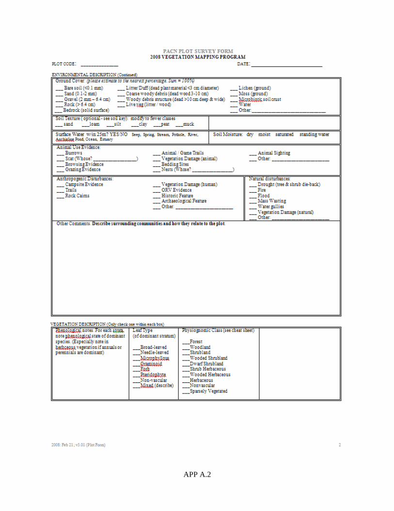
APP A.2

APP A.3

APP A.4

APP A.5

APP A.6

APP A.7


APP B.1
Appendix B: Plant Species Found within Sample Plots at Pu‘ukoholā Heiau National Historic Site Fifty-four plant species were encountered while sampling field plots, observation points, and accuracy assessment plots. Family, genus species, common names and nativity are reported. Plant species are indicated that were not present in sample plots at PUHE, but are important for community classification. Nomenclature follows that of Wagner and Herbst (2003) and Wagner et al. (1999) for flowering plants and Palmer (2003) for ferns. Common names listed were selected primarily from Wagner et al. (1999) by PACN and used throughout the document. Species names that differ from those in the rUSNVC are identified with footnotes.
Family Genus species Common Name Nativity
Agavaceae Cordyline fruticosa (L.) A. Chev. ti Non-Native
Aizoaceae Sesuvium portulacastrum (L.) L. ‘ākulikuli Native
Anacardiaceae Schinus terebinthifolius Raddi1 Christmas berry Non-Native
Arecaceae Cocos nucifera L. coconut palm Non-Native
Arecaceae Pritchardia affinis Becc. loulu Native
Asteraceae Aster sp. 1 Bataceae Batis maritima L. pickleweed Non-Native
Boraginaceae Cordia subcordata Lam. kou Native
Boraginaceae Heliotropium anomalum var. argenteum A. Gray hinahina Native
Boraginaceae Heliotropium curassavicum L. kīpūkai Native
Boraginaceae Tournefortia argentea L. fil. tree heliotrope Non-Native
Caricaceae Carica papaya L. papaya Non-Native
Chenopodiaceae Atriplex semibaccata R. Br. Australian saltbush Non-Native
Chenopodiaceae Atriplex suberecta Verd.
Non-Native
Clusiaceae Calophyllum inophyllum L. kamani Non-Native
Clusiaceae Clusia rosea Jacq. autograph tree Non-Native
Convolvulaceae Merremia aegyptia (L.) Urban hairy merremia Non-Native
Cyperaceae Bolboschoenus maritimus ssp. paludosus (A. Nels.) T. Koyama kaluhā Native
Cyperaceae Bulbostylis capillaris (L.) C. B. Clarke
Non-Native
Cyperaceae Cyperus javanicus Houtt. ‘ahu‘awa Native
Cyperaceae Kyllinga brevifolia Rottb.
Non-Native
Euphorbiaceae Aleurites moluccana (L.) Willd. kukui Non-Native
Euphorbiaceae Chamaesyce prostrata (Aiton) Small prostrate spurge Non-Native
Euphorbiaceae Chamaesyce sp. 1
Fabaceae Chamaecrista nictitans ssp. patellaria var. glabrata (Vogel) H. Irwin & Barneby partridge pea Non-Native
Fabaceae Desmodium sandwicense E. Mey. Spanish clover Non-Native
Fabaceae Desmodium triflorum (L.) DC.
Non-Native
Fabaceae Leucaena leucocephala (Lam.) de Wit koa haole Non-Native
Fabaceae Macroptilium lathyroides (L.) Urb. wild bean Non-Native
Fabaceae Medicago lupulina L. black medick Non-Native

APP B.2
Family Genus species
Common Name
Nativity
Fabaceae
Prosopis pallida (Humb. & Bonpl. ex Willd.) Kunth
kiawe
Non-Native
Fabaceae Samanea saman (Jacq.) Merr.1 monkeypod Non-Native
Fabaceae Senna occidentalis (L.) Link coffee senna Non-Native
Fabaceae Tamarindus indica L. tamarind Non-Native
Goodeniaceae Scaevola taccada (Gaertn.) Roxb.2 naupaka kahakai Native
Malvaceae Gossypium tomentosum Nutt. ex Seem. ma‘o Non-Native
Malvaceae Sida fallax Walp. ‘ilima Native
Malvaceae Thespesia populnea (L.) Sol. ex Correa milo Native
Nyctaginaceae Bougainvillea glabra Choisy1 bougainvillea Non-Native
Pandanaceae Pandanus tectorius S. Parkinson ex Z hala Native
Poaceae Axonopus fissifolius (Raddi) Kuhlm carpetgrass Non-Native
Poaceae Cenchrus ciliaris L.3 buffelgrass Non-Native
Poaceae Cynodon dactylon (L.) Pers.
Non-Native
Poaceae Eragrostis tenella (L.) P. Beauv. Ex Roem. & Schult lovegrass Non-Native
Poaceae Heteropogon contortus (L.) P. Beauv. Ex roem. & Schult.1 pili Native
Poaceae Paspalum conjugatum Bergius Hilo grass Non-Native
Poaceae Paspalum vaginatum Sw. seashore paspalum Non-Native
Poaceae Pennisetum clandestinum Chiov. kikuyu Non-Native
Poaceae Pennisetum setaceum (Forsk.) Chiov. fountain grass Non-Native
Poaceae Sporobolus africanus (Poir.) Robyns & Tournay rattail grass Non-Native
Poaceae Sporobolus sp. 1 Portulacaceae Portulaca oleracea L. pigweed Non-Native
Rubiaceae Morinda citrifolia L. noni Non-Native
Sterculiaceae Waltheria indica L. ‘uhaloa Native 1Species important for community types, but not sampled in vegetation plots at PUHE. 2Listed in rUSNVC as Scaevola sericea var. taccada. 3Listed in rUSNVC as Pennisetum ciliare. Literature Cited Palmer D. 2003. Hawai‘i’s ferns and fern allies. University of Hawai‘i Press, Honolulu. Wagner, W. L. and D. R. Herbst. 2003. Supplement to the Manual of flowering plants of Hawai‘i
in Manual of the flowering plants of Hawaii, revised edition. Volumes 1 and 2. University of Hawaii Press and Bishop Museum Special Publication 97, Honolulu. 1855-1918 pp.
Wagner, W. L., D. R. Herbst, and S. H. Sohmer. 1999. Manual of the flowering plants of Hawaii.
Revised edition. Volumes 1 and 2. University of Hawaii Press and Bishop Museum Press, Honolulu. 1919 pp.

APP C.1
Appendix C: Field Plot Crosswalk to Revised US National Vegetation Classification Associations At Pu‘ukoholā Heiau National Historic Site 26 plots and observation points were assigned to revised US National Vegetation Classification (rUSNVC) associations and park specials. A total of four rUSNVC associations, one “Park Special” and one cultural type were classified. Element codes are used by NatureServe and state Natural Heritage Programs to track nomenclature and status of rare plants, rare animals, and communities (“elements”). Park specials are indicated by “CEPS.” Nomenclature used by the rUSNVC follows Kartesz (1999) with Pacific Island modifications based on Wagner and Herbst (2003) and Wagner et al. (1999).
Plant Association Scientific Name Element Code No. of Samples Supporting Plots and Observation Points
Cocos nucifera Strand Woodland CEGL005402 1 PUHE.1005
Thespesia populnea / Sparse Understory Woodland CEGL005412 1
PUHE.1009
Prosopis pallida Coastal Dry Semi-natural Woodland CEGL008118 10
PUHE.0004, PUHE.0006 PUHE.0007, PUHE.0010 PUHE.1002, PUHE.1003 PUHE.1004, PUHE.1006 PUHE.1007, PUHE.1011
Cenchrus ciliaris Semi-natural Herbaceous Vegetation1 CEGL005407 12
PUHE.0003, PUHE.0005, PUHE.0008, PUHE.0009, PUHE.0011, PUHE.0014, PUHE.0015, PUHE.0016, PUHE.0017, PUHE.0018, PUHE.1008, PUHE.1010
Macroptilium lathyroides Herbaceous Vegetation [Park Special] CEPS009517 2
PUHE.0013, PUHE.1014
Cultural Map Class 2 PUHE.0001, PUHE.1015
1rUSNVC name modified based on Wagner and Herbst (2003) and Wagner et al. (1999).
Literature Cited Wagner, W. L. and D. R. Herbst. 2003. Supplement to the Manual of flowering plants of Hawai‘i
in Manual of the flowering plants of Hawaii, revised edition. Volumes 1 and 2. University of Hawaii Press and Bishop Museum Special Publication 97, Honolulu. 1855-1918 pp.
Wagner, W. L., D. R. Herbst, and S. H. Sohmer. 1999. Manual of the flowering plants of Hawaii.
Revised edition. Volumes 1 and 2. University of Hawaii Press and Bishop Museum Press, Honolulu. 1919 pp.


APP D.1
Appendix D: Field Key to the Vegetation of Pu‘ukoholā Heiau National Historic Sites, Hawai‘i The vegetation of Pu‘ukoholā Heiau National Historic Site (PUHE) was characterized using field data collected in 2008 under the National Park Service's National Vegetation Mapping Program. To assist in the accurate field identification of the plant associations or vegetation cover types described for PUHE, this dichotomous key has been developed from plot data. It includes all types in the PUHE Vegetation Classification plus several types described from other West Hawai‘i parks that were mapped, but not sampled at PUHE as well as a few map classes to help clarify the different vegetation types.
This key is structured to facilitate identification of vegetation types with one or a combination of dominant or diagnostic species, and in some cases, the key also relates types to their primary habitats and range within the Historic Site. Because of natural variation within vegetation types, it is possible that a community can be keyed using more than one of the physiognomic keys. For sites within ecotones (boundary or transition zones between vegetation types where diagnostic species intermix), it may be difficult to determine a definitive type. A mapped type may have small inclusions of other vegetation types.
How to use the key
The key can be used to identify at three hierarchical levels within the revised US National Vegetation Classification (rUSNVC). The broadest level is the Group, then Alliance and at the finest scale is the rUSNVC Association. The key focuses on the Association level with an occasional reference to the Group level, as needed to allow for unclassified types. However, when the association is identified, then the alliance and group are known because of the hierarchical nature of the rUSNVC (Table 10). This allows the user to determine which hierarchy level is appropriate.
Park Specials represent local vegetation types that differ significantly from existing rUSNVC association concepts, but lack enough data to develop into a new association. Park Special types are not officially included in the rUSNVC Hierarchy, but many times can be linked to the Group level for classification and mapping purposes (Table 10).
The key is divided into Sparse, Coastal Strand, and Inland (Woodland, Shrubland and Herbaceous Vegetation) Zones. Some vegetation types may occur in multiple zones, especially inland types extending to coast, so if the key is not working well try using other zones in key before assuming vegetation is not described. The name of each Association and Park Special are provided using both common names and scientific names for species as well as the map code in parentheses. If the type was mapped, but not sampled at the site then a description was not written and “(no description)” was also added to couplet.
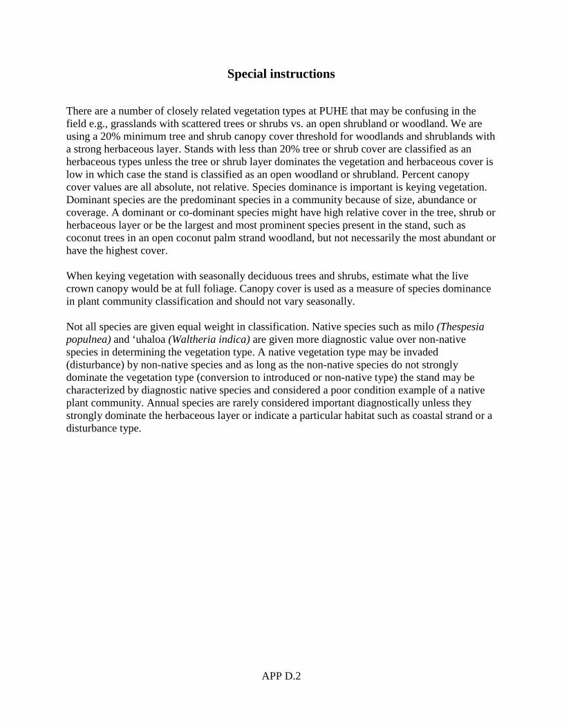
APP D.2
Special instructions
There are a number of closely related vegetation types at PUHE that may be confusing in the field e.g., grasslands with scattered trees or shrubs vs. an open shrubland or woodland. We are using a 20% minimum tree and shrub canopy cover threshold for woodlands and shrublands with a strong herbaceous layer. Stands with less than 20% tree or shrub cover are classified as an herbaceous types unless the tree or shrub layer dominates the vegetation and herbaceous cover is low in which case the stand is classified as an open woodland or shrubland. Percent canopy cover values are all absolute, not relative. Species dominance is important is keying vegetation. Dominant species are the predominant species in a community because of size, abundance or coverage. A dominant or co-dominant species might have high relative cover in the tree, shrub or herbaceous layer or be the largest and most prominent species present in the stand, such as coconut trees in an open coconut palm strand woodland, but not necessarily the most abundant or have the highest cover. When keying vegetation with seasonally deciduous trees and shrubs, estimate what the live crown canopy would be at full foliage. Canopy cover is used as a measure of species dominance in plant community classification and should not vary seasonally. Not all species are given equal weight in classification. Native species such as milo (Thespesia populnea) and ‘uhaloa (Waltheria indica) are given more diagnostic value over non-native species in determining the vegetation type. A native vegetation type may be invaded (disturbance) by non-native species and as long as the non-native species do not strongly dominate the vegetation type (conversion to introduced or non-native type) the stand may be characterized by diagnostic native species and considered a poor condition example of a native plant community. Annual species are rarely considered important diagnostically unless they strongly dominate the herbaceous layer or indicate a particular habitat such as coastal strand or a disturbance type.

APP D.3
A Key to the Vegetation Associations and Park-specific Map Classes at Pu‘ukoholā Heiau National Historic Site (PUHE) 1a) Land is developed or vegetation is absent or very sparse <2% cover (e.g., barren lava,
rocky or sandy shoreline) (See Geologic and Land Use Map Classes). 1b) Vegetation is present with sparse to dense cover (>2% total vegetation cover). (2) 2a) Site is sparsely vegetated (2-9% total vegetation cover). Site is too sparse to be considered
an open grassland, shrubland or woodland. (3) 2b) Vegetation is present with 10% or more total vegetation cover. (6) Sparse Vegetation 3a) Site is restricted to coastal shoreline. – Coastal Strand Sparse Vegetation [Park Special]
(SV_CS) (No description) 3b) Site is not restricted to coastal shoreline. (4) 4a) Site is restricted to lava flows. (5) 4b) Site is not restricted to lava flows. – Undescribed PUHE Sparse Vegetation 5a) Site is restricted to a‘a lava. – A‘a Lava with Sparse Vegetation [Park Special]
(SV_A‘A) (No description)
5b) Site is restricted to pahoehoe lava. – Pahoehoe Lava Sparse Vegetation (SV_PA) (No description)
Non-Sparse Vegetation 6a) Vegetation is restricted to the coastal shoreline and does not significantly extend into
coastal uplands. (7) 6b) Vegetation is not restricted to coastal shoreline. Some inland vegetation types occasionally
extend down to coastal strand (such as kiawe [Prosopis pallida] woodland). (12) Coastal Strand Vegetation 7a) Trees typically dominate strand vegetation. (8) 7b) Herbaceous or shrub vegetation typically dominates strand vegetation. (11) 8a) Vegetation is dominated or co-dominated by native or Polynesian introduced tree species.
(9) 8b) Vegetation is dominated by non-native tree species. (16) 9a) Vegetation is typically an open tree canopy dominated or co-dominated by the Polynesian
introduced coconut palm (Cocos nucifera). Includes stands down to 5% cover of coconut palm as long as it dominates the tree layer. – Coconut Palm Strand Woodland; Cocos nucifera Strand Woodland (W_CONU)
9b) Vegetation is not dominated or co-dominated by coconut palm (Cocos nucifera). (10)

APP D.4
10a) Vegetation is an open tree canopy dominated or co-dominated by milo (Thespesia populnea). The non-native kiawe (Prosopis pallida) may be present to co-dominant in tree layer. – Milo / Sparse Understory Woodland; Thespesia populnea / Sparse Understory Woodland (W_THPO)
10b) Vegetation is not dominated or co-dominated by milo (Thespesia populnea). – Undescribed PUHE vegetation in the Hawaiian Lowland Dry Forest & Woodland Group (G405)
11a) Vegetation is dominated or co-dominated by native herbaceous species. – Undescribed
PUHE vegetation in the Hawaiian Dry Scrub & Herb Coastal Strand Group (G421) 11b) Vegetation is dominated by non-native herbaceous species. – Undescribed PUHE
vegetation in the Hawaiian Ruderal Scrub & Herb Coastal Strand Group (G423) Inland Vegetation 12a) Vegetation is composed of trees or shrubs with at least 20% cover. Woody cover may be
lower (10-19%) as long as it exceeds any perennial herbaceous vegetation present. (13) 12b) Vegetation is dominated by grasses and/or broad-leaf herbs (forbs). Shrubs or trees may be
present, but tree or shrub cover is lower than perennial herbaceous layer and does not exceed 20%. (22)
13a) Vegetation is typically dominated by trees (usually >20% cover). Shrub cover may be high
(exceeding the tree cover) if tree cover is 20% or more. If tree cover is 10-19% then it must exceed shrub and perennial herbaceous cover (i.e. trees dominate the vegetation). Koa haole (Leucaena leucocephala) is considered to be a shrub and not a tree in this key. (14)
13b) Vegetation is typically dominated by shrubs (usually >20% cover). Trees may be present with less than 20% total cover. The shrub canopy may be less (10-20%) as long as it is greater than the perennial herbaceous cover. (19)
Woodlands 14a) Tree canopy is dominated or co-dominated by native trees. Sparse to dense shrubs may be
present, but trees dominate or have greater than 20% canopy cover. – Hawaiian Lowland Dry Forest & Woodland Group (G405) (15)
14b) Tree canopy is dominated by non-native trees. Sparse to dense shrubs may be present, but trees dominate or have greater than 20% canopy cover. – Hawaiian Ruderal Dry Forest Group (G407) (16)
15a) Vegetation is an open tree canopy dominated or co-dominated by milo (Thespesia
populnea). Kiawe (Prosopis pallida) may be present to co-dominant in the tree layer. – Milo / Sparse Understory Woodland; Thespesia populnea / Sparse Understory Woodland (W_THPO)
15b) Vegetation is dominated by other native tree species. – Undescribed PUHE vegetation in the Hawaiian Lowland Dry Forest & Woodland Group (G405)
16a) Tree canopy is dominated by koa haole (Leucaena leucocephala). In the rUSNVC, koa
haole is treated as a short to tall shrub, not a small tree even though some stands in Hawai‘i have tree form individuals. (21 ).

APP D.5
16b) Tree canopy is not dominated by koa haole (Leucaena leucocephala) although it may be present in the shrub layer. (17)
17a) Tree canopy is dominated or co-dominated by monkeypod (Samanea saman) and
Christmas berry (Schinus terebinthifolius). Kiawe (Prosopis pallida) may be present with low to moderate cover. – Monkeypod - Christmas Berry Semi-natural Woodland [Park Special]; Samanea saman - Schinus terebinthifolius Semi-natural Woodland [Park Special] (W_SASA) (No description)
17b) Tree canopy is not co-dominated by monkeypod (Samanea saman) and Christmas berry (Schinus terebinthifolius). (18)
18a) Tree canopy is dominated by kiawe (Prosopis pallida). – Kiawe Coastal Dry Semi-
natural Woodland; Prosopis pallida Coastal Dry Woodland (W_PRPA) 18b) Tree canopy is not dominated by kiawe (Prosopis pallida). Tree canopy is often dominated
by kukui (Aleurites moluccana) a Polynesian introduced species, papaya (Carica papaya) or other non-native tree species. – Mixed Semi-natural / Ornamental Tree Woodland (W_ORNA) (No description)
Shrublands 19a) Shrub canopy is dominated or co-dominated by native shrubs. – Undescribed PUHE
vegetation in the Hawaiian Lowland Dry Shrubland & Grassland Group (G410) 19b) Shrub canopy is dominated by non-native shrubs. – Hawaiian Ruderal Lowland
Shrubland, Grassland & Savanna Group (20) 20a) Shrub canopy is dominated by bougainvillea (Bougainvillea glabra). – Bougainvillea
Semi-natural / Planted Shrubland [Park Special]; Bougainvillea glabra Semi-natural / Planted Shrubland [Park Special] (S_BOGL) (No description)
20b) Vegetation is not dominated by bougainvillea (Bougainvillea glabra). (21) 21a) Shrub canopy is dominated or co-dominated by koa haole (Leucaena leucocephala). (This
species is generally considered a short (1-2 m tall) or tall shrub (2-5 m tall), but sometimes occurs as a small tree (>5m tall with single stem). However, regardless of life form (shrub or small tree) it is classified as a shrubland in the rUSNVC. Understory is a sparse or dense herbaceous layer that is not dominated by guinea grass (Panicum maximum) or fountain grass (Pennisetum setaceum). Monkeypod (Pithecellobium dulce) is absent or has low cover (not co-dominant). – Koa Haole Lowland Dry Semi-natural Shrubland; Leucaena leucocephala Lowland Dry Semi-natural Shrubland (S_LELE)
21b) Shrub canopy is dominated or co-dominated other non-native shrub species. – Undescribed PUHE vegetation in the Hawaiian Ruderal Lowland Shrubland, Grassland & Savanna Group (G413)
Herbaceous Vegetation 22a) Herbaceous layer is planted or part of a maintained landscaped area (cultural type). Species
may include native and non-native species. (23) 22b) Herbaceous layer is not planted. Species may include natives and non-native species. (24)

APP D.6
23a) Maintained landscaped area is dominated by the native species pili grass (Heteropogon
contortus). – Pili Planted Herbaceous Vegetation; Heteropogon contortus Planted Herbaceous Vegetation (H_HECO) (No description)
23b) Maintained landscaped area is dominated by non-native grass species such as Cynodon dactylon, Hilo grass (Paspalum conjugatum), and rattail grass (Sporobolus africanus). – Planted Grasses (L_LAWN) (No description)
24a) Vegetation is dominated or co-dominated by native herbaceous species. Stands may
include scattered trees or shrubs with up to 19% cover, as long as the herbaceous cover is greater than the woody cover. – Undescribed PUHE vegetation in the Hawaiian Lowland Dry Shrubland & Grassland Group (G410)
24b) Vegetation is dominated by non-native herbaceous species, but may include scattered trees or shrubs with up to 19% cover, as long as the herbaceous cover is greater than the woody cover. – Hawaiian Ruderal Lowland Shrubland, Grassland & Savanna Group (G413) (25)
25a) Vegetation is dominated or co-dominated by wild bean (Macroptilium lathyroides). – Wild
Bean Herbaceous Vegetation [Park Special]; Macroptilium lathyroides Herbaceous Vegetation [Park Special] (H_MALA)
25b) Vegetation is not dominated by wild bean (Macroptilium lathyroides). (26) 26a) Herbaceous layer is dominated by buffelgrass (Cenchrus ciliaris). – Buffelgrass
Herbaceous Semi-natural Vegetation; Cenchrus ciliaris Semi-natural Herbaceous Vegetation1 (H_CECI)
26b) Herbaceous layer is not dominated by buffelgrass (Cenchrus ciliaris). – Undescribed PUHE vegetation in the Hawaiian Ruderal Lowland Shrubland, Grassland & Savanna Group (G413)
1rUSNVC name modified based on Wagner and Herbst (2003) and Wagner et al. (1999).
Literature Cited Wagner, W. L. and D. R. Herbst. 2003. Supplement to the Manual of flowering plants of Hawai‘i
in Manual of the flowering plants of Hawaii, revised edition. Volumes 1 and 2. University of Hawaii Press and Bishop Museum Special Publication 97, Honolulu. 1855-1918 pp.
Wagner, W. L., D. R. Herbst, and S. H. Sohmer. 1999. Manual of the flowering plants of Hawaii.
Revised edition. Volumes 1 and 2. University of Hawaii Press and Bishop Museum Press, Honolulu. 1919 pp.

APP E.1
Appendix E: Plant Association Descriptions for Pu‘ukoholā Heiau National Historic Site, Hawai‘i
REVISED US NATIONAL VEGETATION CLASSIFICATION
Vegetation Associations of Pu‘ukoholā Heiau National Historic Site
23 September 2010
by
NatureServe
1101 Wilson Blvd., 15th floor Arlington, VA 22209
4001 Discovery, Suite 2110 Boulder, CO 80303
This subset of the International Ecological Classification Standard covers vegetation associations of Pu‘ukoholā Heiau National Historic Site. This classification has been developed in consultation with many individuals and agencies and incorporates information from a variety of publications and other classifications. Comments and suggestions regarding the contents of this subset should be directed to Mary J. Russo, Central Ecology Data Manager, Durham, NC [email protected], and/or Keith Schulz, Vegetation Ecologist, Boulder, CO [email protected].
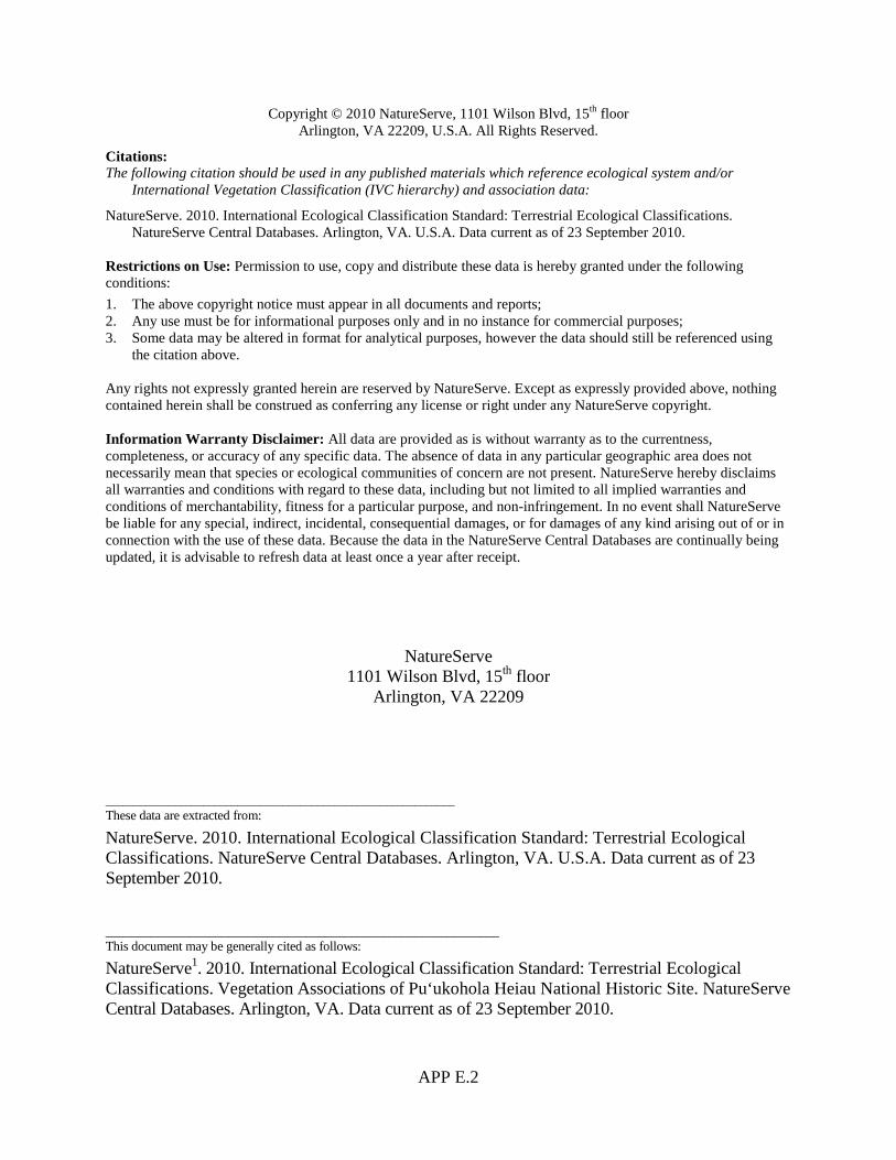
APP E.2
Copyright © 2010 NatureServe, 1101 Wilson Blvd, 15th floor Arlington, VA 22209, U.S.A. All Rights Reserved.
Citations: The following citation should be used in any published materials which reference ecological system and/or
International Vegetation Classification (IVC hierarchy) and association data:
NatureServe. 2010. International Ecological Classification Standard: Terrestrial Ecological Classifications. NatureServe Central Databases. Arlington, VA. U.S.A. Data current as of 23 September 2010.
Restrictions on Use: Permission to use, copy and distribute these data is hereby granted under the following conditions: 1. The above copyright notice must appear in all documents and reports; 2. Any use must be for informational purposes only and in no instance for commercial purposes; 3. Some data may be altered in format for analytical purposes, however the data should still be referenced using
the citation above. Any rights not expressly granted herein are reserved by NatureServe. Except as expressly provided above, nothing contained herein shall be construed as conferring any license or right under any NatureServe copyright. Information Warranty Disclaimer: All data are provided as is without warranty as to the currentness, completeness, or accuracy of any specific data. The absence of data in any particular geographic area does not necessarily mean that species or ecological communities of concern are not present. NatureServe hereby disclaims all warranties and conditions with regard to these data, including but not limited to all implied warranties and conditions of merchantability, fitness for a particular purpose, and non-infringement. In no event shall NatureServe be liable for any special, indirect, incidental, consequential damages, or for damages of any kind arising out of or in connection with the use of these data. Because the data in the NatureServe Central Databases are continually being updated, it is advisable to refresh data at least once a year after receipt.
NatureServe 1101 Wilson Blvd, 15th floor
Arlington, VA 22209
_____________________________________________________________ These data are extracted from:
NatureServe. 2010. International Ecological Classification Standard: Terrestrial Ecological Classifications. NatureServe Central Databases. Arlington, VA. U.S.A. Data current as of 23 September 2010. _____________________________________________________________ This document may be generally cited as follows:
NatureServe1. 2010. International Ecological Classification Standard: Terrestrial Ecological Classifications. Vegetation Associations of Pu‘ukohola Heiau National Historic Site. NatureServe Central Databases. Arlington, VA. Data current as of 23 September 2010.
APP E.3
1 NatureServe is an international organization including NatureServe regional offices, a NatureServe central office, U.S. State Natural Heritage Programs, and Conservation Data Centers (CDC) in Canada and Latin America and the Caribbean. Ecologists from the following organizations have contributed the development of the ecological systems classification: United States Central NatureServe Office, Arlington, VA; Eastern Regional Office, Boston, MA; Midwestern Regional Office, Minneapolis, MN; Southeastern Regional Office, Durham, NC; Western Regional Office, Boulder, CO; Alabama Natural Heritage Program, Montgomery AL; Alaska Natural Heritage Program, Anchorage, AK; Arizona Heritage Data Management Center, Phoenix AZ; Arkansas Natural Heritage Commission Little Rock, AR; Blue Ridge Parkway, Asheville, NC; California Natural Heritage Program, Sacramento, CA; Colorado Natural Heritage Program, Fort Collins, CO; Connecticut Natural Diversity Database, Hartford, CT; Delaware Natural Heritage Program, Smyrna, DE; District of Columbia Natural Heritage Program/National Capital Region Conservation Data Center, Washington DC; Florida Natural Areas Inventory, Tallahassee, FL; Georgia Natural Heritage Program, Social Circle, GA; Great Smoky Mountains National Park, Gatlinburg, TN; Gulf Islands National Seashore, Gulf Breeze, FL; Hawaii Natural Heritage Program, Honolulu, Hawaii; Idaho Conservation Data Center, Boise, ID; Illinois Natural Heritage Division/Illinois Natural Heritage Database Program, Springfield, IL; Indiana Natural Heritage Data Center, Indianapolis, IN; Iowa Natural Areas Inventory, Des Moines, IA; Kansas Natural Heritage Inventory, Lawrence, KS; Kentucky Natural Heritage Program, Frankfort, KY; Louisiana Natural Heritage Program, Baton Rouge, LA; Maine Natural Areas Program, Augusta, ME; Mammoth Cave National Park, Mammoth Cave, KY; Maryland Wildlife & Heritage Division, Annapolis, MD; Massachusetts Natural Heritage & Endangered Species Program, Westborough, MA; Michigan Natural Features Inventory, Lansing, MI; Minnesota Natural Heritage & Nongame Research and Minnesota County Biological Survey, St. Paul, MN; Mississippi Natural Heritage Program, Jackson, MI; Missouri Natural Heritage Database, Jefferson City, MO; Montana Natural Heritage Program, Helena, MT; National Forest in North Carolina, Asheville, NC; National Forests in Florida, Tallahassee, FL; National Park Service, Southeastern Regional Office, Atlanta, GA; Navajo Natural Heritage Program, Window Rock, AZ; Nebraska Natural Heritage Program, Lincoln, NE; Nevada Natural Heritage Program, Carson City, NV; New Hampshire Natural Heritage Inventory, Concord, NH; New Jersey Natural Heritage Program, Trenton, NJ; New Mexico Natural Heritage Program, Albuquerque, NM; New York Natural Heritage Program, Latham, NY; North Carolina Natural Heritage Program, Raleigh, NC; North Dakota Natural Heritage Inventory, Bismarck, ND; Ohio Natural Heritage Database, Columbus, OH; Oklahoma Natural Heritage Inventory, Norman, OK; Oregon Natural Heritage Program, Portland, OR; Pennsylvania Natural Diversity Inventory, PA; Rhode Island Natural Heritage Program, Providence, RI; South Carolina Heritage Trust, Columbia, SC; South Dakota Natural Heritage Data Base, Pierre, SD; Tennessee Division of Natural Heritage, Nashville, TN; Tennessee Valley Authority Heritage Program, Norris, TN; Texas Conservation Data Center, San Antonio, TX; Utah Natural Heritage Program, Salt Lake City, UT; Vermont Nongame & Natural Heritage Program, Waterbury, VT; Virginia Division of Natural Heritage, Richmond, VA; Washington Natural Heritage Program, Olympia, WA; West Virginia Natural Heritage Program, Elkins, WV; Wisconsin Natural Heritage Program, Madison, WI; Wyoming Natural Diversity Database, Laramie, WY Canada Alberta Natural Heritage Information Centre, Edmonton, AB, Canada; Atlantic Canada Conservation Data Centre, Sackville, New Brunswick, Canada; British Columbia Conservation Data Centre, Victoria, BC, Canada; Manitoba Conservation Data Centre. Winnipeg, MB, Canada; Ontario Natural Heritage Information Centre, Peterborough, ON, Canada; Quebec Conservation Data Centre, Quebec, QC, Canada; Saskatchewan Conservation Data Centre, Regina, SK, Canada; Yukon Conservation Data Centre, Yukon, Canada Latin American and Caribbean Centro de Datos para la Conservacion de Bolivia, La Paz, Bolivia; Centro de Datos para la Conservacion de Colombia, Cali,Valle, Columbia; Centro de Datos para la Conservacion de Ecuador, Quito, Ecuador; Centro de Datos para la Conservacion de Guatemala, Ciudad de Guatemala, Guatemala; Centro de Datos para la Conservacion de Panama, Querry Heights, Panama; Centro de Datos para la Conservacion de Paraguay, San Lorenzo, Paraguay; Centro de Datos para la Conservacion de Peru, Lima, Peru; Centro de Datos para la Conservacion de Sonora, Hermosillo, Sonora, Mexico; Netherlands Antilles Natural Heritage Program, Curacao, Netherlands Antilles; Puerto Rico-Departmento De Recursos Naturales Y Ambientales, Puerto Rico; Virgin Islands Conservation Data Center, St. Thomas, Virgin Islands. NatureServe also has partnered with many International and United States Federal and State organizations, which have also contributed significantly to the development of the International Classification. Partners include the following The Nature Conservancy; Provincial Forest Ecosystem Classification Groups in Canada; Canadian Forest Service; Parks Canada; United States Forest Service; National GAP Analysis Program; United States National Park Service; United States Fish and Wildlife Service; United States Geological Survey; United States Department of Defense; Ecological Society of America; Environmental Protection Agency; Natural Resource Conservation Services; United States Department of Energy; and the Tennessee Valley Authority. Many individual state organizations and people from academic institutions have also contributed to the development of this classification.

NPS Vegetation Inventory Program Pu‘ukoholā Heiau National Historic Site

NPS Vegetation Inventory Program Pu‘ukoholā Heiau National Historic Site
APP E.5
TABLE OF CONTENTS 1. Forest & Woodland .................................................................................................................. E.5
1.B.1. Tropical (Semi-) Deciduous Forest ............................................................................ E.5
1.B.1.Oc. Polynesian Dry Forest ................................................................................. E.5
M210. Hawaiian Dry Forest ........................................................................................ E.5
G405. Hawaiian Lowland Dry Forest & Woodland Group ..................................... E.6 Milo / Sparse Understory Woodland ............................................................... E.6
M213. Polynesian Ruderal Dry Forest......................................................................... E.6
G407. Hawaiian Ruderal Dry Forest Group ............................................................ E.7 Kiawe Coastal Dry Semi-natural Woodland.................................................... E.7
2. Shrubland & Grassland ............................................................................................................ E.8
2.A.1. Tropical Lowland Shrubland, Grassland & Savanna ................................................. E.8
2.A.1.Ol. Polynesian Lowland Shrubland, Grassland & Savanna ............................... E.8
M220. Polynesian Ruderal Lowland Shrubland, Grassland & Savanna ..................... E.8
G413. Hawaiian Ruderal Lowland Shrubland, Grassland & Savanna Group ......... E.8 Buffelgrass Semi-natural Herbaceous Vegetation ........................................... E.8 Wild Bean Semi-natural Herbaceous Vegetation [Park Special] .................... E.9
2.A.3. Tropical Scrub & Herb Coastal Vegetation ............................................................... E.9
2.A.3.Ob. Polynesian Scrub & Herb Coastal Vegetation ............................................ E.9
M231. Hawaiian Scrub & Herb Coastal Vegetation .................................................. E.10
G421. Hawaiian Dry Scrub & Herb Coastal Strand Group ................................... E.10 Coconut Palm Strand Woodland .................................................................... E.10
Bibliography .............................................................................................................................. E.11
1. Forest & Woodland 1.B.1. Tropical (Semi-) Deciduous Forest 1.B.1.Oc. Polynesian Dry Forest M210. Hawaiian Dry Forest
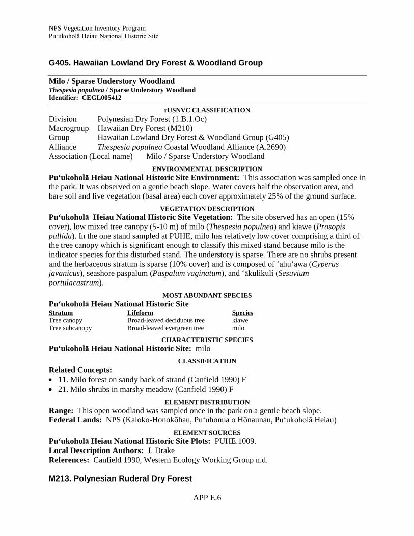
NPS Vegetation Inventory Program Pu‘ukoholā Heiau National Historic Site
APP E.6
G405. Hawaiian Lowland Dry Forest & Woodland Group
Milo / Sparse Understory Woodland Thespesia populnea / Sparse Understory Woodland Identifier: CEGL005412
rUSNVC CLASSIFICATION Division Polynesian Dry Forest (1.B.1.Oc) Macrogroup Hawaiian Dry Forest (M210) Group Hawaiian Lowland Dry Forest & Woodland Group (G405) Alliance Thespesia populnea Coastal Woodland Alliance (A.2690) Association (Local name) Milo / Sparse Understory Woodland
ENVIRONMENTAL DESCRIPTION Pu‘ukoholā Heiau National Historic Site Environment: This association was sampled once in the park. It was observed on a gentle beach slope. Water covers half the observation area, and bare soil and live vegetation (basal area) each cover approximately 25% of the ground surface.
VEGETATION DESCRIPTION Pu‘ukoholā Heiau National Historic Site Vegetation: The site observed has an open (15% cover), low mixed tree canopy (5-10 m) of milo (Thespesia populnea) and kiawe (Prosopis pallida). In the one stand sampled at PUHE, milo has relatively low cover comprising a third of the tree canopy which is significant enough to classify this mixed stand because milo is the indicator species for this disturbed stand. The understory is sparse. There are no shrubs present and the herbaceous stratum is sparse (10% cover) and is composed of ‘ahu‘awa (Cyperus javanicus), seashore paspalum (Paspalum vaginatum), and ‘ākulikuli (Sesuvium portulacastrum).
MOST ABUNDANT SPECIES Pu‘ukoholā Heiau National Historic Site Stratum Lifeform Species Tree canopy Broad-leaved deciduous tree kiawe Tree subcanopy Broad-leaved evergreen tree milo
CHARACTERISTIC SPECIES Pu‘ukoholā Heiau National Historic Site: milo
CLASSIFICATION Related Concepts: • 11. Milo forest on sandy back of strand (Canfield 1990) F • 21. Milo shrubs in marshy meadow (Canfield 1990) F
ELEMENT DISTRIBUTION Range: This open woodland was sampled once in the park on a gentle beach slope. Federal Lands: NPS (Kaloko-Honokōhau, Pu‘uhonua o Hōnaunau, Pu‘ukoholā Heiau)
ELEMENT SOURCES Pu‘ukoholā Heiau National Historic Site Plots: PUHE.1009. Local Description Authors: J. Drake References: Canfield 1990, Western Ecology Working Group n.d. M213. Polynesian Ruderal Dry Forest

NPS Vegetation Inventory Program Pu‘ukoholā Heiau National Historic Site
APP E.7
G407. Hawaiian Ruderal Dry Forest Group
Kiawe Coastal Dry Semi-natural Woodland Prosopis pallida Coastal Dry Semi-natural Woodland Identifier: CEGL008118
r USNVC CLASSIFICATION Division Polynesian Dry Forest (1.B.1.Oc) Macrogroup Polynesian Ruderal Dry Forest (M213) Group Hawaiian Ruderal Dry Forest Group (G407) Alliance Prosopis pallida Ruderal Woodland Alliance (A.2699) Association (Local name) Kiawe Coastal Dry Semi-natural Woodland
ENVIRONMENTAL DESCRIPTION Pu‘ukoholā Heiau National Historic Site Environment: This woodland was sampled at 10 sites in the park. It is found at low elevations (11-24 m) and on gentle lower slopes on recent lava flows or in drainage channels. The bedrock is a‘a or pahoehoe lava. The ground cover is variable, typically a mix of bare soil, bedrock, and litter with rocks prevalent in a few stands.
VEGETATION DESCRIPTION Pu‘ukoholā Heiau National Historic Site Vegetation: This association has an open, short-statured canopy. Few taxa were observed in the samples (range 2-6). The tree canopy averages 5-10 m tall with a few stands as short as 2-5 m and some as tall as 10-15 m. Average canopy cover is 40% with a range of 15-80%. Kiawe (Prosopis pallida) is the only species noted in the tree canopy. There is virtually no tree subcanopy or shrub strata. The herbaceous stratum varies from 10-50% cover. Buffelgrass (Cenchrus ciliaris) is the only common species.
MOST ABUNDANT SPECIES Pu‘ukoholā Heiau National Historic Site Stratum Lifeform Species Tree canopy Broad-leaved deciduous tree kiawe Herb (field) Graminoid buffelgrass
CHARACTERISTIC SPECIES Pu‘ukoholā Heiau National Historic Site: kiawe
CLASSIFICATION Related Concepts: • 12. Kiawe forest on sandy back of strand (Canfield 1990) F • 27. Kiawe inland forest on pahoehoe (Canfield 1990) F • Kiawe (Prosopis) Forest (Gagne and Cuddihy 1990)
ELEMENT DISTRIBUTION Range: This woodland is widespread in the park especially on recent lava flows or in drainage channels. Federal Lands: NPS (Kaloko-Honokōhau, Pu‘uhonua o Hōnaunau, Pu‘ukoholā Heiau)
ELEMENT SOURCES Pu‘ukoholā Heiau National Historic Site Plots: PUHE.0004, PUHE.0006, PUHE.0007, PUHE.0010, PUHE.1002, PUHE.1003, PUHE.1004, PUHE.1006, PUHE.1007, PUHE.1011. Local Description Authors: J. Drake

NPS Vegetation Inventory Program Pu‘ukoholā Heiau National Historic Site
APP E.8
References: Canfield 1990, Gagne and Cuddihy 1990, Wagner et al. 1999, Western Ecology Working Group n.d. 2. Shrubland & Grassland 2.A.1. Tropical Lowland Shrubland, Grassland & Savanna 2.A.1.Ol. Polynesian Lowland Shrubland, Grassland & Savanna M220. Polynesian Ruderal Lowland Shrubland, Grassland & Savanna G413. Hawaiian Ruderal Lowland Shrubland, Grassland & Savanna Group
Buffelgrass Semi-natural Herbaceous Vegetation Cenchrus ciliaris Semi-natural Herbaceous Vegetation1
Identifier: CEGL005407
r USNVC CLASSIFICATION Division Polynesian Lowland Shrubland, Grassland & Savanna (2.A.1.Ol) Macrogroup Polynesian Ruderal Lowland Shrubland, Grassland & Savanna (M220) Group Hawaiian Ruderal Lowland Shrubland, Grassland & Savanna Group (G413) Alliance (Cenchrus ciliaris - Pennisetum setaceum) - Mixed Medium-Tall Ruderal
Grassland Alliance (A.2693) Association (Local name) Buffelgrass Semi-natural HerbaceousVegetation
ENVIRONMENTAL DESCRIPTION Pu‘ukoholā Heiau National Historic Site Environment: This association had 12 samples taken in the park. It is found from sea level to 46 m in elevation and on gentle slopes of any aspect. The sites are dry, low slopes or low level areas, and nearly all are over recent a‘a or pahoehoe lava. The ground cover is variable but is typically a mix of bare soil, dead vegetation, rocks, and/or gravel.
VEGETATION DESCRIPTION Pu‘ukoholā Heiau National Historic Site Vegetation: This community has sparse or absent woody strata (10% average, 20% maximum tree canopy) composed of kiawe (Prosopis pallida). The herbaceous stratum is variable (10-80%). Buffelgrass (Cenchrus ciliaris) is the most abundant herbaceous species in every plot with an average cover of 40%. Other common taxa are lovegrass (Eragrostis tenella) and Asteraceae spp. No other taxa were found in more than two of the 12 plots or have more than 8% cover.
MOST ABUNDANT SPECIES Pu‘ukoholā Heiau National Historic Site Stratum Lifeform Species Herb (field) Graminoid buffelgrass
CHARACTERISTIC SPECIES Pu‘ukoholā Heiau National Historic Site: buffelgrass
ELEMENT DISTRIBUTION Range: This community occurs widely at this historic site on a variety of especially recent lava. Federal Lands: NPS (Pu‘ukoholā Heiau)

NPS Vegetation Inventory Program Pu‘ukoholā Heiau National Historic Site
APP E.9
ELEMENT SOURCES Pu‘ukoholā Heiau National Historic Site Plots: PUHE.0003, PUHE.0005, PUHE.0008, PUHE.0009, PUHE.0011, PUHE.0014, PUHE.0015, PUHE.0016, PUHE.0017, PUHE.0018, PUHE.1008, PUHE.1010. Local Description Authors: J. Drake References: Western Ecology Working Group n.d.
Wild Bean Herbaceous Vegetation [Park Special] Macroptilium lathyroides Herbaceous Vegetation [Park Special] Identifier: CEPS009517
r USNVC CLASSIFICATION Division Polynesian Lowland Shrubland, Grassland & Savanna (2.A.1.Ol) Macrogroup Polynesian Ruderal Lowland Shrubland, Grassland & Savanna (M220) Group Hawaiian Ruderal Lowland Shrubland, Grassland & Savanna Group (G413) Alliance na Association (Local name) Wild Bean Herbaceous Vegetation [Park Special]
ENVIRONMENTAL DESCRIPTION Pu‘ukoholā Heiau National Historic Site Environment: This association had two samples taken in the park. It is found on gentle low and midslopes near sea level over a‘a lava. Disturbance appears important to the type as both sampled sites were disturbed. The unvegetated surface is mostly bare soil and rocks.
VEGETATION DESCRIPTION Pu‘ukoholā Heiau National Historic Site Vegetation: This community is dominated by herbaceous species. The herbaceous stratum averages 20% cover. Two taxa are common: Asteraceae spp. and wild bean (Macroptilium lathyroides). Partridge pea (Chamaecrista nictitans var. glabrata), Bulbostylis capillaris, buffelgrass (Cenchrus ciliaris), and lovegrass (Eragrostis tenella) are present in very small amounts.
MOST ABUNDANT SPECIES Pu‘ukoholā Heiau National Historic Site Stratum Lifeform Species Herb (field) Forb wild bean
CHARACTERISTIC SPECIES Pu‘ukoholā Heiau National Historic Site: wild bean
ELEMENT DISTRIBUTION Range: This herbaceous community is found on disturbed sites including a streambed and over a‘a lava. Federal Lands: NPS (Pu‘ukoholā Heiau)
ELEMENT SOURCES Pu‘ukoholā Heiau National Historic Site Plots: PUHE.0013, PUHE.0014. Local Description Authors: J. Drake References: Western Ecology Working Group n.d. 2.A.3. Tropical Scrub & Herb Coastal Vegetation 2.A.3.Ob. Polynesian Scrub & Herb Coastal Vegetation

NPS Vegetation Inventory Program Pu‘ukoholā Heiau National Historic Site
APP E.10
M231. Hawaiian Scrub & Herb Coastal Vegetation G421. Hawaiian Dry Scrub & Herb Coastal Strand Group
Coconut Palm Strand Woodland Cocos nucifera Strand Woodland Identifier: CEGL005402
r USNVC CLASSIFICATION Division Polynesian Scrub & Herb Coastal Vegetation (2.A.3.Ob) Macrogroup Hawaiian Scrub & Herb Coastal Vegetation (M231) Group Hawaiian Dry Scrub & Herb Coastal Strand Group (G421) Alliance Cocos nucifera Coastal Woodland Alliance (A.2691) Association (Local name) Coconut Palm Strand Woodland
ENVIRONMENTAL DESCRIPTION Pu‘ukoholā Heiau National Historic Site Environment: This woodland was sampled at one observation point in the park. The site is a flat beach at essentially sea level. The surface of the ground is bare soil (60% cover), bedrock (30%), and a small amount of litter, rocks, and gravel.
VEGETATION DESCRIPTION Pu‘ukoholā Heiau National Historic Site Vegetation: This community has low overall cover with a total vegetation cover of 15-20%. The canopy of this woodland is very open (10%) and 10-15 m tall. This stratum is co-dominated by coconut palm (Cocos nucifera) and kiawe (Prosopis pallida). There is a very open (5-10%) tree subcanopy 5-10 m tall as well, with milo (Thespesia populnea) and hala (Pandanus tectorius). Naupaka kahakai (Scaevola taccada) was noted for the short-shrub stratum at 1% cover. The herbaceous stratum is similarly sparse with pickleweed (Batis maritima), buffelgrass (Cenchrus ciliaris), and ‘ākulikuli (Sesuvium portulacastrum) each having 1% cover.
MOST ABUNDANT SPECIES Pu‘ukoholā Heiau National Historic Site Stratum Lifeform Species Tree canopy Broad-leaved deciduous tree kiawe Tree canopy Palm tree coconut palm Tree subcanopy Broad-leaved deciduous tree hala Tree subcanopy Broad-leaved evergreen tree milo Short shrub/sapling Broad-leaved evergreen shrub naupaka kahakai Herb (field) Semi-shrub pickleweed Herb (field) Forb ‘ākulikuli Herb (field) Graminoid buffelgrass
CHARACTERISTIC SPECIES Pu‘ukoholā Heiau National Historic Site: coconut palm, kiawe
CLASSIFICATION Related Concepts: • 14. Coconut grove on recently inhabited sandy ground (Canfield 1990)
ELEMENT DISTRIBUTION Range: This open woodland occurs along the coast in the park. Federal Lands: NPS (Kaloko-Honokōhau, Pu‘uhonua o Hōnaunau, Pu‘ukoholā Heiau)
NPS Vegetation Inventory Program Pu‘ukoholā Heiau National Historic Site
APP E.11
ELEMENT SOURCES Pu‘ukoholā Heiau National Historic Site Plots: PUHE.1005. Local Description Authors: J. Drake References: Canfield 1990, NatureServe n.d. 1rUSNVC name modified based on Wagner and Herbst (2003) and Wagner et al. (1999). Bibliography Canfield, J. E. 1990. Description and map of the plant communities of the Kaloko-Honokohau
National Cultural Park. University of Hawaii Cooperative National Park Resources Studies Unit Technical Report 73, Department of Botany, University of Hawaii, Honolulu. 29 pp.
Gagne, W. C., and L. W. Cuddihy. 1990. Vegetation. Pages 45-114 in: W. L. Wagner, D. R.
Herbst, and S. H. Sohmer, editors. Manual of the Flowering Plants of Hawaii. 2 volumes. University of Hawaii Press, Honolulu.
NatureServe. No date. International Ecological Classification Standard: International Vegetation
Classification. Central Databases. NatureServe, Arlington, VA. Wagner, W. L. and D. R. Herbst. 2003. Supplement to the Manual of flowering plants of Hawai‘i
in Manual of the flowering plants of Hawaii, revised edition. Volumes 1 and 2. University of Hawaii Press and Bishop Museum Special Publication 97, Honolulu. 1855-1918 pp.
Wagner, W. L., D. R. Herbst, and S. H. Sohmer. 1999. Manual of the flowering plants of Hawaii.
Revised edition. Volumes 1 and 2. University of Hawaii Press and Bishop Museum Press, Honolulu. 1919 pp.
Western Ecology Working Group of NatureServe. No date. International Ecological
Classification Standard: International Vegetation Classification. Terrestrial Vegetation. NatureServe, Boulder, CO.

NPS Vegetation Inventory Program Pu‘ukoholā Heiau National Historic Site

NPS Vegetation Inventory Program Pu‘ukoholā Heiau National Historic Site
APP F.1
Appendix F: Mapping Conventions and Visual Key Pu‘ukoholā Heiau National Historic Site - Map Units
This appendix describes the map units for the Pu‘ukoholā Heiau National Historic Site (PUHE) Vegetation Inventory Project. Its purpose is to: Describe the vegetation of each map unit; Provide a representative ground photograph/image for each map unit; Describe the link between each map unit and the revised U.S. National Vegetation
Classification (rUSNVC); Provide visual examples of each map unit with digital overhead images and delineated
overlays. The map units for PUHE were based on a combination of rUSNVC plant associations, local requests (i.e. Park Specials), the limitations of the digital imagery, and land use / land cover classes. The vegetation described in this section reflects the classification designed specifically for this project. Non-vegetated and land-use map units are not described in this key. For more information on the development of the mapping scheme for PUHE please reference the mapping sections of this report and the digital information (i.e. lookup tables, metadata) included on the project DVD. This key follows the physiognomic grouping of each map unit starting with woodland types. Each map unit is fully described by a variety of characteristics and features. First the rUSNVC crosswalk (if applicable) to associations and the common plant species for each association are presented. Next is a description of the mapping concept and a representative ground photograph. A map of the distribution for each mapping unit across the study area follows along with an example of the 2006 Quickbird digital basemap ortho-imagery (color infrared bands). The imagery snapshot examples also include representative polygon outlines that highlight the map unit signatures. Many of the map unit descriptions rely heavily on the vegetation plot data collected in 2008. The sample ground photographs were taken during the 2008 plot data collection or during the 2009 accuracy assessment by National Park Service staff.

NPS Vegetation Inventory Program Pu‘ukoholā Heiau National Historic Site
APP F.2
Woodlands Map Code Coconut Palm Strand Woodland W_CONU Cocos nucifera Strand Woodland
Common Species coconut palm (Cocos nucifera) naupaka kahakai (Scaevola taccada) kiawe (Prosopis pallida) buffelgrass (Cenchrus ciliaris) hala (Pandanus tectorius) rUSNVC Association - Cocos nucifera Strand Woodland Description Stands of coconut palms were rare at PUHE and primarily occurred in the Pelekane area and in the Samuel M. Spencer Park. In these areas the coconuts were likely planted at one time or are descendants of one’s planted by early Hawaiians. On the Quickbird imagery the coconut trees had a characteristic, dark red fan appearance due to their sparse canopy and the spreading of their fronds. This type likely occurred with trees from the other woodland map units and some single coconut trees were probably mapped with these other classes.
Representative Ground Photo
Photo Signature Example Range and Distribution

NPS Vegetation Inventory Program Pu‘ukoholā Heiau National Historic Site
APP F.3
Map Code Mixed Semi-natural / Ornamental Tree Woodland W_ORNA Common Species ‘opiuma (Pithecellobium dulce) papaya (Carica papaya) buffelgrass (Cenchrus ciliaris) monkeypod (Samanea saman) rUSNVC Association - No Association – Unclassified Map Unit Description The Mixed Semi-natural / Ornamental Tree Woodland map class was used to map managed areas that were likely planted with a mixture of native and ornamental trees. This catch-all category was only used outside of PUHE in the Samuel M. Spencer Park where no plot data were collected. The trees in this map class exhibited a range of signatures related to closed canopy or single large, spreading trees. Most of the canopies were bright red with a mottled appearance when viewed with the color infrared bands of the Quickbird imagery. More plot and verification data in these areas may warrant creating new woodland associations or merging this type with other existing woodland classes.
Photo Signature Example Range and Distribution
Representative Ground Photo

NPS Vegetation Inventory Program Pu‘ukoholā Heiau National Historic Site
APP F.4
Map Code Kiawe Coastal Dry Semi-natural Woodland W_PRPA Prosopis pallida Coastal Dry Semi-natural Woodland Common Species kiawe (Prosopis pallida) buffelgrass (Cenchrus ciliaris) koa haole (Leucaena leucocephala) fountain grass (Pennisetum setaceum) rUSNVC Association - Prosopis pallida Coastal Dry Semi-natural Woodland Description This widespread class was very common in PUHE and surrounding areas. Kiawe trees where the diagnostic species exhibiting a dark red, mottled signature on the color infrared imagery. Stands of this type ranged in both density and height with some of the stands in the northern portion of the park forming closed canopy, tall forests. Elsewhere, the kiawe was less dense and grew more as sparse shrubs.
Photo Signature Example Range and Distribution
Representative Ground Photos

NPS Vegetation Inventory Program Pu‘ukoholā Heiau National Historic Site
APP F.5
Map Code Monkeypod – Christmas Berry Semi-natural Woodland W_SASA Samanea saman - Schinus terebinthifolius Semi-natural Woodland Common Species monkeypod (Samanea saman) Christmas berry (Schinus terebinthifolius) kiawe (Prosopis pallida) coconut palm (Cocos nucifera) naupaka kahakai (Scaevola taccada) buffelgrass (Cenchrus ciliaris) rUSNVC Association - Samanea saman - Schinus terebinthifolius Semi-natural Woodland [Park Special] Description The Monkeypod – Christmas Berry Semi-natural Woodland type was used to map managed areas that contained either escaped or planted non-native trees. This category was only used outside of PUHE in the Samuel M. Spencer Park where no plot data were collected. This map class differed from the Mixed Semi-natural / Ornamental Tree Woodland class in that most of the trees were verified as monkeypods. Most of the canopies were red to pink with a mottled appearance when viewed with the color infrared bands of the Quickbird imagery. More monkeypod trees may exist in the project area but were probably mapped as one of the other woodland map classes.
Photo Signature Example Range and Distribution
Representative Ground Photo

NPS Vegetation Inventory Program Pu‘ukoholā Heiau National Historic Site
APP F.6
Map Code Milo / Sparse Understory Woodland W_THPO Thespesia populnea / Sparse Understory Woodland Common Species milo (Thespesia populnea) naupaka kahakai (Scaevola taccada) buffelgrass (Cenchrus ciliaris) rUSNVC Association - Thespesia populnea / Sparse Understory Woodland (Photo from KAHO) Description Milo trees were found throughout the study area with concentrations occurring in the Pelekane area and in the Samuel M. Spencer Park. Milo was fairly common along the coast where it tended to intermingle with coconut and kiawe map classes. Some polygons of this type likely include planted or restored areas that are actively being managed. On the color infrared imagery trees of this type had a characteristic pink to light red signature and the texture of the canopy was smoother than the other woodland types.
Photo Signature Example Range and Distribution
Representative Ground Photo

NPS Vegetation Inventory Program Pu‘ukoholā Heiau National Historic Site
APP F.7
Shrublands Map Code Bougainvillea Semi-natural / Planted Shrubland S_BOGL Bougainvillea glabra Semi-natural / Planted Shrubland Common Species bougainvillea (Bougainvillea glabra) buffelgrass (Cenchrus ciliaris) rUSNVC Association - Bougainvillea glabra Semi-natural / Planted Shrubland [Park Special] (Photo from KAHO) Description This rare type only occurred as a long band of shrubs adjacent to the road in Samuel M. Spencer Park. Although this type was not sampled it was verified in the field. Bougainvillea shrubs are common roadside plantings and it is likely that this polygon represents managed shrubs as well. On the color infrared imagery this type appeared as short-statured shrubs exhibiting a light pink, almost orange signature. Individual bougainvillea shrubs may also occur in other areas around PUHE (especially roadsides) but no other stands were seen on the 2006 imagery.
Photo Signature Example Range and Distribution
Representative Ground Photo

NPS Vegetation Inventory Program Pu‘ukoholā Heiau National Historic Site
APP F.8
Map Code Koa Haole Lowland Dry Semi-natural Shrubland S_LELE Leucaena leucocephala Lowland Dry Semi-natural Shrubland Common Species koa haole (Leucaena leucocephala) kiawe (Prosopis pallida) buffelgrass (Cenchrus ciliaris) fountain grass (Pennisetum setaceum) rUSNVC Association - Leucaena leucocephala Lowland Dry Semi-natural Shrubland (Photo from PUHO) Description Koa haole shrublands were fairly common in drainage ditches and disturbed areas in the northeast corner of PUHE extending southeast along the highway. Polygons of this type were usually surrounding by large stands of kiawe and buffelgrass likely representing disturbance gradients or ecotones. Where it did occur as pure stands, the koa haole shrubs were visible on the color infrared imagery as small, black, circular stands against a bluish background. Koa haole was also mapped as part of the kiawe map class where it was one of the dominant understory species. Photo Signature Example Range and Distribution
Representative Ground Photo

NPS Vegetation Inventory Program Pu‘ukoholā Heiau National Historic Site
APP F.9
Herbaceous Vegetation Map Code Pili Planted Herbaceous Vegetation H_HECO Heteropogon contortus Planted Herbaceous Vegetation Common Species pili (Heteropogon contortus) rUSNVC Association - No Association – Unclassified Map Unit (Photo from KAHO) Description Pili grass was likely the dominant grass species at PUHE in historic times before the arrival of Europeans and the introduction of buffelgrass. Today, pili is actively being restored to some areas of PUHE and this map class represents one known area of reintroduction. In addition to this polygon, pili grass was also found in some of the newly landscaped areas around the new visitor center and parking lot. This type was mapped primarily from ground observations and as such, had no characteristic signature to reliably map from. More ground-truthing and updating of this type should occur in the future to better inventory it and monitor its spread.
Photo Signature Example Range and Distribution
Representative Ground Photo

NPS Vegetation Inventory Program Pu‘ukoholā Heiau National Historic Site
APP F.10
Map Code Planted Grasses H_LAWN Common Species carpetgrass (Axonopus fissifolius) Cynodon dactylon buffelgrass (Cenchrus ciliaris) rUSNVC Association - No Association – Unclassified Map Unit Description The planted grasses map class was used to map managed areas around the PUHE’s headquarters and maintained lawns in the Samuel M. Spencer Park. These areas are regularly irrigated resulting in lush green lawns that contrast starkly with this arid landscape. The greenness of the lawns represents actively growing plants resulting in smooth, bright pink areas on the color infrared imagery.
Photo Signature Example Range and Distribution
Representative Ground Photo

NPS Vegetation Inventory Program Pu‘ukoholā Heiau National Historic Site
APP F.11
Map Code Wild Bean Herbaceous Vegetation H_MALA Macroptilium lathyroides Herbaceous Vegetation Common Species wild bean (Macroptilium lathyroides) buffelgrass (Cenchrus ciliaris) Aster sp. ‘uhaloa (Waltheria indica) ‘ilima (Sida fallax) lovegrass (Eragrostis tenella) rUSNVC Association - Macroptilium lathyroides Herbaceous Vegetation [Park Special] Description This map class represents a mixed weedy site adjacent to the Samuel M. Spencer Park. This area was sampled and the wild bean was seen as the dominant species at the time of the data collection. It is likely that this type is similar to the buffelgrass map class and other areas containing wild bean may have been inadvertently mapped as buffelgrass. This type was mapped primarily from ground observations and as such, had no characteristic signature to reliably map from. More ground-truthing and updating of this type should occur in the future to better inventory it and monitor its spread.
Photo Signature Example Range and Distribution
Representative Ground Photo

NPS Vegetation Inventory Program Pu‘ukoholā Heiau National Historic Site
APP F.12
Map Code Buffelgrass Semi-natural Herbaceous Vegetation H_CECI Cenchrus ciliaris Semi-natural Herbaceous Vegetation Common Species buffelgrass (Cenchrus ciliaris) kiawe (Prosopis pallida) koa haole (Leucaena leucocephala) rUSNVC Association - Cenchrus ciliaris Semi-natural Herbaceous Vegetation (rUSNVC name modified based on On Wagner and Herbst (2003) and Wagner et al. (1999)) Description Buffelgrass dominates vegetation at PUHE where it was found to occur on over 50% of the landscape. Buffelgrass formed large almost monotypic stands that varied in density based on moisture levels, soil type and topographic positions. On more developed soils and in drainage bottoms, buffelgrass was dense and grew up to 67cm (2 ft) tall. On broken lava buffelgrass tended to be sparse and stunted. Due to the lack of moisture, buffelgrass was senescent at the time of the imagery and appeared as smooth, yellow to white polygons. Where it was sparse the lava substrate signature on the color infrared imagery (dark blue-black) was more pronounced.
Photo Signature Example Range and Distribution
Representative Ground Photo
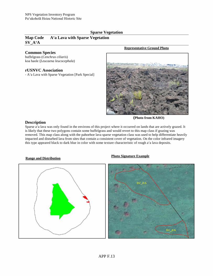
NPS Vegetation Inventory Program Pu‘ukoholā Heiau National Historic Site
APP F.13
Sparse Vegetation Map Code A‘a Lava with Sparse Vegetation SV_A‘A Common Species buffelgrass (Cenchrus ciliaris) koa haole (Leucaena leucocephala) rUSNVC Association - A‘a Lava with Sparse Vegetation [Park Special] (Photo from KAHO) Description Sparse a‘a lava was only found in the environs of this project where it occurred on lands that are actively grazed. It is likely that these two polygons contain some buffelgrass and would revert to this map class if grazing was removed. This map class along with the pahoehoe lava sparse vegetation class was used to help differentiate heavily impacted and disturbed lava from sites that contain a consistent cover of vegetation. On the color infrared imagery this type appeared black to dark blue in color with some texture characteristic of rough a‘a lava deposits.
Photo Signature Example Range and Distribution
Representative Ground Photo

NPS Vegetation Inventory Program Pu‘ukoholā Heiau National Historic Site
APP F.14
Map Code Coastal Strand Sparse Vegetation SV_CS Common Species ‘ākulikuli (Sesuvium portulacastrum) pickleweed (Batis maritima) buffelgrass (Cenchrus ciliaris) ‘uhaloa (Waltheria indica) ‘ilima (Sida fallax) rUSNVC Association - Coastal Strand Sparse Vegetation [Park Special] Description The Coastal Strand Sparse Vegetation map class was used to map one polygon in the Pelekane area and a few small polygons in the Samuel M. Spencer Park. This broad catch-all class was used since no clear dominant species was established and since these sites likely vary in vegetation composition yearly and seasonally. Plant species of this type also likely occur as understory constituents within the coconut palm and milo map units. On the color infrared imagery this type appeared as a light pink to brown haze on a white (sand) or blue (lava) background. More plot and verification data in these areas may warrant creating a new herbaceous association or merging this type with other existing associations.
Photo Signature Example Range and Distribution
Representative Ground Photo

NPS Vegetation Inventory Program Pu‘ukoholā Heiau National Historic Site
APP F.15
Map Code Pahoehoe Lava Sparse Vegetation SV_PA Common Species buffelgrass (Cenchrus ciliaris) koa haole (Leucaena leucocephala) rUSNVC Association - No Association – Unclassified Map Unit (Photo from KAHO) Description Sparse pahoehoe lava was similar in appearance to the a‘a sparse vegetated class in that it showed visible signs of disturbance either from development or grazing in the environs. Within PUHE, this map class was used to map restoration areas that appeared heavily disturbed in 2006. Since then, these sites may have been converted to pili or been invaded by buffelgrass. On the color infrared imagery this type exhibited a characteristic smooth, deep blue signature with some whitish streaks (sand or other deposits).
Photo Signature Example Range and Distribution
Representative Ground Photo

APP F.16
BARREN B_BE Beaches B_CB Coastal Basalt
B_DL Developed Lava B_ER Exposed Reef and Tidal Pools

APP F.17
B_PA Pahoehoe Lava
B_ROCK Bare Rock / Sand
LAND COVER – LAND USE L_BAY Bay / Estuary
L_CANL Canal / Ditch
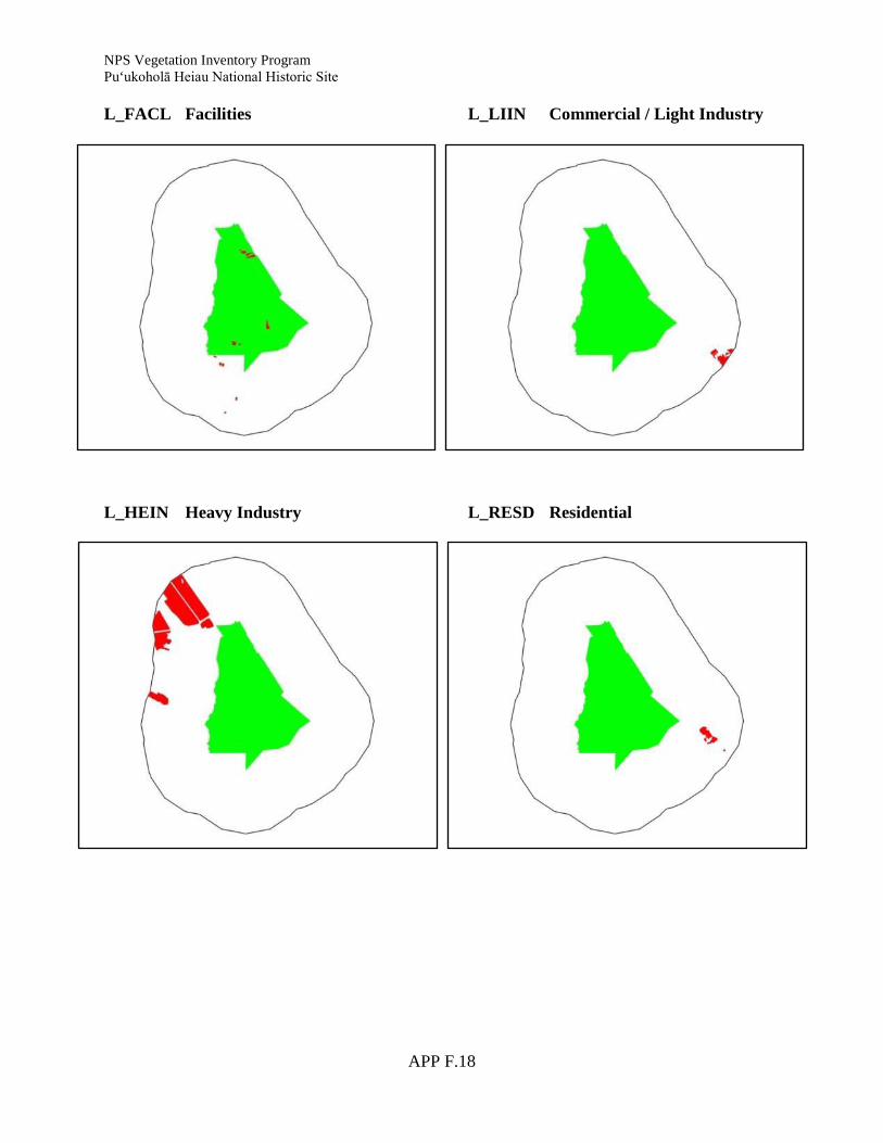
NPS Vegetation Inventory Program Pu‘ukoholā Heiau National Historic Site
APP F.18
L_FACL Facilities L_HEIN Heavy Industry
L_LIIN Commercial / Light Industry L_RESD Residential

NPS Vegetation Inventory Program Pu‘ukoholā Heiau National Historic Site
APP F.19
L_ROAD Transportation L_SEA Sea / Ocean
L_STRM Stream / River L_TRAN Transitional

NPS Vegetation Inventory Program Pu‘ukoholā Heiau National Historic Site
APP F.20
L_URBN Mixed Urban
Literature Cited Wagner, W. L. and D. R. Herbst. 2003. Supplement to the Manual of flowering plants of Hawai‘i
in Manual of the flowering plants of Hawaii, revised edition. Volumes 1 and 2. University of Hawaii Press and Bishop Museum Special Publication 97, Honolulu. 1855-1918 pp.
Wagner, W. L., D. R. Herbst, and S. H. Sohmer. 1999. Manual of the flowering plants of Hawaii.
Revised edition. Volumes 1 and 2. University of Hawaii Press and Bishop Museum Press, Honolulu. 1919 pp.

APP G.1
Appendix G: Final PUHE Vegetation Map


The Department of the Interior protects and manages the nation’s natural resources and cultural heritage; provides scientific and other information about those resources; and honors its special responsibilities to American Indians, Alaska Natives, and affiliated Island Communities. NPS 454/110578, September 2011

National Park Service U.S. Department of the Interior
Natural Resource Stewardship and Science 1201 Oakridge Drive, Suite 150 Fort Collins, CO 80525 www.nature.nps.gov
EXPERIENCE YOUR AMERICA TM