public informational presentation on the revised beach ......•presentation made to realtors...
TRANSCRIPT

Welcome!
Agenda • Introductions – Michael Powell
• Presentations:
• Beach Regulations: Why, How and What? – Jennifer Luoma
• New and Revised Applications – David Warga
• Questions/Open Discussion
BEACH REGULATIONS:
WHY, HOW AND WHAT? DNREC
Division of Watershed Stewardship
Shoreline and Waterway Management Section

Beaches and Dunes are Important
Natural Resources

Beaches and Dunes are areas used for
recreation.

Beaches and Dunes are important
habitats.

Dunes also act as natural barriers
and supply sand to the beaches
during coastal storms.

The History of the
Beach Preservation Act
and the Regulations
Governing Beach
Protection and the Use
of Beaches

March
1962

General Assembly recognized that Delaware’s
beaches were rapidly deteriorating due to a
combination of both natural processes and
continual encroachment of man.
Declared the beaches to be “valuable natural
features which provides recreational
opportunities and storm protection for persons
and property”...
Beach Preservation Act in 1972
Title 7, Chapter 68

“Development and habitation of the beaches must
be done with due consideration given to the
natural forces impacting upon them and the
dynamic nature of those natural features”
Our Charge
To enhance, preserve and protect the
public and private beaches of the
State.
To mitigate beach erosion and
minimize storm damage

Changes to the
Beach
Preservation Act
Updates to the Regulations
Governing Beach Protection
and the Use of Beaches

• July 26, 1973 - Adopted interim regulations
• May 6, 1974 -Regulations Governing Beach
Protection and the Use of Beaches
• August 13, 1981-Regulations were revised,
which incorporated the mapped building line
• December 27, 1983 – Revised Regulations
Adopted

Between 1983 and 2016
there were several changes to the
Beach Preservation Act

Amendment to the Beach Preservation Act :
• redefined “Beach”
• added definitions
• incorporated the building line concept of regulating
• defined the power to enhance, preserve, and protect
private beaches to include the prevention and repair
of damage from erosion in an emergency
• revised the penalty provisions
July 17, 1984

April 30, 1996
Amendment to the Beach Preservation Act:
Amendment made clear that in commercialized areas of
Rehoboth Beach and Bethany Beach which contain no
natural dune system, the building line shall be consistent
with the line of construction establish by existing
structures i.e. the boardwalk.

June 27, 1996
Amendment to the Beach Preservation
Act:
Subsection 6805(d)
“If any structure proposed to be built in whole or in
part seaward of the building line could reasonably be
reduced in size or otherwise altered in order to
eliminate or diminish the amount of encroachment
over the building line, the Department shall require
such reduction or alteration as a condition of granting
the permit or letter of approval.”
This led to the 4-step process.

In 2005 DNREC made
efforts to incorporate all
changes from Beach
Preservation Act as well as
other changes into the
Regulations.
June 15, 2006
An Amendment to the Beach Preservation Act:
• Removed the perimeter of the Rehoboth, Indian River
and Assawoman Bays from the law
• Modified the definition of Building Line (NGVD to
vertical datum commonly used by land surveyors)
• Allows for rebuilding within old footprint where State
and Federal agencies are constructing and maintaining
dunes
• Defines “regulated area” and “substantial damage”
• “repairs” as a trigger to DNREC oversight is removed
and property owners’ right to repair is clarified.

Due to need to incorporate the
2006 changes to the Beach
Preservation Act into the
Regulations DNREC withdrew
the proposed regulations on
October 12, 2006

Steps Leading to Adoption of
Current Regulations • Start Action Notice approved by then Secretary
Colin O’Mara on April 30, 2014
• Regulatory Advisory Committee (RAC) formed in
May 2014
• Monthly RAC meetings held from May 2014 until
October 2015
• Workshop for Town Officials held on January 30,
2015
• Presentation made to Realtors January 21, 2015

Steps Leading to Adoption of Current
Regulations (cont.) • Public Workshops:
o October 31, 2014, 2 PM to 4 PM – Slaughter Beach Fire Hall
o November 1, 2014, 10 AM to Noon – Rehoboth Beach
Commissioner's Room
o May 1, 2015, 2 PM to 4 PM – Carlisle Fire Hall, Milford
o May 2, 2015, 10 AM to Noon- Bethany Beach Town Hall
o September 25, 2015, 2 PM to 4 PM – Milton Pubic Library
o September 26, 2015, 10 AM to Noon – Bethany Beach Town Hall
• Proposed Regulations published by the State Register of
Regulations on October 1, 2015

Steps Leading to Adoption of Current
Regulations (cont.) • Public Hearing held on November 7, 2015
• Revised Regulations adopted by Secretary David Small
on July 15, 2016
• Regulations published by State Register of Regulations
on August 1, 2016
• Revised Regulations go into effect on August 11, 2016

Notable Changes to the Regulations

The definition of Building Line was changed to reference a
vertical datum commonly used by land surveyors (changed
from NGVD to NAVD) and to add the following language:
Within the corporate limits of Rehoboth Beach and
Bethany Beach, in commercial areas containing
boardwalks and where no natural dune exists, the Building
Line shall be along the westerly edge of the boardwalk.

The Building Line

Regulated Area specified:
“Regulated Area ” is the specific area within the defined
beach that the Department is directed to regulate
construction to preserve dunes and to reduce property
damage. The regulated area shall be from the seaward
edge of the beach as defined above to the landward edge
of the third buildable lot in from the mean high water line


Section 3.3.1
If a structure located seaward of the Building
Line is substantially damaged, no person
shall undertake any restoration or
reconstruction of the damaged structure
before the Division issues the person a
permit or letter of approval pursuant to the
procedures set forth in 4.0 of these
Regulations.

The definition of Substantial Damage was added:
“Substantial Damage ” means the damage or destruction
of any structure by an act of God to the extent that, in the
judgment of the Department, 75% or more of the original
structure, or if a building, more than 50% of the original
foundation pilings, are unsuitable for incorporation into
reconstruction of the structure

Section 3.4.1
If a structure is to be either repaired or reconstructed following the
substantial damage or is to be substantially improved, and such a
structure does not have to be located seaward of the Building Line in
order to achieve its intended purpose pursuant to Section 3.1.1.4 of
these Regulations, then such a structure shall be required to be
located entirely landward of the Building Line. However, if the Division
determines that there is inadequate space available entirely landward
of the Building Line for the repair or reconstruction of a substantially
damaged or substantially improved structure, said repaired or
reconstructed structure shall be physically located as far landward as
possible on the parcel of real property in question, taking in to
consideration all Federal, State and local laws, rules, regulations and
zoning and building ordinance. (See Section 3.1.1)
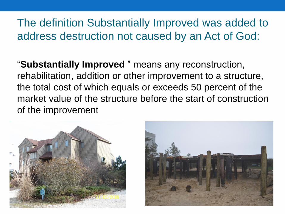
The definition Substantially Improved was added to
address destruction not caused by an Act of God:
“Substantially Improved ” means any reconstruction,
rehabilitation, addition or other improvement to a structure,
the total cost of which equals or exceeds 50 percent of the
market value of the structure before the start of construction
of the improvement

Section 3.1.1.2
The 4-step Process To “eliminate or diminish the
amount of encroachment seaward
of the Building Line” as required by
Section 6805 (d) of the Beach
Preservation Act

• All construction must begin at the setback line established for
the landward property boundary by the county and/or local
municipality in which the property is located. Porches, decks
and entrance ways are not permitted along this wall of the
building, except those which are recessed into the exterior wall
of the structure or alongside the structure. Steps may extend
into the setbacks as long as permissible by county and local
regulations, and;
Step 1 (3.1.1.2.1)
DNREC
Ocean
Street
Line
Ocean
Street
DNREC Building

Step 2 (3.1.1.2.2)
• The structure must occupy all of the area available between
the side yard setbacks, and;
Ocean
Street
DNREC
Building
Line

Step 3 (3.1.1.2.3)
• The square footage of the footprint of the structure (living area
only, not including porches or decks) shall not exceed the
average square footage that exists among adjacent structures
within the smallest subsets of lots, and;

Smallest Subset of Lots
Smallest identifiable group of lawfully subdivided,
contiguous lots that exist within a subdivision, development
or community separated by either roads or subdivision
boundaries. If there are no roads or subdivision boundaries
separating groups of lots, the smallest set of lots shall be
seven (7) lots.


Step 4 (3.1.1.2.4)
• Seaward penetration over the Building Line shall not exceed
the average encroachment that exists among adjacent
structures within the smallest subset of lots. Any decks
constructed along with the structure must meet the
requirements of Section 3.1.1.3.

Section 3.1.1.3
A deck or porch may be constructed seaward of the
Building Line, but may only extend seaward the average
distance that any lawfully constructed building or deck
extends seaward of the building line within the smallest
subset of lots.

30’
20’
15
’
15
’
10’
8’
30 + 15 + 10 + 15 + 20 + 8
= 98
98/6 = 16.3
16’

Section 3.1.1.3
Future enclosure of the cantilevered deck or porch is
prohibited and the area underneath the deck shall remain
open and free of all obstructions.

Section 3.1.1.5 If a structure is completely removed from its foundation for replacement of
said foundation, and 75% or more of the original structure remains intact, and
such a structure does not have to be located seaward of the Building Line in
order to achieve its intended purpose pursuant to Section 3.1.1.4 of these
Regulations, then such a structure shall be required to be located entirely
landward of the Building Line or shall be located as far landward as possible
on the parcel of real property in question, taking into consideration all Federal,
State and local laws, rules, regulations and zoning and building ordinance.
Under these circumstances Section 3.1.1.2 (the 4-step process) would not
apply.


Section 3.5 Effect of Beach Nourishment
3.5.1 When considering the reconstruction of buildings on lots
fronting the Ocean or Delaware Bay that are either partially or
completely seaward of the Building Line that have sustained
substantial damage through acts of God or other accidental
events, the Division will consider the effect of beach
nourishment work that has enhanced the beach and dune in
such areas. Furthermore, in any such case, where Federal or
State agencies have constructed and continue to maintain a
beach and dune that conforms to coastal engineering
standards of storm protection (as defined in these regulations)
property owners shall be permitted to rebuild in the same
footprint.
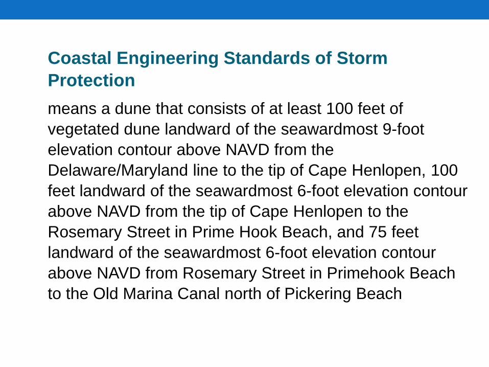
Coastal Engineering Standards of Storm
Protection
means a dune that consists of at least 100 feet of
vegetated dune landward of the seawardmost 9-foot
elevation contour above NAVD from the
Delaware/Maryland line to the tip of Cape Henlopen, 100
feet landward of the seawardmost 6-foot elevation contour
above NAVD from the tip of Cape Henlopen to the
Rosemary Street in Prime Hook Beach, and 75 feet
landward of the seawardmost 6-foot elevation contour
above NAVD from Rosemary Street in Primehook Beach
to the Old Marina Canal north of Pickering Beach

100
’
9’ N
AV
D
Build
ing L
ine
100’ l
andw
ard
of
9’ N
AV
D c
onto
ur

Section 3.1.1.6 In those cases where the mapped Building Line either transects or is landward of lots that, in turn, are landward of lots with existing habitable structures, the Building Line will not be used to modify either location or dimension of proposed buildings on the more landward lot
Ocean
Building Line

The definition of Temporary Structure was added:
“Temporary Structure ” means any not permanent non-
habitable structure that can be easily removed from the site
within a short time frame using minimal equipment and/or
man power. Examples include, but are not limited to, signs,
benches, sheds, ramps, steps or walkways

Section 3.8 Temporary Structures
3.8.1 The placement of seasonal or otherwise temporary structures
seaward of the Building Line and seaward of the dune on the dry
beach may be allowed for a period of up to a your or such lesser
period as specified with a Letter of Approval from the Department. It
must be demonstrated by the applicant that the design and
deployment of the temporary structure can be done so that the
structure can be easily removed or otherwise relocated landward of
the Building Line in a short time frame. Temporary structures must be
removed from the site during the time frame established in the letter of
approval and in the case of the threat of a coastal storm.
3.8.1.1 If the temporary structure such as, but not limited to,
tents, wedding alters, chairs, tables, are being placed on the
beach for an event that will last only 72 hours or less, the
requirement to obtain a letter of approval is waived. However, the
provisions of Section 3.7.1.5 still apply.

Section 2.4.2.1 An extension to a letter of approval or permit shall
not be granted more than three (3) times
For currently active approvals, no extension
shall be granted for a letter of approval or
permit issued prior to August 11, 2016.

Section 4.5.3.1 4.5.3.1 For the purposes of best protection of the dunes,
and to meet the needs of larger beach communities, pedestrian
dune crossovers may be constructed to certain widths. The total
number of residences that are served by each crossover will be
determined by the Division by dividing the number of possible
single family dwellings within a subdivision on non-ocean front or
bay front lots by the number of community pedestrian dune
crossovers within that subdivision.
4.5.3.1.1 Crossovers serving one or two single family
residences shall not be wider than four (4) feet
4.5.3.1.2 Community crossovers that serve anywhere
between three (3) 4.5.3.1.3 to nine (9) single family
residences shall not be wider than five (5) feet.
4.5.3.1.4 Community crossovers that serve ten (10) or more
single family residences shall not be wider than six (6) feet.
4.5.3.1.5 Crossover serving persons with special needs will
be evaluated on a case by case basis

Section 3.7 Other Prohibited Activities 3.7.1 The following activities are prohibited:
3.7.1.1 The operation of any motorized vehicle or machine on, over or across the primary dune on any State-owned or maintained beach except at those locations specified by the Department for such use (see current State Parks Rules and Regulations for additional rules); 3.7.1.2 Transportation or storage of any type of boat across or on the primary dune on any State-owned or maintained beach except at locations approved or permitted by the Department; 3.7.1.3 Pedestrian traffic on, over or across the primary dune on any State-owned or maintained beach except at those locations specified by the Department for such use; 3.7.1.4 The alteration, moving or removal of any facility, improvement or structure installed or maintained by the Department for enhancement, preservation or protection of any beach; and 3.7.1.5 The damaging, destruction or removal of any trees, shrubbery, beach grass or other vegetation growing on any State-owned or maintained beach seaward of the Building Line.
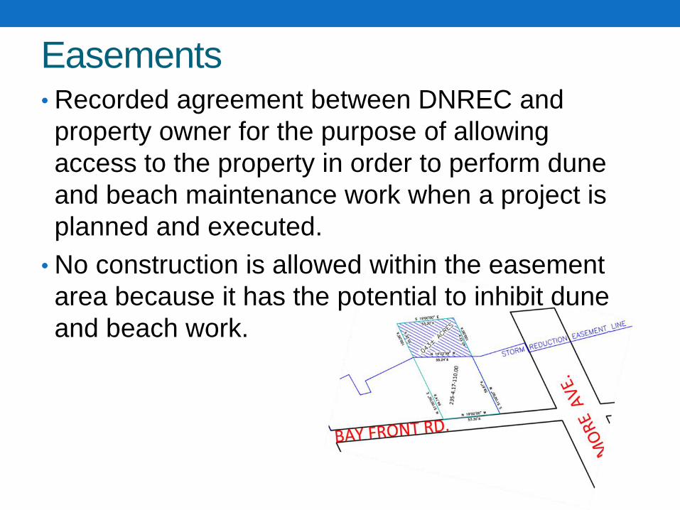
Easements • Recorded agreement between DNREC and
property owner for the purpose of allowing
access to the property in order to perform dune
and beach maintenance work when a project is
planned and executed.
• No construction is allowed within the easement
area because it has the potential to inhibit dune
and beach work.

Questions?

For more information contact:
Jennifer Luoma Michael Powell David Warga
[email protected] [email protected] [email protected]
(302) 739-9921
http://www.dnrec.delaware.gov/swc/services/
Pages/PermitsLicensesApprovals.aspx