puget sound b-ibi restoration/protection project fair site...
TRANSCRIPT

DRAFT – DO NOT CITE
Puget Sound B-IBI Restoration/Protection Project Fair Site Summaries and Restoration Strategies
King County, May 19, 2015
For Puget Sound stakeholder review only. Please do not distribute at this time. Send comments to Kate Macneale ([email protected]) and/or Jo Opdyke Wilhelm ([email protected]) by Wednesday, May 27th. Please let us know the name of the reviewer, the basin being commented on (stream name and Site ID), and any comments or feedback you have regarding the site synopsis or recommended restoration strategies. There are 54 sites/basins total and a portfolio page for each is on the following pages organized in order of WRIA (low to high), then by site id. The figure below briefly summarizes the streams in various sections. A table is also available on the Puget Sound Stream Benthos web page with the complete list of sites including site code, stream name, and WRIA. This may be a good place to start and then search for the appropriate basin by site ID in this document.
* Please note, Vashon Island is considered WRIA 15 in the map, but is listed as WRIA 9 in the pages that follow.

DRAFT – DO NOT CITE
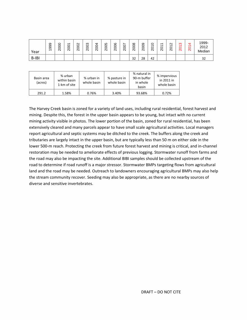
Harvey Creek in the Stillaguamish Flats subbasin – WRIA 5; Site code (site ID): CAR2B (500)

DRAFT – DO NOT CITE
Potential restoration or management actions for: Harvey Creek in the Stillaguamish Flats subbasin –
WRIA 5; Site code (site ID): CAR2B (500)
Restoration and Management Actions Likelihood action
would help restore the basin
In-stream
add wood 2
add substrate 2
enhance sinuosity 2
replace culverts 2
stabilize stream banks 2
Riparian stabilize slopes 2
plant vegetation, extend buffer 4
Agricultural BMPs
exclude livestock 4
manage waste 4
manage soil loss 2
Forest BMPs
road maintenance 4
minimize clearcutting 4
replant 3
Mining BMPs mining BMPs 2
Stormwater BMPs
flow controls 3
treatment 3
maintain storage and treatment facilities 2
street sweeping 1
Programmatic BMPs
limit pesticide use 3
outreach and education campaign 4
create incentives to follow BMPs 3
purchase and protect property 3
seed invertebrates 3
Is the basin at risk of further degradation? 4
Key for colors and numbers used in table:
not applicable unlikely possibly likely highly likely
0 1 2 3 4
Key restoration or management action(s) recommended and summary notes:
Outreach to landowners to encourage agricultural BMPs; expand buffers where applicable; forest and
stormwater BMPs
DRAFT – DO NOT CITE
Year 19
99
20
00
20
01
20
02
20
03
20
04
20
05
20
06
20
07
20
08
20
09
20
10
20
11
20
12
20
13
20
14 1999-
2012 Median
B-IBI 32 28 42 32
Basin area (acres)
% urban within basin 1-km of site
% urban in whole basin
% pasture in whole basin
% natural in 90-m buffer
in whole basin
% impervious in 2011 in
whole basin
291.2 1.58% 0.76% 3.40% 93.68% 0.72%
The Harvey Creek basin is zoned for a variety of land uses, including rural residential, forest harvest and
mining. Despite this, the forest in the upper basin appears to be young, but intact with no current
mining activity visible in photos. The lower portion of the basin, zoned for rural residential, has been
extensively cleared and many parcels appear to have small scale agricultural activities. Local managers
report agricultural and septic systems may be ditched to the creek. The buffers along the creek and
tributaries are largely intact in the upper basin, but are typically less than 50 m on either side in the
lower 500-m reach. Protecting the creek from future forest harvest and mining is critical, and in-channel
restoration may be needed to ameliorate effects of previous logging. Stormwater runoff from farms and
the road may also be impacting the site. Additional BIBI samples should be collected upstream of the
road to determine if road runoff is a major stressor. Stormwater BMPs targeting flows from agricultural
land and the road may be needed. Outreach to landowners encouraging agricultural BMPs may also help
the stream community recover. Seeding may also be appropriate, as there are no nearby sources of
diverse and sensitive invertebrates.
DRAFT – DO NOT CITE
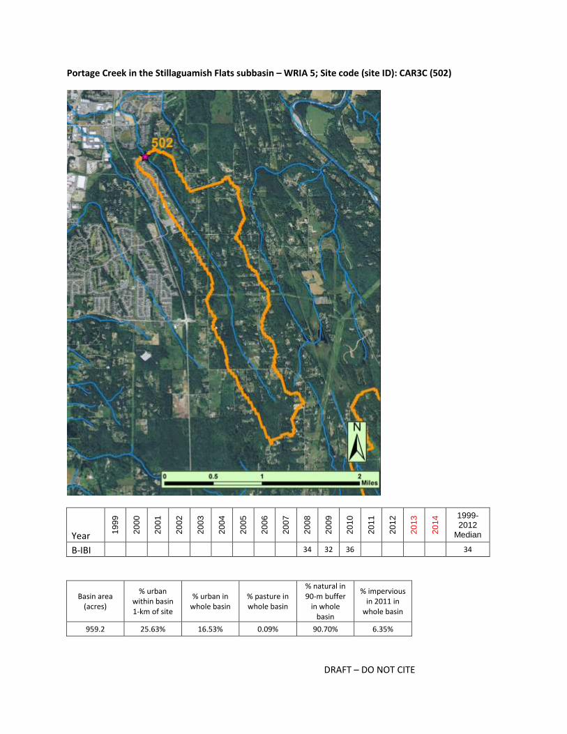
Portage Creek in the Stillaguamish Flats subbasin – WRIA 5; Site code (site ID): CAR3C (502)
Year 19
99
20
00
20
01
20
02
20
03
20
04
20
05
20
06
20
07
20
08
20
09
20
10
20
11
20
12
20
13
20
14 1999-
2012 Median
B-IBI 34 32 36 34
Basin area (acres)
% urban within basin 1-km of site
% urban in whole basin
% pasture in whole basin
% natural in 90-m buffer
in whole basin
% impervious in 2011 in
whole basin
959.2 25.63% 16.53% 0.09% 90.70% 6.35%

DRAFT – DO NOT CITE
Potential restoration or management actions for: Portage Creek in the Stillaguamish Flats subbasin –
WRIA 5; Site code (site ID): CAR3C (502)
Restoration and Management Actions Likelihood action
would help restore the basin
In-stream
add wood 2
add substrate 2
enhance sinuosity 2
replace culverts 2
stabilize stream banks 2
Riparian stabilize slopes 2
plant vegetation, extend buffer 3
Agricultural BMPs
exclude livestock 1
manage waste 1
manage soil loss 1
Forest BMPs
road maintenance 0
minimize clearcutting 0
replant 0
Mining BMPs mining BMPs 0
Stormwater BMPs
flow controls 4
treatment 4
maintain storage and treatment facilities 4
street sweeping 3
Programmatic BMPs
limit pesticide use 3
outreach and education campaign 3
create incentives to follow BMPs 3
purchase and protect property 3
seed invertebrates 3
Is the basin at risk of further degradation? 4
Key for colors and numbers used in table:
not applicable unlikely possibly likely highly likely
0 1 2 3 4
Key restoration or management action(s) recommended and summary notes:
Stormwater BMPs, outreach

DRAFT – DO NOT CITE
The Portage Creek basin is zoned primarily for rural residential except for 4.5% zoned for urban
residential located near the site and zoned urban residential. A dense development just south of the site
and in the lower 1-km basin was built in 2001; stormwater infrastructure near these homes should be
cleaned and maintained. The PSWC process analysis indicated flow processes and water quality have
been degraded , suggesting flow processes across the basin could be improved. Snohomish County staff
indicated the BIBI site is located in a low-gradient area and an established channel does not form until
farther downstream. The low gradient habitat may be naturally limiting the composition of the
invertebrate community, but it appears there are still some sensitive taxa present. For example the
Heptageniid mayfly Cinygmula has been abundant in the three years the site has been sampled, and
while it is more tolerant of slower moving water than some mayflies, it is not tolerant of fine sediment
and metals. If seeding is implemented, imported invertebrates should be from similar low-gradient
streams. If more development occurs, buffers should be maintained and stormwater BMPs should be
installed. The intrinsic potential for fish is relatively high at this site (rank of 8), and thus restoration
actions within the channel could create more complex habitat for both invertebrates and fish.

DRAFT – DO NOT CITE
Cherry Ck. - N Fork in the Cherry Creek subbasin – WRIA 7; Site code (site ID): E1078 (282)
Year 19
99
20
00
20
01
20
02
20
03
20
04
20
05
20
06
20
07
20
08
20
09
20
10
20
11
20
12
20
13
20
14 1999-
2012 Median
B-IBI 16 20 34 34 32 36 36 46 42 32 34
Basin area (acres)
% urban within basin 1-km of site
% urban in whole basin
% pasture in whole basin
% natural in 90-m buffer
in whole basin
% impervious in 2011 in
whole basin
1124.9 16.55% 5.73% 0.00% 98.08% 1.87%

DRAFT – DO NOT CITE
Potential restoration or management actions for: Cherry Ck. - N Fork in the Cherry Creek subbasin –
WRIA 7; Site code (site ID): E1078 (282)
Restoration and Management Actions Likelihood action
would help restore the basin
In-stream
add wood 2
add substrate 2
enhance sinuosity 1
replace culverts 1
stabilize stream banks 1
Riparian stabilize slopes 2
plant vegetation, extend buffer 3
Agricultural BMPs
exclude livestock 4
manage waste 0
manage soil loss 0
Forest BMPs
road maintenance 0
minimize clearcutting 4
replant 0
Mining BMPs mining BMPs 0
Stormwater BMPs
flow controls 3
treatment 3
maintain storage and treatment facilities 2
street sweeping 1
Programmatic BMPs
limit pesticide use 3
outreach and education campaign 4
create incentives to follow BMPs 4
purchase and protect property 2
seed invertebrates 2
Is the basin at risk of further degradation? 4
Key for colors and numbers used in table:
not applicable unlikely possibly likely highly likely
0 1 2 3 4
Key restoration or management action(s) recommended and summary notes:
Outreach to landowners to encourage agricultural BMPs

DRAFT – DO NOT CITE
The North Fork Cherry Creek basin is zoned as rural residential in the lower portion and resource forest
in upper portion, and development ranges in age and type. Structures range from barns, to mobile
homes to 3000+ square foot single-family residences. Some homes appear to be very old (e.g., 1916), it
is uncertain what the current status of sewer and/or septic systems may be. Photos suggest there may
also be a small resort or property with multiple units (e.g., multiple yurts and out buildings present, and
high density of cars) near a large wetland west of Soup Hole and NW of lake Margaret. In the lower
portion of the basin, many parcels have been cleared for hobby farms. The buffer is largely intact, but, in
some areas, buildings and fields are within 20 m of the channel. There may be parcel-specific issues that
could be affecting water quality (e.g., pesticide use, failing septic, livestock, abandoned cars within 20m
of channel). Forested land appears multi-aged and intact, and there are several wetlands in the upper
basin. Minimizing impacts from future forest harvest should be prioritized. The PSWC processes analysis
indicates surface storage and discharge scored "2", while other processes scored "1". Actions should
likely target landowners, and include education efforts to protect flow and water quality processes.
There is likely local and agency support for restoration actions; the WRIA group has identified Cherry
Creek as a prime restoration area and multiple projects are being implemented in reaches downstream
of the BIBI site.

DRAFT – DO NOT CITE
Cherry Ck. Trib in the Cherry Creek subbasin – WRIA 7; Site code (site ID): E1076 (283)
Year 19
99
20
00
20
01
20
02
20
03
20
04
20
05
20
06
20
07
20
08
20
09
20
10
20
11
20
12
20
13
20
14 1999-
2012 Median
B-IBI 24 36 28 36 36 42 36 30 40 36 34 38 36
Basin area (acres)
% urban within basin 1-km of site
% urban in whole basin
% pasture in whole basin
% natural in 90-m buffer
in whole basin
% impervious in 2011 in
whole basin
584.4 7.95% 7.96% 0.00% 89.49% 2.61%

DRAFT – DO NOT CITE
Potential restoration or management actions for: Cherry Ck. Trib in the Cherry Creek subbasin – WRIA
7; Site code (site ID): E1076 (283)
Restoration and Management Actions Likelihood action
would help restore the basin
In-stream
add wood 2
add substrate 2
enhance sinuosity 2
replace culverts 2
stabilize stream banks 2
Riparian stabilize slopes 2
plant vegetation, extend buffer 3
Agricultural BMPs
exclude livestock 0
manage waste 0
manage soil loss 0
Forest BMPs
road maintenance 2
minimize clearcutting 3
replant 0
Mining BMPs mining BMPs 0
Stormwater BMPs
flow controls 4
treatment 4
maintain storage and treatment facilities 2
street sweeping 1
Programmatic BMPs
limit pesticide use 4
outreach and education campaign 4
create incentives to follow BMPs 4
purchase and protect property 2
seed invertebrates 2
Is the basin at risk of further degradation? 2
Key for colors and numbers used in table:
not applicable unlikely possibly likely highly likely
0 1 2 3 4
Key restoration or management action(s) recommended and summary notes:
Stormwater BMPs that target road runoff; increasing buffer width; outreach to landowners

DRAFT – DO NOT CITE
The basin for this Cherry Creek tributary is primarily zoned as rural residential, with the rest as resource
forest. Land use in the basin is similar to site 282 (another Cherry Creek tributary), with 1 to 5+-acre
parcels with single family residences and small farms. There are several wetlands in this small basin, and
relatively little impervious surface, however the PSWC processes analysis indicated surface storage and
discharge were degraded at the basin scale (score of "2"). The creek follows Kelly Road NE, and
tributaries cross the road at several points; stormwater runoff from the road may be impacting the
creek and actions that reduce and treat road runoff may be appropriate. The PSWC prioritized the basin
for stormwater BMPs, and there may be local support for restorations actions, because Chinook salmon
use the mainstem of Cherry Creek.
DRAFT – DO NOT CITE
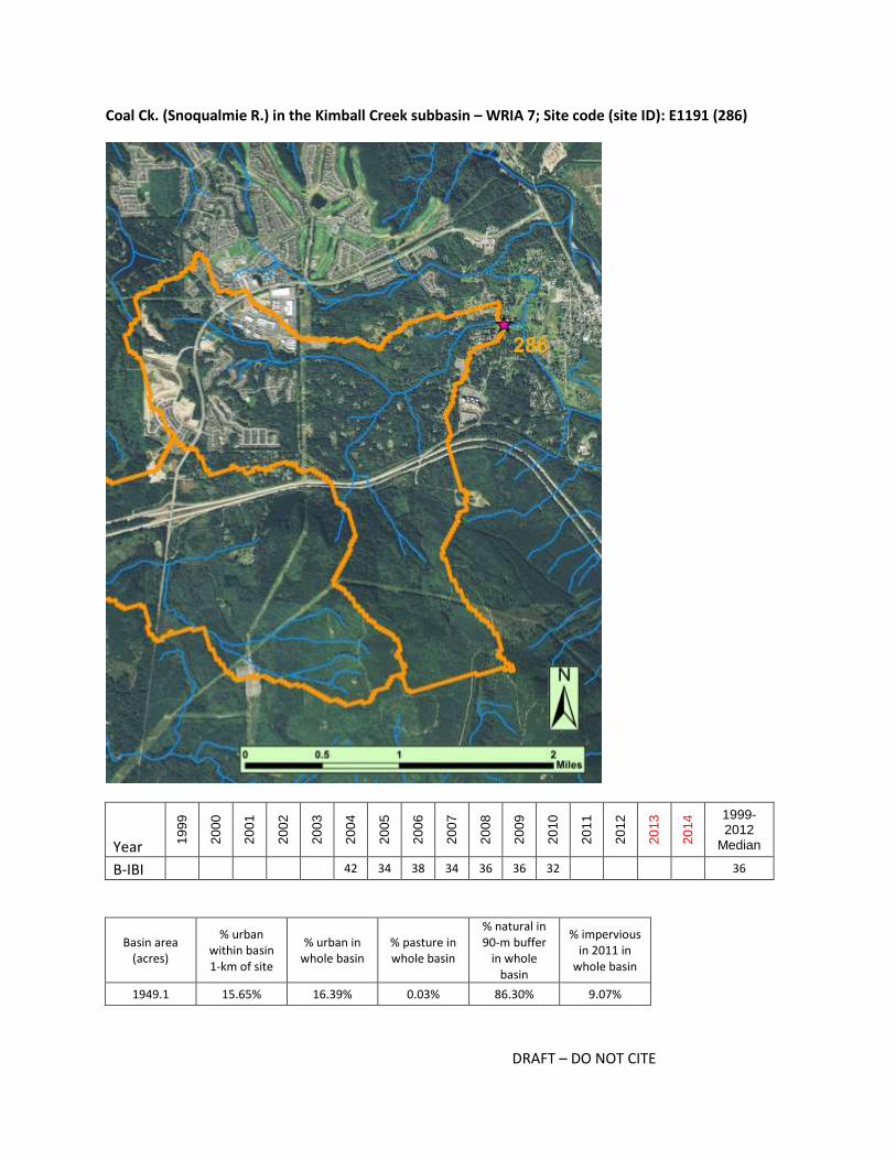
Coal Ck. (Snoqualmie R.) in the Kimball Creek subbasin – WRIA 7; Site code (site ID): E1191 (286)
Year 19
99
20
00
20
01
20
02
20
03
20
04
20
05
20
06
20
07
20
08
20
09
20
10
20
11
20
12
20
13
20
14 1999-
2012 Median
B-IBI 42 34 38 34 36 36 32 36
Basin area (acres)
% urban within basin 1-km of site
% urban in whole basin
% pasture in whole basin
% natural in 90-m buffer
in whole basin
% impervious in 2011 in
whole basin
1949.1 15.65% 16.39% 0.03% 86.30% 9.07%
DRAFT – DO NOT CITE
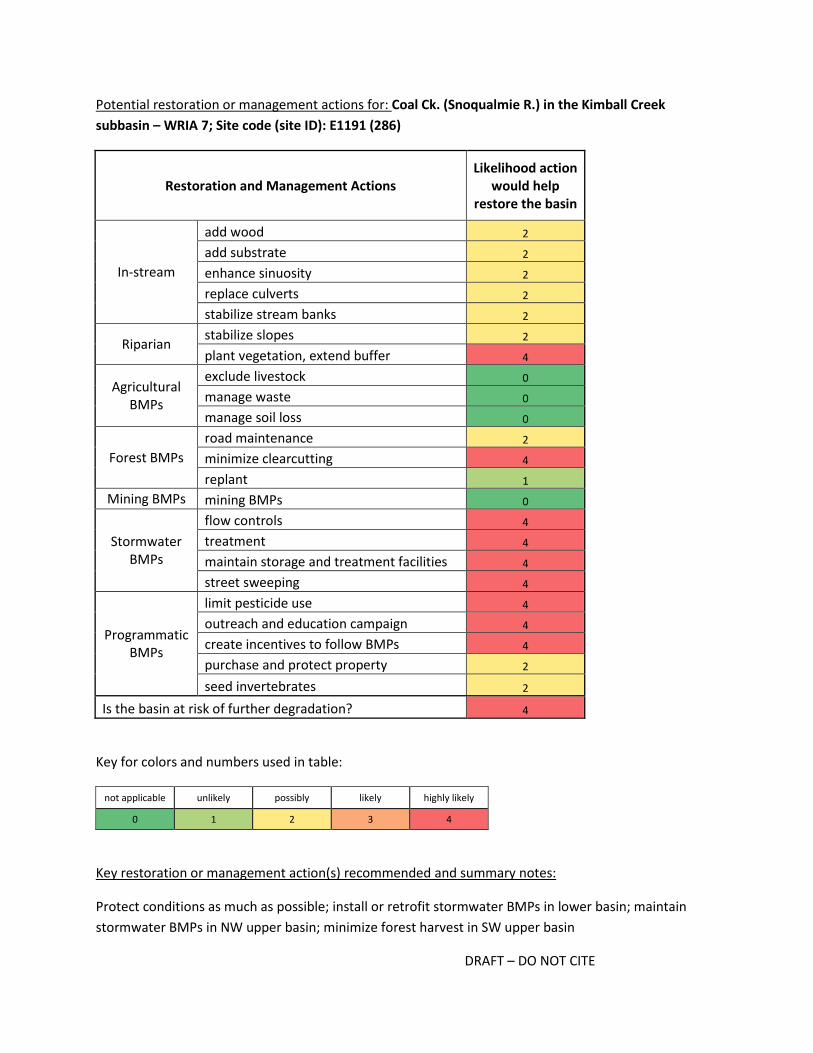
Potential restoration or management actions for: Coal Ck. (Snoqualmie R.) in the Kimball Creek
subbasin – WRIA 7; Site code (site ID): E1191 (286)
Restoration and Management Actions Likelihood action
would help restore the basin
In-stream
add wood 2
add substrate 2
enhance sinuosity 2
replace culverts 2
stabilize stream banks 2
Riparian stabilize slopes 2
plant vegetation, extend buffer 4
Agricultural BMPs
exclude livestock 0
manage waste 0
manage soil loss 0
Forest BMPs
road maintenance 2
minimize clearcutting 4
replant 1
Mining BMPs mining BMPs 0
Stormwater BMPs
flow controls 4
treatment 4
maintain storage and treatment facilities 4
street sweeping 4
Programmatic BMPs
limit pesticide use 4
outreach and education campaign 4
create incentives to follow BMPs 4
purchase and protect property 2
seed invertebrates 2
Is the basin at risk of further degradation? 4
Key for colors and numbers used in table:
not applicable unlikely possibly likely highly likely
0 1 2 3 4
Key restoration or management action(s) recommended and summary notes:
Protect conditions as much as possible; install or retrofit stormwater BMPs in lower basin; maintain
stormwater BMPs in NW upper basin; minimize forest harvest in SW upper basin

DRAFT – DO NOT CITE
There are multiple potential stressors in the Kimball Creek basin, including runoff from major roads and
highways (I-90, Snoqualmie Parkway and SE North Bend Way), runoff from older developments that
likely lack stormwater BMPs and runoff from new commercial and residential developments that are
extremely dense. The lower portion of basin is zoned urban character residential; most of the homes
were built in the 1980s or earlier, and it is unclear if current development is as dense as the zoning
would allow. There would likely be opportunities to install or retrofit older stormwater systems in this
lower basin. Protecting and expanding buffers is recommended, especially if new housing will be built in
the lower basin. Most of the 1-km basin nearest to the site and much of the upper NW basin is within
the Urban Growth Area, and the increase in impervious surface in the last decade has been dramatic
(>6%). Photos indicate extensive forest clearing had begun in the NW portion of the basin by 2006, and
2015 photos (Google maps) indicate housing developments are not yet complete. Photos also suggest
multiple stormwater ponds have been built in the new developments. Photos reveal logging in the SW
portion of the basin (S of I-90), and while the age of the new growth is uncertain, the crowns appear
small in the 2013 photos. Water flow processes (including surface storage and recharge) and water
quality processes received a score of "2", supporting the observations that road runoff and impacts on
flow dynamics are likely affecting much of the basin. The SW fork S of I-90 may be a source of diverse
invertebrates, but this should be verified.

DRAFT – DO NOT CITE
Harris Creek in the Harris Creek subbasin – WRIA 7; Site code (site ID): E1105 (303)
Year 19
99
20
00
20
01
20
02
20
03
20
04
20
05
20
06
20
07
20
08
20
09
20
10
20
11
20
12
20
13
20
14 1999-
2012 Median
B-IBI 24 36 38 26 26 32 28 30 32 32 31
Basin area (acres)
% urban within basin 1-km of site
% urban in whole basin
% pasture in whole basin
% natural in 90-m buffer
in whole basin
% impervious in 2011 in
whole basin
770.0 2.40% 1.53% 0.00% 98.59% 0.99%
DRAFT – DO NOT CITE
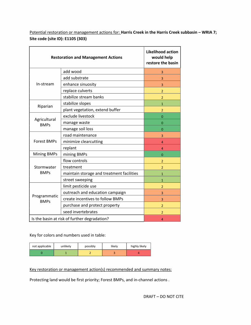
Potential restoration or management actions for: Harris Creek in the Harris Creek subbasin – WRIA 7;
Site code (site ID): E1105 (303)
Restoration and Management Actions Likelihood action
would help restore the basin
In-stream
add wood 3
add substrate 3
enhance sinuosity 3
replace culverts 2
stabilize stream banks 2
Riparian stabilize slopes 1
plant vegetation, extend buffer 2
Agricultural BMPs
exclude livestock 0
manage waste 0
manage soil loss 0
Forest BMPs
road maintenance 3
minimize clearcutting 4
replant 4
Mining BMPs mining BMPs 0
Stormwater BMPs
flow controls 2
treatment 2
maintain storage and treatment facilities 1
street sweeping 1
Programmatic BMPs
limit pesticide use 2
outreach and education campaign 3
create incentives to follow BMPs 3
purchase and protect property 2
seed invertebrates 2
Is the basin at risk of further degradation? 4
Key for colors and numbers used in table:
not applicable unlikely possibly likely highly likely
0 1 2 3 4
Key restoration or management action(s) recommended and summary notes:
Protecting land would be first priority; Forest BMPs, and in-channel actions .

DRAFT – DO NOT CITE
The Harris Creek basin is zoned primarily as forest resource, and the 2013 photos show recent and
extensive clearcutting. This clearing likely occurred after the last BIBI samples were collected in 2010,
and therefore conditions and scores may have worsened since then. Collecting current BIBI samples will
be important for confirming or establishing a new baseline. Logging likely affected basin conditions prior
to 2010, as previous forest clearing is evident in 2006 photos. The stream follows Stossel Creek Way for
about 400 m upstream of the BIBI site, and therefore runoff and local habitat may be affected by the
road. The portion of the basin zoned for rural residential (26%) could be further developed (many plots
are 20+ acres). Wetlands are extensive throughout the basin, and the PSWC analysis indicate most flow
and water quality processes are minimally degraded at the basin scale. Mayfly taxa richness has been
consistently low, and surprisingly Baetis have almost never been found. Additionally, Odonata and
Megaloptera are occasionally present. These invertebrate community characteristics indicate the stream
gradient is low and water flows are stable; natural conditions may limit the richness of some taxa better
adapted to high energy systems. This site ranked high as a site with intrinsic potential for fish, however
Kollin Higgins of King County reports there is a fish passage barrier downstream.
DRAFT – DO NOT CITE
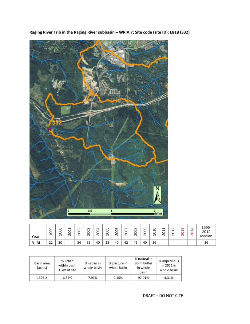
Raging River Trib in the Raging River subbasin – WRIA 7; Site code (site ID): E818 (332)
Year 19
99
20
00
20
01
20
02
20
03
20
04
20
05
20
06
20
07
20
08
20
09
20
10
20
11
20
12
20
13
20
14 1999-
2012 Median
B-IBI 22 30 34 32 40 28 40 42 42 40 36 36
Basin area (acres)
% urban within basin 1-km of site
% urban in whole basin
% pasture in whole basin
% natural in 90-m buffer
in whole basin
% impervious in 2011 in
whole basin
1595.2 6.35% 7.93% 0.15% 97.01% 4.31%

DRAFT – DO NOT CITE
Potential restoration or management actions for: Raging River Trib in the Raging River subbasin – WRIA
7; Site code (site ID): E818 (332)
Restoration and Management Actions Likelihood action
would help restore the basin
In-stream
add wood 2
add substrate 2
enhance sinuosity 2
replace culverts 2
stabilize stream banks 2
Riparian stabilize slopes 2
plant vegetation, extend buffer 2
Agricultural BMPs
exclude livestock 0
manage waste 0
manage soil loss 0
Forest BMPs
road maintenance 2
minimize clearcutting 4
replant 3
Mining BMPs mining BMPs 0
Stormwater BMPs
flow controls 4
treatment 4
maintain storage and treatment facilities 4
street sweeping 1
Programmatic BMPs
limit pesticide use 3
outreach and education campaign 4
create incentives to follow BMPs 3
purchase and protect property 2
seed invertebrates 2
Is the basin at risk of further degradation? 4
Key for colors and numbers used in table:
not applicable unlikely possibly likely highly likely
0 1 2 3 4
Key restoration or management action(s) recommended and summary notes:
Stormwater BMPs, in older and new developments; Forest BMPs, outreach

DRAFT – DO NOT CITE
The basin of this Raging River tributary has likely been affected by a variety of stressors. Stormwater
runoff from I-90 and Highway 18 presumably drains to this basin, and there has been extensive forest
harvest in the past. The basin is zoned for rural residential (57%) and forest resource (41%), with the
most recent clearing occurring between 2006 and 2013. A ~50-acre clearcut in the lower basin (most of
which is within 1 km of site) appears to have been cleared for a housing development (Zillow indicated
Pulte Homes will be developing the area, but this could not be confirmed). Other lots in the lower 1-km
basin are for sale with notes about subdividing plots, and most of the area zoned for rural residential
south of the stream has not yet been developed. Presumably new development will include stormwater
BMPs. Other homes in the lower basin are older and have septic systems, indicating older developments
may also benefit from stormwater BMPs. Given the creek is a tributary of the Raging River and supports
steelhead, coho and Chinook, every effort should be made to maintain a wide buffer to help maintain
low water temperatures.

DRAFT – DO NOT CITE
Brockway Creek in the Kimball Creek subbasin – WRIA 7; Site code (site ID): E2153 (342)
Year 19
99
20
00
20
01
20
02
20
03
20
04
20
05
20
06
20
07
20
08
20
09
20
10
20
11
20
12
20
13
20
14 1999-
2012 Median
B-IBI 14 28 30 28 38 30 22 46 38 34 38 30
Basin area (acres)
% urban within basin 1-km of site
% urban in whole basin
% pasture in whole basin
% natural in 90-m buffer
in whole basin
% impervious in 2011 in
whole basin
1171.2 0.00% 0.27% 0.04% 99.94% 0.35%
DRAFT – DO NOT CITE
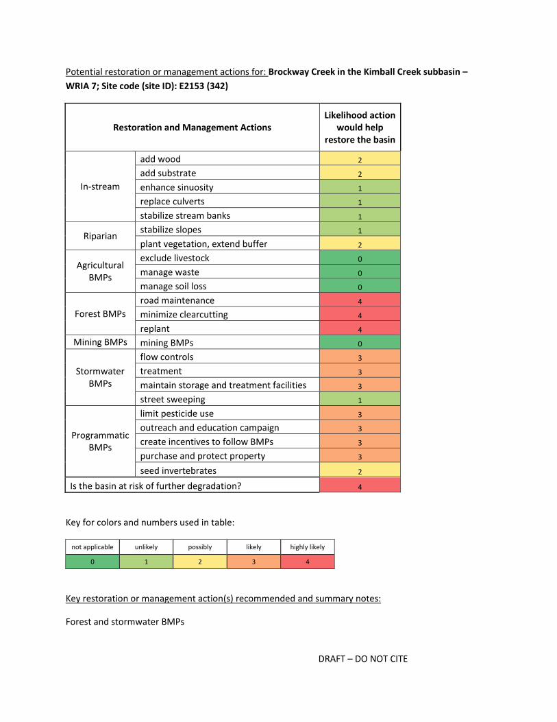
Potential restoration or management actions for: Brockway Creek in the Kimball Creek subbasin –
WRIA 7; Site code (site ID): E2153 (342)
Restoration and Management Actions Likelihood action
would help restore the basin
In-stream
add wood 2
add substrate 2
enhance sinuosity 1
replace culverts 1
stabilize stream banks 1
Riparian stabilize slopes 1
plant vegetation, extend buffer 2
Agricultural BMPs
exclude livestock 0
manage waste 0
manage soil loss 0
Forest BMPs
road maintenance 4
minimize clearcutting 4
replant 4
Mining BMPs mining BMPs 0
Stormwater BMPs
flow controls 3
treatment 3
maintain storage and treatment facilities 3
street sweeping 1
Programmatic BMPs
limit pesticide use 3
outreach and education campaign 3
create incentives to follow BMPs 3
purchase and protect property 3
seed invertebrates 2
Is the basin at risk of further degradation? 4
Key for colors and numbers used in table:
not applicable unlikely possibly likely highly likely
0 1 2 3 4
Key restoration or management action(s) recommended and summary notes:
Forest and stormwater BMPs

DRAFT – DO NOT CITE
The lower portion of the Brockway Creek basin is zoned as rural residential and the upper portion is
zoned for forest harvest and is owned by Hancock. The majority of the forest harvest land to the west of
the creek and in the upper basin was recently cleared (possibly 2012 based on the 2013 photos). The
last invertebrate sample was collected in 2010 and EPT richness was relatively high at 23 taxa. The
conditions at the site may have deteriorated since the most recent clearcuts. In the lower basin,
development on 1-12 acre parcels is likely to continue on a parcel by parcel basis. Zillow lists several
recently sold, undeveloped lots, as well as lots with older (1980s) and newer (1990s-2000s) homes.
Some homes are as close as 50 m from the stream, and homes appear to be on septic systems. There
are no known residential or commercial stormwater facilities within the basin, but they would likely be
beneficial as building continues. The basin may benefit from the knotweed control that is taking place
along the upper Snoqualmie, though it is unclear whether those actions are within the Brockway Creek
basin itself. If the upper basin is not a source of diverse invertebrates, seeding may be an appropriate
action (if remaining forest is not harvested and if additional actions are taken). The basin is located
above Snoqualmie Falls, and thus the creek is not accessible to anadromous fish.

DRAFT – DO NOT CITE
Snoqualmie R. - S Fork Trib in the S Fork Snoqualmie subbasin – WRIA 7; Site code (site ID): E1031
(346)
Year 19
99
20
00
20
01
20
02
20
03
20
04
20
05
20
06
20
07
20
08
20
09
20
10
20
11
20
12
20
13
20
14 1999-
2012 Median
B-IBI 14 24 30 30 34 30 22 30 32 28 34 24 30
Basin area (acres)
% urban within basin 1-km of site
% urban in whole basin
% pasture in whole basin
% natural in 90-m buffer
in whole basin
% impervious in 2011 in
whole basin
826.3 3.55% 8.10% 0.05% 94.33% 4.19%

DRAFT – DO NOT CITE
Potential restoration or management actions for: Snoqualmie R. - S Fork Trib in the S Fork Snoqualmie
subbasin – WRIA 7; Site code (site ID): E1031 (346)
Restoration and Management Actions Likelihood action
would help restore the basin
In-stream
add wood 2
add substrate 2
enhance sinuosity 2
replace culverts 2
stabilize stream banks 2
Riparian stabilize slopes 2
plant vegetation, extend buffer 2
Agricultural BMPs
exclude livestock 0
manage waste 0
manage soil loss 0
Forest BMPs
road maintenance 0
minimize clearcutting 0
replant 0
Mining BMPs mining BMPs 0
Stormwater BMPs
flow controls 4
treatment 4
maintain storage and treatment facilities 4
street sweeping 2
Programmatic BMPs
limit pesticide use 3
outreach and education campaign 4
create incentives to follow BMPs 3
purchase and protect property 2
seed invertebrates 3
Is the basin at risk of further degradation? 4
Key for colors and numbers used in table:
not applicable unlikely possibly likely highly likely
0 1 2 3 4
Key restoration or management action(s) recommended and summary notes:
Stormwater BMPs, outreach

DRAFT – DO NOT CITE
This Snoqualmie River tributary is within a basin zoned almost entirely for rural residential development.
Most homes appear to have been built between 1970 and 2010 on lots <1 to 20+ acres. Currently
installed stormwater BMPs should be maintained and additional stormwater BMPs may be helpful in
areas developed before the current regulations were established. The riparian buffer appears to be
intact for much of the creek's length, but on-site surveys are needed to assess in-channel habitat.
Outreach to landowners including information about land and septic maintenance may be worthwhile.
Seeding may be appropriate once additional stormwater BMPs are implemented.

DRAFT – DO NOT CITE
Boxley Creek Trib in the South Fork Snoqualmie subbasin – WRIA 7; Site code (site ID): E1045 (347)
Year 19
99
20
00
20
01
20
02
20
03
20
04
20
05
20
06
20
07
20
08
20
09
20
10
20
11
20
12
20
13
20
14 1999-
2012 Median
B-IBI 22 28 36 36 40 32 36 46 38 46 32 36
Basin area (acres)
% urban within basin 1-km of site
% urban in whole basin
% pasture in whole basin
% natural in 90-m buffer
in whole basin
% impervious in 2011 in
whole basin
398.3 0.00% 0.00% 0.00% 100.00% 0.01%
DRAFT – DO NOT CITE
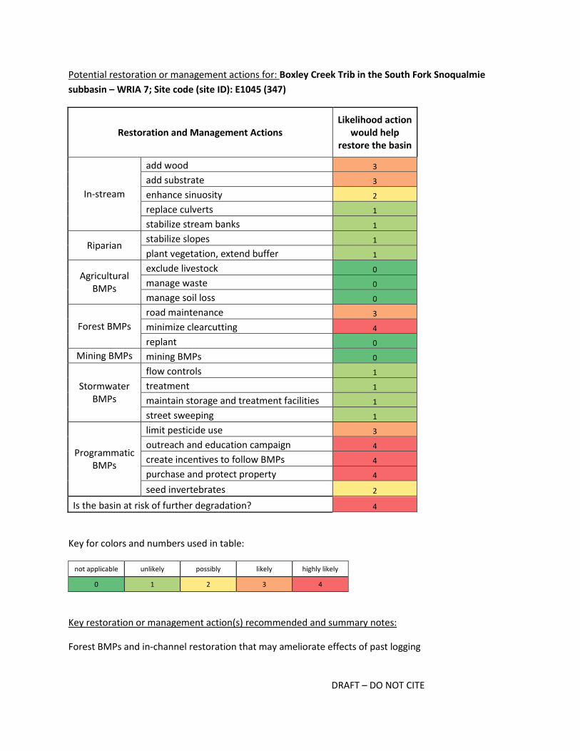
Potential restoration or management actions for: Boxley Creek Trib in the South Fork Snoqualmie
subbasin – WRIA 7; Site code (site ID): E1045 (347)
Restoration and Management Actions Likelihood action
would help restore the basin
In-stream
add wood 3
add substrate 3
enhance sinuosity 2
replace culverts 1
stabilize stream banks 1
Riparian stabilize slopes 1
plant vegetation, extend buffer 1
Agricultural BMPs
exclude livestock 0
manage waste 0
manage soil loss 0
Forest BMPs
road maintenance 3
minimize clearcutting 4
replant 0
Mining BMPs mining BMPs 0
Stormwater BMPs
flow controls 1
treatment 1
maintain storage and treatment facilities 1
street sweeping 1
Programmatic BMPs
limit pesticide use 3
outreach and education campaign 4
create incentives to follow BMPs 4
purchase and protect property 4
seed invertebrates 2
Is the basin at risk of further degradation? 4
Key for colors and numbers used in table:
not applicable unlikely possibly likely highly likely
0 1 2 3 4
Key restoration or management action(s) recommended and summary notes:
Forest BMPs and in-channel restoration that may ameliorate effects of past logging

DRAFT – DO NOT CITE
The majority of the basin for this tributary of Boxley Creek, including the entire upper watershed, is
zoned as forest resource. However, the upper watershed is also part of Iron Horse State Park, and the
Iron Horse Trail cuts across the basin. Photos from 2006 and 2013 indicate forest clearing occurred in
the past (in an area included in the park), though it is unclear from the zoning and park designation
whether additional land clearing is likely. In the lower reach, there are relatively few parcels and they
appear to range from less than 1 acre to over 10 acres. Homes were built primarily in the 1980s and
1990s, and all appear to be on septic systems with wells. Outreach to landowners in the basin may be
helpful. If the upper basin is protected as park, and landowners were receptive, bug seeding may be
appropriate.
DRAFT – DO NOT CITE
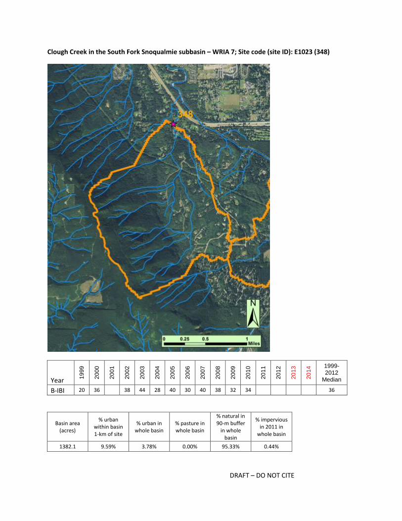
Clough Creek in the South Fork Snoqualmie subbasin – WRIA 7; Site code (site ID): E1023 (348)
Year 19
99
20
00
20
01
20
02
20
03
20
04
20
05
20
06
20
07
20
08
20
09
20
10
20
11
20
12
20
13
20
14 1999-
2012 Median
B-IBI 20 36 38 44 28 40 30 40 38 32 34 36
Basin area (acres)
% urban within basin 1-km of site
% urban in whole basin
% pasture in whole basin
% natural in 90-m buffer
in whole basin
% impervious in 2011 in
whole basin
1382.1 9.59% 3.78% 0.00% 95.33% 0.44%

DRAFT – DO NOT CITE
Potential restoration or management actions for: Clough Creek in the South Fork Snoqualmie subbasin
– WRIA 7; Site code (site ID): E1023 (348)
Restoration and Management Actions Likelihood action
would help restore the basin
In-stream
add wood 3
add substrate 3
enhance sinuosity 3
replace culverts 3
stabilize stream banks 3
Riparian stabilize slopes 2
plant vegetation, extend buffer 2
Agricultural BMPs
exclude livestock 0
manage waste 0
manage soil loss 0
Forest BMPs
road maintenance 2
minimize clearcutting 4
replant 2
Mining BMPs mining BMPs 0
Stormwater BMPs
flow controls 3
treatment 3
maintain storage and treatment facilities 2
street sweeping 1
Programmatic BMPs
limit pesticide use 2
outreach and education campaign 3
create incentives to follow BMPs 3
purchase and protect property 3
seed invertebrates 2
Is the basin at risk of further degradation? 3
Key for colors and numbers used in table:
not applicable unlikely possibly likely highly likely
0 1 2 3 4
Key restoration or management action(s) recommended and summary notes:
Proceed with restoration actions for mitigating dredging; consider targeting monitoring, and possibly
additional in-stream restoration actions, stormwater BMPs and forest BMPs

DRAFT – DO NOT CITE
Restoration plan is in place to mitigate for dredging that has occurred in the Clough Creek basin. This
may provide an opportunity for measuring restoration effectiveness. In addition, stormwater and forest
BMPs should be considered given the zoning. Parcels in the lower basin range from <1 to 10 acres, and
all appear to be on septic systems. There may be opportunities for education and outreach. Upstream
sites should be sampled to assess whether there is a connected source of diverse invertebrates. If there
is not a good upstream source, seeding may be appropriate.
DRAFT – DO NOT CITE
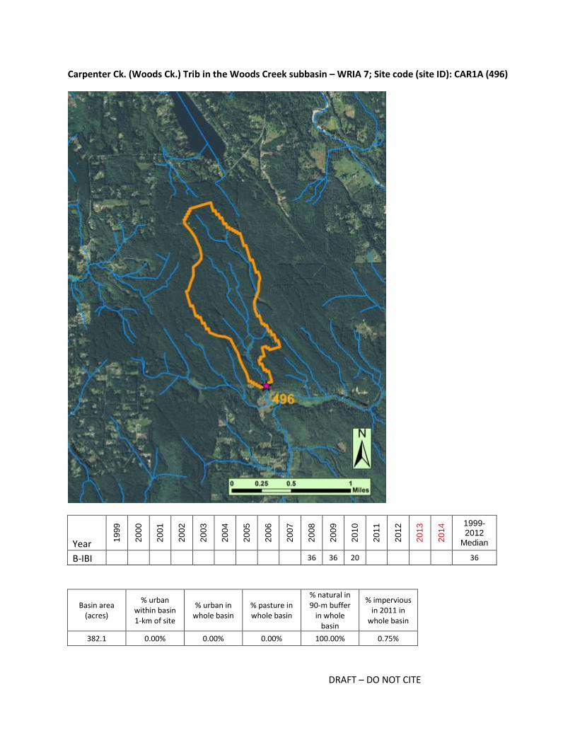
Carpenter Ck. (Woods Ck.) Trib in the Woods Creek subbasin – WRIA 7; Site code (site ID): CAR1A (496)
Year 19
99
20
00
20
01
20
02
20
03
20
04
20
05
20
06
20
07
20
08
20
09
20
10
20
11
20
12
20
13
20
14 1999-
2012 Median
B-IBI 36 36 20 36
Basin area (acres)
% urban within basin 1-km of site
% urban in whole basin
% pasture in whole basin
% natural in 90-m buffer
in whole basin
% impervious in 2011 in
whole basin
382.1 0.00% 0.00% 0.00% 100.00% 0.75%

DRAFT – DO NOT CITE
Potential restoration or management actions for: Carpenter Ck. (Woods Ck.) Trib in the Woods Creek
subbasin – WRIA 7; Site code (site ID): CAR1A (496)
Restoration and Management Actions Likelihood action
would help restore the basin
In-stream
add wood 2
add substrate 2
enhance sinuosity 2
replace culverts 2
stabilize stream banks 2
Riparian stabilize slopes 1
plant vegetation, extend buffer 1
Agricultural BMPs
exclude livestock 0
manage waste 0
manage soil loss 0
Forest BMPs
road maintenance 0
minimize clearcutting 0
replant 0
Mining BMPs mining BMPs 0
Stormwater BMPs
flow controls 0
treatment 0
maintain storage and treatment facilities 0
street sweeping 0
Programmatic BMPs
limit pesticide use 2
outreach and education campaign 0
create incentives to follow BMPs 2
purchase and protect property 2
seed invertebrates 4
Is the basin at risk of further degradation? 4
Key for colors and numbers used in table:
not applicable unlikely possibly likely highly likely
0 1 2 3 4
Key restoration or management action(s) recommended and summary notes:
Seeding
DRAFT – DO NOT CITE
The basin of the Carpenter Creek tributary (in the Woods Creek sub-basin) is zoned exclusively for rural
residential and yet there has been very little if any development in the basin. The basin appears to be
largely WADNR land, though this needs to be confirmed. There are some odd patterns in the 2013
photos - for example radiating lines from one of the dirt roads in the lower part of the basin. The BIBI
scores are based on 3 sq ft samples, and in the three years of sampling, there have never been 500 or
more organisms per sample. The most recent sample in 2010 was the least dense, with only 152
organisms per 3 sq ft sample. More area may need to be sampled to get a sufficient number of
invertebrates, but there may also be natural limitations at the site. There is a large wetland
approximately 500 m upstream of the BIBI site, and this may limit the diversity of invertebrates. An on-
site evaluation would be needed to determine what restoration would be needed, but until then, it is
unclear what actions would be appropriate for improving BIBI scores. Seeding may be an appropriate
action.

DRAFT – DO NOT CITE
Little Pilchuck Ck. (Snohomish) in the Lower Pilchuck R. (Snohomish) subbasin – WRIA 7; Site code
(site ID): CAR3A (501)
Year 19
99
20
00
20
01
20
02
20
03
20
04
20
05
20
06
20
07
20
08
20
09
20
10
20
11
20
12
20
13
20
14 1999-
2012 Median
B-IBI 32 30 28 30
Basin area (acres)
% urban within basin 1-km of site
% urban in whole basin
% pasture in whole basin
% natural in 90-m buffer
in whole basin
% impervious in 2011 in
whole basin
1406.5 11.41% 11.89% 0.52% 93.43% 3.92%

DRAFT – DO NOT CITE
Potential restoration or management actions for: Little Pilchuck Ck. (Snohomish) in the Lower Pilchuck
R. (Snohomish) subbasin – WRIA 7; Site code (site ID): CAR3A (501)
Restoration and Management Actions Likelihood action
would help restore the basin
In-stream
add wood 2
add substrate 2
enhance sinuosity 2
replace culverts 2
stabilize stream banks 2
Riparian stabilize slopes 2
plant vegetation, extend buffer 3
Agricultural BMPs
exclude livestock 0
manage waste 0
manage soil loss 0
Forest BMPs
road maintenance 0
minimize clearcutting 0
replant 0
Mining BMPs mining BMPs 0
Stormwater BMPs
flow controls 4
treatment 4
maintain storage and treatment facilities 4
street sweeping 1
Programmatic BMPs
limit pesticide use 2
outreach and education campaign 3
create incentives to follow BMPs 3
purchase and protect property 3
seed invertebrates 3
Is the basin at risk of further degradation? 4
Key for colors and numbers used in table:
not applicable unlikely possibly likely highly likely
0 1 2 3 4
Key restoration or management action(s) recommended and summary notes:
Stormwater BMPs, outreach, widen buffer where possible

DRAFT – DO NOT CITE
The Little Pilchuck Creek basin is zoned entirely for rural residential, but it has not been completely
developed. More than half of the lower 1-km portion of the basin has been slated for development, but
it is uncertain if and when that development will occur. Outreach confirmed that old detention ponds
are still in place, but it is unclear whether specific plans were still permitted. There are also multiple
sections of forest in the upper basin that have been cleared within the last several years, and new roads
have been built. There are some large wetlands within 1-km upstream of the site and within the cleared
powerline right-of-way; stream community may be limited by low gradient, though productivity is likely
high. It will not be possible to revegetate the riparian buffer under the powerlines, but widening the
buffer elsewhere may help cool the stream and ensure restoration actions will also benefit fish.
Protecting buffers and current in-channel habitat will be especially important if new developments
proceeds. Installing stormwater BMPs will also be important. Treating stormwater runoff from the
private airport with stormwater BMPs is also recommended. Seeding may be appropriate, as there no
known nearby or connected sources of diverse taxa.
DRAFT – DO NOT CITE
Cherry Ck. in the Cherry Creek subbasin – WRIA 7; Site code (site ID): 05B (520)
Year 19
99
20
00
20
01
20
02
20
03
20
04
20
05
20
06
20
07
20
08
20
09
20
10
20
11
20
12
20
13
20
14 1999-
2012 Median
B-IBI 40 28 46 36 36 36
Basin area (acres)
% urban within basin 1-km of site
% urban in whole basin
% pasture in whole basin
% natural in 90-m buffer
in whole basin
% impervious in 2011 in
whole basin
860.1 3.35% 6.57% 0.16% 98.12% 2.13%
DRAFT – DO NOT CITE
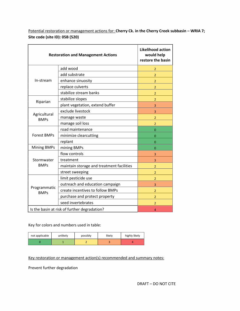
Potential restoration or management actions for: Cherry Ck. in the Cherry Creek subbasin – WRIA 7;
Site code (site ID): 05B (520)
Restoration and Management Actions Likelihood action
would help restore the basin
In-stream
add wood 2
add substrate 2
enhance sinuosity 2
replace culverts 2
stabilize stream banks 2
Riparian stabilize slopes 2
plant vegetation, extend buffer 3
Agricultural BMPs
exclude livestock 3
manage waste 2
manage soil loss 2
Forest BMPs
road maintenance 0
minimize clearcutting 0
replant 0
Mining BMPs mining BMPs 0
Stormwater BMPs
flow controls 3
treatment 3
maintain storage and treatment facilities 2
street sweeping 2
Programmatic BMPs
limit pesticide use 2
outreach and education campaign 3
create incentives to follow BMPs 2
purchase and protect property 2
seed invertebrates 2
Is the basin at risk of further degradation? 4
Key for colors and numbers used in table:
not applicable unlikely possibly likely highly likely
0 1 2 3 4
Key restoration or management action(s) recommended and summary notes:
Prevent further degradation
DRAFT – DO NOT CITE
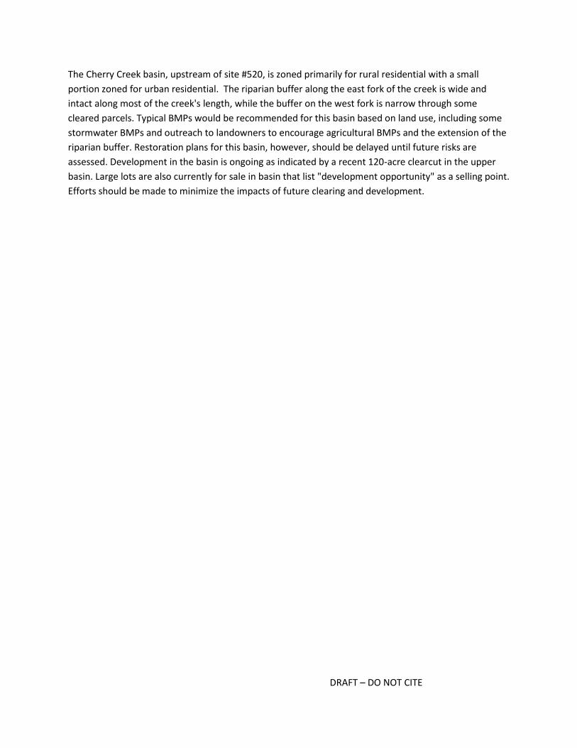
The Cherry Creek basin, upstream of site #520, is zoned primarily for rural residential with a small
portion zoned for urban residential. The riparian buffer along the east fork of the creek is wide and
intact along most of the creek's length, while the buffer on the west fork is narrow through some
cleared parcels. Typical BMPs would be recommended for this basin based on land use, including some
stormwater BMPs and outreach to landowners to encourage agricultural BMPs and the extension of the
riparian buffer. Restoration plans for this basin, however, should be delayed until future risks are
assessed. Development in the basin is ongoing as indicated by a recent 120-acre clearcut in the upper
basin. Large lots are also currently for sale in basin that list "development opportunity" as a selling point.
Efforts should be made to minimize the impacts of future clearing and development.

DRAFT – DO NOT CITE
Coon Creek/Swartz Lake Ck. in the Upper Pilchuck R. (Snohomish) subbasin – WRIA 7; Site code (site
ID): 7-981 (959)
Year 19
99
20
00
20
01
20
02
20
03
20
04
20
05
20
06
20
07
20
08
20
09
20
10
20
11
20
12
20
13
20
14 1999-
2012 Median
B-IBI 32 34 20 32
Basin area (acres)
% urban within basin 1-km of site
% urban in whole basin
% pasture in whole basin
% natural in 90-m buffer
in whole basin
% impervious in 2011 in
whole basin
1845.2 1.75% 3.58% 0.51% 100.00% 0.33%

DRAFT – DO NOT CITE
Potential restoration or management actions for: Coon Creek/Swartz Lake Ck. in the Upper Pilchuck R.
(Snohomish) subbasin – WRIA 7; Site code (site ID): 7-981 (959)
Restoration and Management Actions Likelihood action
would help restore the basin
In-stream
add wood 2
add substrate 2
enhance sinuosity 2
replace culverts 2
stabilize stream banks 2
Riparian stabilize slopes 2
plant vegetation, extend buffer 2
Agricultural BMPs
exclude livestock 1
manage waste 1
manage soil loss 1
Forest BMPs
road maintenance 0
minimize clearcutting 0
replant 0
Mining BMPs mining BMPs 4
Stormwater BMPs
flow controls 4
treatment 4
maintain storage and treatment facilities 4
street sweeping 1
Programmatic BMPs
limit pesticide use 2
outreach and education campaign 2
create incentives to follow BMPs 2
purchase and protect property 2
seed invertebrates 3
Is the basin at risk of further degradation? 4
Key for colors and numbers used in table:
not applicable unlikely possibly likely highly likely
0 1 2 3 4
Key restoration or management action(s) recommended and summary notes:
Mining and stormwater BMPs, then possibly seeding

DRAFT – DO NOT CITE
The Coon Creek basin is zoned primarily for rural residential with 5% zoned for mining. There is a large
mine in the basin, and local managers report mining activity was expanded in 2010, which may account
for the drop in the 2010 BIBI score. Although much of rural residential portion of the basin has not been
developed, managers recommend stormwater BMPs be installed to treat runoff from the current homes
and roads. There may also be natural limitations, with a large wetland starting about 150 m upstream of
the site and extending another 500 m upstream. Temperatures may be elevated, and flows may be slow.
The wetland may also be a natural barrier to possible colonists drifting from upstream reaches. If mining
and stormwater BMPs are implemented, seeding may be needed to jump start the restoration of the
invertebrate community itself.

DRAFT – DO NOT CITE
Ricci Ck. in the Cherry Creek subbasin – WRIA 7; Site code (site ID): 7-279 (962)
Year 19
99
20
00
20
01
20
02
20
03
20
04
20
05
20
06
20
07
20
08
20
09
20
10
20
11
20
12
20
13
20
14 1999-
2012 Median
B-IBI 38 32 32 32
Basin area (acres)
% urban within basin 1-km of site
% urban in whole basin
% pasture in whole basin
% natural in 90-m buffer
in whole basin
% impervious in 2011 in
whole basin
1976.2 0.51% 8.90% 0.14% 88.98% 4.17%

DRAFT – DO NOT CITE
Potential restoration or management actions for: Ricci Ck. in the Cherry Creek subbasin – WRIA 7; Site
code (site ID): 7-279 (962)
Restoration and Management Actions Likelihood action
would help restore the basin
In-stream
add wood 3
add substrate 1
enhance sinuosity 1
replace culverts 2
stabilize stream banks 2
Riparian stabilize slopes 2
plant vegetation, extend buffer 4
Agricultural BMPs
exclude livestock 4
manage waste 4
manage soil loss 2
Forest BMPs
road maintenance 0
minimize clearcutting 0
replant 0
Mining BMPs mining BMPs 0
Stormwater BMPs
flow controls 3
treatment 3
maintain storage and treatment facilities 2
street sweeping 1
Programmatic BMPs
limit pesticide use 3
outreach and education campaign 4
create incentives to follow BMPs 4
purchase and protect property 2
seed invertebrates 3
Is the basin at risk of further degradation? 3
Key for colors and numbers used in table:
not applicable unlikely possibly likely highly likely
0 1 2 3 4
Key restoration or management action(s) recommended and summary notes:
Extend/plant riparian area, agricultural BMPs, outreach

DRAFT – DO NOT CITE
The Ricci Creek basin is zoned almost exclusively for rural residential but there are also several private
farm properties within the basin. Much of the cleared land in the basin is bordering the creek channel,
and the riparian buffer is narrow (<50 m) on at least one side of the creek in much of the basin. The
substrate is reported to be "nice" at the site and dominated by cobble, but water temperatures are
often high. Extending and planting the riparian area along the entire channel would be recommended to
help cool water temperatures and contribute organic debris. Although the channel does not appear to
be highly constrained, there is likely a lack of large woody debris. Additional agricultural BMPs and
outreach encouraging these actions is also recommended. There has been recent development within
the basin, including the construction of large homes 5+-acre lots in the 1990s and 2000s. Although these
parcels are relatively large, and stormwater BMPs may have been installed in the recent development,
additional stormwater BMPs may be helpful in treating runoff from older homes and roads.

DRAFT – DO NOT CITE
Cabin Ck. in the Issaquah Ck. subbasin – WRIA 8; Site code (site ID): 08ISS3958 (151)
Year 19
99
20
00
20
01
20
02
20
03
20
04
20
05
20
06
20
07
20
08
20
09
20
10
20
11
20
12
20
13
20
14 1999-
2012 Median
B-IBI 42 36 32 30 36 34 38 36 28 38 36
Basin area (acres)
% urban within basin 1-km of site
% urban in whole basin
% pasture in whole basin
% natural in 90-m buffer
in whole basin
% impervious in 2011 in
whole basin
369.8 12.97% 5.59% 0.00% 95.76% 2.02%

DRAFT – DO NOT CITE
Potential restoration or management actions for: Cabin Ck. in the Issaquah Ck. subbasin – WRIA 8; Site
code (site ID): 08ISS3958 (151)
Restoration and Management Actions Likelihood action
would help restore the basin
In-stream
add wood 2
add substrate 2
enhance sinuosity 4
replace culverts 2
stabilize stream banks 2
Riparian stabilize slopes 2
plant vegetation, extend buffer 2
Agricultural BMPs
exclude livestock 0
manage waste 0
manage soil loss 0
Forest BMPs
road maintenance 0
minimize clearcutting 0
replant 0
Mining BMPs mining BMPs 0
Stormwater BMPs
flow controls 3
treatment 3
maintain storage and treatment facilities 2
street sweeping 1
Programmatic BMPs
limit pesticide use 1
outreach and education campaign 2
create incentives to follow BMPs 2
purchase and protect property 1
seed invertebrates 1
Is the basin at risk of further degradation? 4
Key for colors and numbers used in table:
not applicable unlikely possibly likely highly likely
0 1 2 3 4
Key restoration or management action(s) recommended and summary notes:
In-channel and local riparian actions; replace riprap with LWD or otherwise create more complex in-
channel habitat; stormwater BMPs
DRAFT – DO NOT CITE
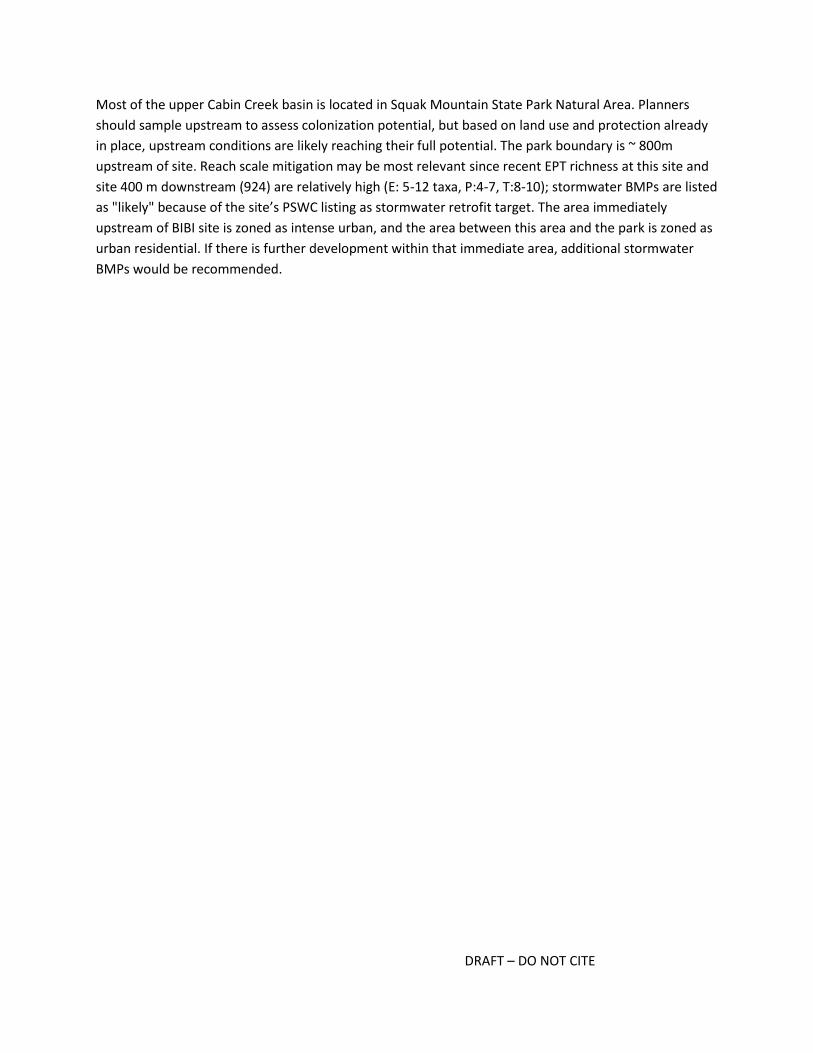
Most of the upper Cabin Creek basin is located in Squak Mountain State Park Natural Area. Planners
should sample upstream to assess colonization potential, but based on land use and protection already
in place, upstream conditions are likely reaching their full potential. The park boundary is ~ 800m
upstream of site. Reach scale mitigation may be most relevant since recent EPT richness at this site and
site 400 m downstream (924) are relatively high (E: 5-12 taxa, P:4-7, T:8-10); stormwater BMPs are listed
as "likely" because of the site’s PSWC listing as stormwater retrofit target. The area immediately
upstream of BIBI site is zoned as intense urban, and the area between this area and the park is zoned as
urban residential. If there is further development within that immediate area, additional stormwater
BMPs would be recommended.
DRAFT – DO NOT CITE
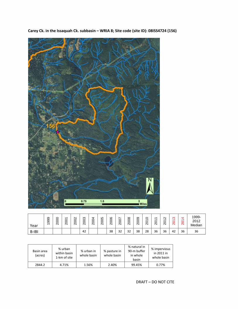
Carey Ck. in the Issaquah Ck. subbasin – WRIA 8; Site code (site ID): 08ISS4724 (156)
Year 19
99
20
00
20
01
20
02
20
03
20
04
20
05
20
06
20
07
20
08
20
09
20
10
20
11
20
12
20
13
20
14 1999-
2012 Median
B-IBI 42 38 32 32 38 28 36 36 42 36 36
Basin area (acres)
% urban within basin 1-km of site
% urban in whole basin
% pasture in whole basin
% natural in 90-m buffer
in whole basin
% impervious in 2011 in
whole basin
2844.2 4.71% 1.56% 2.40% 99.45% 0.77%

DRAFT – DO NOT CITE
Potential restoration or management actions for: Carey Ck. in the Issaquah Ck. subbasin – WRIA 8; Site
code (site ID): 08ISS4724 (156)
Restoration and Management Actions Likelihood action
would help restore the basin
In-stream
add wood 2
add substrate 2
enhance sinuosity 4
replace culverts 2
stabilize stream banks 2
Riparian stabilize slopes 2
plant vegetation, extend buffer 4
Agricultural BMPs
exclude livestock 2
manage waste 2
manage soil loss 1
Forest BMPs
road maintenance 2
minimize clearcutting 3
replant 1
Mining BMPs mining BMPs 0
Stormwater BMPs
flow controls 3
treatment 2
maintain storage and treatment facilities 1
street sweeping 1
Programmatic BMPs
limit pesticide use 2
outreach and education campaign 2
create incentives to follow BMPs 2
purchase and protect property 2
seed invertebrates 0
Is the basin at risk of further degradation? 4
Key for colors and numbers used in table:
not applicable unlikely possibly likely highly likely
0 1 2 3 4
Key restoration or management action(s) recommended and summary notes:
Local instream and/or Agricultural BMPs; increased channel complexity and planting of riparian
vegetation where applicable

DRAFT – DO NOT CITE
Nearly half of the Carey Creek basin is in Taylor Mountain Forest; photos indicate a history of clear
cutting but a site 4 km upstream (and downstream of the cutting) has scored excellent in 4 of 5 last
years. At a BIBI site ~2.5 km upstream of site #156, scores have ranged from poor to excellent over last 5
years. This suggests upstream conditions (within ~3 km of 156) are variable and may be contributing to
fair scores. Local impacts from small scale agriculture and rural residential may have contributed to the
fair scores at 156. Although logging does not appear to explain the decline at this site, minimizing future
harvest impacts will help ensure there is a source of diverse insects and sufficient organic matter from
upstream. Rural residential zoning throughout portions of the watershed, that are not currently
developed, suggests impacts may increase over time.

DRAFT – DO NOT CITE
Laughing Jacobs Ck. in the E Lake Sammamish subbasin – WRIA 8; Site code (site ID): 08LAK3879 (168)
Year 19
99
20
00
20
01
20
02
20
03
20
04
20
05
20
06
20
07
20
08
20
09
20
10
20
11
20
12
20
13
20
14 1999-
2012 Median
B-IBI 28 28 28 28 30 22 32 30 30 28 28 30 28
Basin area (acres)
% urban within basin 1-km of site
% urban in whole basin
% pasture in whole basin
% natural in 90-m buffer
in whole basin
% impervious in 2011 in
whole basin
2869.8 51.64% 45.73% 0.01% 53.45% 22.19%

DRAFT – DO NOT CITE
Potential restoration or management actions for: Laughing Jacobs Ck. in the E Lake Sammamish
subbasin – WRIA 8; Site code (site ID): 08LAK3879 (168)
Restoration and Management Actions Likelihood action
would help restore the basin
In-stream
add wood 4
add substrate 4
enhance sinuosity 4
replace culverts 4
stabilize stream banks 2
Riparian stabilize slopes 3
plant vegetation, extend buffer 4
Agricultural BMPs
exclude livestock 2
manage waste 2
manage soil loss 1
Forest BMPs
road maintenance 0
minimize clearcutting 0
replant 0
Mining BMPs mining BMPs 0
Stormwater BMPs
flow controls 4
treatment 4
maintain storage and treatment facilities 4
street sweeping 3
Programmatic BMPs
limit pesticide use 3
outreach and education campaign 3
create incentives to follow BMPs 2
purchase and protect property 2
seed invertebrates 2
Is the basin at risk of further degradation? 4
Key for colors and numbers used in table:
not applicable unlikely possibly likely highly likely
0 1 2 3 4
Key restoration or management action(s) recommended and summary notes:
Stormwater BMPs; riparian planting and extension of buffers; agricultural BMPs; in-stream restoration
actions

DRAFT – DO NOT CITE
The B-IBI site in the Laughing Jacob's basin is in Hans Jensen Park. At the site, the habitat is relatively
complex with some large woody debris in the channel, but the substrate is reportedly embedded.
Around the immediate site, the riparian habitat is excellent. Within 0.75-1 km, however, there is high
density housing within 30-50 m from the creek. Throughout the basin, it appears there has been
extensive development from mid 1980s through late 1990s, dominated by high density housing. Some
agricultural land persists ~2km upstream of the site, and it appears some improvements could be made,
such as establishing a buffer and restoring sinuosity. The PSWC analysis indicated water flow and water
quality processes have been degraded at the basin-scale and would benefit from restoration. The
Kokanee work group has developed a blueprint for this creek which has recommendations for
restoration projects that would occur downstream of the BIBI site; potential actions include replacing a
culvert under the Parkway, rerouting the lower reach or restoring in-channel habitat to improve
spawning habitat for Kokanee, and enhancing the stream channel within Hans Jensen Park by installing
pool-forming structures and adding spawning gravel. Most BIBI sites in adjacent watersheds have fair
BIBI scores; local managers suggested there should be diverse invertebrates in the area, but data from
other sites suggest there are no connected or nearby sources of diverse and sensitive invertebrate taxa.

DRAFT – DO NOT CITE
Fifteenmile Ck. in the Issaquah Ck. subbasin – WRIA 8; Site code (site ID): E1139 (306)
Year 19
99
20
00
20
01
20
02
20
03
20
04
20
05
20
06
20
07
20
08
20
09
20
10
20
11
20
12
20
13
20
14 1999-
2012 Median
B-IBI 22 26 36 38 30 34 40 36 38 42 32 32 35
Basin area (acres)
% urban within basin 1-km of site
% urban in whole basin
% pasture in whole basin
% natural in 90-m buffer
in whole basin
% impervious in 2011 in
whole basin
2996.5 21.29% 5.61% 0.77% 92.63% 2.26%
DRAFT – DO NOT CITE
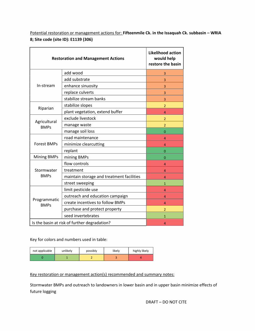
Potential restoration or management actions for: Fifteenmile Ck. in the Issaquah Ck. subbasin – WRIA
8; Site code (site ID): E1139 (306)
Restoration and Management Actions Likelihood action
would help restore the basin
In-stream
add wood 3
add substrate 3
enhance sinuosity 3
replace culverts 3
stabilize stream banks 3
Riparian stabilize slopes 2
plant vegetation, extend buffer 4
Agricultural BMPs
exclude livestock 2
manage waste 2
manage soil loss 0
Forest BMPs
road maintenance 4
minimize clearcutting 4
replant 0
Mining BMPs mining BMPs 0
Stormwater BMPs
flow controls 4
treatment 4
maintain storage and treatment facilities 4
street sweeping 1
Programmatic BMPs
limit pesticide use 4
outreach and education campaign 4
create incentives to follow BMPs 4
purchase and protect property 2
seed invertebrates 1
Is the basin at risk of further degradation? 4
Key for colors and numbers used in table:
not applicable unlikely possibly likely highly likely
0 1 2 3 4
Key restoration or management action(s) recommended and summary notes:
Stormwater BMPs and outreach to landowners in lower basin and in upper basin minimize effects of
future logging

DRAFT – DO NOT CITE
The upper 70% of the Fifteenmile Creek basin is zoned forest resource and the lower 30% is zoned rural
residential. Photos from 2006 indicate there had been some clearing (likely between 1995 and 2005),
but 2013 photos suggest there has not been extensive clearing since. The majority of the basin had been
logged previously, but it is uncertain when it would likely be logged again. In the lower basin, most of
the homes were built on 0.5 to 5-acre lots between 1960 and 1985 and therefore it is likely that the
installation of current stormwater BMPs could improve flow processes. Most, if not all, properties
appear to have septic systems, and several properties in the lower basin are within 30 m of the stream.
Stormwater runoff from the Issaquah-Hobart Road could also be affecting stream conditions in the 1-km
basin upstream of the site. Managers familiar with the site also suggested local restoration may be
beneficial.

DRAFT – DO NOT CITE
May Ck. (Lake Washington) in the May Ck. subbasin – WRIA 8; Site code (site ID): P325 (320)
Year 19
99
20
00
20
01
20
02
20
03
20
04
20
05
20
06
20
07
20
08
20
09
20
10
20
11
20
12
20
13
20
14 1999-
2012 Median
B-IBI 32 34 36 40 36 36 30 36
Basin area (acres)
% urban within basin 1-km of site
% urban in whole basin
% pasture in whole basin
% natural in 90-m buffer
in whole basin
% impervious in 2011 in
whole basin
682.6 8.58% 11.74% 0.00% 87.80% 4.15%

DRAFT – DO NOT CITE
Potential restoration or management actions for: May Ck. (Lake Washington) in the May Ck. subbasin –
WRIA 8; Site code (site ID): P325 (320)
Restoration and Management Actions Likelihood action
would help restore the basin
In-stream
add wood 2
add substrate 2
enhance sinuosity 2
replace culverts 2
stabilize stream banks 2
Riparian stabilize slopes 2
plant vegetation, extend buffer 2
Agricultural BMPs
exclude livestock 0
manage waste 0
manage soil loss 0
Forest BMPs
road maintenance 0
minimize clearcutting 0
replant 0
Mining BMPs mining BMPs 0
Stormwater BMPs
flow controls 4
treatment 4
maintain storage and treatment facilities 4
street sweeping 1
Programmatic BMPs
limit pesticide use 3
outreach and education campaign 4
create incentives to follow BMPs 3
purchase and protect property 1
seed invertebrates 3
Is the basin at risk of further degradation? 4
Key for colors and numbers used in table:
not applicable unlikely possibly likely highly likely
0 1 2 3 4
Key restoration or management action(s) recommended and summary notes:
Stormwater BMPs and outreach

DRAFT – DO NOT CITE
Most of the basin of this tributary of May Creek is zoned rural residential, though the upper third of the
basin appears to be within the Cougar Mountain Regional Wildland Park. If upper watershed is not a
source of diverse invertebrates, this site might be a good candidate for seeding once additional
stormwater BMPs are installed. The basin has been identified by PSWC and KC as a priority for
stormwater BMPs, and restoration actions in the mainstem of May Creek indicate actions on this
tributary may contribute to efforts in the larger watershed. Parcels near the east tributary are relatively
large (1-7 acres), with most homes built between 1975 and 1995. Parcels near the west tributary are
smaller and some of the homes are newer. There appear to be 8 residential stormwater facilities within
the basin, but additional stormwater BMPs would likely benefit discharge processes. Outreach to
homeowners would also be advantageous.

DRAFT – DO NOT CITE
Stensland Ck. in the Bear Ck. subbasin – WRIA 8; Site code (site ID): Stensland Middle (947)
Year 19
99
20
00
20
01
20
02
20
03
20
04
20
05
20
06
20
07
20
08
20
09
20
10
20
11
20
12
20
13
20
14 1999-
2012 Median
B-IBI 30 38 32 30 28 31
Basin area (acres)
% urban within basin 1-km of site
% urban in whole basin
% pasture in whole basin
% natural in 90-m buffer
in whole basin
% impervious in 2011 in
whole basin
400.1 16.23% 28.69% 7.08% 52.29% 12.67%

DRAFT – DO NOT CITE
Potential restoration or management actions for: Stensland Ck. in the Bear Ck. subbasin – WRIA 8; Site
code (site ID): Stensland Middle (947)
Restoration and Management Actions Likelihood action
would help restore the basin
In-stream
add wood 2
add substrate 2
enhance sinuosity 2
replace culverts 2
stabilize stream banks 2
Riparian stabilize slopes 2
plant vegetation, extend buffer 4
Agricultural BMPs
exclude livestock 3
manage waste 2
manage soil loss 2
Forest BMPs
road maintenance 0
minimize clearcutting 0
replant 0
Mining BMPs mining BMPs 0
Stormwater BMPs
flow controls 4
treatment 4
maintain storage and treatment facilities 4
street sweeping 2
Programmatic BMPs
limit pesticide use 3
outreach and education campaign 3
create incentives to follow BMPs 3
purchase and protect property 2
seed invertebrates 3
Is the basin at risk of further degradation? 3
Key for colors and numbers used in table:
not applicable unlikely possibly likely highly likely
0 1 2 3 4
Key restoration or management action(s) recommended and summary notes:
Stormwater and agricultural BMPs, extending and planting riparian areas, outreach, seeding

DRAFT – DO NOT CITE
The Stensland Creek basin is zoned exclusively rural residential, and the basin appears to be developed
accordingly. Homes range widely in age, with some built before any stormwater regulations were
recommended and others built in the 2000s. Most of the homes appear to be on septic systems. The
creek flows under a road (196th Ave NE) and along a large roadway (NE Novelty Hill Rd.) with a small
buffer (20 to 25 m per side) for nearly 800 m upstream of the site. Upstream of the sparse wooded area
by the road, the creek runs through pastures with little to no riparian buffer. The buffer width increases
in parts of the upper basin, but stormwater runoff from the residential area in the upper basin likely
affects the water flow and water quality processes at the basin scale. Coho use the stream, and they and
invertebrates would likely benefit from stormwater BMPs throughout the basin, agricultural BMPs
(especially in the lower 1-km basin), and extending and planting in the riparian areas. Outreach to
landowners, and especially those with large parcels adjacent to the creek, could encourage agricultural
BMPs. Seeding may be appropriate after BMPs are established.
DRAFT – DO NOT CITE
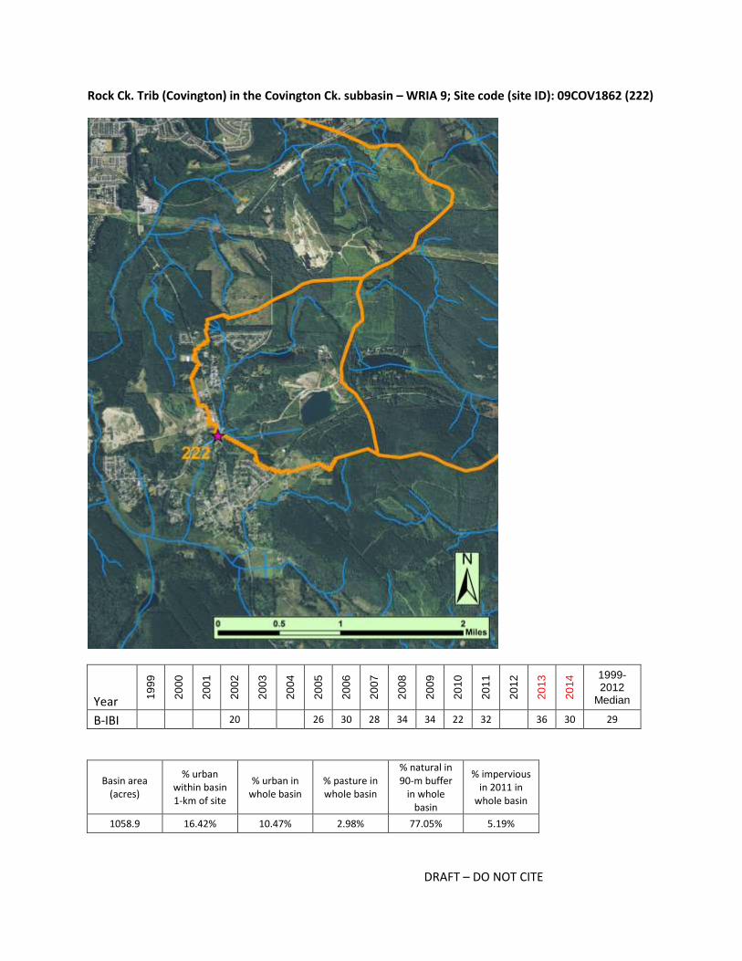
Rock Ck. Trib (Covington) in the Covington Ck. subbasin – WRIA 9; Site code (site ID): 09COV1862 (222)
Year 19
99
20
00
20
01
20
02
20
03
20
04
20
05
20
06
20
07
20
08
20
09
20
10
20
11
20
12
20
13
20
14 1999-
2012 Median
B-IBI 20 26 30 28 34 34 22 32 36 30 29
Basin area (acres)
% urban within basin 1-km of site
% urban in whole basin
% pasture in whole basin
% natural in 90-m buffer
in whole basin
% impervious in 2011 in
whole basin
1058.9 16.42% 10.47% 2.98% 77.05% 5.19%

DRAFT – DO NOT CITE
Potential restoration or management actions for: Rock Ck. Trib (Covington) in the Covington Ck.
subbasin – WRIA 9; Site code (site ID): 09COV1862 (222)
Restoration and Management Actions Likelihood action
would help restore the basin
In-stream
add wood 2
add substrate 2
enhance sinuosity 2
replace culverts 2
stabilize stream banks 2
Riparian stabilize slopes 2
plant vegetation, extend buffer 2
Agricultural BMPs
exclude livestock 2
manage waste 1
manage soil loss 0
Forest BMPs
road maintenance 3
minimize clearcutting 4
replant 2
Mining BMPs mining BMPs 4
Stormwater BMPs
flow controls 3
treatment 3
maintain storage and treatment facilities 3
street sweeping 1
Programmatic BMPs
limit pesticide use 2
outreach and education campaign 3
create incentives to follow BMPs 2
purchase and protect property 2
seed invertebrates 2
Is the basin at risk of further degradation? 4
Key for colors and numbers used in table:
not applicable unlikely possibly likely highly likely
0 1 2 3 4
Key restoration or management action(s) recommended and summary notes:
Stormwater, Forest and mining BMPs, outreach

DRAFT – DO NOT CITE
Of all the basins considered, the basin for the Rock Creek tributary in Covington has the most varied land
uses and associated zoning. There is rural residential development, higher density urban development
(e.g., housing development built in 1990s and mobile home park), active forest harvest, active mining,
and small scale agriculture within the rural residential areas. Therefore, it is plausible that BMPs related
to all of these land uses could apply. BMPs that limit sediment delivery are recommended because it has
been reported that the substrate at the BIBI site is dominated by fine sediments. Summer flows are
often low, and macroinvertebrate community may be limited by slow water and limited habitat. PSWC
processes analysis suggested basin-scale actions may be needed to restore water flow and water quality
processes. Of the areas zoned for urban development, only a small portion has been developed thus far,
especially in the southwest portion of basin. If development proceeds, stormwater BMPs should be
utilized as much as possible to reduce impacts of increased impervious surfaces. In-channel restorations
actions may also be needed throughout the basin given the history of logging and the likely impacts on
habitat structure and complexity.
DRAFT – DO NOT CITE
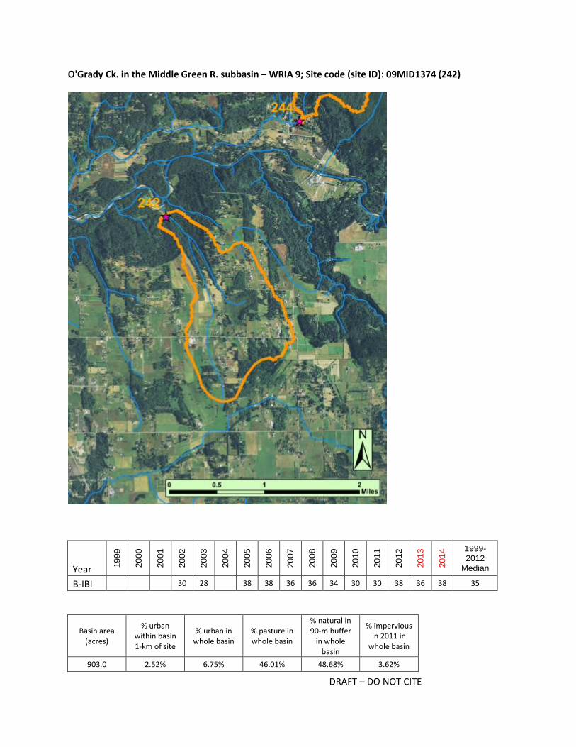
O'Grady Ck. in the Middle Green R. subbasin – WRIA 9; Site code (site ID): 09MID1374 (242)
Year 19
99
20
00
20
01
20
02
20
03
20
04
20
05
20
06
20
07
20
08
20
09
20
10
20
11
20
12
20
13
20
14 1999-
2012 Median
B-IBI 30 28 38 38 36 36 34 30 30 38 36 38 35
Basin area (acres)
% urban within basin 1-km of site
% urban in whole basin
% pasture in whole basin
% natural in 90-m buffer
in whole basin
% impervious in 2011 in
whole basin
903.0 2.52% 6.75% 46.01% 48.68% 3.62%

DRAFT – DO NOT CITE
Potential restoration or management actions for: O'Grady Ck. in the Middle Green R. subbasin – WRIA
9; Site code (site ID): 09MID1374 (242)
Restoration and Management Actions Likelihood action
would help restore the basin
In-stream
add wood 2
add substrate 1
enhance sinuosity 3
replace culverts 2
stabilize stream banks 2
Riparian stabilize slopes 3
plant vegetation, extend buffer 4
Agricultural BMPs
exclude livestock 3
manage waste 3
manage soil loss 3
Forest BMPs
road maintenance 0
minimize clearcutting 0
replant 0
Mining BMPs mining BMPs 0
Stormwater BMPs
flow controls 2
treatment 2
maintain storage and treatment facilities 2
street sweeping 2
Programmatic BMPs
limit pesticide use 3
outreach and education campaign 3
create incentives to follow BMPs 3
purchase and protect property 0
seed invertebrates 3
Is the basin at risk of further degradation? 2
Key for colors and numbers used in table:
not applicable unlikely possibly likely highly likely
0 1 2 3 4
Key restoration or management action(s) recommended and summary notes:
Agricultural BMPs upstream, with increased riparian buffers; channel restoration targeting sand
deposition, seeding

DRAFT – DO NOT CITE
The O'Grady Creek basin is the only basin with a "fair" median score that is zoned exclusively for
resource agriculture. Within the immediate 1-km basin, the channel has a relatively intact riparian zone.
It is unlikely that land cover will change in this reach or forest would be cleared because of the steep
topography. The reach just above the BIBI site was restored in 1999-2001, with a culvert replacement
and channel restoration. Local in-stream conditions appear to be good, though local managers also
report that the reach may be affected by deposition and scouring of sand during high flow events.
Restoration actions to reduce high flows and dissipate energy upstream of the site may be helpful. At
basin scale, the PSWC analysis suggested some flow and water quality processes are highly degraded
and may require extensive restoration while others may be easier to restore. Agricultural land (with no
buffers) starts ~1.5km upstream of site, and agricultural BMPS are highly recommended in these
reaches. Land is classified as APD land, so adding extensive buffers in upper watershed may be
unfeasible. Seeding may be appropriate f the risk of scouring can be reduced.
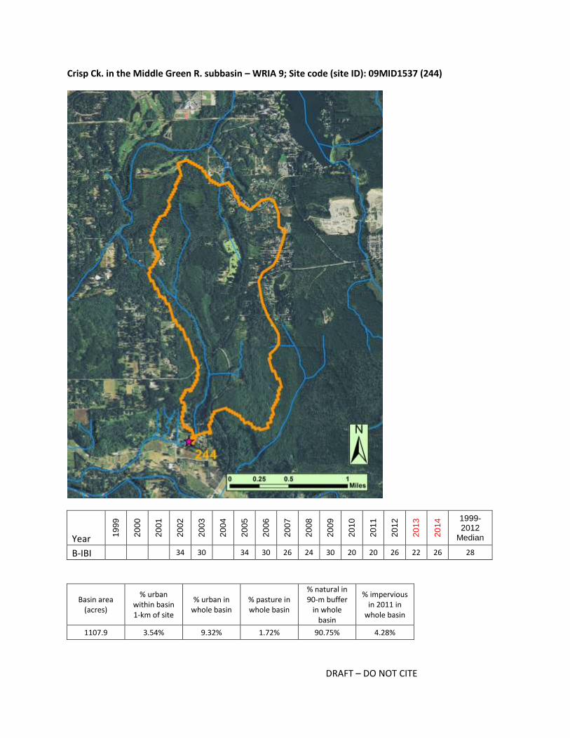
DRAFT – DO NOT CITE
Crisp Ck. in the Middle Green R. subbasin – WRIA 9; Site code (site ID): 09MID1537 (244)
Year 19
99
20
00
20
01
20
02
20
03
20
04
20
05
20
06
20
07
20
08
20
09
20
10
20
11
20
12
20
13
20
14 1999-
2012 Median
B-IBI 34 30 34 30 26 24 30 20 20 26 22 26 28
Basin area (acres)
% urban within basin 1-km of site
% urban in whole basin
% pasture in whole basin
% natural in 90-m buffer
in whole basin
% impervious in 2011 in
whole basin
1107.9 3.54% 9.32% 1.72% 90.75% 4.28%

DRAFT – DO NOT CITE
Potential restoration or management actions for: Crisp Ck. in the Middle Green R. subbasin – WRIA 9;
Site code (site ID): 09MID1537 (244)
Restoration and Management Actions Likelihood action
would help restore the basin
In-stream
add wood 4
add substrate 4
enhance sinuosity 4
replace culverts 4
stabilize stream banks 4
Riparian stabilize slopes 4
plant vegetation, extend buffer 4
Agricultural BMPs
exclude livestock 0
manage waste 0
manage soil loss 0
Forest BMPs
road maintenance 3
minimize clearcutting 4
replant 1
Mining BMPs mining BMPs 0
Stormwater BMPs
flow controls 4
treatment 4
maintain storage and treatment facilities 3
street sweeping 1
Programmatic BMPs
limit pesticide use 3
outreach and education campaign 3
create incentives to follow BMPs 3
purchase and protect property 4
seed invertebrates 2
Is the basin at risk of further degradation? 4
Key for colors and numbers used in table:
not applicable unlikely possibly likely highly likely
0 1 2 3 4
Key restoration or management action(s) recommended and summary notes:
Reach-scale restoration, Stormwater BMPs

DRAFT – DO NOT CITE
The Crisp Creek basin is zoned exclusively for rural residential although several parcels in the central part
of the basin are designated forest land in the King County Assessor's report. Within ~500 m of the BIBI
site, the channel is ditched and flows along gravel roads. Riparian cover in this lower reach is limited to
reed canary grass and blackberry. Reach-scale restoration actions should likely include restoring channel
sinuosity, adding structure to increase habitat complexity, and restoring the riparian zone. The reach
above this is likely in better condition, though in-channel restorations actions may be needed as well
due to previous impacts of logging and naturally high sediment loads. Starting about 500-m upstream of
the BIBI site, the creek flows through the Black Diamond Natural Area. The forest in the central basin
appears to be relatively young (i.e., recently cleared patches are visible in the 2006 photos). If existing
forest patches are cleared (for harvest or development), forest and/or construction BMPs should be
employed as much as possible. The development in the basin ranges in age (1960s - 2010s), and while
there are stormwater ponds in areas with newer development, additional stormwater BMPs may be
helpful. If invertebrate communities upstream are diverse, it may be relatively easy to improve site
conditions and allow for colonization from upstream. If invertebrate communities upstream are not
diverse, seeding may be appropriate once site conditions are restored.
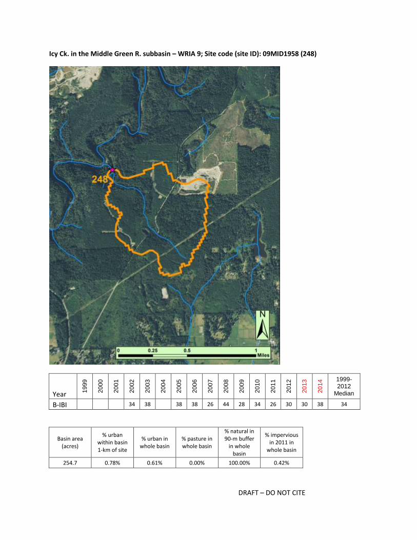
DRAFT – DO NOT CITE
Icy Ck. in the Middle Green R. subbasin – WRIA 9; Site code (site ID): 09MID1958 (248)
Year 19
99
20
00
20
01
20
02
20
03
20
04
20
05
20
06
20
07
20
08
20
09
20
10
20
11
20
12
20
13
20
14 1999-
2012 Median
B-IBI 34 38 38 38 26 44 28 34 26 30 30 38 34
Basin area (acres)
% urban within basin 1-km of site
% urban in whole basin
% pasture in whole basin
% natural in 90-m buffer
in whole basin
% impervious in 2011 in
whole basin
254.7 0.78% 0.61% 0.00% 100.00% 0.42%

DRAFT – DO NOT CITE
Potential restoration or management actions for: Icy Ck. in the Middle Green R. subbasin – WRIA 9; Site
code (site ID): 09MID1958 (248)
Restoration and Management Actions Likelihood action
would help restore the basin
In-stream
add wood 3
add substrate 0
enhance sinuosity 2
replace culverts 2
stabilize stream banks 1
Riparian stabilize slopes 1
plant vegetation, extend buffer 1
Agricultural BMPs
exclude livestock 0
manage waste 0
manage soil loss 0
Forest BMPs
road maintenance 0
minimize clearcutting 0
replant 0
Mining BMPs mining BMPs 0
Stormwater BMPs
flow controls 3
treatment 3
maintain storage and treatment facilities 3
street sweeping 0
Programmatic BMPs
limit pesticide use 1
outreach and education campaign 1
create incentives to follow BMPs 1
purchase and protect property 4
seed invertebrates 2
Is the basin at risk of further degradation? 4
Key for colors and numbers used in table:
not applicable unlikely possibly likely highly likely
0 1 2 3 4
Key restoration or management action(s) recommended and summary notes:
Protect conditions as much as possible, in-channel restoration

DRAFT – DO NOT CITE
The Icy Creek basin has been identified by both PSWC and King County as a candidate for stormwater
retrofits, although there is almost no current development in the basin. Some history of forest harvest
is apparent in photos, but PSWC process scores indicate degradation is not at the landscape-scale. New
paved roads suggest development may be imminent. Staff who have sampled the site report it is in a
steep ravine and the substrate is dominated by large cobble. Although there have been a sufficient
number of insects collected here (in 10 of the last 12 years there have been 500 or more per sample),
the composition of the community may be limited by the local habitat. For example, a relatively rare
caddisfly, Oligophlebodes, typically found in the most turbulent sections of streams was the most
abundant taxa in most samples. The focus should be on preventing further decline if and when
development proceeds.

DRAFT – DO NOT CITE
Newaukum Ck. - N Fork in the Newaukum Ck. subbasin – WRIA 9; Site code (site ID): 09NEW2128 (260)
Year 19
99
20
00
20
01
20
02
20
03
20
04
20
05
20
06
20
07
20
08
20
09
20
10
20
11
20
12
20
13
20
14 1999-
2012 Median
B-IBI 30 32 36 26 46 38 38 32 30 36 44 36 34
Basin area (acres)
% urban within basin 1-km of site
% urban in whole basin
% pasture in whole basin
% natural in 90-m buffer
in whole basin
% impervious in 2011 in
whole basin
1409.6 1.91% 0.76% 0.08% 99.04% 0.39%

DRAFT – DO NOT CITE
Potential restoration or management actions for: Newaukum Ck. - N Fork in the Newaukum Ck.
subbasin – WRIA 9; Site code (site ID): 09NEW2128 (260)
Restoration and Management Actions Likelihood action
would help restore the basin
In-stream
add wood 4
add substrate 2
enhance sinuosity 4
replace culverts 2
stabilize stream banks 3
Riparian stabilize slopes 3
plant vegetation, extend buffer 3
Agricultural BMPs
exclude livestock 0
manage waste 0
manage soil loss 0
Forest BMPs
road maintenance 2
minimize clearcutting 4
replant 4
Mining BMPs mining BMPs 0
Stormwater BMPs
flow controls 0
treatment 0
maintain storage and treatment facilities 0
street sweeping 0
Programmatic BMPs
limit pesticide use 2
outreach and education campaign 0
create incentives to follow BMPs 2
purchase and protect property 2
seed invertebrates 1
Is the basin at risk of further degradation? 4
Key for colors and numbers used in table:
not applicable unlikely possibly likely highly likely
0 1 2 3 4
Key restoration or management action(s) recommended and summary notes:
Forest BMPs, channel restoration

DRAFT – DO NOT CITE
Most of the basin of the North Fork of Newaukum Creek is zoned for resource forest, and there have
been large clearcuts throughout the basin since 2006. PSWC process analysis indicates surface storage
has been degraded, and this corroborates on-site observations that the channel is down cut at the BIBI
site. Restoration actions designed to control flows and sediment transport from logged lands would be
most appropriate, and would likely be needed at the landscape-scale. Although surface storage
processes have been disrupted by logging rather than urban development, the site has been prioritized
by King County for stormwater retrofits. Photos illustrate buffers were maintained along stream corridor
in logged areas; the typical buffer appears to be ~35 to 50 m on each side of the channel. In-channel
restoration at site would likely include LWD additions, channel widening and bank stabilization to
enhance fish and invertebrate habitat.

DRAFT – DO NOT CITE
Soosette Ck. in the Soos Ck. subbasin – WRIA 9; Site code (site ID): 09SOO1022 (264)
Year 19
99
20
00
20
01
20
02
20
03
20
04
20
05
20
06
20
07
20
08
20
09
20
10
20
11
20
12
20
13
20
14 1999-
2012 Median
B-IBI 28 36 32 30 40 38 32 34 36 36 28 34
Basin area (acres)
% urban within basin 1-km of site
% urban in whole basin
% pasture in whole basin
% natural in 90-m buffer
in whole basin
% impervious in 2011 in
whole basin
2797.4 27.67% 56.44% 8.47% 30.94% 28.38%

DRAFT – DO NOT CITE
Potential restoration or management actions for: Soosette Ck. in the Soos Ck. subbasin – WRIA 9; Site
code (site ID): 09SOO1022 (264)
Restoration and Management Actions Likelihood action
would help restore the basin
In-stream
add wood 3
add substrate 3
enhance sinuosity 3
replace culverts 3
stabilize stream banks 3
Riparian stabilize slopes 4
plant vegetation, extend buffer 4
Agricultural BMPs
exclude livestock 3
manage waste 3
manage soil loss 2
Forest BMPs
road maintenance 0
minimize clearcutting 0
replant 0
Mining BMPs mining BMPs 0
Stormwater BMPs
flow controls 3
treatment 3
maintain storage and treatment facilities 3
street sweeping 3
Programmatic BMPs
limit pesticide use 2
outreach and education campaign 3
create incentives to follow BMPs 3
purchase and protect property 1
seed invertebrates 1
Is the basin at risk of further degradation? 1
Key for colors and numbers used in table:
not applicable unlikely possibly likely highly likely
0 1 2 3 4
Key restoration or management action(s) recommended and summary notes:
Stormwater and agricultural BMPs; in-channel habitat and riparian actions

DRAFT – DO NOT CITE
The Soosette Creek basin is highly developed with housing developments from the 1970s through the
2000s. The biopotential score of +6 indicates the BIBI scores are relatively high given the development
and extent of impervious surface. Likewise, the PSWC analysis suggested flow and water quality are
highly degraded across the basin and BIBI scores are higher than expected given that degradation. The
basin is known for having high water temperatures, and the BIBI reach has a 303(d) listing for fecal
coliform. The City of Kent has done some restoration actions, but many additional local and basin-scale
actions would be warranted. It is unclear why the BIBI score has remained as high as it has, and
consequently it appears the chance of improving the score is small.

DRAFT – DO NOT CITE
Christenson Ck. in the Vashon-Maury Island subbasin – WRIA 9; Site code (site ID): VashChris (272)
Year 19
99
20
00
20
01
20
02
20
03
20
04
20
05
20
06
20
07
20
08
20
09
20
10
20
11
20
12
20
13
20
14 1999-
2012 Median
B-IBI 28 34 32 22 34 34 26 34 32 40 33
Basin area (acres)
% urban within basin 1-km of site
% urban in whole basin
% pasture in whole basin
% natural in 90-m buffer
in whole basin
% impervious in 2011 in
whole basin
500.8 0.16% 2.66% 25.44% 100.00% 1.72%

DRAFT – DO NOT CITE
Potential restoration or management actions for: Christenson Ck. in the Vashon-Maury Island subbasin
– WRIA 9; Site code (site ID): VashChris (272)
Restoration and Management Actions Likelihood action
would help restore the basin
In-stream
add wood 3
add substrate 3
enhance sinuosity 1
replace culverts 1
stabilize stream banks 1
Riparian stabilize slopes 1
plant vegetation, extend buffer 1
Agricultural BMPs
exclude livestock 2
manage waste 2
manage soil loss 0
Forest BMPs
road maintenance 0
minimize clearcutting 0
replant 0
Mining BMPs mining BMPs 0
Stormwater BMPs
flow controls 0
treatment 0
maintain storage and treatment facilities 0
street sweeping 0
Programmatic BMPs
limit pesticide use 3
outreach and education campaign 3
create incentives to follow BMPs 3
purchase and protect property 2
seed invertebrates 4
Is the basin at risk of further degradation? 3
Key for colors and numbers used in table:
not applicable unlikely possibly likely highly likely
0 1 2 3 4
Key restoration or management action(s) recommended and summary notes:
Bug seeding, programmatic BMPs

DRAFT – DO NOT CITE
The BIBI site in the Christenson Creek basin is at the base of a steep forested ravine in a small watershed
on Vashon. Zoning is primarily rural residential, and it is unknown if further development would be
permitted or expected. Slightly less than 20% of the basin is zoned for resource agriculture, and photos
indicate small farms and clearings around houses account for the pasture land. The riparian buffer
appears to be largely intact. Programmatic BMPs and bug seeding may be helpful in this basin. There is
local interest in the creek; it was included in the "bio blitz" which is a 24-hour organism count from pond
to the creek's mouth organized by the Vashon Nature Center.

DRAFT – DO NOT CITE
Judd Ck. in the Vashon-Maury Island subbasin – WRIA 9; Site code (site ID): VashJudd (273)
Year 19
99
20
00
20
01
20
02
20
03
20
04
20
05
20
06
20
07
20
08
20
09
20
10
20
11
20
12
20
13
20
14 1999-
2012 Median
B-IBI 30 30 30 32 24 32 34 30
Basin area (acres)
% urban within basin 1-km of site
% urban in whole basin
% pasture in whole basin
% natural in 90-m buffer
in whole basin
% impervious in 2011 in
whole basin
2754.6 1.97% 4.79% 11.44% 85.69% 3.19%

DRAFT – DO NOT CITE
Potential restoration or management actions for: Judd Ck. in the Vashon-Maury Island subbasin –
WRIA 9; Site code (site ID): VashJudd (273)
Restoration and Management Actions Likelihood action
would help restore the basin
In-stream
add wood 3
add substrate 3
enhance sinuosity 2
replace culverts 3
stabilize stream banks 3
Riparian stabilize slopes 2
plant vegetation, extend buffer 4
Agricultural BMPs
exclude livestock 3
manage waste 2
manage soil loss 2
Forest BMPs
road maintenance 0
minimize clearcutting 0
replant 0
Mining BMPs mining BMPs 0
Stormwater BMPs
flow controls 4
treatment 4
maintain storage and treatment facilities 3
street sweeping 1
Programmatic BMPs
limit pesticide use 3
outreach and education campaign 3
create incentives to follow BMPs 3
purchase and protect property 2
seed invertebrates 3
Is the basin at risk of further degradation? 2
Key for colors and numbers used in table:
not applicable
unlikely possibly likely highly likely
0 1 2 3 4
Key restoration or management action(s) recommended and summary notes:
Stormwater BMPs, extending and planting riparian area, outreach to encourage agricultural BMPs

DRAFT – DO NOT CITE
The Judd Creek basin is zoned primarily as rural residential; though photos indicate there are many
parcels with barns, pastures and some cultivation. Though the basin is not zoned for forest harvest,
there has been some selective logging. KC owns the Island Center Forest Natural Area in the upper
portion of the watershed. The basin was identified by KC as candidate for stormwater retrofit, but it was
ranked low and did not receive funding in 2015. PSWC processes scored "2" for surface storage and
discharge (and "1" for others), indicating stormwater BMPs throughout the basin could benefit flow
processes. There is interest and support for restoration actions in the basin, and some work has been
completed. For example, at the confluence about 1.5 km upstream of the BIBI site, land was purchased
in 2009 and the riparian area was replanted. The in-channel habitat at the site and immediately
upstream and downstream is reported to be good, but further improvements could be made. For
example, in the summer of 2015 a local land trust is adding wood to a reach below the BIBI site where
chum spawn. The best area for coho spawning is located above the site, and therefore in-channel
actions could improve habitat complexity to benefit invertebrates and the spawning and rearing of fish.
Outreach to landowners in the basin, and especially those with parcels adjacent to the stream, may be
appropriate to encourage agricultural BMPs and extending and planting riparian areas. Seeding may also
be appropriate given there are no connected or nearby sources of diverse and sensitive invertebrates.

DRAFT – DO NOT CITE
Tahlequah Ck. in the Vashon-Maury Island subbasin – WRIA 9; Site code (site ID): E2887 (354)
Year 19
99
20
00
20
01
20
02
20
03
20
04
20
05
20
06
20
07
20
08
20
09
20
10
20
11
20
12
20
13
20
14 1999-
2012 Median
B-IBI 22 24 32 34 32 28 24 28
Basin area (acres)
% urban within basin 1-km of site
% urban in whole basin
% pasture in whole basin
% natural in 90-m buffer
in whole basin
% impervious in 2011 in
whole basin
984.1 3.35% 4.93% 0.05% 99.26% 2.37%

DRAFT – DO NOT CITE
Potential restoration or management actions for: Tahlequah Ck. in the Vashon-Maury Island subbasin –
WRIA 9; Site code (site ID): E2887 (354)
Restoration and Management Actions Likelihood action
would help restore the basin
In-stream
add wood 3
add substrate 3
enhance sinuosity 3
replace culverts 2
stabilize stream banks 2
Riparian stabilize slopes 2
plant vegetation, extend buffer 1
Agricultural BMPs
exclude livestock 2
manage waste 0
manage soil loss 0
Forest BMPs
road maintenance 0
minimize clearcutting 0
replant 0
Mining BMPs mining BMPs 0
Stormwater BMPs
flow controls 3
treatment 3
maintain storage and treatment facilities 2
street sweeping 2
Programmatic BMPs
limit pesticide use 2
outreach and education campaign 2
create incentives to follow BMPs 2
purchase and protect property 2
seed invertebrates 4
Is the basin at risk of further degradation? 4
Key for colors and numbers used in table:
not applicable unlikely possibly likely highly likely
0 1 2 3 4
Key restoration or management action(s) recommended and summary notes:
Seeding, some stormwater BMPs along road, possibly in-channel restoration

DRAFT – DO NOT CITE
The Tahlequah Creek basin has a BIBI score that is considerably lower that what you might expect given
the land use. The basin is zoned exclusively for rural residential use, but there are relatively few roads
and homes near the stream and in the center of the basin. The age of homes varies considerably
(ranging from the 1960s through the 2000s), and the lot sizes range from 1 to 10+ acres. The PSWC
analysis suggests surface storage and discharge are degraded at the basin scale, and there may be some
opportunities for treating stormwater, especially along the Vashon Highway. Reach-scale actions could
also include controlling sediment and restoration of the channel as the lower portion of the creek is
confined. Also, given the young age of the forest, large woody debris may be needed to increase
complexity. The Vashon Nature Center conducts volunteer “Salmonwatcher” surveys in other creeks on
the island; volunteer activity may indicate local support for restoration actions and a group of
landowners that would be receptive to outreach efforts. The relatively low BIBI scores may reflect
previous logging impacts and the fact that there are no nearby or connected sources of diverse
invertebrates. Seeding may be an excellent action to try before attempting more expensive actions.
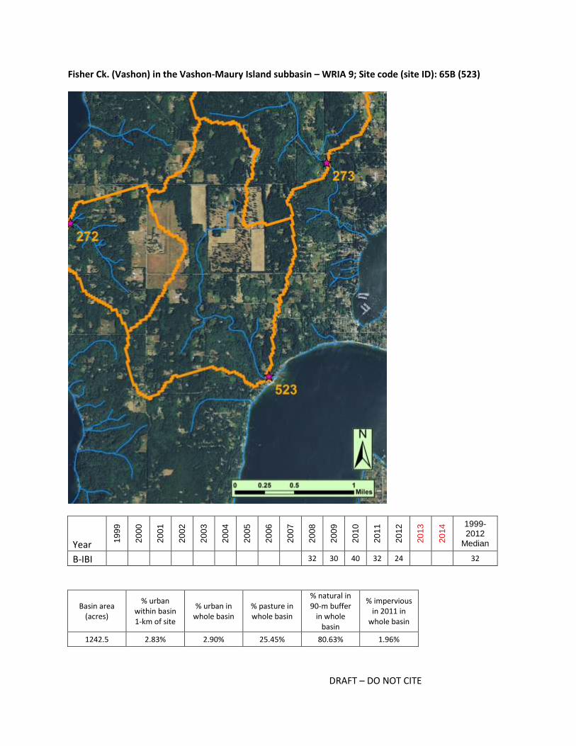
DRAFT – DO NOT CITE
Fisher Ck. (Vashon) in the Vashon-Maury Island subbasin – WRIA 9; Site code (site ID): 65B (523)
Year 19
99
20
00
20
01
20
02
20
03
20
04
20
05
20
06
20
07
20
08
20
09
20
10
20
11
20
12
20
13
20
14 1999-
2012 Median
B-IBI 32 30 40 32 24 32
Basin area (acres)
% urban within basin 1-km of site
% urban in whole basin
% pasture in whole basin
% natural in 90-m buffer
in whole basin
% impervious in 2011 in
whole basin
1242.5 2.83% 2.90% 25.45% 80.63% 1.96%

DRAFT – DO NOT CITE
Potential restoration or management actions for: Fisher Ck. (Vashon) in the Vashon-Maury Island
subbasin – WRIA 9; Site code (site ID): 65B (523)
Restoration and Management Actions Likelihood action
would help restore the basin
In-stream
add wood 4
add substrate 4
enhance sinuosity 3
replace culverts 2
stabilize stream banks 3
Riparian stabilize slopes 3
plant vegetation, extend buffer 3
Agricultural BMPs
exclude livestock 4
manage waste 3
manage soil loss 3
Forest BMPs
road maintenance 0
minimize clearcutting 0
replant 0
Mining BMPs mining BMPs 0
Stormwater BMPs
flow controls 2
treatment 2
maintain storage and treatment facilities 2
street sweeping 1
Programmatic BMPs
limit pesticide use 2
outreach and education campaign 3
create incentives to follow BMPs 3
purchase and protect property 2
seed invertebrates 4
Is the basin at risk of further degradation? 4
Key for colors and numbers used in table:
not applicable unlikely possibly likely highly likely
0 1 2 3 4
Key restoration or management action(s) recommended and summary notes:
Agricultural BMPs, in-channel restoration, seeding

DRAFT – DO NOT CITE
The Fisher Creek basin is similar to other basins on Vashon Island in that the land use is dominated by
rural residential and small farm agriculture. Also like other Vashon basins, the substrate at the BIBI site is
largely sand and finer sediment. The Vashon-Maury Island steward reported that 10 residents have
agriculture easements and that Misty Isle Farms (which owns 540 acres in the upper basin) started
managing an animal waste lagoon sometime between 2000 and 2005. BMPs that protect the riparian
buffer and target sediment delivery would likely be beneficial. In-channel restoration actions may also
be helpful in creating more complex habitat. Seeding may be appropriate as there are no known sources
of diverse taxa nearby.

DRAFT – DO NOT CITE
Spiketon Ck. in the S Prarie Ck. subbasin – WRIA 10; Site code (site ID): BiBi-033 - Spiketon Creek
(1099)
Year 19
99
20
00
20
01
20
02
20
03
20
04
20
05
20
06
20
07
20
08
20
09
20
10
20
11
20
12
20
13
20
14 1999-
2012 Median
B-IBI 32 34 26 30 32
Basin area (acres)
% urban within basin 1-km of site
% urban in whole basin
% pasture in whole basin
% natural in 90-m buffer
in whole basin
% impervious in 2011 in
whole basin
920.9 9.73% 5.12% 15.96% 86.45% 2.16%

DRAFT – DO NOT CITE
Potential restoration or management actions for: Spiketon Ck. in the S Prairie Ck. subbasin – WRIA 10;
Site code (site ID): BiBi-033 - Spiketon Creek (1099)
Restoration and Management Actions Likelihood action
would help restore the basin
In-stream
add wood 2
add substrate 2
enhance sinuosity 2
replace culverts 2
stabilize stream banks 2
Riparian stabilize slopes 2
plant vegetation, extend buffer 3
Agricultural BMPs
exclude livestock 3
manage waste 3
manage soil loss 2
Forest BMPs
road maintenance 2
minimize clearcutting 4
replant 2
Mining BMPs mining BMPs 0
Stormwater BMPs
flow controls 4
treatment 4
maintain storage and treatment facilities 4
street sweeping 1
Programmatic BMPs
limit pesticide use 3
outreach and education campaign 3
create incentives to follow BMPs 3
purchase and protect property 2
seed invertebrates 3
Is the basin at risk of further degradation? 4
Key for colors and numbers used in table:
not applicable unlikely possibly likely highly likely
0 1 2 3 4
Key restoration or management action(s) recommended and summary notes:
Install and maintain stormwater BMPs, outreach to landowners, Forest BMPs

DRAFT – DO NOT CITE
Nearly half of the Spiketon Creek basin, and the majority of the lower basin, is zoned for urban
residential. The areas zoned for urban residential are currently dominated by pasture land and some
forest. The construction of a new development has begun (on primarily 0.37 acre lots), but most lots are
currently vacant. Other multi-acre lots for sale near and upstream of the site are listed as “great for
developers”. Therefore, conditions affecting invertebrate communities are expected to worsen with
time. The upper portions of the basin are zoned for forest harvest; if those are harvested, forest BMPs
designed to reduce sediment transport would be especially important in maintaining current conditions
in the creek. The PSWC analysis indicated multiple water flow and water quality processes are degraded
at the basin scale. In-channel and riparian zone actions may also be advantageous depending on
conditions within the reach. Seeding invertebrates is recommended after other restoration actions are
implemented.

DRAFT – DO NOT CITE
Green Cove Ck. in the McLane Ck. subbasin – WRIA 13; Site code (site ID): GreenThCo36th (814)
Year 19
99
20
00
20
01
20
02
20
03
20
04
20
05
20
06
20
07
20
08
20
09
20
10
20
11
20
12
20
13
20
14 1999-
2012 Median
B-IBI 30 38 40 30 30 28 30 30
Basin area (acres)
% urban within basin 1-km of site
% urban in whole basin
% pasture in whole basin
% natural in 90-m buffer
in whole basin
% impervious in 2011 in
whole basin
1875.1 34.82% 25.84% 0.08% 83.76% 12.72%

DRAFT – DO NOT CITE
Potential restoration or management actions for: Green Cove Ck. in the McLane Ck. subbasin – WRIA
13; Site code (site ID): GreenThCo36th (814)
Restoration and Management Actions Likelihood action
would help restore the basin
In-stream
add wood 2
add substrate 2
enhance sinuosity 2
replace culverts 2
stabilize stream banks 2
Riparian stabilize slopes 2
plant vegetation, extend buffer 3
Agricultural BMPs
exclude livestock 2
manage waste 2
manage soil loss 0
Forest BMPs
road maintenance 0
minimize clearcutting 0
replant 0
Mining BMPs mining BMPs 0
Stormwater BMPs
flow controls 4
treatment 4
maintain storage and treatment facilities 4
street sweeping 2
Programmatic BMPs
limit pesticide use 3
outreach and education campaign 3
create incentives to follow BMPs 3
purchase and protect property 2
seed invertebrates 3
Is the basin at risk of further degradation? 4
Key for colors and numbers used in table:
not applicable unlikely possibly likely highly likely
0 1 2 3 4
Key restoration or management action(s) recommended and summary notes:
Stormwater BMPS, outreach

DRAFT – DO NOT CITE
The Green Cove Creek basin is zoned primarily for rural residential and secondarily for urban residential.
Several large, dense developments have been built between 2000 and 2015, and several stormwater
ponds are evident in photos. The largest patch of intact forest is to the west of the creek, and it appears
to be part of the Evergreen State College. The last BIBI samples were collected in 2008, and new samples
are needed to confirm or establish the score for the site. The creek flows through several large
wetlands, and the low gradient across much of the basin may be a natural factor limiting invertebrate
diversity. Stormwater BMPs may be helpful in treating runoff from roads and in areas with older homes
that likely lack any stormwater controls. Seeding may be appropriate as there are no connected or
nearby sources of diverse invertebrates. Though not confirmed, there may be local interest in
restoration and monitoring efforts from staff and students at Evergreen.

DRAFT – DO NOT CITE
Indian Ck. (Lower Deschutes) in the Lower Deschutes R. subbasin – WRIA 13; Site code (site ID):
IndianThCoWheeler (815)
Year 19
99
20
00
20
01
20
02
20
03
20
04
20
05
20
06
20
07
20
08
20
09
20
10
20
11
20
12
20
13
20
14 1999-
2012 Median
B-IBI 30 30 26 28 32 18 29
Basin area (acres)
% urban within basin 1-km of site
% urban in whole basin
% pasture in whole basin
% natural in 90-m buffer
in whole basin
% impervious in 2011 in
whole basin
927.1 67.14% 56.74% 2.74% 47.39% 31.25%

DRAFT – DO NOT CITE
Potential restoration or management actions for: Indian Ck. (Lower Deschutes) in the Lower Deschutes
R. subbasin – WRIA 13; Site code (site ID): IndianThCoWheeler (815)
Restoration and Management Actions Likelihood action
would help restore the basin
In-stream
add wood 3
add substrate 3
enhance sinuosity 3
replace culverts 3
stabilize stream banks 3
Riparian stabilize slopes 3
plant vegetation, extend buffer 4
Agricultural BMPs
exclude livestock 0
manage waste 0
manage soil loss 0
Forest BMPs
road maintenance 0
minimize clearcutting 0
replant 0
Mining BMPs mining BMPs 0
Stormwater BMPs
flow controls 4
treatment 4
maintain storage and treatment facilities 4
street sweeping 4
Programmatic BMPs
limit pesticide use 3
outreach and education campaign 3
create incentives to follow BMPs 3
purchase and protect property 2
seed invertebrates 1
Is the basin at risk of further degradation? 4
Key for colors and numbers used in table:
not applicable unlikely possibly likely highly likely
0 1 2 3 4
Key restoration or management action(s) recommended and summary notes:
Stormwater BMPs, expand buffers, outreach

DRAFT – DO NOT CITE
The Indian Creek basin is highly developed and zoned exclusively for urban residential and other urban
development. Most of the PSWC process scores for water flow and water quality processes are "3",
indicating the BIBI score is higher than expected given the basin-wide degradation. The basin has a large
amount of impervious surface, with a high rate of increase between 2001 and 2011. Several
undeveloped areas may be developed soon (i.e., land is cleared and/or construction has begun). The
largest intact forested area is in the upper basin and surrounds Bigelow Lake. Protecting the existing
forested and wetland areas is paramount, and increasing buffer widths throughout the basin is also
recommended. Stormwater runoff has likely affected instream habitat, and the basin may benefit from
in-stream restoration actions if additional basin-wide processes are restored. The most recent BIBI score
of 18 in 2008 may be more indicative of current conditions, and additional sampling is advised to
establish a current baseline. There are no immediate or local sources of diverse invertebrates, but
seeding would not be recommended until there has been basin-wide restoration.

DRAFT – DO NOT CITE
Mission Ck. in the Lower Deschutes R. subbasin – WRIA 13; Site code (site ID): MissionThCoBethel
(818)
Year 19
99
20
00
20
01
20
02
20
03
20
04
20
05
20
06
20
07
20
08
20
09
20
10
20
11
20
12
20
13
20
14 1999-
2012 Median
B-IBI 36 30 28 36 28 36 33
Basin area (acres)
% urban within basin 1-km of site
% urban in whole basin
% pasture in whole basin
% natural in 90-m buffer
in whole basin
% impervious in 2011 in
whole basin
362.2 36.67% 44.08% 3.49% 62.47% 20.63%
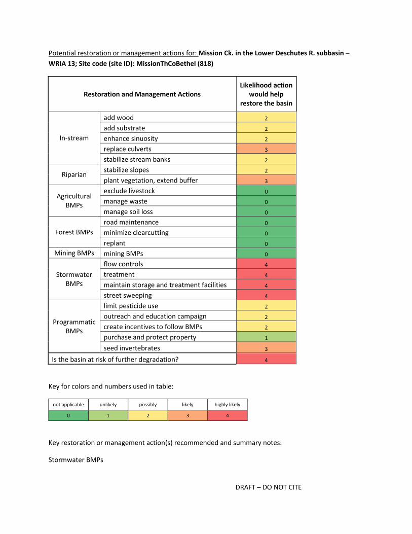
DRAFT – DO NOT CITE
Potential restoration or management actions for: Mission Ck. in the Lower Deschutes R. subbasin –
WRIA 13; Site code (site ID): MissionThCoBethel (818)
Restoration and Management Actions Likelihood action
would help restore the basin
In-stream
add wood 2
add substrate 2
enhance sinuosity 2
replace culverts 3
stabilize stream banks 2
Riparian stabilize slopes 2
plant vegetation, extend buffer 3
Agricultural BMPs
exclude livestock 0
manage waste 0
manage soil loss 0
Forest BMPs
road maintenance 0
minimize clearcutting 0
replant 0
Mining BMPs mining BMPs 0
Stormwater BMPs
flow controls 4
treatment 4
maintain storage and treatment facilities 4
street sweeping 4
Programmatic BMPs
limit pesticide use 2
outreach and education campaign 2
create incentives to follow BMPs 2
purchase and protect property 1
seed invertebrates 3
Is the basin at risk of further degradation? 4
Key for colors and numbers used in table:
not applicable unlikely possibly likely highly likely
0 1 2 3 4
Key restoration or management action(s) recommended and summary notes:
Stormwater BMPs

DRAFT – DO NOT CITE
The Mission Creek basin is zoned primarily for urban residential and is highly developed. The BIBI score
is relatively high given the extent of urbanization in the basin; the biopotential score of 3.2 indicates it is
already scoring within the top ten percent of basins with similar proportions of urban development.
Likewise, the PSWC process analysis indicates the BIBI scores are higher than expected given the
degraded water quality and flow processes. The creek flows through Mission Creek Park, which provides
a wooded area and buffer. This helps explain the relatively high BIBI score given the rest of the land use
in the basin. A small lake, Setchfield Lake, is located within the basin and is surrounded by undeveloped
parcels. Though the lake and creek do not appear to be connected at the surface, there may be some
sub-surface connections that are important in moderating flows. Many of the homes in the
southwestern portion of the basin were built prior to 1955, which is when the City Of Olympia started
requiring new development to have separate stormwater and sanitary conveyance systems. If these
older homes are still largely serviced by combined systems and roof gutters are connected to the
sanitary lines, there may be less hydrologic stress due to stormwater runoff than would be expected
given the extent of impervious surface in the basin. Stormwater BMPs that target runoff from streets,
newer development, and re-development would likely be important in both maintaining the stream
community and creating conditions that would allow BIBI scores to improve. Seeding may also be
appropriate, as there are no nearby or connected sources of diverse taxa.

DRAFT – DO NOT CITE
Artondale Ck. in the Carr Inlet subbasin – WRIA 15; Site code (site ID): BiBi-001 - Artondale Creek (86)
Year 19
99
20
00
20
01
20
02
20
03
20
04
20
05
20
06
20
07
20
08
20
09
20
10
20
11
20
12
20
13
20
14 1999-
2012 Median
B-IBI 30 32 26 32 26 30 28 28 28 30
Basin area (acres)
% urban within basin 1-km of site
% urban in whole basin
% pasture in whole basin
% natural in 90-m buffer
in whole basin
% impervious in 2011 in
whole basin
1644.2 16.74% 14.34% 0.05% 80.86% 7.58%
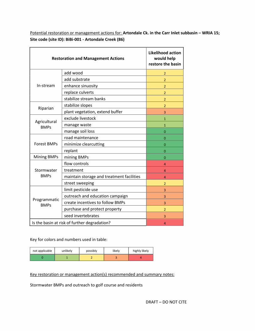
DRAFT – DO NOT CITE
Potential restoration or management actions for: Artondale Ck. in the Carr Inlet subbasin – WRIA 15;
Site code (site ID): BiBi-001 - Artondale Creek (86)
Restoration and Management Actions Likelihood action
would help restore the basin
In-stream
add wood 2
add substrate 2
enhance sinuosity 2
replace culverts 2
stabilize stream banks 2
Riparian stabilize slopes 2
plant vegetation, extend buffer 3
Agricultural BMPs
exclude livestock 1
manage waste 1
manage soil loss 0
Forest BMPs
road maintenance 0
minimize clearcutting 0
replant 0
Mining BMPs mining BMPs 0
Stormwater BMPs
flow controls 4
treatment 4
maintain storage and treatment facilities 4
street sweeping 2
Programmatic BMPs
limit pesticide use 3
outreach and education campaign 3
create incentives to follow BMPs 3
purchase and protect property 2
seed invertebrates 3
Is the basin at risk of further degradation? 4
Key for colors and numbers used in table:
not applicable unlikely possibly likely highly likely
0 1 2 3 4
Key restoration or management action(s) recommended and summary notes:
Stormwater BMPs and outreach to golf course and residents

DRAFT – DO NOT CITE
The Artondale Creek basin currently has variety of land uses although it is zoned almost exclusively for
rural and urban residential. Much of the area zoned for urban residential has not yet been developed,
but the rate of increase in impervious surfaces and the presence of high density, newer developments
may indicate further development is likely. It is clear there are some stormwater BMPs in areas with
new development (e.g., off 62nd Street NW), but areas in the southern portion of the watershed have
older developments (1970s) and may benefit from added or improved stormwater infrastructure. The
stream also flows through a golf course within 1 km of the BIBI site, and there is little to no buffer
adjacent to the stream. There is no clear source of diverse and sensitive invertebrates nearby or within
the watershed, indicating seeding may be appropriate, especially after restoration actions have
occurred.
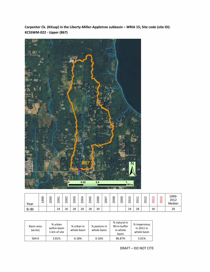
DRAFT – DO NOT CITE
Carpenter Ck. (Kitsap) in the Liberty-Miller-Appletree subbasin – WRIA 15; Site code (site ID):
KCSSWM-022 - Upper (867)
Year 19
99
20
00
20
01
20
02
20
03
20
04
20
05
20
06
20
07
20
08
20
09
20
10
20
11
20
12
20
13
20
14 1999-
2012 Median
B-IBI 24 26 28 28 28 30 24 28 30 28
Basin area (acres)
% urban within basin 1-km of site
% urban in whole basin
% pasture in whole basin
% natural in 90-m buffer
in whole basin
% impervious in 2011 in
whole basin
564.9 3.81% 6.18% 0.16% 86.87% 3.01%

DRAFT – DO NOT CITE
Potential restoration or management actions for: Carpenter Ck. (Kitsap) in the Liberty-Miller-Appletree
subbasin – WRIA 15; Site code (site ID): KCSSWM-022 - Upper (867)
Restoration and Management Actions Likelihood action
would help restore the basin
In-stream
add wood 2
add substrate 2
enhance sinuosity 2
replace culverts 3
stabilize stream banks 2
Riparian stabilize slopes 2
plant vegetation, extend buffer 4
Agricultural BMPs
exclude livestock 3
manage waste 1
manage soil loss 1
Forest BMPs
road maintenance 0
minimize clearcutting 0
replant 0
Mining BMPs mining BMPs 0
Stormwater BMPs
flow controls 4
treatment 4
maintain storage and treatment facilities 3
street sweeping 2
Programmatic BMPs
limit pesticide use 2
outreach and education campaign 3
create incentives to follow BMPs 2
purchase and protect property 2
seed invertebrates 3
Is the basin at risk of further degradation? 4
Key for colors and numbers used in table:
not applicable unlikely possibly likely highly likely
0 1 2 3 4
Key restoration or management action(s) recommended and summary notes:
Stormwater BMPs, small-scale agriculture BMPs

DRAFT – DO NOT CITE
The Carpenter Creek basin is zoned exclusively for rural residential and many lots near the stream have
been partially cleared for small-scale agriculture (hobby farms). The homes within the basin range in
age, but many appear to have been built before the 1990s and likely do not have any stormwater BMPs.
The creek follows a road for much of its length, and therefore stormwater BMPs to treat road runoff
may also be appropriate. Outreach to landowners to encourage riparian protection and expansion, as
well as prudent pesticide use may be appropriate. Seeding may also be needed given there are no
connected or nearby sources of diverse invertebrates.
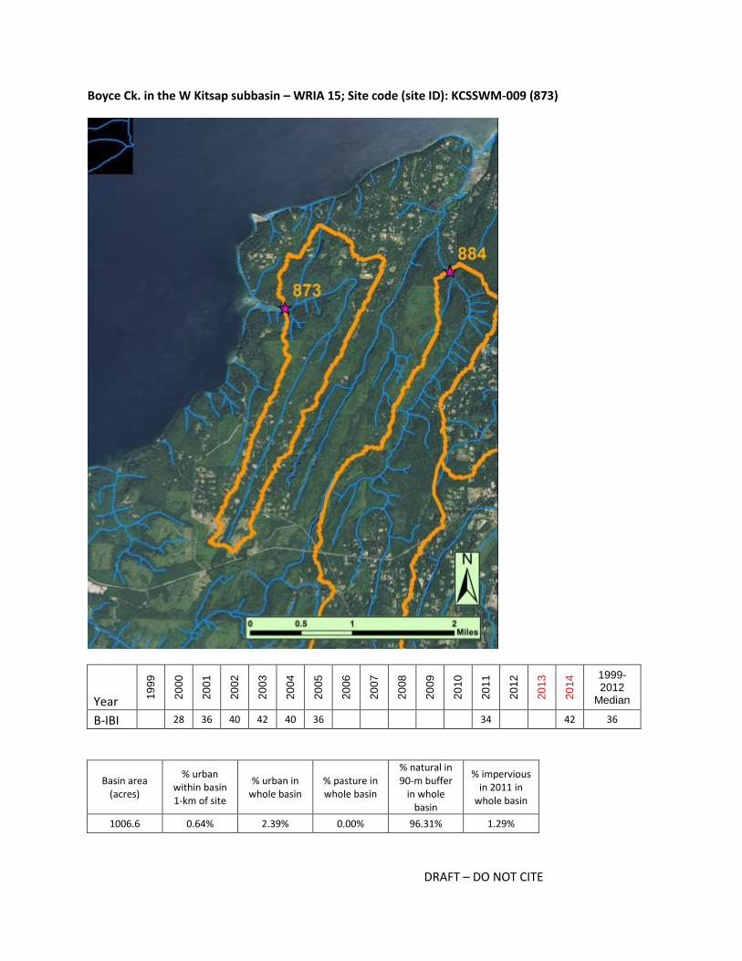
DRAFT – DO NOT CITE
Boyce Ck. in the W Kitsap subbasin – WRIA 15; Site code (site ID): KCSSWM-009 (873)
Year 19
99
20
00
20
01
20
02
20
03
20
04
20
05
20
06
20
07
20
08
20
09
20
10
20
11
20
12
20
13
20
14 1999-
2012 Median
B-IBI 28 36 40 42 40 36 34 42 36
Basin area (acres)
% urban within basin 1-km of site
% urban in whole basin
% pasture in whole basin
% natural in 90-m buffer
in whole basin
% impervious in 2011 in
whole basin
1006.6 0.64% 2.39% 0.00% 96.31% 1.29%

DRAFT – DO NOT CITE
Potential restoration or management actions for: Boyce Ck. in the W Kitsap subbasin – WRIA 15; Site
code (site ID): KCSSWM-009 (873)
Restoration and Management Actions Likelihood action
would help restore the basin
In-stream
add wood 2
add substrate 2
enhance sinuosity 2
replace culverts 2
stabilize stream banks 2
Riparian stabilize slopes 2
plant vegetation, extend buffer 2
Agricultural BMPs
exclude livestock 0
manage waste 0
manage soil loss 0
Forest BMPs
road maintenance 0
minimize clearcutting 0
replant 0
Mining BMPs mining BMPs 0
Stormwater BMPs
flow controls 3
treatment 3
maintain storage and treatment facilities 2
street sweeping 2
Programmatic BMPs
limit pesticide use 2
outreach and education campaign 2
create incentives to follow BMPs 2
purchase and protect property 3
seed invertebrates 1
Is the basin at risk of further degradation? 4
Key for colors and numbers used in table:
not applicable unlikely possibly likely highly likely
0 1 2 3 4
Key restoration or management action(s) recommended and summary notes:
Protect current conditions, stormwater BMPs

DRAFT – DO NOT CITE
The Boyce Creek basin is zoned exclusively for rural residential though most of the lower half has not
been developed. The BIBI site is within the Guillemot Cove Nature Reserve, and the score in 2014 was 42
(excellent). There are likely restoration actions that could be implemented to help protect the conditions
at the site. This could include stormwater BMPs designed to help control flow and water quality from
runoff in the upper basin, where there are some older homes. That said, the focus should be on
protecting the current conditions so the diverse community present in 2014 can persist.

DRAFT – DO NOT CITE
Gamble Ck. in the Bangor-Port Gamble subbasin – WRIA 15; Site code (site ID): KCST-7 (876)
Year 19
99
20
00
20
01
20
02
20
03
20
04
20
05
20
06
20
07
20
08
20
09
20
10
20
11
20
12
20
13
20
14 1999-
2012 Median
B-IBI 26 34 34 34 30 34
Basin area (acres)
% urban within basin 1-km of site
% urban in whole basin
% pasture in whole basin
% natural in 90-m buffer
in whole basin
% impervious in 2011 in
whole basin
1483.4 9.15% 10.17% 3.48% 82.02% 4.14%

DRAFT – DO NOT CITE
Potential restoration or management actions for: Gamble Ck. in the Bangor-Port Gamble subbasin –
WRIA 15; Site code (site ID): KCST-7 (876)
Restoration and Management Actions Likelihood action
would help restore the basin
In-stream
add wood 2
add substrate 2
enhance sinuosity 2
replace culverts 2
stabilize stream banks 2
Riparian stabilize slopes 2
plant vegetation, extend buffer 4
Agricultural BMPs
exclude livestock 4
manage waste 2
manage soil loss 2
Forest BMPs
road maintenance 0
minimize clearcutting 0
replant 0
Mining BMPs mining BMPs 0
Stormwater BMPs
flow controls 4
treatment 4
maintain storage and treatment facilities 4
street sweeping 1
Programmatic BMPs
limit pesticide use 3
outreach and education campaign 4
create incentives to follow BMPs 3
purchase and protect property 2
seed invertebrates 2
Is the basin at risk of further degradation? 4
Key for colors and numbers used in table:
not applicable unlikely possibly likely highly likely
0 1 2 3 4
Key restoration or management action(s) recommended and summary notes:
Agricultural and stormwater BMPs, outreach, widening buffer
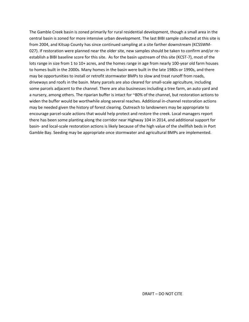
DRAFT – DO NOT CITE
The Gamble Creek basin is zoned primarily for rural residential development, though a small area in the
central basin is zoned for more intensive urban development. The last BIBI sample collected at this site is
from 2004, and Kitsap County has since continued sampling at a site farther downstream (KCSSWM-
027). If restoration were planned near the older site, new samples should be taken to confirm and/or re-
establish a BIBI baseline score for this site. As for the basin upstream of this site (KCST-7), most of the
lots range in size from 1 to 10+ acres, and the homes range in age from nearly 100-year old farm houses
to homes built in the 2000s. Many homes in the basin were built in the late 1980s or 1990s, and there
may be opportunities to install or retrofit stormwater BMPs to slow and treat runoff from roads,
driveways and roofs in the basin. Many parcels are also cleared for small-scale agriculture, including
some parcels adjacent to the channel. There are also businesses including a tree farm, an auto yard and
a nursery, among others. The riparian buffer is intact for ~80% of the channel, but restoration actions to
widen the buffer would be worthwhile along several reaches. Additional in-channel restoration actions
may be needed given the history of forest clearing. Outreach to landowners may be appropriate to
encourage parcel-scale actions that would help protect and restore the creek. Local managers report
there has been some planting along the corridor near Highway 104 in 2014, and additional support for
basin- and local-scale restoration actions is likely because of the high value of the shellfish beds in Port
Gamble Bay. Seeding may be appropriate once stormwater and agricultural BMPs are implemented.
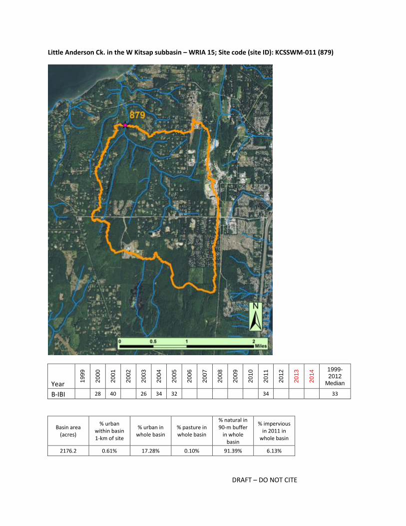
DRAFT – DO NOT CITE
Little Anderson Ck. in the W Kitsap subbasin – WRIA 15; Site code (site ID): KCSSWM-011 (879)
Year 19
99
20
00
20
01
20
02
20
03
20
04
20
05
20
06
20
07
20
08
20
09
20
10
20
11
20
12
20
13
20
14 1999-
2012 Median
B-IBI 28 40 26 34 32 34 33
Basin area (acres)
% urban within basin 1-km of site
% urban in whole basin
% pasture in whole basin
% natural in 90-m buffer
in whole basin
% impervious in 2011 in
whole basin
2176.2 0.61% 17.28% 0.10% 91.39% 6.13%

DRAFT – DO NOT CITE
Potential restoration or management actions for: Little Anderson Ck. in the W Kitsap subbasin – WRIA
15; Site code (site ID): KCSSWM-011 (879)
Restoration and Management Actions Likelihood action
would help restore the basin
In-stream
add wood 2
add substrate 2
enhance sinuosity 2
replace culverts 2
stabilize stream banks 2
Riparian stabilize slopes 2
plant vegetation, extend buffer 2
Agricultural BMPs
exclude livestock 1
manage waste 1
manage soil loss 0
Forest BMPs
road maintenance 0
minimize clearcutting 0
replant 0
Mining BMPs mining BMPs 2
Stormwater BMPs
flow controls 4
treatment 4
maintain storage and treatment facilities 4
street sweeping 3
Programmatic BMPs
limit pesticide use 3
outreach and education campaign 4
create incentives to follow BMPs 3
purchase and protect property 2
seed invertebrates 3
Is the basin at risk of further degradation? 4
Key for colors and numbers used in table:
not applicable unlikely possibly likely highly likely
0 1 2 3 4
Key restoration or management action(s) recommended and summary notes:
Stormwater BMPs, outreach

DRAFT – DO NOT CITE
The Little Anderson Creek is zoned primarily for rural residential though over 20% of the basin is zoned
for urban residential, commercial and/or industrial. Much of the lower 1-km basin is forested, especially
near the creek channel. However, local managers report the basin is at risk for development, and photos
suggest there could be additional rural residential development in the lower basin and denser
development in the eastern part of the basin. Stormwater ponds have been included in areas with new
developments, but additional stormwater BMPs may be beneficial in areas built prior to the most recent
stormwater regulations. The eastern edge of the basin is zoned for military use, and there appears to be
a large mine or gravel yard there. Containing and/or treating flows from this area is important for
protecting water quality within the creek. There is a small portion of the upper basin protected in the
Newberry Hill Heritage Park and it is reported that retrofits are planned near the park. Outreach to
homeowners encouraging low-impact yard care and other protective activities may be worthwhile. Once
stormwater BMPs are installed, seeding may be appropriate given there are few nearby sources of
diverse and sensitive taxa.

DRAFT – DO NOT CITE
Little Boston in the Bangor-Port Gamble subbasin – WRIA 15; Site code (site ID): KCSSWM-031 (880)
Year 19
99
20
00
20
01
20
02
20
03
20
04
20
05
20
06
20
07
20
08
20
09
20
10
20
11
20
12
20
13
20
14 1999-
2012 Median
B-IBI 34 36 24 32 32 26 24 32
Basin area (acres)
% urban within basin 1-km of site
% urban in whole basin
% pasture in whole basin
% natural in 90-m buffer
in whole basin
% impervious in 2011 in
whole basin
602.8 8.45% 3.91% 0.00% 95.99% 1.09%

DRAFT – DO NOT CITE
Potential restoration or management actions for: Little Boston in the Bangor-Port Gamble subbasin –
WRIA 15; Site code (site ID): KCSSWM-031 (880)
Restoration and Management Actions Likelihood action
would help restore the basin
In-stream
add wood 2
add substrate 2
enhance sinuosity 2
replace culverts 2
stabilize stream banks 2
Riparian stabilize slopes 2
plant vegetation, extend buffer 2
Agricultural BMPs
exclude livestock 0
manage waste 0
manage soil loss 0
Forest BMPs
road maintenance 2
minimize clearcutting 4
replant 2
Mining BMPs mining BMPs 0
Stormwater BMPs
flow controls 1
treatment 1
maintain storage and treatment facilities 1
street sweeping 1
Programmatic BMPs
limit pesticide use 2
outreach and education campaign 2
create incentives to follow BMPs 2
purchase and protect property 1
seed invertebrates 3
Is the basin at risk of further degradation? 2
Key for colors and numbers used in table:
not applicable unlikely possibly likely highly likely
0 1 2 3 4
Key restoration or management action(s) recommended and summary notes:
Forest BMPs, seeding

DRAFT – DO NOT CITE
Little Boston Creek flows through the Port Gamble Reservation for most of its length, and land that is
not within the reservation is primarily zoned as rural residential. The forest upstream of the site is
largely intact, though based on the crown size seen in photos, the trees appear relatively young.
Previous logging may have had lasting impacts on the creek, but unlike most basins in the Puget Sound,
this is a lowland creek that is likely not affected by stormwater runoff. If habitat conditions have not
recovered naturally from the effects of past logging, in-channel restoration actions may be appropriate.
There are no nearby or connected sources of diverse and sensitive invertebrates; therefore, if in-channel
habitat conditions appear suitable, it is likely worthwhile to try seeding before doing more expensive
actions.
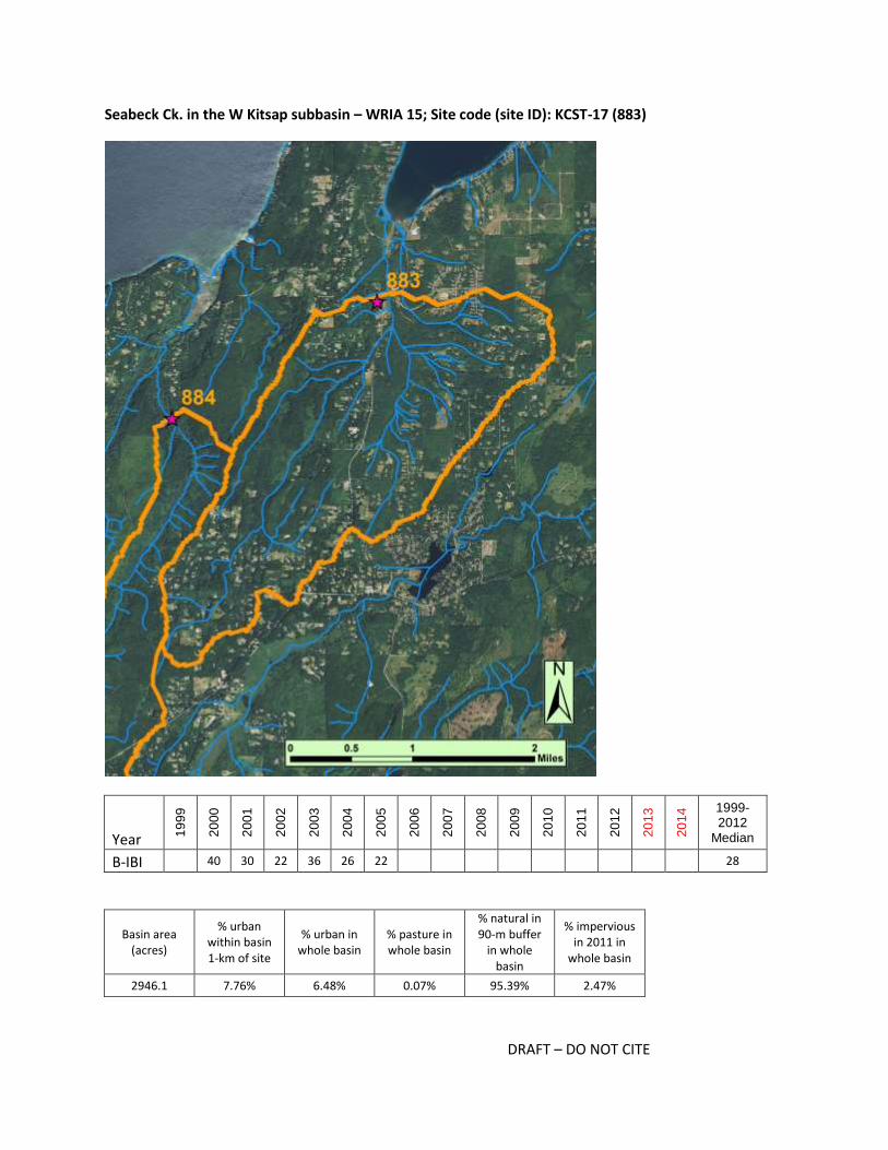
DRAFT – DO NOT CITE
Seabeck Ck. in the W Kitsap subbasin – WRIA 15; Site code (site ID): KCST-17 (883)
Year 19
99
20
00
20
01
20
02
20
03
20
04
20
05
20
06
20
07
20
08
20
09
20
10
20
11
20
12
20
13
20
14 1999-
2012 Median
B-IBI 40 30 22 36 26 22 28
Basin area (acres)
% urban within basin 1-km of site
% urban in whole basin
% pasture in whole basin
% natural in 90-m buffer
in whole basin
% impervious in 2011 in
whole basin
2946.1 7.76% 6.48% 0.07% 95.39% 2.47%

DRAFT – DO NOT CITE
Potential restoration or management actions for: Seabeck Ck. in the W Kitsap subbasin – WRIA 15; Site
code (site ID): KCST-17 (883)
Restoration and Management Actions Likelihood action
would help restore the basin
In-stream
add wood 2
add substrate 2
enhance sinuosity 1
replace culverts 2
stabilize stream banks 2
Riparian stabilize slopes 2
plant vegetation, extend buffer 2
Agricultural BMPs
exclude livestock 0
manage waste 0
manage soil loss 0
Forest BMPs
road maintenance 0
minimize clearcutting 0
replant 0
Mining BMPs mining BMPs 0
Stormwater BMPs
flow controls 3
treatment 3
maintain storage and treatment facilities 3
street sweeping 2
Programmatic BMPs
limit pesticide use 2
outreach and education campaign 2
create incentives to follow BMPs 2
purchase and protect property 2
seed invertebrates 3
Is the basin at risk of further degradation? 4
Key for colors and numbers used in table:
not applicable unlikely possibly likely highly likely
0 1 2 3 4
Key restoration or management action(s) recommended and summary notes:
Protect existing riparian areas, seeding, possibly install stormwater BMPs

DRAFT – DO NOT CITE
The Seabeck Creek basin is zoned entirely for rural residential, although there is a small area in the
western part of the basin that is protected in the Stavis Natural Resources Conservation Area. Kitsap
County is working on stormwater retrofits downstream of the BIBI site, but additional stormwater BMPs
and/or retrofits upstream of the BIBI site would presumably help restore surface storage and discharge
processes for this basin as well as the larger basin. If reach-scale habitat conditions appear good,
seeding would be recommended as there are no nearby sources of diverse invertebrates. If habitat
conditions are poor, in-channel actions may be needed but those should be implemented after basin-
scale flow processes have been restored. Protecting the channel and riparian zone from the impacts of
further development should be prioritized.

DRAFT – DO NOT CITE
Stavis Ck. in the W Kitsap subbasin – WRIA 15; Site code (site ID): KCST-16 (884)
Year 19
99
20
00
20
01
20
02
20
03
20
04
20
05
20
06
20
07
20
08
20
09
20
10
20
11
20
12
20
13
20
14 1999-
2012 Median
B-IBI 24 32 28 24 40 28
Basin area (acres)
% urban within basin 1-km of site
% urban in whole basin
% pasture in whole basin
% natural in 90-m buffer
in whole basin
% impervious in 2011 in
whole basin
1931.5 0.00% 2.92% 0.00% 97.80% 1.38%

DRAFT – DO NOT CITE
Potential restoration or management actions for: Stavis Ck. in the W Kitsap subbasin – WRIA 15; Site
code (site ID): KCST-16 (884)
Restoration and Management Actions Likelihood action
would help restore the basin
In-stream
add wood 3
add substrate 2
enhance sinuosity 1
replace culverts 1
stabilize stream banks 1
Riparian stabilize slopes 1
plant vegetation, extend buffer 1
Agricultural BMPs
exclude livestock 0
manage waste 0
manage soil loss 0
Forest BMPs
road maintenance 0
minimize clearcutting 0
replant 0
Mining BMPs mining BMPs 0
Stormwater BMPs
flow controls 2
treatment 2
maintain storage and treatment facilities 2
street sweeping 2
Programmatic BMPs
limit pesticide use 2
outreach and education campaign 2
create incentives to follow BMPs 2
purchase and protect property 2
seed invertebrates 2
Is the basin at risk of further degradation? 4
Key for colors and numbers used in table:
not applicable unlikely possibly likely highly likely
0 1 2 3 4
Key restoration or management action(s) recommended and summary notes:
Possible in-channel habitat restoration

DRAFT – DO NOT CITE
The Stavis Creek basin is zoned exclusively for rural residential, though it appears most of the housing is
in the upper basin, and few if any homes have been built near the creek. Large intact patches of forest
are present, and the buffer appears wide and intact for most of the creek length. BIBI scores at sites
along this creek vary considerably, and before restoration plans are developed, BIBI samples should be
collected at multiple points along the creek. This is needed to establish a more recent assessment (the
last sample at this site was collected in 2004), but also to determine if the variability is as great as
previous samples would suggest. Scores at site #884 ranged from 24 to 40 over 5 years. A site
approximately 1.5 km upstream of #884 was sampled once in 2000 with a score of 44. In contrast, a site
less than 1 km downstream of #884 scored 16 and 24 in 2011 and 2013, respectively. If sites upstream
of site #884 score good or excellent, protecting the upper basin from further development should be a
high priority. Restoring in-channel conditions may be appropriate if legacy effects of logging persist.
Land upstream of the site is designated as a DNR conservation area, and restoration in this area may be
a good starting point. If scores are still highly variable along the creek, additional work may be needed to
identify the cause of the variation before restoration actions could be recommended.

DRAFT – DO NOT CITE
Ray Nash Ck. in the Carr Inlet subbasin – WRIA 15; Site code (site ID): BiBi-025 - Ray Nash Creek (896)
Year 19
99
20
00
20
01
20
02
20
03
20
04
20
05
20
06
20
07
20
08
20
09
20
10
20
11
20
12
20
13
20
14 1999-
2012 Median
B-IBI 24 34 26 34 28 28 30 28
Basin area (acres)
% urban within basin 1-km of site
% urban in whole basin
% pasture in whole basin
% natural in 90-m buffer
in whole basin
% impervious in 2011 in
whole basin
1391.5 7.33% 13.50% 2.59% 77.47% 6.90%

DRAFT – DO NOT CITE
Potential restoration or management actions for: Ray Nash Ck. in the Carr Inlet subbasin – WRIA 15;
Site code (site ID): BiBi-025 - Ray Nash Creek (896)
Restoration and Management Actions Likelihood action
would help restore the basin
In-stream
add wood 2
add substrate 2
enhance sinuosity 2
replace culverts 2
stabilize stream banks 2
Riparian stabilize slopes 2
plant vegetation, extend buffer 4
Agricultural BMPs
exclude livestock 2
manage waste 2
manage soil loss 1
Forest BMPs
road maintenance 0
minimize clearcutting 0
replant 0
Mining BMPs mining BMPs 0
Stormwater BMPs
flow controls 4
treatment 4
maintain storage and treatment facilities 4
street sweeping 1
Programmatic BMPs
limit pesticide use 3
outreach and education campaign 3
create incentives to follow BMPs 2
purchase and protect property 3
seed invertebrates 3
Is the basin at risk of further degradation? 4
Key for colors and numbers used in table:
not applicable unlikely possibly likely highly likely
0 1 2 3 4
Key restoration or management action(s) recommended and summary notes:
Stormwater BMPs throughout and agricultural BMPs in southern part of the basin, extend and/or plant
buffer, outreach and other programmatic BMPs

DRAFT – DO NOT CITE
Fifty-one percent of the Ray Nash Creek basin is zoned for urban residential, with most of that along the
stream corridor. Despite this zoning, the current density of homes is relatively low. Stormwater BMPs
may be recommended given that many homes were built prior to 1990. Most of the remaining basin
(48%) is zoned rural residential, and this land is distributed along the edges of the basin. A large portion
of the southern tributary appears to flow through several pastures and the stream channel appears to
have little to no buffer. General agricultural BMPs, and especially ones that establish and protect
riparian areas would be recommended. The PSWC analysis indicated most water flow and water quality
processes have been degraded across the basin, suggesting stormwater and agricultural BMPs across
the basin may be needed. However, protecting current conditions may be more important given most of
the area zoned for high density development is not yet developed. In-channel restoration may also be
needed, but assessing this will require a site visit and would likely be most appropriate only after current
and anticipated basin-scale stressors have been addressed.

DRAFT – DO NOT CITE
Purdy Ck. (Burley Lagoon) in the Carr Inlet subbasin – WRIA 15; Site code (site ID): BiBi-028 - Purdy
Creek (908)
Year 19
99
20
00
20
01
20
02
20
03
20
04
20
05
20
06
20
07
20
08
20
09
20
10
20
11
20
12
20
13
20
14 1999-
2012 Median
B-IBI 30 36 26 30 32 30
Basin area (acres)
% urban within basin 1-km of site
% urban in whole basin
% pasture in whole basin
% natural in 90-m buffer
in whole basin
% impervious in 2011 in
whole basin
2314.2 25.38% 8.45% 0.44% 90.33% 4.38%

DRAFT – DO NOT CITE
Potential restoration or management actions for: Purdy Ck. (Burley Lagoon) in the Carr Inlet subbasin –
WRIA 15; Site code (site ID): BiBi-028 - Purdy Creek (908)
Restoration and Management Actions Likelihood action
would help restore the basin
In-stream
add wood 2
add substrate 2
enhance sinuosity 2
replace culverts 2
stabilize stream banks 2
Riparian stabilize slopes 2
plant vegetation, extend buffer 2
Agricultural BMPs
exclude livestock 0
manage waste 0
manage soil loss 0
Forest BMPs
road maintenance 0
minimize clearcutting 0
replant 0
Mining BMPs mining BMPs 0
Stormwater BMPs
flow controls 3
treatment 3
maintain storage and treatment facilities 3
street sweeping 1
Programmatic BMPs
limit pesticide use 3
outreach and education campaign 3
create incentives to follow BMPs 2
purchase and protect property 2
seed invertebrates 3
Is the basin at risk of further degradation? 4
Key for colors and numbers used in table:
not applicable unlikely possibly likely highly likely
0 1 2 3 4
Key restoration or management action(s) recommended and summary notes:
Stormwater BMPs

DRAFT – DO NOT CITE
The Purdy Creek basin is similar to other basins on the Kitsap Peninsula in that it is zoned primarily for
rural residential use, and it may not yet be developed to that capacity. There appears to be a large area
of intact forest in the lower basin, within 2 km of the BIBI site; however, much of this area is zoned for
urban residential, suggesting the amount of impervious payment in this lower basin may increase
dramatically in the future. The homes currently in the basin appear to have been built in the 1990s or
2000s, suggesting some stormwater BMPs may have been installed. Additional stormwater BMPs may
be appropriate, especially along Rt 16 and other roadways. Outreach to landowners may be
advantageous, as there are several parcels with cleared areas near the creek. Seeding may also be
appropriate, as there are few nearby sources of diverse invertebrates. A site visit would be needed to
assess whether in-channel restoration would be recommended.

DRAFT – DO NOT CITE
Herron Ck. in the Key Peninsula subbasin – WRIA 15; Site code (site ID): BiBi-034 - Herron Creek (1100)
Year 19
99
20
00
20
01
20
02
20
03
20
04
20
05
20
06
20
07
20
08
20
09
20
10
20
11
20
12
20
13
20
14 1999-
2012 Median
B-IBI 30 30 34 22 30
Basin area (acres)
% urban within basin 1-km of site
% urban in whole basin
% pasture in whole basin
% natural in 90-m buffer
in whole basin
% impervious in 2011 in
whole basin
642.9 1.97% 2.73% 0.00% 99.48% 0.99%

DRAFT – DO NOT CITE
Potential restoration or management actions for: Herron Ck. in the Key Peninsula subbasin – WRIA 15;
Site code (site ID): BiBi-034 - Herron Creek (1100)
Restoration and Management Actions Likelihood action
would help restore the basin
In-stream
add wood 2
add substrate 2
enhance sinuosity 2
replace culverts 2
stabilize stream banks 2
Riparian stabilize slopes 1
plant vegetation, extend buffer 1
Agricultural BMPs
exclude livestock 0
manage waste 0
manage soil loss 0
Forest BMPs
road maintenance 0
minimize clearcutting 0
replant 0
Mining BMPs mining BMPs 0
Stormwater BMPs
flow controls 4
treatment 4
maintain storage and treatment facilities 3
street sweeping 1
Programmatic BMPs
limit pesticide use 2
outreach and education campaign 3
create incentives to follow BMPs 3
purchase and protect property 2
seed invertebrates 3
Is the basin at risk of further degradation? 4
Key for colors and numbers used in table:
not applicable unlikely possibly likely highly likely
0 1 2 3 4
Key restoration or management action(s) recommended and summary notes:
Stormwater BMPs

DRAFT – DO NOT CITE
The Herron Creek basin is zoned primarily for rural residential use, but nearly a third of the area in the
stream corridor is zoned for urban residential. Currently, most homes in this corridor are on 5-acre
parcels and there appear to be large patches of intact or partially thinned forest. Photos from 2013
suggest there are no immediate developments planned (e.g., no recently graded lots or new roads).
Installing stormwater BMPs to address surface storage and discharge processes associated with previous
development may be beneficial. Given current land use, the BIBI scores are rather low (Biopotential
score of -9.7). If a site visit reveals local conditions are good, seeding may be an appropriate action. If
local conditions are poor, in-channel restoration may be needed, but this should be undertaken only if
further development is not anticipated. Outreach to homeowners with properties on the creek may
also be helpful.

DRAFT – DO NOT CITE
Barker Ck. in the Dyes Inlet / Central Kitsap subbasin – WRIA 15; Site code (site ID): KCSSWM-001 -
Lower (1270)
Year 19
99
20
00
20
01
20
02
20
03
20
04
20
05
20
06
20
07
20
08
20
09
20
10
20
11
20
12
20
13
20
14 1999-
2012 Median
B-IBI 30 24 28 30 28
Basin area (acres)
% urban within basin 1-km of site
% urban in whole basin
% pasture in whole basin
% natural in 90-m buffer
in whole basin
% impervious in 2011 in
whole basin
2512.6 38.91% 33.38% 0.89% 62.15% 16.38%
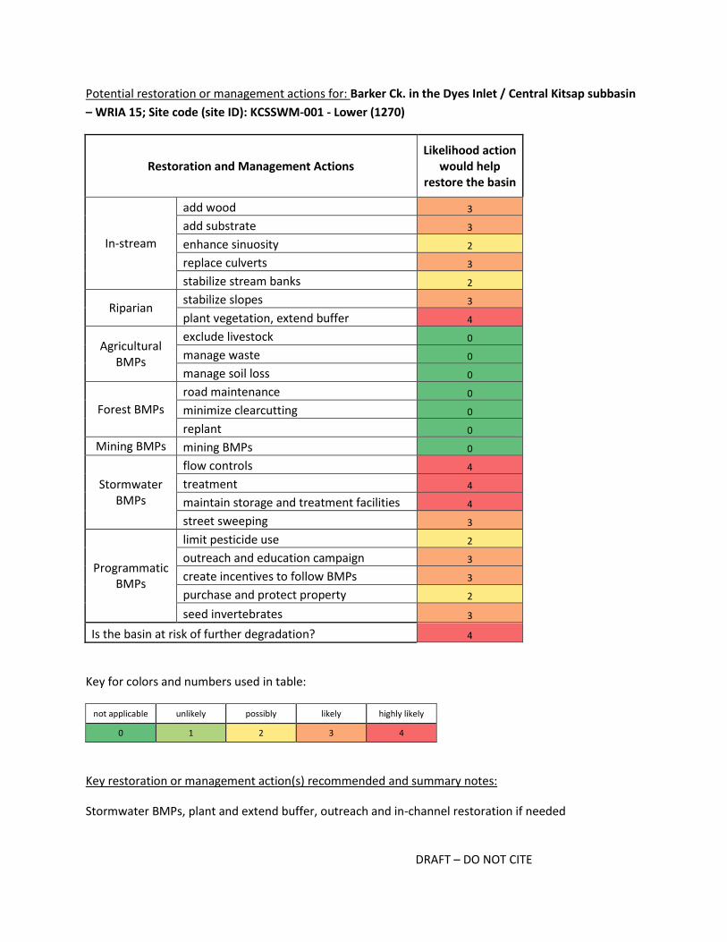
DRAFT – DO NOT CITE
Potential restoration or management actions for: Barker Ck. in the Dyes Inlet / Central Kitsap subbasin
– WRIA 15; Site code (site ID): KCSSWM-001 - Lower (1270)
Restoration and Management Actions Likelihood action
would help restore the basin
In-stream
add wood 3
add substrate 3
enhance sinuosity 2
replace culverts 3
stabilize stream banks 2
Riparian stabilize slopes 3
plant vegetation, extend buffer 4
Agricultural BMPs
exclude livestock 0
manage waste 0
manage soil loss 0
Forest BMPs
road maintenance 0
minimize clearcutting 0
replant 0
Mining BMPs mining BMPs 0
Stormwater BMPs
flow controls 4
treatment 4
maintain storage and treatment facilities 4
street sweeping 3
Programmatic BMPs
limit pesticide use 2
outreach and education campaign 3
create incentives to follow BMPs 3
purchase and protect property 2
seed invertebrates 3
Is the basin at risk of further degradation? 4
Key for colors and numbers used in table:
not applicable unlikely possibly likely highly likely
0 1 2 3 4
Key restoration or management action(s) recommended and summary notes:
Stormwater BMPs, plant and extend buffer, outreach and in-channel restoration if needed

DRAFT – DO NOT CITE
Stormwater retrofits are currently being planned and implemented in the Barker Creek basin. Kitsap
County reports that there is a lot of work taking place to protect corridor and manage stormwater, for
instance green streets have been added along Fairwood Avenue and twenty stormwater ponds in the
basin will be retrofitted. The BIBI site will be sampled every year which will provide a consistent and
reliable indicator for measuring restoration effectiveness as these BMPs are implemented. In addition,
in-channel restoration actions may be worthwhile given the likelihood that hydrologic factors have
affected habitat conditions and BMPs may help reduce those impacts. Outreach to homeowners may
provide a way to explain the current actions and encourage individual action to help protect the stream.
Seeding may also be appropriate given there are no connected or nearby sources of diverse and
sensitive invertebrate taxa.

DRAFT – DO NOT CITE
Mosher Ck. in the Dyes Inlet / Central Kitsap subbasin – WRIA 15; Site code (site ID): KCSSWM-012
(1288)
Year 19
99
20
00
20
01
20
02
20
03
20
04
20
05
20
06
20
07
20
08
20
09
20
10
20
11
20
12
20
13
20
14 1999-
2012 Median
B-IBI 38 26 30 30 30
Basin area (acres)
% urban within basin 1-km of site
% urban in whole basin
% pasture in whole basin
% natural in 90-m buffer
in whole basin
% impervious in 2011 in
whole basin
1051.9 26.76% 51.40% 0.02% 53.24% 25.06%

DRAFT – DO NOT CITE
Potential restoration or management actions for: Mosher Ck. in the Dyes Inlet / Central Kitsap subbasin
– WRIA 15; Site code (site ID): KCSSWM-012 (1288)
Restoration and Management Actions Likelihood action
would help restore the basin
In-stream
add wood 2
add substrate 2
enhance sinuosity 2
replace culverts 2
stabilize stream banks 2
Riparian stabilize slopes 2
plant vegetation, extend buffer 4
Agricultural BMPs
exclude livestock 1
manage waste 1
manage soil loss 1
Forest BMPs
road maintenance 0
minimize clearcutting 0
replant 0
Mining BMPs mining BMPs 0
Stormwater BMPs
flow controls 4
treatment 4
maintain storage and treatment facilities 4
street sweeping 1
Programmatic BMPs
limit pesticide use 2
outreach and education campaign 2
create incentives to follow BMPs 2
purchase and protect property 2
seed invertebrates 3
Is the basin at risk of further degradation? 4
Key for colors and numbers used in table:
not applicable unlikely possibly likely highly likely
0 1 2 3 4
Key restoration or management action(s) recommended and summary notes:
Stormwater BMPs, extend and plant buffer

DRAFT – DO NOT CITE
Nearly 80% of the Mosher Creek basin is zoned for urban residential. The invertebrate community is
remarkably diverse given the current land use and rate of development (i.e., the biopotential score of
1.1 indicates it is already scoring in the top 10% of sites with the same % urbanization). Additional
development may be planned; a 29 acre parcel was sold in 2014, and several other large parcels
adjacent to near the stream may be subdivided and developed in the future. There are some detention
ponds near older developments as well as recent retrofits of existing stormwater facilities, but
additional stormwater BMPs are recommended. There does not appear to be a nearby source of diverse
taxa, and therefore seeding may be appropriate.

DRAFT – DO NOT CITE
Parish Ck. in the S Sinclair Inlet subbasin – WRIA 15; Site code (site ID): KCSSWM-018 – (Gorst Trib)
(1290)
Year 19
99
20
00
20
01
20
02
20
03
20
04
20
05
20
06
20
07
20
08
20
09
20
10
20
11
20
12
20
13
20
14 1999-
2012 Median
B-IBI 36 30 32 32 28 32
Basin area (acres)
% urban within basin 1-km of site
% urban in whole basin
% pasture in whole basin
% natural in 90-m buffer
in whole basin
% impervious in 2011 in
whole basin
1128.9 16.29% 13.16% 0.18% 88.75% 5.36%
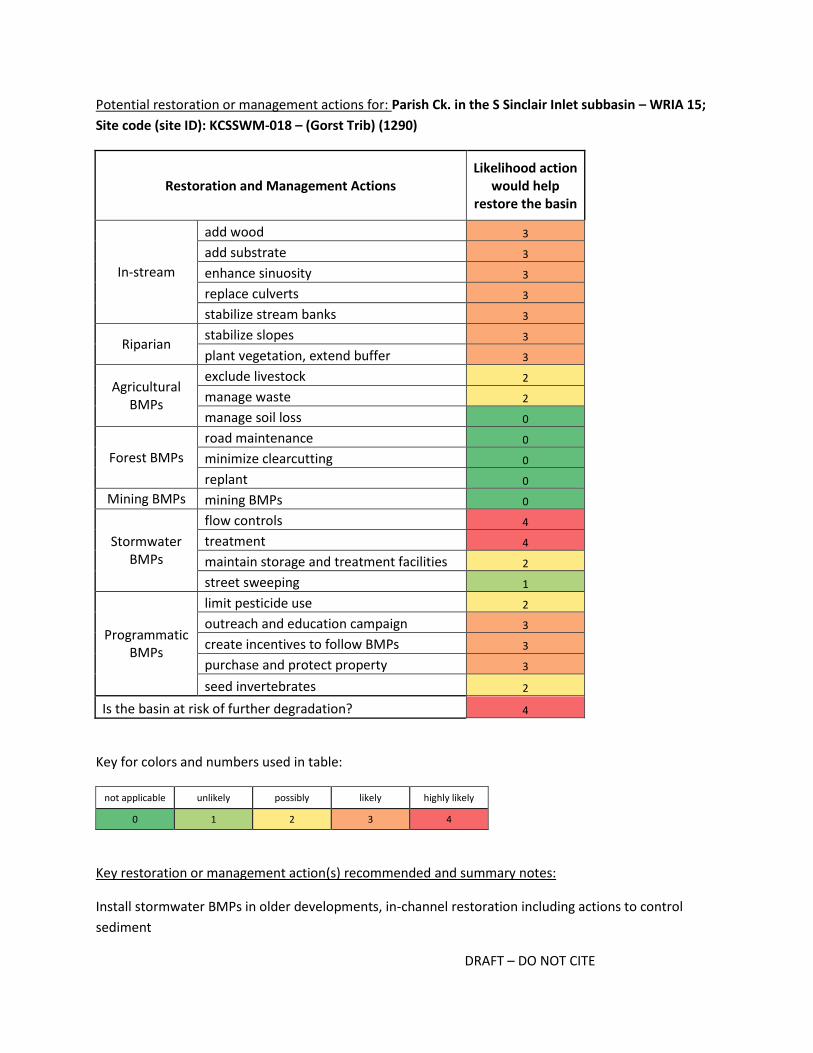
DRAFT – DO NOT CITE
Potential restoration or management actions for: Parish Ck. in the S Sinclair Inlet subbasin – WRIA 15;
Site code (site ID): KCSSWM-018 – (Gorst Trib) (1290)
Restoration and Management Actions Likelihood action
would help restore the basin
In-stream
add wood 3
add substrate 3
enhance sinuosity 3
replace culverts 3
stabilize stream banks 3
Riparian stabilize slopes 3
plant vegetation, extend buffer 3
Agricultural BMPs
exclude livestock 2
manage waste 2
manage soil loss 0
Forest BMPs
road maintenance 0
minimize clearcutting 0
replant 0
Mining BMPs mining BMPs 0
Stormwater BMPs
flow controls 4
treatment 4
maintain storage and treatment facilities 2
street sweeping 1
Programmatic BMPs
limit pesticide use 2
outreach and education campaign 3
create incentives to follow BMPs 3
purchase and protect property 3
seed invertebrates 2
Is the basin at risk of further degradation? 4
Key for colors and numbers used in table:
not applicable unlikely possibly likely highly likely
0 1 2 3 4
Key restoration or management action(s) recommended and summary notes:
Install stormwater BMPs in older developments, in-channel restoration including actions to control
sediment

DRAFT – DO NOT CITE
The Parish Creek basin is zoned primarily for rural residential, though most of the 1-km basin
immediately upstream of the site is zoned for urban residential. Much of the development in the basin
was built in the 1960s and 1970s with no stormwater controls. The urban zone and much of the eastern
portion of the basin have not been developed extensively. In addition to installing stormwater BMPs in
the areas with older homes, any new development should include the most recently required
stormwater BMPs that address flow and water quality processes. Kitsap County staff indicated sediment
may be limiting the invertebrate community, and therefore in addition to basin-scale stormwater BMPs,
actions that target sediment loading and transport may be appropriate. These actions may include
extending riparian buffers, bank stabilization and channel restoration. Kitsap County staff also indicated
the Suquamish Tribe is interested in the basin, and therefore there may be regional interest and support
for restoration actions. Seeding may be appropriate once restoration actions have been implemented,
but there may also be sufficient sources of diverse invertebrates in the nearby basins that have excellent
BIBI scores.
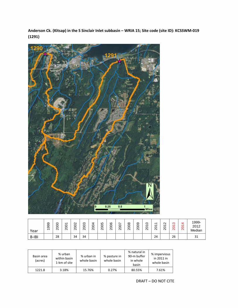
DRAFT – DO NOT CITE
Anderson Ck. (Kitsap) in the S Sinclair Inlet subbasin – WRIA 15; Site code (site ID): KCSSWM-019
(1291)
Year 19
99
20
00
20
01
20
02
20
03
20
04
20
05
20
06
20
07
20
08
20
09
20
10
20
11
20
12
20
13
20
14 1999-
2012 Median
B-IBI 28 34 34 24 26 31
Basin area (acres)
% urban within basin 1-km of site
% urban in whole basin
% pasture in whole basin
% natural in 90-m buffer
in whole basin
% impervious in 2011 in
whole basin
1221.8 3.18% 15.76% 0.27% 80.55% 7.61%
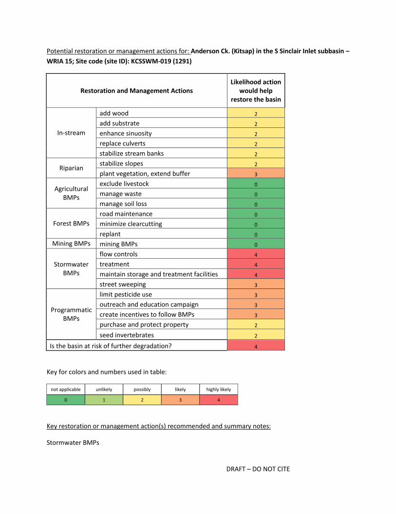
DRAFT – DO NOT CITE
Potential restoration or management actions for: Anderson Ck. (Kitsap) in the S Sinclair Inlet subbasin –
WRIA 15; Site code (site ID): KCSSWM-019 (1291)
Restoration and Management Actions Likelihood action
would help restore the basin
In-stream
add wood 2
add substrate 2
enhance sinuosity 2
replace culverts 2
stabilize stream banks 2
Riparian stabilize slopes 2
plant vegetation, extend buffer 3
Agricultural BMPs
exclude livestock 0
manage waste 0
manage soil loss 0
Forest BMPs
road maintenance 0
minimize clearcutting 0
replant 0
Mining BMPs mining BMPs 0
Stormwater BMPs
flow controls 4
treatment 4
maintain storage and treatment facilities 4
street sweeping 3
Programmatic BMPs
limit pesticide use 3
outreach and education campaign 3
create incentives to follow BMPs 3
purchase and protect property 2
seed invertebrates 2
Is the basin at risk of further degradation? 4
Key for colors and numbers used in table:
not applicable unlikely possibly likely highly likely
0 1 2 3 4
Key restoration or management action(s) recommended and summary notes:
Stormwater BMPs

DRAFT – DO NOT CITE
Recent development in the basin has changed the land use dramatically since 2001; between 2001 and
2011 the percent impervious surface in the watershed increased 6%. Kitsap County staff confirms that
the McCormick Woods development was approved in 2008, and before that the watershed provided
excellent habitat for fish. Additional high-density development continues in the lower basin (along
Anderson Hill Road SW), and further development is likely throughout the basin given that nearly 84% is
zoned for urban residential. An earlier development with homes built in the 1980s and 1990s along a
golf course may also be affecting water flow and water quality processes. Installing stormwater BMPs in
areas with older development, and maintaining stormwater facilities that target flow and water quality
in new developments, will be critical for maintaining, let alone restoring, conditions. As development
proceeds, it is recommended to leaveas much intact forest as possible, and to leave stream buffers as
wide as possible. If flow and water quality processes are protected from further degradation, in-channel
habitat actions may be needed to restore local conditions likely affected by the recent development.
Outreach to homeowners and the golf course encouraging minimal pesticide use may also be
appropriate given the high density of lawns, turf, and gardens, as well as the close proximity of
developments to the creek. Seeding may be appropriate if and when restoration actions have been
implemented, but there may also be adjacent watersheds with sufficient sources of diverse
invertebrates.
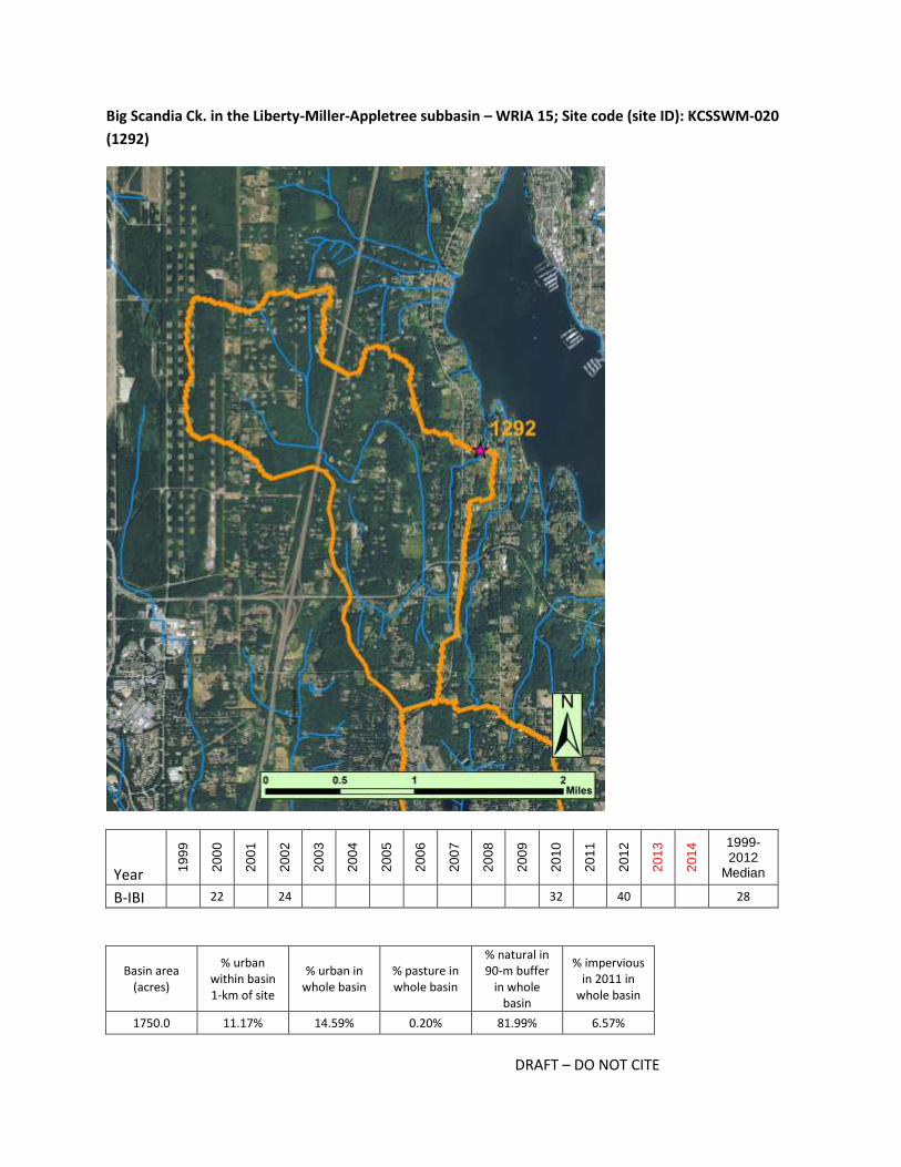
DRAFT – DO NOT CITE
Big Scandia Ck. in the Liberty-Miller-Appletree subbasin – WRIA 15; Site code (site ID): KCSSWM-020
(1292)
Year 19
99
20
00
20
01
20
02
20
03
20
04
20
05
20
06
20
07
20
08
20
09
20
10
20
11
20
12
20
13
20
14 1999-
2012 Median
B-IBI 22 24 32 40 28
Basin area (acres)
% urban within basin 1-km of site
% urban in whole basin
% pasture in whole basin
% natural in 90-m buffer
in whole basin
% impervious in 2011 in
whole basin
1750.0 11.17% 14.59% 0.20% 81.99% 6.57%

DRAFT – DO NOT CITE
Potential restoration or management actions for: Big Scandia Ck. in the Liberty-Miller-Appletree
subbasin – WRIA 15; Site code (site ID): KCSSWM-020 (1292)
Restoration and Management Actions Likelihood action
would help restore the basin
In-stream
add wood 2
add substrate 2
enhance sinuosity 2
replace culverts 2
stabilize stream banks 2
Riparian stabilize slopes 2
plant vegetation, extend buffer 3
Agricultural BMPs
exclude livestock 4
manage waste 4
manage soil loss 3
Forest BMPs
road maintenance 0
minimize clearcutting 0
replant 0
Mining BMPs mining BMPs 0
Stormwater BMPs
flow controls 3
treatment 3
maintain storage and treatment facilities 3
street sweeping 2
Programmatic BMPs
limit pesticide use 3
outreach and education campaign 4
create incentives to follow BMPs 3
purchase and protect property 2
seed invertebrates 3
Is the basin at risk of further degradation? 4
Key for colors and numbers used in table:
not applicable unlikely possibly likely highly likely
0 1 2 3 4
Key restoration or management action(s) recommended and summary notes:
Agricultural BMPs, stormwater BMPs targeting road runoff, seeding

DRAFT – DO NOT CITE
The Big Scandia Creek basin is zoned almost entirely for rural residential development, though there
appears to be commercial agriculture on some of the parcels. For example, there is a large pumpkin
patch in the eastern portion of the lower basin which is part the "backyard habitat" project. Outreach to
landowners to encourage agricultural BMPs are likely appropriate, especially for parcels adjacent to or
near the creek. Stormwater BMPs may be advantageous in some areas of the basin, including BMPs
designed to treat highway runoff from Rt 3 and Rt 308. The most recent BIBI score of 40 in 2012 is
encouraging and suggests conditions are perhaps better than the median BIBI score would suggest.
Although there are clearly some sensitive taxa present, seeding may be appropriate as it appears there
are few, if any, nearby sources of diverse invertebrates.

DRAFT – DO NOT CITE
Jump Off Ck. in the Bangor-Port Gamble subbasin – WRIA 15; Site code (site ID): KCSSWM-030 (1295)
Year 19
99
20
00
20
01
20
02
20
03
20
04
20
05
20
06
20
07
20
08
20
09
20
10
20
11
20
12
20
13
20
14 1999-
2012 Median
B-IBI 30 22 28 28 28
Basin area (acres)
% urban within basin 1-km of site
% urban in whole basin
% pasture in whole basin
% natural in 90-m buffer
in whole basin
% impervious in 2011 in
whole basin
830.9 51.07% 28.37% 0.48% 71.10% 13.47%

DRAFT – DO NOT CITE
Potential restoration or management actions for: Jump Off Ck. in the Bangor-Port Gamble subbasin –
WRIA 15; Site code (site ID): KCSSWM-030 (1295)
Restoration and Management Actions Likelihood action
would help restore the basin
In-stream
add wood 3
add substrate 3
enhance sinuosity 2
replace culverts 3
stabilize stream banks 2
Riparian stabilize slopes 2
plant vegetation, extend buffer 4
Agricultural BMPs
exclude livestock 0
manage waste 0
manage soil loss 0
Forest BMPs
road maintenance 0
minimize clearcutting 0
replant 0
Mining BMPs mining BMPs 0
Stormwater BMPs
flow controls 4
treatment 4
maintain storage and treatment facilities 4
street sweeping 3
Programmatic BMPs
limit pesticide use 2
outreach and education campaign 3
create incentives to follow BMPs 3
purchase and protect property 2
seed invertebrates 4
Is the basin at risk of further degradation? 3
Key for colors and numbers used in table:
not applicable unlikely possibly likely highly likely
0 1 2 3 4
Key restoration or management action(s) recommended and summary notes:
Stormwater BMPs, extend and replant buffer, outreach and in-channel actions if needed
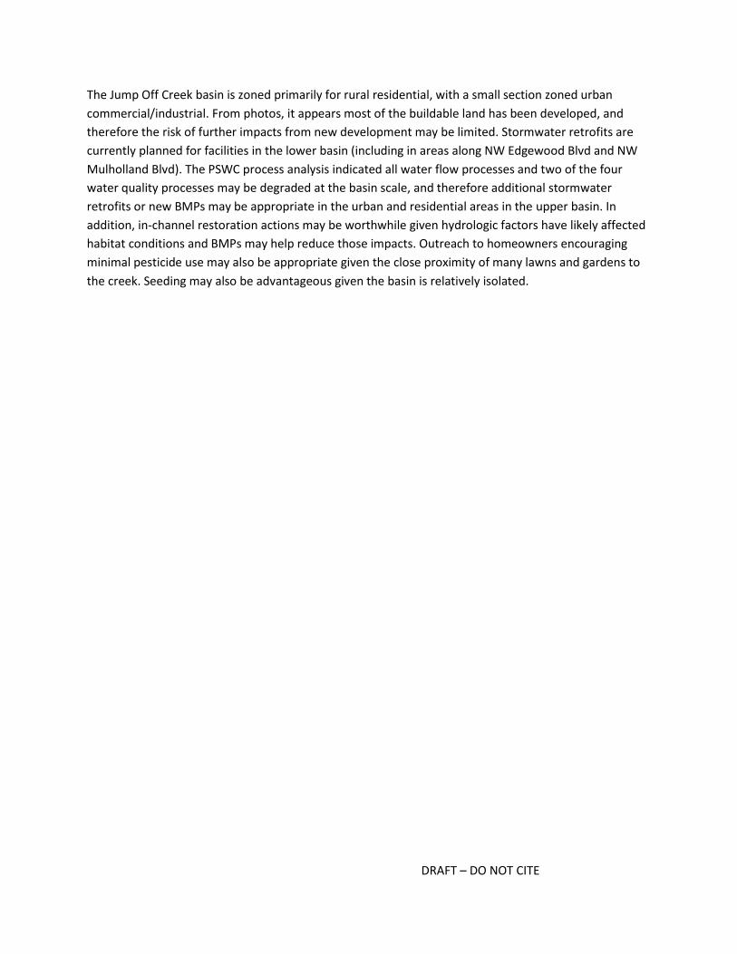
DRAFT – DO NOT CITE
The Jump Off Creek basin is zoned primarily for rural residential, with a small section zoned urban
commercial/industrial. From photos, it appears most of the buildable land has been developed, and
therefore the risk of further impacts from new development may be limited. Stormwater retrofits are
currently planned for facilities in the lower basin (including in areas along NW Edgewood Blvd and NW
Mulholland Blvd). The PSWC process analysis indicated all water flow processes and two of the four
water quality processes may be degraded at the basin scale, and therefore additional stormwater
retrofits or new BMPs may be appropriate in the urban and residential areas in the upper basin. In
addition, in-channel restoration actions may be worthwhile given hydrologic factors have likely affected
habitat conditions and BMPs may help reduce those impacts. Outreach to homeowners encouraging
minimal pesticide use may also be appropriate given the close proximity of many lawns and gardens to
the creek. Seeding may also be advantageous given the basin is relatively isolated.

DRAFT – DO NOT CITE
Bagley Ck. in the Siebert/McDonald Cks. subbasin – WRIA 18; Site code (site ID): BagleyClalCty4.6
(647)
Year 19
99
20
00
20
01
20
02
20
03
20
04
20
05
20
06
20
07
20
08
20
09
20
10
20
11
20
12
20
13
20
14 1999-
2012 Median
B-IBI 28 30 26 30 29
Basin area (acres)
% urban within basin 1-km of site
% urban in whole basin
% pasture in whole basin
% natural in 90-m buffer
in whole basin
% impervious in 2011 in
whole basin
1481.8 4.78% 2.90% 0.00% 96.01% 0.56%

DRAFT – DO NOT CITE
Potential restoration or management actions for: Bagley Ck. in the Siebert/McDonald Cks. subbasin –
WRIA 18; Site code (site ID): BagleyClalCty4.6 (647)
Restoration and Management Actions Likelihood action
would help restore the basin
In-stream
add wood 2
add substrate 2
enhance sinuosity 2
replace culverts 2
stabilize stream banks 2
Riparian stabilize slopes 1
plant vegetation, extend buffer 2
Agricultural BMPs
exclude livestock 0
manage waste 0
manage soil loss 0
Forest BMPs
road maintenance 2
minimize clearcutting 4
replant 3
Mining BMPs mining BMPs 0
Stormwater BMPs
flow controls 3
treatment 3
maintain storage and treatment facilities 4
street sweeping 2
Programmatic BMPs
limit pesticide use 2
outreach and education campaign 3
create incentives to follow BMPs 3
purchase and protect property 2
seed invertebrates 3
Is the basin at risk of further degradation? 4
Key for colors and numbers used in table:
not applicable unlikely possibly likely highly likely
0 1 2 3 4
Key restoration or management action(s) recommended and summary notes:
Maintain stormwater BMPs and possibly install additional stormwater BMPs, forestry BMPs, outreach

DRAFT – DO NOT CITE
The Bagley Creek basin is zoned primarily for rural residential, with a small portion of the upper basin
zoned for forest harvest. Parcels and the age of homes vary in size and age, respectively, but most
appear to be 2 to 5+ acres with homes built in the 1990s or 2000s. Given the age of the homes, it would
be expected that some stormwater BMPs had been required at the time of building and if this is the
case, those should be maintained. Additional stormwater BMPs and outreach to homeowners may also
be appropriate. The upper-most portion of the basin was recently logged and replanting may be
beneficial to minimize the delivery of sediment to the channel and stabilize flows. If reach-scale habitat
conditions appear good, seeding may be beneficial. If habitat conditions are poor, in-channel actions
may be needed but those should be implemented after basin-scale flow processes have been restored.