q n o lt - w ? my1204093
TRANSCRIPT

Q n O l t - W ? MY1204093
THE USE OF GPR TECHNIQUE IN THE SLOPE STABILITY SURVEY AT RADAR DOPPLER TERMINAL, BUKIT TAMPOI, DENGKIL, SELANGOR
Nurul Fairuz Diyana Binti Bahrudin2, Azmi Ismail, Amry Amin bin Abbas2 & Umar Hamzah1! Universiti Kebangsaan Malaysia
2Agensi Nuklear Malaysia
Abstract
A site investigation survey using GPR technique was carried out at Radar Doppler Terminal, Bukit Tampoi, Dengkil, Selangor. The Terminal is situated approximately 10 km to the North o f Kuala Lumpur International Airport. Geologically, the study area is located in the Kenny Hill formation consisting o f low grade metasedimentary rocks mainly o f quarzitc and phyllite. A detailed geotechnical investigation at a cut slope o f Kenny Hill formation in Selangor showed that the interbedded rock mass is dominated by relatively thick sandstone with thin shale o f slightly to highly weathered materials. The objective o f study is to investigate any fractured or weak zone in the study area using the GPR technique. In this survey, 100 MHz frequency antenna model RAMAC/GPR™ was used as a source to send the electromagnetic wave into the ground. A control unit (CUTI) was used in monitoring the antenna via a laptop, A total o f 25 parallel and vertical lines with 3m-5m spacing between each line were traversed in the study area. The maximum subsurface depth investigated was approximately 12m. Reflected waves arrival between 0m to 5m depth in the radargram section shows discontinuous, subparallel and wavy patterns. These chaotic reflections patterns correspond to highly weathered silt with sandstone and gravel based on nearby borehole information as well as indicated by low SPT N-values o f 0 to 13. For depth deeper than 5m, the reflection pattern is dominated by high frequency parallel waveform that could be associated with stiff mudstone o f 28-34 SPT N-values. The radargram section also shows the presence o f internal features in the metasedimcntary soils and rocks such as several small scale normal faults as well as sliding planes trending northwest-southeast in direction.
Keywords: ground penetrating radar, site; investigation, sedimentary rocks, faults
SURVEI KESTABILAN CERUN DENGAN TEKNIK GEORADAR DI STESEN RADAR KAJI CUACA , BUKIT TAMPOI, DENGKIL, SELANGOR
Satu survei penyiasatan tapak menggunakan teknik georadar telah dijalankan di Stesen Radar Kaji Cuaca, Bukit Tampoi, Mukim Dengkil, Selangor, Terminal Radar Kaji Cuaca (Radar Doppler Terminal, TDR) dipasang di Bukit Tampoi, iaitu kira-kira 10 km ke utara Lapangan Terbang Antarabangsa Kuala Lumpur. Kawasan kajian tcrlctak dalam Formasi Bukit Kenny yang terdiri daripada batuan metasedimen iaitu kuarzit dan filit bergred m etam orf rendah. Penyiasatan geoteknikal yang terperinci menunjukkan bahawa potongan cerun di Formasi Bukit Kenny di Selangor menujukkan perlapisan batuan yang didominasi oleh lapisan batu pasir yang tebal dengan lapisan syal yang nipis dan telah terluluhawa. Tujuan kajian ini adalah untuk mengenal pasti kedudukan kawasan rekahan, retakan dan zon Icmah. Teknik georadar menggunakan gelombang elektromagnet yang berfrekuensi 100 MHz yang di hantar dalam subpermukaan menggunakan antena model RAMAC/GPR™ . Jumlah rentasan yang dilakukan di sekitar kawasan kajian adalah sebanyak 25 garis, dimana jarak antara setiap garis adalah 3m hingga 5m, Kedalaman penyiasatan iafah 12m. Berdasarkan rajah radagram, kedalaman 0m hingga 5m menunjukkan pantulan yang berbentuk putus-putus dan tidak lurus serta bcrgclombang. Bcrdasarkan data lubang gerudi, lapisan ini terdiri daripada batu lodak dengan bam pasir dengan sedikit kelikir. Lapisan ini dianggap terluluhawa tinggi dengan nilai SPT yang agak rendah; berjulat dari 0 hingga 13. Lapisan yang lebih dalam daripada 5m, menunjukkan pola pantulan yang lurus dan berfrekuensi tinggi dalam radargram georadar yang mewakili bam lodak keras (SPT 29 hingga 34). Radagram juga menunjukkan imej beberapa struktur dalam tanih dan batuan metasedimen seperti sesar normal kecil dan satah gelinciran beijurus kemiringan BL- TGA di beberapa garis rentasan.
Katakunci: Radar penusukan bumi, penyiasatan tapak, batuan metasedimen, sesar
INTRODUCTION
Recently, various geophysical surveys were carried out in locating structures o f landslide (Grasmueck 1996). Among these, the ground penetrating radar (GPR) and the electrical imaging techniques are frequently used in such investigation (Imai et al. 1987). Stevens et al. (1995) applied GPR technique in the Canadian Nuclear Fuel Waste Management Program to map structural features in granite and gneissic rock o f the Canadian Shield as well as mapping the features in the tunnel and boreholes. In China, this technique has been applied in civil engineering exercises especially in the geotechnical aspects (Kong & By 1995). The GPR technique has proven to be very useful in solving engineering geological problems and detecting buried object in the ground especially faults and cavities (Benson 1995). Tn this study, the GPR technique was used to investigate fractured or weak zone in the meta-scdimentary soils and rocks. This study is part o f a slope stability detailed investigation by IKRAM (2007) as appointed by the Malaysian Public Work Department after the incident o f uncontrolled earthwork near the terminal which caused public awareness on the stability o f the slope.
LOCAL GEOLOGY
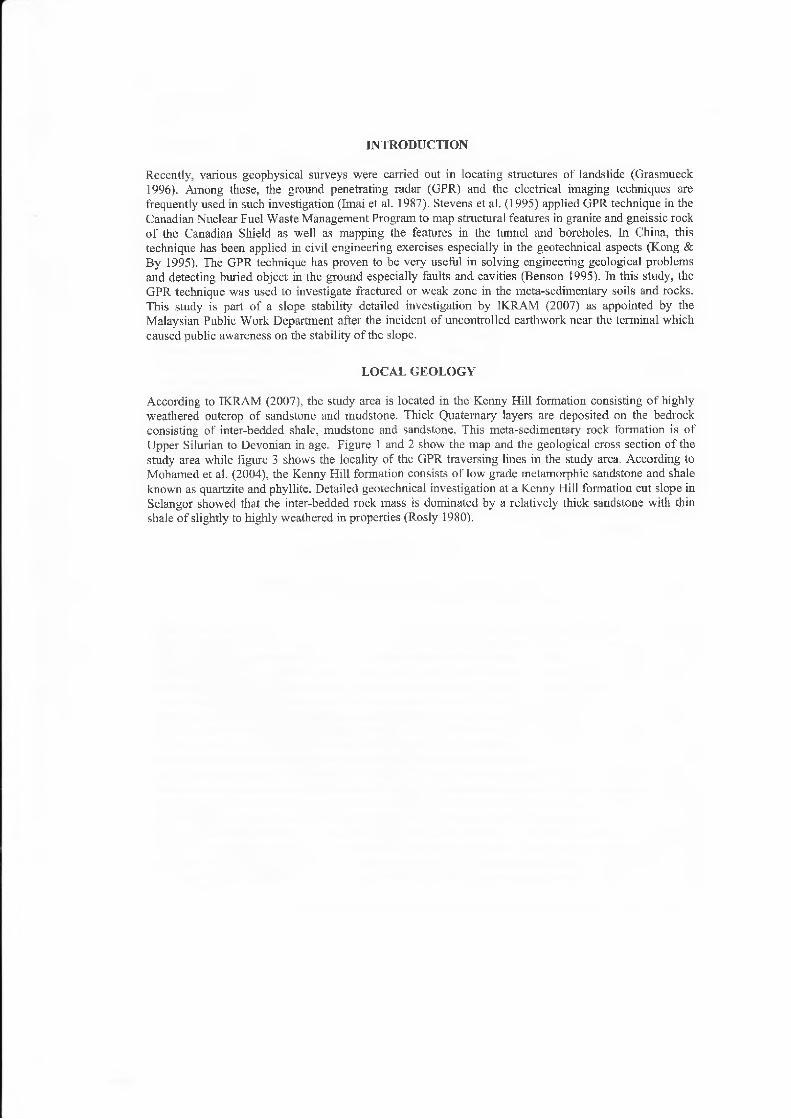
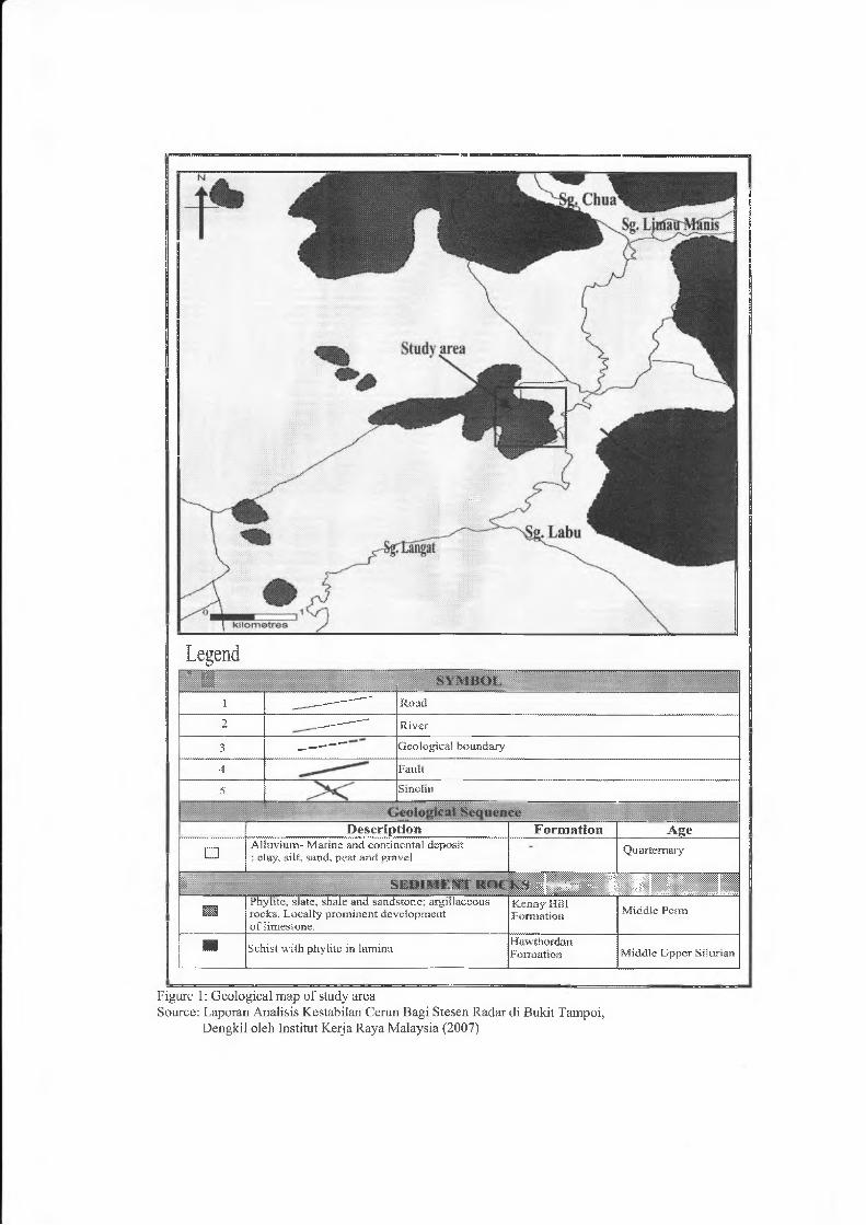
According to IKRAM (2007), the study area is located in the Kenny Hill formation consisting o f highly weathered outcrop o f sandstone and mudstone. Thick Quaternary layers are deposited on the bedrock consisting of inter-bedded shale, mudstone and sandstone. This meta-sedimentary rock formation is o f Upper Silurian to Devonian in age. Figure 1 and 2 show the map and the geological cross section o f the study area while figure 3 shows the locality o f the GPR traversing lines in the study area. According to Mohamed et al. (2004), the Kenny Hill formation consists o f low grade metamorphic sandstone and shale known as quartzite and phyllite. Detailed geotechnical investigation at a Kenny Hill formation cut slope in Selangor showed that the inter-bedded rock mass is dominated by a relatively thick sandstone with thin shale o f slightly to highly weathered in properties (Rosly 1980).
Legend7 n
i —---- ------ " Road
2 ---------- - Rivec
3 ---------- - Geological boundary
4 Fault
5 ......... Sinclii)
■ m D escrip tion Form ation A ge
□Alfaviura- Marine and continental deposit • clay, silt, sand, peat and gravel
Q uartem aiy
L ........... S K D 1M I.M UOf. ■ H H IH i
Phylhe, slate, shale and sandstone; argillaceous rocks. Locally prom inent development o f limestone.
Kenny Hill Formation M iddle Perm
■ Schist w ith phylite in lamina HawthordanForrsatsola M iddle Upper Silurian
Figure 1: Geological map of study areaSource: Laporan Analisis Kestabilan Cerun Bagi Stesen Radar di Bukit Tampoi,
Dengkil oleh Institut Keija Raya Malaysia (2007)
Geo
logi
cal
Cros
s Se
ctio
n At
Buk
it Ta
mpo
i, D
engk
il
(ui) jq g p H
oooCN
a&&03’P?<U
o33
.£3<D
a
1asa :
: • Q
0tcdH
1 m
T 3c3C*a<D
*ca
§!§ . I l f
a >
E l l iai S b
1
■p
u* r i l iP Ip f
<i>O§
<4h0
1 j<1> (D
J> S s aO §■
CN T"!e 8i—t JhS/i 3 J oPh C A

fi
111««i 11M«„i«in«111 iiLi..
M5. J
ir,MV J
• -̂-------------------------------
. ____________
r*l CN i 1
CNr-j ̂ 1
___ V."V™- ™ ’"— 'T l
.#.....................
— 1 >|_ _
mm ms7 W *
CN
m ■
£ < -
o ,
... |
■ ' - ^ ■ j
V
.....%
..... >
Figu
re
3: Lo
calit
y m
ap

THEORY GERORADAR
Ground Penetrating Radar (GPR) is one of the geophysical techniques basically utilizing electromagnetic wave as a source of input energy in investigating the physical properties of shallow earth materials. Recently, it is widely applied in solving problems encountered in civil engineering and geotcchnical disciplines especially in detecting and characterizing the subsurface structures. The GPR technique which was first introduced in 1937 is basically consisting of a portable device that produces high resolution image of any structure below the surface (Davis & Annan, 1989). Its use has now being extended into the application of environmental, geotechnical, and archaeological aspects especially in exploring the related features as given in table 1.
Field Aplication
Environmental Mapping of hazardous waste
Mapping o f underground storage tanks,
Study of sedimentology, Bathymetry
Geotechnical Stratigraphy mapping of sinkhole and cavity area Groundwater investigation, localizing the weak and fractured zone.Details study in tunnels and dams
Archeology Mapping archeology features
Table 1: The application of GPR
This technique uses transmitter and receiver mounted at a fixed position in a box as. antenna (Figure 4). When an electromagnetic wave is transmitted into the ground, at any boundary separating two different media with different dielectric constants ( £ ) , part of the incoming or incident waves are reflected back to the surface with
. s 2 ~ e \amplitudes proportional to the reflection coefficient as calculated by <J — — -------e2 + £ ]
According to Mohamad Pauzi et al. (2004), the remaining waves will penetrate further down into the subsurface materials. Basically, this technique is similar to the seismic reflection and sonar in principle. An electromagnetic wave will be radiated into the ground via a transmitter antenna. When the radiated wave encounters different medium, part o f the wave is reflected back to the antenna and part o f it will be transmitted into the ground. The reflected waves will be recorded and saved by the receiver antenna as raw data.
Tx: Transmitter antenna Rx: Receiver antenna
Figure 4: Basic principle of GPR
METHODOLOGY
In this study, 100 MHz antenna was connected to the control unit to generate input waves. This control unit is used as a data collcctor dining measurement and was connected to a laptop for data analysis via Ground Vision1 M software. In this study, single channel profiling or common midpoint (CMP) with fixed offset was used throughout the survey. During data acquisition, the box containing the transmitter and receiver antenna was slowly dragged along the traverse lines and the reflected waves were continuously recorded by the receiver. The ground vision software, will instantly display a time section representing common offset section on the laptop screen in two-way time versus distance scales. Appropriate ground velocity is required as input to the software before the time scales section can be converted into depth scales. 100 ms / mm velocity is commonly used to represent dry clay and sand for time-depth conversion. A total of 25 parallel and vertical lines with 3m-5m spacing between each line were traversed in the study area,
RESULT AND DISCUSSION
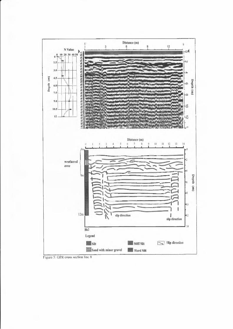
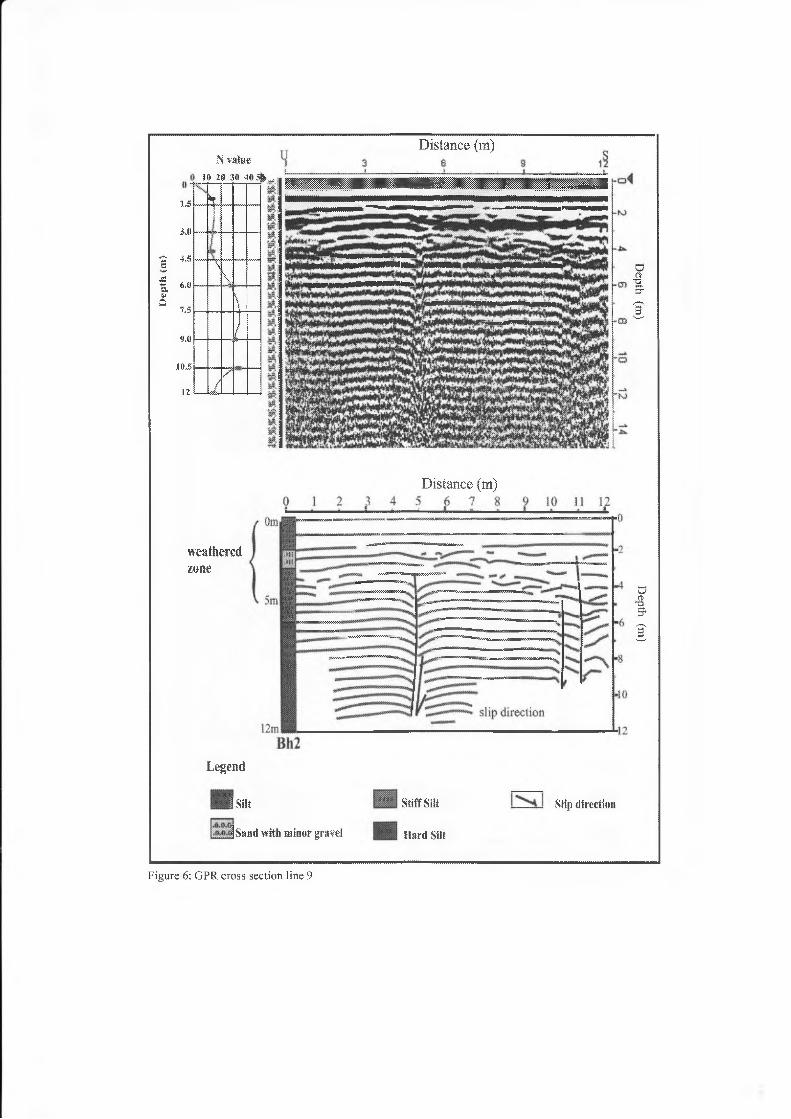
Almost all o f the total 25 lines acquired during the survey showed similar pattern of reflections as displayed in the cross sections. The reflection patterns can mainly be classified into several groups. The first and foremost pattern is called chaotic characterized by discontinuous, wavy with mixed frequencies reflections as well as sometimes showing sub-parallel in nature. These patterns are observed and dominant at depth between 0m-5m. Based on correlation with the closest borehole information, they can be associated with highly weathered and water saturated top meta-sedimentary soil. The chaotic nature of the reflection patterns can probably be due to the inhomogeneity of the soil in terms of water saturations. Geologically, this interval consists of sand and small gravel stones with low standard penetration test (SPT) N-values of 0 to 13 indicating soft materials. Below this chaotic layer, a total different of reflection pattern is observed especially at depth of 5m to 12m, This zone is dominated by parallel waves reflections with medium to high frequencies as well as high amplitudes. Based on borehole data, this zone is represented by hard siltstone with SPT N-values of 29-34. The higher reflection amplitudes could be due to the presence of harder soil formation as indicated by higher SPT N-values. The interpretation is based on comparison with the geological cross section of the study area obtained from boreholes. The presence of small faults and joints were also observed in the GPR lines 8 and 9 (Fig 5 & 6). These steep angle faults have a maximum vertical size of about 6m. The faults are dipping towards the north and south with high dip angles between 70D-80°. Two normal faults are also observed on line 22 and 23 (Fig. 7 & 8) in fresh meta-sedimentary rock layer with a distance o f 5m between each other.
Another interesting feature detected by the GPR survey in the study area was the presence, o f quite a striking sliding or fault planes. These sliding planes approximate size were 12-15 m in length and located at depth of 5m and 10m. These planes were only detected in GPR line 22 and 23 with dipping angles between 20°- 30“ towards the west. The presence of sliding planes in any area particularly the study area implies that it is not safe to be a foundation of any building structure sitting on it. Geologically, areas with sliding pianes can be considered as hazardous or instabie zone. The areas surrounding or overlying this weak zone can easily move along the planes due to vibrations originating from either earthquake or movements of heavy vehicles. Detailed study was carried out on these GPR sections in terms of locating planes movement. Drag features was not observed above and below the fault planes indicating no movements of soil mass on either side of the planes. These inactive planes can be classified geologically as relic joints or cracks in the meta-sedimentary bedrock.
Dep
th
(m)
0 1 2t ■ »____________________________ I___ I------------L-----------1------------1------------ i------------L
weatheredzone
stiff sat
Hard Silt
| *s-s4 j Slip direction
Figure 5: GPR cross section line 8
IJepth (m
) D
epth (m
)
Dept
h (m
)
LS
Mi
4.5
6.0
7.5
9.0
1.0,5
12
N value 10 20 30 4 0 ^
h?
sh
\l
— dA
{
Distance (m)
weatheredzone
Legend
Distance (m)
I Silt
|San(t witii minor gravel
Stiff Sift
Hard Silt
Slip direction
Figure 6: GPR cross section line 9
Depth
(m)
Depth (m
)

N Value
Distance (m)
Distance (m)
weathered?,one
Silt
Saad with minor gravel
Stiff Silt
Hard Silt
N Slip direct ion
Figure 7: GPR cross section line 22

1
i7£3
Distance (m)s 12
O%Er
I Slip direction
D istan ce (in.)
stiff sat
Hard Silt
weatheredzone
Legend
.o-MSanil with minor gravel
Figure 8: GPR cross section line 23

CONCLUSION
The presence of numerous faults and fractures are normal in the older tectonically deformed meta-sedimentary rocks. These faults and fractures can sometimes still be observed in the upper part of the formation even after intense weathering processes that turn the rock into soils. These structures are even much more clear in the slightly and fresh bedrock. Based on all 4 GPR cross sections, the under study radar station can be considered as instable in the future. The station is not stable because it lies on foundation with many fault and joint structures. There are a lot of possibilities for the whole area to slip especially along the weak zones located below the station building. Under tropical climate with high rate o f precipitation, the weak zones can become easily saturated with water and hence reducing the surrounding soil particles retention force to easily cause sliding. The soil sliding can be further enhanced by the absence of retaining walls on the cut slopes surrounding the station. As a long-term security measures, it is recommended to install retaining walls plus appropriate runoff system around the radar station to avoid any unlikely soil movement or soil sliding. The soil sliding is possible when fully saturated with water which reduced the soil strength. Fault structure was not observed in the highly weathered area from top to about 5m depth. The presence of high water content in the zone destroyed any remaining relic fault structure. In deeper part of the section, the bedrock structures are not changed in the absence of water.
REFERENCES
Benson, A.K. 1995. Application of ground penetrating radar in assessing some geological hazards:Examples of groundwater contamination, faults and cavities. J. Appl. Geophys. 33: 177-193.
Davis, J.L. and Annan, A.P. 1989. Ground penetrating radar for high resolution mapping of soil and rock stratigraphy: Geophysical Prospecting 37: 531-551.
.Institut Kerja Raya Malaysia (IKRAM) 2007. Laporan Analisis Kestabilan Cerun Bagi Stesen Radar di Bukit Tampoi, Dengkil oleh Institut Kcija Raya Malaysia,
Grasmueck, M. 1996. 3-D Ground penetrating radar applied to fracture imaging in gneiss. Geophysics 61:1050-1064
Imai, T., Sakayama, T. and Kanemori, T. 1987. Use of ground penetrating radar and resistivity surveys for archaeological investigations. Geophysics 52: 137-150
Kong, F.N. and By, T.L. 1995. The performance of a GPR system which uses step frequency signals. J.Appl. Geophys. 33: 15-26
Mohamad Pauzi, Mohd Azmi Ismail, Amry Amin Abas dan Suhairy Sani. 2004.Application of Ground Penetrating Radar (GPR) in concrete inspection and geotechnical studies. Prosiding Seminar Geofizik-Peningkatan mutu dan kecekapan teknik geofizik dalam penyiasatan tapak, ESSET, Bangi-Selangor. Page: 1-5
Mohamed Zamri, Abdul Ghani. Rafek, and Ibrahim Komoo. 2004. GeomechanicalBehaviour o f Interbedded Rock Mass of Kenny I-Iill Formation, Selangor. Malaysia. Proc.of the 4th Asian Symp on Engineering Geology and The Environment. Geological Society of Hong Kong. Page: 179-182
Rosly Mohd Nor. 1980. Geology of Kenny Hill formation Selangor, Peninsular Malaysia, Bachelor of Science Theses University o f Malaya (Unpublished)
Stevens, K.M., Lodha, G.S., Holloway, A.L. and Soonawala, N.M. 1995. The application of ground penetrating radar for mapping fractures in plutonic rock within the Witheshell Research Area,Pinawa, Manitoba, Canada. J. Appl, Geophys. 33 (1): 125-141