quality assessment of image fusion … · quality assessment of image fusion techniques for multise...
TRANSCRIPT

QUALITY ASSESSMENT OF IMAGE FUSION TECHNIQUES FOR MULTISENSOR
HIGH RESOLUTION SATELLITE IMAGES (CASE STUDY: IRS-P5 AND IRS-P6
SATELLITE IMAGES)
M. Fallah Yakhdani , A. Azizi
Centre of Excellence for Natural Disaster Management, Department of Geomatics Engineering,
College of Engineering, University of Tehran, Iran - ([email protected], [email protected])
Commission VII, WG VII/6
KEY WORDS: Fusion, IRS, Multisensor, Spatial, Spectral, Evaluation
ABSTRACT:
This paper is concentrated on the evaluation of the image fusion techniques applied on the IRS P5 and P6 satellite images. The study
area is chosen to cover different terrain morphologies. A good fusion scheme should preserve the spectral characteristics of the
source multi-spectral image as well as the high spatial resolution characteristics of the source panchromatic image. In order to find
out the fusion algorithm which is best suited for the P5 and P6 images, five fusion algorithms, such as Standard IHS, Modified IHS,
PCA, Brovey and wavelet algorithms have been employed and analyzed. In this paper, eight evaluation criteria are also used for
quantitative assessment of the fusion performance. The spectral quality of fused images is evaluated by the Spectral discrepancy,
Correlation Coefficient (CC), RMSE and Mean Per Pixel Deviation (MPPD). For the spatial quality assessment, the Entropy, Edge
detection, High pass filtering and Average Gradient (AG) are applied and the results are analyzed. The analysis indicates that the
Modified IHS fusion scheme has the best definition as well as spectral fidelity, and has better performance with regard to the high
textural information absorption. Therefore, as the study area is concerned, it is most suited for the IRS-P5 and P6 image fusion.
1. INTRODUCTION
Due to physical constraint, there is a trade off between spatial
resolution and spectral resolution of a high resolution satellite
sensor (Aiazzi et al., 2002), i.e., the panchromatic image has a
high spatial resolution at the cost of low spectral resolution, and
the multispectral image has high spectral resolution with a low
spatial resolution (IKONOS: panchromatic image, 1m,
multispectral image 4m; QuickBird: panchromatic image,
0.62m, multispectral image, 2.48m). To resolve this dilemma,
the fusion of multispectral and panchromatic images, with
complementary spectral and spatial characteristics, is becoming
a promising technique to obtain images with high spatial and
spectral resolution simultaneously (Gonzalez-Audicana et al.,
2004). Image fusion is widely used to integrate these types of
data for full exploitation of these data, because fused images
may provide increased interpretation capabilities and more
reliable results since data with different characteristics are
combined. The images varying in spectral, spatial and temporal
resolution may give a more comprehensive view of the
observed objects (Pohl and Genderen, 1998).
2. IMAGE FUSION ALGORITHMS
Many methods have been developed in the last few years
producing good quality merged images. The existing image
fusion techniques can be grouped into four classes: (1) color
related techniques such as intensity–hue–saturation (IHS) ; (2)
statistical/numerical methods such as principal components
analysis (PCA), high pass filtering (HPF), Brovey transform
(BT), regression variable substitution (RVS) methods; (3)
Pyramid based Methods such as Laplacian Pyramid, Contrast
Pyramid, Gradient Pyramid, Morphological Pyramid and
Wavelet Methods and (4) hybrid methods that use combined
methods from more than one group such as IHS and wavelet
integrated method. This study analyzes five current image
fusion techniques to assess their performance. The five image
fusion methods used include Standard IHS, Modified IHS,
PCA, Brovey and wavelet algorithms.
IHS (Intensity-Hue-Saturation) is the most common image
fusion technique for remote sensing applications and is used in
commercial pan-sharpening software. This technique converts a
color image from RGB space to the IHS color space. Here the I
(intensity) band is replaced by the panchromatic image. Before
fusing the images, the multispectral and the panchromatic image
are histogram matched.
Ideally the fused image would have a higher resolution and
sharper edges than the original color image without additional
changes to the spectral data. However, because the
panchromatic image was not created from the same wavelengths
of light as the RGB image, this technique produces a fused
image with some color distortion from the original multispectral
(Choi et al., 2008). There have been various modifications to
the IHS method in an attempt to fix this problem (Choi et al.,
2008; Strait et al., 2008; Tu et al., 2004; Siddiqui, 2003). In this
research is used modification method suggested by Siddiqui
(2003).
The Principal Component Analysis (PCA) is a statistical
technique that transforms a multivariate dataset of correlated
variables into a dataset of new uncorrelated linear combinations
of the original variables (Pohl and Genderen, 1998). It is
assumed that the first PC image with the highest variance
contains the most amount of information from the original
image and will be the ideal choice to replace the high spatial
resolution panchromatic image. All the other multispectral
bands are unaltered. An inverse PCA transform is performed on
the modified panchromatic and multispectral images to obtain a
high-resolution pan-sharpened image.
In: Wagner W., Székely, B. (eds.): ISPRS TC VII Symposium – 100 Years ISPRS, Vienna, Austria, July 5–7, 2010, IAPRS, Vol. XXXVIII, Part 7BContents Author Index Keyword Index
204
Brovey Transform uses addition, division and multiplication for
the fusion of three multispectral bands (ERDAS, 1999). Its
basic processing steps are: (1) add three multispectral bands
together for a sum image, (2) divide each multispectral band by
the sum image, (3) multiply each quotient by a high resolution
pan.
In wavelet fusion method First, three new panchromatic images
are produced according to the histogram of R, G, B bands of
multispectral image respectively. Then each of the new high-
resolution panchromatic images is decomposed into a low-
resolution approximation image and three wavelet coefficients,
also called detail images, which contain information of local
spatial details. The decomposed low-resolution panchromatic
images are then replaced by the real low-resolution
multispectral image bands (B,G,R), respectively. In the last
step, a reverse wavelet transform is applied to each of the sets
containing the local spatial details and one of the multispectral
bands (B,G,R). After three times of reverse wavelet transforms,
the high-resolution spatial details from the panchromatic image
are injected into the low-resolution multispectral bands resulting
in fused high-resolution multispectral bands (Zhang, 2005).
3. QUALITY ASSESSMENT CRITERIA
Quality refers to both the spatial and spectral quality of images
(Wald, 1997). Image fusion methods aim at increasing the
spatial resolution of the MS images while preserving their
original spectral content. The evaluation of the fusion results is
based on the quantitative criteria including spectral and spatial
properties and definition of images (Xu, 2004). In this paper,
eight evaluation criteria are used for quantitative assessment of
the fusion performance. The spectral quality of fused images is
evaluated by the Spectral discrepancy, Correlation Coefficient
(CC), RMSE and Mean Per Pixel Deviation (MPPD). For the
spatial quality assessment, the Entropy, Edge detection, High
pass filtering and Average Gradient (AG) are applied and the
results are analyzed.
3.1 Spectral Quality Assessment
The basic principle of spectral fidelity is that the low spatial
frequency information in the high-resolution image should not
be absorbed to the fusion image, so as to preserve the spectral
content of original MS image. The indexes which can inflect the
spectral fidelity of fusion image include:
3.1.1 Correlation Coefficient: CC measures the correlation
between the original and the fused images. The higher the
correlation between the fused and the original images, the better
the estimation of the spectral values (Han et al.,2008). The ideal
value of correlation coefficient is 1.
22
( )( )
( , )
( ( ) )( ( ) )
mn mn
mn
mn mn
mn mn
A A B B
CC A B
A A B B
− −
=
− −
∑
∑ ∑
where A and B stand for the mean values of the
corresponding data set, and CC is calculated globally for the
entire image.
3.1.2 RMSE: RMS error as proposed by Wald (2002), which
is computed as the difference of the standard deviation and the
mean of the fused and the original image. The formula for
RMSE is:
2 2
org fused
org fused
RMSE bias
bias x x
σ
σ σ σ
= +
= +
= −
(2)
In this formula s is standard deviation, x is Mean, org is
Original image and fused is Fused image.
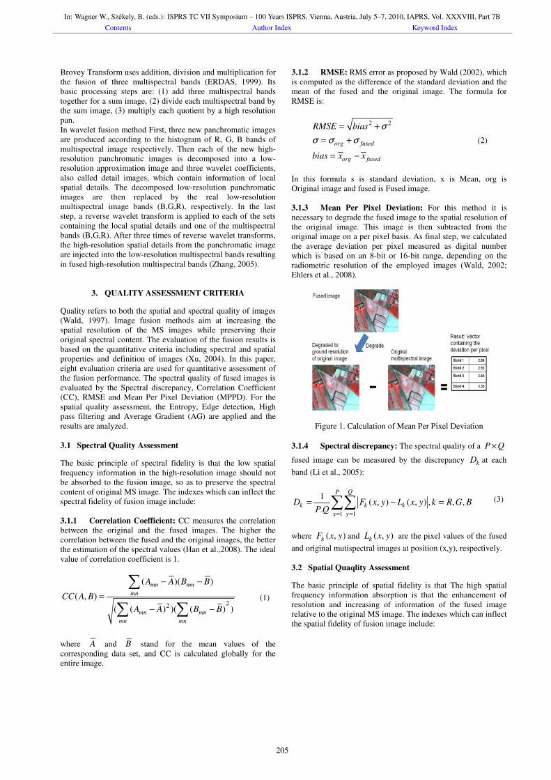
3.1.3 Mean Per Pixel Deviation: For this method it is
necessary to degrade the fused image to the spatial resolution of
the original image. This image is then subtracted from the
original image on a per pixel basis. As final step, we calculated
the average deviation per pixel measured as digital number
which is based on an 8-bit or 16-bit range, depending on the
radiometric resolution of the employed images (Wald, 2002;
Ehlers et al., 2008).
Figure 1. Calculation of Mean Per Pixel Deviation
3.1.4 Spectral discrepancy: The spectral quality of a P Q×
fused image can be measured by the discrepancy kD at each
band (Li et al., 2005):
1 1
1( , ) ( , ) , , ,
.
QP
k k k
x y
D F x y L x y k R G BP Q
= =
= − =∑∑
where ( , )kF x y and ( , )kL x y are the pixel values of the fused
and original mutispectral images at position (x,y), respectively.
3.2 Spatial Quaqlity Assessment
The basic principle of spatial fidelity is that The high spatial
frequency information absorption is that the enhancement of
resolution and increasing of information of the fused image
relative to the original MS image. The indexes which can inflect
the spatial fidelity of fusion image include:
(1)
(3)
In: Wagner W., Székely, B. (eds.): ISPRS TC VII Symposium – 100 Years ISPRS, Vienna, Austria, July 5–7, 2010, IAPRS, Vol. XXXVIII, Part 7BContents Author Index Keyword Index
205

3.2.1 High Pass Filtering: For the spatial quality, we
compare the high frequency data from the panchromatic image
to the high frequency data from each band of the fused image
using a method proposed by Zhou in 2004. To extract the high
frequency data we apply the following convolution mask to the
images:
1 1 1
1 8 1
1 1 1
mask
− − −
= − − − − −
The correlation coefficients between the high-pass filtered
fusion results and the high-pass filtered panchromatic image is
used as an index of the spatial quality (Hong, 2007). The
principle is that the spatial information unique in panchromatic
image is mostly concentrated in the high frequency domain. The
higher correlation between the high frequency components of
fusion result and the high frequency component of
panchromatic image indicates that more spatial information
from panchromatic image has been injected into the fusion
result.
Figure 2. Spatial quality assessment by high pass filtering
3.2.2 Edge detection: In this method first detect the edges of
panchromatic and fused image by canny operator. the more
closely the edge data of the fused image matches the edge data
of the panchromatic, indicating better spatial quality.
Figure 3. Spatial quality assessment by edge detection
3.2.3 Average gradient: For the spatial quality, we use the
average gradient to evaluate the performance of the fused image
F. That is
2 21
1
11
( , ) ( , )( ) ( )
1
( 1)( 1) 2
, ,
k kP
Q
k yx
F x y F x y
x yag
P Q
k R G B
−−
=
=
∂ ∂+
∂ ∂= ×
− −
=
∑∑
(5)
where ( , )kF x y is the pixel value of the fused image at
position (x,y). The average gradient reflects the clarity of the
fused image. It can be used to measure the spatial resolution of
the fused image, i.e., a larger average gradient means a higher
spatial resolution (Li et al., 2005).
3.2.4 Entropy: Entropy as a measure to directly conclude
the performance of image fusion. The Entropy can show the
average information included in the image and reflect the detail
information of the fused image (Han et al.,2008). Commonly,
the greater the Entropy of the fused image is, the more abundant
information included in it, and the greater the quality of the
fusion is. According to the information theory of Shannon, The
Entropy of image is:
255
2
0
logi i
i
E P P
=
= −∑
Where E is the Entropy of image, and iP is the probability of i
in the image.
4. EXPERIMENT DATA AND ANALYSIS OF FUSION
RESULTS
4.1 Experiment Data
The image fusion techniques applied on the IRS P5 and P6
satellite images. IRS-P6 multispectral image has three 5.8-m
resolution spectral bands (Green,Red,NIR) and resolution of
IRS-P5 panchromatic image is 2.5-m. The study area is chosen
to cover different terrain morphologies. Figure 4 shows an
example of the fused IRS-P6 MS and IRS-P5 pan images using
five fusion algorithms, such as Standard IHS, Modified IHS,
PCA, Brovey and wavelet algorithms.
4.2 Analysis of Fusion Results
Initial qualitative visual inspections reveal that all the fused
images have better qualifications than original non-fused
images. The sharpness of the fused images has been
significantly enhanced. The further quantitative evaluation can
be done with above criteria.
4.2.1 Spatial Quality Assessment: Figure 5 shows the
correlation coefficients between high pass filtered results and
high pass filtered panchromatic image, PC is the highest,
Standard IHS is the second and wavelet is the lowest. That
means the PC and Standard IHS fusion results are injected into
the most spatial information, while the wavelet fusion result is
injected into the least spatial information.
The average gradients of the images obtained by different
fusion algorithms are shown in figure 6. The ag of Standard IHS
is the highest in the five algorithms, and ag of PC and Modified
IHS is the further maximum. therefore, the Standard IHS-fused
image has absorbed the high spatial frequency information most
and thus shows sharper than the others.
(4)
(6)
In: Wagner W., Székely, B. (eds.): ISPRS TC VII Symposium – 100 Years ISPRS, Vienna, Austria, July 5–7, 2010, IAPRS, Vol. XXXVIII, Part 7BContents Author Index Keyword Index
206

(a) (b)
(c) (d)
(e) (f)
(g)
Figure 4. (a) original Pan image. (b) original MS image. (c)
Standard IHS fused image. (d) modified IHS fused image. (e)
PC fused image. (f)Wavelet fused image. (g)Brovey fused imge.
Figure 7 shows the Entropy of each band MS and fused images.
The Entropy of Standard IHS is the highest in the five
algorithms. The Entropy can reflect the average information
included in the fused image, therefore, the Standard IHS-fused
image has absorbed the high spatial frequency information most
and thus shows crisper than the others. Entropy of PC is the
further maximum and Entropy of Brovey is minimum.
figure 8 shows the wavelet fusion result has the lowest of edge
accordance whit panchromatic image in the five algorithms, that
indicating worse spatial quality.
0
0.2
0.4
0.6
0.8
1
1.2
Band R(NIR) 0.633 0.855 0.836 0.876 0.848 0.665
Band G(R) 0.59 0.859 0.885 0.965 0.903 0.65
Band B(G) 0.62 0.816 0.832 0.936 0.888 0.642
MS S. IHS Mod.IHS PC Brovey Wavelet
Figure 5. Correlation coefficients between the high pass filtered
panchromatic image and high pass filtered fusion results.
0
2
4
6
8
10
12
14
Band R(NIR) 6.257 1.924 2.518 1.222 1.62
Band G(R) 12.684 3.862 6.667 2.47 3.191
Band B(G) 11.434 3.861 5.198 2.304 2.952
S. IHS Mod.IHS PC Brovey Wavelet
Figure 6. Average gradients of the fused images.
0
2
4
6
8
Band R(NIR) 4.861 6.732 4.922 5.528 4.399 5.034
Band G(R) 6.114 6.59 6.165 6.912 5.558 6.14
Band B(G) 5.714 7.589 6.044 6.553 5.342 5.759
MS S. IHS Mod.IHS PC Brovey Wavelet
Figure 7. Entropy of the MS and fused images.
In: Wagner W., Székely, B. (eds.): ISPRS TC VII Symposium – 100 Years ISPRS, Vienna, Austria, July 5–7, 2010, IAPRS, Vol. XXXVIII, Part 7BContents Author Index Keyword Index
207

0.00%
20.00%
40.00%
60.00%
80.00%
100.00%
Band R(NIR) 92.71% 87.24% 88.91% 87.05% 81.03%
Band G(R) 98.00% 91.12% 95.87% 92.59% 81.43%
Band B(G) 93.83% 88.83% 93.09% 91.49% 81.49%
S. IHS Mod.IHS PC Brovey Wavelet
Figure 8. edge accordance of fused images whit panchromatic
image
4.2.2 Spectral Quality Assessment: In Figure 9, the original
panchromatic image has a low correlation with the original
multispectral image. The correlation between the fusion result
and multispectral image are much greater than the correlation
between the panchromatic
image and multispectral image. The highest correlation
coefficient is wavelet, therefore According to this quantitative
analysis, wavelet is the best that means preserve the spectral
characteristics of the source multi-spectral image.
figure 10 shows the spectral discrepancies between the images
obtained by different fusion algorithms and the source
multispectral image. It clearly indicates that the discrepancy of
wavelet is the minimum, and discrepancies of Modified IHS is
the further minimum. So wavelet is the best method in retaining
spectral property of the original image among the five used
methods and Modified IHS takes second place.
Figure 11 shows the RMSE of MS and fused images. It clearly
indicates that the RMSE of wavelet is the minimum, and RMSE
of Modified IHS is the second minimum.
Figure 12 shows that The MPPD of PC-fused image is the
highest in the five algorithms. wavelet is the minimum.
According to the RMSE and MPPD, we can see that the
wavelet-fused image has the maximal relativity with MS image.
So wavelet is the best method in retaining spectral property of
the original image among the five used methods, and Modified
IHS takes second place.
0
0.2
0.4
0.6
0.8
1
Band R(NIR) 0.354 0.468 0.551 0.657 0.616 0.919
Band G(R) 0.55 0.598 0.665 0.605 0.672 0.951
Band B(G) 0.593 0.649 0.637 0.682 0.665 0.933
Pan S. IHS Mod.IHS PC Brovey Wavelet
Figure 9. Correlation coefficient between the original
multispectral image and fusion results
0
10
20
30
40
50
60
Band R(NIR) 20.192 5.337 18.479 24.83 1.835
Band G(R) 41.422 10.579 53.245 50.523 3.661
Band B(G) 34.867 9.294 36.941 41.887 3.124
S. IHS Mod.IHS PC Brovey Wavelet
Figure 10. Spectral discrepancies between the the original
multispectral image and fusion results
0
10
20
30
40
50
60
Band R(NIR) 20.181 0.609 18.521 24.996 0.326
Band G(R) 43.255 0.385 53.873 50.888 0.392
Band B(G) 38.407 3.329 37.726 42.018 0.308
S. IHS Mod.IHS PC Brovey Wavelet
Figure 11. RMSE between the the original multispectral image
and fusion results
0
10
20
30
40
50
60
Band R(NIR) 13.232 2.517 18.354 16.342 0.829
Band G(R) 28.068 5.098 52.766 28.654 1.643
Band B(G) 23.678 4.664 36.705 22.422 1.41
S. IHS Mod.IHS PC Brovey Wavelet
Figure 12. MPPD of the fused images.
5. CONCLUSIONS
Finally, from the above analysis and comparison, we can
conclude that Modified IHS algorithm can preserve the spectral
characteristics of the source multispectral image as well as the
high spatial resolution characteristics of the source
panchromatic image and suited for fusion of IRS P5 and P6
images.
In PC and Standard IHS image fusion, dominant spatial
information and weak colour information is an often problem,
Therefore are suited for visual interpretation, image mapping,
and photogrammetric purposes.
In: Wagner W., Székely, B. (eds.): ISPRS TC VII Symposium – 100 Years ISPRS, Vienna, Austria, July 5–7, 2010, IAPRS, Vol. XXXVIII, Part 7BContents Author Index Keyword Index
208
wavelet is the best method in retaining spectral property of the
original image among the five used methods at the cost of low
spatial information, Therefore are suited for digital
classification purposes.
References
Aiazzi, B., L. Alparone, S. Baronti, and A. Garzelli , 2002.
Context driven fusion of high spatial and spectral resolution
images based on oversampled multiresolution analysis. IEEE
Transactions on Geoscience and Remote Sensing, Vol. 40, No.
10, pp.2300-2312.
Choi, M.-J, H.-C. Kim, N.I. Cho, and H.O. Kim., 2008. An
Improved Intensity-Hue-Saturation Method for IKONOS Image
Fusion. International Journal of Remote Senising.
ERDAS, 1999. On-Line Manuals version 8.4, Atlanta, Georgia.
Ehlers, M., Klonus, S., Åstrand, P.J., 2008. Quality assessment
for multi-sensor multi-date image fusion. The International
Archives of the Photogrammetry, Remote Sensing and Spatial
Information Sciences. Vol. XXXVII. Part B4.
Gonzalez-Audicana, M., J.L. Saleta, and R.G. Catalan, 2004.
Fusion of multispectral and panchromatic images using
improved IHS and PCA mergers based on wavelet
decomposition. IEEE Transactions on Geoscience and Remote
Sensing, Vol. 42, No. 6, pp. 1204–1211.
Han, S.S., Li, H.T., Gu, H.Y., 2008. The study on image fusion
for high spatial resolution remote sensing images. The
International Archives of the Photogrammetry, Remote Sensing
and Spatial Information Sciences. Vol. XXXVII. Part B7.
Li, Z., Jing, Z., Yang, X., Sun, S., 2005. Color transfer based
remote sensing image fusion using non-separable wavelet frame
transform. Pattern Recognition Lett. 26 (13) (2005) 2006–2014.
Pohl, C., and J.L. Van Genderen, 1998. Multisensor image
fusion in remote sensing: concepts, methods, and applications.
International Journal of Remote Sensing, Vol. 19, pp 823-854.
Siddiqui, Y., 2003. The Modified IHS Method for Fusing
Satellite Imagery. In: ASPRS 2003 Annual Conference
Proceedings.
Strait, M., Rahmani, S., Markurjev, D., 2008. Evaluation of
Pan-Sharpening Methods, Research Experiences for
Undergraduates (REU2008).
Tu, T.M., P.S. Huang, C.L. Hung, and C.P. Chang, 2004. A Fast
Intensity-Hue Saturation Fusion Technique with Spectral
Adjustment for IKONOS Imagery. IEEE Geoscience and
Remote Sensing Letters 1, pp. 309-312.
Wald, L., Ranchin, Th., Mangolini, M.,1997. Fusion of satellite
images of different spatial resolutions: Assessing the quality of
resulting images. Photogrammetric Engineering and Remote
Sensing, 63(6), pp. 691-699.
Wald, L., 2002. Data fusion - Definitions and architectures -
Fusion of images of different spatial resolutions. École de
Mines de Paris.
Xu, H.Q.,2004. Assessment of The SFIM Algorithm. Chinese
Geographical Science, 14(1): pp. 48-56.
Zhang, Y., Hong, G., 2005. An IHS and wavelet integrated
approach to improve pan-sharpening visual quality of natural
colour Ikonos and QuickBird images. Information Fusion 6 (3),
225–234.
In: Wagner W., Székely, B. (eds.): ISPRS TC VII Symposium – 100 Years ISPRS, Vienna, Austria, July 5–7, 2010, IAPRS, Vol. XXXVIII, Part 7BContents Author Index Keyword Index
209