quarry 6b- draft scoping report
TRANSCRIPT

QUARRY 6B- DRAFT SCOPING REPORT
ENVIRONMENTAL IMPACT ASSESSMENT FOR THE PROPOSED MINING OF QUARRY 6B ASSOCIATED WITH THE UPGRADE OF NATIONAL ROAD R573 (MOLOTO ROAD), GAUTENG PROVINCE DMRE REFERENCE NUMBER: TO BE ASSIGNED
NOVEMBER 2020

SANRAL R573 Upgrade: Quarry 6B Draft Scoping Report
ii
DRAFT SCOPING REPORT
for
THE PROPOSED MINING OF QUARRY 6B ASSOCIATED WITH THE UPGRADE OF NATIONAL ROAD R573 (MOLOTO ROAD), GAUTENG PROVINCE
Prepared for:
South African National Roads Agency SOC Ltd 38 Ida Street, Menlo Park
Pretoria
Submitted to:
Department of Mineral Resources and Energy
Mineralia Building, Cnr De Korte and De Beer Street, Braamfontein
Prepared by:
18 November 2020
GA Environment (Pty) Ltd P.O. Box 6723
Halfway House, MIDRAND
1685 Tel. No.: (011) 312 2537 Fax. No.: (011) 805 1950
e-mail: [email protected]

SANRAL R573 Upgrade: Quarry 6B Draft Scoping Report
iii
PROJECT INFORMATION
Title: Environmental Impact Assessment for the
Proposed Mining of Quarry 6B associated with
the upgrade of National road R573 (Moloto
Road), Gauteng province
Competent Authority: Department of Mineral Resources and Energy
Reference No.: To be assigned
Applicant: South African National Roads Agency SOC Ltd
Environmental Assessment Practitioner: GA Environment (Pty) Ltd.
Compiled by: Kirthi Peramaul
Reviewer: Dirk Prinsloo
Date: 18 November 2020
SANRAL R573 Upgrade: Quarry 6B Draft Scoping Report
iv
DOCUMENT HISTORY AND QUALITY CONTROL
Revision Revision Date Revision Comments Originator Reviewed By
1 9th November2020 Draft report for
Internal Review
Kirthi Peramaul Dirk Prinsloo
SIGNING OF THE ORIGINAL DOCUMENT
Original Prepared by Reviewed by Approved by
Date:
18th November 2020
Name:
Kirthi Peramaul
Name:
Dirk Prinsloo
Name:
Nkhensani Khandlhela
Version 1 Signature:
Signature:
Signature:
DISTRIBUTION LIST
Name Organisation Designation
Martin Boonstra KBK Engineers Technical Director
Riaan Oerlemans SANRAL Project Manager: Design & Construction

SANRAL R573 Upgrade: Quarry 6B Draft Scoping Report
5
AFFIRMATION OF ENVIRONMENTAL ASSESSMENT PRACTITIONER (EAP)
I Kirthi Peramaul, an EAP employed by GA Environment (Pty) Ltd declare that the information
provided in this report is correct and relevant to the activity/ project, that comments from Interested
and Affected Parties have been incorporated into this report, that the report has included inputs from
Specialists and that all relevant project information was made available to Interested and Affected
Parties.
17th November 2020
SIGNATURE OF EAP DATE

SANRAL R573 Upgrade: Quarry 6B Draft Scoping Report
6
LIST OF ABBREVIATIONS / ACRONYMS
CBA Critical Biodiversity Area
EA Environmental Authorisation
EIA Environmental Impact Assessment
EAPASA Environmental Assessment Practitioners Association of South Africa
ESA Ecological Support Area
CA Competent Authority
COT City of Tshwane
DEFF Department of Environment, Forestry and Fisheries;
DSR Draft Scoping Report
DWS Department of Water and Sanitation
GDARD Gauteng Department of Agriculture and Rural Development
EMPR Environmental Management Programme
FSR Final Scoping Report
I&APs Interested and Affected Parties
NFEPA National Freshwater Ecosystem Protected Area
NEM:BA National Environmental Management: Biodiversity Act (Act 10 of 2004)
NEMA National Environmental Management Act (NEMA), 1998 (Act No. 107 of 1998)
PPP Public Participation Process
SACNASP South African Council for Natural Scientific Professions
SANBI South African National Biodiversity Institute
SDF Spatial Development Framework
SANRAL R573 Upgrade: Quarry 6B Draft Scoping Report
7
GLOSSARY OF TERMS
This section provides a catalogue of terms and definitions, which may be used in this report.
Term Definition
Alien Invasive
Species
Species of plants, animals or other organisms that are not indigenous to a region and
which easily spread and destroy the indigenous plant species, taking over an area and
causing biological and socio-economic harm.
Borrow Pit An area where material usually soil, gravel, sand, or weathered rock, has been dug for
use as a natural granular material for use in road construction.
Competent
Authority
An organ of state charged by the National Environmental Management Act (NEMA) with
evaluating the environmental impact of an activity and, where appropriate, with
granting or refusing an environmental authorisation in respect of that activity.
Conservation Plan
Areas (C-Plan Areas)-
A tool developed by the Gauteng Department of Agriculture and Rural Development
(GDARD) to identify sensitive areas. The main purposes of this tool is to:
• serve as the primary decision support tool for the biodiversity component of
the Environmental Impact Assessment (EIA) process;
• inform protected area expansion and biodiversity stewardship programmes in
the province; and serve as a basis for development of Bioregional Plans in
municipalities within the province.
Some of the aspects that inform the identification of C-Plan Areas include Critical
Biodiversity Areas (CBAs), Ecological Support Areas (ESA’s), Watercourses, Ridges,
Protected Areas, etc
Critical Biodiversity
Area
Areas that are deemed important to conserve ecosystems and species. For this reason,
these areas require protection.
Cultural significance means aesthetic, architectural, historical, scientific, social, spiritual, linguistic, or
technological value or significance.
Development means the building, erection, construction or establishment of a facility, structure or
infrastructure, including associated earthworks or borrow pits, that is necessary for the
undertaking of a listed or specified activity, but excludes any modification, alteration or
expansion of such a facility, structure or infrastructure, including associated earthworks
or borrow pits, and excluding the redevelopment of the same facility in the same
location, with the same capacity and footprint.
Ecological Support
Area
Areas that support the ecological functioning of protected areas or CBAs or provide
important ecological infrastructure.
Environmental
Assessment
Practitioner
individual responsible for the planning, management, coordination or review of
environmental impact assessments, strategic environmental assessments,
environmental management programmes or any other appropriate environmental
instruments introduced through regulations.
Environmental
Authorisation
This is a decision by a Competent Authority to authorise a listed activity in terms of the
National Environmental Management Act (NEMA). The authorisation means that a
project, either in totality or partially, can commence subject to certain conditions. The
Competent Authority has a right to refuse to grant authorisation for a project in totality
or partially.
Environmental
Impact Assessment
Process:
An environmental assessment process that is undertaken in line with Listing Notice 2
the NEMA EIA Regulations with the aim of obtaining Environmental Authorisation.

SANRAL R573 Upgrade: Quarry 6B Draft Scoping Report
8
Term Definition
Environmental
Management
Programme:
A programme with set objectives and timeframes that seek to achieve a required end
state and describes how activities that have or could have an adverse impact on the
environment will be mitigated, controlled and monitored.
Flora plant life that occurs in a specific geographical region and/habitat.
Fauna animal life that occurs in a specific geographical region and/habitat.
Heritage Resource means any place or object of cultural significance.
Indigenous
Vegetation
plant species occurring naturally in an area, regardless of the level of alien infestation
and where the topsoil has not been lawfully disturbed during the preceding ten years.
Interested and
Affected Party
in relation to an application for Environmental Authorisation, this refers to an
interested and affected party whose name is recorded in the register opened for that
application in terms of regulation 42 of the NEMA EIA Regulations. This party will ideally
be interested in the development but also affected by the proposed application and
have a certain interest in the application.
Quarry An open excavation from where rock is obtained, usually by blasting, in order to
produce rock aggregate for use in road construction.
Regulated area of a
watercourse:
• The outer edge of the 1:100-year flood line and /or delineated riparian habitat
whichever is the greatest measured from the middle of a river, spring, natural
channel, lake or dam;
• In the absence of a determined 1:100-year flood line or riparian area, the area
within 100m from the edge of a watercourse where the edge of the watercourse is
the first identifiable annual bank fill flood bench (subject to compliance to section
144 of the Act);
• 500m radius from the delineated boundary of any wetland or pan.
Scoping and EIA
Process
An environmental assessment process that is undertaken in line with Listing Notices 1
and 2 the NEMA EIA Regulations with the aim of obtaining Environmental Authorisation.
Threatened or
Protected Species
These refers to either plants or animals that are at a threat of
Extinction or are protected due to their high conservation value or national importance.
Watercourse (a) a river or spring;
(b) a natural channel in which water flows regularly or intermittently;
(c) a wetland, lake or dam into which, or from which, water flows; and
(d) any collection of water which the Minister may, by notice in the Gazette, declare to
be a watercourse, and a reference to a watercourse includes, where relevant, its bed
and banks;
Wetland land which is transitional between terrestrial and aquatic systems where the water
table is
usually at or near the surface, or the land is periodically covered with shallow water,
and which land in normal circumstances supports or would support vegetation typically
adapted to life in saturated soil.
9
SCOPING REPORT
FOR LISTED ACTIVITIES ASSOCIATED WITH MINING RIGHT AND/OR BULK SAMPLING ACTIVITIES INCLUDING
TRENCHING IN CASES OF ALLUVIAL DIAMOND PROSPECTING.
SUBMITTED FOR ENVIRONMENTAL AUTHORIZATIONS IN TERMS OF THE NATIONAL ENVIRONMENTAL MANAGEMENT ACT, 1998 AND THE NATIONAL ENVIRONMENTAL MANAGEMENT WASTE ACT, 2008 IN RESPECT OF LISTED ACTIVITIES THAT HAVE BEEN TRIGGERED BY APPLICATIONS IN TERMS OF THE MINERAL AND PETROLEUM RESOURCES DEVELOPMENT ACT, 2002 (MPRDA) (AS AMENDED). NAME OF APPLICANT: South African National Road Agency Soc Ltd (SANRAL) TEL NO: (012) 426 6234 FAX NO: (012) 348 1512 POSTAL ADDRESS: Private Bag X 17, Lynnwood Ridge, 0040 PHYSICAL ADDRESS: 38 Ida Street, Menlo Park, Pretoria, , 0081 FILE REFERENCE NUMBER SAMRAD: To be assigned

10
IMPORTANT NOTICE
In terms of the Mineral and Petroleum Resources Development Act (Act 28 of 2002 as amended), the Minister must grant a prospecting or mining right if among others the mining “will not result in unacceptable pollution, ecological degradation or damage to the environment”.
Unless an Environmental Authorisation can be granted following the evaluation of an Environmental Impact Assessment and an Environmental Management Programme report in terms of the National Environmental Management Act (Act 107 of 1998) (NEMA), it cannot be concluded that the said activities will not result in unacceptable pollution, ecological degradation or damage to the environment.
In terms of section 16(3) (b) of the EIA Regulations, 2014, any report submitted as part of an application must be prepared in a format that may be determined by the Competent Authority and in terms of section 17 (1) (c) the competent Authority must check whether the application has taken into account any minimum requirements applicable or instructions or guidance provided by the competent authority to the submission of applications.
It is therefore an instruction that the prescribed reports required in respect of applications for an environmental authorisation for listed activities triggered by an application for a right or permit are submitted in the exact format of, and provide all the information required in terms of, this template. Furthermore, please be advised that failure to submit the information required in the format provided in this template will be regarded as a failure to meet the requirements of the Regulation and will lead to the Environmental Authorisation being refused.
It is furthermore an instruction that the Environmental Assessment Practitioner must process and interpret his/her research and analysis and use the findings thereof to compile the information required herein. (Unprocessed supporting information may be attached as appendices). The EAP must ensure that the information required is placed correctly in the relevant sections of the Report, in the order, and under the provided headings as set out below, and ensure that the report is not cluttered with un-interpreted information and that it unambiguously represents the interpretation of the applicant.
11
OBJECTIVE OF THE SCOPING PROCESS
1) The objective of the scoping process is to, through a consultative process—
(a) Identify the relevant policies and legislation relevant to the activity;
(b) Motivate the need and desirability of the proposed activity, including the need and desirability of the activity in the context of the preferred location;
(c) Identify and confirm the preferred activity and technology alternative through an impact and risk assessment and ranking process;
(d) Identify and confirm the preferred site, through a detailed site selection process, which includes an impact and risk assessment process inclusive of cumulative impacts and a ranking process of all the identified alternatives focusing on the geographical, physical, biological, social, economic, and cultural aspects of the environment;
(e) Identify the key issues to be addressed in the assessment phase;
(f) Agree on the level of assessment to be undertaken, including the methodology to be applied, the expertise required as well as the extent of further consultation to be undertaken to determine the impacts and risks the activity will impose on the preferred site through the life of the activity, including the nature, significance, consequence, extent, duration and probability of the impacts to inform the location of the development footprint within the preferred site; and
(g) Identify suitable measures to avoid, manage, or mitigate identified impacts and to determine the extent of the residual risks that need to be managed and monitored.
_________

12
SCOPING REPORT
2) Contact Person and correspondence address a) Details of:
i) The EAP who prepared the report Name of the Practitioner: Kirthi Peramaul Tel No.: 011 312 2537 Fax No. : 011 805 1950 e-mail address: [email protected]/ [email protected]
ii) Expertise of the EAP. (1) The qualifications of the EAP
(With evidence attached as Appendix A).
Mrs Peramaul holds a BSc (Hons) degree in Environmental Monitoring and Modelling. She is currently registered with the South African Council of Natural Scientific Professions (SACNASP) as a Professional Natural Scientist (Registration No 400012/18: Environmental Science) and as a Registered Environmental Assessment Practitioner with the Environmental Assessment Practitioners Association of South Africa (EAPASA) (Registration No 2020/1537).
(2) Summary of the EAP’s past experience. (Attach the EAP’s curriculum vitae as Appendix A)
Mrs Peramaul is an Environmental Assessment Practitioner with twelve (12) years of professional experience in the water and environmental sector. Kirthi specialises in environmental authorisations, environmental compliance monitoring, environmental management plans, water use authorisation, stakeholder engagement, risk assessments and blue and green drop auditing. She has been involved in projects related to Waste Management, Linear Infrastructure, as well as Mixed-Use developments. Her contribution as an auditor in South Africa’s incentive-based regulation programmes (blue and green drop) allowed her to be part of water safety planning (water treatment) and the wastewater risk abatement planning processes of various municipalities within South Africa.
b) Description of the property
Table 1:Description of the Property
Farm Name: Remainder of the Farm Doornpoort 295JR
Application area (Ha) 44 hectares
Magisterial district: City of Tshwane Metropolitan Municipality
Distance and direction from nearest town
Approximately 22 km north east from the Pretoria City Centre
21-digit Surveyor General Code for each farm portion
T0JR00000000029500000

13
c) Locality map
(Show nearest town, scale not smaller than 1:250000 attached as Appendix B).
Figure 1: Project Locality Map

14
d) Description of the scope of the proposed overall activity.
i) Listed and specified activities Provide a plan drawn to a scale acceptable to the competent authority but not less than 1: 10 000 that
shows the location, and area (hectares) of all the aforesaid main and listed activities, and infrastructure
to be placed on site and attach as Appendix C
Table 2: Listed Activities in Terms of the NEMA EIA Regulations (2014) as amended
NAME OF ACTIVITY (All activities including activities not listed) (E.g. Excavations, blasting, stockpiles, discard dumps or dams, Loading, hauling and transport, Water supply dams and boreholes, accommodation, offices, ablution, stores, workshops, processing plant, storm water control, berms, roads, pipelines, power lines, conveyors, etc…etc…etc.)
Aerial extent of the Activity
Ha or m²
LISTED ACTIVITY
Mark with an X where applicable or affected.
APPLICABLE LISTING NOTICE (GNR 544, GNR 545 or GNR 546)/NOT LISTED
Mining of minerals for the proposed R573 Moloto Construction. Site preparation including clearing and grubbing
44 ha Activity 15 The clearance of an area of 20 hectares or more of indigenous vegetation
X
G.N.R 984
28 ha Activity 12 The clearance of an area of 300 square metres or more of indigenous vegetation except where such clearance of indigenous vegetation is required for maintenance purposes undertaken in accordance with a maintenance management plan.
X
G.N.R 985
ii) Description of the activities to be undertaken (Describe Methodology or technology to be employed, and for a linear activity, a description of the route
of the activity
It is noted that in terms of Section 106 of the MPRDA, SANRAL is exempted from applying for a Mining
Right to develop a quarry for the purposes of sourcing road building material. However, SANRAL is still
required to obtain Environmental Authorisation in terms of NEMA. This application is for the clearance
on indigenous vegetation in order to develop the proposed Quarry
Project Background
It is the intention of the South African National Roads Agency Soc Ltd to establish various Quarries to
provide the necessary construction materials for the proposed upgrading of national road R573-1
(K139) from Stormvoël Road in Tshwane (km 0,00) to the Gauteng / Mpumalanga Provincial Border (±
48.00 km). The upgrading of the R573 Moloto Road includes the following projects:
• Upgrading of the entire length of the R573/1 Moloto Road to a 4-lane barrier-divided dual
carriageway from Stormvoël Road to the Gauteng border;
• Construction of the southern link between Stormvoël Road and Baviaanspoort Road;
• Construction of the new PWV2 link between the N1/N4 Interchange and the R573/1 Moloto
Road;
• Construction of the Moloto Road / Sefako Makgatho Road Interchange;
• Construction of the Big Tree Mall Interchange;
• Construction of the De Wagendrift bypass along the R573/1; and

15
• Various upgrades to local roads and upgrading of intersections to small interchanges (Including
Moepel Overpass; Baviaanspoort Road East extension; Dewar, Sakabuka and Maroela
interchanges and road developments).
The SANRAL appointed KBK Engineers to provide engineering services for the proposed development.
KBK Engineers appointed GA Environment (Pty) Ltd on behalf of SANRAL as independent
Environmental Consultants to undertake the required Environmental approvals for the mining of four
Quarries for the purpose of the proposed development. All four Quarries are situated along the R573
Moloto Road and are as follows:
• Quarry 6A;
• Quarry 6B;
• Quarry 4 and
• Quarry 5.
This Scoping report serves to present the identified environmental impacts for Quarry 6B which is
hereafter referred to as the study area. Separate Environmental Applications will be compiled for each
of the quarries identified above and will be submitted to the Department of Mineral Resources and
Energy (DMRE).
Project Location
The proposed Quarry 6B is located directly west of the N1 highway, and approximately 600m north
west from the Pumulani Toll Plaza. The Petroport Panorama West Total Garage is approximately 1.8km
north and the Doornpoort residential area approximately 3km south west of the proposed site (Figure
1). The site centre geographic coordinates are 25°37’44.23” S, 28°16’15.04” E. The project area is
located on the Remainder of the farm Doornpoort 295JR within the City of Tshwane Metropolitan
Municipality, Gauteng Province. The site can be accessed from the railway access road situated north
of the site via an access gate (Figure 2).
Figure 2: Rail access road located north of the site
The site also presents the remnants of a previous Quarry which was established between 2001 and
2002 on the north eastern side of the study area. The depleted Quarry still remains as a large
depression of approximately 7.1 hectares exists.

16
Project Description
The proposed study area where Quarry 6B is located, is considered as a potential source of rock
material. An estimated overburden volume of 142 000m3 is to be removed from the Quarry area and
stockpiled on site. Approximately 195 000m3 of crushed G6 material can be acquired from the
corestone-rich residual norite as well as an additional 163 000m3 of crushed G5, produced from core
stone rich weathered norite bedrock. Finally, a volume of 1 000 000m3 of unprocessed unweathered
norite is available for the production of G1 material.
The rock material will only be stored temporarily in stockpiles (also assessed as part of this EIA) on site
before being crushed to temporary stockpile and taken off site. The proposed development of Quarry
6B includes the following proposed infrastructure areas (Figure 3):
• Quarry area (approximately 13.2ha);
• Topsoil/overburden stockpile area (approximately 11.1 ha);
• The depleted quarry will be used as a spoil area;
• Existing access road (approximately 5.3ha);
• Crushing area;
• A generator;
• Fuel Storage Area; and
• Temporary toilets.
Figure 3: Proposed infrastructure Areas on the Proposed Study Area
The material that will be excavated from the Quarry would be processed at the crushing plant which will
be situated within the study area. Once processed the material will be stockpiled and transported to the
construction sites by haul vehicles. The potential environmental impacts associated with the quarry,
crushing areas and spoil areas, generators, fuel storage area and temporary toilets will be assessed in
this Environmental study.

17
Access Roads
The haulage of material would be from the existing access road which is situated parallel to the N1 up
until the railway service road which will lead to the R573 National Road. No new access roads will be
constructed for the haulage of material to the respective sites. Potential environmental impacts
associated with the haulage and access roads are also considered in this report.
Waste Management
All waste generated during the construction and operational phase of the quarry will be temporarily
stored at suitable locations (e.g.in receptables/skips) and will be removed at regular intervals and
disposed of at appropriately licensed municipal waste site or acceptable disposal facility. The
anticipated waste volumes or quantities do not trigger the need to apply for a Waste Licence.
Site Demarcation
The study area will be temporarily fenced off for the entire duration of the project until the site has
been completely rehabilitated.
Water and Sanitation
Sanitation services will be required for onsite personnel during the construction and operational phase
of the project. Chemical toilets will be used and serviced regularly by a registered waste Contractor.
Water may be required for dust suppression especially during crushing operations and the access roads
as well as activities associated with the operation of the Quarry 6B e.g. washing of plant and equipment
in designated areas. The appointed Contractor responsible for the operation of the Quarry 6B will be
responsible for ensuring that the relevant permits/authorisations are in place based on their assessment
of suitable water sources.

18
e) Policy and Legislative Context Table 3:Policy and Legislative Context
APPLICABLE LEGISLATION AND GUIDELINES USED TO COMPILE THE REPORT (a description of the policy and legislative context within which the development is proposed including an identification of all legislation, policies, plans, guidelines, spatial tools, municipal development planning frameworks and instruments that are applicable to this activity and are to be considered in the assessment process);
REFERENCE WHERE APPLIED
Constitution of the Republic of South Africa, 1996 (Act No. 108 of 1996) The environmental right is mentioned in Section 24 of the Constitution of the Republic of South Africa, 1996 (Act No. 108 of 1996). This states the following: “...everyone has the right to have the environment protected, for the benefit of present and future generations, through reasonable legislative and other measures that prevent pollution and ecological degradation, promote conservation, and secure ecologically sustainable development and use of natural resources while promoting justifiable economic and social development”. The State must therefore respect, protect, promote, and fulfil the social, economic, and environmental rights of everyone and strive to meet the basic needs of previously disadvantaged communities. The Constitution therefore recognises that the environment is a functional area of concurrent national and provincial legislative competence, and all spheres of government and all organs of state must cooperate with, consult and support one another if the State is to fulfil its constitutional mandate.
The issuing of an environmental authorisation or other permits or licence for any aspect of the proposed Quarry 6B will ensure that the environmental right enshrined in the Constitution contributes to the protection of the biophysical and socio- economic environment.
National Environmental Management Act, 1998 (Act No. 107 of 1998) In order to bring section 24 of the Constitution of the Republic of South Africa, 1996 (Act No. 108 of 1996) into realisation, the National Environmental Management Act, 1998 (NEMA) (Act No. 107 of 1998) was promulgated to serve to ‘provide for co-operative environmental governance by establishing principles for decision-making on matters affecting the environment, institutions that will promote cooperative governance and procedures for co-ordinating environmental functions exercised by organs of state; to provide for certain aspects of the administration and enforcement of other environmental management laws; and to provide for matters connected therewith’. Chapter 5 of NEMA outlines the general objectives and implementation of Integrated Environmental Management (IEM), which provides a framework for the integration of environmental issues into the planning,
The proposed project will trigger listing activities from Listing Notice 2 and Listing Notice 3 of the EIA Regulations as provided in Table 2, Section d (i). This report serves as Scoping/EIA process to obtain the necessary authorisation for the removal of indigenous vegetation above 20 hectares.

19
design, decision-making and implementation of plans and development proposals. Section 24 provides a framework for granting of Environmental Authorisations. In order to give effect to the general objectives of IEM, the potential impacts on the environment of listed activities must be considered, investigated, assessed, and reported on to the competent authority. Environmental Impact Assessment (EIA) Regulations were promulgated in December 2014 (as amended) in terms of Section 24(5) and Section 44 of the National Environmental Management Act (NEMA), Act 107 of 1998. In terms of the 2014, EIA Regulations the triggered listed activities fall under Listing Notices 1, 2 and 3 which are further discussed as follows:
• Listing Notice 1 (Regulation 983) define activities which will trigger the need for a Basic Assessment process;
• Listing Notice 2 (Regulation 984) define activities which trigger a Scoping and Environmental Impact Assessment (EIA) process.
• Listing Notice 3 (Regulations 985) refers to certain listed activities located in specifically defined geographical areas for which a Basic Assessment process would be required.
Department of Environmental Affairs Screening Tool On 5 July 2019, The Department of Environment, Forestry and Fisheries gave Notice of the Requirement to submit a Report generated by the National Web-based Environmental Screening Tool in terms of section 24(5)(h) of the NEMA, 1998 (Act No 107 of 1998) and regulation 16(1)(b)(v) of the EIA regulations, 2014, as amended. The submission of this report is compulsory when submitting an application for environmental authorisation in terms of regulation 19 and regulation 21 of the Environmental Impact Assessment Regulations, 2014 effective from 4 October 2019.
A copy of the DEFF Screening report is provided in Appendix F of this report.
National Environmental Management: Waste Act 59 of 2008 (Act No. 59 of 2008) This Act aims to regulate waste management to protect human health and the environment by putting measures in place to prevent pollution and ecological degradation; promote conservation; and secure ecologically sustainable development and use of natural resources. The Applicant shall ensure compliance with this Act by implementing practical measures to avoid or reduce unnecessary generation of waste and where the waste is generated measures such as re-using, recycling and recovery of waste shall be encouraged.
A waste licence is not required for the proposed Quarry 6B. The general principles of responsible waste management will be incorporated in the EMPr during the EIA phase to manage waste related activities during construction and operational phase of the project.
National Environmental Management: Biodiversity Act, 2004 (Act No. 10 of 2004) The purpose of this Act is to provide for the:
• Management and conservation of South Africa’s biodiversity within the framework of the National Environmental Management Act,1998;
• The protection of species and ecosystems that warrant national protection;
According to the Gauteng Department of Agriculture and Rural Development (GDARD) Conservation Plan data, the south and south eastern portion of the study area is associated with a CBA and the central and the north eastern area is associated with an ESA.

20
• The sustainable use of indigenous biological resources;
• The fair and equitable sharing of benefits arising from bio-prospecting involving indigenous biological resources;
• The establishment and functions of a South African National Biodiversity Institute Chapter 7 of the NEMBA regulations govern the ‘PERMIT SYSTEM FOR LISTED THREATENED OR PROTECTED SPECIES’. In order to remove or relocate any Threatened species or Protected species identified on the site, the relevant permits must be applied for.
The proposed project will involve the removal of vegetation. A Terrestrial Ecological Assessment will be undertaken during the EIA phase of the project. The findings of the study as well as the specialist recommendations will be provided in the EIA report.
National Forests Act, 1998 (Act No 84 of 1998) The purpose of the Act is to promote the sustainable management and development of forests and to provide protection for certain forests and trees in terms of:
• Section 15 (1) of the National Forest Act (Act 84 of 1998), any person wishing to cut, disturb, damage or destroy any protected tree or possess, collect, remove, transport, export, purchase, sell, donate or in any other manner acquire or dispose of any protected tree or any forest product derived from a protected tree must apply for a license from the Minister or any delegated institution or authority.
• Government Notice 38215, Notice of the List of Protected Tree Species under the National Forests Act, 1998 (Act No 84 of 1998) was gazetted in November 2014.
The proposed project will require the removal of trees. A Terrestrial Ecological Assessment will be required to determine if any protected tree species will potentially be affected by the proposed Quarry 6B. Should the proposed project require the removal of any protected tree species, then the application for a tree removal permit will have to be lodged with DEFF.
National Water Act, 1998 (Act No. 36 of 1998) The National Water Act, 1998 (Act No. 36 of 1998) aims to provide for management of the national water resources in order to achieve sustainable use of water for the benefit of all water users. This act requires that the quality of water resources is protected as well as the integrated management of water resources with the delegation of powers to institutions at the regional or catchment level. The purpose of the Act is to ensure that the nation’s water resources are protected, used, developed, conserved, and managed in ways which take into account:
• Meeting basic human needs of present and future generations; • Promoting equitable access to water; • Redressing the results of past racial discrimination; • Promoting the efficient, sustainable and beneficial use of water in the public interest; facilitation
social and economic development; • Providing for the growing demand for water use; • Protecting aquatic and associated ecosystems and their biological diversity; • Reducing and preventing pollution and degradation of water resources; • Meeting international obligations; • Promoting dam safety; and
According to the South African National Biodiversity Institute (SANBI), data set National Freshwater Ecosystem Priority Area (NFEPA), no wetlands occur within the study area, however a drainage line is situated towards the north of the study area. The existing access road that will be used is currently traverses the drainage line. A Wetland and Aquatic assessment will be undertaken during the EIA phase of the project to identify any potential sensitive features within the study area.

21
• Managing floods and drought. In pursuit of these objectives, Chapter 4 of the act regulates water use, while Section 21 lists eleven water use types that are regulated [Section 21 (a) – (k)]. Watercourses and wetlands are protected in terms of this section, as both are regarded as water resources. The list of the regulated areas inclusive of the 500m distance, but specific to the delineated boundary are as follows:
• The outer edge of the 1:100 year flood line and /or delineated riparian habitat whichever is the greatest measured from the middle of a river, spring, natural channel, lake or dam;
• In the absence of a determined 1:100 year flood line or riparian area, the area within 100m from the edge of a watercourse where the edge of the watercourse is the first identifiable annual bank fill flood bench (subject to compliance to section 144 of the Act);
• 500m radius from the delineated boundary of any wetland or pan.
National Environmental Management Air Quality Act (Act 39 of 2004) The purpose of the act is to reform the law regulating air quality in order to protect the environment by providing reasonable measures for the prevention of pollution and ecological degradation and for securing ecologically sustainable development while promoting justifiable economic and social development; to provide for national norms and standards regulating air quality monitoring, management and control by all spheres of government; for specific air quality measures; and for matters incidental thereto. Section 32 of the Act relates to the control of dust and Section 34 of the Act relates to the control of Noise.
An Air Emission Licence is not required as the anticipated dust that will be released will be managed through the National Dust Control Regulations (2013). The principles provided in Section 32 and 34 of the Act will be included into the EMPr during the EIA phase, in order to manage and minimise dust and noise related activities generated during the construction and operational phase of the project.
National Heritage Resources Act, 1999 (Act No. 25 of 1999) The objective of the National Heritage Resources Act, 1999 (Act No. 25 of 1999) is to introduce an integrated system for the management of national heritage resources. The identification, evaluation and assessment of any cultural heritage site, artefact or find in South Africa is required by this Act. Section 38 of this Act pertains to Heritage resources management and Section 38(1) states the following Subject to the provisions of subsections (7), (8) and (9), any person who intends to undertake a development categorised as— (a) the construction of a road, wall, powerline, pipeline, canal or other similar form of linear development or barrier exceeding 300m in length; (b) the construction of a bridge or similar structure exceeding 50 m in length; (c) any development or other activity which will change the character of a site— (i) exceeding 5 000 m2 in extent; or (ii) involving three or more existing erven or subdivisions thereof; or
Based on the triggered activities in Section 38 of the Act, a Heritage Impact Assessment will need to be undertaken for the project. The findings of the Heritage Impact Assessment will be provided in the EIA report.

22
(iii) involving three or more erven or divisions thereof which have been consolidated within the past five years; or (iv) the costs of which will exceed a sum set in terms of regulations by SAHRA or a provincial heritage resources authority; (d) the re-zoning of a site exceeding 10 000 m2 in extent; or (e) any other category of development provided for in regulations by SAHRA or a provincial heritage resources authority, must at the very earliest stages of initiating such a development, notify the responsible heritage resources authority and furnish it with details regarding the location, nature, and extent of the proposed development.
Mineral and Petroleum Resource Development Act 28 of 2002 The purpose of the Act is to regulate the prospecting for and the optimal exploitation, processing and utilization of minerals; to regulate the orderly utilization and the rehabilitation of the surface of land during and after prospecting and mining operations; and to provide for matters connected therewith. In terms of Section 22 of the Act, a Mining Right must be obtained prior to the commencement of any mining activities.
It is noted that in terms of Section 106 of the MPRDA, SANRAL is exempted from applying for a Mining Right to develop a quarry for the purposes of sourcing road building material. However, SANRAL is still required to obtain Environmental Authorisation in terms of NEMA.
Gauteng Environmental Management Framework The Gauteng Department of Agriculture and Rural Development have developed an Environmental Management Framework Tool to streamline the requirements for an Environmental Impact Assessment (EIA) and reduce the need for the undertaking of EIA requirements, a reduction in timeframes for approvals and as a contribution towards reducing the cost of doing business in Gauteng. In this tool, a number of the National Environmental Management Act, 1998 (Act No. 107 of 1998) (NEMA) listed activities are excluded from the requirement to obtain an Environmental Authorisation (EA). Government Notice 164 in Government Gazette No. 41473 of 2 March 2018 presents a list of activities that are excluded from the need to obtain an Environmental Authorisation as they occur within Zones 1 and 5 of the Gauteng Provincial Environmental Management Framework (GPEMF).
Majority of the site falls within Zone 1 (urban development zone), and the area situated with the centre of the site falls within Zone 4 (Normal Control Zone). The proposed site is not considered for exclusion as the site is characterised by two zones as per the EMF.
Gauteng Conservation Plan (C-Plan) The Gauteng C-Plan focuses on the mapping of biodiversity priority areas within the Gauteng Province and is compiled by the Gauteng Department of Agriculture and Rural Development (GDARD). The C-Plan was
According to the Gauteng Department of Agriculture and Rural Development (GDARD) Conservation Plan data, the south and south eastern portion of the study area is associated

23
consulted in order to determine the location of areas of increased ecological or conservation importance and sensitivity within the vicinity of the study area. This was undertaken by an investigation of biodiversity priority areas which include Critical Biodiversity Areas (CBAs) and Ecological Support Areas (ESAs).
with a CBA and the central and the north eastern area is associated with an ESA. A Terrestrial Ecological Assessment will be undertaken during the EIA phase of the project. The findings of the study as well as the specialist recommendations will be provided in the EIA report.
City of Tshwane Spatial Development Framework (2012) The vision of the City is to become the African City of Excellence. The purpose of the Spatial Development Framework (SDF)is to provide a spatial representation of the City’s vision and to be a tool to integrate all aspects of spatial planning. According to the SDF (2012) the following shall be addressed to achieve the vision of the City:
• Addressing social need;
• Restructuring of a spatial inefficient City
• Promotion of sustainable use of land resources
• Strategic direction around infrastructure provision;
• Creating opportunities for both rural and urban areas;
• Guiding developers and investors as to appropriate investment localities;
• Rural Management programmes to improve livelihoods and simulate employment An implementation mechanism for the for the municipal SDF was development by the City. One on the mechanisms being the compilation of Regional Spatial Development Frameworks for each of the City’s seven regions. The proposed project falls within Region 5 of the city. One of the key opportunities as identified in the regional SDF is transport. The Moloto Road corridor project has been identified as a strategic road link of the region.
The proposed Quarry 6B is for the sourcing of Material for the R573 Moloto Road upgrade. The proposed Quarry 6B will therefore support the strategic objectives and will contribute to improved mobility with the region.

24
f) Need and desirability of the proposed activities. (Motivate the need and desirability of the proposed development including the need and desirability of the activity in the context of the preferred location). The proposed Quarry 6B will supply construction material for the proposed upgrading of national road R573-1 (K139) from Stormvoël Road in Tshwane (km 0,00) to the Gauteng / Mpumalanga Provincial Border (± 48.00 km). The rational for the proposed upgrade is provided below:
• The R573 Moloto Road is one of South Africa’s busiest and most important economic routes connecting Gauteng, Mpumalanga, and Limpopo provinces with an extremely high number of buses and light motor vehicles. The road links small towns and rural settlements with Pretoria and carries inter-district traffic between these locations, hence the road is an important regional mobility function but has an equally significant accessibility function (KBK Engineers, 2020).
• The road has been dubbed the “road of death” due to the high number of accidents that has happened on it over the years. According to the media release issued on the 31st July 2018 by Pretoria News, the Moloto road has not been upgraded for many years and has been exposed to increasing traffic over the years. Statistics taken from a period of 29 months, January 2012 to May 2014, show that there were 489 crashes on Moloto Road, resulting in 158 fatalities and 594 serious injuries (iol, 2018).
• In order to address safety, mobility functions and ensure that reasonable access is provided to adjacent properties and areas to enable the future land use development, SANRAL is proposing the upgrade of the R573 Moloto Road.
Large volumes of construction material would be required for the proposed project, hence the development of a local source of material would be highly beneficial. Obtaining the required quality and quantity of material from commercial sources would not be financially viable. Substantial cost savings would result by eliminating the cost of procurement and transportation of large volumes of material from existing commercial sources. Material investigations have also revealed that the proposed study area holds material reserves to meet the project requirements in conjunction with various other sites as provided in Section 2d (ii) of the report. In addition, the study area was previously mined for the purpose of road materials for the N1 and the proposed site falls within close proximity of the proposed road upgrades. Such will avoid potential risks associated with road safety on the surrounding road networks and carbon emissions as the distance travelled by the haul vehicles will be reduced.
g) Period for which the environmental authorisation is required The Environmental Authorisation is required for the entire duration of the mining activities. SANRAL intends to commence with the construction phase during the second quarter of the 2022. It is anticipated that the mining activities will last up to May 2030. Final confirmation of the completion of the mining of the quarry cannot be confirmed, the dates provided are tentative.
h) Description of the process followed to reach the proposed preferred site NB!! – This section is not about the impact assessment itself; It is about the determination of the specific site layout having taken into consideration (1) the comparison of the originally proposed site plan, the comparison of that plan with the plan of environmental features and current land uses, the issues raised by interested and affected parties, and the consideration of alternatives to the initially proposed site layout as a result.
In terms of the EIA Regulations published in Government Notice (GN) R982 of 2014, as amended in 2017, feasible and reasonable alternatives must be identified and considered within the Scoping and EIA process. According to the above-mentioned, an alternative is defined as “…in relation to a proposed

25
activity, means different means of meeting the general purpose and requirements of the activity, which may include alternatives to the:
(a) property on which or location where it is proposed to undertake the activity; (b) type of activity to be undertaken (c) design or layout of the activity; (d) technology to be used in the activity; (e) operational aspects of the activity; and Includes the option of not implementing the activity.”
The purpose of alternatives as defined in the Department of Environmental Affairs and Tourism’s (now Department of Environment, Forestry and Fisheries) 2004 Integrated Environmental Information Series on the Criteria for determining alternatives in EIA, ‘ is to find the most effective way of meeting the need and purpose of the proposal, either through enhancing the environmental benefits of the proposed activity, and or through reducing or avoiding potentially significant negative impacts.’ The alternatives considered for the proposed Quarry is provided in Section 2(h) (i) below.
(i) Details of all alternatives considered
With reference to the site plan provided as Appendix C and the location of the individual activities on site, provide details of the alternatives considered with respect to: (a) the property on which or location where it is proposed to undertake the activity;
According to the design engineers (KBK Engineers), six (6) potential Quarry sites and eight (8) Borrow
Pits sites were identified following a geotechnical desktop study (Figure 4). As majority of the R573
Moloto Road is bordered by residences or small holdings (extensively inhabited areas in general), areas
for safe reliable quarrying were severely limited. Many of the sites presented in Figure 4 were
eliminated following an environmental screening process which also involved discussions with the
landowners. Due to the difficulty in procuring the land, various other sites were identified and
investigated by geotechnical drilling (Figure 5). The results of the site investigations are presented in
Table 4 below. From the eight sites that were investigated only four of them were feasible. It is important
to note that separate environmental Authorisation process currently underway for each of the preferred
sites, highlighted in grey in Table 4.
Table 4:Results from the Material Investigations
Site Material Source
Coordinates Suitability
Borrow Pit 4 N/A 25º 28’ 43.2”S 28º 36’ 16.3”E
Material is not suitable for proposed use and was not investigated any further.
Borrow Pit 6 G7 & G9 25º 38’ 29.6”S 28º 17’ 09.6”E
The site holds significant potential to supply gravel material. However additional provision must be made for excavation aids and material crushing in order to achieve sufficient borrow pit depths to produce the estimated material volumes.
Borrow Pit 6 additional area
G9
Borrow Pit 7 G7 25º 36’ 46.4”S 28º 17’ 34.7”E
The site holds potential to supply gravel material. However additional provision must be made for excavation aids and material crushing in order to achieve sufficient borrow pit depths to produce the estimated material volumes.
Borrow Pit 8 N/A 25º 30’ 36.3”S 28º 31’ 46.0”E
Material and environmental (i.e. possible wetland) restrictions make this site unsuitable.
Quarry 4 G1 & G7 25º 28’ 43.2”S 28º 36’ 16.3”E
Pivotal source of G1 and G7 material produced from crushed rock to service the northern half of the project.

26
Quarry 5 G5, G6, G7
25º 32' 05.5"S 28º 30' 59.4"E.
This quarry is the only material source proven to hold large volumes of G5 crushed rock material which will be vital. The source should be dedicated to producing crushed G5 material (and G6 by-products).
Quarry 6.4/6B G1, G5 & G6
25º 36’ 31.9”S 28º 15’ 31.3”E.
Quarry 6.4/6B is the largest source of G1 material for this project and benefits from G5 and G6 by-products.
Quarry 6.5/6A G1 and G6
25º 36’46.4”S 28º 17’ 34.7”E.
Quarry 6.5/6A is a viable source of G1 material, with proven supplementary G6 by-products to be produced from crushing overburden materials. Acquire property for material production.
Quarry 6B is considered to be adequately sized to allow for stockpiling of material, establishment of the
Contractors camp, and crushing equipment. The site is relatively undeveloped with a depleted Quarry
towards the north east. The material testing undertaken by the geotechnical specialists revealed that
the site will provide a viable source of material for the upgrade of the R573.

27
Figure 4: Quarry and borrow pit sites identified

28
Figure 5: Quarry and borrow Pit sites where material investigation was undertaken

29
(b) the type of activity to be undertaken;
The application for Environmental Authorisation is based on the need for material sources. The need for material sources defines the activity to be undertaken which is mining, therefore no activity alternatives were assessed during the scoping phase.
(c) the design or layout of the activity;
The proposed layout as presented in Figure 3 and Appendix C as provided by the design engineer is based on the outcome of the materials investigation and the availability of suitable material. During the materials investigation test pits were excavated to test the viability of the proposed site. Layout alternatives will be considered during the EIA phase of the project, as the specialist assessments will be undertaken, and the specialist’s findings and recommendations will be considered by the design engineers.
(d) the technology to be used in the activity;
No technology alternatives have been assessed.
(e) the operational aspects of the activity; and
Two options were considered for the operational aspects of the Quarry. These are as follows: Option 1: Opencast mining using excavators and crushing and screening area on site; Option 2: Opencast mining using excavators, transporting material for crushing and screening to an area offsite The advantage of Option 1 is that less time will be required for the processing of material and the operations of having all facilities on site is cost effective. The operations could potentially have a smaller carbon footprint due to reduced haulage of material resulting in less diesel use. The disadvantage is that there would be a potential increase in noise levels and an increase in dust disturbance. The advantage of Option 2 is that less noise and dust will be generated on site. The disadvantage is that there are greater financial implications to have crushing and screening offsite as materials will have to be transported off site to be processed.
Based on the assessment of the two options, Option 2 will not be assessed further during the EIA phase of the project due to the increased financial obligations for the transport of material to an offsite crusher.
(f) the option of not implementing the activity.
The option of not implementing the activity is referred to as the No-Go alternative. The Potential impacts as discussed in Section vii would not materialise. The implications of implementing the no-go alternatives are as follows:
• The condition of the R573 will remain, safety and traffic concerns will prevail. The condition of the R573 will continue to deteriorate. The R573 links small towns and rural settlements with the City of Tshwane and carries inter-district traffic between these locations, hence the road is an important regional mobility function but has an equally significant accessibility function. As such the poor condition of the road will have an effect on the economy.
• The direct economic benefits associated with the Quarry 6B operation for sourcing of material for the upgrade of the R573 Moloto Road would be lost. Furthermore, any possible indirect economic benefits of the quarry operation (related to the procurement of goods and services and the spending power of employees) would not materialise.
• Construction materials would have to be obtained from commercial sources, there would be other potential negative impacts associated with the movement of haul vehicles over large
30
distances on the surrounding provincial and national road network (e.g. damage to roads from heavy loads, road safety and air pollution). Obtaining the required quality and quantity of material from commercial sources would not be financially viable. Substantial cost savings would result by eliminating the cost of transportation of large volumes of material from existing commercial sources.
• The No-Go alternative assumes that the project as proposed does not go ahead. This alternative would result in no environmental impacts on the natural environment or surrounding communities,
(ii) Details of the Public Participation Process Followed
Describe the process undertaken to consult interested and affected parties including public
meetings and one on one consultation. NB the affected parties must be specifically consulted
regardless of whether or not they attended public meetings. (Information to be provided to
affected parties must include sufficient detail of the intended operation to enable them to assess
what impact the activities will have on them or on the use of their land.
The NEMA (1998) EIA Regulations, 2014, as amended, prescribe that the Scoping and EIA process must include the undertaking of public participation in accordance with the Chapter 6 of the Regulations. The purpose of the Public Participation Process is to provide all potential and / or registered Interested and Affected Parties (I&APs hereafter), including the competent authority and any other stakeholder or organ of state, an opportunity to become involved in the Scoping and EIA process and provide comments during the various phases of the project. Involvement by I&APs is critical, as it contributes to a better understanding of the proposed project among I&APs, raises important issues that need to be assessed and provides local insight that will enhance the Scoping and EIA process. This Section of the report provides details on the Public Participation Process followed during the Scoping Phase for the proposed project.
In addition to Chapter 6 of the NEMA EIA Regulations, 2014 as amended, on the 5th of June 2020, the Minister of Environment, Forestry and Fisheries issued directions regarding the measures to address, prevent and combat the spread of the COVID-19 relating to the National Environmental Management Permits and Licences. A Public Participation Plan was submitted to the DMRE on the 22nd of June 2020. Public Participation for the proposed project commenced on the 6th of July 2020. The Public Participation Plan is attached to Appendix E.
The Public Participation process for both Quarry 6A & 6B was combined due to the close proximity of the sites. Hence all comments received from stakeholders (for both Quarry 6A & 6B) have been captured in the scoping report.
i. Identification of Interested and Affected Parties
Interested and Affected Parties (I&APs) were identified through various means from the inception phase of the project. These means included the placement of an advertisement in a local newspaper the placement of Site Notices and the distribution of Notification Letters. Each of these are discussed below.
ii. Notification Letters
Regulation 41(2)(b) of the NEMA (1998) EIA Regulations, 2014, as amended requires that written notification be given to various parties who include the following:
(i) the occupiers of the site and, if the proponent or applicant is not the owner or person in control of the site on which the activity is to be undertaken, the owner or person in control of the site where the activity is or is to be undertaken and to any alternative site where the activity is to be undertaken; (ii) owners, persons in control of, and occupiers of land adjacent to the site where the activity is or is to be undertaken and to any alternative site where the activity is to be undertaken; (iii) the municipal councillor of the ward in which the site and alternative site is situated and any organisation of ratepayers that represent the community in the area;

31
(iv) the municipality which has jurisdiction in the area; (v) any organ of state having jurisdiction in respect of any aspect of the activity; and (vi) any other party as required by the competent authority;
An example of the Notification Letter that was compiled for the proposed development is attached as Appendix D1. The document provided a background on the project, the proposed activities as well as information on how one can register as an Interested and Affected Party (I&AP) on the project in order to be able to be kept abreast of all developments. Notification letters were compiled and distributed to all adjacent landowners on the 6th of July 2020. Electronic version of the notification letters have also been sent to I&APs and is currently ongoing.
iii. Newspaper Advertisement
Regulation 41(2)(c) and (d) of the NEMA (1998) EIA Regulations, 2014, as amended requires that PPP includes the placement of a Newspaper Advertisement to notify all potential I&AP’s about the proposed project and to invite them to register as I&APs and provide comments on the project. An advertisement was placed on page 2 of the Pretoria News on the 9th of July 2020 and on Page 4 of the Pretoria North Rekord on the 10th of July 2020. The proof of the placement of the Newspaper Advertisement is attached as Appendix D2.
iv. Notice Boards/Site Notices
In accordance with the NEMA (1998) EIA Regulations, 2014, as amended, a notice board detailing the proposed activity as well as the contact details of the EAP was placed on site. Site notices presenting the project were erected on site and at visible and accessible locations close to the site on the 6th of July 2020. The locations of the placement of the notice boards are as follows and provided in Appendix D3.
• Lalapalm Road (25°38’34.99 S 28°17’ 17.53’’E)
• Corner of Ficus lane and Lalapalm Road (25°38’42.53”S 28°17’29.65”E)
• Super Spa Zambezi Retail Park (25°41'0.14"S 28°17'50.12"E
• Kameeldrift police station (25°39'2.20"S 28°18'26.75"E)
• Kameeldrift weg shopping centre (25°39'36.90"S 28°18'41.83"E)
• Corner of Karee street and Maroela Road (25°39’54.32”S 28°17’28.40”E)
• Maroela Road (25°39’21.46’’S 28°17’25.10’’E);
• Raasblaar Street (25°37'10.29"S 28°18'11.06"E)
• Tambotiweg (25°37'27.38"S 28°17'50.00"E)
• Corner of Tambotiweg and Sekelbos Road (25°38'39.92"S 28°18'31.86"E)
v. Availability of Draft Scoping Report for review
The DSR will be issued out for public review for a legislated period of at least 30 days. This DSR has been made available for public review and registered I&APs have been notified via email. The provision of the DSR for review will allow I&APs adequate time to review the details of the project and provide, in writing, comments and concerns relating to the proposed development. All registered I&APs will be informed of the availability of the report through various means and proof of the notification will be kept. The following commenting authorities will be provided with a copy of the report in both electronic as well as hardcopy format:
• Gauteng Department of Agriculture and Rural Development;
• City of Tshwane: Roads and Transport Department;
• Provincial Heritage Resource Agency Gauteng (PHRA-G);
• City of Tshwane: Environmental Planning and Open; and
32
• South African Heritage Resources Agency. SMS, e-mail notifications and telephone calls will be utilised to notify all registered I&AP’s about the availability of the report.
vi. I&APs Register and Comments & response report
From the onset of the project, a database of persons, organizations and organs of state identified as I&APs or registered as I&APs was opened and is updated as and when required. The I&APs register is included in Appendix D4. Comments received from various I&APs have been captured in the Comments and Response Report. The Comments and Response report is attached to Appendix D5. All correspondence with I&APs are attached to Appendix D7.
vii. Focus Group Meetings/Public Open Day
No public open days have been held to date with I&APs. Depending on the comments received during
the public review period for the Draft Scoping Report, a public open day/focus group meeting will be
arranged accordingly. However, a focus group meeting was held with the Ward Councillors of Ward 96
and Ward 87 of the CoT. The minutes of the meeting is attached to Appendix D6.

Scoping Report
33
(iii) Summary of issues raised by I&APs (Complete the table summarising comments and issues raised, and reaction to those responses)
The table below provides a summary of the stakeholders consulted to date. A high-level summary of the issues raised has been included on the table. All
comments provided to date regarding the proposed project has been detailed in the comments and response report which is provided in Appendix D5 Public
Participation is ongoing and the table will be updated as the Scoping Process unfolds.
Table 5: Issued Raised by I&APs
Interested and Affected Parties List the names of persons consulted
in this column, and Mark with an X where those who must be consulted were in fact consulted.
Date Comments Received
Issues raised EAPs response to issues the applicant
AFFECTED PARTIES
Responses are included in the Comments and Response report attached to Appendix D5.
Landowner/s
First Land Development Limited X No comments received to date
Lawful occupier/s of the land
Not Applicable
Landowners or lawful occupiers on adjacent properties
Steven Geldenhuys
X 10th August 2020 Objected the proposed Quarry. Requested details regarding blasting and dust control measures. Increase toll fees on the N1 north from the Doornpoort plaza onwards so that more vehicles can make use of this national road, rather than spending billions on revamping the R573. The increased stream of cars on the N1 will make up for this deficit in toll fees, and then one could spend a fraction of the proposed budget to expand the on/off routes to Moloto and extended towns. Resides 200m from the proposed Quarry 6A, blasting will have an effect on his infrastructure.
Mr Zak Labuschagne
X 18 August 2020 & 19th August 2020
Requested which roads will be used for the haulage of vehicles, and the I&AP database. Number of people to be employed at the Quarry & where will the staff reside, blasting and the lifetime of the Quarry.
Ms Sonja Scheepers
X 17 August 2020 Strongly objects the proposed Quarry. Due to the following reasons:
• The environment will ultimately be destroyed;
• Questioned the credibility of an EIA as all impacts translate as low;
• Landowner consent has not yet been obtained but the EIA process still continues;

Scoping Report
34
• No consultation from the deeds office that a National Road is proposed adjacent to the property;
• Traffic Pollution, health issues, climate and environmental damages, mist levels and noise that emanates from the R573.
Mr Tom Muller
X 26 August 2020 Concerns regarding the current state of Maroela Road and the potential groundwater impacts.
Municipal councillor
Councillor Hannes Coetzee (Ward 96) X 2nd July 2020 A township application has been submitted to CoT for the proposed site earmarked for mining activities. Required clarity regarding the intended use of the site. The township establishment will create jobs in the area. The site is environmentally sensitive, and blasting will be a concern.
Municipality
City of Tshwane: Environmental Planning and open space
X No comments received to date
City of Tshwane: Roads and Transport Department Transportation Planning Division
X No comments received to date
Organs of state (Responsible for infrastructure that may be affected Roads Department, Eskom, Telkom, DWA.
Department of Water and Sanitation X No comments received to date
Transnet X 19th August 2020 What will the nearest distances be between the blasting points on site to the railway line, together with all drawings, aerial photos
City of Tshwane: Transport Department Infrastructure Design, Construction and Maintenance Division
X No comments received to date
Communities
Dept. Land Affairs
Department of Rural Development and Land Reform
X 25th August 2020 Confirmed that there are land claims against the property. A 30-day notice shall be given to the department before the project commences.
Traditional Leaders
The Ward councillor confirmed that the were no traditional leaders within the ward. GA Environment has requested confirmation of such from COGTA.
Dept. Environmental Affairs

Scoping Report
35
Gauteng Department of Agriculture and rural development
X No comments received to date
Other Competent Authorities affected
South African Heritage Resources Agency
X No comments received to date
Provincial Heritage Resource Agency-Gauteng
X No comments received to date
Gauteng Department of Roads and Transport
X No comments received to date
OTHER AFFECTED PARTIES
Wildlife and Environment Society of South Africa
No comments received to date
INTERESTED PARTIES

Scoping Report
36
(iv) The Environmental attributes associated with the sites
1. Baseline Environment
(a) Type of environment affected by the proposed activity. (Its current geographical, physical, biological, socio- economic, and cultural character).
This Section serves to describe the environmental setting of the area identified and will also provide a
description of the overall character and other sensitivities that were identified in the surrounding
environment.
Climate
Pretoria has a humid subtropical climate with long hot rainy summers and short mild winters (Wikipedia,
2020). An average high temperature of 29°C and an average low temperature of 18°C with January
being the warmest month (Figure 6). June is the coldest month of the year with an average high
temperature of 19°C and an average low temperature of 5°C.
Figure 6:Average temperature for Pretoria (weather-atlas)
Pretoria experiences rainfall throughout the year, as there are approximately 88 rainfall days and
732mm is accumulated. The month with the most rainfall is January with an average of 155mm, and
July has been recorded as the month with the least rainfall where 3mm has been recorded (Figure 7).

Scoping Report
37
Figure 7: Average Rainfall for Pretoria (weather-atlas)
Topography
The project area is located at around 1 241 metres above mean sea level (m.a.m.s.l.) in the north, and
an elevation of around 1 238 m.a.m.s.l. in the south (Figure 8).
Figure 8: Google Earth elevation profile through the project area shown from north to south
From the Google Earth elevation profile illustrated, it can be seen that steeper slopes are located
towards the centre of the project area, indicting a low ridge in this location with a decrease in slope
towards the south, while the northern portions of the project area appear relatively level.
Gauteng Conservation Plan
The Gauteng C-Plan focuses on the mapping of biodiversity priority areas within the Gauteng Province
and is compiled by the Gauteng Department of Agriculture and Rural Development (GDARD). The C-
Plan was consulted in order to determine the location of areas of increased ecological or conservation
importance and sensitivity within the vicinity of the study area. This was undertaken by an investigation
of biodiversity priority areas which include Critical Biodiversity Areas (CBAs) and Ecological Support
Areas (ESAs). Desktop studies indicate that the south and south eastern portion of the study area is
indicated to be associated with a CBA (Figure 9).

Scoping Report
38
Figure 9: Gauteng C-Plan of the Study Area
The central and north eastern area is indicated to fall within an ESA.
Gauteng Environmental Management Framework
The Gauteng Department of Agriculture and Rural Development have developed an Environmental
Management Framework Tool to streamline the requirements for an Environmental Impact Assessment
(EIA). In addition to reduce the need for the undertaking of EIA requirements and a reduction in
timeframes for approvals and as a contribution towards reducing the cost of doing business in Gauteng.
In this tool, a number of the National Environmental Management Act, 1998 (Act No. 107 of 1998)
(NEMA) listed activities are excluded from the requirement to obtain an Environmental Authorisation
(EA). Government Notice 164 in Government Gazette No. 41473 of 2 March 2018 presents a list of
activities that are excluded from the need to obtain an Environmental Authorisation as they occur within
Zones 1 and 5 of the Gauteng Provincial Environmental Management Framework (GPEMF). Table 6
indicates the various zones of the GPEMF including Zones 1 and 5.
Table 6: Gauteng Provincial Environmental Management Framework Zones
ZONE INTENTION
Zone 1: Urban development zone
The intention with this zone is to streamline urban
development activities in it and to promote development infill,
densification and concentration of urban development, in order
to establish a more effective and efficient city region that will
minimise urban sprawl into rural areas. The Study area falls
within this zone.
Zone 2: High control zone (within the
urban development zone)
This zone is sensitive to development activities. Only
conservation should be allowed in this zone. Related tourism

Scoping Report
39
ZONE INTENTION
and recreation activities must be accommodated in areas
surrounding this zone
Zone 3: High control zone (outside the
urban development zone)
This zone is sensitive to development activities and in several
cases also have specific values that need to be protected.
Conservation and related tourism and recreation activities
should dominate development in this zone.
Zone 4: Normal control zone
Intention This zone is dominated by agricultural uses outside
the urban development zone. Agricultural and rural
development that support agriculture should be promoted
Zone 5: Industrial and large commercial
focus zone Intention
The intention with Zone 5 is to streamline non-polluting
industrial and large-scale commercial (warehouses etc.)
activities in areas that are already used for such purposes and
areas that are severely degraded but in proximity to required
infrastructure. The study area falls within this zone.
Figure 10: Quarry 6B EMF Map
The entire study are falls with Zone 1 (urban development zone), with an exception to the area north of
the site where a small portion of the existing access road will traverse an area that has been categorised
a Zone 2 (High control zone (within the urban development zone) (Figure 10). As presented in Table 2,
Activity 12 from Listing Notice 3 and Activity 15 Listing Notice 2 will be triggered by the proposed
development. Even though the proposed site falls within Zone 1, the proposed development is not
excluded from undertaking an Environmental Authorisation process and listing activities in terms of
Listing Notice 3 are not considered for exclusion.

Scoping Report
40
Vegetation
The study area is located across two vegetation types as defined by Mucina & Rutherford (2006),
namely Marikana Thornveld (EN) and Norite Koppies Bushveld (Least Threatened). The location of the
project area in relation to these vegetation types are illustrated in Figure 11.
Figure 11: Vegetation in Relation to the proposed Study Area
The Marikana Thornveld vegetation has a conservation status of Endangered, occurs in valleys and
slightly undulating plains, and some lowland hills. The characteristic vegetation is Open Vachellia
(Acacia) karroo woodland. Shrubs are more dense along drainage lines, on termitaria and rocky
outcrops or in other habitat protected from fire.
The Norite Koppies Bushveld vegetation has a conservation status of least threatened. The noritic
outcrops and koppies many appearing as inselbergs above the surrounding landscape. The
characteristic vegetation are is low, semi-open to closed woodland up to 5m tall, consisting of dense
deciduous shrub and trees with very sparse undergrowth on shallow soils, with large areas not covered
by vegetation. Tree and shrub layers are continuous. A Terrestrial Biodiversity Assessment will be
undertaken during the EIA phase of the project to confirm the possible sensitive floral species that occur
within the study area.
Fauna
The structure of the landscape and associated vegetation communities strongly influences faunal
diversity through the provision of food resources, habitat corridors and refugia. the central portion of the
project area comprises rocky bushveld and low ridge habitat associated with the Norite Koppies
Bushveld vegetation type. Rocky outcrops provide foraging and refuge opportunities for faunal species
as well as acting as important ecological features. A Terrestrial Biodiversity Assessment will be
undertaken during the EIA phase of the project to confirm the possible fauna that occur within the
proposed study area.

Scoping Report
41
Hydrological
The project area is situated within Quaternary Catchments A23E within the Limpopo Major`1 Water
Management Area, with main drainage lines in the region including the Hartbeesspruit to the southeast.
(Figure 12).
Figure 12:Hydrological Features Associated with the Study Area
According to the SANBI data set National Freshwater Ecosystem Priority Area (NFEPA), the study area
does not include any NFEPA wetlands. However, there is a possibility of a drainage line that is situated
north of the study area (Figure 13). A Wetland and Aquatic assessment will be undertaken during the
EIA phase of the project to identify any potential sensitive features within the study area.
The legislation governing any activities within the watercourse is discussed in Section e of this DSR.

Scoping Report
42
Figure 13:Topographic Map Showing Drainage Line Towards the North of the Study Area
Geology
According to the Geotechnical Investigation undertaken by Soilkraft CC, the study the area is underline
largely by upper zone of the Rustenburg Layered Suite, Bushveld Igneous Complex. While syenite,
diabase and harzburgite features (i.e. dykes) are indicated on the eastern parts of the farm. Figure 14
presents the lithology of the study area, showing that the site is located on a geological area known as
Gabbro, Norite & anorthosite, and Magnetite Gabbro & anorthosite.

Scoping Report
43
Figure 14: Geology in Relation to the Proposed Study Area
The Geotechnical Investigation has revealed that the site is a viable source of G1 material and selected
overburden materials were proven to be suitable sources of G5 and G6 crushed gravel.
Heritage and Palaeontological Features
The Palaeontological sensitivity map as provided on the South African Heritage Resources Information
System (SAHRIS) was consulted to verify the Palaeontological sensitivity of the proposed study area
(Table 7 and Figure 14). In terms of the Palaeontological Sensitivity Map, the site sensitivity is
insignificant/zero and no palaeontological studies are required.
Table 7:Palaeontological Sensitivity Index
Colour Sensitivity Required Action
RED VERY HIGH Field assessment and protocol for finds is required
ORANGE/YELLOW HIGH Desktop study is required and based on the outcome of the desktop study, a field assessment is likely
GREEN MODERATE Desktop study is required
BLUE LOW No palaeontological studies are required however a protocol for finds is required
GREY INSIGNIFICANT/ZERO No palaeontological studies are required
WHITE/CLEAR UNKNOWN These areas will require a minimum of a desktop study. As more information comes to light, SAHRA will continue to populate the map.
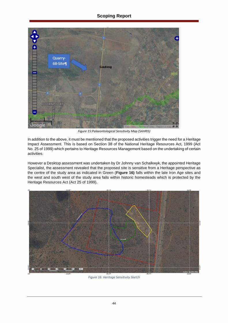
Scoping Report
44
Figure 15:Palaeontological Sensitivity Map (SAHRIS)
In addition to the above, it must be mentioned that the proposed activities trigger the need for a Heritage
Impact Assessment. This is based on Section 38 of the National Heritage Resources Act, 1999 (Act
No. 25 of 1999) which pertains to Heritage Resources Management based on the undertaking of certain
activities.
However a Desktop assessment was undertaken by Dr Johnny van Schalkwyk, the appointed Heritage
Specialist, the assessment revealed that the proposed site is sensitive from a Heritage perspective as
the centre of the study area as indicated in Green (Figure 16) falls within the late Iron Age sites and
the west and south west of the study area falls within historic homesteads which is protected by the
Heritage Resources Act (Act 25 of 1999).
Figure 16: Heritage Sensitivity Sketch
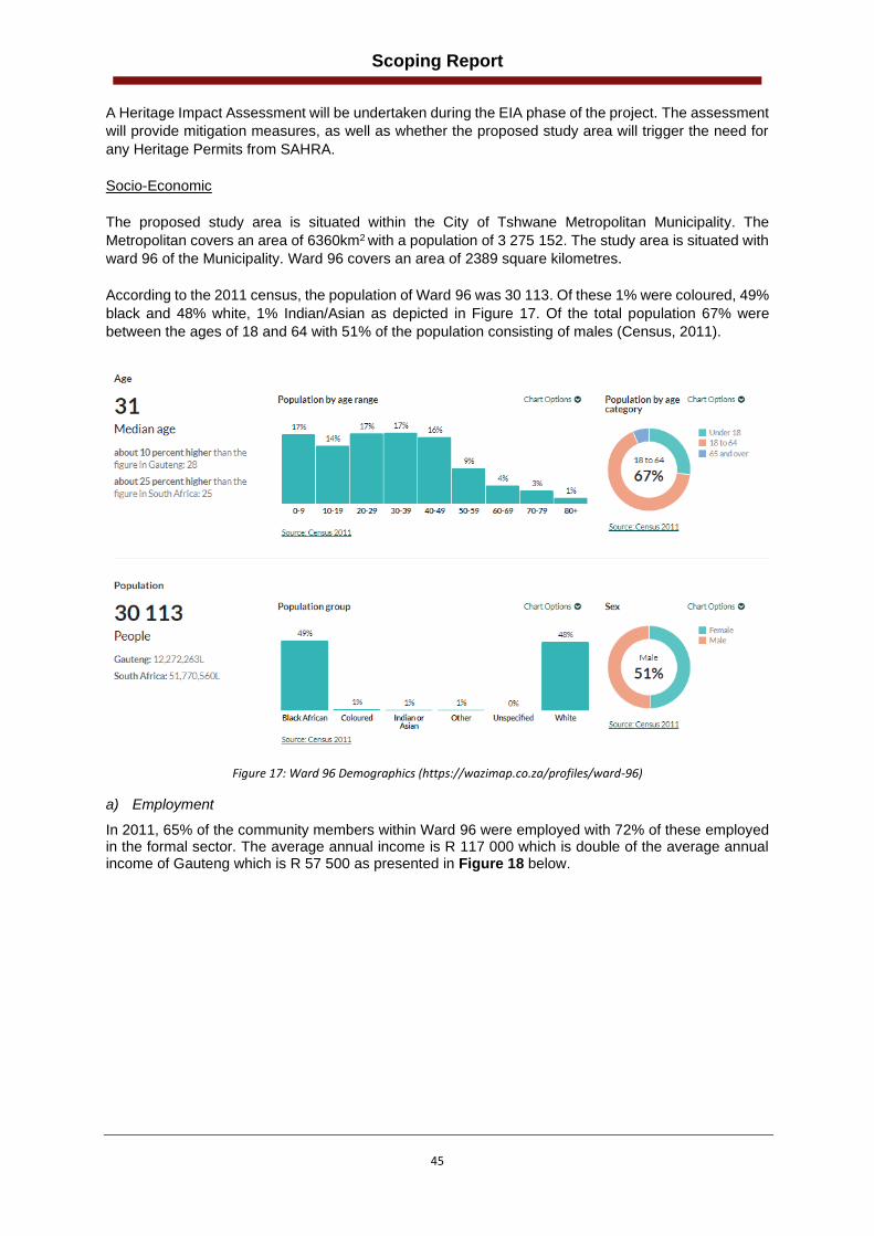
Scoping Report
45
A Heritage Impact Assessment will be undertaken during the EIA phase of the project. The assessment
will provide mitigation measures, as well as whether the proposed study area will trigger the need for
any Heritage Permits from SAHRA.
Socio-Economic
The proposed study area is situated within the City of Tshwane Metropolitan Municipality. The
Metropolitan covers an area of 6360km2 with a population of 3 275 152. The study area is situated with
ward 96 of the Municipality. Ward 96 covers an area of 2389 square kilometres.
According to the 2011 census, the population of Ward 96 was 30 113. Of these 1% were coloured, 49%
black and 48% white, 1% Indian/Asian as depicted in Figure 17. Of the total population 67% were
between the ages of 18 and 64 with 51% of the population consisting of males (Census, 2011).
Figure 17: Ward 96 Demographics (https://wazimap.co.za/profiles/ward-96)
a) Employment
In 2011, 65% of the community members within Ward 96 were employed with 72% of these employed in the formal sector. The average annual income is R 117 000 which is double of the average annual income of Gauteng which is R 57 500 as presented in Figure 18 below.

Scoping Report
46
Figure 18: Ward 96 Employment and Income Statistics (https://wazimap.co.za/profiles/ward-96)
b) Service Delivery
Ninety-two (76.8%) of households obtain water from a regional or local service provider, 19% from a borehole, and the remainder from other sources (Figure 19).
Figure 19: Ward 96 Housing and Service Delivery
Approximately 81% have access to flush or chemical toilets whilst 3.5% of the population have no
access to toilets.

Scoping Report
47
(b) Description of the current land uses.
The study area, which is 44 hectares (ha) in extent, and comprises of mostly undeveloped land located
within a rural setting characterised by agricultural holdings. The site is currently used for cattle grazing,
with remnants of a previous Quarry which was established between 2001 and 2002 on the north eastern
side of the study area. The depleted Quarry still remains as a large depression of approximately 7.1
hectares exists. The road infrastructure within the area is poorly developed and comprises of
unsurfaced roads. The Roodeplaat dam is situated approximately 18km east of the proposed study
area with the N1 that borders the site to the east. It is important to note that during discussions between
the property owner and KBK Engineers regarding the land acquisition process, the landowner advised
that a prospecting right application was in progress with the Department of Mineral Resources and
Energy for the proposed development to mine Vanadium. The applicant is however a privately owned
company.
(c) Description of specific environmental features and infrastructure on
the site. Refer to the sensitivity map (Figure 20) which shows sensitive environmental features within the study
area. During the EIA phase of the project specialist assessment will be conducted whereby this section
of the report will be updated.
Figure 20: Environmental Sensitivity Map
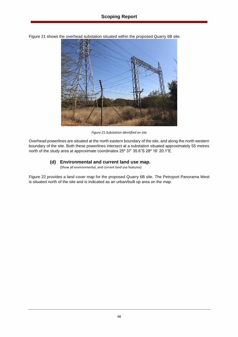
Scoping Report
48
Figure 21 shows the overhead substation situated within the proposed Quarry 6B site.
Figure 21:Substation identified on site
Overhead powerlines are situated at the north eastern boundary of the site, and along the north western
boundary of the site. Both these powerlines intersect at a substation situated approximately 55 metres
north of the study area at approximate coordinates 25º 37’ 35.6”S 28º 16’ 20.1”E.
(d) Environmental and current land use map. (Show all environmental, and current land use features)
Figure 22 provides a land cover map for the proposed Quarry 6B site. The Petroport Panorama West
is situated north of the site and is indicated as an urban/built up area on the map.

Scoping Report
49
Figure 22:Land Cover Map
The proposed site is characterised by woodland and thicket bushveld, bush clumps and high fynbos
vegetation land cover.
(v) Impacts identified (Provide a list of the potential impacts identified of the activities described in the initial site layout that will be
undertaken, as informed by both the typical known impacts of such activities, and as informed by the consultations
with affected parties together with the significance, probability and duration of the impacts
The potential impacts that have been identified in the Scoping Phase of the project are provided below.
These impacts will be further assessed during the EIA phase of the project:
• Loss of floral habitat and species diversity;
• Loss of faunal habitat and species diversity;
• Potential loss of land capability and soil contamination;
• Potential ground and surface water contamination;
• Impacts on wetland/drainage line;
• Potential increase in noise levels;
• Potential increase in dust levels;
• Visual intrusion;
• Increase of traffic on local roads;
• Loss and cultural and heritage resources;
• Increase in waste; and
• Positive impact on job creation.
(vi) Methodology used in determining the significance of environmental impacts (Describe how the significance, probability, and duration of the aforesaid identified impacts that were identified
through the consultation process was determined in order to decide the extent to which the initial site layout needs
revision).

Scoping Report
50
In accordance with the NEMA EIA regulations (Government Notice R.982, promulgated in terms of Section 24 of the National Environmental Management Act, 1998 (Act 107 of 1998)), as amended the Environmental Assessment Practitioner (EAP) is required to assess the significance of potential impacts in terms of the following criteria as outlined in Appendix 1:
• cumulative impacts;
• nature, significance and consequences of the impact and risk;
• extent and duration of the impact and risk;
• probability of the impact and risk occurring;
• the degree to which the impact and risk can be reversed;
• the degree to which the impact and risk may cause irreplaceable loss of resources; and
• the degree to which the impact and risk can be avoided, managed, or mitigated.
Activities within the framework of the proposed development and their respective construction and operational phases, give rise to certain impacts. For the purpose of assessing these impacts, the project has been divided into three phases from which impacting activities can be identified, namely:
Construction phase: This phase refers to all the pre-construction and construction related activities on site, until the contractor leaves the site.
Operational phase: This includes all post construction activities, including the operation and maintenance of the proposed development. The assessment of the impacts will be conducted according to a synthesis of criteria required by the integrated environmental management procedure. The methodology that will be used comprises of the following four steps:
• Step 1: Identification of positive and negative impacts of the project;
• Step 2: Identification of the significance rating of the impact before mitigation;
• Step 3: Identification of the mitigation measure and the mitigation efficiency; and
• Step 4; Identification of the significance rating of the impact after mitigation;
Activities that will be undertaken to give effect to the proposed development gives rise to certain impacts. For the purpose of assessing these impacts, the project has been divided into the following phases discussed in Table 8.
Table 8: Project phases in a development
PHASES OF A PROJECT IN WHICH IMPACTS WILL OCCUR
• Status Quo
The study area as it currently exists.
• Pre-construction phase
All activities on site up to the start of construction, not including the transport of materials, but including the initial site preparations. This also includes the impacts that would be associated with planning.
• Construction phase
All the construction and construction-related activities on site, until the contractor leaves the site.
• Operational phase
All activities after construction, including the operation of the Quarry.
The activities arising from each of the relevant phases have been included in the impacts assessment tables. The assessment endeavours to identify activities that would require environmental management actions to mitigate the impacts arising from them. The criteria against which the activities were assessed are given in the next section.

Scoping Report
51
Assessment Criteria
The assessment of the impacts will be conducted according to a synthesis of criteria required by the guideline documents to the EIA regulations (2006) and integrated environmental management series published by the Department of Environmental Affairs and Tourism (DEAT) currently DEFF. In addition to this, it is a requirement of (NEMA 2014 Regulations (as amended), Appendices 1 and 2 that an Impact and Risk Assessment process be undertaken for Basic Assessments and Environmental Impact Reporting. The Assessment Criteria is based on the following:
• Nature of Impact,
• Extent;
• Duration;
• Intensity;
• Probability;
• Determination of significance; and
• Reversibility of impact. Each of these is explained in Table 9.
Table 9: Methodology used in rating impacts of a project
ASSESSMENT CRITERIA
a) Nature of Impact
This is an appraisal of the type of effect the proposed activity would have on the affected environmental component. The description should include what is being affected, and how.
b) Extent
The physical and spatial size of the impact. This is classified as: i) Site
The impact could affect the whole, or a measurable portion of the site. ii) Local
The impacted area extends only as far as the activity, e.g. a footprint of the specific activity iii) Regional
The impact could affect areas such as neighbouring farms, transport corridors and the adjoining towns.
c) Duration
The lifetime of the impact; this is measured in the context of the lifetime of the proposed project.
• Short term The impact will either disappear with mitigation or will be mitigated through natural process in a span shorter than any of the phases.
ii) Medium term The impact will last up to the end of the phases, whereafter it will be entirely negated.
iii) Long term The impact will continue or last for the entire operational life of the development but will be mitigated by direct human action or by natural processes thereafter.
iv) Permanent The only class of impact which will be non-transitory. Mitigation either by man or natural processes will not occur in such a way or in such a time span that the impact can be considered transient.
d) Intensity
Is the impact destructive or benign? Does it destroy the impacted environment, alter its functioning, or slightly alter it? These are rated as:
i) Low The impact alters the affected environment in such a way that the natural processes or functions are not affected.
ii) Medium (Moderate) The affected environment is altered, but function and process continue, albeit in a modified way.
iii) High Function or process of the affected environment is disturbed to the extent where it temporarily or permanently ceases. This will be a relative evaluation within the context of all the activities and the other impacts within the framework of the project.
e) Probability

Scoping Report
52
This describes the likelihood of the impacts actually occurring. The impact may occur for any length of time during the life cycle of the activity, and not at any given time. The classes are rated as follows:
i) Improbable The possibility of the impact occurring is very low, due either to the circumstances, design, or experience.
ii) Probable There is a possibility that the impact will occur to the extent that provisions must be made.
iii) Highly probable It is most likely that the impacts will occur at some or other stage of the development. Plans must be drawn up before the undertaking of the activity.
iv) Definite The impact will take place regardless of any prevention plans, and mitigation actions or contingency plans are relied on to contain the effect.
f) Determination of significance
Significance is determined through a synthesis of impact characteristics. Significance is an indication of the importance of the impact in terms of both physical extent and time scale, and therefore indicates the level of mitigation required. The classes are rated as follows:
i) No significance The impact is not substantial and does not require any mitigation.
ii) Low The impact is of little importance but may require limited mitigation.
iii) Medium (Moderate) The impact is of importance and therefore considered to have a negative impact. Mitigation is required to reduce the negative impacts to acceptable levels.
iv) High The impact is of great importance. Failure to mitigate, with the objective of reducing the impact to acceptable levels, could render the entire development option or entire project proposal unacceptable.
g) Reversibility of impact
Natural or human aided intervention: (i) Irreversible
The impact will be permanent. (ii) Short term
The impact is reversible within two years after construction. (iii) Long term
The impact is reversible within 2 to 10 years after construction.
f) The degree to which the impact can cause irreplaceable loss of resources
(i) Low The impact result in the loss of resources but the natural, cultural, and social processes/functions are not affected.
(ii) Medium The loss of resources occurs but natural cultural and social processes continue, albeit in a modified manner.
(iii) High The impact result in irreplaceable loss of resource.

Scoping Report
53
(vii) The positive and negative impacts that the proposed activity (in terms of the initial site layout) and alternatives will have
on the environment and the community that may be affected (Provide a discussion in terms of advantages and disadvantages of the initial site layout compared to alternative layout options to accommodate concerns raised by affected parties)
Table 10: Positive and Negative Impacts Associated with Quarry 6B
Environmental Aspect
Project Phase Potential Impact Impact (Positive/Negative
Fauna Construction/ Operation
• Clearing of vegetation and fencing of the study are can result in disruption of the faunal habitat;
• Fencing of the Quarry area could limit movement of faunal species;
• Movement of construction vehicles and mining activities (noise and dust) could adversely affect fauna in terms of los of species diversity; and
• Loss of species diversity
Negative
Flora Construction / Operation
• Loss of floral species diversity may take place during the construction and operational phases of the project as a result of initial clearing of vegetation during site establishment and preparing surface areas for excavation activities and stockpiling;
• Initial clearing of vegetation during site establishment and preparing surface areas for excavation activities and stockpiling; and
• Clearance of vegetation for construction activities may result in proliferation of alien and invasive floral species may outcompete certain species.
Negative
Soils and land Capability
Construction • The commissioning of a Quarry on the proposed site can result in loss of land use for cattle farming;
Negative
Operation • Potential disturbance on soil includes compaction owing to vehicle traffic and increased surface runoff from the compacted areas;
• Soil pollution may emanate from petroleum hydrocarbon contamination owing to vehicle and machinery breakdown;
• The proposed construction of the Quarry will require the clearance of vegetation and stripping of topsoil resulting in the loss of the original spatial distribution of the natural soil forms and horizon sequences.
• Loss of topography and drainage patterns.
Negative

Scoping Report
54
Surface Water Construction/operation • Surface water runoff due to mining activities can result in soil erosion and impact surface water quality.
• The compaction of soil and the clearing of vegetation during the operational and construction phase will result increased surface runoff and soil erosion.
Negative
Groundwater Construction/Operation • Potential contamination of groundwater due to spillages and leaks of hazardous substances, improper stormwater management, and fuel/oil leaks from vehicles during the operation of the Quarry;
• Potential use of groundwater for mining operations could lower the levels of the aquifer;
• Impact of the geology during the mining operations could potentially disturb the flow patterns of the groundwater.
Negative
Wetland/Drainage Line
Construction/Operation • Changing the amount of sediment entering the water resource and associated change in turbidity (increasing or decreasing the amount) due to the haulage vehicles;
• Operational activities may result in the discharge of solvents, leakage of fuel/oil from vehicles resulting in the loss of sensitive biota in the wetland and a reduction in watercourse function.
Negative
Air Quality Construction • Emissions will be generated during site clearing (removal of vegetation);
• Movement of vehicles and site establishment; and
• Undertaking of a baseline survey of dust fall.
Negative
Operation • Decrease in the air quality due to particulate emissions from blasting activities, screening, and material handling,
• Vehicle movement on unsurfaced haul roads resulting in dust emissions and release of carbon emissions
• Wind erosion on exposed areas; and
• Increase in traffic on the local road networks resulting in increased air emissions
Negative
Noise Construction • Activities undertaken during the construction/establishment of the Quarry will generate noise
Negative
Operation • Noise will be generated from the blasting and crushing activities undertaken.
• Noise generation as a result of haulage vehicles •
Negative
Traffic Construction/Operation • Increase in traffic on the local road networks to due haulage; Negative

Scoping Report
55
Visual Construction/Operation Operation
• Reduction in visual quality due to the removal of vegetation;
• During the construction phase of the project it is anticipated that construction vehicles in the area as well as excavations will have a potentially negative impact on the surrounding land use;
• The placement of stockpiles could result in visual intrusion on the adjacent landowners;
Negative
Cultural and Heritage
Construction/Operation Operation
• Risk of heritage and cultural resources being damaged / destroyed through mining activities.
Negative
Waste Management
Construction • The Clearing of site will result in waste generation (vegetation); Negative
Operation • Building and domestic waste will be generated during the operation of the Quarry
• Littering and improper waste storage may attract vermin resulting in a negative visual appeal of the area;
• Improper disposal of hazardous waste (e.g. chemicals, oils, soil contaminated by spillages, diesel rags).
Negative
Socio-economic Environment
Construction • Temporary loss of existing land use through clearance of mining areas;
• Temporary use of local road network by delivery and haul vehicles;
• Damage to existing infrastructure e.g., fences, water hole etc
• Population influx due to job seekers to the area which could pose a number of risks to the local community; and
• Creation of local employment and business opportunities.
Negative
Operation • The mining of the Quarry will result in road material for the upgrading of the R573 and upgrades of local link roads resulting in improved road safety, improved mobility, improved access, and promotion of future land use development in the area;
• Proposed development would create a number of local employment and business opportunities during operation;
• Opportunity for skills development and on-site training;
Positive
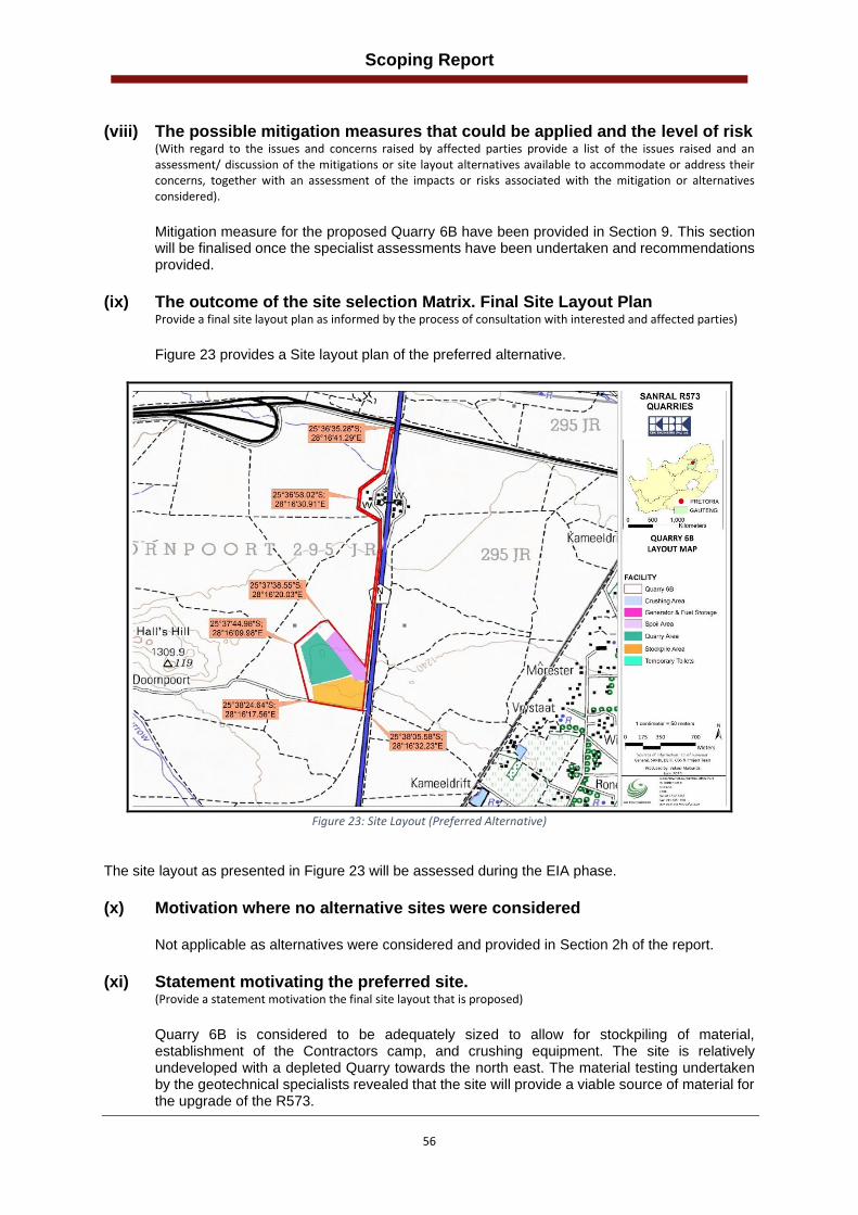
Scoping Report
56
(viii) The possible mitigation measures that could be applied and the level of risk
(With regard to the issues and concerns raised by affected parties provide a list of the issues raised and an assessment/ discussion of the mitigations or site layout alternatives available to accommodate or address their concerns, together with an assessment of the impacts or risks associated with the mitigation or alternatives considered).
Mitigation measure for the proposed Quarry 6B have been provided in Section 9. This section will be finalised once the specialist assessments have been undertaken and recommendations provided.
(ix) The outcome of the site selection Matrix. Final Site Layout Plan
Provide a final site layout plan as informed by the process of consultation with interested and affected parties)
Figure 23 provides a Site layout plan of the preferred alternative.
Figure 23: Site Layout (Preferred Alternative)
The site layout as presented in Figure 23 will be assessed during the EIA phase.
(x) Motivation where no alternative sites were considered
Not applicable as alternatives were considered and provided in Section 2h of the report.
(xi) Statement motivating the preferred site.
(Provide a statement motivation the final site layout that is proposed)
Quarry 6B is considered to be adequately sized to allow for stockpiling of material, establishment of the Contractors camp, and crushing equipment. The site is relatively undeveloped with a depleted Quarry towards the north east. The material testing undertaken by the geotechnical specialists revealed that the site will provide a viable source of material for the upgrade of the R573.

Scoping Report
57
(xii) Plan of study for the Environmental Impact Assessment process
1. Description of alternatives to be considered including the option of not going ahead with the activity.
Refer to Section 2h for a description of the alternatives that have been considered.
2. Description of the aspects to be assessed as part of the environmental
impact assessment process (The EAP must undertake to assess the aspects affected by each individual mining activity whether listed or not, including activities such as blasting, Loading, hauling and transport, and mining activities such as Excavations, stockpiles, discard dumps or dams, water supply dams and boreholes, accommodation, offices, ablution, stores, workshops, processing plant, storm water control, berms, roads, pipelines, power lines, conveyors, etc…etc…etc.).
An aspect is anything (activity, development, element etc.) that can bring about impacts. The following environmental aspects have been identified by the EAP, and could potentially cause impacts during the construction and operational phase of the project:
• Soils Land Use Land Capability;
• Terrestrial Ecology;
• Surface water;
• Groundwater;
• Wetland/drainage line;
• Air Quality;
• Cultural and Heritage;
• Visual Environment;
• Social Environment;
• Waste Management;
• Traffic and Safety; and
• Noise impacts. The above-mentioned aspects will be further assessed during the EIA phase of the project.
3. Description of aspects to be assessed by specialists
Terrestrial Biodiversity Assessment Desktop studies indicate that the central portion of the study area is indicated to be associated with a CBA and the area along its northern boundary is indicated to fall within an ESA. An area of more than 20 hectares will be cleared in order to accommodate the proposed Quarry. A Terrestrial Biodiversity Assessment will be undertaken to assess the potential impacts that may occur as a result of the proposed project and to provide site specific mitigation measures and ongoing management measures that will be required to reduce such impacts should the project be approved. The Terms of Reference for the Terrestrial Biodiversity Assessment include the following:
• To provide an overview of applicable environmental legislation as well as national and regional planning guidelines to be considered in planning the project;
• To provide a broad description of the biophysical characteristics of the project area and their surroundings as applicable to the terrestrial biodiversity assessment;
• To categorise and describe the vegetation and habitat present within the project area according to relatively homogeneous habitat units and to provide an overview of vegetation structure, floral species composition (including alien species), faunal associations and species diversity of each habitat unit;

Scoping Report
58
• To identify floral and faunal Species of Conservation Concern (SCC) that could potentially occur in the project area and surrounds, to confirm their presence where possible and to identify whether suitable habitat for such species is available;
• To provide an indication of the conservation importance and ecological sensitivity of each habitat unit identified within the project area and to identify No Go areas where applicable; and
• To assess the potential impacts that may occur as a result of the proposed project and to provide site-specific mitigation measures and ongoing management measures that will be required to reduce such impacts should the project be approved;
• Provide rehabilitation measures for the rehabilitation phase of the proposed Quarry Wetland and Aquatic Assessment According to the SANBI data set National Freshwater Ecosystem Priority Area (NFEPA) wetlands were present towards the south east of the site. The Terms of Reference for the Wetland Assessment include the following:
• Delineate the wetland and riparian areas;
• Classify the watercourse according to the system proposed in the national wetlands inventory if relevant,
• Undertake functional and integrity assessment of wetlands areas within the area assessed as specified in General Notice 267 of 24 March 2017;
• Undertake an impact assessment as specified in the NEMA 2014 regulations,
• Undertake a risk assessment as specified in General Notice 509 in published in the Government Gazette 40713 of 24 March 2017,
• Recommend suitable buffer zones, both generic (as required in GDARD, 2014) and scientific as specified in General Notice 267 of 24 March 2017, following Macfarlane et al 2015; and
• Discuss appropriate mitigation and management procedures relevant to the conserving wetland areas on the site;
• Rehabilitation plan/measures for the wetland. Heritage Impact Assessment The proposed activities trigger the need for a Heritage Impact Assessment. This is based on Section 38 of the National Heritage Resources Act, 1999 (Act No. 25 of 1999). The Terms of Reference for the Heritage Impact Assessment include the following:
• Undertaking of a Desktop Assessment to obtain background information regarding the know Heritage resources with the proposed development site;
• Identifying of possible archaeological, cultural, and historic sites within the proposed development area during the site assessment;
• Evaluate the potential impacts of construction, operation, and maintenance of the proposed development on archaeological, cultural, and historical resources;
• Recommend mitigation measures to ameliorate any negative impacts on areas of archaeological, cultural, or historical importance; and
• Identifying key uncertainties and risks.
4. Proposed method of assessing the environmental aspects including the
proposed method of assessing alternatives Please refer to Section vi regarding the Methodology used in determining the significance of
environmental impacts.
5. The proposed method of assessing duration significance Please refer to Section vi regarding the Methodology used in determining the significance of environmental impacts.

Scoping Report
59
6. The stages at which the competent authority will be consulted The competent authority for the proposed Quarry is the Department of Mineral Resources and Energy (DMRE). The DMRE has already been consulted and will be consulted during the following stages of the Scoping and EIA Process (Figure 24). Pre-Application Meeting A pre-consultation meeting was held with the DMRE on the 24th of January 2020 to confirm the authorisation requirements. The attendance registers and the minutes of the meeting are provided in Appendix E of this report. Scoping Phase The application for Environmental Authorisation and the Draft Scoping report will be submitted to the DMRE for review and comment (30-day legislated comment period). Once the 30-day comment period has lapsed and the DMRE has provided their comments on the Draft Report, the Final Scoping report will be submitted to the DMRE. The Draft scoping report will be submitted with the Scoping/EIA Application form and a Reference Number will be issued. EIA Phase The draft EIA report will be compiled and submitted to the DMRE after receiving approval from DMR on the FSR, as per the 2014 EIA Regulations (as amended).
The process that will be followed is diagrammatically presented in Figure 21.

Scoping Report
60
Figure 24: Scoping and EIA Process
7. Particulars of the public participation process with regard to the Impact Assessment process that will be conducted a) Steps to be taken to notify interested and affected parties
(These steps must include the steps that will be taken to ensure consultation with the affected parties identified in (h) (ii) herein).
Public participation during the EIA phase will continue similarly to the process undertaken for the Scoping Phase. The key tasks that will form part of the public participation process in the EIA phase include:
• Ongoing identification of I&APs;
• Placement of the Draft EIA Report for public comment;
• Continued consultation within key stakeholders and I&APs; and

Scoping Report
61
• Continued recording of issues and responses.
b) Details of the engagement process to be followed. (Describe the process to be undertaken to consult interested and affected parties including public meetings and one on one consultation. NB the affected parties must be specifically consulted regardless of whether or not they attended public meetings and records of such consultation will be required in the EIA at a later stage).
Refer to Section 7a which provides details of the engagement process to be undertaken.
c) Description of the information to be provided to Interested and
Affected Parties. (Information to be provided must include the initial site plan and sufficient detail of the intended operation and the typical impacts of each activity, to enable them to assess what impact the activities will have on them or on the use of their land).
Section 7a provides a detailed description of the Public Participation process that has/will be undertaken:
• A Notification Letter has been compiled and distributed electronically and door to door to adjacent landowners and potentially affected Interested and Affected Parties. The document provided a background on the project, the proposed activities, including a locality map showing the site boundaries as well as information on how one can register as an Interested and Affected Party (I&AP) on the project in order to be able to be kept abreast of all developments;
• This Draft Scoping report has been made available for public review. The report will be
placed at a public venue within close proximity of the proposed development, which is
dependent on the COVID 19 directions issued at the time by the Minister of Environment,
Forestry and Fisheries. An electronic version of the report will also be made available to the
public by providing them with a Uniform Resource Locator (URL) link where the report can
be downloaded;
• The draft EIR/EMP will be made available for public review and comments including all specialist assessments undertaken for the proposed project.
8. Description of the tasks that will be undertaken during the environmental
impact assessment process In order to adequately assess and provide sufficient responses to the issues raised during the Scoping Phase, the following tasks will be undertaken during the EIA Phase:
• Reviewing the approval for the Scoping and Plan of Study for EIA including the relevant conditions of approval;
• Ongoing public participation;
• Undertaking of specialist investigations on all the significant issues identified and raised in the Scoping Process;
• Evaluate and summarise the findings of the specialist reports;
• Undertaking a detailed impact assessment process, assessing alternatives, and providing potential mitigation measures;
• Documenting the findings of the Impact Assessment into an Environmental Impact Report (EIR); and
• Compiling an Environmental Management Programme.

Scoping Report
62
9. Measures to avoid, reverse, mitigate, or manage identified impacts and to determine the extent of the residual risks that need to be managed and monitored.
Table 11: Mitigations Measures to Manage Identified Impacts
ACTIVITY Whether listed or not listed. (E.g. Excavations, blasting, stockpiles, discard dumps or dams, Loading, hauling and transport, Water supply dams and boreholes, accommodation, offices, ablution, stores, workshops, processing plant, storm water control, berms, roads, pipelines, power lines, conveyors,
etc…etc…etc.).
POTENTIAL IMPACT (E.g. dust, noise, drainage surface disturbance, fly rock, surface water contamination, groundwater contamination, and air pollution etc….etc.…)
MITIGATION TYPE (modify, remedy, control, or stop) through (e.g. noise control measures, storm-water control, dust control, rehabilitation, design measures, blasting controls, avoidance, relocation, alternative activity etc. etc.) E.g. Modify through alternative method. Control through noise control Control through management and monitoring through rehabilitation.
POTENTIAL FOR RESIDUAL RISK
Clear and Grub, Mining Activities, Civil Work
• Loss of Flora • Amount of vegetation, particularly indigenous vegetation cleared should be limited to only what is required.
• All permanent and temporary project infrastructure should avoid areas of increased ecological sensitivity as far as possible.
• Construction vehicles should be restricted to travelling only on designated roadways, to limit the ecological footprint of the proposed development activities;
• The site shall be rehabilitated as far as possible to its natural state after construction
Medium
Clear and Grub, Mining Activities, Civil Work
• Loss of Fauna • No areas should be cleared of natural vegetation if not required for construction and operational purposes of the quarries and borrow pits;
• All permanent and temporary project infrastructure should avoid areas of increased ecological sensitivity as far as possible.
• Construction vehicles should be restricted to travelling on designated roadways only and vehicle access beyond the designated project footprint areas should be prohibited to minimize/avoid faunal mortalities.
• No wild animals may under any circumstance be handled, removed, or be interfered with by construction workers.
Medium
Site Establishment and infrastructure establishment
• Loss of soil resources and land capability through pollution and physical disturbance
• Topsoil should be excavated and stockpiled separately from the subsoils to be used during the rehabilitation;
• Drip trays shall be provided in construction areas for stationary plant and for "parked" plant; Drip trays, sumps and bunds must be emptied regularly, especially before a
Low

Scoping Report
63
known rain event and after a rain event, and the contents disposed of at a licensed disposal facility;
• All vehicles and equipment shall be kept in good working order and serviced regularly; Leaking equipment shall be repaired immediately or removed from the Site;
• A stormwater management plan, must be compiled and implemented by the Contractor to take the increased surface water run-off rates and volumes and their erosion potential into consideration
Clear and Grub, Mining Activities, Crushing, Civil Work
• Impact on heritage and cultural resources
• Should any graves be uncovered during the construction phase of the project, the applicant and appointed ECO must ensure in terms of section 38(6) of the Act, the responsible heritage resources authority as well as the South African Police Service (SAPS) are informed;
• The ECO must train the Contractor to recognise any heritage features. Should there be a sign of such objects, construction must halt in that area immediately and a suitably qualified heritage specialist must be called to investigate through the ECO
Low
Clear and Grub, Mining Activities, Crushing, Civil Work
• Pollution of surface water resources
• Roads should be kept in serviceable condition to minimise erosion by rainfall runoff and vehicle use
• A stormwater management plan, must be compiled and implemented by the Contractor to take the increased surface water run-off rates and volumes and their erosion potential into consideration
• A surface water pollution prevention plan shall be compiled and implemented by the contractor
• Use bund for temporary storing of hazardous waste.
Low
Blasting, crushing and operation of machinery
• Noise Pollution • The size of explosive charges used for blasting (if required) should be optimised so as to balance breaking capacity against minimising any vibration impact and fly-rock;
• Survey potentially affected structures prior to and after blasting;
• Adjacent landowners and businesses must be notified well in advance about blasting activities and appropriate precautionary measures must be taken;
• All construction plant and other equipment must be in a good working order to reduce possible noise pollution;
• The contractor shall implement a blast management plan; and
• The Contractor shall employ industry standard methods to control the impact of blasting and limit the risk of damage to
Low

Scoping Report
64
buildings and structures by reducing blast vibrations induced in the rock mass, eliminating fly rock and limiting air-blast and noise to acceptable levels; and
• Undertake excavations, blasting and crushing only after 06:00 in the morning and before 18:00 in the evening. No work allowed on Sundays.
Blasting, crushing and operation of machinery’ Quarry Operation
• Air Quality • Implement dust suppression measures in all areas that will be affected by construction activities and where dust will be generated. Dust suppression must also be undertaken during windy and dry weather conditions;
• A continuous dust monitoring process needs to be undertaken during construction/operation;
• Restrict the project footprint to only what is required;
• Stockpiles shall be protected from wind erosion;
• Heavy vehicles and machinery should be serviced regularly to minimise exhaust fume pollution;
Low
Haulage of Material and transportation
• Traffic Impact • A traffic management plan shall be compiled and implemented by the Contractor;
• The number of haulage vehicles shall be controlled per day.
Low
Haulage of Material and transportation
• Wetland/drainage line
• Ensure that the current access road has sufficient stormwater infrastructure to prevent input of high energy runoff into the wetland;
• Prevent sediment washing from the road into the adjacent wetland. Construct a small berm next to the haul road to prevent sediment from entering the wetland.;
• Material on haulage vehicles shall be restricted to a maximum height.
Low
Establishment of the quarry
• Influx of job seekers
• Employment and procurement opportunities provided to identified communities
Low
Operation of the Quarry
• Creation of employment and business opportunities
• The Contractor must ensure that the recruitment process is conducted through the community structures established for the contract.
Low
Material Stockpiles, Quarry operations & Transportation
• Visual • Develop material stockpiles only in areas designated on the site plan
• Ongoing clearing of alien invasive vegetation in the disturbed areas associated with the works
• Reinstatement and rehabilitation of disturbed areas with vegetation as per the rehabilitation plan or as soon as particle.
Low

Scoping Report
65
Mining activities, operation of the quarry
• Waste generation • A waste management plan shall be compiled and implemented by the Contractor. Waste hierarchy principals-reduce, re-use, recycle shall be implemented. Recyclable waste must be kept separate from general waste and taken to a waste recovery / recycling facility
• Adequate storage facilities for general and hazardous waste;
• Waste receptables with lids (i.e. weather and vermin proof) for management of waste on site
• Hazardous waste shall be stored in a bund wall. Disposal of all hazardous waste at a hazardous waste landfill
• General waste shall be disposed at a landfill at least weekly, or more frequently if required
Low
(xiii) Other Information required by the competent Authority
1. Compliance with the provisions of sections 24(4) (a) and (b) read with section 24 (3) (a) and (7) of the National Environmental Management Act (Act 107 of 1998). the EIA report must include the:-
a) Impact on the socio-economic conditions of any directly affected
person. (Provide the results of Investigation, assessment, and evaluation of the impact of
the mining, bulk sampling or alluvial diamond prospecting on any directly affected person including the landowner, lawful occupier, or, where applicable, potential beneficiaries of any land restitution claim, attach the investigation report as Appendix 2.19.1 and confirm that the applicable mitigation is reflected in 2.5.3; 2.11.6.and 2.12.herein).
The proposed Quarry will be utilised for the upgrading of the R573 Moloto Road and associated link roads. The R573 Moloto Road is one of South Africa’s busiest and most important economic routes connecting Gauteng, Mpumalanga, and Limpopo provinces with an extremely high number of buses and light motor vehicles. The road links small towns and rural settlements with the City of Tshwane and carries inter-district traffic between these locations, hence the road is an important regional mobility function but has an equally significant accessibility function (KBK Engineers, 2020). Should the R573 Moloto Road not be maintained, there will be negative impact on the people, their safety and their livelihoods, furthermore vehicular wear and tear and maintenance results in higher living costs. The approval/commissioning of the proposed Quarry will allow for the proposed Moloto Road Upgrade that will benefit not only local communities and residents but also all road users. In terms of local community upliftment, SANRAL has procedures in place in accordance with National Treasury regulations and requirements. Community Development Projects (CDPs) will be identified and included within the larger project, which will include works for smaller contractors. Contract Participation Goal (CPG) targets will be applicable to the proposed project, which will require the Contractor to utilize local labour, sub-contractors and suppliers relative to the total Contract value. The proposed Quarry 6B operations will result in temporary increase in noise and dust levels on the adjacent landowners, these potential impacts will be assessed during the EIA phase of the project.
b) Impact on any national estate referred to in section 3(2) of the National Heritage Resources Act. (Provide the results of Investigation,
assessment, and evaluation of the impact of the mining, bulk sampling or alluvial diamond prospecting on any national estate referred to in section 3(2) of the National Heritage Resources Act, 1999 (Act No. 25 of 1999) with the exception of the national estate contemplated in section 3(2)(i)(vi) and (vii) of that Act, attach the investigation report as

Scoping Report
66
Appendix 2.19.2 and confirm that the applicable mitigation is reflected in 2.5.3; 2.11.6.and 2.12.herein).
A Heritage Impact Assessment (HIA) will be undertaken as part of the EIA phase of the project. The HIA will be made available to the DMRE as an Appendix to the draft EIA report.
(xiv) Other matters required in terms of sections 24(4)(a) and (b) of the Act.
(the EAP managing the application must provide the competent authority with detailed, written proof of an investigation as required by section 24(4)(b)(i) of the Act and motivation if no reasonable or feasible alternatives, as contemplated in sub-regulation 22(2)(h), exist. The EAP must attach such motivation as Appendix 4).
Not applicable as alternatives have been assessed.

Scoping Report
67
(xv) UNDERTAKING REGARDING CORRECTNESS OF INFORMATION
I Kirthi Peramaul herewith undertake that the information provided in the foregoing report is correct, and that the comments and inputs from stakeholders and Interested and Affected parties has been correctly recorded in the report.
__________________ Signature of the EAP DATE:
(xvi) UNDERTAKING REGARDING LEVEL OF AGREEMENT
I Kirthi Peramaul herewith undertake that the information provided in the foregoing report is correct, and that the level of agreement with interested and Affected Parties and stakeholders has been correctly recorded and reported herein.
____________ Signature of the EAP DATE:
-END-