r s uta Æi ou city of / ville de ais gatineau tawa iver · transport en commun rapide par autobus...
TRANSCRIPT
!(!(
!(!(!(
!(
!(
!(
!(
!(
!(
!(
!(
!(
!( !( !( !( !(
!(
!(
!(
!(
!(
!(
!(
!(
!(
!( !(
!(
!(!(!(
!(!(!(!(!(
!(!(
!(!(
!(
!(!(
!(
!(
!(
!(
!(!(
!( !( !(
!(!(
!(
!(!(
!(!(!(
!(!(
!(
!(
!( !(
!(
!(
!(
!(!(!(
!(
!(
!(
!(
!(
!(!(
!(
!(!(
!(
!(!(!(!(
!(
!(
!(!(!(!(!(!(!(!(!(
!(
!(
!(
!(
!(
!(
!(
!(!(
!(
!(
!(
!(
!(
!(
!(
!(!(
!(
!( !(!(
!( !( !(!(!(!(!( !(
!(
!(
!(
"S
"S
"S
"S
_̂
Æi Æi
Æi
Æi
Æi
Æi
Æi
ÆiÆi
ÆiÆi
Æi
Æi
ÆiÆi
Æi
Æi
Æi
Æi
Æi
Æi
Æi
Æi
Æi
Æi
Æi
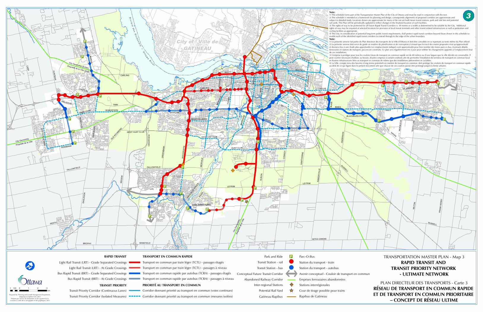
TRANSPORTATION MASTER PLAN - Map 3TRANSPORTATION MASTER PLAN - Map 3RAPID TRANSIT AND RAPID TRANSIT AND
TRANSIT PRIORITY NETWORK TRANSIT PRIORITY NETWORK - ULTIMATE NETWORK- ULTIMATE NETWORK
PLAN DIRECTEUR DES TRANSPORTS - Carte 3PLAN DIRECTEUR DES TRANSPORTS - Carte 3
I
Ri v
i ér e
de
sO
ut a
ou
ai s
/O
t t aw
aR
i v e r
3
Prepared by: Planning and Growth Management Department, Mapping & Graphics Unit, 2013
Préparé par: Service de l'urbanisme et de la gestion de la croissance, Unité de la cartographie et des graphiques, 2013
TRANSIT PRIORITY
RAPID TRANSIT
Abandoned Railway Corridor
Park and Ride Parc-O-Bus
Transit Station - rail
Transit Station - bus
Station du transport - train
Station du transport - autobus
City Ownership (active)Propriété de la Ville (actif)
City Ownership
Propriété de la Ville
City
Ow
ners
hip
Prop
riété
de
la V
ille
Emprises ferrouiaires abandonnées
Conceptual Future Transit Corridor Avenir conceptuel - Couloir de transport en commun
Stations interrégionales
Cour de tirage possible pour trains
Inter-regional Stations
Potential Rail Yard _̂Gatineau Rapibus
!i
RÉSEAU DE TRANSPORT EN COMMUN RAPIDE RÉSEAU DE TRANSPORT EN COMMUN RAPIDE ET DE TRANSPORT EN COMMUN PRIORITAIRE ET DE TRANSPORT EN COMMUN PRIORITAIRE
– CONCEPT DE RÉSEAU ULTIME– CONCEPT DE RÉSEAU ULTIME
Bus Rapid Transit (BRT) - At-Grade Crossings
Bus Rapid Transit (BRT) - Grade Separated Crossings
Light Rail Transit (LRT) - At-Grade Crossings
Light Rail Transit (LRT) - Grade Separated Crossings
Transit Priority Corridor (Continuous Lanes)
Transit Priority Corridor (Isolated Measures)
TRANSPORT EN COMMUN RAPIDE
Transport en commun par train léger (TCTL) - passages étagés
Transport en commun par train léger (TCTL) - passages à niveau
Transport en commun rapide par autobus (TCRA) - passages étagés
Transport en commun rapide par autobus (TCRA) - passages à niveau
PRIORITÉ AU TRANSPORT EN COMMUN
Corridor donnant priorité au transport en commun (voies continues)
Corridor donnant priorité au transport en commun (mesures isolées) Rapibus de Gatineau
1 0 1 2 30.5km
City of / Ville deGATINEAU
5
CAR
P HU
NTM
AR
MA
RC
H
CAMPEAU
PALADIUM
HAZELDEAN
EAG
LES
ON
CARLING
TIMM
ROBERTSON
STITTSV
ILLE M
AIN
FERNBANK
FALLOWFIELD
EAG
LES
ON
TER
RY FO
X
OLD R
ICHMOND
MO
OD
IE
PERTH
BROPHY BANKFIELD
EARL ARMSTRONG
PRIN
CE OF
WAL
ESRIV
ER
LEITRIM
FALLOWFIELD
WEST HUNT CLUB
GR
EE
NBA
NK
WO
OD
RO
FFEC
EDA
RV
IEW
BASELINE
MEADOWLANDS
WEST HUNT CLUB
HUNT CLUB
ME
RIV
ALE
RIV
ERSI
DE
FIS
HE
R
MER
IVAL
E
CARLING
SCOTT
HO
LLA
ND
KIR
KWO
OD
BRO
NSO
N
BAN
K
MA
IN
HEMLOCK
McARTHUR
MONTREAL
OGILVIE
ST L
AU
RE
NT
SMYTH
INDUSTRIAL
BLA
IR
INNES
BLACKBURN BYPASSHERON
WALKLEY
CO
NR
OY
HAW
THO
RN
E
RAM
SAY
VIL
LE
ALB
ION
AND
ER
SO
N
LEITRIM
RUSSELL
MITCH OWENS
RUSSELL
MIL
TON
FRA
NK
KE
NN
Y
ST JOSEPHJEANNE D'ARC
INNES
ORLEANS
NAVAN
TEN
TH L
INE
ME
R B
LEU
E
TRIM
1) This schedule forms part of the Transportation Master Plan of the City of Ottawa and must be read in conjunction with the text.2) This schedule is intended as a framework for planning and design; consequently alignments of proposed corridors are approximate and subject to detailed study. Locations shown are approximate for many of the not yet built future transit stations, park and ride lots and potential rail yards. This Plan will be periodically updated to reflect changes in the finalized location of such facilities.3) The rights-of-way to be protected for all Future Rapid Transit Corridors is 40 metres or a width as determined to be suitable by the City. Additional rights-of-way may be required at selected locations for provision of local transit terminals and other transit related infrastructure as well as pedestrian and cycling facilities as appropriate.4) The City, in consideration of potential long-term public transit requirements, shall protect rapid transit corridors beyond those shown in this schedule to enable each of the identified rapid transit corridors to extend through to the edge of the urban boundary.
1) La présente annexe fait partie du Plan directeur des transports de la Ville d’Ottawa et doit être consultée en se reportant au texte même du Plan officiel.2) La présente annexe doit servir de guide en matière de planification et de conception;il s'ensuit que le tracé des routes proposées n'est qu'approximatif et donnera lieu à une étude plus approfondie.Les emplacements indiqués sont approximatifs pour bon nombre des futurs parcs-o-bus, éventuels dépôts ferroviaires et stations de transport, pas encore construits. Ce plan sera régulièrement mis à jour pour refléter les changements apportés à l’emplacement final de ces installations.3) L'emprise à protéger pour tous les couloirs futurs de transport en commun rapide est de 40 mètres ou d’une larguer que la ville décide est convenable. Il peut s'avérer nécessaire d'utiliser, au besoin, d'autres emprises à certains endroits afin de permettre l'installation de terminus de transport en commun local et d'autres infrastructures liées au transport en commun de même que des installations piétonnières et cyclables.4) La Ville, compte tenu des besoins à long terme potentiels en matière de transport en commun, doit protéger les couloirs de transport en commun rapide au-delà de ce qui figure dans le présent document afin que chacun de ces couloirs puisse être prolongé jusqu'à la limite urbaine.
Note:
Note: