rail connectivity to the feasibility and demand study documents/canada dock rail... · rail...
TRANSCRIPT

Rail Connectivity to the Canada Dock Area.
Feasibility and Demand Study
A study for Merseytravel by MDS Transmodal
with GHD, JLL & Gleeds
Final Report
April 2015
Ref: 215013r11

© MDS TRANSMODAL LIMITED 2015 The contents of this document must not be copied or reproduced in whole or in part without the written consent of MDS Transmodal
CONTENTS
EXECUTIVE SUMMARY ................................................................................................................. 1
1. INTRODUCTION .................................................................................................................... 3
2. HISTORY AND PROSPECTS ..................................................................................................... 4
3. THE CANADA DOCKS BRANCH ITSELF ..................................................................................... 9
4. INFRASTRUCTURE OPTIONS AVAILABLE ............................................................................... 11
5. POTENTIAL TRAIN MOVEMENT SCHEDULES ......................................................................... 14
6. LONGER TERM ASSOCIATED DEVELOPMENT ........................................................................ 19
7. CONNECTIONS TO NETWORK RAIL AND MODE OF OPERATION ............................................ 20
8. CAPITAL CONSTRUCTION COSTS .......................................................................................... 26
9. LAND ASSEMBLY ................................................................................................................. 27
10. OPERATIONAL COSTS .......................................................................................................... 29
11. OTHER COSTS AND BENEFITS............................................................................................... 31
12. OVERALL COMPARISON ...................................................................................................... 32
13. CONCLUSION AND NEXT STEPS ............................................................................................ 33
APPENDIX 1: INFRASTRUCTURE LAYOUT DRAWING ................................................................... 37
APPENDIX 2: POTENTIAL TRAIN MOVEMENT SCHEDULE TIMINGS ............................................... 38
APPENDIX 3: CAPACITY CONTRIBUTION OF B1/B2 INFRASTRUCTURE ......................................... 43
APPENDIX 4: HGV DELAY DUE TO PASSING TRAINS .................................................................... 46
APPENDIX 5: CAPITAL COSTS ..................................................................................................... 50
APPENDIX 6: LAND ASSEMBLY PLANS ........................................................................................ 58
APPENDIX 7: JOB SPECIFICATION ............................................................................................... 62

Rail Connectivity to the Canada Dock Area. Feasibility and Demand Study Page 1
30/04/15 16:09
Our Ref: 215013r11
EXECUTIVE SUMMARY
Peel Ports aspires to significantly increase rail freight traffic to and from the Port of Liverpool over
the coming years – increasing from today’s daily 9-12 departures (with 9-12 arrivals) to 38 daily
departures (with 38 arrivals). This would include rail-connecting the Canada Dock and the southern
zone of the port, which currently has no rail connection. We estimate that the rail freight potential
for the Canada Dock area is likely to be around 3 trains departing per day (with 3 arrivals).
Historically the Canada Dock branch line directly linked the wider rail network (via the Bootle Branch
line) to the Canada Dock area with a terminal to the East of Regent Road. See Figure 1. This disused
route includes a tunnel and 2 disused road bridges.
It has been suggested that rail-connecting the Canada Dock area may be best achieved by re-
instating the Canada Dock branch line, either with a terminal to the East of Regent Road (as
previously existed), or by curving to the North and running to the west of Regent Road in order to
accommodate modern-length trains (A in figure 1).
An alternative approach to rail-connecting the Canada Dock area is to build tracks from the existing
reception sidings in the Alexandra Dock area, to the south – also using a route to the west of Regent
Road (B in figure 1).
If this re-instated Canada Dock branch line route is not required, the land associated with it can be
released for other uses.
There is also the option to not build any new infrastructure in the Canada Dock area. In order to
cater for rail traffic, cargo could be transported within the port by rubber-tyred (road) vehicles
between an existing or new rail terminal in the Alexandra Dock area, and the Canada Dock area.
For each option we have produced high level estimates for construction, land assembly and
operational costs, impacts on other port users (e.g. blocked roads and gates as trains pass) and have
considered other impacts including traffic, environmental, local economy, to arrive at an overall Net
Present Value (NPV) for each option (using the DfT WebTAG’s suggested 60 year appraisal period
and 3.5% discount rate for public sector projects).
Cost comparison for options A3, B2 and C. £ million in NPV
Cost component A B C
Construction 22.7 10.8 -
Land values 8.6 - -
HGV delay cost (road access blocking) (NPV) 2.1 0.2 -
Operational costs (NPV) 6.4 6.4 50.5
Total (NPV) 39.7 17.3 50.5

Rail Connectivity to the Canada Dock Area. Feasibility and Demand Study Page 2
30/04/15 16:09
Our Ref: 215013r11
A: Re-instating the Canada Dock branch line, curving to the North and running to the west
of Regent Road. Note that the option of terminating directly to the East of Regent Road is
discarded because the allowable train lengths would be too short.
B: Build tracks south from the existing Alexandra Dock rail freight sidings
C: Build no new infrastructure in the Canada Dock area and rely on within-port road
shuttling of cargo between the Canada Dock area and a rail terminal in the Alexandra Dock
area to cater for rail freight potential.
If the Canada Dock area is to be rail-connected, approaching from the existing sidings in the
Alexandra Dock area (B) is therefore a much cheaper option than re-instating the Canada Dock
branch (A).
Re-instating the Canada Dock branch is therefore not required, and the land it would require east of
Regent Road (which includes land in the ownership of HCA) can be released for other non-rail uses
without fear of compromising the future rail potential of Liverpool port.
The Canada Dock area should instead be reconnected from the existing rail facilities in the Alexandra
Dock area once Canada Dock rail freight potential approaches around 2 trains (into the port and
then departing) per day. To offer rail capability to the southern docks zone in the short term, rail
terminal capacity could be made available to all users (open access) to allow potential rail freight in
the Canada Dock area to use rail with a short within-port road journey.
We have assumed that the section of Regent Road affected by the new rail route would become
unadopted, and become part of the port estate. Regent Road remaining public while building a
railway in its western margin such that there would be train, HGV, pedestrian, car and bicycle
movements along the same route would present increased safety, construction and operational
costs. The case for rail-connecting the Canada Dock area is much harder to make if Regent Road
does not become part of the port estate.

Rail Connectivity to the Canada Dock Area. Feasibility and Demand Study Page 3
30/04/15 16:09
Our Ref: 215013r11
1. INTRODUCTION
Rail access to Liverpool Docks is now limited to the Bootle branch line, connecting the mainline at
Edge Hill with the docks adjacent to Alexandra Docks. However, in the past, Liverpool North Docks
was also connected to the mainline via branches from Canada Dock and Princes Dock (further south)
while the whole length of the North Docks was connected by a railway that ran the length of Regent
Road. Peel Ports’ plans for the Docks1 assume a substantial increase in the volume to be carried by
rail. City region stakeholders and local communities are also expressing a desire to see modal shift
from road to rail. Given these aspirations, the issue has arisen as to whether the access from Canada
Dock should be at least protected from development that would prevent its reopening.
The Canada Dock branch line is, in this context, defined as the length of railway line between
Kirkdale and the route of the dock railway that used to run the length of the Liverpool North Docks.
It was abandoned many years ago. Part of the route now lies under a deep layer of fill, the
remainder being in tunnel or as part of a brownfield site that is currently the subject of a land
transaction. Various interested parties need to establish whether there is (or could be) a case for re-
establishing this route.
Our method to assess the case for protecting the route and described in this report has been to:
1. Forecast future potential demand for rail freight to/from the southern port zone
2. Consider infrastructure options for rail-connecting the Canada Dock area (the southern
zone)
3. Estimate construction and operational costs of each of a number of options
4. Include impacts on other port users (e.g. blocked roads and gates as trains pass)
5. Consider other impacts (traffic, environmental, local economy)
6. Compare overall costs of each option
7. Conclude whether there are any realistic circumstances whereby reinstating the Canada
Dock branch might be the best option
Our conclusions take into account as to whether reopening the Canada Dock branch would impact
on Peel Ports’ ability to reach its targets for rail volumes.
1 Mersey Ports Master Plan

Rail Connectivity to the Canada Dock Area. Feasibility and Demand Study Page 4
30/04/15 16:09
Our Ref: 215013r11
2. HISTORY AND PROSPECTS
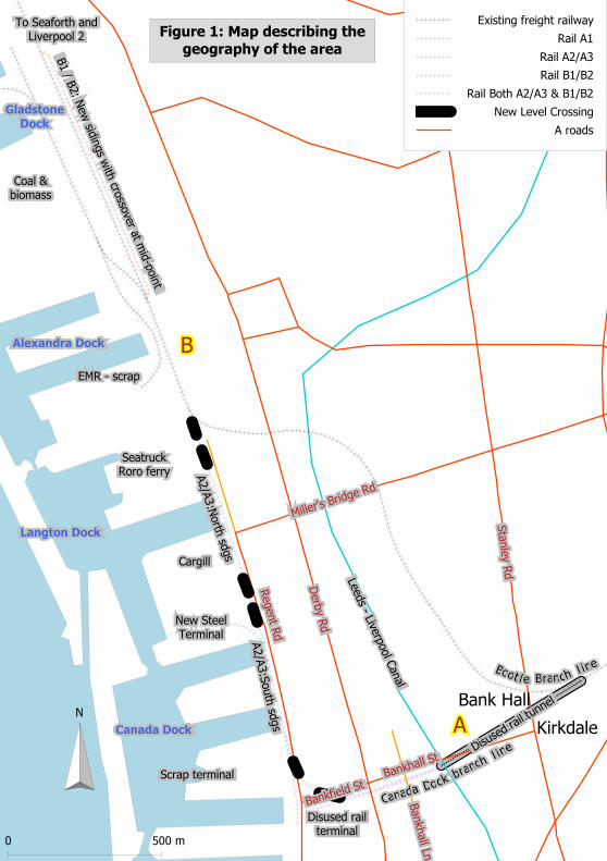
Figure 1 describes the geography of the area. The line leading to the Canada Dock branch line (A)
was built from Tuebrook on the Liverpool – Manchester railway in 1861 and connected the Liverpool
North Docks with the mainline system, supplementing the line that already linked Edge Hill with
Princes Dock (south of the map). 20 years later, an extension of this line was made from Kirkdale to
reach Alexandra Dock (B) in Bootle following a shallower gradient and it is this link that continues to
be used. The Princes Dock branch closed in the early 1970s. The Canada Dock branch line (A) closed
in 1982. All three branches had direct links with a dock railway that ran the length of the North
Docks until around 40 – 50 years ago.
The current facilities in the Alexandra, Gladstone and Seaforth Docks areas cater for coal, biomass,
steel and scrap metal trains. They can also cater for container trains although there are currently no
services.
On weekdays, there are typically 9-12 departures from Liverpool port. These are typically:
5-6 coal trains to Fiddlers Ferry or Ratcliffe power stations
4-5 biomass trains to Ironbridge
a weekly steel train from Sheffield
an occasional scrap metal train.
The present double track Bootle branch line itself is capable of handling 2 trains per hour per
direction, has a W10 loading gauge (capable of handling standard 9’6” high ISO containers on metre
high (standard) wagons) and RA10 axle weight standards (the heaviest available). A Chord (Olive
Mount chord) was replaced some years ago so that trains can now move directly eastwards onto the
mainline towards Earlestown. There is currently a capacity to forward 2 freight trains per hour per
direction along the mainline and there is a reasonable expectation this will be protected after
passenger service frequencies rise once the current electrification and Northern Hub schemes are
completed. Network Rail’s long-term plans (as stated in their Freight Market Study2) are to cater for
approximately 30 train paths per day per direction to and from the port, and they are aware of
Peel’s aspirations for 38 trains per day per direction. When it becomes clearer in the future that
Peel’s aspirations are approaching fruition, Network Rail are likely to adjust their plans to cater for
this demand. See section 7.7 for more detail on capacity. We therefore believe that the rail network
should be able to accommodate the Port’s long term forecasts of being able to generate up to 38
trains per day per direction.
These 38 daily train departures reflect the long term rail freight potential of the port of Liverpool as
a whole. This potential was forecast in a separate report for Peel Ports. There is an implicit
2 www.networkrail.co.uk/improvements/planning-policies-and-plans/long-term-planning-process/market-studies/freight/

Rail Connectivity to the Canada Dock Area. Feasibility and Demand Study Page 5
30/04/15 16:09
Our Ref: 215013r11
assumption that additional rail infrastructure would be required within the port estate to cater for
this level of traffic. These 38 daily train departures include realising the rail potential of the Canada
Dock and southern zone area (south of Alexandra Dock), along with the additional infrastructure
required.
Bankhall St
Bankh
all Ln
Sta
nle
y R
d
Bankfield St
Derb
y Rd
Regent R
d
Miller's Bridge Rd
Kirkdale
Bank Hall
A
B
Gladstone Dock
Canada Dock
Langton Dock
Alexandra Dock
Figure 1: Map describing the
geography of the area
B1 / B
2: N
ew sid
ings w
ith cro
ssover at m
id-p
oin
t
A2/A
3:S
outh
sdgs
A2/A
3:N
orth
sdgs
Disused rail terminal
Canada Dockbranch
l ine
Boot l e Branchl ine
Coal &biomass
To Seaforth andLiverpool 2
Scrap terminal
EMR - scrap
Cargill
SeatruckRoro ferry
New SteelTerminal
Leeds - Liverp
ool C
anal
Disuse
d rail
tunnel
Existing freight railway
Rail A1
Rail A2/A3
Rail B1/B2
Rail Both A2/A3 & B1/B2
New Level Crossing
A roads
N
0 500 m

Rail Connectivity to the Canada Dock Area. Feasibility and Demand Study Page 7
30/04/15 16:09
Our Ref: 215013r11
The Port’s expectation is that this cargo will be made up of biomass, coal and container trains plus a
handful of scrap, steel and automotive trains. Two of the key drivers of this growth are due to two
major investments.
These are:
The Liverpool2 (L2) container terminal, which will be able to accommodate the highest
capacity container vessels in the world (not necessarily at full draft) and raise port volumes
to around 1.3m containers per annum. Because the Port’s ‘reach’ is expected to be national
and not just regional, some 15% of throughput can be expected to be by rail (around
200,000 units per annum) which corresponds to some 15 trains per day per direction.
A large biomass terminal whose throughput will be entirely by rail to power stations
(approximately 12 departing trains per day, matched by empty return trains).
In addition we expect:
residual coal traffic, unlikely to be run-down until around 2024, but (say) 3 departing trains
per day in the long term, (matched by empty return trains).
Steel trains (1 per day departing) via a new steel terminal in Canada Dock, replacing one
located at Gladstone Dock.
Scrap trains carrying 15 – 20% of the Port’s anticipated throughput of 2.5 – 3m tonnes per
annum (2 – 3 trains per day arriving (with the empty return trains departing)).
All these trains will pass as far east as Earlestown. Beyond Earlestown, some will go north and some
south along the West Coast Main Line and some will continue eastwards into Yorkshire.
Most of this potential rail traffic passes through Alexandra Dock and docks further north, and this
will remain the case. However the steel terminal is relocating to the Canada Dock area, with
potential for 1 train departing per day. Large volumes of scrap metal traffic are processed in the
Canada Dock area too (700,000 tonnes in 20143). If we assume that in future around half the scrap
will pass through docks south of Alexandra Dock then that reflects up to 2 scrap trains per day per
direction.
In addition, long term redevelopment of the land between Regent Road and Derby Road as a port
linked distribution park can be expected to eventually accommodate around 150,000m2 of buildings
(say 200,000 pallet capacity). If devoted entirely to maritime traffic that would generate around
100,000 container arrivals per annum and, if sharing the same 15% rail share as for the container
terminal, this traffic could generate another 2 train loads per day per direction of containers.
3 Source: Peel

Rail Connectivity to the Canada Dock Area. Feasibility and Demand Study Page 8
30/04/15 16:09
Our Ref: 215013r11
This distribution park traffic could either be loaded locally onto trains at a small intermodal terminal
in the Canada Dock area, or could be moved by rubber-tyred vehicles to the intermodal terminal at
Seaforth.
For the purposes of designing rail layouts, we have assumed that any rail traffic generated by a
distribution park between Regent Road and Derby Road would travel by rubber-tyred vehicle to the
terminal at Seaforth to be loaded to a train because, overall, we expect this to be the cheaper and
least disruptive option. Our rail layouts for the Canada Dock area therefore do not include an
intermodal terminal. However if a small local intermodal terminal was required for a particular
warehouse occupier, the designs for the main options could be added to in order to incorporate
such a terminal.
There may also be automotive trains in the future if the Port’s target to attract car traffic succeeds,
although we have not included these in the Canada Dock rail freight potential.
Taken together, we therefore estimate that the section of port south of Alexandra Docks has the
potential to generate demand for around 3 trains per day per direction. Two or three local terminals
would be required: one for scrap, one for steel (tracks running into a shed) and potentially one small
intermodal terminal.

Rail Connectivity to the Canada Dock Area. Feasibility and Demand Study Page 9
30/04/15 16:09
Our Ref: 215013r11
3. THE CANADA DOCKS BRANCH ITSELF
In the event of it being reopened, the junction with the ‘Bootle’ branch at Kirkdale (Atlantic Dock
junction) would need to be re-created and the track re-laid along a tunnel of around 400 metres that
appears to drop around 8 metres (approximate gradient 1:60) before passing under the Leeds –
Liverpool canal and emerging through a portal at the level of Regent Road that is currently beneath
around 5m depth of fill, running to the south of Bankhall Street. That fill is continuous between the
Canal and the site of the old rail freight terminal east of Regent Road and entirely encloses the
bridge arches that carried both Bankhall Lane and Derby Road over the railway. Whether these
bridges would retain their integrity if the fill was removed is unknown, as is the state of the tunnel.
The length of level railway formation between the canal and Regent Road is limited to around 400m.
Once length is allowed for switches to create a number of reception loops, no more than 300 metres
of train length could be accommodated. Trains of this short length are costly to operate per tonne
of cargo moved and are generally not viable. As a result we have not given any further consideration
to a rail freight terminus east of Regent Road. This discounted option is referred to as option A1 in
Merseytravel’s Specification.
However it would be possible to receive trains of a competitive length if the rebuilt route crossed
Regent Road and trains were brought to a halt parallel to (alongside) Regent Road. Given that cargo
generating sites will be generally north of this crossing, the curve also would face northwards. To be
able to operate long trains under modern conditions, a curve of 200 metres radius would be
expected, requiring as a result a substantial area of land. In the event of electrification of the wider
network this would imply that such overhead electrification would need to extend across Regent
Road.
The current connection to the Docks at Alexandra Dock involves the railway crossing Regent Road
immediately beyond the point of transfer between Network Rail and Peel Ports. There is no longer a
level crossing; the railway simply severs the roadway, which already limits free circulation even
though the roadway is no longer adopted highway4.
While a rail crossing of Regent Road in the Canada Dock area could be organised as a level crossing
across an adopted road, the required curvature is such that Bankfield Street would also have to be
crossed, making a highly complex arrangement. Network Rail believes the Office of Rail and Road
(ORR) may take issue with the introduction of new level crossings on the public highway, whether or
not the rail infrastructure was privately (Peel) or publicly (Network Rail) owned. It is therefore
difficult to envisage such an arrangement without closing Regent Road and Bankfield Street to public
4 The intention is to re-instate this level crossing. This would be in conjunction with the planned dualling of
this part of the branch line. The level crossing would serve part of the LIFT Zone (port-centric warehousing). One of the units on the other side of the level crossing is currently being built.

Rail Connectivity to the Canada Dock Area. Feasibility and Demand Study Page 10
30/04/15 16:09
Our Ref: 215013r11
traffic. It is Peel Port’s aspiration under its Master Plan that Regent Road is absorbed within the
Dock Estate to better serve the re-development of the Regent Road – Derby Road corridor as an
employment site for distribution (150,000m2 of distribution sheds would be expected to employ
around 1,500 people). In that event there would be no need for a level crossing because both
Bankfield Street and Regent Road could be closed at this point and road access to the port area
north of Bankfield Street would be via Millers Bridge Road.
For trains entering the Port through a re-instated Canada Dock branch line, the operational
connection between Network Rail’s network and that of Peel Ports could be at the Regent Road end
of the route because the length of the branch (approximately 700m from the connection to the
Bootle branch at Kirkdale and the level crossing over Bankfield Street) exceeds the length of the
trains likely to be serving the Canada Dock area. The rear of an arriving train brought to a halt at a
level crossing across Bankfield Street would be clear of the junction with the Bootle branch.
However for departing trains, as we shall discuss in section 5, a train held on tracks alongside Regent
Road awaiting release onto the Network Rail network will block several road accesses into the Docks
which would be unacceptable. It would be essential that the Port is able to forward a complete train
through the Regent Road and Bankfield Street level crossings onto the branch line towards Kirkdale
at a time of its choosing. This means the branch between Bankfield Street level crossing and
Kirkdale must be under the Port’s control and the connection agreement between Peel ports and
Network Rail must be adjacent to the junction with the existing Bootle branch near Kirkdale station.
While it would be possible for Regent Road to remain a public road and for there to be level crossing
arrangements that are acceptable for ‘uncontrolled’ public access and for the crossing to be
operated by Peel Ports, such an arrangement would be most unusual. This is particularly the case
because the crossing would have to cater for several different vehicle manoeuvres (Regent Road
North to Regent Road South, Regent Road South to Bankfield Street and Regent Road North to
Bankfield Street and the reverse).

Rail Connectivity to the Canada Dock Area. Feasibility and Demand Study Page 11
30/04/15 16:09
Our Ref: 215013r11
4. INFRASTRUCTURE OPTIONS AVAILABLE
The infrastructure options to provide rail connectivity to the Canada Dock area that we have
considered are:
A1: Re-open the Canada Dock branch with a direct route towards Regent Road, terminating east
of Regent Road. This would require restoring the tunnel and rebuilding (or restoring) 2 road-
over-rail bridges (Bankhall Lane and Derby Road).
A2/A3: As A1 but instead of terminating east of Regent Road, build a 200m radius north-facing curve
crossing Bankfield Street and Regent Road towards Miller’s Bridge Road (with tracks
terminating some 900 – 1000 metres to the north near Miller’s Bridge Road, which is a train
length plus switches allowing train splitting and locomotive return). A short headshunt
south of Canada Dock would allow a new scrap terminal to be served. This option is later
referred to as option A2 or A3 depending on the land ownership of Regent Road.
B1/B2: Instead of reopening Canada Dock Branch, replace the Dock railway alignment from
reception tracks at Alexandra Dock for some 1500 metres southwards to Canada Dock. This
would follow the same alignment as for A2/A3 above along Regent Road plus an additional
400 metres of track between Miller’s Bridge road and the current rail crossing of Regent
Road. This option is later referred to as option B1 or B2 depending on the land ownership of
Regent Road.
C: Do nothing. This option is most simply interpreted as assuming all traffic to/from the
Canada Dock area goes by road. However it would still be possible for traffic suitable for rail
in the Canada Dock area to travel by rail, if it first travelled by road to an existing or adapted
rail terminal in the Alexandra / Gladstone Dock area.
For options A2 and B1, Regent Road is retained as a public road. For A3 and B2, the Regent Road
area becomes part of the port estate, as per Peel’s aspirations in their port Master Plan.
Fuller details of all the options are given in the job specification: Appendix 7 to this report.
Sketches for the A and B options are described in figure 1.We have produced potential track layout
designs reflecting these options. These are shown in Appendix 1.
In order to produce these designs, we have considered (A2/A3) and (B1/B2) in turn from an
operational perspective in order to cater for the likely demand (up to a total of 3 scrap and steel
trains arriving and then departing each day). These potential train movement schedules are
described in section 5.

Rail Connectivity to the Canada Dock Area. Feasibility and Demand Study Page 12
30/04/15 16:09
Our Ref: 215013r11
In options B1/B2, it is assumed that the existing rail route into Alexandra Docks is used. This would
use up capacity in the area. In a future scenario with a significantly larger number of trains, using
this capacity for Canada Dock trains could be to the detriment of other trains. The A2/A3 option has
no such detrimental impact on other rail freight traffic in the Alexandra Dock area.
Therefore, in order to make a fair comparison between A2/A3 and B1/B2, for the B1/B2 option we
need to include some infrastructure enhancement in the Alexandra Dock area that will reflect the
capacity usage of the Canada Dock trains.
We believe that a fair contribution to address that additional demand would be to build an extra
reception track alongside the existing route to Seaforth (to the east of the coal terminal), with a
crossover at the mid-point onto the existing route to Seaforth. This can be seen in the track layout
design (Appendix 1) (“B1/B2: New siding – with crossover at mid-point”). Our calculation is that the
capacity contributed by this option is broadly equivalent to the capacity used (shown in Appendix 3).
However we have also considered a more generous infrastructure contribution to the Alexandra
Dock rail network which contributes more capacity than the Canada Dock trains would use. This
involves:
Double-tracking the route from the Bootle branch into the Alexandra Dock area (as per
Peel’s existing plans)
Continuing this extra track northwards to become a dedicated route to Seaforth which
would never be blocked by the marshalling of the Canada Dock trains.
This more generous infrastructure enhancement is drawn in the layout designs (Appendix 1) and has
been costed as a worst-case infrastructure-cost scenario.
The future daily rail freight potential for the Port of 38 trains arriving (and 38 departing) implies that
the present double track Bootle branch needs in any case to be extended into the Alexandra Dock
area so that trains can depart the Docks independently from trains arriving. There would be no need
to create an active level crossing at this point but to instead use the width of Regent Road at that
point for extra reception tracks. In the long run, these could be electrified as no cargo handling will
take place near them and they could even be fenced (see long term plans for freight electrification
to Liverpool2 in ‘Northern Sparks’, Rail North, March 2015).
However, this arrangement would still require an internal level crossing if road vehicles are to pass
southwards along the dock road that is not currently in position. This could be provided by retaining
an internal road connection west of the steam pipeline and creating an inland level crossing at a
skew across a new single railway line immediately south of the present crossing of Regent Road by
passing under the steam pipeline within the dock estate. This will mean that the level crossing is

Rail Connectivity to the Canada Dock Area. Feasibility and Demand Study Page 13
30/04/15 16:09
Our Ref: 215013r11
only used by relatively infrequent short trains that could be conducted entirely by a Port operated
shunting locomotive. This would be far easier to manage than one where full length trains are
received from the Network Rail network over ‘public’ roads. This solution would not itself require
the transfer of the full width (see below) of any current public road.
Whichever option is selected, however, because there is existing plant adjacent to the current Port
boundary (covering some of the width once occupied by the dock railway), the most sensible
approach may be to reduce the current width of Regent Road so that a single track railway
supplemented by loops can be laid, along what is presently public highway, alongside the current
Port boundary. This would not affect the functionality of the road but would require fencing if public
access to the highway is to be retained.

Rail Connectivity to the Canada Dock Area. Feasibility and Demand Study Page 14
30/04/15 16:09
Our Ref: 215013r11
5. POTENTIAL TRAIN MOVEMENT SCHEDULES
Modern freight trains within the Docks are limited to a trailing weight of around 2,000 tonnes and to
a length of around 600 metres. Weight constrained trains (scrap, coal, steel etc.) will be limited to a
length of around 500 metres. If bulk trains much longer than 500 metres were used, they would be
very heavy and would need to be hauled by more powerful (non-typical) locomotives. These
powerful locos would be required to ensure that the train could accelerate fast enough to minimise
the extent to which they obstruct other faster trains on the wider network.
Trains will enter and leave the Network Rail network complete but can be subdivided once within
reception sidings. With the exception of the track that serves the coal terminal (and the biomass
terminal that will be adjacent) none of the terminals within the Docks can be expected to handle
unbroken trains, either because the individual sites within the Docks are too small or because
holding long trains would block roadways essential to the circulation of Docks traffic.
Reception tracks have to be more or less flat because wagons will not be attached to manned
locomotives at all times.
We have assumed trains of up to 510 metres trailing length + 25m for the locomotive, so that these
can be split into 3 x 170 metre wagon lengths (front, middle and rear train-thirds). Such 170 metre
long portions of train are typical for steel and scrap terminals. They are not too long so as to require
too large a terminal area and they are not too short so that they require excessive shunting
movements to process a full train.
In each infrastructure option (A2/A3) and (B1/B2), we propose a train movement approach whereby
port terminals are only briefly obstructed by trains and at no time are blocked by a train for more
than a few minutes where possible. Apart from (A2/A3) arrival and departure, to minimise the time
the various road access points are closed, all movements across the road access points to port areas
are either a sole loco or a loco hauling (not propelling) a short section (one third) of train.
For scrap trains, we have assumed that the steel terminal track is available to store one train-third.
Similarly for steel trains, we have assumed that the scrap terminal loop is available to store one
train-third and for running the loco around. For both infrastructure options (A2/A3 and B1/B2), if it
was preferable for the steel and scrap terminals to be independent of each other, this could be
achieved with (for example) an additional track alongside the scrap terminal loop.
Train movement processes below should be read in conjunction with the track layout designs
(Appendix 1). The locations are marked on these designs.

Rail Connectivity to the Canada Dock Area. Feasibility and Demand Study Page 15
30/04/15 16:09
Our Ref: 215013r11
5.1 Option (A2/A3) operations: Canada Dock Branch re-instatement.
Movements associated with arrival, processing in steel terminal, and then departure.
1. Close Regent Road and Bankfield Street level crossings to road traffic
2. Close Cargill and new steel terminal road access
3. Cross Bankfield Street and Regent Road over level crossings
4. Just clear Regent Road with back of train and stop
5. Open Regent Road and Bankfield Street level crossings to road traffic
6. The front end of the train blocks Cargill and new steel terminal road access
7. Uncouple the back 2/3 of the train (340m of wagons) (which lies between Regent Road level
crossing and the new steel terminal’s road access)
8. Haul front train-third forward into A2/A3 Northern sidings so no road access points are
blocked
9. Open Cargill and new steel terminal road access
10. Run loco round and attach to northern end of rear 2 train-thirds
11. Propel rear 2 train-thirds so that the rear train third is in the scrap terminal loop
12. Split the middle and rear train-thirds by uncoupling
13. Haul the middle train-third (170m of wagons) into A2/A3 Southern sidings. Decouple
14. Attach to southern end of rear train-third and propel into the steel terminal
15. Once processed, haul this train-third into the scrap terminal loop. Decouple
16. Attach to middle train-third, haul and propel into steel terminal
17. Once processed, return the middle train-third to the A2/A3 Southern sidings. Decouple
18. Attach to front train-third, haul and propel into steel terminal. Decouple
19. Haul rear train-third to A2/A3 Northern sidings. Decouple and return to steel terminal
20. Once processed in steel terminal, haul this train-third into the scrap terminal loop
21. Propel new rear train-third and attach to middle train-third
22. Close Cargill and new steel terminal road access
23. Propel middle and rear train-thirds together northwards to attach to the front train-third in
A2/A3 Northern sidings to assemble the full train
24. Conduct brake test
25. Close Regent Road and Bankfield Street level crossings to road traffic
26. Depart – crossing Regent Road and Bankfield Street up to NR boundary at eastern end of
Canada Dock tunnel
27. Open Cargill and new steel terminal road access
28. Open Regent Road and Bankfield Street level crossings to road traffic
These movements are described in more detail in Appendix 2 with distances and timings for each
movement.

Rail Connectivity to the Canada Dock Area. Feasibility and Demand Study Page 16
30/04/15 16:09
Our Ref: 215013r11
We estimate the time that a train would be on-site (from the closing of Bankfield Street level
crossing to road traffic when the train arrives to the re-opening of the level crossing after the train
leaves) would be approximately 5 hours.
Several of these movements involve the blocking of roads while the trains, train-thirds or sole
locomotives pass. Appendix 4 notes each such blocking manoeuvre along with the time that the
road is blocked and shows the calculations for the overall HGV delay per train.
The total delay caused to HGVs is dependent on both the number of railway movements, and the
level of HGV traffic across each level crossing and road access point.
We have made tentative estimates of future HGV traffic volumes at each level crossing and road
access point. For example for the future, we estimate 800 HGVs per day through the Seatruck gate,
including some sole HGV tractors without trailers. In total, we calculate the overall HGV delay
caused by one train arriving and departing to be 2 hours 40 minutes of HGV time per day. Most of
this is due to the full train when fully assembled awaiting departure and conducting a brake test.
This blocks both the Cargill and the new steel terminal’s road access points, during which time a
queue will build up.
A stationary HGV with driver on-board costs around £35 per hour (principally depreciation and
driver’s wages). Therefore a 2 hour 40 minute HGV delay equates to approximately £93 in HGV cost
per day, along with a decrease in reliability and a need for the space for these HGVs to queue. At
public sector discount rates typically used for rail projects this would equate to a capitalised value of
£0.7m.
Arrival, processing in SCRAP terminal, and then departure.
Equivalent movements to those described above for the steel terminal can be performed to process
scrap trains. The steel terminal is used to store a train-third after processing in the scrap terminal.
5.2 Option (B1/B2) operations: Extending from existing rail terminal (Alexandra Docks
area) south to Canada Dock.
The movements described below relate to the less generous infrastructure contribution to the
Alexandra Docks area – intended to match capacity provided with capacity used (see Appendix 3) –
i.e. they do not include the double-tracking from the Bootle branch or the dedicated route to
Seaforth.
Rail Connectivity to the Canada Dock Area. Feasibility and Demand Study Page 17
30/04/15 16:09
Our Ref: 215013r11
Movements associated with arrival, processing in steel terminal, and then departure.
1. Arrive into northern end of new reception track (to the east of the coal terminal and
alongside the existing route to Seaforth)
2. Train blocks one potential road access point to a factory until the rear third is moved,
and when the train is reassembled to depart. There is an alternative road access point
to this factory, so we have not included HGV delays for this point
3. Split the wagons into 3 train-thirds by uncoupling
4. Run loco around and attach to southern end of rear train-third
5. Haul this rear train-third (170m of wagons) south until the back end clears the route to
the steel terminal
6. Propel the rear train-third into the steel terminal
7. Once rear train-third is processed, haul to the scrap terminal loop and run around
8. Haul the rear train-third north and leave it on the route to Seaforth – adjacent to the
southern end of the new reception track. Decouple
9. Return to the new reception track via the crossover at the mid-point and attach to
middle train-third
10. Haul and propel into steel terminal
11. Once middle train-third is processed, haul to the scrap terminal loop and run around
12. Haul the middle train-third north and enter the new reception track
13. Crossover onto the original adjacent route to Seaforth and pull alongside front train-
third
14. Propel middle train-third to attach to rear train-third. Decouple
15. Return to the new reception track via the crossover at the mid-point and attach to front
train-third
16. Haul and propel into steel terminal
17. Once front train-third is processed, haul to the scrap terminal loop and run around
18. Haul this front train-third north and enter the new reception track
19. Crossover onto the original adjacent route to Seaforth
20. Propel front train-third to attach to middle and rear train-thirds to re-form the full train
21. Run round and attach loco to southern end of train
22. Conduct brake test and depart
Again, these movements are described in more detail in Appendix 2 with distances and timings for
each movement.
We estimate the time that a train would be on-site would be approximately 5 hours 30 minutes.
Again, several of these movements involve the blocking of roads while the trains, train-thirds or sole
locomotives pass. Appendix 4 notes each such blocking manoeuvre along with the time the road is
blocked for.

Rail Connectivity to the Canada Dock Area. Feasibility and Demand Study Page 18
30/04/15 16:09
Our Ref: 215013r11
In total, we calculate the overall HGV delay caused by one train arriving and departing with the
B1/B2 infrastructure to be just 12 minutes, equating to £7 in HGV cost (a capitalised value of
£50,000). This is far less disruptive in terms of HGV delay than option A2/A3. This is largely because
the train does not have to be re-formed and readied for departure while blocking road accesses.
Arrival, processing in SCRAP terminal, and then departure.
A similar operation can be performed for scrap trains.
If a quicker turnaround is required, while the first train-third is being processed in the steel terminal,
the loco can haul the next train-third from the reception sidings to the scrap terminal loop, so that
when the steel terminal has finished with the first train-third, the second train-third can be quickly
propelled into the steel terminal.
Extra capacity usage at the existing Alexandra Dock terminal area is compensated for by allowing
other trains to use the extra reception track when Canada Dock trains are not there. – e.g. container
trains. This is discussed in more detail in Appendix 3.
There appears to be space to create other sidings nearer to Seaforth for other additional container
trains, so this extra siding is not using up space that would necessarily be required to cater for the
forecast increase in container trains serving Seaforth.
We conclude that either approach (A2/A3 or B1/B2) is operationally viable.
For both options (A2/A3 or B1/B2), higher volumes of trains could be catered for by building
additional sidings.

Rail Connectivity to the Canada Dock Area. Feasibility and Demand Study Page 19
30/04/15 16:09
Our Ref: 215013r11
6. LONGER TERM ASSOCIATED DEVELOPMENT
The re-development of the area north of Bankfield Street between Derby Road and Regent Road by
the construction of around 150,000m2 of warehousing would generate some 400,000 heavy vehicle
movements per annum, as follows:
area available: 150,000m2
equivalent pallet positions: 200,000
vehicles/40’ containers: 8,000
turnover: 4 weeks
loaded arrivals per annum: 100,000
empty departures per annum: 100,000
empty arrivals per annum: 100,000
loaded departures per annum: 100,000
_______
Total movements per annum 400,000
Movements per day (5 day week): 1,600
Movements per hour (2 shift day): 100
This length of Regent Road would become extremely busy, given there is likely to also be some 2m
tonnes of steel, scrap and edible oil traffic plus freight ferry traffic in and out of the Seatruck
terminal. Altogether we estimate that up to 3,000 HGV movements per day could be generated in
addition to rail freight train movements and in many hours of the day there could be 200 HGV
movements, all of which would be making turning movements in and out of terminals or
warehouses.

Rail Connectivity to the Canada Dock Area. Feasibility and Demand Study Page 20
30/04/15 16:09
Our Ref: 215013r11
7. CONNECTIONS TO NETWORK RAIL AND MODE OF OPERATION
As volumes of trains rise the need for enhanced safety systems/procedures within the port will
increase. If the only extra traffic were the handful of Canada Dock trains we estimate, there is an
argument to retain the form of operation that exists today. However, when one takes into account
the dock operation as a whole and the potential for 38 trains per day per direction there is a
stronger argument for an enhanced level of control and improvement of reception and departure
arrangements.
7.1 Canada Dock
The connection to the Bootle Branch from Canada Dock no longer exists. Civil engineering required
to reinstate the junction is considered significant, with cost estimates given in Appendix 5. No
assessment of the signalling and control arrangements has been made at this time. However the
proximity and complexity of the level crossing arrangements that would be required on the public
highways suggest this option would present significant challenges in developing a form of protection
to both road and rail users that would be acceptable. Given the risk of trespass and other safety
issues, Network Rail and the ORR would consider the level crossings at Bankfield Street and Regent
Road unacceptable if the roads remained public.
The HGV movements across the road access points to Seatruck, Cargill and the new Steel terminal
would generally be gate controlled. For HGVs arriving along the road the simultaneous movement
of a train section would be self-evident. The gates could all be equipped with sensor equipment so
that exiting HGVs could be briefly held in the event of a passing train section.
Such an environment with train movements, many HGVs and HGV turning movements would not be
well suited to also catering for a large numbers of pedestrians and cyclists.
7.2 Alexandra Dock
The existing layout provides for the double track Bootle Branch to run through the Alexandra Dock
Tunnel where it becomes a single line. The single to double track connection is shown in the
Network Rail record as trailable sprung points configured for the departure direction and trailed
when entering the port. The double track section and the beginning of the single track section are
under the control of Edge Hill Signal Box. The Bootle Branch is operated using track circuit block
principles with two aspect signalling.
The single line within the dock is under the control of the Person In Charge (PIC). Operation within
the dock appears to be through manual instruction and hand point operation. A level crossing at
Regents Road (AOCL Type – Automatic Open Crossing Locally Monitored) is shown on the Network
Rail Records but is out of use with the road blocked off adjacent to the railway line. Track circuit
controls are provided locally for the operation of the level crossing.

Rail Connectivity to the Canada Dock Area. Feasibility and Demand Study Page 21
30/04/15 16:09
Our Ref: 215013r11
Trains arriving at the Dock are signalled up to a Stop Await Instructions board by the Network Rail
Signaller. Track circuit controls and indications are provided to Edge Hill Signal Box to prove the
absence of trains on the approach to the stop board. Movement authority into the dock is granted
verbally by the Person in Charge.
Trains departing the dock require the Person in Charge to obtain a Line Clear release from the
Network Rail Signaller before verbal movement authority can be given allowing the train to advance
to ML62 signal at Bootle Junction.
The existing access arrangements are only suitable for low volumes of traffic and slow speed
movements.
7.3 Creation of Reception and Departure Roads
The creation of Reception and Departure Roads under the control of the Person in Charge would
require re-designation of the lines, relocation of the control boundary and revision to the local
operating procedures through negotiation and agreement with Network Rail. Additional controls
and indications would be required to inform the Person in Charge that the route up to ML62 Signal
and its overlap is clear.
Trains arriving at the dock could do so under the same method as exists today though agreement on
control boundaries and adaptation of the local instructions would be required.
Maintenance boundaries associated with the infrastructure assets do not need to align with the
control boundaries but would need to be agreed.
7.4 Mode of operation within the dock
Low volumes of train movements at slow speeds are commonly managed through manual operation
and verbal movement authority. As the volume of train movements within the dock increases,
exacerbated by the need to split and join trains, manual operation becomes increasingly time
consuming and unsafe. Careful consideration would need to be given to determining the
appropriate level of automation of point operation and control of movement authority to ensure
train movements are made efficiently but safely.
7.5 Segregation of road traffic from train movements
As the volume of trains increases the risk of collision with road vehicles will increase. It is considered
likely that the adopted roads (Regent Road and Bankfield Street) would need to be taken back into
port control and conflict management employed in a form of level crossing control to protect
movements on road / rail crossing points within the port implemented. The proximity of dock access
points and the length of trains being manoeuvred make it likely that crossings may be required to
close in sequence or simultaneously. This would form a constraint on how train movements are

Rail Connectivity to the Canada Dock Area. Feasibility and Demand Study Page 22
30/04/15 16:09
Our Ref: 215013r11
authorised within the dock area and the locations that they are authorised to move between. If this
is not under some form of signal control system then local operating procedures would need to be
developed, informed by risk assessment where appropriate, to ensure safe movements of train and
lorry are able to be made whilst maintaining efficiency and performance within the dock. It may be
necessary to define “block sections” through which trains are authorised to move and within which
conflicts with the train movement are prevented.
7.6 On-site shunter locomotive method of operation in the Canada Dock area
Once the intensity of train movements increases beyond a threshold, instead of using expensive
main-line locomotives to shunt trains and train-sections within the Canada Dock area, a more
efficient option may be for within-port movements to be hauled by an on-site shunter locomotive.
This would free up the main-line locomotives to depart soon after arriving with a different set of
wagons. This could be an added service that Peel Ports supply to the rail freight sector for an
appropriate fee. Peel Ports could either purchase a shunter themselves or hire one through a spot
hire company.. Alongside implementation of a “Rail Traffic Management System” within the port’s
rail network, this would enable equitable treatment of freight train operators using the port
(currently two freight operators DB Schenker and GB Railfreight) rather than the current situation
whereby DB Schenker informally manage operations for all operators.
This is only an efficient method of working if there is sufficient rail traffic at the port for there to be a
fully formed train waiting to depart soon after a main-line locomotive arrives, such that freight train
operators can achieve better and more efficient usage of their main-line locomotives.
Using an on-site shunter opens up the possibility of electrification of the Bootle branch - into the
Alexandra reception sidings, from which point the on-site shunter(s) can haul the trains and train
sections to their final destinations within the port. There are plans for electric locomotives with “last
mile” diesel capability (i.e. incorporating a low power diesel engine) such as the Class 88s ordered by
Direct Rail Services. These hybrids open up the possibility of running “principally-electric” trains to
Alexandra Dock reception sidings even without electrifying the Bootle branch line, by relying on the
low-power diesel engine between Alexandra Dock and the recently-electrified main line (Chat Moss
route between Liverpool and Manchester). However journey times along the non-electrified Bootle
branch would be significantly longer due to relying on the low power diesel engine. In principle, in
the absence of a dedicated on-site shunter, it would be possible to use these hybrids as on-port
shunters, as main-line diesel locomotives are now. However away from electrified lines, they are
low-powered and expensive assets: not ideal for conducting such shunting operations.
The volumes of traffic in the Canada Dock area will be sufficiently low to be serviced by one on-site
shunter, which may also spend some time in other parts of the port, when not required in the
Canada Dock area.

Rail Connectivity to the Canada Dock Area. Feasibility and Demand Study Page 23
30/04/15 16:09
Our Ref: 215013r11
In the Canada Dock area, this on-site shunter could operate an arrangement similar to the tram
management system on Manchester Metrolink. Each tram operates independently – controlling
level crossings to give it priority as it passes.
7.7 Capacity
The potential train movement schedules in section 5 describe a movement schedule that takes
approximately 5 hours (option A2/A3) or 5 hours 30 minutes (option B1/B2) between arrival and
departure for each train. This allows sufficient time for 3 trains to arrive and then depart per day.
For option B1/B2 the extra infrastructure required to be built in the Alexandra Dock area is discussed
in Appendix 3. If more than 3 trains (to arrive and then depart per day) were required in the Canada
Dock area, additional infrastructure (for example additional loops or a small intermodal terminal)
could be built.
There are also capacity constraints on Network Rail’s wider network. On the Bootle branch line,
there is capacity for 2 trains to run per hour in each direction5. This is confirmed in practice because
trains do sometimes arrive within 30 minutes of each other (and similarly sometimes depart within
30 minutes of each other)6 – both in terms of timetabled timings and actual timings along the Bootle
branch route. This is despite the current low volume of trains. 2 trains per hour per direction is just
sufficient capacity to cater for 38 departures per day, if the trains could be organised to arrive at a
consistent rate throughout the day.
To provide more capacity and therefore flexibility (to better integrate with timetabling requirements
on the wider network) and robustness, Network Rail plan to improve the Bootle branch line-speed7,
and capacity (by adding intermediate signals in each direction8 and dualling the route into the
Alexandra Dock reception sidings9), which is entirely independent of the reopening of the Canada
Dock Branch.
Whether the trains leave the Bootle Branch at the existing Regent Road level crossing to Alexandra
Dock (B1/B2), or at a re-instated Atlantic Dock junction directly to the Canada Dock area (A2/A3)
makes little difference to the branch line capacity.
5 Page 7 of Strategic Freight Network Steering Group: Trans-Pennine and Northern Ports Freight Capacity.
Network Rail, Dec 2014 6 Source: MDST analysis of actual timings of trains in and out of Liverpool port
7 Page 8 of Strategic Freight Network Steering Group: Trans-Pennine and Northern Ports Freight Capacity.
Network Rail, Dec 2014 8 Page 7 of Strategic Freight Network Steering Group: Trans-Pennine and Northern Ports Freight Capacity.
Network Rail, Dec 2014 9 Page 6 of Strategic Freight Network Steering Group: Trans-Pennine and Northern Ports Freight Capacity.
Network Rail, Dec 2014

Rail Connectivity to the Canada Dock Area. Feasibility and Demand Study Page 24
30/04/15 16:09
Our Ref: 215013r11
Beyond the Bootle branch, trains reach the route towards Earlestown and Manchester (the Chat
Moss route). Network Rail’s “Northern Hub” scheme involves significantly more passenger trains
along this route. There is therefore a danger that capacity may become limited for freight trains to
and from Liverpool port. However we have analysed a Northern Hub Indicative Train Service
Specification (ITSS)10 from Network Rail along the Chat Moss route. This included 2 paths per hour
per direction between Liverpool port and Earlestown. Figure 2 describes this proposed train
schedule, with the freight paths highlighted.
More recently, in their North of England Programmes (Northern Hub and North West Electrification)
Network Rail have only considered 1 freight train path per hour per direction between the port and
Earlestown (for the West Coast Main Line), but the Northern Ports and Transpennine Freight Study
will also be testing the robustness of options required for 2 freight train paths per hour per direction
against the full North of England service specification (known as Configuration State 7). It is easier to
include freight paths if these paths are part of the timetabling exercise from the beginning, rather
than trying to fit additional freight trains into a timetable optimised around passenger services.
Network Rail’s long-term plans (as stated in their Freight Market Study11 for 2043) are to cater for
approximately 30 train paths per day per direction to and from the port, and they are aware of
Peel’s aspirations for 38 trains per day per direction and have agreed to consider it as a scenario as
part of the Liverpool City Region Strategic Rail Study. When it becomes clearer in future that Peel’s
aspirations are approaching fruition, Network Rail are likely to adjust their plans to cater for this
demand. We therefore believe that the rail network should be able to accommodate the Port’s long
term forecasts of being able to generate up to 38 trains per day per direction (i.e. 2 per hour x 19
hours).
The Liverpool City Region’s Long Term Rail Strategy (Summer 2014) represents a long term vision for
the region including the possibility of re-opening the Bootle branch line to passenger trains serving
new stations. If this were to happen, there may be a need for further infrastructure enhancement to
improve capacity to cater for this mixed use.
10
ITSS 06/12/12 (Modified) (Version 5) 11/03/13. A later version (CS7 ITSS. PROPOSED TO IPG 07 NOVEMBER 2013. (SUB GROUP VERSION 28.10.13) ) also included these 2 paths per hour per direction between Liverpool port and Earlestown 11
www.networkrail.co.uk/improvements/planning-policies-and-plans/long-term-planning-process/market-studies/freight/

Rail Connectivity to the Canada Dock Area. Feasibility and Demand Study Page 25
30/04/15 16:09
Our Ref: 215013r11
Figure 2: Northern Hub proposed train schedule for one hour with Liverpool port freight paths shown in red

Rail Connectivity to the Canada Dock Area. Feasibility and Demand Study Page 26
30/04/15 16:09
Our Ref: 215013r11
8. CAPITAL CONSTRUCTION COSTS
Gleeds has provided estimates of the capital construction costs for options A3 and B2. The
breakdown of these costs is shown in detail in Appendix 5. The results are:
£23m for A3: Reinstatement of the Canada Dock branch with curve and route alongside
Regent Road.
£11m for B2: Access from existing Alexandra Dock area, providing one new reception track
in Alexandra dock (sufficient capacity to compensate for the extra Alexandra dock area rail
capacity used)
£18m for B2b: As B2 but with generous infrastructure provision: double-tracking the route
from the Bootle branch and providing a dedicated new track to Seaforth (generous capacity
to compensate for the extra Alexandra dock area rail capacity used)
These costs do not include land values – see section 9.
The estimate for A3 is tentative because the state of the tunnel under Kirkdale and the road bridges
(Bankhall Lane and Derby Road) is not clear. This estimate assumes the road bridges have to be re-
built. A best-case scenario whereby the existing bridges were in a good condition and did not need
rebuilding may reduce costs by up to £3m. However an optimistic view of the state of the tunnel has
been taken with little structural work required to the tunnel. As the state of the tunnel is unknown,
the costs could be much higher – up to say £7m more expensive in a worst case scenario.
These costs do not include the cost of the terminals themselves. These terminal costs are common
to options A2, A3, B1 and B2. For option C (no direct rail access to the Canada Dock area), there
would also be costs associated with either adapting an existing terminal (e.g. the EMR terminal), or
creating a new terminal in the Alexandra Dock area if any rail potential demand in the Canada Dock
area is to be satisfied.
On-going maintenance costs for the rail-connecting options are not included. Having the equivalent
traffic going by road to/from the Canada Dock area also involves maintenance costs due to wear and
tear on the roads.

Rail Connectivity to the Canada Dock Area. Feasibility and Demand Study Page 27
30/04/15 16:09
Our Ref: 215013r11
9. LAND ASSEMBLY
In relation to delivery of the options considered within this report JLL has undertaken an analysis of
the relevant land ownerships that would be affected by each option and has considered the
indicative land assembly costs associated with each of these options. Plans showing the relevant
land required to facilitate options A1 and A2/A3 are included at Appendix 6.
In relation to the land that would be required to deliver options within the Port of Liverpool estate
and the public highway, we have consulted with Peel Ports and the highway authorities of both
Liverpool City Council and Sefton Council, to establish respective land ownerships. For all other land
ownerships required to deliver the options, ‘on line’ Land Registry searches have been undertaken
to establish the ownership.
The approach adopted in relation to the calculation of land assembly costs specifically excludes any
land assembly costs associated with land within the ownership of Peel Ports or highway land within
the control of Liverpool City Council or Sefton Council. The justifications being:
that the economic benefit of the introduction of this heavy rail link supports the growth of
Superport and the Port of Liverpool, which are key economic drivers for the City Region;
and the environmental benefits (including reduced road congestion) of encouraging a switch
from road to rail.
Regent Road and Bankfield Street are adopted highways, and are unregistered, and as such we are
unable to comment upon whether there are no encumbrances, restrictions, easements or other
matters of an onerous nature, which would have a material effect on the deliverability of the options
reliant upon use of the public highway. We recommend that verification be obtained from lawyers
representing Liverpool City Council and Sefton Council.
Set out in the table below is the indicative third party land assembly costs associated with the
delivery of Options A1 and A2/A3. As the balance of the land required to deliver the options is in
either Peel Ports or local authority ownership (Options A2/A3, B1 and B2) no land assembly cost has
been included for these land interests for the reasons set above. This Peel Ports or local authority
land in question relates to the potential rail route on the western side of Regent Road.
In arriving at our assessment of indicative land assembly costs we have had regard to recent
comparable land transactions in the Merseyside area and have adjusted these to reflect the
proximity of the land in question to the Port of Liverpool. Where sites contain operational buildings
we have included an additional allowance within the overall land assembly costs to take account of
these.

Rail Connectivity to the Canada Dock Area. Feasibility and Demand Study Page 28
30/04/15 16:09
Our Ref: 215013r11
Indicative third party land assembly costs associated with the delivery of Options A1 and A2/A3
Option
Number of
registered legal
interests
Approximate total
site area
Ha (Acres)
Approximate site area
required for rail
infrastructure
Indicative land
assembly cost*
A1 5 3.80 (9.44) 1.31 (3.24) £2,500,000
A2/A3 9 6.76 (16.73) 1.04 (2.57) £8,560,000
*Assumes total site area acquired taking into account both land and buildings where applicable.
It is worth highlighting that the indicative land assembly costs do not take into account the costs of
disturbance or business relocation / extinguishment costs that may apply in relation to the delivery
of each option as this goes beyond the scope of this study. Clearly, the impact of the introduction of
a heavy rail line on affected existing business operations could result in substantial disturbance /
relocation/ extinguishment payments being justified. Incorporating these would increase the land
assembly costs.
However to balance this, the total land area associated with each affected site would not necessarily
be required to build the rail routes. There also may be some flexibility over the design of the curve
for options A2/A3. For example a tighter curve could potentially be built that would reduce the
impact on the land north of Bankfield Street.

Rail Connectivity to the Canada Dock Area. Feasibility and Demand Study Page 29
30/04/15 16:09
Our Ref: 215013r11
10. OPERATIONAL COSTS
The operational rail costs associated with options A3 and B2 are similar.
Option C (do nothing) has zero capital costs if all the traffic travels by road. However for traffic that
is suitable for rail, travelling by road instead incurs additional operational cost depending upon the
length of haul. For such traffic that is suitable for rail, there is a halfway house option: to travel by
road to an existing or adapted rail terminal in the Alexandra / Gladstone Dock area, and we have
estimated that cost.
The EMR scrap metal terminal may be an appropriate choice of existing terminal that could be used
for such operations. Terminal operators that have available capacity are required by law to allow
third parties to use their terminals on request. The EMR terminal has 3 sidings and low traffic
volumes (less than one train arriving and then departing per day). Assuming Peel were able to make
changes to EMR’s lease, they would be able to require that the terminal becomes an open access
terminal, serving both the existing EMR rail traffic and traffic from the Canada Dock area. This
should not affect EMR’s ability to use the terminal.
In such circumstances, the capital costs for option C would be small. However the additional
operational costs per tonne would be significant as compared to options A3 and B2. A daily train (in
one direction - assuming an empty return) typically represents the capacity to move around 250,000
tonnes per year. Internal road haulage and double-handling would cost around £2.70 per tonne.
Therefore the operational cost of transferring a daily train of cargo between the EMR sidings and
Canada Dock by road would be around £675,000 per year.
The equivalent operational costs for A3 and B2 using rail would be around an eighth of this: around
£85,000 per year per daily train (in one direction - assuming an empty return) based upon one
internal shunting locomotive, fuel and staff costing £250,000 per annum.
The operational costs of catering for the 3 daily trains (arriving and then departing) we are
considering here can be assumed to be 3 times the cost for a single daily train arriving and then
departing.
10.1 Net Present Value (NPV)
In order to compare the operational costs of option C to the capital costs of options A3 & B2,
ongoing operational costs over future years need to be added together to generate a Net Present
Value (NPV). To make this calculation requires a defined appraisal period - over which the
comparison should be made. It also requires a discount rate to be defined.

Rail Connectivity to the Canada Dock Area. Feasibility and Demand Study Page 30
30/04/15 16:09
Our Ref: 215013r11
The DfT’s WebTAG (Web-based Transport Analysis Guidance)12 suggests that a typical appraisal
period for long term public sector infrastructure should be 60 years after scheme opening, with a
discount rate of 3.5%.
This means that a project saving £1 million (real terms) every year for 60 years, opening 1 year in the
future (to represent construction time) is worth £25 million in NPV.
Therefore an annual operational cost of £675,000 for one daily train (arriving and then departing)
represents an NPV (long term public sector infrastructure) cost of £16.8m. For 3 daily trains (arriving
and then departing), the NPV cost is £50.5m.
Similarly an annual operational cost of £85,000 represents an NPV (long term public sector
infrastructure) cost of £2.1m.
We have used this long term public sector infrastructure approach to NPV calculations for the
comparisons of the various options. However it should be noted that the private sector is likely to
aim to have a faster return on investment with a higher discount rate. A typical private sector NPV
calculation for infrastructure may be 30 years with a discount rate of around 6%. This would mean
that a project saving £1 million (real terms) every year for 30 years, opening 1 year in the future
would be worth £14 million in NPV. This is 45% lower than the NPV for long term public sector
infrastructure.
12
TAG UNIT A1.1: https://www.gov.uk/government/uploads/system/uploads/attachment_data/file/372519/TAG_Unit_A1.1_-_Cost_Benefit_Analysis_November2014.pdf
Rail Connectivity to the Canada Dock Area. Feasibility and Demand Study Page 31
30/04/15 16:09
Our Ref: 215013r11
11. OTHER COSTS AND BENEFITS
The building of the rail link of option A3 or B2 would offer employment in the construction phase,
along with some employment in operations. However the additional operational costs of option C
(shuttling between Canada and Alexandra Dock by road, or not using rail at all) are partly due to the
costs of employing HGV drivers.
The Canada Dock area being rail-connected is likely to make that area of the port more attractive to
potential occupiers with rail-suitable cargo, because the operational costs of using rail will be
reduced.
These reduced rail operational costs are likely to mean that more traffic will go by rail. If this extra
rail traffic was instead going by road, it would cause additional road congestion and emissions, both
locally and across the country. However congestion (or available capacity) is also becoming an
increasingly troublesome issue across the rail network.
Re-instating the Canada Dock branch from Kirkdale (A3) involves a steep incline in the tunnel and
requires a new connection to be made (re-instated) to Network Rail’s network, involving a crossover,
turnout, signals etc. This is avoided if Canada Dock is served from the existing connection at
Alexandra Dock (B2).
The operation of trains in the Canada Dock area poses safety issues and is unlikely to be compatible
with plans outlined in the North Liverpool Key Corridors major scheme for Regent Road involving
enhanced facilities for pedestrians and bicycles. This is particularly the case on the section of Regent
Road between Sandon Dock and Millers Bridge which is already heavily used by port traffic such as
HGVs. These interactions will therefore need careful consideration should the rail connections be
implemented. One solution would be to bring Regent Road between Sandon Dock and Millers
Bridge into the port estate and unadopt it as public highway as has been done with the section
further north within Sefton.
The costs and benefits in this section have not been quantified.

Rail Connectivity to the Canada Dock Area. Feasibility and Demand Study Page 32
30/04/15 16:09
Our Ref: 215013r11
12. OVERALL COMPARISON
Below we quantify and compare the overall costs of options A3, B2 and C, catering for 3 trains per
day arriving, being processed and then departing.
Cost comparison for options A3, B2 and C. £ million in NPV
Cost component A3 B2 C
Construction 22.7 10.8 -
Land values 8.6 - -
HGV delay cost (road access blocking) (NPV) 2.1 0.2 -
Operational costs (NPV) 6.4 6.4 50.5
Total (NPV) 39.7 17.3 50.5
Construction and Land values are costs that would need to be paid up front. Operational costs are
translated into an NPV using the typical long term public sector infrastructure NPV approach (3.5%
discount rate over 60 years). The HGV delay costs are taken from section 5. These show £93 per
train for A3, and £7 per train for B2. We are assuming 3 trains (arriving and then departing) per day
and 300 operational days per year.
The comparison table above does suggest that Option C (no rail infrastructure in the Canada Dock
area) is by far the worst option. However it should be noted that the 3 daily trains (arriving and then
departing) of cargo we are assuming for all options would not necessarily all materialise in option C.
Any marginal rail freight potential in options A3 and B2 would in all likelihood simply travel by road
for the entire journey in option C at lower cost rather than paying the cost of road transfer to a rail
terminal in the Alexandra Dock area. Therefore the NPV of option C is a worst case cost – assuming
that all the rail freight potential of options A3 and B2 would experience the full operational cost of
travelling by road to the Alexandra Dock area, and that none would find direct road-without-rail, a
cheaper option. In terms of cost, the best case cost for option C would be that the rail freight
potential traffic of options A3 and B2 could all use road-without-rail if Canada Dock was not directly
rail-connected, and that this road cost was similar to the cost of using rail in the A3 and B2 options.
In such circumstances the NPV for option C would be small and there would be little cost-based
justification for rail-connecting Canada Dock.
Despite the higher operating costs of using rail in option C and the opportunity to use road, if
demand for one daily train (arriving and then departing) could be found (i.e. a third of the estimated
rail freight potential of options A3 and B2), this would represent one third of the full NPV cost of
option C: £16.8m. This NPV broadly matches that of building the rail link under option B2.
Rail Connectivity to the Canada Dock Area. Feasibility and Demand Study Page 33
30/04/15 16:09
Our Ref: 215013r11
13. CONCLUSION AND NEXT STEPS
We have considered various options to serve the Canada Dock area by rail as set out in the
Specification (Appendix 7).
Option A1 (re-instating the Canada Dock branch line from Kirkdale directly to a terminal east of
Regent Road) offers too short a length of track to be able to process modern trains.
Options A3 (re-instating the Canada Dock branch line from the Kirkdale area and then running north
to the west of Regent Road) and B2 (running south from the existing Alexandra Dock rail terminal
area) offer very similar rail capability.
A3 (£39.7 million) is significantly more expensive than option B2 (£17.3 million). For option B2, even
if we were to build a generous contribution to capacity in the Alexandra Dock area (option B2b: £7
million more expensive than B2), it is still significantly cheaper than option A3. A3 also causes more
delay to road users than B2.
If the Canada Dock area is to be rail-connected, approaching from the existing sidings in the
Alexandra Dock area (B2) is a much better option than re-instating the Canada Dock branch (A3).
Re-instating the Canada Dock branch is therefore not required, and the land it would require east of
Regent Road (which includes land in the ownership of HCA) can be released for other non-rail uses
without fear of compromising the future rail potential of Liverpool port.
Option A2 is the same as A3, and option B1 is the same as B2 except that Regent Road is retained as
a public road. Regent Road remaining public while building a railway in its western margin such that
there would be train, HGV, pedestrian, car and bicycle movements along the same route would
present increased safety, construction and operational costs. The new level crossings required to
reach a reopened Canada Dock Branch would be a trespass and safety risk such that Network Rail
and the ORR would object to the scheme. The case for rail-connecting the Canada Dock area is
much harder to make if Regent Road does not become part of the port estate.
The comparison between B2 and C (do nothing) depends on the level of traffic in the Canada Dock
area suitable for rail. This high level analysis suggests that if the rail potential of the Canada Dock
area is less than 1 train per day (into the port and then departing), it is unlikely that the operational
cost savings of a direct rail connection justify the capital costs and that therefore rail connecting the
Canada Dock area is difficult to justify. Once the rail potential reaches around 2 trains per day (into
the port and then departing), rail connecting the Canada Dock area with a connection from the
existing Alexandra Dock area (option B2) becomes worthwhile.

Rail Connectivity to the Canada Dock Area. Feasibility and Demand Study Page 34
30/04/15 16:09
Our Ref: 215013r11
The above conclusions assume a long term public sector infrastructure approach to an NPV
calculation (3.5% discount rate over 60 years). However if a typical private sector infrastructure NPV
approach is used (6% discount rate over 30 years), the infrastructure required to directly rail-connect
the Canada Dock area is harder to justify.
13.1 Could re-instating the Canada Dock branch ever be the best option?
In the event that:
Land in the Alexandra Dock area became very constrained such that rail freight capacity was
very limited
And the Seatruck area had a huge increase in HGV traffic, such that briefly blocking the road
access caused significant delay
And the current Regent Road level crossing became a through-road-route again such that
extra rail traffic was problematic
And Bankfield Street and nearby Regent Road became part of the port estate and had very
little road traffic, such that building new level crossings wouldn’t be problematic.
And the branch line re-instatement was not too expensive – the road bridges and tunnel
were found to be in good condition
And there was a very high rail freight potential in the Canada Dock area and the rest of the
southern zone,
it is conceivable that re-instating the Canada Dock Branch line (A3) could be judged as broadly
similar to running south from Alexandra Dock (B2).
However, this is an extremely unlikely outcome. Even in these extreme circumstances an alternative
based on the B options would probably still be more attractive than re-instating the Canada Dock
branch line.
13.2 Recommended preferred option
In our opinion the preferred option for consideration to take forward should be option B2: extending
the rail lines south from Alexandra Dock to serve the Canada Dock area. Our high level estimate as
to the total NPV cost of this is £17 million including enhanced infrastructure in the Alexandra Dock
area to compensate for capacity usage in the Alexandra Dock area. Once the rail potential in this
part of the port reaches around 2 trains per day (into the port and then departing), rail connecting
the Canada Dock area with a connection from the existing Alexandra Dock area (option B2) becomes
worthwhile.
This preferred option comprises the following essential components:

Rail Connectivity to the Canada Dock Area. Feasibility and Demand Study Page 35
30/04/15 16:09
Our Ref: 215013r11
a) Extend rail lines south from Alexandra Dock along the Regent Road corridor to serve the Canada
Dock area plus associated capacity enhancements to existing port rail sidings.
b) Take Regent Road (Sandon Dock to Millers Bridge) into the port estate and remove it as adopted
public highway. This would resolve potential operational and safety concerns regarding interactions
between trains, HGVs, cars, pedestrians and cyclists on the Regent Road corridor north of Sandon
Dock.
c) On-site shunter locomotive provided by Peel Ports to increase the efficiency of on-port rail
movements, thereby separating operationally the internal port rail network from mainline
movements off Bootle Branch.
d) Implementation of a “rail traffic management system” to better control movements on the port
internal rail network.
In turn these measures outlined in the preferred option will open up the potential for the following
complementary rail improvements at the Port of Liverpool:
a) Electrification of the Bootle Branch from Olive Mount / Edge Hill as far as the Port of Liverpool
reception sidings near Alexandra Dock.
b) Extension of the internal port rail network from Seaforth to directly serve the new Liverpool 2
Container Terminal.
13.3 Next steps
In order to continue to promote and expand the use of rail freight to and from the Docks a number
of steps could be considered which include:
Proceed with negotiations with Network Rail to create a continuous double track access to
the Port and consider means whereby road access between the northern and southern parts
of the docks can be achieved without creating a new level crossing at the end of the Bootle
Branch. Action for Peel Ports with Network Rail.
Plan to expand reception track capacity in the Alexandra Dock area. Action for Peel Ports.
Implement a “rail traffic management system” to better control movements on the port
internal rail network. Action for Peel Ports.
The route of the old Canada Dock branch line to the east of Regent Road which includes land
in the ownership of HCA can be released for other non-rail uses without fear of
compromising the future rail potential of Liverpool port. Action for HCA

Rail Connectivity to the Canada Dock Area. Feasibility and Demand Study Page 36
30/04/15 16:09
Our Ref: 215013r11
To offer rail capability to the southern docks zone in the short term, ensure current rail
terminal capacity is available to all users (open access) to allow potential rail freight in the
Canada Dock area to use rail with a short within-port road journey. Action for Peel Ports
Seek the land required to realise option B2 – largely the land in the western margin of
Regent Road. Action for Peel Ports with Merseytravel, Liverpool City Council, Sefton
Council
Plan to rail-connect the Canada Dock area from the Alexandra Dock area (option B2) once
rail freight potential approaches around 2 trains (into the port and then departing) per day.
This will be made easier once Regent Road has become part of the port estate. Action for
Peel Ports with Merseytravel, Liverpool City Council, Sefton Council.
Consider the acquisition or lease of an on-site shunter to increase the efficiency of on-port
rail movements. An on-site shunter opens the door to electrification of the Bootle branch
route incorporating electrified reception sidings in the Alexandra Dock area. Action for Peel
Ports.
In our opinion the abandonment of the Canada Dock Branch alignment does not in any way reduce
the Port’s potential to use rail freight. Much more important is the ability to create a railway
corridor along Regent Road which will in turn be safer, cheaper and more straightforward if the road
became part of the Dock Estate.
Regardless of the rail capacity available on the Bootle branch line and the wider network to reach
the Port of Liverpool, re-opening the Canada Dock branch line would not increase this capacity.

Rail Connectivity to the Canada Dock Area. Feasibility and Demand Study Page 37
30/04/15 16:09
Our Ref: 215013r11
APPENDIX 1: INFRASTRUCTURE LAYOUT DRAWING


Rail Connectivity to the Canada Dock Area. Feasibility and Demand Study Page 38
30/04/15 16:09
Our Ref: 215013r11
APPENDIX 2: POTENTIAL TRAIN MOVEMENT SCHEDULE TIMINGS
In section 5, potential train movement schedules are summarised for options A2/A3 and B1/B2.
These schedules are shown below in more detail – with locations, movement speeds, times and
cumulative times
A2/A3 Potential train movement schedule timings serving the steel terminal
Ctr Event description for locomotive movements Location * Speed
m/s Time *
Cumulative time *
1 Start from stationary at Former Atlantic Dock Jn (NR (Kirkdale))
-850
2 Close Regent Road & Bankfield Street level crossings to road traffic
3 Cross Bankfield Street & Regent Road over level crossings
4 Close Cargill and new steel terminal road access 620 4.47 349 00:05:49
5 Just clear Regent Road with back of train and stop 880 4.47 78 00:07:07
6 Open Regent Road & Bankfield Street level crossings to road traffic
00:07:07
7 The front end of the train blocks Cargill and new steel terminal road access
00:07:07
8 Uncouple the back 2/3 of the train (340m of wagons) (which lies between Regent Road level crossing and new steel terminal road access)
60 00:08:07
9 Haul front train-third forward into A2/A3 Northern sidings so no road access points are blocked
1,204 4.47 93 00:09:39
10 Open Cargill & new steel terminal 00:09:39
11 Decouple 60 00:10:39
12 Run loco to Northern headshunt 1,252 4.47 31 00:11:10
13 Driver switch ends 60 00:12:10
14 Run loco to northern end of rear 2 train-thirds 680 4.47 148 00:14:38
15 Couple 60 00:15:38
16 Driver switch ends 60 00:16:38
17 Propel rear 2 train-thirds so that the rear train third is in the scrap terminal loop
480 1.34 169 00:19:27
18 Split the middle and rear train-thirds by uncoupling 60 00:20:27
19 Haul the middle train-third (170m of wagons) into A2/A3 Southern sidings
620 4.47 51 00:21:18
20 Decouple 60 00:22:18
21 Run to just north of A2/A3 Southern sidings 680 4.47 33 00:22:52
22 Driver switch ends 60 00:23:52
23 Run loco to Southern-most headshunt 29 4.47 166 00:26:38
24 Driver switch ends 60 00:27:38
25 Run to southern end of rear train-third 66 4.47 28 00:28:06
26 Couple 60 00:29:06
27 Propel into the steel terminal 730 1.34 515 00:37:41
28 Process train third in terminal 3,600 01:37:41
29 Once processed, haul this train-third into the scrap terminal loop
66 4.47 169 01:40:30
30 Decouple 60 01:41:30
31 Run loco to Southern headshunt 29 4.47 28 01:41:58
32 Driver switch ends 60 01:42:58
33 Run to southern end of middle train-third 350 4.47 92 01:44:30

Rail Connectivity to the Canada Dock Area. Feasibility and Demand Study Page 39
30/04/15 16:09
Our Ref: 215013r11
Ctr Event description for locomotive movements Location * Speed
m/s Time *
Cumulative time *
34 Couple 60 01:45:30
35 Driver switch ends 60 01:46:30
36 Haul to 2nd scrap terminal loop 66 4.47 84 01:47:53
37 Propel into the steel terminal 730 1.34 515 01:56:29
38 Process train third in terminal 3,600 02:56:29
39 Once processed, haul this train-third into the 2nd scrap terminal loop
66 4.47 169 02:59:17
40 Propel into A2/A3 Southern sidings 350 1.34 232 03:03:09
41 Decouple 60 03:04:09
42 Run loco to south of A2/A3 Southern sidings 292 4.47 33 03:04:42
43 Driver switch ends 60 03:05:42
44 Run to southern end of front train-third 960 4.47 169 03:08:32
45 Couple 60 03:09:32
46 Driver switch ends 60 03:10:32
47 Haul this train-third south until the back end clears the route to the steel terminal
292 4.47 169 03:13:21
48 Propel into the steel terminal 730 1.34 347 03:19:08
49 Start processing train-third in terminal Time
overlap* 3,600 04:19:08
50 Decouple 04:19:08
51 Run to northern end of rear train-third in scrap terminal loop
292 4.47 04:19:08
52 Couple 04:19:08
53 Driver switch ends 04:19:08
54 Haul rear train-third to A2/A3 Northern sidings 1,204 4.47 04:19:08
55 Decouple 04:19:08
56 Run to north of A2/A3 Northern sidings 1,252 4.47 04:19:08
57 Driver switch ends 04:19:08
58 Run to just south of steel terminal 580 4.47 04:19:08
59 Driver switch ends 04:19:08
60 Run into steel terminal 730 4.47 04:19:08
61 Couple 04:19:08
62 Driver switch ends 04:19:08
63 Once processed in steel terminal, haul this train-third into the scrap terminal loop
66 4.47 169 04:21:56
64 Propel this train-third into A2/A3 Southern sidings where middle train-third is
166 1.34 95 04:23:31
65 Couple to middle train-third 60 04:24:31
66 Close Cargill and new steel terminal road access 04:24:31
67 Propel these 2 train-thirds together northwards into A2/A3 Northern sidings where the other train-third is
580 1.34 329 04:30:00
68 Couple to re-form the full train 60 04:31:00
69 Conduct brake test. 600 04:41:00
70 Close Regent Road & Bankfield Street level crossings to road traffic
04:41:00
71 Depart – crossing Regent Road & Bankfield Street up to NR boundary at eastern end of Canada Dock tunnel
04:41:00
72 Open Cargill & new steel terminal 66 4.47 135 04:43:15
73 Open Regent Road & Bankfield Street level crossings to road traffic
04:43:15
74 Front of train reaches Former Atlantic Dock Jn (NR (Kirkdale))
-850 4.47 205 04:46:40
75 End of train clears Former Atlantic Dock Jn (NR (Kirkdale)) -1,380 4.47 119 04:48:39
*Notes:

Rail Connectivity to the Canada Dock Area. Feasibility and Demand Study Page 40
30/04/15 16:09
Our Ref: 215013r11
Location: Location of Northern end of locomotive. Metres from Southern end of tracks (by
Canada branch dock 1)
Time: Seconds after previous event
Cumulative time in hours:minutes:seconds
Time overlap: The loco makes the following manoeuvres while the train-third is being
processed in the steel terminal
Assumptions for specific operations (also applies to B1/B2 movements below)
Coupling / Decoupling 60 seconds
Run to headshunt 30 seconds
Driver change ends 60 seconds
Brake test 600 seconds
Process train-third in terminal 3600 seconds
Speed on site (10mph) 4.47 m/s
Propel speed (3mph) 1.34 m/s

Rail Connectivity to the Canada Dock Area. Feasibility and Demand Study Page 41
30/04/15 16:09
Our Ref: 215013r11
B1/B2 Potential train movement schedule timings serving the steel terminal
Ctr Event description for locomotive movements Location * Speed
m/s Time *
Cumulative time *
1 Start from stationary at NR/Peel boundary 1,361
2 Arrive into northern end of B1/B2 New siding reception track (to the east of the coal terminal and alongside the existing route to Seaforth)
2,547 4.47 285 00:04:45
3
Train blocks one road access point to a factory until the rear third is moved, and when the train is reassembled to depart. There is an alternative road access point to this factory
00:04:45
4 Split the wagons into 3 train-thirds by uncoupling 60 00:05:45
5 Run loco to Northern headshunt 2,639 4.47 40 00:06:26
6 Driver switch ends 60 00:07:26
7 Run to parallel to EMR sidings 1,617 4.47 249 00:11:34
8 Driver switch ends 60 00:12:34
9 Run to southern end of rear train third 1,909 4.47 85 00:14:00
10 Couple 60 00:15:00
11 Driver switch ends 60 00:16:00
12 Haul this rear train-third (170m of wagons) south until the back end clears the route to the steel terminal
292 4.47 382 00:22:21
13 Propel the rear train-third into the steel terminal 730 1.34 347 00:28:08
14 Process train third in terminal 3,600 01:28:08
15 Once rear train-third is processed, haul to the scrap terminal loop
66 4.47 169 01:30:56
16 Decouple 60 01:31:56
17 Run loco to Southern headshunt 29 4.47 28 01:32:25
18 Driver switch ends 60 01:33:25
19 Run to north end of scrap terminal loop to turn round 350 4.47 92 01:34:56
20 Reverse to attach to front train-third 292 4.47 33 01:35:30
21 Couple 60 01:36:30
22 Haul the rear train-third north and leave it on the route to Seaforth – adjacent to the southern end of the B1/B2 New siding reception
1,909 4.47 382 01:42:51
23 Decouple 60 01:43:51
24 Run north to the crossover at the mid-point of the B1/B2 New siding
2,182 4.47 81 01:45:12
25 Reverse through crossover to new reception track 2,091 1.34 88 01:46:40
26 Run to southern end of middle train third 2,182 4.47 40 01:47:21
27 Couple 60 01:48:21
28 Driver switch ends 60 01:49:21
29 Haul this middle train-third (170m of wagons) south until the back end clears the route to the steel terminal
292 4.47 443 01:56:44
30 Propel the middle train-third into the steel terminal 730 1.34 347 02:02:30
31 Process train-third in terminal 3,600 03:02:30
32 Once middle train-third is processed, haul to the scrap terminal loop
66 4.47 169 03:05:19
33 Decouple 60 03:06:19
34 Run loco to Southern headshunt 29 4.47 28 03:06:47
35 Driver switch ends 60 03:07:47
36 Run to north end of scrap terminal loop to turn round 350 4.47 92 03:09:19
37 Reverse to attach to middle train-third 292 1.34 64 03:10:22
38 Couple 60 03:11:22
39 Haul the middle train-third north via the B1/B2 New siding reception track and crossover to the route to Seaforth
2,347 4.47 480 03:19:22
40 Propel towards and attach to rear train third 2,091 1.34 210 03:22:53

Rail Connectivity to the Canada Dock Area. Feasibility and Demand Study Page 42
30/04/15 16:09
Our Ref: 215013r11
Ctr Event description for locomotive movements Location * Speed
m/s Time *
Cumulative time *
41 Decouple 60 03:23:53
42 Run to the crossover at the mid-point 2,182 4.47 40 03:24:33
43 Reverse through crossover to new reception track 2,091 1.34 88 03:26:01
44 Run to southern end of front train third 2,347 4.47 77 03:27:18
45 Couple 60 03:28:18
46 Driver switch ends 60 03:29:18
47 Haul this front train-third (170m of wagons) south until the back end clears the route to the steel terminal
292 4.47 480 03:37:18
48 Propel the front train-third into the steel terminal 730 1.34 347 03:43:04
49 Process train third in terminal 3,600 04:43:04
50 Once front train-third is processed, haul to the scrap terminal loop
66 4.47 169 04:45:53
51 Decouple 60 04:46:53
52 Run loco to Southern headshunt 29 4.47 28 04:47:21
53 Driver switch ends 60 04:48:21
54 Run to north end of scrap terminal loop to turn round 350 4.47 92 04:49:53
55 Reverse to attach to front train-third 292 1.34 64 04:50:56
56 Couple 60 04:51:56
57 Haul the front train-third north via the B1/B2 New siding reception track and crossover to the route to Seaforth
2,347 4.47 480 04:59:56
58 Propel towards and attach to middle train third 2,182 1.34 142 05:02:19
59 Decouple 60 05:03:19
60 Run loco to Northern headshunt 2,639 4.47 122 05:05:21
61 Driver switch ends 60 05:06:21
62 Run to parallel to EMR sidings 1,617 4.47 249 05:10:29
63 Driver switch ends 60 05:11:29
64 Run to southern end of rear train third 1,682 4.47 35 05:12:04
65 Couple 60 05:13:04
66 Driver switch ends 60 05:14:04
67 Brake test 600 05:24:04
68 Depart 05:24:04
69 End of train clears NR/Peel boundary 851 4.47 206 05:27:30

Rail Connectivity to the Canada Dock Area. Feasibility and Demand Study Page 43
30/04/15 16:09
Our Ref: 215013r11
APPENDIX 3: CAPACITY CONTRIBUTION OF B1/B2 INFRASTRUCTURE
For options B1/B2 it will be necessary to use rail facilities in Alexandra Dock to hold sections of trains
while other sections are taken to and from the Canada Dock area terminals. This uses up capacity at
Alexandra Dock. If this was done using only the current rail infrastructure of Alexandra Dock, the
extra trains would get in the way of existing movements and would be detrimental to current
operations.
Therefore we need to provide additional capacity in Alexandra Dock. This should be such that the
overall impact of the capacity used by our Canada Dock trains is balanced by the additional capacity
we provide.
The rail layout designs shown in Appendix 1 show a generous amount of new-build infrastructure
associated with option B1/B2, including double-tracking the route from the Bootle branch and
providing a dedicated new track to Seaforth. This new infrastructure (and perhaps more) may well
be required to cater for the significant growth in rail freight potential – up to 38 departures per day.
However it is doubtful that costs of all this new infrastructure should be borne by the Canada Dock
area traffic.
Using the potential train movement schedule timings from Appendix 2, we seek to demonstrate that
a more modest infrastructure new-build broadly compensates for the capacity used by our trains for
the Canada Dock area. This modest infrastructure new-build includes an extra reception track
alongside and to the east of the coal terminal and directly alongside the existing single track route to
Seaforth, with a crossover at the mid-point to the existing route to Seaforth. This can be seen in the
track layout design (Appendix 1).
Each train that follows the B1/B2 train movement schedule takes 5 hours 30 minutes from the train
arriving to the train departing. Throughout this time, one track to Seaforth is blocked to through
traffic or the storing of other trains. However while the locomotive is in the Canada Dock area, a
through route to Seaforth is always available, even if this means using the cross-over at the mid-
point of the new B1/B2 siding to avoid sections of trains standing either in the new B1/B2 siding or
the original route to Seaforth.
When the locomotive is in the Alexandra Dock area, both routes to Seaforth are blocked. For each
Canada Dock train, this is the case for around 1 hour in total.
When the locomotive is passing between Canada Docks and Alexandra Docks, no trains can enter or
leave Liverpool Docks. For each Canada Dock train, this is the case for around 30 minutes.

Rail Connectivity to the Canada Dock Area. Feasibility and Demand Study Page 44
30/04/15 16:09
Our Ref: 215013r11
If no trains at all were going to Canada Dock, we would effectively be contributing a passing
loop for trains to/from Seaforth – available 24 hours a day.
If 1 train per day was going to Canada Dock, the modest infrastructure proposed would
contribute a passing loop for trains to/from Seaforth, but it would only be available for 18
hours 30 minutes per day (while our trains were not on site). We would be consuming 1
hour of capacity blocking the Seaforth route and 30 minutes of capacity blocking all access
to Liverpool port. Assuming a demand for Seaforth traffic such that offering a passing loop is
useful, this is a net contribution to capacity.
If 2 trains per day were going to Canada Dock, the proposed modest infrastructure would
contribute a passing loop for trains to/from Seaforth, but it would only be available for 13
hours per day (while our trains were not on site). We would be consuming 2 hours of
capacity blocking the Seaforth route and 1 hour of capacity blocking all access to Liverpool
port. Again, this is a net contribution to capacity.
If 3 trains per day were going to Canada Dock, the proposed modest infrastructure would
contribute a passing loop for trains to/from Seaforth, but it would only be available for 7
hours 30 minutes per day (while our trains were not on site). We would be consuming 3
hours of capacity blocking the Seaforth route and 1 hour 30 minutes of capacity blocking all
access to Liverpool port. This appears to be broadly neutral: we are contributing broadly
the same amount of capacity as we are consuming. Further more detailed analysis would be
required to establish the precise balance for 3 trains per day.
If 4 trains per day were going to Canada Dock, the proposed modest infrastructure would
contribute a passing loop for trains to/from Seaforth, but it would only be available for 2
hours per day (while our trains were not on site). We would be consuming 4 hours of
capacity blocking the Seaforth route and 2 hours of capacity blocking all access to Liverpool
port. With 4 trains per day, we are clearly consuming more capacity in Alexandra Dock than
we are contributing.
If 5 trains per day were going to Canada Dock, our train movement schedule would require
more than 24 hours per day. Therefore a different schedule would be required:
If capacity in the Alexandra Dock area was becoming a problem, it would be possible to build more
infrastructure in the Canada Dock area (extra loops) such that the whole Canada Dock train could be
taken to the Canada Dock area as soon as it arrived at Alexandra Dock, such that the train sectioning
could be done in the Canada Dock area. However this would contribute more HGV delay as full
trains would pass the road accesses instead of part-trains. This could be a similar arrangement to
the train sectioning for option A2/A3.
Trains for Seaforth would in any event pass through Alexandra sidings and be held further north
before being sectioned into the 400m long container terminal tracks. There is adequate ‘width’ next
to the existing single track towards Seaforth to add a second track so that one can be used to receive
and one to dispatch trains while a fourth terminal track could be added. This would allow the

Rail Connectivity to the Canada Dock Area. Feasibility and Demand Study Page 45
30/04/15 16:09
Our Ref: 215013r11
existing site to receive a container train every 2 hours and for at least 3 hours to be available to turn
each train around.
Another alternative (option B3) to avoid the Alexandra Dock altogether would be to build a
triangular junction on approach to Alexandra Dock with a new south-bound curve. This would allow
direct access to Canada Dock from the Bootle branch. However this curve uses up a large amount of
new land, not required in B1/B2, for which Peel already have plans with a significant value. Arriving
and departing trains would also block Seatruck and Cargill for a couple of minutes and a new level
crossing would be required across Regent Road near Seatruck. We therefore believe it is unlikely
that this curve (B3) would be preferable to the B1/B2 options already described.

Rail Connectivity to the Canada Dock Area. Feasibility and Demand Study Page 46
30/04/15 16:09
Our Ref: 215013r11
APPENDIX 4: HGV DELAY DUE TO PASSING TRAINS
As described in section 5, several of the movements in the potential train movement schedules
involve the blocking of roads as the trains, train-thirds or sole locomotives pass. The total delay
caused to HGVs is dependent on both the number of railway movements, and the level of HGV
traffic across each level crossing and road access point.
HGV traffic at each level crossing and road access point We have made tentative estimates of future HGV daily traffic volumes at each level crossing and
road access point. Seatruck currently has 147,156 units (source: Peel ports for 2014). We are
assuming most of these are operated whereby no sole HGV tractors pass through the gate (an
arriving HGV tractor hauls a trailer in and a different trailer out), and the rest require an extra HGV
tractor movement. Incorporating the proposed Langton roro terminal to match some trade growth
we forecast an approximate 240,000 HGV movements across the gate. Per weekday (dividing by 300
operational days per year) this gives 800 daily HGVs through the gate.
We make simple assumptions relative to Seatruck for the other roads and road access points. From
North to South these are:
800 HGVs at B1/B2: Regent Road/Network Rail Level Crossing (LC)
800 HGVs at B1/B2: New potential LC south of current Regent Road/NR LC
800 HGVs at B1/B2: Seatruck
800 HGVs at A2/A3/B1/B2: Cargill: During the site visit there appeared to be broadly similar
volumes of HGV traffic to Seatruck
400 HGVs at A2/A3/B1/B2: New Steel terminal.
800 HGVs at A2/A3 Regent Road LC
400 HGVs at A2/A3 Bankfield Street LC
These are not robust estimates – particularly for the various level crossings over Regent Road and
Bankfield Street. If we assumed that current traffic levels continued along Bankfield Street and
Regent Road, then trains crossing the level crossing would have a large delay impact on road traffic:
In 2013 there were 1,349 vehicles per day along Bankfield Street and 8,475 along Regent Road13.
However if there were trains crossing, many of these vehicles may choose alternative routes when
the road was blocked, and if Regent Road became part of the port estate, traffic volumes could be
controlled and reduced – with no public through-traffic. If the A3 option (including the Bankfield
Street and new Regent Road level crossings, and the area becoming part of the port estate) was
being taken forward, then the impact of this re-routing of traffic would have to be modelled in the
knowledge that Bankfield Street is one of the few right turns planned for the A565 once dualling has
been completed. There would also be a need to consider alternative coach parking because
13
Source: DfT AADF traffic counts
Rail Connectivity to the Canada Dock Area. Feasibility and Demand Study Page 47
30/04/15 16:09
Our Ref: 215013r11
Bankfield Street has 8 medium-stay coach parking bays. Option B2 also involves the re-routing of
road traffic as Regent Road (but not Bankfield Street) becomes part of the port estate. A more
detailed study should include the modelling of such diverted road traffic.
Similarly if the current Regent Road LC was open to road traffic, there would be more than the
current zero flow of HGV traffic – we cannot pretend that the current rail route across Regent Road
does not cause delay to some HGVs by forcing them to re-route. We have simply assumed that the
Regent Road level crossing would have broadly similar flows to Seatruck and the Bankfield Street LC
would be half that.
Another unknown is who the occupiers of the various port facilities are likely to be in the long term.
For example it is possible that a new potential occupier of a site in the Canada Dock area may wish
to generate a large volume of HGV movements and want their own new road access to Regent Road,
thus requiring an additional level crossing.
Closure durations
We have also estimated the duration of each closure based on train length and speed (10mph).
A sole locomotive crosses and clears a 50 metre crossing in 16 seconds.
A locomotive hauling 1 train-third crosses and clears a 50 metre crossing in 54 seconds.
A locomotive hauling a full train crosses and clears a 50 metre crossing in 130 seconds.
Adding 20 seconds to each of these times (for gate closure and safety margin) gives an estimate of
the road-closure durations:
36 seconds for a sole locomotive
74 seconds for a locomotive hauling 1 train-third
150 seconds for a locomotive hauling a full train
Total HGV delay estimates per train
The delay per closure does not increase linearly with time. Consider the following example:
One HGV arrives every minute and the road is closed for 5 minutes. We could expect 5 HGVs
to arrive in this 5 minute period. Each would wait for 4.5, 3.5, 2.5, 1.5, 0.5 minutes
respectively before the road re-opened. The total delay is 12.5 HGV minutes.
However if the road closed for 10 minutes, we could expect 10 HGVs to arrive in this 10
minute period. Each would wait for 9.5, 8.5, 7.5, 6.5, 5.5, 4.5, 3.5, 2.5, 1.5, 0.5 minutes
respectively before the road re-opened. The total delay is 50 HGV minutes – i.e. instead of
doubling the HGV minutes, the total HGV delay is quadruple the delay of the 5 minute
closure.

Rail Connectivity to the Canada Dock Area. Feasibility and Demand Study Page 48
30/04/15 16:09
Our Ref: 215013r11
A formula representing this HGV delay is:
0.5 X Average HGV flow X Closure-time squared
The following table summarises the estimates of total HGV delay by estimating the closure time and
therefore the HGV delay associated with each train movement crossing a road access point, and
then adding all these HGV delays up to give a total HGV delay per train arrival, processing and then
departure. The crossing movements are derived from the potential movements schedule in
Appendix 2.
A2/A3 Total HGV delay estimates per train
Cargill
New Steel terminal
A2/A3 Regent Rd LC
A2/A3 Bankfield St LC
Daily HGVs through gate 800 400 800 400
Hourly HGVs through gate 33.3 16.7 33.3 16.7
Minutely HGVs through gate 0.6 0.3 0.6 0.3
Average HGV flow per second 0.009 0.005 0.009 0.005
No Movements HGV delay (seconds) Total
2 Loco + full-length train
Each movement blocking time (s)
150 150
Each movement HGV delay (s)
104 52
All movements
208 104 311
1 Train arriving, stopping, decoupling and moving
Each movement blocking time (s) 231 231
Each movement HGV delay (s) 246 123
All movements 246 123
369
1 Train re-forming, coupling, brake testing and moving
Each movement blocking time (s) 1,124 1,124
Each movement HGV delay (s) 5,852 2,926
All movements 5,852 2,926
8,779
3 Loco
Each movement blocking time (s) 36 36
Each movement HGV delay (s) 6 3
All movements 18 9
26
2 Loco + train-third
Each movement blocking time (s) 74 74
Each movement HGV delay (s) 25 13
All movements 50 25
75
Total HGV delay per train (s)
9,561
9,561 seconds equates to 2 hour 40 minutes. A stationary HGV with driver on-board costs around
£35 per hour (principally depreciation and driver’s wages). Therefore the 2 hour 40 minute total
HGV delay equates to approximately £93 in HGV delay cost per train, along with a decrease in
reliability and a need for the space for these HGVs to queue.

Rail Connectivity to the Canada Dock Area. Feasibility and Demand Study Page 49
30/04/15 16:09
Our Ref: 215013r11
B1/B2 Total HGV delay estimates per train
Regent Rd/NR
LC
Potential LC south of current LC
Seatruck Cargill New Steel terminal
Daily HGVs through gate 800 800 800 800 400
Hourly HGVs through gate 33.3 33.3 33.3 33.3 16.7
Minutely HGVs through gate 0.6 0.6 0.6 0.6 0.3
Average HGV flow per second 0.009 0.009 0.009 0.009 0.005
No Movements HGV delay (seconds) Total
2 Loco + full-length train
Each movement blocking time (s) 150
Each movement HGV delay (s) 104
All movements
208
208
6 Loco + train-third
Each movement blocking time (s) 74 74 74 74
Each movement HGV delay (s) 25 25 25 13
All movements
151 151 151 75
528
Total HGV delay per train (s)
736
736 seconds equates to 12 minutes, which equates to £7 in HGV cost per train. This is far less
disruptive in terms of HGV delay than option A2/A3. This is largely because the train does not have
to be re-formed and readied for departure while blocking road accesses.

Rail Connectivity to the Canada Dock Area. Feasibility and Demand Study Page 50
30/04/15 16:09
Our Ref: 215013r11
APPENDIX 5: CAPITAL COSTS
Gleeds have provided high level cost estimates for the key infrastructure options:
A3: Re-instating the Canada Dock branch: £22.7m
B2: Serve Canada Dock from the North (Alexandra Dock): £10.8m
B2b: As B2 but with generous infrastructure in Alexandra Dock area: £18.0
The breakdown of these costs is shown below

Rail Connectivity to the Canada Dock Area. Feasibility and Demand Study Page 51
30/04/15 16:09
Our Ref: 215013r11
Option A3: Re-instating the Canada Dock branch
Revision Rev 01 Estimate Stage GRIP 1
26-Mar-15 1Q15
WBS Estimate Breakdown ValueEscalation
(Y/N)
%age of
Point
Estimate
Remarks
Contractor's direct costs -
1.01 Railway Control Systems 467,438 Y 2.88%
1.02 Train Power Systems - Y 0.00%
1.03 Electric Power and Plant 734,628 Y 4.53%
1.04 Permanent Way 3,669,466 Y 22.61%
1.05 Telecommunication Systems 44,762 Y 0.28%
1.06 Buildings and Property - Y 0.00%
1.07 Civil Engineering 5,519,926 Y 34.01%
1.08 Enabling Works 90,000 Y 0.55%
Contractor's Base Construction Cost inc OH&P: Sub-Total A 10,526,221 64.86%
Client's "direct costs"
tbc NDS - Materials Y 0.00%
tbc NDS - Fleet Y 0.00%
tbc - Engineering trains Y 0.00%
tbc - Tampers Y 0.00%
tbc NDS - Possession/Isolation Management 0.00%
Sub - Total B -
10,526,221 64.86%
Contractor's indirect costs
tbc 20% 2,105,244 Y 12.97%
tbc 15% 1,578,933 Y 9.73%
tbc 175,903 Y 1.08%
tbc - Y 0.00%
tbc 40,000 Y 0.25%
tbc - Y 0.00%
Sub - Total D 3,900,080 24.03%
Total Construction Cost E (C+D) 14,426,301 88.89%
Client's indirect & other costs
tbc Project Management (COWD) N 0.00% To be advised
tbc Project Management (forecasted remaining costs) 12.5% 1,803,288 Y 11.11%
tbc - Y 0.00%
tbc TWA Charges 0% Y 0.00% To be advised
tbc Land/Property Costs & compensation Y 0.00% To be advised
tbc Escalation (see Note 1) % - NA 0.00% See Note 1
tbc Other (state) -
Sub - Total F 1,803,288 11.11%
Point Estimate - Sub - Total G (E+F) 16,229,588 100.00%
Anticipated Start Date Anticipated Finish Date
Project No.
Estimate No.
Estimate Date Price 'Base date'
Testing & Commissioning
Training
Spares
Project Title / Location Canada Dock Branch Line - Option A2/A3
Total Base Construction Cost inc OH&P: Sub-Total C (A+B)
Preliminaries
Design
Other
Compensation charges (TOC & FOC)

Rail Connectivity to the Canada Dock Area. Feasibility and Demand Study Page 52
30/04/15 16:09
Our Ref: 215013r11
Uplift for Risk and Contingency
tbc To Mean (see Note 3) % 40% 6,491,835 See Note 3
Project Budget (Point Estimate + Uplift to Mean) 22,721,423 for Project Manager's reference
tbc QRA Value - at P50 (see Note 3) £
tbc QRA Value - at P80 - incremental on P50 value (see Note 3) £
tbc Adjustment for residual factors (see Note 2) %
Project Anticipated Final Cost (AFC) 22,721,423 Authorised AFC
Other Costs to the Customer
tbc Allowance for Escalation (see Note 1) See Note 1
tbc -
tbc -
tbc Allowance for Insurance Top-up
01/05/2002
Cost to Customer 22,721,423
Name :-
Position :-
Signed :-
Date :-
Sponsor to advise if P50 or P80 value shall apply See Note 3
Uplift on Point Estimate Value (excluding the Cost of Work Done) See Note 2
Sponsor to advise if P50 or P80 value shall apply See Note 3
Jeremy Evans
Associate Director
provided by Sponsor
APPROVAL & ENDORSEMENT
Estimate Produced by :- Estimate Approved by :- Estimate Endorsed by :-
Notes:-
1. Escalation will only be included within the Project Anticipated Final Cost (Project AFC) where the Project AFC is in excess of £50m and where the site works will be over 2 years
duration; escalation shall be calculated using RPI indices from the estimate 'base date' to the mid-point of the construction phase.
Where the project AFC is below £50m or the construction phase will be shorter than two years, escalation shall not be included but it shall be calculated as described herein and
shown in the Estimate Summary Report under "Other Costs to the Customer".
2. An 'Adjustment for residual factors' has been applied in accordance with the Guidance Notes on Estimating and Supplementary Note (dated 18th March 2010).
3. The project team or Risk & Value Manager should provide the values for uplifts to Mean, P50 and P80. The uplifts to Mean and P50 should be entered in the spaces provided; the
incremental value to P80 (beyond P50) should be shown in the box provided (i.e. P80 value - P50 value)

Rail Connectivity to the Canada Dock Area. Feasibility and Demand Study Page 53
30/04/15 16:09
Our Ref: 215013r11
Option B2: Serve Canada Dock from the North (Alexandra Dock)
Revision Rev 00 Estimate Stage GRIP 1
19-Mar-15 1Q15
WBS Estimate Breakdown ValueEscalation
(Y/N)
%age of
Point
Estimate
Remarks
Contractor's direct costs -
1.01 Railway Control Systems 303,796 Y 3.93%
1.02 Train Power Systems - Y 0.00%
1.03 Electric Power and Plant 448,507 Y 5.80%
1.04 Permanent Way 3,665,297 Y 47.41%
1.05 Telecommunication Systems - Y 0.00%
1.06 Buildings and Property - Y 0.00%
1.07 Civil Engineering 474,602 Y 6.14%
1.08 Enabling Works 90,000 Y 1.16%
Contractor's Base Construction Cost inc OH&P: Sub-Total A 4,982,203 64.45%
Client's "direct costs"
tbc NDS - Materials Y 0.00%
tbc NDS - Fleet Y 0.00%
tbc - Engineering trains Y 0.00%
tbc - Tampers Y 0.00%
tbc NDS - Possession/Isolation Management 0.00%
Sub - Total B -
4,982,203 64.45%
Contractor's indirect costs
tbc 20% 996,441 Y 12.89%
tbc 15% 747,330 Y 9.67%
tbc 105,610 Y 1.37%
tbc - Y 0.00%
tbc 40,000 Y 0.52%
tbc - Y 0.00%
Sub - Total D 1,889,381 24.44%
Total Construction Cost E (C+D) 6,871,584 88.89%
Client's indirect & other costs
tbc Project Management (COWD) N 0.00% To be advised
tbc Project Management (forecasted remaining costs) 12.5% 858,948 Y 11.11%
tbc - Y 0.00%
tbc TWA Charges 0% Y 0.00% To be advised
tbc Land/Property Costs & compensation Y 0.00% To be advised
tbc Escalation (see Note 1) % - NA 0.00% See Note 1
tbc Other (state) -
Sub - Total F 858,948 11.11%
Point Estimate - Sub - Total G (E+F) 7,730,532 100.00%
Anticipated Start Date Anticipated Finish Date
Project No.
Estimate No.
Estimate Date Price 'Base date'
Testing & Commissioning
Training
Spares
Project Title / Location Canada Dock Branch Line - Option B1/B2
Total Base Construction Cost inc OH&P: Sub-Total C (A+B)
Preliminaries
Design
Other
Compensation charges (TOC & FOC)

Rail Connectivity to the Canada Dock Area. Feasibility and Demand Study Page 54
30/04/15 16:09
Our Ref: 215013r11
Uplift for Risk and Contingency
tbc To Mean (see Note 3) % 40% 3,092,213 See Note 3
Project Budget (Point Estimate + Uplift to Mean) 10,822,744 for Project Manager's reference
tbc QRA Value - at P50 (see Note 3) £
tbc QRA Value - at P80 - incremental on P50 value (see Note 3) £
tbc Adjustment for residual factors (see Note 2) %
Project Anticipated Final Cost (AFC) 10,822,744 Authorised AFC
Other Costs to the Customer
tbc Allowance for Escalation (see Note 1) See Note 1
tbc -
tbc -
tbc Allowance for Insurance Top-up
01/05/2002
Cost to Customer 10,822,744
Name :-
Position :-
Signed :-
Date :-
Sponsor to advise if P50 or P80 value shall apply See Note 3
Uplift on Point Estimate Value (excluding the Cost of Work Done) See Note 2
Sponsor to advise if P50 or P80 value shall apply See Note 3
Jeremy Evans
Associate Director
provided by Sponsor
APPROVAL & ENDORSEMENT
Estimate Produced by :- Estimate Approved by :- Estimate Endorsed by :-
Notes:-
1. Escalation will only be included within the Project Anticipated Final Cost (Project AFC) where the Project AFC is in excess of £50m and where the site works will be over 2 years
duration; escalation shall be calculated using RPI indices from the estimate 'base date' to the mid-point of the construction phase.
Where the project AFC is below £50m or the construction phase will be shorter than two years, escalation shall not be included but it shall be calculated as described herein and
shown in the Estimate Summary Report under "Other Costs to the Customer".
2. An 'Adjustment for residual factors' has been applied in accordance with the Guidance Notes on Estimating and Supplementary Note (dated 18th March 2010).
3. The project team or Risk & Value Manager should provide the values for uplifts to Mean, P50 and P80. The uplifts to Mean and P50 should be entered in the spaces provided; the
incremental value to P80 (beyond P50) should be shown in the box provided (i.e. P80 value - P50 value)

Rail Connectivity to the Canada Dock Area. Feasibility and Demand Study Page 55
30/04/15 16:09
Our Ref: 215013r11
Option B2b: As B2 but with generous infrastructure in Alexandra Dock area
Revision Rev 01 Estimate Stage GRIP 1
26-Mar-15 1Q15
WBS Estimate Breakdown ValueEscalation
(Y/N)
%age of
Point
Estimate
Remarks
Contractor's direct costs -
1.01 Railway Control Systems 1,034,511 Y 8.06%
1.02 Train Power Systems - Y 0.00%
1.03 Electric Power and Plant 540,799 Y 4.22%
1.04 Permanent Way 5,842,134 Y 45.54%
1.05 Telecommunication Systems - Y 0.00%
1.06 Buildings and Property - Y 0.00%
1.07 Civil Engineering 715,941 Y 5.58%
1.08 Enabling Works 90,000 Y 0.70%
Contractor's Base Construction Cost inc OH&P: Sub-Total A 8,223,386 64.11%
Client's "direct costs"
tbc NDS - Materials Y 0.00%
tbc NDS - Fleet Y 0.00%
tbc - Engineering trains Y 0.00%
tbc - Tampers Y 0.00%
tbc NDS - Possession/Isolation Management 0.00%
Sub - Total B -
8,223,386 64.11%
Contractor's indirect costs
tbc 20% 1,644,677 Y 12.82%
tbc 15% 1,233,508 Y 9.62%
tbc 260,982 Y 2.03%
tbc - Y 0.00%
tbc 40,000 Y 0.31%
tbc - Y 0.00%
Sub - Total D 3,179,167 24.78%
Total Construction Cost E (C+D) 11,402,554 88.89%
Client's indirect & other costs
tbc Project Management (COWD) N 0.00% To be advised
tbc Project Management (forecasted remaining costs) 12.5% 1,425,319 Y 11.11%
tbc - Y 0.00%
tbc TWA Charges 0% Y 0.00% To be advised
tbc Land/Property Costs & compensation Y 0.00% To be advised
tbc Escalation (see Note 1) % - NA 0.00% See Note 1
tbc Other (state) -
Sub - Total F 1,425,319 11.11%
Point Estimate - Sub - Total G (E+F) 12,827,873 100.00%
Other
Compensation charges (TOC & FOC)
Testing & Commissioning
Training
Spares
Project Title / Location Canada Dock Branch Line - Option B1/B2
Total Base Construction Cost inc OH&P: Sub-Total C (A+B)
Preliminaries
Design
Anticipated Start Date Anticipated Finish Date
Project No.
Estimate No.
Estimate Date Price 'Base date'

Rail Connectivity to the Canada Dock Area. Feasibility and Demand Study Page 56
30/04/15 16:09
Our Ref: 215013r11
Uplift for Risk and Contingency
tbc To Mean (see Note 3) % 40% 5,131,149 See Note 3
Project Budget (Point Estimate + Uplift to Mean) 17,959,022 for Project Manager's reference
tbc QRA Value - at P50 (see Note 3) £
tbc QRA Value - at P80 - incremental on P50 value (see Note 3) £
tbc Adjustment for residual factors (see Note 2) %
Project Anticipated Final Cost (AFC) 17,959,022 Authorised AFC
Other Costs to the Customer
tbc Allowance for Escalation (see Note 1) See Note 1
tbc -
tbc -
tbc Allowance for Insurance Top-up
01/05/2002
Cost to Customer 17,959,022
Name :-
Position :-
Signed :-
Date :-
Notes:-
1. Escalation will only be included within the Project Anticipated Final Cost (Project AFC) where the Project AFC is in excess of £50m and where the site works will be over 2
years duration; escalation shall be calculated using RPI indices from the estimate 'base date' to the mid-point of the construction phase.
Where the project AFC is below £50m or the construction phase will be shorter than two years, escalation shall not be included but it shall be calculated as described herein and
shown in the Estimate Summary Report under "Other Costs to the Customer".
2. An 'Adjustment for residual factors' has been applied in accordance with the Guidance Notes on Estimating and Supplementary Note (dated 18th March 2010).
3. The project team or Risk & Value Manager should provide the values for uplifts to Mean, P50 and P80. The uplifts to Mean and P50 should be entered in the spaces
provided; the incremental value to P80 (beyond P50) should be shown in the box provided (i.e. P80 value - P50 value)
Jeremy Evans
Associate Director
provided by Sponsor
APPROVAL & ENDORSEMENT
Estimate Produced by :- Estimate Approved by :- Estimate Endorsed by :-
Sponsor to advise if P50 or P80 value shall apply See Note 3
Uplift on Point Estimate Value (excluding the Cost of Work Done) See Note 2
Sponsor to advise if P50 or P80 value shall apply See Note 3

Rail Connectivity to the Canada Dock Area. Feasibility and Demand Study Page 57
30/04/15 16:09
Our Ref: 215013r11
Assumptions
1. The estimate base date is 1Q 2015.
2. Allowances have been made for adverse ground conditions and service diversions.
3. Assumes all construction materials including p/way elements will be brought to site by lorry.
4. Assumes all excavated material to be removed from site by lorry.
5. Assumes extensive structural/remedial work will be required to bring the tunnel back into
operational use.
6. Assumes the existing road over rail bridges at Derby Road and Bankhall Lane will need to be
demolished and replaced with new structures.
7. Assumes a 5m depth of dig to track formation level along Bankfield St (South Side) to west
tunnel portal.
Exclusions 1. Excludes any allowance for Optimism Bias.
2. Escalation allowance is excluded from the "Cost to Customer" figure.
3. VAT is excluded.
4. Excludes 3rd party compensation charges.
5. Excludes planning and approval charges.
6. Excludes permanent land purchases.
7. Excludes costs associated with Statutory Fees (e.g. HMRI, Local Authority, etc.).
8. Excludes costs associated with taxes and levies, including VAT.
9. Excludes costs associated with licences and all associated costs and fees.
10. Excludes costs associated with changes in legislation and any form of applicable standards.
11. Excludes costs associated with changes in legislation, regulation and interpretation covering
discriminatory, specific and general issues that may lead to design and cost changes.
12. Excludes allowances for ground stabilisation works.
13. Excludes costs associated with working during Christmas and Bank Holidays.
14. No signalling or telecoms equipment has been included, unless specifically identified.

Rail Connectivity to the Canada Dock Area. Feasibility and Demand Study Page 58
30/04/15 16:09
Our Ref: 215013r11
APPENDIX 6: LAND ASSEMBLY PLANS

Canada Dock Railway Option A1
Railway Land 3.24 acres (1.31 ha)
W F Doyle Holdings Ltd (MS399675)
3.81 acres (1.52 ha)
Liverpool City Council (MS402768) 0.11 acres (0.05 ha)
Blue Property and Investments Ltd
(MS480048) and SGB Services Ltd
(MS527230)
2.98 acres (1.21 ha)
Homes and Communities Agency
(MS376672) 2.54 acres (1.02 ha)

Canada Dock Railway Option A2 / A3
Railway Land 2.57acres (1.04 ha)
W F Doyle Holdings Ltd (MS399675)
3.81 acres (1.52 ha)
Homes and Communities Agency
(MS376672) 2.54 acres (1.02 ha)
Blue Property and Investments Ltd
(MS480048) and SGB Services Ltd
(MS527230)
2.98 acres (1.21 ha)
S Norton & Co (MS311611)
7.05 acres (2.85 ha)
Conor & Daragh McDonald (MS360037) 0.05 acres (0.02 ha)
John Conlan (MS206130)
0.12 acres (0.05 ha)
Mark Davies & Anthony Smith
(MS198075)
0.07 acres (0.03 ha)
Liverpool City Council (MS402768) 0.11 acres (0.05 ha)

Rail Connectivity to the Canada Dock Area. Feasibility and Demand Study Page 61
30/04/15 16:09
Our Ref: 215013r11
APPENDIX 7: JOB SPECIFICATION

1
245 Canada Dock (Rev6 FINAL VERSION)
5th February 2015
Specification
Port of Liverpool (Southern Zone)
Rail Connectivity to Canada Dock Area
Feasibility & Demand Study

2
245 Canada Dock (Rev6 FINAL VERSION)
5th February 2015
1. Introduction
1.1 This study is to develop the business case for the reinstatement of rail
connectivity to the Canada Dock area and the Port of Liverpool
Southern Zone more generally (including Sandon Dock, Huskisson
Dock, Canada Dock, Brocklebank Dock and Langton Dock) and for
specific site options for rail freight terminals in the same area. This
needs development in the light of interest related to land currently
protected in regard to one potential option for provision of this rail link.
1.2 Merseytravel, on behalf of key stakeholders of the Liverpool City
Region (Homes & Communities Agency, Peel Ports, Liverpool City
Region LEP, Liverpool City Council, Sefton Council and Merseytravel),
wishes to commission a Feasibility and Demand Study to determine the
potential benefits of reconnecting the Canada Dock area to the rail
network and to gain an understanding of the practical, regulatory,
operational, land and cost implications of the possible options.
1.3 As part of the Feasibility & Demand Study there will be a requirement to
develop costs, the capital cost element will need to consider the cost of
reinstating the connection to this area of the port including any related
land assembly costs. Two separate main route options are to be
considered as part of this study with sub options identified.
1.4 The options and sub-options will need to be evaluated in terms of ease
of operation for freight movements both qualitatively and quantitatively
in terms of potential effects on demand and on the existing rail freight
operations within and to/from the port. Likely freight terminal or
terminals and their locations will depend on the needs and cargos of
existing or future businesses located in the port estate or local area.
1.5 As part of this study there will be a requirement to review current
timetables and to identify the potential freight paths in and out of the
locality and identify whether this would constrain demand.
1.6 The Feasibility & Demand Study will need to determine the Benefit Cost
Ratio (BCR) and Net Present Value (NPV) of the options.
1.7 Finally it will need to identify a preferred route option for rail connectivity
to Canada Dock and the Port of Liverpool (Southern Zone) including
costs, next steps and indicative implementation timescales. This will
establish a clear evidence based rationale for going forward in regard
3
245 Canada Dock (Rev6 FINAL VERSION)
5th February 2015
to why the rail connectivity to this area of the Port of Liverpool is
needed (the challenge), implementation issues / costs / timescale (the
solution) and what objectives / outputs / outcomes / benefits such rail
connectivity will deliver for the port and wider city region (the outcome).
2. Background
2.1 Historically the Port of Liverpool had an extensive network of rail lines
within the port estate. The LNWR Canada Dock goods yard, located on
the eastern side of Regent Road, had a dedicated rail link to the Bootle
Branch as well as connections on to the internal rail lines within the port
estate at Canada Dock to the west of Regent Road. In recent years
these lines were lost as the rail network was rationalised.
2.2 Today the main rail line into the Port of Liverpool is the Bootle Branch
and within the port estate the area from Alexandra Dock to Royal
Seaforth Dock is rail connected. However the rail lines within the port
estate south of Alexandra Dock have been removed so the Port of
Liverpool Southern Zone (including Langton Dock, Brocklebank Dock,
Canada Dock, Huskisson Dock and Sandon Dock) is no longer rail
connected. The Canada Dock rail link off the Bootle Branch which
served the port estate and the former LNWR Canada Dock goods yard
to the east of Regent Road closed in 1982. Since then parts of the
former Canada Dock goods yard have been infilled between the
Canada Dock Tunnel and Derby Road with different surface levels
created. However the former LNWR Canada Dock Goods Terminal
buildings still exist on the land between Regent Road and Derby Road.
2.3 There is an aspiration outlined in the draft Port Master Plan to connect
the Canada Dock area and the Port of Liverpool (Southern Zone) to the
rail network for freight movements to serve port related businesses in
this area and the wider local area that do not presently have the option
of rail connectivity.
2.4 A previous study is available for information only and cannot be relied
upon by the Consultant in this study. The study is “Canada Dock Rail
study v1 0 July 2008” by Steer Davis Gleave for English Partnerships
(predecessor to the Homes & Communities Agency). Other relevant
items of information that are available and in the public domain are:
Access to the Port of Liverpool Study (2010/11) by WSP http://www.letstravelwise.org/files/1832000440_PortOfLiverpoolStudy_Stage1
Report_May2010.pdf
http://www.letstravelwise.org/files/636125410_PortOfLiverpoolStudy_Stage2R
eport_Nov2011.pdf

4
245 Canada Dock (Rev6 FINAL VERSION)
5th February 2015
Mersey Ports Master Plan – Consultation Draft 2011 by Peel Ports
http://peelports.com/wp-content/uploads/2014/01/Consultation-Draft.pdf
http://peelports.com/wp-content/uploads/2014/01/Plans-1-6.pdf
Historical Background to LNWR Canada Dock Goods Yard (Disused Stations) http://www.disused-stations.org.uk/c/canada_dock_goods/index.shtml
The former LNWR Canada Dock Goods Terminal buildings still stand on one of the proposed
rail alignment options on the land between Regent Road and Derby Road. So there may be
potential for these buildings and their site footprint to form the basis for a new freight terminal.
(Disused Stations http://www.disused-stations.org.uk/c/canada_dock_goods/index.shtml)
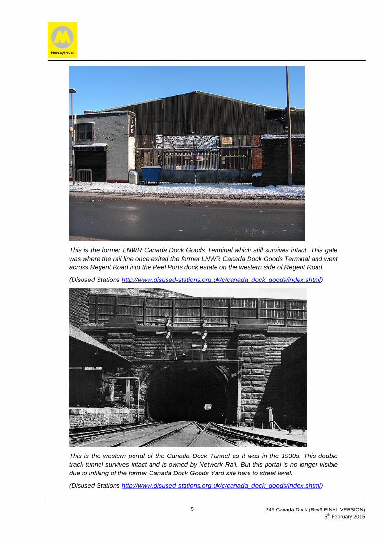
5
245 Canada Dock (Rev6 FINAL VERSION)
5th February 2015
This is the former LNWR Canada Dock Goods Terminal which still survives intact. This gate
was where the rail line once exited the former LNWR Canada Dock Goods Terminal and went
across Regent Road into the Peel Ports dock estate on the western side of Regent Road.
(Disused Stations http://www.disused-stations.org.uk/c/canada_dock_goods/index.shtml)
This is the western portal of the Canada Dock Tunnel as it was in the 1930s. This double
track tunnel survives intact and is owned by Network Rail. But this portal is no longer visible
due to infilling of the former Canada Dock Goods Yard site here to street level.
(Disused Stations http://www.disused-stations.org.uk/c/canada_dock_goods/index.shtml)

6
245 Canada Dock (Rev6 FINAL VERSION)
5th February 2015
3. Study Requirements
3.1 Merseytravel, on behalf of key stakeholders, wishes to commission a
Consultant to undertake a high level Feasibility & Demand Study for the
construction of a rail connection into Canada Dock and the Port of
Liverpool (Southern Zone). This work will involve identifying and
quantifying the capital costs (including land or lease costs), revenue
cost, operational aspects and constraints and demand for the route
options and scenarios for rail connectivity that are outlined.
3.2 The capital costs shall be based on typical high level industry rates
applied in relation to the Consultant’s knowledge of the area. Where
there are conditions that are unknown the Consultant shall apply a
reasonable assumption to the development of the cost and consider
upper and lower bounds. The uncertainties in cost will be developed
into a sensitivity analysis for each of the options with, median, upper
and lower bound costs being prepared. The Consultant shall provide
sufficient detail to show how costs are derived and demonstrate that
these are robust with appropriate historic or other documentary
evidence in support.
3.3 The Consultant shall list all the assumptions made in developing the
costs and identify the work that can be undertaken, if required or
appropriate, at a future date, so as to provide better cost certainty.
3.4 The Revenue Costs shall include any charges and costs incurred in the
provision of the rail freight service and any operational costs associated
with the freight handling facility. The costs should be based on typical
industry rates. The Consultant shall provide sufficient detail to show
how costs are derived and demonstrate that these are robust with
appropriate historic or other documentary evidence in support. This will
need to be informed also by the likely commodities and tonnages likely
to be handled by rail from this part of the Port of Liverpool.
3.5 Revenue Costs shall also include any savings associated with reducing
the road transport element as well as potential carbon savings.
3.6 The Consultant shall consider the options suggested and carry forward
only those that are considered acceptable in terms of operations.
Acceptable in this context means that Freight Operators would be able
to develop an operating pattern that is in accordance with normal
industry practice and is reasonably practical to implement.
3.7 The Consultant shall develop freight paths in and out of the proposed
rail freight terminal(s) for each of the options. This shall be considered
with the current timetables and any constraints that apply. Freight

7
245 Canada Dock (Rev6 FINAL VERSION)
5th February 2015
paths will look at local constraints as well as the path to the
origins/destinations. The demand study side of the work and likely
commodities will inform this element in terms of potential
origins/destinations. Current road transport and origins/destinations out
of the dock area shall also be considered. This element of the study is
intended to be a high level study with the primary focus being on a
detailed consideration of local constraints to freight movement.
Additionally it will include a secondary focus on a less detailed overview
of potential constraints further afield to possible origins/destinations.
3.8 The Consultant shall develop a demand model that considers current
usage of the dock area and develops this to identify any current and
increasing demand with the provision of these new rail freight facilities.
3.9 The capital cost shall include land purchase costs or amendments to
current leases. The Consultant will need to highlight those land parcels
that are likely to be impacted upon as a result of the proposed rail link
options. This will enable the key stakeholders to consider further any
impacts on occupiers with leases within the port estate and elsewhere
in a sensitive manner. The costs should be based on typical land costs
in the area. The Consultant shall provide sufficient detail to show how
these costs are derived and demonstrate that these are robust with
appropriate historic or other documentary evidence in support.
3.10 The Consultant shall also undertake the following as part of the study.
A high level review of the existing infrastructure in terms of constraints
to implementing the options and the works required to remove
constraints.
An overview feasibility of undertaking the works to implement the
individual options with high level risks identified.
A detailed comparison of the various infrastructure options detailing
risks, benefits, and relevant merits of each of the proposals, with the
preferred option clearly identified as a way forward.
Consider fully any planned infrastructure improvements in the area
including highway improvements, e.g. the planned improvements to
Regent Road by Liverpool City Council, and Peel Ports proposed
Langton In-River Ro-Ro Terminal, ensure any improvements are
integrated into option development for the Canada Dock rail links
The study shall consider known and planned local growth and shall
consider the opportunity to link in with other business in the location.
Likely terminal locations will depend on the cargo requirements of
existing and future businesses located in the port estate and local area.

8
245 Canada Dock (Rev6 FINAL VERSION)
5th February 2015
Provide relevant advice on further studies required to remove
unknowns, reduce risks or develop more robust costs.
Outline timescales for the potential implementation of the preferred
route option with key milestones including land acquisition, planning,
Network Rail procedures and the like.
High level consideration of the wider economic benefits such as
potential impacts on, local job and wealth creation, on the local Gross
Value Added (GVA) and improved accessibility to business.
High level consideration of environmental effects of options required
including any positive or negative impacts on the reduction of accidents
as well as noise, carbon and air quality improvements as a result of
removing freight from the roads and other relevant issues.
A high level consideration of benefits to other stakeholders.
Risks associated with the options and any necessary sensitivity
analysis to quantify the risks.
High level overview of the policy context and business aspirations for
the area of the Port of Liverpool and related port businesses with
leases in the area (particularly in port estate south of Alexandra Dock
including Langton Dock, Brocklebank Dock, Canada Dock, Huskisson
Dock and Sandon Dock in the Port of Liverpool Southern Zone).
Liaison with the stakeholders to understand and quantify the land and
lease constraints, identify the likelihood of approval of a level crossing
and the potential for taking the public highway into private ownership.
Qualitative analysis of the options and related benefits with a
commentary on the results with a specific focus of the necessity or
desire of a rail connection as appropriate to the findings of the study.
Drawing showing land ownership boundaries and detailed data of
ownership for the options evaluated.
Calculate Net Present Value (NPV) and Benefit Cost Ratios (BCR)
utilising WEBtag guidance in so far as this is possible or relevant.
Identify a preferred route option and indicative timescale for
implementation of this route option and suggest likely next steps.

9
245 Canada Dock (Rev6 FINAL VERSION)
5th February 2015
3.11 There are a number of separate infrastructure options to consider. The
map on p12 shows an overview of the two main route scenarios.
ROUTE A: New dedicated rail link off Bootle Branch to Canada Dock
and various other docks within the Port of Liverpool Southern Zone
Option A1:
This option includes the following elements –
Reinstate points at the former Atlantic Dock Junction between
Westminster Tunnel and Oriel Road Tunnel on the Bootle Branch;
project will need to provide a trailing crossover at the reinstated
Atlantic Dock Junction, for trains departing Canada Dock area of port
to allow them to access the Up Bootle Branch, (this is likely to
involve three point ends in total).
All new and modified signalling as necessary to facilitate rail link
Re-commission Canada Dock Tunnel under Leeds Liverpool Canal
with single or double track line reinstated as necessary
New single or double track line as necessary from tunnel to run
parallel to Bankfield Street with new or revived crossings under Bank
Hall Lane and Derby Road. These two roads historically were carried
over the former Canada Dock goods yard on multiple arched bridges
which may still be intact. Rail alignment should be future proofed to
cater for implementation of a double track capability if necessary.
Single or double track as necessary from terminal to buffer stop
Suitable length of track with associated sets of points to allow typical
freight train length and to allow loco to run around
Termination to the east of Regent Road with new freight terminal
created on part of the former LNWR Canada Dock goods yard site
including hard standing area suitable for cargo handling
Option A2
Option A2 is as per Option A1 but with the following additions:
Rail line extended into the port estate to west of Regent Road
through the creation of a level crossing of Regent Road before
curving northwards and / or southwards in the vicinity of the
Canada Dock area to serve the various docks as necessary.
Suitable length of track with associated sets of points to allow
typical freight train length and to allow loco to run around
Run around facilities within the Peel Ports estate to the west of
Regent Road and various freight terminals located as necessary
to serve the relevant port businesses and cargos. This will
enable the rail line to serve the Port of Liverpool (Southern

10
245 Canada Dock (Rev6 FINAL VERSION)
5th February 2015
Zone) including Sandon Dock, Huskisson Dock, Canada Dock,
Brocklebank Dock and Langton Dock.
Location of new freight terminal(s) within the port estate will
need to be informed by the port businesses and those in the
local area and the likely cargo / commodities.
Regent Road is to remain a public highway in this option. As a
result there will be a need to explore impact of level crossing on
the highway network and journey times in the area.
Option A3
This is as Option A2 except for the last point in regard to Regent Road:
Regent Road in this option is brought into the Peel Ports estate
and so will no longer be public highway but will become private.
This scenario for Regent Road is proposed in the medium to
long term by Peel Ports in the draft Mersey Ports Master Plan.
As a result there will be a need to explore impact of level
crossing on the highway network and journey times in the area.
Various combinations of the above options may also be worth
considering if the consultant feels this is necessary. For example there
may be merit in having both a freight terminal to east of Regent Road
on former Canada Dock Goods Yard site as well as ones to west within
the Peel Ports estate serving key docks in the southern part of the Port.
ROUTE B: Extension of rail lines within port estate southwards from
Alexandra Dock area to serve Canada Dock and Port of Liverpool
Southern Zone
Option B1:
This option includes the following elements –
New sets of points to the Bootle Branch and existing rail lines within
port estate close to Alexandra Dock to the west of Regent Road
New single or double track running to the west of Regent Road
within port estate or alternatively within or adjacent to the highway
itself in a southerly direction to buffer stops at Canada Dock or other
docks depending on cargos and needs of port businesses.
Hard standing area suitable for cargo handling
Suitable length of track with associated sets of points to allow typical
freight train length and to allow loco to run around

11
245 Canada Dock (Rev6 FINAL VERSION)
5th February 2015
Location of freight terminal(s) within the port estate will need to be
informed by the port businesses and those in the local area and the
likely cargo / commodities.
This option will need to examine the impact on rail capacity of the
existing rail lines within the port estate due to the shunting of trains
up to the northern end of port in this option from the southern end
that will be required prior to them exiting the port via Bootle Branch
Regent Road is to remain a public highway in this option. As a result
there will be a need to explore impact of rail line in this corridor on
the highway network and journey times in the area.
Option B2:
This is as option B1 except for the last point in regard to Regent Road –
Regent Road in this option is brought into the Peel Ports estate and
so will no longer be public highway but will become private. This
scenario for Regent Road is proposed in the medium to long term by
Peel Ports in the draft Mersey Ports Master Plan. As a result there
will be a need to explore impact of rail line in this corridor on the
highway network and journey times in the area.
ROUTE C: Do nothing approach and retain the status quo This option includes the following elements –
Do not proceed with any rail link to this part of port and accept the consequent limits on rail access and impact on the ability to promote multi-modal access to the Port of Liverpool.
Current safeguarding provisions are retained indefinitely

12
245 Canada Dock (Rev6 FINAL VERSION)
5th February 2015
Freight Rail Line to Port
of Liverpool Northern
Zone (Alexandra Dock
to Royal Seaforth Dock)
Merseyrail to Southport
and disused North
Mersey Branch to
Aintree and Ormskirk
FREIGHT ONLY
Bootle Branch
from Port of
Liverpool to
Chat Moss Line
and the WCML
Merseyrail to
Ormskirk and
Kirkby
Merseyrail to
Liverpool Central
and Hunts Cross
Port of Liverpool
Southern Zone (Langton
Dock to Sandon Dock)
NOT RAIL CONNECTED
Seatruck Ferries
Ro-Ro Terminal
at Langton Dock Southern Zone
Millers Bridge
Bankfield Street
Regent Road
A565
Derby
Road
Leeds
Liverpool
Canal
Northern Zone
13
245 Canada Dock (Rev6 FINAL VERSION)
5th February 2015
3.12 Freight movement by rail out of the Canada Dock area and other docks
in the Port of Liverpool (Southern Zone) cannot currently take place so
new freight paths will need to be identified as part of this study to
enable the trains to go onto the Bootle Branch and beyond. This will
need to take into account the rail freight forecasts for the Port of
Liverpool (Northern Zone) which predict 38 freight trains per day
outbound from the Port of Liverpool via the Bootle Branch (therefore 76
train movements in total overall including outbound and inbound).
3.13 Key stakeholders include:
Merseytravel
Liverpool City Region Local Enterprise Partnership
Sefton Council
Network Rail
Homes & Communities Agency (HCA)
Liverpool City Council
Peel Ports
Various Freight Operators
All businesses in and adjacent to the port estate, particularly in the
Port of Liverpool (Southern Zone) which is currently not rail
connected i.e. the area encompassing Langton Dock, Brocklebank
Dock, Canada Dock, Huskisson Dock and Sandon Dock that are all
located south of Alexandra Dock in the Port of Liverpool.
3.14 The Consultant shall facilitate and manage an inception meeting
presenting an understanding of the brief. The Consultant shall produce
a brief report following this meeting confirming his approach and
understanding. This report shall include a programme
3.15 The Consultant shall produce a two weekly headline progress report
detailing completion of items against programme and highlighting any
issues and developing risks to the programmed service.
3.16 The Consultant shall plan to produce and issue a draft report for
comment followed by facilitating and managing a meeting to review the
content of the draft report. The Consultant shall record all comments
made and detail actions based on comments.
3.17 The Consultant shall issue the final report following comments. The
Consultant shall present the findings to the stakeholders to be
facilitated and managed by the Consultant.

14
245 Canada Dock (Rev6 FINAL VERSION)
5th February 2015
3.18 The Consultant should be aware that the indicative headline budget for
this study work should not exceed £30,000 if possible.
4. Deliverables
4.1 Inception meeting summary.
4.2 Agreed and revised programme following inception meeting.
4.3 Draft Report.
4.4 Final Report.
5. Timescales
5.1 The Consultant shall provide a programme following the inception
meeting on 27 February 2015.
5.2 The Consultant shall complete the work in accordance with this
programme which shall be for completion of the draft report by end of
March 2015 and completed final report by end of April 2015.
5.3 The study is intended to provide outline baseline data to determine the
future direction for work in this area and is intended to be a high level
study. All data produced should be based on evidenced data with
assumptions clearly identified.
6. Project Management
The Consultant shall maintain a single point of contact throughout the
contract. Merseytravel shall identify a single point of contact following award.
7. Report Content
The precise format, layout and sections are as determined by the Consultant.