rail station fact sheet medpark station
TRANSCRIPT
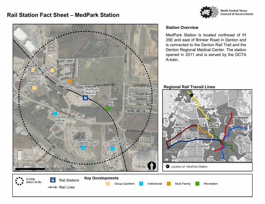
Station Overview
MedPark Station is located northeast of IH
35E and east of Brinker Road in Denton and
is connected to the Denton Rail Trail and the
Denton Regional Medical Center. The station
opened in 2011 and is served by the DCTA
A-train.
Regional Rail Transit Lines
Rail Station Fact Sheet – MedPark Station

Rail Station Fact Sheet – Medpark Station
Station Characteristics1 Station Area Characteristics (1/2 mile radius)
Address 3220 Medpark Drive Demographics3
City Denton Total Population 14,731
Agency Denton County Transportation Authority Population Density (pop/sq. mile) 1,606
Rail Line(s) A-train Average Median Age 29
Corridor DCTA A-train Average Median Income $50,955.00
Year Opened 2011
Park & Ride Spaces 716 Housing3
Total Housing Units 6,140
Ridership1 Housing Density (units/sq. mile) 669
2015 Avg. Weekday 197 Percent Occupied 93%
2015 Avg. Saturday 51 Percent Owner-Occupied 42%
2015 Avg. Sunday N/A Percent Renter-Occupied 58%
2014 On-Board Transit Survey: Access Mode to Station2 Commute To Work3
Bike 0.0% Percent Automobile 90.1%
Drive Alone 17.9% Percent Drive Alone 76.6%
Carpool 0.0% Percent Carpool 13.4%
Walk 67.1% Percent Transit 1.6%
Drop Off 11.3% Percent Bike 0.0%
Other 0.0% Percent Walk 3.1%
Transit Transfer 3.8% Percent Other 1.8%
Percent Work from Home 3.5%
Station Area Plans and Studies Percent Zero-Vehicle Households 7.4%
Title
Publisher Traffic Survey Zone 2017 Employment Forecast2
Year Total Jobs 8,639
Web Location Job Density (jobs/sq. mile) 1,509
Sources: 1.Denton County Transportation Authority (DCTA), 2. NCTCOG, 3. U.S. Census American Community Survey 5-year estimates (2010-2014) by block group
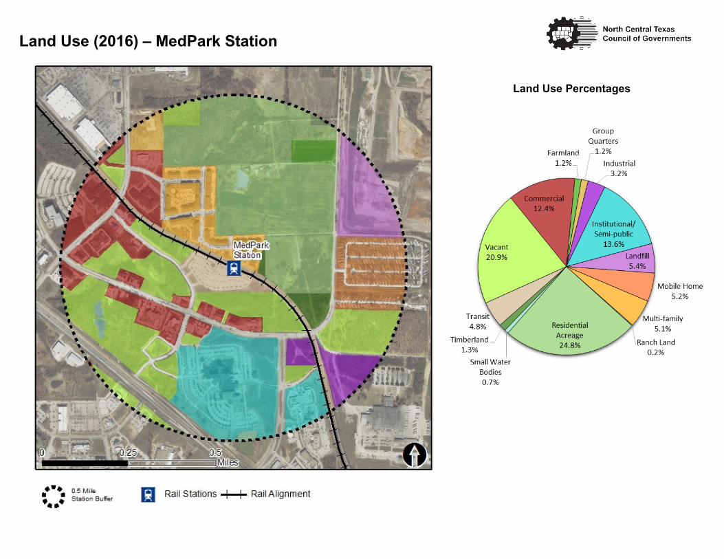
Land Use (2016) – MedPark Station
Land Use Percentages
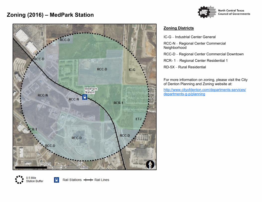
Zoning Districts
IC-G – Industrial Center General
RCC-N – Regional Center Commercial Neighborhood
RCC-D – Regional Center Commercial Downtown
RCR- 1 – Regional Center Residential 1
RD-5X – Rural Residential
For more information on zoning, please visit the City of Denton Planning and Zoning website at:
http://www.cityofdenton.com/departments-services/departments-g-p/planning
Zoning (2016) – MedPark Station

MedparkStation
MAYH
ILL
COLORADO
BRIN
KER
MEDPARK LEAFY
EDWARDS
WIND RIVER
BLOOM
QUAILCREEK
CANARY
BLUE JAY
QUAIL CREEK
HUDSONWOOD
UNICORN LAKE
BERR
Y DOW
N
35E
MAYH
ILL
BRINKER
The Pedestrian Routes to Rail study identifies allexisting pedestrian facilities within a half-mile radiusof existing light rail and commuter rail stations in theDallas-Fort Worth region based on 2014 data.ArcGIS Network Analyst tool was used to identifycontinuous facilities that are less than or greaterthan a half-mile actual walking distance to a station.The maps also reflect existing facilities that aredisconnected due to gaps or other barriers notallowing a continuous pedestrian route to a station.The maps do not reflect the condition or ADAcompliance of the existing infrastructure. Moreinformation on the Routes to Rail study andmethodology is available at:
Project Overview
Pedestrian Routes to Rail - Medpark Station
0 0.50.25Miles
LegendRail Stations
RailroadsExisting sidewalk facilities within a0.5 mile walk distanceExisting sidewalk facilities greater thana 0.5 mile walk distanceExisting sidewalk facilites that aredisconnected due to a gap in thenetwork
nctcog.org/RoutesToRail
0.5 Mile Station Buffer
Last Updated: February 2015
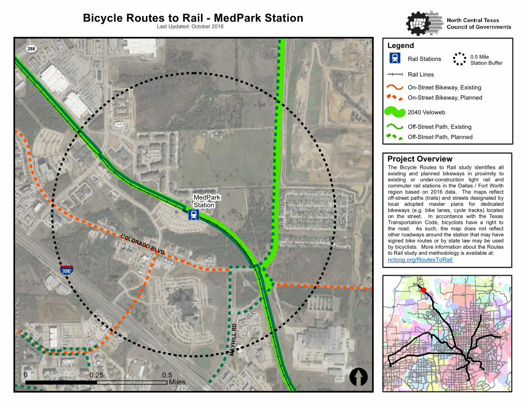
The Bicycle Routes to Rail study identifies allexisting and planned bikeways in proximity toexisting or under-construction light rail andcommuter rail stations in the Dallas / Fort Worthregion based on 2016 data. The maps reflectoff-street paths (trails) and streets designated bylocal adopted master plans for dedicatedbikeways (e.g. bike lanes, cycle tracks) locatedon the street. In accordance with the TexasTransportation Code, bicyclists have a right tothe road. As such, the map does not reflectother roadways around the station that may havesigned bike routes or by state law may be usedby bicyclists. More information about the Routesto Rail study and methodology is available at:
Project Overview
I2MA
YHI LL
RDCOLORADO BLVD
ST288
[\̂35E
MedParkStation
[0 0.50.25Miles
I2 Rail Stations
Rail LinesOn-Street Bikeway, ExistingOn-Street Bikeway, Planned
2040 Veloweb
Off-Street Path, ExistingOff-Street Path, Planned
0.5 MileStation Buffer
Bicycle Routes to Rail - MedPark StationLast Updated: October 2016
nctcog.org/RoutesToRail
Legend