reactive monitoring mission to mapungubwe cultural landscape
TRANSCRIPT

0
World Heritage Patrimoine mondial
36 COM
Distribution limited / limitée Paris, 11 June/11 juin 2012 Original: English
UNITED NATIONS EDUCATIONAL, SCIENTIFIC AND CULTURAL ORGANIZATION
ORGANISATION DES NATIONS UNIES POUR L'EDUCATION, LA SCIENCE ET LA CULTURE
CONVENTION CONCERNING THE PROTECTION OF THE WORLD CULTURAL AND NATURAL HERITAGE
CONVENTION CONCERNANT LA PROTECTION DU PATRIMOINE MONDIAL, CULTUREL ET NATUREL
WORLD HERITAGE COMMITTEE / COMITE DU PATRIMOINE MONDIAL
Thirty-sixth session / Trente-sixième session
Saint Petersburg, Russian Federation / Saint Pétersbourg, Fédération de Russie
24 June – 6 July 2012 / 24 juin – 6 juillet 2012
Item 7 of the Provisional Agenda: State of conservation of properties inscribed on the World Heritage List and/or on the List of World Heritage in Danger. Point 7 de l’Ordre du jour provisoire: Etat de conservation de biens inscrits sur la Liste du patrimoine mondial et/ou sur la Liste du patrimoine mondial en péril
MISSION REPORT / RAPPORT DE MISSION
Mapungubwe Cultural Landscape (South Africa) (C1099)/ Paysage culturel de Mapungubwe (Afrique du Sud) (C 1099)
15-20 January 2012/15-20 janvier 2012
This mission report should be read in conjunction with Document: Ce rapport de mission doit être lu conjointement avec le document suivant:
WHC 12/36. COM/7B.Add
0
Mission Report
Reactive Monitoring Mission to Mapungubwe Cultural Landscape
World Heritage Property (South Africa) 15 – 20 January 2012
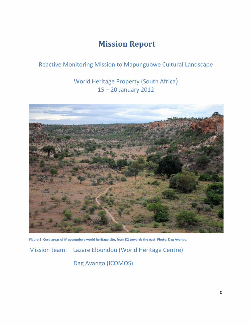
Figure 1. Core areas of Mapungubwe world heritage site, from K2 towards the east. Photo: Dag Avango.
Mission team: Lazare Eloundou (World Heritage Centre)
Dag Avango (ICOMOS)

1
Table of contents
Contents Mission Report ............................................................................................................................. ................. 0
Table of contents........................................................................................................................................... 1
Acknowledgements ....................................................................................................................................... 4
1. Background to the reactive monitoring mission January 2012................................................................. 5
1.1 Main mission objectives ...................................................................................................................... 5
1.2 Background information to consider .................................................................................................. 6
1.3 Terms of reference of the 2012 Reactive Monitoring Mission ........................................................... 8
2. Results ....................................................................................................................................................... 9
2.1. Inspection of the Vele mining area .................................................................................................. 10
2.1.1 Archaeological site 12 or 13 (HIA 2011:57) ................................................................................ 11
2.1.2 Limpopo river ............................................................................................................................. 12
2.1.3 The open cast mining area ......................................................................................................... 13
2.1.4 Processing plant ......................................................................................................................... 16
2.1.5. General overview of the Vele mining area ................................................................................ 18
2.2. Inspection of Mapungubwe cultural landscape core area ............................................................... 20
2.2.1. Schroda archaeological site ....................................................................................................... 20
2.2.2. K2 archaeological site ................................................................................................................ 21
2.2.3. Mapungubwe hill....................................................................................................................... 22
2.2.4 Mapungubwe cultural landscape World Heritage Site core area – general observations and
remarks................................................................................................................................................ 23
2.3. Stakeholder meetings.................................................................................. ..................................... 28
2.3.1. Meeting with leaders of local communities .............................................................................. 28

2
2.3.2. Meeting with representatives of NGO’s.................................................................................... 31
2.3.3. Comments on the HIA by the ICOMOS and UNESCO reactive monitoring mission .................. 34
3. Conclusions.............................................................................................................................................. 39
3.1. Resumption of mining ................................................................................... ................................... 39
3.2. Open cast and Underground Mining areas ...................................................................................... 39
3.3. Impact of the mining of the OUV of the property............................................................................ 40
3.4. Possible Mitigation Measures .......................................................................................................... 41
3.5. Relationship with local communities & NGOs.................................................................................. 41
3.6. Protection of the setting of the property and the effectiveness of the buffer zone ....................... 41
3.7. Further threats from mining activities in the Buffer Zone ............................................................... 42
3.8. Mining infrastructures within the property ..................................................................................... 42
3.9. State of Conservation of the property; K2 site and water extraction plants ................................... 42
4. Recommendations................................................................................................................................... 42
5. Detailed Recommendations .................................................................................................................... 44
5.1. Secure the buffer zone ..................................................................................................................... 44
5.2. The issuing of new prospecting licences in the buffer zone of the Map.CL. WHS ........................... 44
5.3. Ensure that local communities are consulted and included ............................................................ 45
5.4. A comprehensive 3‐5 years monitoring program ............................................................................ 45
6. Appendices .............................................................................................................................................. 47
6.1. Comments on Heritage Impact Assessment by the Association of Southern African Professional
Archaeologists (ASAPA) on 30 January 2012........................................................................................... 47
1. Introduction..................................................................................................................................... 47
2. General remarks .............................................................................................................................. 48
3. Impact on Sense of Place and Outstanding Universal Values (OUVs) ............................................. 48
4. Buffer Zone ...................................................................................................................................... 49
3
5. Community consultation ................................................................................................................. 50
6. Unauthorised damage to site .......................................................................................................... 51
7. Stakeholder engagement ................................................................................................................ 51
8. Missing / insufficient data / studies ................................................................................................ 53
9. Comments on the study Historiography and Traditional dispensation of Mapungubwe: Vele
Colliery and surrounding communities. .............................................................................................. 54
10. Documents consulted.................................................................................................................... 54
11. Technical comments...................................................................................................................... 54
12. Key factual errors in the report ..................................................................................................... 55
13. Comments on key recommendations ........................................................................................... 56
14. Monitoring & management.......................................................................................................... 57
15. Mitigation ...................................................................................................................................... 58
16. Heritage conservation and the MCL WHS core and buffer ........................................................... 59
17. Suggestions regarding Heritage Management in the MCL beyond Vele colliery .......................... 60
6.2. STATE PARTY’S ADDRESS TO THE UNESCO/ ICOMOS REACTIVE MONITORING MISSION ............... 61
Preamble ............................................................................................................................. ................ 61
Findings and Recommendations of the Heritage Impact Assessment ................................................ 62
Clarification of the buffer zone. .......................................................................................................... 62
Memorandum of Agreement between the state party and the mining company. ............................ 63 6.3 Retrospective Statement of OUV ..................................................................................................... 63
Brief synthesis ..................................................................................................................................... 63
6.4 Report from Vhangona cultural movement on the interaction between their community and Coal
of Africa ................................................................................................................................................... 67
6.5. Map plans of Vele Colliery ................................................................................................................ 92
4
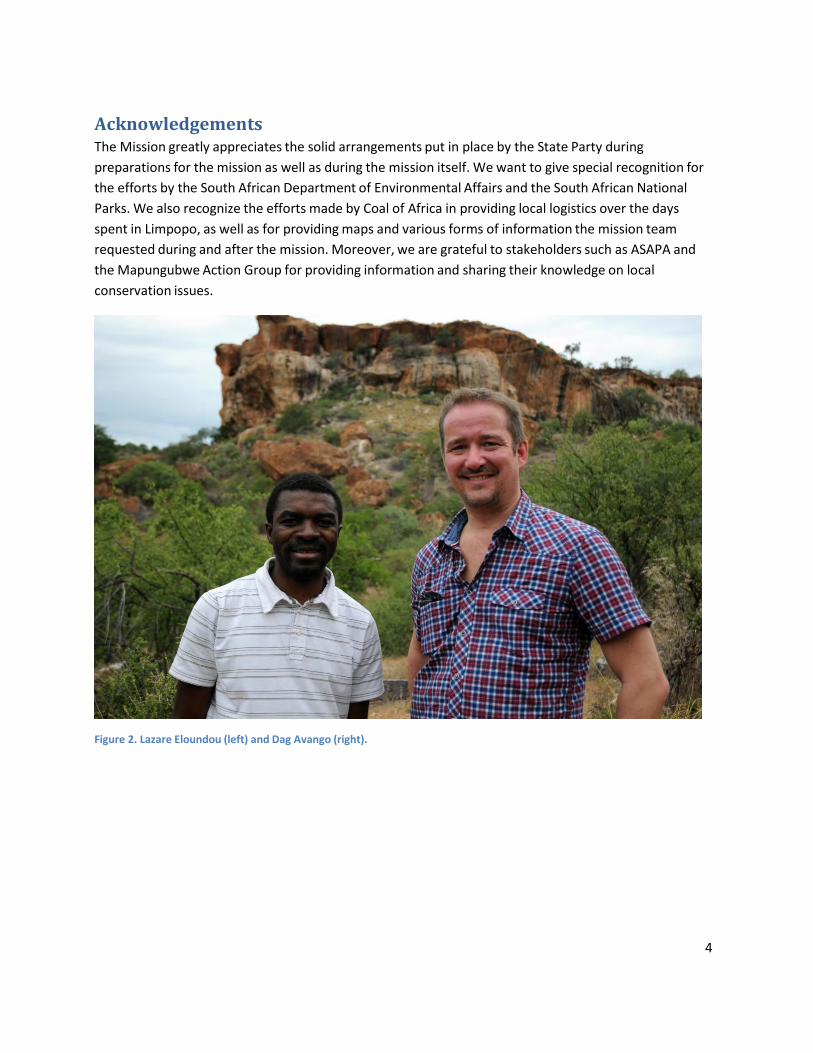
Acknowledgements The Mission greatly appreciates the solid arrangements put in place by the State Party during
preparations for the mission as well as during the mission itself. We want to give special recognition for
the efforts by the South African Department of Environmental Affairs and the South African National
Parks. We also recognize the efforts made by Coal of Africa in providing local logistics over the days
spent in Limpopo, as well as for providing maps and various forms of information the mission team
requested during and after the mission. Moreover, we are grateful to stakeholders such as ASAPA and
the Mapungubwe Action Group for providing information and sharing their knowledge on local
conservation issues.
Figure 2. Lazare Eloundou (left) and Dag Avango (right).

5
1. Background to the reactive monitoring mission January 2012
Figure 3. Core area of Mapungubwe national park, from Mapungubwe hill towards the west. Photo: Dag Avango
In accordance with decision 35 COM 7B.44, the World Heritage Centre (WHC) and ICOMOS undertook a
joint reactive monitoring mission to Mapungubwe Cultural Landscape, in South Africa from January 17 to
21 in 2012. The WHC received the invitation on 17 September 2011 from the State Party as requested by
paragraph 9 of Decision 35 COM 7B.44.
1.1 Main mission objectives The main mission purpose was to assess the progress made in the implementation of the
recommendations made by a previous reactive monitoring mission made in November 2010, with
particular attention to:
1) The additional Heritage Impact Assessment requested in order to assess the potential impact of
the proposed large scale coal mining to the east of the property on the cultural attributes of the
property that convey OUV. The HIA report was submitted by the Department of Environmental
Affairs on 25th November 2011.
2) Putting in place a buffer zone to the east of the property, as identified at the time of inscription
3) Consider the overall state of conservation of the property.

6
The mission team was composed of Dr. Dag Avango, ICOMOS, and Mr. Lazare Eloundou, UNESCO WHC,
assisted by representatives of the DEA of South Africa. Dr. Dag Avango is a researcher at the Division of
History of Science, Technology and Environment, Royal Institute of Technology in Sweden and is
specialized in the history large scale natural resource extraction, in particular mining and its societal and
environmental impacts. Lazare Eloundou is a conservation architect specialised on World Heritage issues
in Africa.
1.2 Background information to consider The mission considered the following main background information:
2003: The site of Mapungubwe was inscribed on the World Heritage List in March 2003, on the basis of
criteria ii, iii, iv and v. In the 2003 ICOMOS evaluation report three issues were raised:
1) Buffer Zone boundaries needed to be addressed to comply with ICOMOS recommendations at
the time of the inscription.
2) Limpopo – Shashe Transfrontier Conservation Area (TFCA), with the neighbouring countries
needed to be defined as this was stated in the nomination dossier as providing an extra layer of
protection beyond the Buffer Zone.
3) Mining and agricultural operations around the site having a minor impact had to be kept under
control.
2010: The World Heritage Committee at its 34th Session (Brasilia, 2010), after being alerted about the
granting of the mining permit to Coal of Africa Ltd, requested a joint World Heritage Centre/ ICOMOS
reactive monitoring mission.
The joint World Heritage Centre/ ICOMOS reactive monitoring mission took place between 13 and 17
November 2010. The mission conducted an aerial survey by helicopter over the Vele colliery, the buffer
zone area ‐ including the Venetia mine – as well as the core area of the world heritage site. The mission
was also taken on a tour to a number of sites within the Vele colliery area. Moreover, the mission
conducted meetings with a wide and representative range of stakeholders (State Party, Mining interests,
Civil Society and NGO´s, Community leaders and land claimants). The mission also studied maps and plans
pertaining to the mining plans of Coal of Africa Ltd.
The mission submitted a report in which it voiced its concerns regarding different issues. Based on the
aerial survey, the report was concerned by the continued existence of producing citrus farms within the
buffer zone, the presence of wetlands along the Limpopo River that needs protection and the presence
of mining sites within the buffer zone and the proposed Limpopo/Shashe Transfrontier Conservation
Area (from here on TFCA) – the Venetia mine of the mining company De Beers and the Tuli coal mine in
Zimbabwe across the Limpopo river.
Based on the inspection of the Vele colliery area, the report described the mining activities which at the
time had been halted while awaiting further assessment of the impacts of mining on the world heritage
site. The mission was un‐satisfied with a lack of consensus regarding the prevailing wind direction at the
7
mining site and thus the direction of the drift of dust which will result from open pit mining. The mission
did however voice some satisfaction with the set‐up of the production process at the colliery processing
plant, the mining company’s decision to cancel a previous plan to build a power station at the colliery
and the fact that whatever system Coal of Africa would build to transport coal, would take the coal in the
direction of Musina – not towards the world heritage site core area.
The mission report also presented the results of stakeholder meetings. The state party had expressed
commitment to secure a buffer zone around the core area of Mapungubwe cultural landscape, as well as
to move forward in establishing the TFCA. The State Party underscored the latter as particularly important
in order to secure a buffer zone east of the Mapungubwe cultural landscape core area. As a first step the
State Party committed to quickly identifying the land owners in this area.
The missions reported that Coal of Africa perceived that their mining operations at Vele would pose no
threats at all to the World Heritage property and claimed that they have and will continue to put in place
mitigatory measures to protect the environment and support research efforts. An identical view had
been presented by the specialists who produced Coal of Africa´s Environmental Impact Assessment. The
Mission observed that the specialists commissioned by CoAL passionately advocated the position of
CoAL and did not present possible alternative scenarios.
The civil societies and NGO´s expressed strong criticism to the mining plans at Vele and warned of dust
pollution of water supplies, air and cultural heritage because of prevailing easterly winds. In addition they
reported that other mining companies, such as Anglo‐Coal, has followed in the foot‐steps of Coal of Africa
and applied for mining rights in the buffer zone of the world heritage site. The NGO´s also complained
about not having been consulted on the issue of mining. Community representatives and land claimants
were also highly critical of the mining project and the way it had been conducted so far. Their position
was that:
1) There should be adequate consultation in order to obtain informed consent. To do so, the
community leadership insisted on being adequately informed, particularly with respect to the
impact of mining on the cultural and natural heritage values of the property.
The report commented that it is an a priori condition of EIA’s that all relevant stakeholders be
part of the EIA process. It is in this case, also a requirement in terms of the MOU of TFCA.
2) All parties, whether in favour or opposed to the mining venture, were united on the opinion that
any venture should not negatively impact their natural and cultural environment.
Based on these results, the mission report expressed the view that the State Party should take on board
traditional knowledge expertise in the peer review process, especially in relation to the anthropological
aspects.
Further, the 2010 mission gave the following main recommendations to the State Party in its mission
report:
8
1) As a result of the fact that the delimitation of the buffer zone provided by the State Party, did not
include the zone east of the World Heritage site core area: “It is clear that the current status does
not protect in an effective way the OUV of the property”. Therefore the mission recommends the
State Party to clarify the issue of the buffer zone, since its current extension does not match the
buffer zone envisioned in the original nomination dossier of 2003. The Mission recommended
clarification of this issue because it is central to the mining licence granted to CoAL. It also has
serious implications for other mining proposals understood to be in the pipeline.
2) The State Party needs to clarify progress made in consolidating the core zone through
acquisitions and agreements with private land holders, as per the commitments made in 2003.
3) Both the nomination dossier and the 2003 ICOMOS evaluation report underscore the importance
of the TFCA as an important buffering mechanism for both the core and buffer zones. The
mission expressed satisfaction with negotiations undertaken to establish the TFCA and
encouraged continued efforts.
4) Halt the mining activities until a HIA is conducted with the view to evaluate the impact of the
mining activity on the OUV of the property.
A Heritage Impact Assessment report was requested from the State Party.
2011: At the 35th Session of the World Heritage Committee (Paris 2011) the state of conservation of
Mapungubwe Cultural Landscape was examined. The joint WHC‐ICOMOS reactive monitoring mission of
January 2012 is a result of the decisions taken during the 35th session as prescribed in the Decision 35
COM 7B document.
1.3 Terms of reference of the 2012 Reactive Monitoring Mission The main tasks of the reactive monitoring mission in January 2012 were to:
1) Visit the property and observe if the mining activities has continued to be halted.
2) Hold working sessions with the responsible authorities and relevant stakeholders involved in the
issuing of the mining licence, as indicated in the paragraph 10 of the Decision 35 COM 7B.
3) Hold consultation sessions with the South African institutions and experts who worked on the
Heritage Impact Assessment report, for ICOMOS comments and eventual guidance.
4) In the event of the mission concluding that the proposed mining might not threaten irreversibly
the property's Outstanding Universal Value, provide guidance or hold further consultation
sessions, with the State Party, with regard to possible urgent mitigation measures and

9
monitoring programmes to allow the DG of UNESCO and the Chairperson of the WH Committee
to address this issue as requested in the paragraph 11 of the Decision 35 COM 7B.
5) Asses the state of conservation of the property, in particular all issues related to the
conservation and management of the overall cultural landscape as well as of the archaeological
sites within the landscape.
6) Submit a joint report highlighting the findings and recommendations of the Reactive Monitoring
Mission. The mission report will be prepared by ICOMOS with input of the WHC. The report
outlining the main results and recommendations to allow the World Heritage Committee at,
examine the property state of conservation at the 36th session in 2012.
2. Results
Figure 4. Dongola ranch (buffer zone), local headquarters of Coal of Africa. Photo: Dag Avango
The mission team arrived in Johannesburg – Dag Avango (ICOMOS) on the 16th of January and Lazare
Eloundou on the 17th of January. Assisted by the South African Department of Environmental Affairs
(DEA), the team travelled by car to Mapungubwe, in the Limpopo Province. The team was housed at a
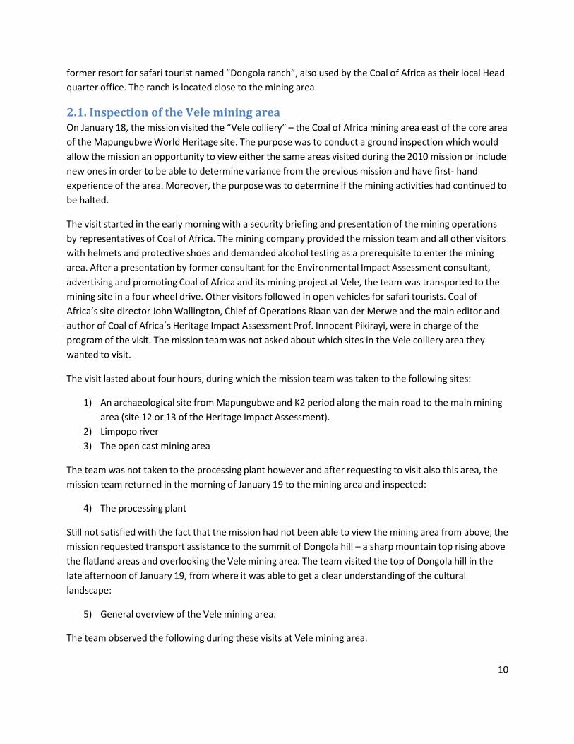
10
former resort for safari tourist named “Dongola ranch”, also used by the Coal of Africa as their local Head
quarter office. The ranch is located close to the mining area.
2.1. Inspection of the Vele mining area On January 18, the mission visited the “Vele colliery” – the Coal of Africa mining area east of the core area
of the Mapungubwe World Heritage site. The purpose was to conduct a ground inspection which would
allow the mission an opportunity to view either the same areas visited during the 2010 mission or include
new ones in order to be able to determine variance from the previous mission and have first‐ hand
experience of the area. Moreover, the purpose was to determine if the mining activities had continued to
be halted.
The visit started in the early morning with a security briefing and presentation of the mining operations
by representatives of Coal of Africa. The mining company provided the mission team and all other visitors
with helmets and protective shoes and demanded alcohol testing as a prerequisite to enter the mining
area. After a presentation by former consultant for the Environmental Impact Assessment consultant,
advertising and promoting Coal of Africa and its mining project at Vele, the team was transported to the
mining site in a four wheel drive. Other visitors followed in open vehicles for safari tourists. Coal of
Africa’s site director John Wallington, Chief of Operations Riaan van der Merwe and the main editor and
author of Coal of Africa´s Heritage Impact Assessment Prof. Innocent Pikirayi, were in charge of the
program of the visit. The mission team was not asked about which sites in the Vele colliery area they
wanted to visit.
The visit lasted about four hours, during which the mission team was taken to the following sites:
1) An archaeological site from Mapungubwe and K2 period along the main road to the main mining
area (site 12 or 13 of the Heritage Impact Assessment).
2) Limpopo river
3) The open cast mining area
The team was not taken to the processing plant however and after requesting to visit also this area, the
mission team returned in the morning of January 19 to the mining area and inspected:
4) The processing plant
Still not satisfied with the fact that the mission had not been able to view the mining area from above, the
mission requested transport assistance to the summit of Dongola hill – a sharp mountain top rising above
the flatland areas and overlooking the Vele mining area. The team visited the top of Dongola hill in the
late afternoon of January 19, from where it was able to get a clear understanding of the cultural
landscape:
5) General overview of the Vele mining area.
The team observed the following during these visits at Vele mining area.

11
2.1.1 Archaeological site 12 or 13 (HIA 2011:57)
Figure 5. Prof. Innocent Pikirayi presenting archaeological site (Mapungubwe / K2) he recommends should be subject to salvage excavation. Photo: Dag Avango
The first visit took place at the archaeological site number 12 or 13 (HIA 2011:57), located within the Vele
mining area. Heritage Impact Assessment main author Prof. Innocent Pikirayi presented the site as an
example of archaeological sites in the mining area which, according to him, needed to become subject of
rescue excavation. The reason, Pikirayi stated, was its location at about 20 m from a service road (gravel)
to the mining area and the risk of damage from road works there in the future. Answering on a direct
question from the mission team, Pikirayi saw no possibilities to protect the site other than destroying it
through excavation. Instead he strongly advocated salvage excavation for this and a number of other
similar sites in the mining area. In the presence of the mining company director and the chief of
operations, Pikirayi emphasized that Coal of Africa will finance the salvage excavations and underscored
the value of those suggested salvage excavations for increasing our knowledge on the history of
Mapungubwe. These statements are similar to those presented by Pikirayi and his team in the Heritage
Impact Assessment (HIA 2011). The mission team are critical to this approach, which is further commented
in section 2.3.3 in this report.

12
2.1.2 Limpopo river
Figure 6. System of fences and barbed wires alongside the Limpopo River, originally built to restrict movement across the border with Zimbabwe. These fences still dominate the landscape by the river. Photo: Dag Avango
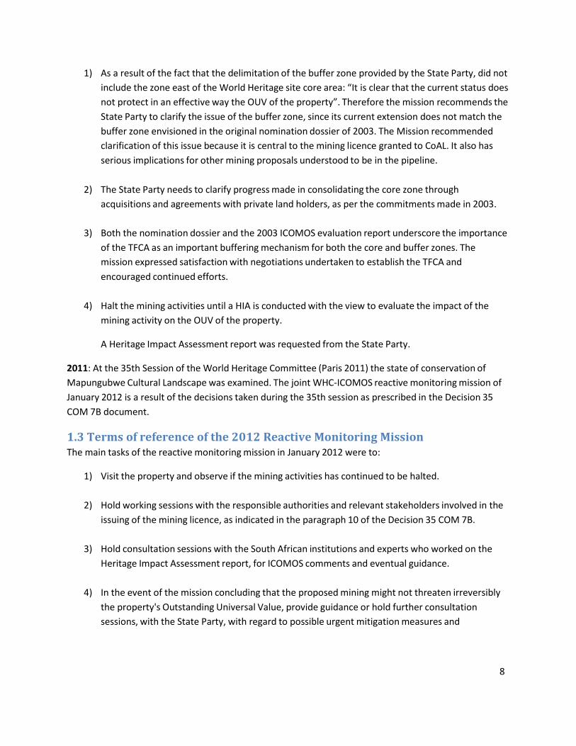
The mining operations as well as the processing plant at Vele require vast amounts of water. Coal of
Africa takes this water from Limpopo River and the mission team visited a water pumping site built by
the company along the river. The pumping station consisted of a number of pipes visible above ground at
a spot located approximately 50 meters from the river. In the vicinity nearby citrus farms are already
pumping out water for their watering needs. Apart from the river, the landscape of the area is
dominated by a massive system of fences and barbed wires following the river about 75 meters inland.
These fences were built in order to control movement across the border with Zimbabwe.
In this general context, the visual impact of the water intake on the cultural landscape is rather
insignificant. Seen as a whole, these structures are a part of time layer of the Mapungubwe cultural
landscape buffer zone that contrasts and conflicts with the OUV of the core area of the World Heritage
site. However the mission was concerned about the increasing number of water pumping sites which
could in a long term affect the integrity of the World Heritage site, by affecting the water table of
Limpopo River.
13
Figure 7. Water intake for the Vele colliery by Limpopo River. In the background the fence and barbed wire system along Limpopo River is visible. Photo: Dag Avango.
2.1.3 The open cast mining area
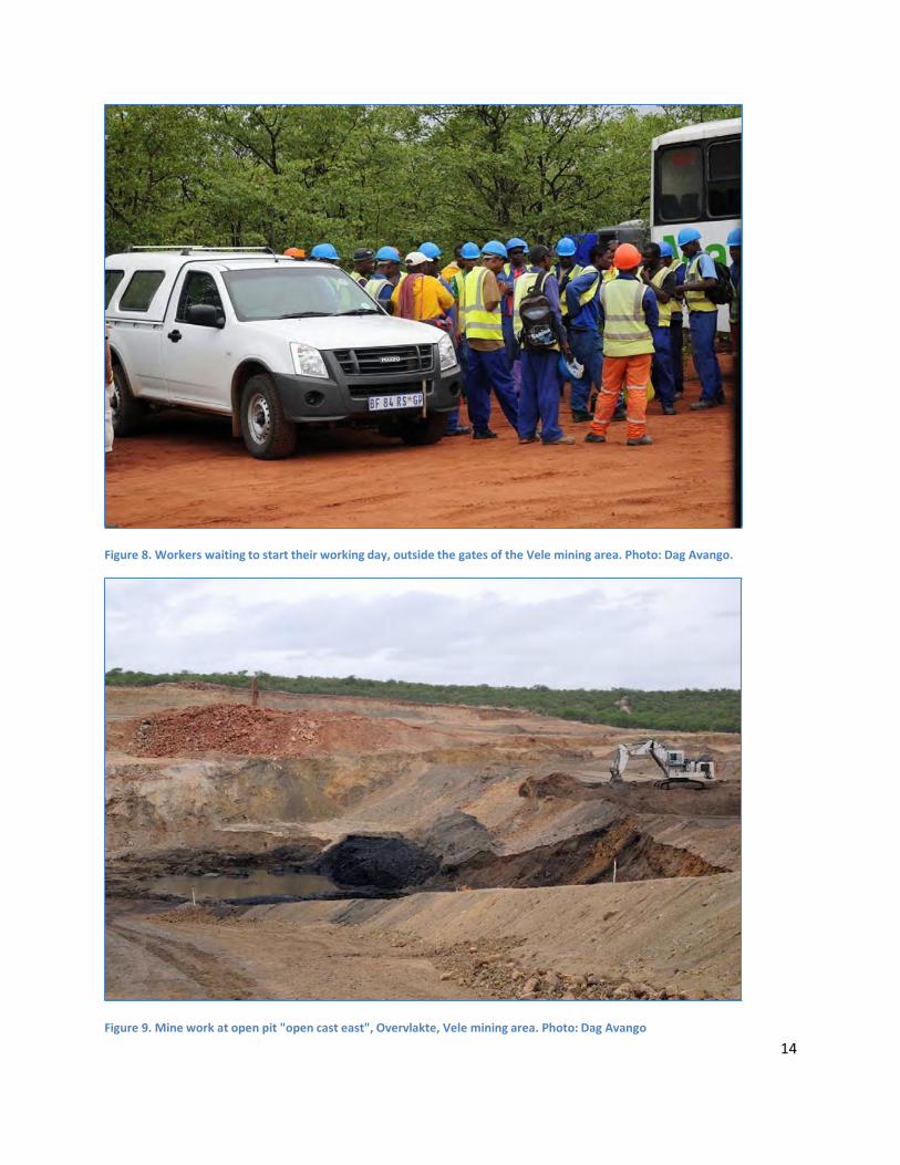
The visit at the open cast mining area revealed that Coal of Africa has conducted work at the mine since
the visit by the 2010 mission at the site. When the mission team asked Coal of Africa site director John
Wallington if the company had re‐started its mining operations, he confirmed that this was the case but
he stated also that mining operations had not been extended since 2010. According to John Wallington
and Riian van der Merwe, the company have been mining only within the footprint of the open pit area
which the company was operating at the time when it was ordered to stop its mining operations.
According to their statements, the Vele project would be ready to go in to full production by the end of
January 2012 and they presented the ambition to go in to full production on March 1 2012. At the time
of the mission team visit, there were 500 workers and engineers already recruited and working at the
site.
At the site, the mission team observed the traces of the recent mining works. However, when visiting the
mining area to inspect the processing plant the following day, the fact that Coal of Africa has resumed its
mining operations became crystal clear. By the gates of the mining areas, there were large amounts of
workers on their way in to the various work sites in the mining area.
14
Figure 8. Workers waiting to start their working day, outside the gates of the Vele mining area. Photo: Dag Avango.
Figure 9. Mine work at open pit "open cast east", Overvlakte, Vele mining area. Photo: Dag Avango

Figure 10. Western section of the open‐cast mining area. Photo: Dag Avango.
15
Operations manager, Riian van der Merwe answered all questions pertaining to the mining plans of Coal
of Africa at Vele. He repeated the same mining plan which the company has presented though previous
reports (EMP, EIA, HIA). Upon being asked by the mission team about the rationale behind Coal of
Africa’s decision to mine underground in the north‐west while mining open cast in the south‐east, Van
der Merwe answered that their choice was not motivated by the position of the coal seam in those areas.
The coal seam is located at more or less the same depth. Instead, their plan is motivated by the ambition
to avoid harming the big commercial citrus farms along Limpopo River. The inland areas to the
south and south‐west did not need such protective measure, because according to Coal of Africa, its only
dry bush land. This statement contrast with the otherwise stated ambitions by Coal of Africa to prioritize
cultural heritage protection at Vele.
Finally it should be noted that the open pit site which is at Vele colliery, in its current form, is only a
limited version of the open pit that Coal of Africa will move forward across the landscape once they put
their mining operations in to full speed. Yet, the visual impact of even this “small” intrusion in the
landscape is substantial and will not only destroy any cultural heritage showing up in its way, but will
obviously also modify the cultural landscape. Once the open cast mines are refilled and the bush
replanted, what remains will be a cultural landscape of coal mining, not a cultural landscape of the K2
and Mapungubwe periods. Therefore, the mission team does not agree with the statement of the HIA
that the impacts of mining at Vele on the OUV of Mapungubwe cultural landscape will be minimal.

16
2.1.4 Processing plant
Figure 11. Part of the processing plant of Vele Colliery. Photo: Dag Avango
The layout of the processing plant is, from what the mission team could judge, in accordance with the
plans presented previously by Coal of Africa (in EMP, EIA, HIA). The representatives of Coal of Africa
underscored the efforts they had made to reduce the visibility of the processing plant, by limiting its
maximum height to 40 meters. According to their statements, the plant was 95 % finished already in
November 2011.
The Coal of Africa representatives stated that the company has arranged belts of vegetation throughout
the processing plant area. While the mission team were indeed shown examples of this, the processing
plant area also gives an instructive example of the how the mining company views cultural heritage
protection in the Vele mining area. In the middle of the processing plant area, the company has fenced
off a patch of land said to contain archaeological remains (figure 12). The mission team was presented
the fenced patch as an example of what can be done to protect archaeological sites in the mining area –
a method also pointed out in the HIA as the way to go. However, from the mission team point of view,
the value of the archaeological site is gone forever, since it is surrounded by a vast industrial landscape
that has reshaped the historical landscape which the fenced in archaeological remains once formed a
part of. In the light of this site, it is difficult to share the optimism voiced by the HIA regarding the
possibilities to preserve the remaining attributes in the Vele colliery area that are associated with the
OUV of the property.

17
Figure 12. Fenced archaeological site at the processing plant area of Vele colliery. Photo: Dag Avango.
The visit at the processing plant made it clear that Coal of Africa has continued to develop also this site
since the mining operations were officially halted in 2010. According to Coal of Africa management team,
the production line will be ready to produce with full capacity by January 31 2012, and according to plan
be taken in to full production by March 1.
On the eastern side of the processing plant, the mission team observed the clearest evidence of the
already on‐going mining operations. On an area cleared from vegetation close to the plant, the mining
company has stored substantial amounts of coal, ready to be processed in the plant (figure 13).

18
Figure 13. Piles of coal recently mined at the open cast mining area, stored at Vele colliery processing plant. Photo: Dag Avango.
2.1.5. General overview of the Vele mining area
In order to get an overview from above over the Vele mining area, the mission team requested
assistance to get to the top of a hill situated nearby Gondola ranch. In the afternoon of January 19, the
mission team was transported by car to the hill top together with John Wallington and Riian van der
Merwe of Coal of Africa.
From the hill top it was possible to get an impression of the visual impacts of the mining activities at Vele
on the surrounding cultural landscape.
1) The most prominent feature of the area, at this stage of development, is the processing plant.
2) Another prominent feature is the new access road to the western open cast mining area and
processing plant
In addition, the mission team also observed features which the team had not been shown during the
tour of the mining area on January 19.
3) Landing strip. It was explained to the mission team that Coal of Africa had used an old dirt road
as the bases for the landing strip, by widening the road (figure 14).

19
Figure 14. Landing strip of Vele colliery, constructed by widening an existing gravel road. Photo: Dag Avango.
Figure 15. Vele mining area. In the left half of the photo, the processing plant and the access road are visible. On the right side of the lower half of the photo (west of the access road) is a patch where the bush has been cleared. Photo: Dag Avango.

20
4. Large clearing of bush west of the access road. When asked what the clearing was, Coal of Africa
answered that it was made by contractors and that they had been furious with them for clearing
such an unnecessarily large area. Later they backed away from this statement and claimed that
the mission team must have misunderstood something. Therefore, the large clearing observed by
the mission team remains to be explained (figure 15).
2.2. Inspection of Mapungubwe cultural landscape core area On the afternoon of January 19, the mission team inspected the core area of the World Heritage site. The
team visited all the main archaeological sites: Schroda, K2, and Mapungubwe hill. In addition, while
travelling between these sites on gravel roads, the team had the opportunity to inspect also a wider area
of the cultural landscape in between sites.
2.2.1. Schroda archaeological site
Figure 16. Schroda archaeological site. The site does not contain any prominent features but the ground at the site carries plenty of artefacts which together with the landscape are clear attributes of the property’s OUV. Photo: Dag Avango.
The team visited Schroda and were taken on a short walk across the site. Schroda represents the first
phase of the time period during which Mapungubwe cultural landscape was formed. The site has been
subject to archaeological excavation. At a first glance, it has few visual remains from the Schroda period
(figure 16). However, spread over much of the site there is a large number of artefacts – pottery as well
as metal objects – which often are lying right on the surface ground of the site (figure 17). For this

21
reason, the SANParks does not allow any visitors at all at the site at present because of the risk for visitor
induced erosion and theft of artefacts. There are no signboards or any interpretative support for visitors
at the site.
The mission team were satisfied with the state of conservation of the site, as well as the restrictive policy
of SANParks to visitors. The mission encourages SANParks to maintain this policy until proper
interpretation strategy and visitor management for the overall property is put in place.
Figure 17. Example of pottery found on the ground surface at Schroda. Photo: Dag Avango.
2.2.2. K2 archaeological site
The mission team made a brief visit at K2, the most prominent site representing the K2 phase of the time
period in which the Mapungubwe cultural landscape was formed. The site has been subject to
archaeological excavation after which the site has been reinforced by earthworks and sandbags in order
to protect it against erosion. A set of displays provide visitors with an interpretation of the site.
The mission team observed that K2 was seriously deteriorated. The earthworks and sandbags built to
support the site were in a bad shape, the sandbags partly exposed above ground (figure 18). As one of the
major place containing evidences that allowed justification of the OUV, the mission is concerned that a
particular attention seems not given to the conservation of this archaeological site. It is important to
realize that the current condition of K2, if not improved could result in the property being considered for

22
the List of World Heritage in Danger, because of the serious deterioration of the archaeological
materials, that are a key attribute of OUV.. The mission team recommend that a condition survey of K2 is
undertaken as soon as possible and a conservation plan developed in order to launch its rehabilitation.
Figure 18. Earthworks and sandbags built to protect the K2 site from erosion. The system needs maintenance efforts, which can be seen from the exposed sandbags (visible on the left side of the picture). Photo: Dag Avango.
2.2.3. Mapungubwe hill
The mission team visited Mapungubwe hill – the most prominent site representing phase 3 in the
development of the Mapungubwe cultural landscape. The mission team was guided across the site by the
SANParks site manager and his archaeologists. The site contains some visible remains of structures and
there are numerous artefacts present on the top‐soil at the site. SANParks team explained to the mission
team that all visitors groups at the site are monitored by their guides, in order to prevent removal of
artefacts from the ground. In addition, visitors are never allowed to go beyond the zone of the hilltop
which has already been subject to archaeological excavation – a policy that leaves at least 2/3 of the hill
top unaffected by visitors.
SANParks have further protected the site by placing walkways protecting particularly sensitive parts of
the site from erosion from visitors (figure 19).
From what could be observed during the short visit at Mapungubwe hill, the site was relatively in a good
state of conservation but would also need a condition survey.

23
Figure 19. Wooden walkways protecting sensitive parts of the Mapungubwe hill site. Photo: Dag Avango.
2.2.4 Mapungubwe cultural landscape World Heritage Site core area – general observations
and remarks
The mission team was transported to and between the sites in the Mapungubwe cultural landscape
World Heritage Site core area by car. During this trip, the team observed the following:
Infrastructures for mining: in a multitude of places in the northern part of the core area of Mapungubwe
cultural landscape World Heritage Site, there are technical installations who are part of the infrastructure
of De Beers diamond mining at Venetia mine on the southern side of the property. This infrastructure
provide the Venetia mine with fresh water from the Limpopo river and consists of (i) electrical wires on
poles, (ii) electrical link and transformer stations, (iii) a dam, (iv) a pump house complex and (v) pipes for
fresh water transport (see figures 20, 21 & 22).
The mission team wants to draw attention to the existence of those infrastructures because they are
located inside of the core area of the Mapungubwe cultural landscape and World Heritage site. They
have a substantial visual impact and are located along what used to be the main life line of the
Mapungubwe society – the Limpopo River. Thus, the infrastructures strongly interfere with the OUV of
this part of the property’s core area. A plan is needed to determine the future of these structures.
Moreover, since their existence must be explained by the fact that the core area of Mapungubwe
cultural landscape is situated right between Limpopo River and the Venetia mine, it is easy to predict

24
what impact further mining developments in the southern buffer zone would have on the World
Heritage site core area (see section 5.3).
Figure 20. Electrical installations associated with the fresh water infrastructure of the Venetia mine, close to Limpopo River in the core area of the world heritage site. Photo: Dag Avango.
Fences: Along the Limpopo River, inside the core area of Mapungubwe World Heritage site, there is a
metal fence with barbed wire as well as electrical wires which effectively cuts off all access to the river
from the property. According to Coal of Africa representatives, this fence system is meant to protect the
river side from elephants (figure 22).
The Limpopo River is clearly one of the most central attributes carrying the OUV of the Mapungubwe
World Heritage site. Therefore, these fences inside the core area of this World Heritage site, has a
substantial impact on its integrity. Not only does it have a great visual impact on the landscape, it also
stops visitors from experiencing the river and its relation with the cultural landscape, by blocking access
to it. Moreover, the fence stands in direct conflict with the stated plans for the design of the TFCA at the
time of inscription.

25
Figure 21. Pumping station, part of the infrastructure supplying De Beers Venetia mine with fresh water. The station is located close to Limpopo river, inside the core area of Mapungubwe World Heritage site. Photo : Dag Avango.
Figure 22. Fences of barbed wire and electrical wire, inside the core area of the Mapungubwe cultural landscape, blocking access to the river. Photo: Dag Avango.

26
In addition, the team observed the following:
Roads in poor state: the roads in the area are, in general, in a good enough shape to allow four wheel
drive vehicles to reach the different destinations in the area. The team noted, however, that roads
leading to and from infrastructures associated with the mining activities of De Beers at the Venetia mine
are in a much better condition than the roads leading to Mapungubwe hill, K2 and Schroda. The severe
condition of the road at these sites makes them hard to access. Therefore, the mission team call for
better road maintenance to improve access to these important sites.
Interpretation: There is interpretative guidance available at two of the archaeological sites visited by the
mission team at Mapungubwe cultural landscape – K2 and Mapungubwe hill. At K2 it consists of a series of
seven screens with texts and photographs, displayed inside a concrete shelter, built into a midden at the
centre of the site (figure 23). At Mapungubwe hill, it consists of a profile cut through the cultural layers of
an archaeological site. The profile is explained to visitors by signboards with text. The arrangement is
located by the foot of Mapungubwe hill, by the parking space where visitors arrive, and is built in to a
concrete shelter below ground level. The shelter is covered by a sliding steel lid, which the SANParks
guides remove when arriving with visitors (figure 24). The installations at Mapungubwe hill and K2 are
rather well hidden in the landscape and do not disturb the experience of the site in any profound
way.
Figure 23. Shelter at K2 containing a series of displays which explains the site to visitors. Photo: Dag Avango

27
At the top of Mapungubwe hill and at Schroda, there is no interpretative guidance at all. On the positive
side, this absence of arrangement leaves the landscape at the sites unaffected. However, visitors to the
site will need interpretative guidance in order to understand what they are observing.
Therefore, the mission team believe that an appropriate interpretation plan for all the main
archaeological and rock art sites in the core area of Mapungubwe cultural landscape is needed. Such an
interpretation will consist in adopting a clear message to explain the World Heritage values and, in
producing interpretative support consisting of simple printed information folders. Visitors could then
take this printed information along when visiting the property, or of electronic devices containing a
speaker voice which visitors can listen to.
Figure 24. Sub‐surface concrete shelter at the foot of Mapungubwe hill, displaying a profile of archaeological layers as well as signboards explaining the site to visitors. The arrangment is covered by a steel lid in between visits. Photo: Dag Avango.
Need for an integrated management plan: During the visit to the different parts of the Mapungubwe
cultural landscape core area, SANparks team informed the mission team on how the sites were
managed at present, as well as plans on how to develop the sites in the future. The mission team asked
to see the revised management plan for the area, in order to better understand those plans. However, at
the time of the visit, there was no printed version of this plan.
28
Therefore, the mission encourages SANParks to produce a printed document outlining their
management plan for the Mapungubwe cultural landscape, and submit it to the World Heritage Centre
before the 36th Session of the World Heritage Committee.
2.3. Stakeholder meetings
2.3.1. Meeting with leaders of local communities
In the morning hours of January 19, the mission team participated in a stakeholder meeting in which
leaders of local communities presented their view on the Heritage Impact Assessment and Coal of
Africa’s mining project at Vele.
A representative of the consultants who had produced the Heritage Impact Assessment opened the
meeting by showing the community leaders a GIS generated film, imitating a fly‐over of the Vele colliery
and adjacent areas. The fly‐over started at the Vele colliery, while the presenter claimed that the mine
had only a limited impact on the cultural and natural landscape. From there the fly‐over continued to
Venetia mine on the southern side of the Mapungubwe Cultural Landscape buffer zone, which was
presented as a huge impact on the local environment. From there, the film continued to the closed Tuli
coal mine, located in Zimbabwe just across the Limpopo River opposite Vele, contrasting it with Vele. It
was obvious to the mission as well as to stakeholders present, that this film was carefully designed to
present the Vele mining project as only one out of many industrial operations in the area and in the most
favourable way possible as the industry with the most insignificant impact on the OUV of the area.
After the film, Prof. Innocent Pikirayi presented a summary of the HIA to the stakeholders. After this
presentation, the session continued with presentations of local community leaders.
Tshivhula Royal Family
The representative of the Tshivhula royal family was strongly critical to the Vele mining project as well as
to the process in which the mining project had been developed so far. The representative stated that their
main concern was the fact that they had not been consulted since the meeting held with the WHC‐
ICOMOS reactive monitoring mission team in November 2010. The representative emphasized that they
had people living on the Vele colliery property and therefore wanted full clarification on the issue of local
impacts of the mining project.
The Tshivhula royal family representative expressed the wish that before this process was concluded,
their community should be consulted in order to ensure the protection of the graves of their ancestors
as well as other interests of the community. So far, the community does not feel that they have had any
influence on the process at all.
Leshiba Royal Family
The representative of the Leshiba Royal Family voiced similar concerns and criticisms. In July 2011, the
community had been contacted by Coal of Africa and the company arranged a meeting. According to the
representative however, Coal of Africa did not announce the meeting properly and did not invite the
proper representatives of the community.
29
The Leshiba Royal Family representative brought forward the following main concerns of his community:
1) The HIA team did not consider the opinion of the Leshiba community.
2) The consultancy firm which had produced the HIA, was obviously representing Coal of Africa and
speaking on their behalf. The HIA should have been made by a consultancy that was not
sponsored by Coal of Africa.
3) The community could potentially have had a positive attitude to the mine, if they had been
allowed to have a stake in its development. As a community, Leshiba should be given a stake in
the mining project in the form of skills development etc.
In conclusion the Leshiba royal family representative stated that his community still feel that they cannot
accept the mine and the mining company, because they have not involved the community in the process.
Machete CPA Royal Family
The representative of the Machete Royal Family was also strongly critical of the mining project and the
HIA. Revealing the division between the local communities in the area, he opened by stating that the
Machete community was the only community which had traditionally lived in the area – “…since time
immemorial”.
With a point of departure in this statement, the Machete representative stated that Machete had not
been asked to take part in the HIA. The community had not been consulted in any way.
The community leader was particularly critical because allegedly, already in 2005, the Machete had
demanded an inspection of the Vele mining area focusing among other things on the graves of their
ancestors. In March 2011, an inspection had taken place but without consulting the Machete
community.
The Machete community representative was also strongly critical on another point in the HIA. The Vele
colliery is located in a zone where anti‐apartheid fighters struggled with the South African army during the
1960’s and 1970’s. During those years, Umkhonto We Sizwe (Spear of the nation), the military forces of
the ANC, attacked the military forces of the apartheid state from bases across the border in Zimbabwe
and Botswana. According to the Machete representative, these liberation fighters died and were buried
among other places in the Vele mining area. Those graves are a heritage of all South Africans according
to the representative and he regarded it as an insult to South Africans that the consultancy has not
discussed them in the HIA.
Thus, based on those points of criticism, the Machete representative questioned the legitimacy of the
HIA.
Vhangona cultural movement
The representative of the Vhangona cultural movement opened his talk by stating that to the Vhangona
cultural movement, it seems that Coal of Africa is determined to go ahead without consulting the
Vhangona community – because they have political backing. The representative stated that the
Vhangona community had taken part in two separate meetings with Coal of Africa in June 2011. A first

30
meeting had ended in failure, because according to the Vhangona representative, Coal of Africa had not
provided proper opportunity for the Vhangona to voice their opinion. Therefore a second meeting was
held, which allegedly also ended in failure. The Vhangona representative claimed that Coal of Africa had
ordered the community leaders to cut their presentation short and sit down. At the end of the meeting,
Coal of Africa had allegedly promised to return with feedback on the criticisms voiced by the community
but never did.
Based on this background, the Vhangona representative concluded that the project could have benefits
to the community, but the Vhangona have not been consulted in a respectful way. Vhangona feel that
they want justice and that Coal of Africa does not give them that justice. The representative of the
Vhangona cultural movement presented UNESCO with a statement of their opinion (included in the
appendix of this report, 5.3).
Discussion
The stake holder session ended with an open discussion. During this discussion, the feelings ran high in the
meeting room. Representatives of the communities’ repeated and emphasized statements already made,
but also presented new arguments. Some suggested bringing Coal of Africa to the high court while others
proposed to “taking the law in to our own hands”. Some speakers were concerned about the division
among the community leaders regarding land rights in the area, pointing out that Coal of Africa profits
from such division and suggested that unity among the local communities would strengthen their case.
The discussion reveals the necessity to provide serious opportunity for the local communities to
influence the future of the Vele mining area.
Conclusion
From the presentations of the leaders of the local communities it was clear that none of the
communities feel that they have been properly consulted or indeed consulted at all – neither by Coal of
Africa nor by the consultancy the company hired to produce the HIA. None of the community
representatives were willing to give any legitimacy to the HIA, because:(a) they do not feel that they
have been properly consulted by the consultancy firm producing it and (b) because they feel the
tendency of the consultancy firm to present all activities of Coal of Africa in the most positive way
“imaginable”. The mission team therefore recommends that the preparation of the revised management
be an opportunity to put in place a management committee, in which the community will be
represented to ensure that their expectation with regards to Mapungubwe’s management is carefully
considered.
The new consultation with the various communities could also contribute to collect accurate data on the
history of the local inhabitants of the Mapungubwe area and how the site have been used until the end of
the apartheid era. This exercise will then allow a much needed improvement of the initial study adopted
as a part of the HIA.

31
2.3.2. Meeting with representatives of NGO’s
The following session was devoted to the concerns of local NGO´s.
Mapungubwe action group and Mapane Bush Lodge
The first NGO to present their view was the Mapungubwe action group and Mapane Bush Lodge.
Mapungubwe lodge is a tourism business, while the Mapungubwe action group is an association of
residents and concerned people in the Mapungubwe area. The presenter is the vice chairman of this
group, but also play a central role in other organisations with a stake in the future of Coal of Africa’s
mining project by Mapungubwe World Heritage site. He is chairman of the Mapungubwe National Park
Forum, chairman of the Limpopo Valley Conservancy, a member of the Tourism Working Group, vice
chairman of the Musina Tourism Association and in addition he owns and manages a tourist resort called
Mopane Bush Lodge which is located right between Vele coal mine and the core area of the world
heritage site.
The Mapungubwe action group and Mapane Bush Lodge voiced strong concerns about Coal of Africa’s
coal mining project at Vele and pointed out seven main issues which would impact in a negative way on
the property and the local stakeholders in the surrounding area. The first one is the on‐going construction
of a new access road to the mining area. The second issue is increased pollution in the form of dust, smell,
noise and light. The mission team were particularly alarmed by the groups estimation of such pollution
from transports. According to the Mapungubwe action group representative, Coal of Africa will transport
the coal from Vele to Mussina on trucks taking 35 ton loads along the road R572 – the access road to
Mapungubwe. This road was originally built as a military road with a load limit of 10 tons. According to
the estimates of the action group, the number of number of trucks at full production capacity at Vele will
be one every 1¾ minutes throughout the day & night (408 truckloads & 408 trucks returning empty every
day).
These impacts would lead to a loss of exclusivity and sense of place, a loss of the wilderness experience
that tourism companies are selling in the area. A third concern is the possible negative effects on the
fresh water supply of the area. The action group representative mentioned water shortage as well as
acid drainage from the mining area in to the Limpopo water system. A fourth and severe threat is the risk
having a deleterious impact on the property’s OUV and the serious effect that would have on the
growing tourism industry in the area. A fifth related concern is the fact that the mining project presents a
deviation from the original plan to develop the TFCA with Zimbabwe and Botswana. Once the TFCA
comes in to place, it will open up new opportunities for organising cross border tourism in the area. The
sixth issue is, according to the action group representative, that the area would lose a planned scheduled
air service. A seventh point is that the mining project is bringing and will keep bringing negative publicity
for tourism to Mapungubwe.
The Mapungubwe action group and Mapane Bush Lodge brought a particularly important issue on the
table during the presentation – the plans by other mining companies to mine the same coal seam as Coal
of Africa intends to mine at Vele colliery (figure 25). The same plans were mentioned by HIA author Prof.
Innocent Pikirayi, both in his presentation of the HIA at Dongola ranch and in the HIA itself, and by
32
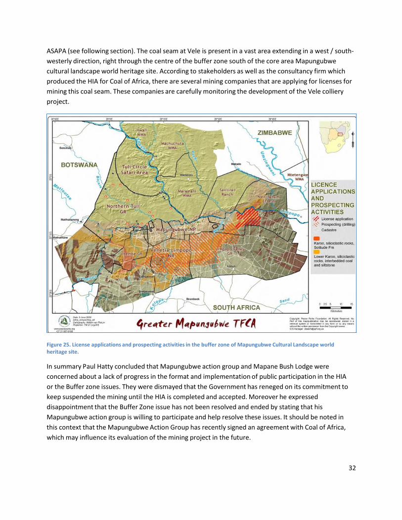
ASAPA (see following section). The coal seam at Vele is present in a vast area extending in a west / south‐
westerly direction, right through the centre of the buffer zone south of the core area Mapungubwe
cultural landscape world heritage site. According to stakeholders as well as the consultancy firm which
produced the HIA for Coal of Africa, there are several mining companies that are applying for licenses for
mining this coal seam. These companies are carefully monitoring the development of the Vele colliery
project.
Figure 25. License applications and prospecting activities in the buffer zone of Mapungubwe Cultural Landscape world heritage site.
In summary Paul Hatty concluded that Mapungubwe action group and Mapane Bush Lodge were
concerned about a lack of progress in the format and implementation of public participation in the HIA
or the Buffer zone issues. They were dismayed that the Government has reneged on its commitment to
keep suspended the mining until the HIA is completed and accepted. Moreover he expressed
disappointment that the Buffer Zone issue has not been resolved and ended by stating that his
Mapungubwe action group is willing to participate and help resolve these issues. It should be noted in
this context that the Mapungubwe Action Group has recently signed an agreement with Coal of Africa,
which may influence its evaluation of the mining project in the future.
33
Association of Southern African Professional Archaeologists (ASAPA)
The second NGO to present its case in this section of the stakeholder meetings was a representative of
the Association of Southern African Professional Archaeologists (ASAPA). The representative re‐
capitulated the concerns and criticisms which ASAPA has voiced previously in the process and briefly
described the events which led to the decision of ASAPA to strike a deal with Coal of Africa in the form of
a memorandum of understanding. In this memorandum ASAPA and Coal of Africa agrees to cooperate in
order to protect the cultural heritage of the Mapungubwe Cultural Landscape.
The representative focused the rest of the presentation on the comments of ASAPA on the HIA. At the
time of the meeting ASAPA had only had the opportunity to comment on a few appendices of the HIA,
which the organisation had managed to obtain in an unofficial manner.
The main points of concern for ASAPA are the following:
1) ASAPA was concerned by the lack of specificity when discussing changes to the buffer zone.
2) ASAPA felt that the status and role of SAHRA as compliance agency was not made clear.
3) ASAPA felt that the document did not fully address the impact of mining on the sense of place
and authenticity.
4) ASAPA reasserted that accredited Principle Investigators should conduct assessments,
specifically regarding Stone Age sites.
5) ASAPA again raised the need for a cumulative impact assessment.
6) ASAPA also pointed out the need to have thorough management plans, which obviously should
include monitoring.
In addition, ASAPA raise the following concerns about the mining plans of Coal of Africa:
7) Having Vele mine so close to the Mapungubwe Cultural Landscape World Heritage site is
definitely not ideal.
8) Mining in the vicinity of the so “declared” buffer zone is not acceptable.
9) ASAPA does not agree with a contraction of the buffer.
10) ASAPA notes with concern that more than 20 prospecting licenses as well as gas exploration
permissions have been granted in the declared Mapungubwe Cultural Landscape buffer zone.
As a way forward, ASAPA expressed its support for the recommendation in the HIA to extend the buffer
on the Eastern side of the core area of the property, right up to the Vele boundary. ASAPA also called for
transparency and thorough consultation in decision making processes regarding the World Heritage
area. In addition, ASAPA voiced its strong opinion that the rehabilitation of the mining impact on the
Mapungubwe Cultural Landscape by CoAL should exclusively be guided by the OUV’s.
After having received the full HIA document at the time of the reactive monitoring mission meeting,
ASAPA supplemented these comments in a letter to ICOMOS and UNESCO (through representatives Dag
Avango and Lazare Eloundou Assomo). This document elaborates on some of the above mentioned
points, but also adds new ones. These comments are included in the appendix of this report.

34
2.3.3. Comments on the HIA by the ICOMOS and UNESCO reactive monitoring mission
Background
The HIA was carried out by Siya Thembana Trading Ltd in November 2011 for Coal of Africa for
their submission to the South African Department of Environmental Affairs. The report was
submitted to World Heritage Centre in November 2011.
The Terms of References include the need to follow ICOMOS Guidance on Cultural Heritage
Impact Assessments for World Heritage Properties in order to identify the potential impact of
the proposed Vele coal mining proposals on the attributes of OUV within the context of a
Statement of OUV that has been agreed by the World Heritage Committee.
The general impression of the mission team is that the HIA is of a good standard and has been
carried out in a professional manner. The text and illustrations are clear and the authors are to
be commended for their professionalism.
However, the following comments stand out after a careful review of the HIA.
Structure of the HIA
The study is based on desktop research, field visits and interviews with relevant stakeholders. The HIA
states that it has taken account of the ICOMOS Guidance on HIAs, as well as on other local
guidance.
The HIA considers not just the potential impact of the proposed coal mining on OUV, it also
considers other issues that are not strictly related to the core purpose of the HIA such as mining
activities in the wider setting of the property, (including in neighbouring countries) and other
threats to the property (intensive agricultural, game, and infrastructure projects) and also
stakeholder involvement and the buffer zone. These sections are interesting and helpful in
considering the overall management of the property and do to an extent help in understanding
the context of the national debate on mining.
Finally the HIA sets out conclusions on the potential impact of the Coal Mining and puts forward
recommendations to mitigate the impact of mining and to address other identified negative
factors.
General comments on the HIA
Although the HIA mentions that the ICOMOS Guidance on Heritage Impact Assessment has been
taken into account, the methodology that this Guidance sets out has not been fully followed.

35
The Statement of OUV (see Annex 1 in the appendix) that has been agreed by the World
Heritage Committee is not set out in the HIA – merely the justification for the criteria agreed by
the Committee at the time of inscription. This is unfortunate as this means that there has not
been an attempt to identify and list the attributes that convey OUV, then to consider how the
area of the Vele Colliery relates to those attributes and thus then to consider how coal mining
might impact on those attributes. Instead impact has been considered on discrete
archaeological sites within the Vele area on one hand and on the core area of the World
Heritage site on the other.
The cultural heritage at Vele is the result of the same historical processes as in the core area of
the World Heritage site of Mapungubwe. Therefore it is necessary to set out which attributes
(archaeological sites and landscape features such as the river) carry and convey the OUV within
the property. When having defined how these attributes carry the OUV, it should also be
possible to assess how the archaeological sites and landscape features within the mining area
are associated to those attributes and support them. Once this knowledge is established, it is
possible to determine how to mitigate and monitor in order to minimize the impact on the OUV.
It is the conviction of the mission that these elements need to be clearly set out.
A related weakness of the HIA is that it lacks a holistic approach. The HIA includes useful data on
the scope of Iron Age settlements along the Limpopo river basin in Figure 4, and settlements in
Figure 6. It also sets out clearly in Figure 11 the wider context for Mapungubwe within the
various states that developed around and near the Limpopo and Shashe rivers. From these the
influence of the flood plains of these rivers is clear – and this is emphasised on page 17 of the
text where it is indicated that the alluvial plains allowed agriculture to support comparatively
large populations.
Mapungubwe needs to be considered in this wider context of the way Iron Age people utilized
and developed their societies by using the river basin and the interface between Mapungubwe
and other kingdoms such as Khami, Great Zimbabwe and Tulamela. It is clear that Mapungubwe
did not exist in isolation but was a fundamental part of a wider area within which states
developed on the basis of agriculture made possible by river floods, the exploitation of the
hinterland for gold and ivory and trade. Furthermore as is shown in Figure 11 in the HIA the
extent of influence of the Mapungubwe kingdom extended beyond the boundaries of the
property. The data shows clearly that the area of the Vele colliery was a part of Mapungubwe at
the height of its powers. The attributes that convey these link need to be identified and
protected.
The Mission considers that the Vele area needs to be considered in this wider context. Currently
the HIA sets out a list of Iron Age sites within the colliery area but does not relate these to the
36
wider landscape context. Mapungubwe was inscribed as a cultural landscape for the way the
extensive archaeological remains and rock art can be read in spatial terms. Looking beyond its
boundaries of the core area and it is clear that there is a continuum with the wider Limpopo
river basin that needs to be considered.
What is missing from the HIA is an understanding of the way the landscape of the Vele area
relates to the wider river basin and to the inscribed property. Although the authors of the
report stress that individual archaeological remains in Mapungubwe Cultural Landscape should
be valued as elements in the larger historical cultural landscape of the property, the section of
the HIA that considers value and significance only deals with the significance of individual sites
rather than the value of the ensembles of sites or the value of the cultural landscape.
Impacts not addressed in the HIA
The mission team identifies a lack of specificity on number of issues pertaining to the impact of
mining on Mapungubwe Cultural Landscape OUV.
The assessment of the impact of the mine in the landscape (4.5.1 pg 42) could have done more
to take into consideration the impact of dust and chemical products on the natural environment
in and around the Cultural Landscape. It does consider dust as a possible factor of high negative
impact on the sites but doesn’t offer any mitigation measures for it. Table 1 page 50 does not
specify on which attributes of the Cultural Landscape the impact is assessed.
Another issue on which the HIA could have been more specific concerns impacts of
underground mining. Table 1 pg.52 considers vibration as a possible factor of high negative
impact but doesn’t offer any mitigation measures for it. Attributes that will be affected by
underground mining are not specified either. The mission team asks for clarification on this
point.
The report describes indirect impacts, but there is no clear specification on what is considered
an indirect impact and on which attributes this indirect impact can be observed and how it can
be mitigated. The mission team asks for clarification on this point.
Comments on the outcomes of the HIA
The lack of a holistic approach and a proper understanding of the concepts of OUV and
attributes come out in a disturbing manner in the conclusion of the HIA, stating that:
“The mining activities of Coal of Africa Limited do impact on the elements of the Mapungubwe
cultural landscape and its OUV. These impacts are indirect in that these mining activities, which
are taking place outside the core and buffer zone of world heritage property, will only affect sites
37
of the same cultural period as those found in the core area of the MCLWHS. However, these
impacts are minimal and can be mitigated to safeguard the OUV of the MCLWHS.”
This contains contradictions regarding the impact assessment of the mining activity of Vele
Colliery. On the one hand it is stated that the mining does indeed impact on the property and its
OUV, while one the other hand it states that as the mining is not in the property or its buffer
zone, the impact is minimal.
In addition and based on the 2003 ICOMOS evaluation report, the mission questions the
statement made above. The mission considers Vele to be located within the borders of the
buffer zone that was defined at the time of inscription on the World Heritage List in March
2003.
As the HIA considered only specific sites within the Vele area as being of significance, the
mitigation measures that are being suggested deal only with specific sites and not the larger
landscape context of which they form a part.
At the site of the planned open cast mining area at Vele, the report expects that a number of
archaeological sites will be threatened by the mining activities and recommends, as a mitigation
measure, that these sites be protected by fencing or flagging, or be recorded in advance of
destruction. In the Mission’s view this is not mitigation.
The Mission understands that the consultant team which produced the HIA has struggled to find
a way to achieve some level of protection for cultural heritage, while at the same time finding
ways to make mining development in the Limpopo region possible (as amply stated by HIA team
leader Prof. Innocent Pikirayi during the visit at Vele Colliery on January 18). From the mission
team point of view however, the report push this agenda too far, as exemplified by the
following passage on page 43:
” … mining, if done within a compliance framework represents an opportunity to document some
of the World Heritage’s OUV. Mines have resources which make it possible to sustain and
manage sites…. “.
The mission agrees that any form of exploitation can result in the discovery of archaeological
sites by accident, which may contribute to generate new knowledge. However, large scale open
cast mining should not be presented as a fruitful way to preserve OUV of World Heritage Sites
or to gain knowledge about the past. Such statements may diminish the legitimacy of the HIA
and call its objectivity in to question.
Overall the HIA does not offer reassurance that the impacts of the opencast mining can be
mitigated.
38
For the underground mining areas the HIA suggests that cultural heritage sites could be
protected from vibration impacts, if this underground mining takes place at a sufficient depth.
Since coal mining must always take place at the depth where the coal seam is situated, the HIA
should have presented information about the depth of the planned underground mine, as well
as the properties of the rock between the coal seam and the surface and thereby the stability /
fragility of the ground and the possible risks for cave‐ins after the coal seam have been
removed. The report should also have discussed which mining methods Coal of Africa will use, in
particular how the company will secure the roof of the mine. This information is available in the
EIA, where the company states that they will use board and pillar methodology and that they
intend to leave pillars in order to secure the roof. In addition, during the reactive monitoring
mission visit to the Vele Colliery on January 18, the mission team was able to acquire this
information straight from representatives of Coal of Africa. The HIA should have contained more
exact information on these issues in order to ascertain potential impacts and mitigation
measures
Another point of critique is the fact that the HIA fails to provide a 3‐5 years long monitoring
programme as required by the Terms of Reference, in answer to the recommendations
submitted by the monitoring mission report 2010 in the framework of the decision 34 COM
7B.52.
2.3.4 Buffer Zone
On the matter of the buffer zone, the mission team would like to draw attention to the fact that
the HIA report states that the World Heritage Committee in its 2010 SOC Report did not
acknowledge that a Buffer Zone had been approved by the State Party in 2009. This is because
the Buffer Zone has never been presented to the World Heritage Committee for approval in
terms of whether it is adequate to protect the property. This point is noted in the Retrospective
Statement of OUV under Protection and Management Requirements. It is therefore imperative
that the State Party submits before the 36th Session of the World Heritage Committee, the
official buffer zone, in order to comply with the request of the World Heritage Committee
(Minor Modification Boundaries). The mission recommends that the 2009 adopted buffer zone
should be increased to incorporate the land east of the core area that was described as buffer
zone at the time of inscription in 2003. As a first step, the 7 km stretch east of the core area up
the border of Vele should be incorporated. Likewise, the mission emphasizes that any reduction
of the buffer zone is totally unacceptable.
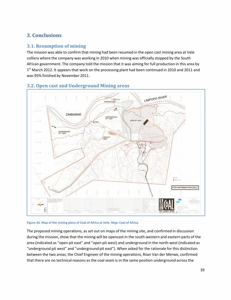
39
3. Conclusions
3.1. Resumption of mining The mission was able to confirm that mining had been resumed in the open cast mining area at Vele
colliery where the company was working in 2010 when mining was officially stopped by the South
African government. The company told the mission that it was aiming for full production in this area by
1st March 2012. It appears that work on the processing plant had been continued in 2010 and 2011 and
was 95% finished by November 2011.
3.2. Open cast and Underground Mining areas
Figure 26. Map of the mining plans of Coal of Africa at Vele. Map: Coal of Africa.
The proposed mining operations, as set out on maps of the mining site, and confirmed in discussion
during the mission, show that the mining will be opencast in the south‐western and eastern parts of the
area (indicated as “open pit east” and “open pit west) and underground in the north‐west (indicated as
“underground pit west” and “underground pit east”). When asked for the rationale for this distinction
between the two areas, the Chief Engineer of the mining operations, Riian Van der Merwe, confirmed
that there are no technical reasons as the coal seam is in the same position underground across the
40
whole area. The reason why Coal of Africa are choosing to mine underground near the Limpopo River in
the north‐west is to protect the large commercial citrus farms in that area, which would be destroyed by
open cast mining. As they see no economic interest in what they called the ‘dry bush land’ over the rest
of the site, they are choosing to undertake opencast mining in those areas. It is thus apparent that Coal of
Africa could certainly mine underground across the entire site. They are not planning to do so as it is
more profitable to mine open cast. However this approach does not confirm the stated aim of the
company to protect the landscape.
3.3. Impact of the mining of the OUV of the property The HIA undertaken by the State Party considered the potential impact of the mining, both opencast and
underground, on the World Heritage site. Although this was a detailed study, it had not been
underpinned by the Statement of OUV agreed by the World Heritage Committee, and thus had not
considered a detailed list of attributes that convey OUV. As a result, the HIA had focused on specific
archaeological sites within the mining site without a clear understanding of how they relate to each
other in landscape terms or how they relate to the inscribed cultural landscape area. The conclusion
drawn by the HIA was that any sites within the opencast mining areas could be destroyed once they had
been recorded and that in this way, or fenced off within the area of the processing plant, knowledge of
them could be recorded. The mission considered that protecting individual sites or undertaking rescue
archaeology on individual sites in advance of open cast mining did not equate to the mining operations
having ‘minimal impact’ as set out in the HIA. Once the open cast mining had finished in a particular area,
any archaeological sites, or graves of ancestors would have been destroyed, and the re‐filled areas would
be ‘coal mining ‘ landscapes and not cultural landscapes associated to the sites of the K2 and
Mapungubwe period cultural landscapes in the inscribed property, or landscapes of value to the local
communities.
As well as the major devastation to the landscape that the opencast mining would bring, there are other
impacts from the processing plant, an air strip and access roads to the western open cast mining areas.
The mission noted other interventions within the landscape, such as a circular clearing, but its purpose
was not clarified. Of these the road and the trucks using it which could be as high as one every 1.75
minutes once the mine is in full production, would cause the greatest threat to the sense of place of the
area.
There is also reason for concern in terms of the water requirements for open‐cast mining in an area that
already has water shortages.
By contrast with the opencast mining areas, the underground mining areas could interfere far less with
the landscape and be mitigated if appropriate processes were put in place to reduce vibration, for the
necessary ventilation and escape routes, and to support the roof.
The major threat to the setting of the inscribed property is thus the open cast mining process. In the
view of the mission this would be unacceptable in terms of its impact on the landscape setting of the
inscribed property and for the way it would jeopardise the cultural continuum between the landscape

41
within the property and that in its setting. Furthermore given the extent of the coal seam under the
buffer zone, there is potential for huge swathes of land around the property to be irreversibly damaged
in a similar way.
3.4. Possible Mitigation Measures It is the view of the mission that no mitigation measures are possible to reduce the impact of the open
cast mining. It does not accept the view put forward in the HIA that recording archaeological sites in
advance of destruction can be said to safeguard the landscape.
In order to mitigate the overall impact of mining, the mission considers it essential for all mining to be
underground, with appropriate safeguards related to structural stability and vibrations.
In relation to underground mining, detailed arrangements for the extraction of water from the Limpopo
River and for the provision of electricity would need to be agreed to mitigate the impact of the necessary
infrastructure. There will also be a need to mitigate the impacts of the large number of coal trucks
travelling to Musina, the transport hub.
Any underground coal mine will also need escape routes in case of accidents as well as ventilation
openings in order to get rid of gas and coal dust. There will need to be stiff rules on how escape‐ and
ventilation openings could be designed in order to mitigate impacts on the landscape.
Furthermore in order to put in place appropriate mitigation measures related to the impact of roads,
plants and vibration from underground mining, and to facilitate future monitoring, it will be necessary
for more detailed surveys to be undertaken on the overall Iron Age landscape features, and of sacred
features associated with local communities.
3.5. Relationship with local communities & NGOs The mission noted that leaders of local communities felt excluded from consultations over the mining
approvals, that their concerns had not been acknowledged and that they have not had any chance to
influence the process. Indeed overall they considered that they had not been consulted. NGOs
considered that they had not involved in the processes in a formal and open manner, nor been provided
with adequate information.
3.6. Protection of the setting of the property and the effectiveness of the buffer
zone The HIA recommended that the Buffer Zone be reduced in size. The Mission did not agree with these
proposals and indeed consider that the buffer zone (as gazetted in 2009) needs to be increased to
encompass the area to the east of the property which was indicated as buffer zone at the time of
inscription in 2003. A first step must be to include the area between the eastern border of the
Mapungubwe cultural landscape core area and the western border of the Vele mining area. The Buffer
Zone also needs to be approved by the World Heritage Committee in terms of its delineation and the
protection it offers. In terms of the latter, clear policies related to mining need to be set out.

42
3.7. Further threats from mining activities in the Buffer Zone The mission is concerned that the HIA has revealed a large number of applications for prospecting rights
in the current Buffer Zone, some of which have been approved. Around twenty of these relate to the
coal seam that runs south‐west from the Vele area under the Buffer Zone. Future coal mining areas have
been delineated and farms purchased by Coal Mining companies. It was reported to the Mission that
several companies are carefully monitoring the development of the Vele colliery project. This reinforces
the need for clear protection policies within the Buffer Zone which prohibit mining both open cast and
underground.
3.8. Mining infrastructures within the property The Mission was made aware of several large installations in the northern part of the property that are
related to the de Beers Venetia diamond mine on the south of the property. These installations provide
the mine with water from the Limpopo River. These have a substantial adverse visual impact.
3.9. State of Conservation of the property; K2 site and water extraction plants The mission noted that whereas the Shroda site and Mapungubwe Hill appear to be in a reasonable state
of conservation, the K2 archaeological site is seriously deteriorated putting at risk the major source of
archaeological evidence for the time when the centralised state emerged.
4. Recommendations
4.1. As it is the view of the mission that no satisfactory mitigation measures are possible to
reduce the impact of the opencast mining on the property’s OUV, it does not share the view put
forward in the HIA that recording archaeological sites in advance of destruction can be said to
safeguard the landscape.
4.2. Taking into account the assurances given to the mission that there are no technical reasons
why Coal of Africa could not mine underground across the entire Vele Colliery site, instead of
only near the Limpopo River as currently proposed to protect the citrus farms, the mission
considers that there is an alternative to opencast coal mining. If opencast mining is pursued, it
would irreversibly damage the setting of the property in terms of the way it supports the
cultural landscape of Mapungubwe. Therefore the mission recommends that opencast mining
operation should be reconsidered at Vele Colliery after the current existing footprint is mined
out. Thereafter, as an exceptional measure, future mining operations in the vicinity of the buffer
zone should be carried out underground.
4.3. Underground mining may pose greater risks to employees working underground, which
naturally mean that proper safety measures must be put in place to protect their safety, such as
proper pillars, ventilation systems and escape routes. When constructing those ventilation
systems and escape routes – and any other supporting infrastructure – it will be necessary to

43
first investigate, then mitigate and thereafter monitor their impacts on the cultural landscape. It
will be of crucial importance to safeguard the long‐term stability of the underground mines, not
only when they are in operation but also after they are abandoned, in order to make sure that
there are no cave‐ins and subsequent formation of cracks and depressions in the landscape.
4.4. In paragraph 11 of decision 35 COM 7B.44, the World Heritage Committee “Calls upon the
Director‐General of UNESCO, in consultation with the Chairperson of the World Heritage
Committee, in the event of the mission concluding that the heritage impact assessment indicates
that the proposed mining would not threaten irreversibly the property's Outstanding Universal
Value, to consult with the State Party, in line with the provision of Decision 35 COM 7.2,
paragraph 6, on any urgent mitigation measures and monitoring programmes that might be
requested before mining operations were to commence”. Paragraph 6 of decision 35 COM 7.2
sets the situations where exceptional initiatives can be taken by the Director‐General of
UNESCO in consultation with the Chairperson of World Heritage Committee, regarding actions
to be taken in place in between two Sessions of the World Heritage Committee.
4.5 For this specific case, the mission team advises the Director‐General of UNESCO, that it is
not possible to recommend satisfactory mitigation measures that could be put in place to
ensure that the current authorized mining proposals do not impact adversely on OUV.
The mission further advises that the Director‐General, after consultation with the Chairperson
of the World Heritage Committee, writes a letter to the State Party to inform them of the
outcomes of the mission and that the mission recommendations related to the reconsideration
of the mining processes will be put before the World Heritage Committee for its decision.
4.6. In order to allow the establishment of a detailed monitoring programme, the HIA needs to
be augmented through a detailed site survey of the overall mining area. This survey should be
undertaken by professional archaeologists who are clearly independent of Coal of Africa, and in
cooperation with community representatives.
4.7. The Buffer Zone needs to be extended to the east of the property and the revised Buffer
Zone, with details of protective policies, should be submitted to the World Heritage Committee
for approval
4.8. The revision of the Management Plan should be used as an opportunity to involve fully
community representatives in the management of the property through the establishment of a
Mapungubwe Management Committee.

44
5. Detailed Recommendations
5.1. Secure the buffer zone
Figure 27. The proposed buffer zone (in South Africa and the larger TFCA) originally defined in the nomination dossier examined in 2003. This is the extent of the buffer zone still considered by the World Heritage Committee.
The definition of the buffer zone in the HIA is based on the buffer zone gazetted by the South African
government in 2009. ICOMOS and the WHC bases their interpretation of the buffer zone on the
requirements said in paragraph 104 of the Operational Guidelines. Therefore the mission team is
concerned by the recommendation of the HIA to reduce the extent of the buffer zone. It is our view that
the buffer zone needs to be expanded – not decreased. This expansion should take place in the area east
of the Mapungubwe cultural landscape core area, as already stipulated in the 2010 WHC‐ICOMOS mission
report. In other words, the mission team re‐state the importance of the concern already formulated in
paragraph 8 of decision 35 COM 7B.44:
“Express its concern that the buffer zone and the proposed greater TFCA, as was envisaged at the time of
inscription to protect the property within South Africa, have not yet been completed as a result of the
slow pace of land acquisition, thus continuing to leave the area east of the property unprotected.”
5.2. The issuing of new prospecting licences in the buffer zone of the Map.CL.
WHS The mission team is concerned that the HIA has revealed that more mining companies have applied for,
and in some cases have received prospecting rights in the buffer zone south of the core area of the
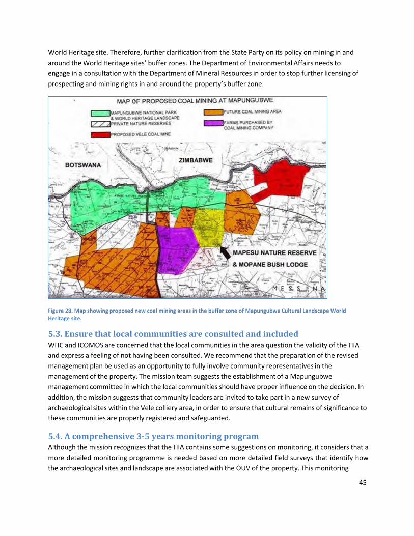
45
World Heritage site. Therefore, further clarification from the State Party on its policy on mining in and
around the World Heritage sites’ buffer zones. The Department of Environmental Affairs needs to
engage in a consultation with the Department of Mineral Resources in order to stop further licensing of
prospecting and mining rights in and around the property’s buffer zone.
Figure 28. Map showing proposed new coal mining areas in the buffer zone of Mapungubwe Cultural Landscape World Heritage site.
5.3. Ensure that local communities are consulted and included WHC and ICOMOS are concerned that the local communities in the area question the validity of the HIA
and express a feeling of not having been consulted. We recommend that the preparation of the revised
management plan be used as an opportunity to fully involve community representatives in the
management of the property. The mission team suggests the establishment of a Mapungubwe
management committee in which the local communities should have proper influence on the decision. In
addition, the mission suggests that community leaders are invited to take part in a new survey of
archaeological sites within the Vele colliery area, in order to ensure that cultural remains of significance to
these communities are properly registered and safeguarded.
5.4. A comprehensive 3‐5 years monitoring program Although the mission recognizes that the HIA contains some suggestions on monitoring, it considers that a
more detailed monitoring programme is needed based on more detailed field surveys that identify how
the archaeological sites and landscape are associated with the OUV of the property. This monitoring
46
program must include a careful monitoring of the currently on‐going open cast mining operations and –
after these operations have stopped following the recommendations of this report – a continued careful
monitoring of underground mining operations, associated infrastructures and processing plants. In
addition, the program must include careful monitoring of all rock‐art sites in the core area of the
Mapungubwe cultural landscape as well as in the buffer zone.
The mission is informed that a Memorandum of Agreement (MoA) was signed between the Department
of Environmental Affairs and Coal of Africa. This MoA could be the basis for the creation of a Foundation
for the conservation of Mapungubwe c cultural landscape World Heritage site. The Executive Director of
Coal of Africa, Mr John Wallington, has expressed its readiness to contribute to such a foundation and
also to mobilise other interested private companies such as De Beers (Venetia). The main purpose of the
Mapungubwe foundation would be to fund the implementation on the 3‐5 year monitoring programme,
as well as the activities contained in the revised management plan to be submitted by the State Party.

47
6. Appendices
6.1. Comments on Heritage Impact Assessment by the Association of Southern
African Professional Archaeologists (ASAPA) on 30 January 2012 Comments on Heritage Impact Assessment by the Association of Southern African Professional
Archaeologists (ASAPA) on 30 January 2012
1. Introduction
1.1. ASAPA recognises that the Heritage Impact Assessment submitted to UNESCO is more thorough than
previous attempts. This is encouraging. We, however, still have a few major concerns. These are
outlined below . Our comments are general and clustered according thematically. We do not provide a
detailed page by page critique, but rather engage with the broader content. In a few cases specifics are
pointed out, but this is not exhaustive.
1.2. Before proceeding to the comments, ASAPA notes with regret that in spite of requests to the state
party and CoAL , ASAPA did not receive a copy of the full revised Heritage Impact Assessment (HIA)
before the meeting with UNESCO on the 20th of January 2012 at Dongola Ranch, and thus we were not
able to provide comments on the document to the meeting. Consequently, ASAPA undertook to provide
written comments to UNESCO.
1.2.1. In spite of being alerted to the fact that ASAPA (and the Mapungubwe Action Group) had not
received copies of the HIA, and noting that ASAPA committed itself to providing written comment in the
meeting with all parties present, neither the State party, nor CoAL, supplied ASAPA with copies of the
revised HIA after the meeting. The copy of the HIA on which these comments are based was handed to
us by UNESCO representatives after the meeting at Dongola ranch.
1.3. ASAPA notes with delight that the Archaeological Impact Assessment (AIA) Report (Appendix 8)
acknowledges that the ancient Mapungubwe Cultural Landscape (MCL) is bigger than the Mapungubwe
National Park (MNP) and World Heritage Site (WHS), and that sites associated with the MCL will be
impacted on by the Vele development.
1.4. ASAPA notes that the Mapungubwe coalition was verbally informed by Prof. Van der Riet that the
starting point of this HIA was that the mine will go ahead.
1.5. As indicated by the MOU submitted to UNESCO by CoAL, ASAPA is engaged in negotiations with
CoAL Africa. The outcome of these negotiations might include applications for authorisations as well as
improvements to the EMP, mitigation measures and offsets. We also hope to ‘raise the bar’ for all
possible future mining operations in the MCL and surrounds.
1.6. In spite of this pragmatic step ASAPA remains opposed to the industrialisation of the MCL.
48
1.7. ASAPA previously commented on a draft version of the HIA that did not include any of the
Annexures. In cases where we feel our concerns have not been addressed we repeat our comments on
the draft version here.
2. General remarks
2.1. ASAPA welcomes the mapping of the various impacts, threats or potential impacts, and sees this as a
step in the right direction.
2.2. We, however, suggest that there is a disjuncture between the recommendations made in the revised
HIA and the specialist studies conducted. In particular, the AIA only assesses the impact on sites on the
Vele property, and the Historical study focuses only on people who have claimed links to medieval
Mapungubwe. They, however, do not provide a sound foundation for some of the more general
conclusions and recommendations.
2.2.1. If recommendations are to be made about the whole MCL beyond the Vele property as part of the
current process, a full study should be conducted for the whole MCL at the cost of CoAL of Africa. This
should include a cumulative impact assessment of the potential impact of all the proposed industrial and
other developments in the MCL.
2.3. We also note that the report, whilst expanded, still does not include a full assessment of living and
intangible heritage of the properties on which Vele colliery is situated.
2.4. We would have liked to see more integration of the individual specialist reports into the overall HIA.
3. Impact on Sense of Place and Outstanding Universal Values (OUVs)
3.1 The definition of “sense of place” used is certainly valid. It should also be noted that at least one
component of the sense of place in the vicinity of Mapungubwe does in fact relate to the natural values
and the tranquillity of the area as it is these factors that are likely to attract eco‐tourists and thus help
sustain the MCL WHS as a destination within South Africa. At the moment, it is possible that there may
soon be far more than one mine in the area – how is this sense of place likely to be affected by the large‐
scale industrialisation of the area?
3.2. It is a mistake to consider Mapungubwe’s sense of place as a present‐day phenomenon. Among other
things, Mapungubwe is a WHS because the physical landscape is still relatively unaltered. Mapungubwe is
not unique because of how local people feel about it now, but because of what happened there in the
archaeological past. We know from research that Zhizo/ K2/ Mapungubwe communities utilised the
physical landscape for agriculture and field camps, grazing and cattle posts, ritual and residences. All these
sites contribute to the landscape and sense of place. While the MNP and present buffer zone contain
evidence for much of this activity, the MNP only incorporates one half of the main agricultural system (i.e.
vlei cultivation).
3.3. Downstream floodplains lie outside the MNP in the area of the Vele mine. Much of the evidence for
this activity has been damaged by commercial agriculture. This is why the mine area is important.

49
3.4. For these reasons, a new mine that alters the physical environment of the 10th ‐14th centuries
landscape is a concern.
3.5. In this regard, coal mining is more of a problem than diamond mining. With diamonds, the product
can be taken out in a suitcase, while coal has to be transported in trucks, conveyer belt or by rail.
Moreover, cumulative disturbances can make matters worse. Other mines are quite likely to follow Vele
colliery, particularly if the buffer zone is contracted.
3.6. It is thus premature to claim that the new mine will not affect the MCL; the ancient landscape was
bigger than the present MNP.
3.7. We also disagree with the interpretation of the nomination that only the period AD 900 to 1300 is of
concern in the nomination. Instead the nomination throughout referred to the cultural landscape as a
whole, and repeatedly returned to the complexity of the occupation sequence.
3.8. We also are astounded that this it is implied (illustrated for example in Figure 11) – in the face of
substantial archaeological research in the area that demonstrate the opposite e.g. Van Doornum 2005,
2008, 2009 – that the stone age material and rock art does not date to the period AD 900 to AD 1300. It
has been conclusively demonstrated that the farmers did not displace MCL hunter‐gatherers in AD 900,
and that they coexisted in the MCL for a substantial period of time.
3.9. Furthermore, threats to other resources such as rock art, Stone Age and Late Farming Community
(Iron Age) sites, and the natural environment, may undermine the authenticity of the cultural landscape,
the sense of place, and the interaction of human values within which the Mapungubwe sites developed
and should therefore also be identified and managed.
3.10. ASAPA is perplexed by the claim on page 13 that the current threats are the same as at the time of
nomination. At the time of nomination there was not a colliery on the doorstep of the MCL WHS, nor had
prospecting licenses been granted to more than 20 companies in the MCL buffer zone, nor was gas
exploration permitted.
4. Buffer Zone
4.1. We strongly agree with the risk assessment vis‐a‐vis the lack of clarity regarding the buffer zone
between the MCL WHS core area and the proposed Vele mine, and the need to have these issues
clarified as soon as possible. The buffer in this area is at best murky.
4.2. ASAPA, however, asserts that the rest of the buffer zone is well defined. It was first gazetted for
comment on 18 December 2007 in the Government Gazette No 1200. The subsequent gazetted
declaration ‐ World Heritage Convention Act, 1999 (act no. 49 of 1999), as Gazetted in the Government
Gazette no. 31832 (71) ‐ brought the MCL WHS into being in terms of South African legislation on the
30th of January 2009.
4.3. ASAPA strongly asserts that any attempts to redefine the buffer zone cannot involve the shrinkage of
the existing buffer.

50
4.4. We suggest that instead of contracting the buffer it should be expanded in the eastern area between
the MCL WHS core and Vele mine, where there is no gazetted buffer in terms of South African legislation.
4.5. On page 8 of the revised HIA it is stated that: “There is no consensus regarding the meaning,
purpose, nature and in some cases extent of the buffer zone of the MCL WHS. Various institutions, I&APs
and other stakeholders have different ... Conceptualisations of what constitutes such a buffer zone
(Refer to Annexure 7).”
4.5.1. ASAPA contends that the current different “conceptions by stakeholders” is insufficient reason to
shrink the buffer zone declared in terms of South African legislation.
4.5.2. Also, we note that enactment of the declaration in terms of South African law was done in terms of
the World Heritage Convention Act. This means that the intention of the declaration by Minister Van
Schalkwyk was clearly based on the internationally accepted World Heritage Committee definition of the
buffer zones, and the protection this implies. This conclusion is further supported by the inclusion of
WHSs as protected areas in terms of the Protected Areas Act.
4.6. ASAPA welcomes the recommendation on page 8 that no mining should take place in the buffer
zone.
5. Community consultation
5.1. Based on the input from an ASAPA member with extensive experience in working with communities
in the context of mining, ASAPA asserts that the views expressed in the HIA regarding communities and
mining is certainly not the norm. South African communities frequently have seen very little economic
improvement from mining.
5.2. ASAPA finds it extremely problematic that the authors have decided on behalf of the community/ ies
that the mine will be to their benefit.
5.3. Our advisor found it problematic that the authors of the report accepted it as a given that mining is
to the benefit of local communities. In fact, in several cases the standards of living of local communities
have been negatively affected, and in many other mining areas local water sources have been severely
impacted on and new schools and clinics stand empty.
5.4. We are also perturbed by the assumption that the tribal authorities enter into agreements that
always benefit their communities. Studies on communities displaced by mines have overwhelmingly
shown that this is not the case. But it is not immediately clear whether anyone will be directly impacted
by the mine. Again, the study should reflect on this.
5.5. The report also fails to consider the very unequal power relations that exist between the mine and
the communities. Who will stand as arbiter on behalf of the communities to ensure that social
responsibilities are met?
51
5.6. Lastly, the authors fail to reflect on repeated examples of community break down caused by ill‐
considered deals that do not include all community members. Communities need to be included in
decision making processes so that they can make informed decisions.
5.7. ASAPA also queries what steps will be put in place to monitor and ensure the successful community
development. What firm commitments are in place?
5.8. ASAPA is convinced that this HIA needed to reflect on whether the communities have been fully
informed of their options; their rights to their heritage; the impact and implications of mining on their
well‐being; and that these communities were able to make a considered decision about their own future
AND that mechanisms are in place to enable them to participate in decision‐making.
6. Unauthorised damage to site
6.1. ASAPA notes with very deep concern that the revised HIA indicates that Sites 12, 13, 18 and 34 are
already being impacted on. As far as ASAPA is aware these impacts have not been permitted by SAHRA,
and thus are illegal. This does not bode well for compliance with legislation in future.
6.2. We again draw CoAL Africa’s attention to Section 35 (4) of the National Heritage Resources Act
(NHRA), no 25 of 1999. In terms of which “No person may, without a permit issued by the responsible
heritage resources authority—(a) destroy, damage, excavate, alter, deface or otherwise disturb any
archaeological or paleontological site or any meteorite; (b) destroy, damage, excavate, remove from its
original position, collect or own any archaeological or paleontological material or object or any
meteorite;….(d) bring onto or use at an archaeological or paleontological site any excavation equipment
or any equipment which assist in the detection or recovery of metals or archaeological and
paleontological material or objects, or use such equipment for the recovery of meteorites”.
7. Stakeholder engagement
7.1. We reiterate the point made on the draft revised HIA that South African legislation requires that
detailed proof of stakeholder consultation be provided.
7.1.1. For example, it is noted that on page 34 and 35 of the HIA that interviews were carried out with a
range of persons. Detailed information on the date, place, individuals and content should be provided.
On page 29 it is stated that the Universities of Cape Town and Pretoria were consulted. Does this refer to
informal conversations with the consultants who are from those institutions, or were formal open
meetings held at those institutions? If meetings were held, the date of the meeting, a list of attendees
and a summary of the discussions should be provided.
7.2. It is noted that during the stakeholder engagement process (Annexure 7, p. 4) a series of questions
were put to members of local communities. There does not seem to be any full report on the answers to
these, particularly to those questions relating to the existence of intangible heritage.
7.3. Extensive reference is made in the revised HIA (e.g. page 29) of very wide consultation with NGOs,
Action Groups and Trade Unions. This is not reflected in the detailed schedule and we strongly advised
that the two documents should be aligned.
52
7.4. ASAPA also notes that the HIA report and Annexures are not very specific on the nature of contact
with the stakeholders, in particular a very short table of specific consultation is provided on page 13 to
15. This includes very few registered Interested and Affected Parties (I & APs).
7.4.1. Consequently, we request that the report reflects (possibly in tabulated format) how many of the
365 registered I&APS (as reflected in the Vele EMP) were consulted, and the date and nature of such
consultation.
7.4.2. If the registered I&APs were not consulted the report should explain why they were not consulted.
ASAPA raises this matter because several registered I&APs have indicated that they have not been
consulted regarding the HIA. These might, however, be minor omissions rather than trends, but this is
impossible to assess in the absence of detailed information.
7.4.3. In particular, ASAPA requests that the report reflects on the nature and extent of consultation on
this HIA with the Endangered Wildlife Trust, BirdLife South Africa, Wilderness Foundation South Africa,
Peace Parks Foundation, World Wide Fund for Nature South Africa and Mapungubwe Action Group, with
which CoAL has signed a memorandum of understanding. Consultation with these parties is particularly
relevant because these parties have contested the environmental baseline data, such as biodiversity and
dust, on which this report is based. This is not reflected in the report.
7.5. Furthermore, ASAPA feels that the revised HIA does not make it explicit if the stakeholders
consulted in the drafting of the HIA were registered I&APs. The current format of Annexure 12 makes it
difficult to assess this (see suggestion below). If stakeholders were consulted who are not registered
I&APs a separate list indicating their details should be attached.
7.6. On a related matter ASAPA suggests that instead of listing only names and contact details for
stakeholders in Annexure 12, the list should also reflect affiliation (see the format used in Annexure N1
of the Vele EMP). We feel that it is important to reflect on the affiliation of I&APs, because the current
format makes this data very difficult to evaluate the extent of participation.
7.7. Annexure 7, page 13 lists SAHRA as a professional body. Obviously, this is incorrect. This resonates
with the concern that ASAPA raised i.t.o. the draft revised HIA that the legal decision‐making status of
SAHRA is still not fully recognized. SAHRA is an "organ of State" tasked with the protection of national
heritage resources in terms of the NHRA. We feel it is crucial to recognise that:
7.7.1. SAHRA was established in terms of the NHRA 4 d) “ ... to manage the national estate and makes
provision for the establishment of provincial heritage resources authorities to manage provincial and
local heritage resources.”
7.7.2. Furthermore, SAHRA is to co‐ordinate the identification and management of the national estate,
as set out in NHRA S13 (b) SAHRA is to “co‐ordinate the management of the national estate by all
agencies of the State and other bodies and monitor their activities to ensure that they comply with
national principles, standards and policy for heritage resources management; (c) identify, record and
manage nationally significant heritage resources and keep permanent records of such work;”

53
8. Missing / insufficient data / studies
8.1. The brief of this team included to “Compile an HIA report that has the following components: I.
Archaeology – Stone Age, Iron Age, Rock Art; II. Palaeontology; III. History or Contemporary History
(some as represented by historical graves and settlements) and IV. Living heritage and intangible
heritage”.
8.2. We reiterate our concern raised regarding the original EIA, and we contend that this report does not
seem to address the latter two components, History or Contemporary History and Living heritage and
Intangible Heritage. Since these are also integral to any understanding of the Outstanding Universal Value
of the site, we are not sure why they are not discussed in full. This assessment of the intangible
values should in addition to the focus on the descendant communities examine the values of the MCL for
the nation as a whole.
8.3. The historical study only aims to “provide insight into the history of various communities that occupy
the area (northern and eastern parts) of Mapungubwe. The report largely draws from a literature review
also shared history of occupation, migration and cultural practices”, rather than specific interviews with
people living in the area, or who have lived in the area in the past.
8.4. Our concern raised during the original EIA, and draft of this document still stands and that is that this
team surprisingly did not include a Stone Age specialist. This unfortunately means that there is still a gap
that this new revised HIA should address.
8.5. Irrespective of the value placed on sites from different periods in the nomination document, a
thorough HIA as required by SAHRA and NEMA should contain a full assessment of these aspects, by
specialists in these fields. As communicated to all ASAPA members in August 2009, SAHRA informed
members of the ASAPA executive that they would like to see heritage impact assessments carried out by
multi‐skilled teams with the appropriate credentials. In addition, this has been one of the major critiques
and shortfalls of the original HIA. If this subsequent HIA is supposed to address these deficiencies it is not
clear why this approach has not been enacted.
8.6. Names of consultants who undertook the surveys / interviews must be included. Where relevant,
such as in terms of the survey, their ASAPA CRM accreditation levels should be reflected.
8.7. Please note that it is ASAPA's understanding that any stand‐alone HIA has to be circulated for public
comment.
8.8. The Paleontological assessment that is referred to was done at a desktop level, we are not familiar
with the recommendations and results in the paleontological report but would have thought that a field
study was necessary as part of the HIA.
54
9. Comments on the study Historiography and Traditional dispensation of Mapungubwe: Vele
Colliery and surrounding communities.
9.1. ASAPA sent the historiography report to an academic historian for comment. He advised that this
report is weak and in need of major revision.
9.2. Noting that this is a specialist report, we suggest that it should be sent for peer review by historians
and social anthropologists. These comments could help to improve the report.
9.3. Noting that we are not specialists in this field, ASAPA is not in the position to provide substantial
comments, but we note that:
9.3.1. The authors fail to reflect on the history of power imbalances in the area, and on the history of
displacement brought about by National Parks/the army, etc. These factors will impact on the
communities' ability to discern between sound business proposition and vacuous promises.
9.3.2. An area of concern is the exclusion of the historical developments since medieval Mapungubwe,
which might be of great concern to the communities in the region, or those displaced by Apartheid
government actions / policies in the 1900s, as it directly relates to their histories in the area.
9.4. This specialist study omits key data sources including:
9.4.1. The comprehensive study conducted by Profs Caruthers and Bonner for the WHS nomination
process.
9.4.2. Oral histories recorded in the documents related to the numerous restitution land claims and land
claims decisions in the area.
9.4.3. Published ethnographic and oral accounts collected in the 1930s by members of the Mapungubwe
research team.
10. Documents consulted
10.1. We again indicate that the list of references only lists the ASAPA appeal to the Mining Right. There
is a host of additional information that is contained in subsequent legal documents – the EMP appeals,
the various replies as well as the interdict application and the replicating affidavits from each side.
Perhaps these should also have been consulted.
11. Technical comments
11.1. Page 8. point 6 states that “The broader MCL extends to the neighbouring countries i.e. Botswana,
Zimbabwe and some areas in South Africa outside the gazetted National Park. Mining activities are either
taking place or have been licensed in all these areas and these activities may pose a threat both directly
and indirectly to the individual elements of the cultural landscape. Whilst the State Party is making
tremendous efforts to regularize such activities, however, with full compliance to local legislation and
effective monitoring, the impacts can be minimised.”
55
11.2. This could imply that mining may go ahead in the MCL because impact can be minimised. ASAPA
contends that mining should not be allowed in the MCL WHS buffer zone, and thus we are concerned by
the claim that impacts of mining “can be minimised”.
11.3. It is important to note that in terms of the NHRA, mitigation would include all significant
archaeological sites impacted on, irrespective of their affiliation or date. This includes Stone Age and
historical sites.
11.4. ASAPA does not agree with the conclusion that the impact on MCL sites outside the WHS on the
Vele property will be 'minimal' (HIA page 7). Sites in the east and west pits and related infrastructure will
be destroyed. Mitigation is simply a measure to rescue research potential before destruction / damage.
11.5. ASAPA is surprised that the threats to biodiversity map (Fig. 17) does not include the proposed
Mlilo coal fired power station, gas exploration or potential coal mines in the buffer zone (where more
than 20 prospecting righst have been granted.
11.6. We also are not clear what data sets were used in the assessment of the threats to biodiversity.
11.7. Our reading of Figure 20 is that the MCL is under intense threat.
11.8. On p. 23 it is said that “there are several mining claims”, it is our understanding that there are a
great deal more than “several” mining and prospecting claims in the vicinity. We would like to see some
consideration in this report of what you think the cumulative impact of numerous mines will be on the
OUV of the WHS, independent merely of the impact on individual sites.
11.9. The sites with graphite decoration most likely belong to the Khami period.
11.10. The information about sites 27 and 28, sites 29 and 30 is still missing.
11.11. Finally, ASAPA is advised that any site with features, such as grain bin foundations, middens or
kraals require mitigation.
11.12. The co‐ordinates also are of concern as they should relate to grave sites that have to be plotted
for clear identification.
11.13. What is academic research as set out in the HIA recommendations? How is this different from
contract or CRM research?
12. Key factual errors in the report
12.1. On page 12 of the revised HIA the word “later” has been inserted, but it is still implied that the rock
art study was incorporated into the initial EMP, which it was not. As is clearly indicated on the cover of Mr
Hollmann’s report it was completed in July 2010, and was in fact only conducted as an outcome of appeal
and interdict processes set in motion by the Mapungubwe Coalition.
56
12.2. The legal issue around terminology we raised in response to the first heritage report pertains. The
Roodt study was not a Heritage Impact Assessment, and definitely not a “broad‐based HIA” (HIA page
12). Rather it was essentially an AIA, as it only contained information about the archaeology.
12.3. Map 5 illustrates the distribution of rock art sites, not Stone Age sites as indicated. An earlier
version of this map was produced by SANParks with information from Mr Eastwood as part of the
nomination process. Not all of the rock art sites are linked to the Stone Age; some contain farmer art.
12.3.1. It also is worth noting the proximity of the rock art site in Zimbabwe to the Vele colliery.
12.4. Map 6 only illustrates farming community sites that date from AD 900 to AD 1300 in the region, not
the “distribution of various groups that settled in the region of the Mapungubwe cultural landscape during
various periods in history”.
12.4.1. It has been shown conclusively that hunter‐gatherers making stone tools shared the landscape
with farmers at this time. Furthermore, occupation of the area did not end in AD1300, but continued
throughout the sequence.
12.5. Map 11 in fact only reflects Zimbabwe culture type sites in the MCL. Again we point out that
hunter‐gather occupations continued into this period, and that their presence is significant i.t.o the
OUVs.
12.5.1. We also are intrigued that Figure 11 implies that the Venda state dates to the period before AD
1450. Most recognised research places the development of this state much later.
12.5.2. Furthermore, we are surprised that the presence of Sotho‐Tswana speakers who occupied the area
before the consolidation of the Venda state in the region is ignored. One of the earliest Sotho‐ Tswana
sites in southern Africa ‐ the site Icon – is located between Alldays and Pontdrif has been radiocarbon
dated to A.D. 1330 +‐ 50 (Pta‐1652). Several other ancestral Sotho‐Tswana sites dot the MCL landscape.
12.6. Table of sites in the AIA page 42 Site 1 is not Happy Rest but K2; had it been EIA, its significance
should be much higher. This has been corrected in the HIA.
13. Comments on key recommendations
13.1. Buffer
13.1.1. We reiterate that the industrialisation of the declared MCL WHS buffer zone is unacceptable.
13.1.2. We also reiterate that ASAPA is opposed to the shrinkage of the buffer. Instead we propose that
it should be expanded to address any gaps.
13.1.3. Whilst the official status of the buffer zone on the eastern side is obviously problematic and
should be addressed, we call on CoAL of Africa to honour the de facto buffer zone created by the

57
Protected Areas Act. As acknowledged in the revised HIA this Act provides for an automatic 10 km buffer
zone.
13.1.4. We strongly suggest that the processes initiated by the TFCA should be supported as these plans
include developments in Zimbabwe and Botswana that would protect other sites (similar to those on
Vele) that formed part of the MCL.
13.2. Repositories and role of SANParks
13.2.1. We support the spirit of the suggestions regarding lodging information and reports with
SANParks, and note that it is important for reports on all research in the area as well as publications to
be lodged with SANParks.
13.2.2. ASAPA, however, notes that – the facility at Mapungubwe is largely advertised as an
“interpretation centre”, and does not have storage and archival facilities and staff; as such it is not a
legally designated repository for archaeological material or archival material.
13.2.3. We also note that in terms of the NHRA S16 (2) ix b SAHRA “ must establish and maintain, for its
own use and for the use of all heritage authorities and bodies and the public, the national heritage
resources library, including documentary and other records relating to the national estate”. This means
that SAHRA is the centre with which documents relating to all archaeological research must be lodged,
particularly in view of the fact that the MCL and WHS is also a National Heritage Site under the umbrella
of SAHRA. Consequently, archaeologists have lodged reports on all permitted archaeological research in
the MCL with SAHRA.
13.2.4. Furthermore, field notes, photographs, data bases, etc. are owned by the institutions (such as
universities) that employ archaeologists. While reports of work in the Mapungubwe area should be
lodged with SANParks, as well as SAHRA and the funding agencies, ownership of data is far more
complicated than presented on page 34 of the revised HIA.
13.2.5. Similarly, ownership (and custodianship) of excavated material is complicated.
13.2.6. Moreover, the MNP currently does not have the capacity to store, curate and make available for
study the enormous amount of material kept elsewhere.
13.2.7 Decisions about the repatriation of material culture to the area should be based on a transparent
process in which ALL stakeholders participate, and should be guided by SAHRA who is tasked with this
duty in terms of the NHRA. This process would establish if placing the excavated collections in the MNP
will enhance the sense of place for the Mapungubwe landscape.
14. Monitoring & management
14.1. The report suggests on page 57 that a consultancy should monitor the effectiveness of the
conservation efforts. The privatisation of monitoring (one of SAHRA's roles) is very inappropriate.

58
Instead, SAHRA should carry out quarterly inspections, as per their mandate. SAHRA obviously is entitled
to co‐opt specialists to assist where necessary.
14.1.1. Based on the principle that developer should pay all the costs associated with the SAHRA
monitoring, inspections should be at CoAL Africa's expense.
14.1.2. Furthermore, it is essential that SAHRA has free access to ALL areas they wish to visit on the
colliery and Vele property.
14.2. ASAPA welcomes the suggestion that a full time archaeologist should be appointed by CoAL. Noting
the importance of this landscape, ASAPA suggests that the 'resident archaeologist' must at minimum meet
ASAPA Field Director status, but ideally should be accredited as a Principle Investigator.
14.2.1. The work of the resident archaeologists should be overseen by SAHRA, or an independent panel
constituted by SAHRA.
14.3. We are perplexed by the suggestion that SANParks should monitor the dust levels. This is an expert
activity requiring professional equipment. Surely a professional should be appointed to monitor dust.
14.3.1. Dust monitoring should take place at the rock art sites within 15km from the Vele colliery. This
should include the sites in Zimbabwe which are the closest.
14.4. Several suggestions such as planting trees and disposing of earth in areas without sensitive heritage
are made. It is crucial that all recommendations that have heritage and environmental consequences
should be considered by both heritage and environmental specialists before implementation.
14.4.1. Furthermore, SANParks encountered difficulties when they experimented with planting of
indigenous trees to rehabilitate farmland. These should be considered.
14.4.2. Any areas where holes will be dug to plant trees should first be surveyed for archaeological sites
and remains by the resident archaeologist. If archaeological sites will be disturbed permits must be
obtained from SAHRA before any digging starts. If necessary mitigation must also take place.
15. Mitigation
15.1. While the authors have given consideration to tangible risks and suggest mitigatory factors, we are
still left with the feeling that they are somewhat trusting and uncritical. They assume that government
and the mine will act in the best interests of (a) the communities and (b) the heritage resource.
15.2. The history of this particular mining development, however, gives us every reason to believe that
this will not be the case.
15.3. It is crucial that a water‐tight management plan be put in place, because experience has shown us
that once mining begins, it stops for very little.

59
15.4. It is all very well to have an archaeologist on the team to spring into action when a site is
discovered, but the colliery Heritage Management Plan should define:
15.4.1. the time frames that he/she will have to work under;
15.4.2. how much of a site will be removed before mining can continue;
15.4.3. procedures that will be followed when previously unknown graves are discovered. These should
include a period for community consultation, etc.
15.5. A destruction permit should be sought each time from SAHRA. Sites for which destruction permits
are sought must be inspected by SAHRA or their duly authorised representatives.
15.5.1. If the duties are delegated to the Limpopo Heritage Resources Agency (LiHRA) a special permit
committee must be put together to provide guidance (given the province's officials’ reported tendency
to be bought off).
15.6. It is claimed that threats to other resources such as rock art and stone age sites are adequately
covered using the NHRA. We suggest that it should be noted that such protection depends on the
adequacy of the impact assessment.
15.6.1. While there is no rock art that has been identified on the Vele property, it should still be
necessary for a monitoring programme to be set up for rock art sites in the surrounding areas.
15.6.2. Similarly, the possibility of underground Stone Age sites has not yet been adequately dealt with.
16. Heritage conservation and the MCL WHS core and buffer
16.1. ASAPA is deeply concerned that the declared MCL WHS buffer zone is not honoured by the
Department of Mineral Resources, and that the department has granted more than 20 prospecting rights
on farms located in the buffer area. Machete, one of the farms on which prospecting rights has been
granted extends into the MCL WHS core area.
16.2. These prospecting permits are of additional concern, because in South African law mining rights
reverted to the state. This means that prospecting rights can be granted without permission of
landowners in the MCL, many of whom are deeply concerned about the heritage sites on their
properties. Land claimants are in a similar position.
16.3. We also are concerned that the state party and managing authority have not worked more closely
with I&APs in the buffer zone to protect, and develop heritage resources.
16.4. We also are deeply concerned that SANParks as managing authority has paid less attention than we
feel is appropriate to the management of archaeological sites on the MCL WHS as a whole.
16.5. We also feel that the existing management plans are not always followed. For example, the
rehabilitation of the hill and development of tourism infrastructure was guided by specific routes, but

60
paths on Mapungubwe hill have not been maintained regularly and at times visitors are allowed to leave
the paths. In the long term this will cause substantial erosion to the vulnerable deposit on the hill.
16.6. Similarly, the site of K2 was fully rehabilitated during the preparation for tourism, but lack of
maintenance now appears to have again resulted in the need for mitigation as suggested in the HIA.
16.7. One of the factors that contributed to this state of affairs is that the much delayed appointment of
an archaeologist with heritage experience, one of the conditions of declaration. This only took place in
the recent past. In spite of this appointment, we have been informed that only limited resources have
been placed at his disposal.
16.8. Another factor contributing to the state of affairs is the limited access to resources within the MNP.
We have been informed in the past that SANParks head office has not provided staff with reports, journals
and books regarding archaeological resources in the MNP and broader MCL. This has placed them in a
very difficult position.
16.9. ASAPA fails to understand why the rock art trails, for which extensive management plan work has
been conducted, have not been actualised.
17. Suggestions regarding Heritage Management in the MCL beyond Vele colliery
17.1. Department of Environmental Affairs
17.1.1. The state party must engage with the Department of Mineral Resources (DMR) to ensure they
refrain from issuing prospecting permits and mining permissions in the MCL core area and buffer zone.
17.1.2. Rather than 'amend' the buffer zone the state party should embark on a process of education to
enlighten those who are not familiar with the purpose of the MCL WHS buffer zone. In particular this
applies to the Department of Mineral Resources who have issued prospecting licenses in this protected
area.
17.1.3. Rather than shrinking the buffer zone to 'make it more manageable' the state party should
engage landowners and establish public‐private partnerships to manage the buffer zone. Many of the
larger landowners, such as the Venetia reserve, are already actively involved in protecting, researching
and managing heritage in the MCL buffer zone.
17.2. CoAL of Africa
17.2. One of the duties of the resident archaeologist should be heritage education. As part of this
mineworkers and managers, local communities, farmers and game ranchers should be educated as to
the tourism value of heritage sites, and that sites on their properties could be used to enhance the
overall tourism experience.
17.3. SAHRA

61
17.3.1. Obviously SAHRA has a crucial role to play in managing the MCL. This includes permitting,
monitoring and guiding all the other private and public parties involved.
17.3.2. In order to ensure that the protection of the area is materialised, and developers cannot claim
ignorance when proposing the industrialisation of the MCL we suggest that SAHRA follows the
procedures set out in Section 11 of the NHRA. If they have not yet done so. According to this they should
notify the Registrar of Deeds who must for all properties in the declared MCL core area and buffer zone:
“(a) endorse the title deed of the place in question filed in the deeds office; (b) make an entry in the
appropriate registers and upon the owner’s title deed as soon as it is lodged in the deeds office, relating
to the particulars furnished in terms of subsection (10); (c) identify the area of the protected place; and
clearly state the particulars of the protection order or heritage agreement”.
17.3.3. Furthermore in terms of Section 9 (12) the Surveyor‐General should be instructed to “(a) endorse
upon the relevant records filed in his or her office an entry referring to the notice furnished in terms of
subsection (10); and (b) state the particulars of the protection order or heritage agreement in broad
terms” for all the properties in the MCL core area and buffer zone.
17.4. SANParks
17.4.1. It is crucial that SANParks make resources available to the MNP archaeologist and other staff
tasked with heritage duties in the MNP so that they can effectively perform their duties.
17.4.2. SANParks must implement the integrated management plan for the MCL MNP, as well as the site
management plans.
17.4.3. They also must adhere to the site specific management plans. For example visitors are allowed to
wander off the paths on Mapungubwe hill. This is in direct breach of the management plan for the site.
6.2. STATE PARTY’S ADDRESS TO THE UNESCO/ ICOMOS REACTIVE
MONITORING MISSION
Preamble
The State Party would like to thank the joint UNESCO World Heritage Centre / ICOMOS Reactive
Monitoring Mission for fruitful and robust engagement during their visit from 18 ‐20 January 2012. The
Mission has succeeded in providing a more coherent understanding of the key issues surrounding the
conservation of the World Heritage Site (WHS).
The State Party acknowledges that some of the issues raised support the country’s on‐going efforts to
conserve the area in terms of the national and global conservation imperatives. Other concerns relate to
broader issues of socio‐economic development which are currently addressed through State Party
processes including political and regional integration processes. For example, some of the issues raised
were of no direct relevance to the Terms of Reference of the UNESCO/ ICOMOS Mission e.g. community
complaints on shareholding, land claims, and other community dynamics.

62
Findings and Recommendations of the Heritage Impact Assessment
The State Party is pleased to inform the mission that following on the decision of the 35th World
Heritage Committee meeting, a comprehensive heritage impact assessment was conducted. The Terms
of Reference (TOR) for the HIA were approved by the World Heritage Centre and ICOMOS. Over and
above the approved TOR, the State Party added critical elements in order to ensure a more
comprehensive and robust study that looks at the wider Cultural Landscape.
The State Party embraces the findings and recommendations of the Heritage Impact Assessment and had
already started working on some of the issues that happen to be recommended by the draft HIA. The
report will be further strengthened to take into account some of the issues raised during the Mission.
Clarification of the buffer zone.
The State Party wishes to acknowledge the current lack of clarity regarding the buffer zone around the
Mapungubwe Cultural Landscape WHS. In order to clarify the buffer zone issue, it is important that
processes which have unfolded so far regarding the property’s buffer zone be reviewed.
The Mapungubwe Cultural Landscape was listed in 2003 as a world heritage site. At the time of the
nomination it was known as the Vhembe‐Dongola National Park. Properties proclaimed as national park
enjoy the highest protection status in conservation legislation in South Africa, and are managed in terms
of the National Environmental Management Protected Areas Act, (Act. No. 57 of 2003). The State Party
stated in the nomination dossier that the site is made up of a core area of 28 168.66 ha (the Vhembe‐
Dongola National Park). The State Party also mentioned in the nomination dossier that the buffer zone is
made up of three properties (Venetia‐Limpopo Nature Reserve, Vhembe Nature Reserve and the Limpopo
Valley Game Reserve) which when added to the core, totals 100 000 hectares. The ICOMOS
2003 evaluation report however implies that the buffer zone is 100 000 ha. Both the State Party
nomination and the ICOMOS reports however did not provide a map/s of the buffer zone.
Although the ICOMOS evaluation report notes that the Trans‐Frontier Conservation Area (TFCA) when
established, will provide an effective buffer zone, the report does not in its recommendations cite the
lack of a clear buffer zone as one of the issues to be addressed while the site is deferred, as they had
recommended.
At national (State Party) level South African legislation: the World Heritage Convention Act (Act. No. 49
of 1999), requires that a property that is inscribed on the World Heritage List should be nationally
proclaimed as a World Heritage Site. In compliance with the World Heritage Convention Act, the State
Party in 2009 proclaimed the aforementioned properties of the buffer zone together with the core area
as a World Heritage Site.
At the time of the proclamation of the WHS and buffer zone the State Party included in the buffer zone
entire properties whose owners desired to be included in the WHS buffer. This resulted in a buffer that
did not serve any of the UNESCO purposes for a buffer zone.
63
The Trans‐Frontier Conservation Area map as submitted to UNESCO at the time of nomination also
corresponds on the South African side with the buffer zone proclaimed by the State Party in 2009.
The 7 kilometer stretch between the property and the mining area was left out of the 2009 buffer zone
due to the fact that an agreement could not be reached with the owners. This 7 kilometer stretch is now
in the process of being incorporated into the conservation area (Mapungubwe National Park) and buffer
zone and negotiations with the land owners are at an advanced stage.
Through previous and current cultural heritage studies, including the draft Heritage Impact Assessment,
the State Party has mapped up the areas that are sensitive and critical to the protection of the
Outstanding Universal Value and this process has enabled the State Party to draft what it considers an
effective buffer zone for the property. The State Party is now in the process of internal consultation to
finalize the proposed buffer zone before such can be submitted to UNESCO.
The State Party wishes to remind the mission that in following the guidelines of UNESCO with regard to
buffer zones, the size of the buffer zone will therefore be determined by the purpose. The State Party
therefore will seek through this process, to come up with a buffer zone that serves as an enclosure for
the attributes that relates to the Outstanding Universal Value but falls outside of the core area.
It is the opinion of the State Party and this is supported by the Heritage Impact Study that the OUV has
so far not been negatively affected by the 7 Kilometer stretch not being part of the buffer zone.
Memorandum of Agreement between the state party and the mining company.
The state party wishes to bring to the attention of the Mission the fact that beyond the State Party
obligations, a Memorandum of Agreement (MoA) has been entered into between the mining company
and the State Party. The MoA binds the mining company to comply with the conditions of the MoA
which includes full compliance with all relevant legislation and development of biodiversity offsets
programme which includes a full range of offset elements in respect of natural heritage, cultural
heritage, water resource conservation and tourism in order to optimize benefits to local communities.
The mining company has already established an Environmental Management Committee in order to
ensure coordination of the implementation of the MoA.
6.3 Retrospective Statement of OUV Mapungubwe Cultural Landscape, South Africa
Id. N° 1099 Date of inscription 2003
Brief synthesis
The Mapungubwe Cultural Landscape demonstrates the rise and fall of the first indigenous kingdom in
Southern Africa between 900 and 1,300 AD. The core area covers nearly 30,000 ha and is supported by a
suggested buffer zone of around 100,000 ha. Within the collectively known Zhizo sites are the remains
of three capitals ‐ Schroda; Leopard’s Kopje; and the final one located around Mapungubwe hill ‐ and
64
their satellite settlements and lands around the confluence of the Limpopo and the Shashe rivers whose
fertility supported a large population within the kingdom.
Mapungubwe's position at the crossing of the north/south and east/west routes in southern Africa also
enabled it to control trade, through the East African ports to India and China, and throughout southern
Africa. From its hinterland it harvested gold and ivory ‐ commodities in scarce supply elsewhere – and
this brought it great wealth as displayed through imports such as Chinese porcelain and Persian glass
beads.
This international trade also created a society that was closely linked to ideological adjustments, and
changes in architecture and settlement planning. Until its demise at the end of the 13th century AD,
Mapungubwe was the most important inland settlement in the African subcontinent and the cultural
landscape contains a wealth of information in archaeological sites that records its development. The
evidence reveals how trade increased and developed in a pattern influenced by an elite class with a
sacred leadership where the king was secluded from the commoners located in the surrounding
settlements.
Mapungubwe's demise was brought about by climatic change. During its final two millennia, periods of
warmer and wetter conditions suitable for agriculture in the Limpopo/Shashe valley were interspersed
with cooler and drier pulses. When rainfall decreased after 1300 AD, the land could no longer sustain a
high population using traditional farming methods, and the inhabitants were obliged to disperse.
Mapungubwe's position as a power base shifted north to Great Zimbabwe and, later, Khami. The remains
of this famous kingdom, when viewed against the present day fauna and flora, and the geo‐
morphological formations of the Limpopo/Shashe confluence, create an impressive cultural landscape of
universal significance.
Criterion (ii): The Mapungubwe Cultural Landscape contains evidence for an important interchange of
human values that led to far‐reaching cultural and social changes in Southern Africa between AD 900 and
1300.
Criterion (iii): The remains in the Mapungubwe Cultural Landscape are a remarkably complete
testimony to the growth and subsequent decline of the Mapungubwe State which at its height was the
largest kingdom in the African subcontinent.
Criterion (iv): The establishment of Mapungubwe as a powerful state trading through the East African
ports with Arabia and India was a significant stage in the history of the African sub‐continent.
Criterion (v): The remains in the Mapungubwe cultural landscape graphically illustrate the impact of
climate change and record the growth and then decline of the Kingdom of Mapungubwe as a clear
record of a culture that became vulnerable to irreversible change.
Integrity All remains of the main settlements are in the nominated property, as are all major phases of the
Mapungubwe kingdoms’ development and decline. The property contains substantial areas of virtually
untouched cultural landscape of very high quality but, pending their decommissioning, these are
65
separated by some areas of modern citrus plantations and circular irrigated agricultural fields in private
ownership. The considerable agricultural enterprise of the final phase at Mapungubwe has vanished.
Although much of the core landscape has returned to its unimproved state with wild grazing game
animals, the recent opening up of the property to big game, especially elephants needs to be considered,
and is being monitored.
The Messina area is a rich mining area and the diamond mining operations at Riedel (small scale) and
Venetia (major operation) could have a potential impact on the property. There is also a possibility that
deposits of other valuable minerals may yet be found. With mining rights being recently returned to the
State, better future control was anticipated but the granting of a mining licence for coal 5 km from the
boundary of the property, in a highly sensitive area adjacent to the Limpopo river and in the proposed
buffer zone that was submitted at the time of the inscription, is a considerable threat. The integrity of
the site has been affected by the standard of the excavations in the 1930s which it could be argued led to
valuable evidence being lost – and thus the completeness of the site, in both physical and intellectual
terms has been compromised.
Authenticity The nominated property and buffer zone have largely not been subjected to any destructive
form of human intervention since the remains were abandoned, and the current agricultural activities
have not had a major impact on the cultural landscape in terms of its ability to convey its value. However
there is a need to ensure that old excavations are not eroded by climatic forces or by uncontrolled visitors.
Protection and management requirements The Mapungubwe site and the buffer zone are legally
protected through the National Heritage Resources Act (No 25 of 1999), the World Heritage Convention
Act (No 43 of 1999) and the National Environmental Management Act (No 73 of 1989). The property is
also recognized as a protected area in terms of the National Environmental Management Protected
Areas, 2003 (Act 57 of 2003). This legislation implies that mining or prospecting will be completely
prohibited from taking placing within the property and the buffer zone. Furthermore, any development
with a potential impact on the property will be subjected to an environmental impact assessment.
SANParks is the management authority for the property and provides overall management involving
coordinating government and local community efforts to conserve the site. SANParks is currently
updating the Integrated Management Plan. Regular consultative meetings with stakeholders and local
communities take place on the site through the park forum and by other means of engagement. A
Trilateral Memorandum of Understanding is also being drawn up with the objective of establishing the
Limpopo‐Shashe Transfrontier Conservation Area (TFCA). This very extensive area of 5,040 km² will,
when established, constitute an effective buffer zone. It is intended that each participating country will
concentrate on one facet of protection: cultural heritage in South Africa; wildlife in Botswana; and living
cultures in Zimbabwe.
To help guarantee long‐term protection for the property there is a need to complete the Integrated
Management Plan and to submit the buffer zone for approval by the World Heritage Committee. There is
also a need to ensure that any consideration of mining licenses is in line with the recommendations of

66
the Technical Workshop on World Heritage and Mining adopted at the 24th session of the World
Heritage Committee, to ensure that mining does not constitute a threat to the property, its buffer zone
or its wider setting.

67
6.4 Report from Vhangona cultural movement on the interaction between
their community and Coal of Africa
®@mtr @@M trMR@ A MOVEMENT OF lliE ABORIGINAL OTIZENS OF lliE UNITED KINGDOM OF VENDA OF YORE 1068-963-HPO)
ENO; T>£PR£SIOEHT1!0 071i6029271/0763908547/ltomoCPwobmail.auo TI<E SEC.GEHOB2l<&912S
Since our last meeting with UNSECO right here on the 18111 November 2010, there has been very
little that was done on the important issue of community consultation.
From our observation as Vhangooa. it seems as if Coal of Africa is either not willing or they are
only determined to go ahead with the project without our inputs.II seems they have a political or
other form of backing or connection where they are constantly assured of tr1e continuity of the
project despite the concerns, objections, and expert advice given even by the consultants they
themselves appointed to investigate the impact of the very same project upon the Mapungubwe
Cultural Landscape (See copy of same as attached- Annexure VNCM 01). Right now as we are
sitting here, the project has been going on for some time. These people never stopped their
operations.
Now on the issue of consultation since November 2010, they tried to consult us. The first
consultative meeting they had with us as community leaders was held here on the 2nd June 2011.
This meeting failed to achieve its intended purpose.The reason for Its failure was because CoAL
wanted to push its agenda through without according the people the chance to present their
cases the way they came prepared. All they needed was a meeting scheduled tor about one and
half hours, and then give them the go ahead they needed.We as community leaders objected to
this and this led to the failure of the meeting.Community leaders present at the meeting put it to
CoAL that they were talking about Mapungubwe as their heritage, and so they would not be
rushed through the meeting just to please the greedy capitalists.It was then resolved that
another meeting will be convened.This took place on the 4111 July 2011 at the Mountain Inn Hotel
just outside Louis Trichardt. The meeting was being recorded with a video camera.
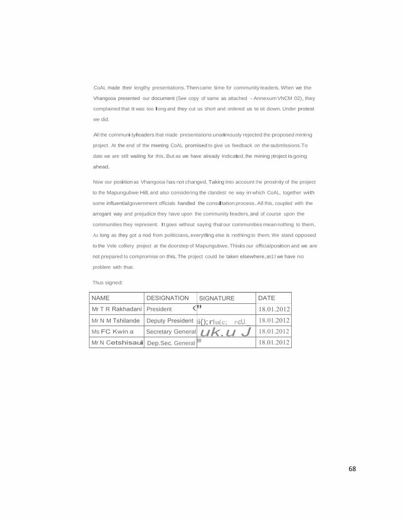
68
Mr T R President
Mr N M Deputy
Ms Secretary
Mr N
CoAL made their lengthy presentations.Then came time for community leadens. When we the
Vhangooa presented our document (See copy of same as attached -Annexum VNCM 02), they
complained that it was too long and they cut us short and ordered us to sit down. Under protest
we did.
All the communi tyleaders that made presentations unanimously rejected the proposed mining
project. At the end of the meeting CoAL promised to give us feedback on the stubmlssions.To
date we are still waiting for this.But as we have already Indicated, the mining ptroject is going
ahead.
Now our position as Vhangooa has not changed. Taking Into account the proximity of the project
to the Mapungubwe Hill, and also considering the clandest ne way in which CoAL, together with
some influentialgovernment officials handled the consultation process.All this, coupled with the
arrogant way and prejudice they have upon the community leaders, and of course upon the
communities they represent. It goes without saying that our communities mean nothing to them.
As long as they got a nod from politicians, everything else is nothing to them. We stand opposed
to the Vele colliery project at the doorstep of Mapungubwe.Thisis our officialposition and we are
not prepared to compromise on this. The project could be taken elsewhere, an1:l we have no
problem with that.
Thus signed:
Dep.Sec. General '"'

The Mopungubwo Culfu11l landscape (MCL) WOI1d Herilago s"e is located naar the
conHuence or llle 51\ashl and Unpopo Ri'let&. llle m118llll0 polt11 for Bot$wana, SouthAftlca
snd Zlmbabwe (soe Figs 1 & 2). The boundaries or the properly ate defined by tile
ax>rdmates:
NW comer 22"12'58"8 29'0!'22"E
NE cornllf 22'>10'10"8 29<>2 '04"E
SE c:omer22'14'15"S 29'31'35"E
SW comer 22"1T40"S 29.,2'00"E
This area 1$ bound by IIlii Linpopo River to lhe north,In the west by the Alldays-Pont Clift
toed; n the south by the Mossina·PonlOnft road and tile boondary or the farmRiedel;in tha
easl the boundary of the farm Riedel and an as yot unsurveyed line up tha western side of
lhe irrigated lands on the farm Welpe. In total, this area is 29 168.66 heclaru in
geographical extent, This"""' Is tikely lo inCill,... to doee to 100 000 heelaroipions lot
developing a Transfronder park Including adjacent araes of Botswana and Zi'n.bebwe are
reo ed.
According lo lhe nOfninallon dos$ier, tho Mapungubwe Culural L&lldscapa1$ canp<lsed ot
Remain$ or patac:ea- ('lolapungubwe period),
Archaeological remails teslllying to Mapungubwe'S growlh 900-1200 AD (ZI'IIzo,
Leopard'& Kopje}:
• Remains or early settlement Stone Age & Iron Age & rod< art;
'Natoral' landscape surnuoding lhe buillremains,
• lnlan ble hantage·MapungubWe HPIassociated with sacredness, belets. CUstOfns
and lrBdiUons of toesIccrnmunJUos.
• Lilling heritage: oontlntJnQ lr'!ldnlons and associations sucn as rain making, and
participotlonby local oonmunrtIn reburialC8femonies
• landscape sharing end hteradlon between lllt111ei'S and huntet111lhe<e!S
69

70
Although the landscape has evidence of human occupation dating back to millions of years.
the nomination dossier states that the landscape was nominated on the basis or the Iron Age
period, particularly the period between AD900 and 1300. The Mapungubwe Cultural
Landscape, whose rema ns are a testimony to the earliest known state societyin Southern
Africa (AD 900-1300), when viewed against the present day fauna and flora, and the geo
morphological formations or the Umpopo/Shashe confluence, creates an impressive
landscape of universal significance (Mapungubwe Nomination Dossier 200•0). The
occupation or the Mapungubwe CulturalLandscape (MCL) has continued over time anti
climaxing with the forced removalof localpeople during colonialism and the establishment of
private farms,ranches and mines (KYS 2011;see Annexure XX).
The MCL contains about 400 archaeological sites in the core area (listed property), some of
which provides evidence for the evolution of the state of Mapungubwe. The SEllllement
sequence of the MCL starts with the Early Stone Age, followed by the Middle and Late Stone
Ages with the Early, Middle and Iron Ages subsequently following (Huffman 2000; M:anyanga
2007). Recent research demonstrates the contemporary occupation of the landscape by
both hunter gatherers and farmers during the Iron Age to h storical t mes (Hall anod Smith
2000).In the last hundred years,farmers of European stock displaced localpeople creating
ranches.Mines have been established In the area showing the continual evoluti o:f this
layered landscape (KYS 2011).
Three main phases of development are recognized in the Mapungubwe Cultural Landscape
and these are associated wrth the Iron Age (Huffman 2007). The first phase, known as
Zhlzo, lasted from about AD 900-1020 and is best preserved at the site of Schroda.The
second phase,known as Leopard's Kopje or K2, has been investigated In most detuil at the
site known as K2 on the farm Greefswald and dated from about AD 1020-1220. The most
elaborate settlement during the third phase was on Mapungubwe Hill and the adjacent
Southern Terrace and dated from AD 1220-1300. AIthe height of its importance.between
AD 1220 and 1300,the Mapungubwe Cultural Landscape sustained a population of at least
71
9000 people. According to Huffman (2000), regular flooding of the Limpopo River provided
silt and water for crops. Grazing lands enabled stock to be kept. Elephants were hunted for
their ivory and other animals for their hides while mining provided iron, gold and copper ores
(Mapungubwe Nomination Dossier 2002). This landscape has evolved overtime with each
period leaving its marks, a process that continues to this day (Manyanga 2007).
At any given point in history, MCL witnessed new activities done at different scales.In
the last thirty years or so, archaeological excavations, cattle and game ranching,
intensive agriculture and mining have threatened the integrity of the landscape (see also
Mapungubwe Nomination Dossier). The establishment of the Park has cushioned the 400
sites within its borders from the ravages of development. Those outside are protected
through the National Heritage Resources Act and ancillary legislation.
1.5 Heritage at risk and mining
There are a number of World Heritage Sites at the risk of mining or modern development
encroachment in the form of scale and extent similar to Mapungubwe. A significant .number
of sites is found in Africa,and indications are that this number is on the increase. According
to IUCN,African natural Wortd Heritage sites that are increasingly threatened by commercial
mining and oil/gas projects include Virunga National Park in the Democratic Republic of
Congo (gold mining and other armed conflict posing a threat to a park with greatest diversity
of habitats of any park in Africa: from steppes, savannas and lava plains, swamps, lowland
and montane forests to volcanoes and the unique giant herbs and snowfields of Ruwenzori
over 5,000m high), Comoe National Park, Cote d'lvoire (the government is now issuing
licences to explore in West Africa's largest biosphere reserve),Mount Nimba Strict Nature
Reserve on the boundary of Cote d'lvoire and Guinea (its unique biodiversity is under threat
from miners extracting high grade iron ore), Dja Biosphere Reserve, Cameroon (home to
some of the largest and best protected rainforest tracts in Africa, is under threat from cobalt
mining on the precincts of the reserve), Kahuzi-Biega National Park in the DRC (threat to
gorillas due to illegal eolian and gold mining), Selous Game Reserve, Tanzania (uranium

72
exploration within the property, a 50,000 km2 sanctuary to a large numbers of elephants,
black rhinoceroses, cheetahs, giraffes, hippopotamuses and crocodiles, 1relatively
undisturbed by human impact), A'ir and Tenere Nature Reserve , Niger (the largest protected
area in Africa, covering some 7.7 million he, due to its unique desert landscapei, ora and
fauna Is under threat from petroleum prospecting activities). Manovo-Goundat Nature
Reserves, Central African Republic, (the largest savanna park in west and central Africa,
located at a major biogeographic crossroads of central Africa,being threatened by gas and
petroleum exploration), Mana Pools National Perk, Sapi and Chewore Safari Areas.
Zimbabwe(lllegal gold.copper and uranium).
These naturalor culturallandscapes may be regarded as heritage at risk.These mining and
exploration projects are in their nascent stages, which means that governments, mining and
oiUgas companies, financial backers and other stakeholders have the opportunity to make
well-informed decisions for present and future generations by committing to preserving the
heritage and thereby also safeguarding the livelihoods of local people and Africa's long-term
sustainable development.
Other world examples include Larentz National Park, Indonesia, with the highest level of
biodiversity in South-East Asia (gold mining taking place directly in the national p<trk), The
Cave of Hands (Cueva de las Manos), Argentina (where gold mining Is now taking place
within the associated landscape, threating outstanding panels of rock art in the Pinturas
River ravine),Yellowstone NationalPark,USA (waste contamination, sewage leaka•ge,alien
species and gold mining, all posing a threat to the park's ecology and wildlife), Kakadu
National Park, Australia (uranium mining is taking place inside the park, posing t9 risk to
indigenous people living there), Donana National Park, Spain (metallic wasile spill),
Zhoukoudian, China (quarrying within the site precincts, leading to loss of important
geologicalspecimens).
A wide range of conservation measures have been suggested or implemented to minimise
threats to OUVs for which the world heritage sites adjacent to the mining repres,snt. The

73
conservation,protection and management of Mapungubwe should draw from some of these
examples,In respect of granting of mining licences.environmentalmanagement, ccommunity
development, stakeholder participation, etc. the ma n lesson from this comparative study
is that if done within a compliance framework heritage and development can co-exist.
1.6Summary
In conclusion, each generation has successively left its mark on the MCL since time
immemorial In recent times, population pressures and the need for economic devEJiopment
have threatened the existence of remains from bygone generations, some of wtl ch have
outstanding universal value to humanity. Such threats and impact must be Identified,
managed and mitigated to ensure availability for present and future generations. It must
always be borne in mind that the OUVs of Mapungubwe are based on the period AID 900 to
1300 (Mapungubwe Nomination Dossier 2000). As such, threats to the Integrity of sites
dating to this period constitute threats to the OUVs. The threats to other resources such as
rock art and Stone Age·sites are adequately covered using the South African National
Heritage Resources Act. _
2_ CONCEPTUAL APPROACHES
Given the sensitivities surrounding the Mapungubwe Cultural Landscape a nu1mber of
conceptual approaches were utilized to distill results that are specific to all the important
issues. These approaches were designed to assess the impacts and oppo·rtunities
associated with different land use activities around the Mapungubwe Cultural Landscape but
with special reference to the South African side.They stem from the localand international
best practice represented by ICOMOS and Its regulations,UNESCO and Its regulati-ons and
guidelines,as well as the locallegislation and compliance framework.
2.1.Understanding OutstandingUniversalValue (OUVs)

74
The World Heritage Convention Concerning the Protection of the World Culturaland Natural
Heritage (1972) provides a framework for listing natural and cultural heritage of universal
value as World Heritage Sites. It also notes that globally, heritage is at risk <3nd that
"deterioration or disappearance of any item of the cultural or natural heritage cons:titutes a
harmfulimpoverishment of the heritage of all nations of the world".Heritage protection at the
national level very often remains incomplete because of the scale of the resources which it
requires and of the insufficient economic, scientific and technological resources of the
country where the property Is situated.It Js for this reason that the Convention regards parts
of this heritage to be of outstanding interest and therefore need to be preserved a's part of
the world heritage of mankind as a whole.
The ooncept of outstanding universal value (OUV),first discussed by UNESCO in 1EI76, was
interpreted as "meaning that a property submitted for incul sion In the WHL should represent
or symbolize a set of ideas or values whTch are universally recognized as important, or
having influenced the evolution of mal)kind as whole or at one time or another". Since then,
a number of criteria have been set to measure OUV .(see Jokilehto 2005), and a1!its 2sr
session, the World Heritage Committee agreed with the folloWing definition, as snt out in
paragraph 49 of the OperationalGuidelines (2005):
·outstanding universal value means cultural and/or natural significance which is so
exceptional as to transcend national boundaries and Lo be of common import<rnce for
present and future generations of all humanity. As such, the permanent protection of this
heritage is of the highest importance to theinternationalcommunity as a whole...."
The Committee recognized that the definition and application of OUV would be subject to
evolution over time.Ttlis evolution is reflected In the changes that have been made to the
criteria and in their application.The Committee also noted that the concept of OUV is often
poorly understood and requires improved communication generally at the site level and
recommended that the identification of OUV be achieved with the participation by
stakeholders Including local communities and indigenous people. The developmenrt of the
75
statements of OUV (SoOUV) for World Heritage properties as required by the Operational
Guidelines for the Implementation of the World Heritage Convention (UNESCO 2008) was
meant to set out clearly the attributes that refled OUV and the links between them. Integrity
and authenticity are also useful.
There are also concepts such as 'limits of acceptable change' and 'absorption capacity'
which are being discussed within the framework of OUV. It is not clear at this stage how
usefulthese concepts are,or how they may be operationalized. There Is also no a 1reement
on how to revive heritage Value that has been eroded (ICOMOS 2008).
The Mapungubwe Cultural Landscape, whose remains are a testimony to the eartie!:>kl nown
state society In Southern Africa (AD 900-1300), when viewed against the present day fauna
and flora,and the geo-morphological formations of the Limpopo/Shashe confluence,creates
an impressive landscape of universal significance.Mapungubwe was placed on the World
Heritage List in 2003 on the basis of the following criteria:
Criterion (ii): The Mapungubwe Cultural Landscape contains evidence for an important
interchange of human values that led to far-reaching culturaland socialchanges in Southern
Africa between AD 900 and 1300.
Criterion (iii): The remains in the Mapungubwe Cultural Landscape are a rennar1<ably
complete testimony to the growth and subsequent decline of the Mapungubwe Stalte which
at its height was the largest kingdom in the African subcontinent.
Criterion (iv): The establishment of Mapungubwe as a powerful state trading thro•ugh the
East African ports with Arabia and India was a significant stage In the history of thE• African
sub-continent.
76
their own autonomous repubflcs within the Russian state,and the Canadian lnui•lttht> form
a majority of the territory of Nunavut (created in 1999).
It is also sometimes argued thatit is important for the human species as a whole to
preserve a wide range of culturaldiversity as possible.and that the protection of
indigenous culture is vitalto this enterprise.
An example of this occurred In 2002 when the Government of Botswana expelled all the
Kalahari Bushmen known as the San from their lands on which they had lived for at least
twenty thousand years. President Festus Mogae has described the Bushmen as "stone
age creatures• and a minister for localgovernment,Margaret Nasha, likened public
criticism of their eviction to criticism of the culling of elephants.In 2006, the Botswana High
Court ruel d that the Bushmen had a right to return to their land in the Central Kalahari
Game Reserve.
Indigenous Viewpoints
Indigenous peoples are increasingly faced with threats to their sovereignty, environment and
access to naturalresources.Examples of this can be the deforestation of tropicalrainfo,rests
where many native tribes'subsistence lifestyles are threatened.Assimilative colonial po,Jicies
resulted in Issues related to aboriginalchild protection.[Wikipedia][For further Information
on the rights of indigenous peoples,see the attached annexes from the African Commission
on Human and Peoples' Rights on the Declanatlon United Nations Declaration on the Rights
of Indigenous Peoples,as attached:VNCM 20,I.e.paragraphs 14 to 45]
In this way we also believe that we have managed to clarify the fact that the VhangoDa•
Vhavena are as good an autochthonous people of Lukungurubwe in general,and the
Mapungubwe CulturalLandscape in particular, as the Australian aborigines and other
aboriginal peoples of the world are.And so we trust that no one will ever ask where they
came from or when they came here. We equally believe that no one will ever question tJUr
involvement In any Issue affecting Mapungubwe, both now and In future.We believe th13se
stereotypes and bigotries are now history.Southern Afr ca does not belong to former
77
development tends to eliminate unique features of the landscape. Sense of place may
appear a fuzzy or purely subjective a concept, but there are clear definitions that begin to
narrow its focus.Some definitions perceive sense of place as those things that add up to a
feeling that a community is a special place, distinct from anywhere else (Daniels 199), or
something that results gradually and unconsciously from inhabiting a landscape over lime,
becoming familiar with its physicalproperties, accruing history within its confines (Ryden,
1983).
In the context of the World Heritage Site of Mapungubwe,our approach uses the clefinition
as offered by Jackson (1984) who views it as a place, permanent position In both the social
and topographicalsense, which gives communities an identity. In this regard, sense of place
Is primarily about the human landscape, the human legacy of impact on the land, end
memory.There are other characteristics about sense of place which include naturalfiaatures,
patterns of human settlement,and socialrelationships,since the connection between people
Is a key component of place, and something that Is determined by local knowledne.best
expressed by the native population.In the case of Mapungubwe, sense of place would best
be expressed by descent communities, although we acknowledge that It has also bE!en part
of the construct arising from centuries of layering,Including colonialism.
Descriptions of place can take many forms, but one of the most effective, with res;pect to
heritage management Is an Inventory of heritage resources. A comprehensive profile of both
the naturaland culturallandscape aids not only Inpreservationof existing resources,but can
provide direction for future growth. Quantifying sense of place is, in our view, conserving
those resources that make such a place unique (See Annexure XX, Visual /mpac:t). Our
approach here seeks to relate this concept with OUVs as presented above. In a lan.dscape
however, some places have a deeper sense of place when compared to othe:rs. For
example,former capitals such as Mapungubwe Hillmay evoke a deeper sense of place than
the smaller sites.Thus the concept of sense of place is inextricably linked with signiftcance.

)j
( C',/.f,J Cl""f\
m&m@@ IY1l©@illJ lfWJ - [ UW A MOVEMENT OF THE ABORJGINALCITIZENS OF THE UNITED KINGDOM OF VENDA OF YORE {06a.9U.Nl'OI
ENQ;TME PRESIDENT 1!10786029271/ll76)!106547/Rotn oi>wobm.JJI.col THBEC. GENEi!Al(il 0823G6911S
SUBMISSION OF THE VHANGOt::JA-VHAVENI;IA NATION
TO
COAL OF AFRICA LIMITED
VEL£ COLLIERY PROJECT
ON 02 JULY 2011 BY
MR T R RAKHADAN"
PRESIDENT OF THE VHANGO!JA NATIONAL
CULTURAL MOVEMENT AND SPOKESPERSON
OF HIS MAJESTY
KING TSHIDZIWELELt:

1. A BRIEF HISTORY OF THE VHANGO A-YHAVENQA NATION
We the Vhangooa nation are the aboriginal[Indigenous] citizens of the land Vena of yore,
then known as Lukungurubwe [now the SADC region]. The whole of this region was then
commonly known as the Vhangol)a United Kingdom of Ven a.or Thovhele State as some
affectionately called it, withthe now internationally acclaimed and admired Mapungubwe
CulturalLandscape as its capital. [See Annexure V3A,38,VNCM22].This powerfuland
affluent Kingdom was led by His Majesty King Tshidziwefefeephawe.(See Annexure V:l'].
Our kingdom was composed of many district centres which were spread throughout ff.s
length and breadth,for example: Thophomabwe [now Matopo Hills], Great Dzimbabwe,
Khaml, Ma/ungudzlof Mbedzi Matibe, Musiningira of MunyaiMabanga Phaswana, Ha
Mubvumela of Muronga [Maputo],ifurudzi of Munyai Mariwadu [Botswana], Ha-Muravha of
MunyaMl uravha[Marabastad-Pretorla),Mahenlof Mulovhedzlemahenl[Mafikeng],
Vhilavhila of Mukwevho J;Jevhllavhila [Bela Bela/ WarmbadiWarmbaths],Ha-Lutanga
[Swaziland], Ha-Tshikororo of Mudau Jshikororo [Ga-S'kororo], Dzananiofedzanani
[Tzaneen].Vhulovhedzlof Mulovhedzi Musehane/Ralushai[Bolobedu, now Mukwevho
Modjadji's domain],Lumbelule of Mbedzielumbelule (Lepelle],Bulugwane of Kwin a
Mas vhelele Matshavha [Polokwane],Vhugogwa of Mudau tJev u ogwa (Botlokwa],Ha
Mugwabana of N<jou Mugwabana [Mokopane],Musina of Muleya J'::lemusina,
Madzivhariombe of Mbedzei madzivhariombe [Giyanij,Miyohe-of Matibeemiyohe
[XIkundu],Thulamela of Makahane.to mention but just only a few of them.Now all these
and many other district centres were ruled by Mahoslmahulu (paramount chiefs] who wem
deployed and controlled by their king, his majesty King Tshidzlwelele of Mapungubwe.[S•:le
Annexure V3A&B].
The organogram of our royalleadership stands as follows:
THOVHELE [KING)
MAHOtMAHULU [PARAMOUNT CHIEFS]
MAHOSJ [SENIOR TRADITIONAL LEADERS]
MAHOSANA [HEADMEN]
! VHAKOMA [PETIY HEADMEN]
Now the Vhangol)a have at laasiseven evolutionary names,each of which attests to the fact
that we have been here for millions if not for billions of years [See Annexure V7].These are:
Zwisike p.e.the originalcitizens/ aboriginal people/ autochthonous people/ first people];It is
common cause that all the other groups which have finally come here to make this land their
home had left their countries of origin.Until today they alcan clearly recount how and why•
they decided to leave their countries and embarked on exiles untilthey landed herein
Venc;fa, the land of the aboriginalVhangol)a.So far there is no clue or evidence as to the
arrivalof Vhangol)a in this land.From the late L T Marcie's Makhulukuku we read:
"Vha Nngol)a ndilushaka lu sa c;lihwizwavhuc;lihune vha bva vhe hone,hezwivha tshic;la kha
he!ino11no pfi Venc;fa zwino l)amusl. A hu na lusevhe{lllwa muzwila we vha c;fa ngawo,
"(Marole,1966, 6}
Nowloosely translated, the above quotationwould read something like this:
"Now nobody really knows the origin of the Vhangol)a nation as we find themIn what is
today known as Venc;fa.There is virtually no idea or clue about how they happened to come
here."[Maroie.1966,6]. .
Based on the above assertions therefore,suffice it to say that they are the aborigines,
autochthonous, indigenous,first Inhabitants,owners and rulers of Venc;fa.
MungoQa [owner of land teaming with meat (animals}, i.e.Muthu wa shango J.a l)ama;mu +
ngo +!JB = Mungol)a;
Mubikwanaive [loosely translated It wouldmean the one who was cooked with the stone
(i.e.one who witnessed the formation of many mountains and rocks during volcanic
eruptions}.This Is further attested by both human and animal footprints on the rocks, which
serve as testimony that the Vhangol)a have long been In this territory,somuch so that they
made such marks when the rocks were still soft warm.

_·-;. 2; ,- ---· : .: .
Muvenqa (Ven.;la comes from Vele [seed/maize) !a u fhedza Ia; Ve + nlla= Venqa.I.e.
the seed/maize that conquered hunger]. (Then Muvenqa means the owner of the fertile la1nd
that produces the maize that conquers hunger);
Ngwaniwapo (one who was found already there];
Ntangiwakugata [the first to settle/live In a place];
Tshldzatshapo [the (local) graves which were found there.i.e.all over the entire kingdom by
those who migrated into it].IIwere the Vhangol)a who.as the first inhabitants of the area..

gave names to all the riVGrs,mountains,trees,birds,grass,stones,places, throughout the
entire kingdom,which names are sliD in existence even today albeit some having been
corrupted. (See Annexure V14].Our ruins are round all over the land Vena or yore.WEare
the indigenous people of Lukungurubwe or southern Africa as It Is known today.
Now the Vhangof)a are easily identified amongst the other African nationalities by their
family names/mitupo or totems,and these are:N ou (elephant], Mudau (ndau/lion) [e.g.
Dau,Tau, Bataungj,Kwin a.Mukwevho [nguluvhe/kolobe,boar] (e.g.Modjadjithe rain queen,
Manamela, Kgopa, Muguboya,Sekgopo, Mamabolo etc.), Mbedz.i (tivha/dzivha/IPOOI)
(e.g.Bakwena/Bakoena/Ngwenya, Mhlanga, Mlambo/Musikavanhu of Chipinge, Dzivaguru
or Gwangwava-Mount Darwin,Matlbe of Mtetengwa,Madzlva of Makoni!Maungwe Coun1try,
Masunda of Ha-Shabani,ehoreka of Mungariematombo of Hurungwe,Mutwiri of
lnyanga,Moshoeshoe of Lesotho,etc.), Munyai[pfef)e/baboon] (e.g.Mathebuia.
BaloyiNaloyi,Muravha,etc],Mudzanani(pfe!)elbaboonj, Mutwanamba,Muleya, Muluvhu,
Mufamai[nguluvhelkolobelboar],Mulovhedzi Mu!)arini[f)arVbuffalo],Munzhelele,
Mu!avhatsindi[n ou/elephant],Murundwa [nQou/elephant],Mulembethu,Khomola
(l)arVbuffalo].Now all the people who fall under these totems are Vhangof)a,and therefore
we befieve they compose a very considerable percentage of the black population both in
South Africa as well as in southern Africa.
We believe the Vhangooa nation also adequately meets the United Nations' definitions cof
indigenous or aboriginalpeoples and their rights as recorded in the following documents:
Indigenous peoples [From Wikipedia,the free encyclopaedia]:
Indigenous peoples are people,communities and nations who claim a historicalcontinuity
and culturalaffinity with societies endemic to their original territories that developed prior to
exposure to the larger connected civilization associated with Western culture.These
societies therefore consider themselves distinct from societies of the majority cultures that
have contested their culturalsovereignty and self-determination.
They havehistorically formed and still currently fonm the minority/non-dominant sectors
within majority-culture societies and are intentioned towards preserving, reviving,and
enhancing the efficacy,cohesion and uniqueness of their tradiUonalsocialvalues and
83
customary ties along with a conscientious effort lo lr< nsmit this knowledge to future
generations. This forms the basis of contemporary campaigns for reclamation of their own
representationalsovereignty and continued existence and recognition as peoples who desire
to live according to their own culturalattributes, socialsystems and structures of law...
Other related terms for indigenous peoples Include aborigines,aboriginalpeople,native
people, first people, fourth world cultures and autochthonous.(Wikipedia-UN]
Who Are the Indigenous People and What Makes Them Different?
There does not seem to be one definitive definition of indigenous people, but generally,
indigenous people are those that have historically belonged to a particular region or country,
before its colonization or transformation into a nation state,and may have different-often
unique-cultural,linguistic, traditiona,l and other characteristics to those of the dominant
culture of that region or state.
In some parts or the world,there are very few indigenous people,while In other parts they
may number into hundreds of thousands,even millions...
It is eStimated that there are more than 370 miirlonindigenous people spread across 710
countries world wide.Practicing unique tradltlons,they retain social,cultural,economic and
politicalcharacteristics that are distinct from those of the dominant societiesin which lh1ey
live. Spread across the world from the Arctic to the South Pacific, they are the descendants
according to a common definition- of those who Inhabited a country or geographicarl 1ion at
the time when people of different cultures or ethnic origins arrived.The new arrivals be<:ame
dominant through conquest,occupation,settlement or other means...
Understanding the Term"Indigenous":
Considering the diversity of Indigenous peoples,an officialdefinition of "ni digenous·
ha;not been adopted by any UN-system body.Instead the system has developed a
modem understanding of this term based on the following:
• Self-identification as indigenous peoples at the Individualleveland accepted by the
community as their member,
• Historicalcontinuity with pre-colonialand/or pre-saltier societies.

84
Strong link to territones and surroundlno naturalresources,
Distinct social,economic or politicalsystems,
Distinct language,culture and beliefs,
Form non-dominant groups of society,
Resolve to maintain and reproduce their ancestralenvironment and systems aJ;
dist nctive peoples and communities.
Culture and Knowledge
Indigenous peoples are the holders of unique language knowledge systems end beli•sfs
and possessinvaluable knowledge of practices for the sustainable management of natural
resources.They have a specialrelation to and use !heir traditionalland.Their ances1ral
land has a fundamentalimportance for their collective physicaland culturalsurvivala1s
peoples.Indigenous peoples hold their own diverse concepts of development, based on
their traditional values, visions, needs and priorities.[UNPFII-FACTSHEET]
Indigenous Rights, lssues and Concerns
Wherever indigenous culturalIdentity is asserted,some particular set of societalissuos
and concerns may be voiced which either arise from (at least in part), or have a partic:utar
dimension associated with their Indigenous status. These concerns will often be commonly
held or affect other socieftes also,and are not necessarily experienceduniquely by
Indigenous groups.
Despite the diversity of indigenous peoples,it may be noted that they share common
problems andissuesin dealing with the prevaifing,or invading society.They are generally
concerned that the cultures of indigenous peoples are being los1 and that Indigenous
peoples suffer both discrimination and pressure to assimilate Into their surrounding
societies. This Is borne out by the fact that the lands and cultures of nearly all of the
peoples Hsted at the end of this art cle are under threat. Notable exceptions are the Salcha
and Komipeoples (two of the northern Indigenous peoples of Siberia), who now control'

85
their own autonomous republics witllln the Russian state, and the Canadian Inuit,vllm form
a majorfty of the territory of Nunavut (created in 1999).
It is also sometimes argued thaiit is important for the human species as a whole to
preserve a wide range of culturaldiversity as possible.and that the protection of
indigenous culture is vital to this enterprise.
An example of this occurred in 2002 when the Government of Botswana expelled all the
Kalahari Bushmen known as the San from theirlands on whichlhey had lived for at least
twenly thousand years. PresidenlFestus Mogae has described the Bushmen as "stone
age creatures" and a minister for localgovernment,MargareiNasha,likened public
critic sm of the r eviction to criticism of the culling of elephants.In 2006, the Botswana High
Court ruled that the Bushmen had a right to return to their landin the Central Kalahari
Game Reserve.
Indigenous Viewpoints
Indigenous peoples are increasingly faced with threats to their sovereignty,environment and
access to naturalresources.Examples of this can be the deforestation of tropicalrainforests
where many native tribes' subsistence lifestyles are threatened. Assimilative colonial po•llcies
resulted in Issues related to aboriginalchild protection.(Wiklpedia] [For further lnformaUon
on the rights of indigenous peoples,see the attached annexes from the African Commi ;slon
on Human and Peoples'Rights on the Declaration Unfted Nations Declaration on the Rights
of Indigenous Peoples,as attached:VNCM 20, i.e.paragraphs 14 to 45)
In this way we also believe that we have managed to clarify lhe fact that the Vhangooa·
Vhavenc;la are as good an autochthonous people of Lukungurubwe in general,and the
Mapungubwe CulturalLandscape in particular, as the Australian aborigines and other
aboriginalpeoples of the world are. And so we trust that no one will ever ask where they
came from or when they came here.We equally believe that no one willever question <Jur
involvement In any issue affecting Mapungubwe, both now and In future.We believe th1ase
stereotypes and bigotries are now history.Southern Africa does not belong to former
86
migrant peoples.who came here as dissidents.hunters and gatherers,fortune-seekens,
refugees,discoverers,traders,etc.; but to the first people [known as the VhangoCia] whose
origin cannot be known save to say that they were found right there.
Criteria for Involvement or Participation in this Project
We the Vhangooa participate In this project as the direct descendants of the owners and
rulers of the Mapungubwe kingdom,not as an Interested party or stakeholder. It will be a
mistake for Coal of Africa just to try and bring In as many people as could be found
Interested whereas they disclaim any thorough knowledge of and have nothing to do with
Mapungubwe.
Just as it happened during the preparations for the reburialprocess in 2007, we are stiill
opposed to the blanket inclusion of different groups,simply because they claim that the'y
belong there.If any group or indlvldualclaims their relationship with or connection to
Mapungubwe,let them produce their history and/or anything that could show that they
belong to it. Saying this we know full well that there are those like the Vhatwanamba of
Tshivhula now subdivide.d into three families, namely:Tshivhula, Matshete andishivh<l, as
well as the Vhalemba group.
We need to prove it here and now that these groups cannot lay claim to Mapungubwe a1s
belonging to them or any of their ancestors.
A VHALEMBA
It is common cause that the Vhalemba are the Black Jews.Their country of origni is
neither Venga nor any African country, they originated In Judea. (See Annexure VNCM
20 as attached].
Now according to Magdelle Raux, who did research among the Vhalemba, this is what
we hear of them:
A preliminary investigation Into the Semitic origins and misssionary initiatives of some
Lemba communities In southern Africa.

87
Magdelle Roux
ABSTRACT
"The Lemba live among other ethnic groups in southern Africa, but consider themselves to
be Israelites who, after the Babylonian exile,migrated to Africa.The possibility that the Lemba
might have a Semitic ancestry (embedded In an African culture) Is further suggested by their
preoccupation with religious practices like animalsacrifice, ritualslaughter,foocl
taboos,circumcision rites,and endogamy.This article Is primarily based on field research
(participant observation and interviewing) among the Lemba people living mainly In the
northern and eastern provinces of South Africa and in southern Zimbabwe. Attention is
drawn to the way in wllich the identity of the Lemba is manifested through the traditions. of
their origin,some key cultural-religious practices (with an Old Testament resonance), the
Initiatives they took in their mission,and their assimilation into Christianity.
INTRODUCTION AND METHODOLOGY
The Lemba (also known as the Balemba, Basena,Bason!,Vamwenye, Varemba or Balepa)
live among other tribes in southern Africa,speak the language of the populations
surrounding them,attend localschools and hold positions In those communities.But their
uniqueness lies in the fact that they regard themselves.as being an offshoot of the Yemenite
Jews,from a city called Sena (cf. Neh.7:38 and Gayre of Gayre 1967 :16), who centurl·es
ago crossed the "Phusela" (although they do not know what Phusela was) and came to
Africa.Here they rebuilt Sena,perhaps in more than one place, and helped to construct a
great stone city which they identify as Great Zimbabwe (Mathlvha 1992), the nuins of wtlich
have Intrigued archaeologists for the last 100 years."
And one of their leaders, the late F C Raullnga,In a submission to the former Steering
Committee ontheMapungubwe Human Remains Reburialconfirmed whalle Roux said
of them:
THE LEMBA RELIGION, CULTURE, TRADE AND HISTORY
1. HISTORY
The Senas left Judea about six thousand (6 OOO)years ago during the riot of
Nebuchadnezzar king of the Chaldeans of Babylonia (Mesopotamia) when the Jews were
88
taken Into exile in the times of prophet Jeremiah about 586 BC.They left under the
leadership of Buba (Judah) and settled in Yemen where they built the city of Sena named
after Senaah in Judea, hence their name "senas",descendants of Senaah (Ezra 2:35,
Nehemia &:38).Buba ruledin Sena. Hamisisucceeded Buba and ruled in Sena.Hamisibuill
the city of Phusela In Yemen.Dur ng his reign,Hamisi led the Senas across the red sea into
Africa.
They divided into two groups, one group went to Ethiopia (Abyss nia),those are the
Falashas.Hamlsiled his group along the East Coast to the south and settled between
Kenya and Tanzania under Hamlsl. They named the place Sena II in remembrance of Sena I
in Yemen.The LembasiSenas lived at these places in Africa: Sena Ill inDelagoa Bay under
Bakall,Chilambakufa in Zimbabwe under Seremane, Gokomele in Zimbabwe under Harnlsi,
Zlmbabwe Hills under Tovhakale, ShabaniHills In Zimbabwe under Mhani,Mbelengwa
mountains in Zimbabwe under Hadjiwhere they were for the first time in Africa called
Lembas In remembrance of the city of Lemba (libba) near Jerusalem in Judea during the
Maccabean (Judas Macabeus) rule about 168-63 BC, Oumbuslmountainin Zimbabwe
under Sadiki.
B. VHATWANAMBA OF TSHIVHULA
It is common cause that the Vhatwanamba clan proper are Vhangoaa.Even as we
speak, in our movement,I.e.the Vhangooa NationalCulturalMovement, we have a
number of Vhatwanamba who come from different royal families who are members of
the organization.
Now according to the former Veni;la government ethnologist, the late Mr W M 0 Phophl, the
Tshivhula people who are here now as stakeholders came from Rhodesia,and therefore
cannot claim anything concerning Mapungubwe.[See Annexure VNCM 21 as attached].
Likewise, the Matshete and ish ivha people, who In any case are the younger brothe t.o
Ieday's Tshivhula.cannot really claim to belong to Mapungubwe save to say that they did
stay there sometime, but having found the originalresidents there,although some of them
had already lefl [See Annexure VNCM 22 as attached)

2. OUR SUBMISSION
Now It is a well-known fact that Mapungubwe is our national heritage.Not only is
Mapungubwe one of the seven proclaimed World Heritage Sites in South Africa, but it hoas
also gained internationalimportance as a result of its rich culturaland historical
significance.Mapungubwe also stands as a symbolof the highest honour in the land.This,
righUy so since the erstwhile Mapungubwe Kingdom of the Vhangooa then ruled the emire
sub-Saharan Africa,as wellas the fact that it very well embodies our essence and pridE!of
being blacks in generaland of being VhangoQa-Vhavena in particular,and also the art,
skill, wisdom,sophistication,civilisation and complexity of those our ancestors, the iron
age and/or stone age people whose incredible and unprecedented success still baffles
many today.
Now we believe that if the unconditionalNew Order Mining Right [NOMR] awarded to Coal
of Africa were to go ahead,it would haveadverse impact and untold harm upon the World
Heritage Site status of Mapungubwe, which might compelthe United Nations to withdraw
such status.Not only that, Mapungubwe Is our nationalheritage,the pride of all African:> in
general,and in particular the blacks,not only those is South Africa but across the entire
continent. Now any disturbance to the ecosystem, the fauna and the flora, the hundreds of
thousands of the remains of our ancestors,as well as to the entire trans-fronUer park
environment and population,just for the sake of short term profit gains by a $1T1all group or
selfish capitalists, naturally attracts criticism and objecUon by all who love their heritage.. A
project with a projected lifespan of between twenty to thirty years, yet it Is expected to
destroy the VhangoQa-Vhavenga·s heritage, which took our ancestors centuries to build!. ,ve.
Mining and ecotourism cannot cc;exist,neither are,..prepared to see the latter disturbing the
former in any way.This heritage was handed down to us by those who traversed this land
since time immemorial,and which took countless generations to be built. We therefore
don't see any reason why it should be destroyed now and In the process, we be the onEIS
who have decided to rob future generations of the heritage meant for them both by God
Almighty and by the ancestors.
May we also draw the attention of Coalof Africa and perhaps any other interested party to
the fact that not only are we claiming that Mapungubwe Is our heritage.We are not only
verbally claiming it.Right now as we speak, our King,His Majesty,the Honourable Mr .1!1.N.
Tshidziweleleephawe has lodged a land claim on Mapungubwe with the RegionalLand
Claims Commission. And we are only waiting for the Commission to conclude Its work con
the issue.It is or.!y we t.'le Vhar.go(.la who have and who can make any such claim let ihe
sacred site.We have again made a kingship claim with the Commission on Tradftlon1al
Leadership Claims and Disputes,and as we speak, thematter is about to be finalised by
the High Court,since there was some meddling as far as the Commission results we1re
concerned.
Tourism versus Mining
We need to inform Coalof Africa that Mapungubwe Is our heritage and shrine as a nation.
Mapungubwe rneansmore that the erstwhne capitalcity of our kingdom.It must be
realised that our ancestors still lie there, hence our Involvement in the reburialproces!lin
2007. [See Annexure V6A].Mapungubwe Is our nation's sacred site. Those of us who still
believe in ancestralworship do visit the place from time to time to perform their rituals
there.So we don't see any reason why this should be disturbed by the envisaged mining
project.
So far we as the VhangoQa, the bon fide descendants of the owners of the Mapungubwe
area,are relatively satisfied with Mapungubwe being used as a tourist attraction, since this
does not harm the environment In any feasible way.It is our belief that if the mining project
were to go ahead,tourism development In the Mapungubwe CulturalLandscape will bt
negatively affected by the round-the-clock lighting,blasting and noise and these will
destroy the sense of the place in a permanent way,and it goes without saying that the
same willalso apply to the sustainable job opportunities from tourism and tourism growth.
This project is totally incompatible with tourism activrties,and should therefore be objec ed
tot
Everyone of us knows that CoalOf Africa Is an Australian company.It is common caus•e
that the government of Australia recognises both the aboriginalpeople of that country,their
rights and their sacred sites.But we find it ironic that Coalof Africa is adamant that the '
want to do mining here at Mapungubwe,even when we as the aborigines here are
unequivocally saying that they shouldn't Imagine if we were to go to Australia today to ,jo
mining at Ayer's Rock. And when the people objected to !.his, we would calm them down by
saying that we were going to create lots or jobs lor the aborigines,give their children
bursaries and pay some royalties to their trust funds.It must be borne in mind that
Mapungubwe is the culturalcapitalof both South Africa and the southern African region as
a whole.So if this initiative were to go ahead, we will continue to oppose it since we were
not consulted at its inception, and we don't undar tand whyIt should be done exactly
where it Is now envisaged.
Now Chapter Two,Section 24 of our countly's democratic Constitutionmakes provis )n for
the protection of the heritage and environment for future generations where It says:
Everyone has the right-
Environment
(a) "To an environment that is not harmfullo their heallh or wellbeing,and
(b) To nave the environment protected, for the benefit or present and future generations,through
reasonable legislative and other measures lhat-
(1)prevent pollutior) and e<:ologicaldegradation;
(il) promote conservation;and
(iii) secure ecologicalsustainable development and use of naturalresources while promoting
justifiable economic and socialdevelopment."
It is therefore our submission as Vhango!)a-Vhavenga nation that we are not opposed to
the Issue of mining as such,nor are we oblivious of the fact that there are lots of financ:ial
spln-offs to some people, as wellas the much needed job creation.All we are saying h>
thaias an Australian Company,Coalof Africa would never do mining on the shrines or
sacred sites of the aboriginalpeople In Its mother country.And so we do·nunderstand!
why the same should be done here.right at the doorstep of our home town!And if this
project were to go ahead against this background,it would therefore be tantamount to both
culturaland racialprejudice.And we will under no circumstances allow any such activities
to be carried out on our culturallandscape without resistance. MapungubweIs our
heritage!We will never let go of it nomatter what reward is offered!
And to substantiate this further, we quote from the former Venga admni istration's
Commission on Land Matters which wrote to the then white South African regime and;aid"
"Before the decision-makers of the Republic of South Africa, embark on the delk:ate
issue of determination of boundaries, we wish to sound a warning that any lland
arrangements which excluded historical and traditional considerations, were the source of
friction, misunderstandings and wars throughout the ages. To substantiate this statement
does not require any Intensive research as all historians and politicians are aware of the
mistakes committed by the delegates who assembled in Viennain 1815 and at Versailles in

1919 In which settlements, territorial arrar.gemsnts remained a sore in the hearts of the
dispossessed. The vanguished nations had no alternative but to bear the brunt for some
moments,and when time came,took up arms to regain the los1territories...•
We therefore would like to furthermore plead wilh our government lo withdraw the license
given to Coalof Africa as soon as possible.They can get any other place to do their
mining,not at and/or around Mapungubwe. otherwise if this were to get ahead, the courts
of law would have to be approached for assistance.This also applies to any other inl•ended
or prospected mining actlvy in and around Mapungubwe.We will always oppose any
such activities.We are also aware that we are never consulted whenissues affecting
Mapungubwe are being discussed. We find this very much unfair and so we condemn it In
the strongest terms.
Thus signed:
Name Designation Date
Mr.T R Rakhadani VNCM President
Mr.M N Tshllande VNCM Deputy President
02.07. 011
02.07.2 011
Mrs F C Kwinga Secretary General 02.07.2011
Mr Netshisaulu Dep.Secretary General 02.07.2011
Mr R. Luvhimbl Publicity Secretary 02.07.2011

6.5. Map plans ofVele Colliery
r ,
'jtl'•.
Figure 29.Site plan over the planned mining areas of Vele colliery.Map: Coal of Africa.

I·
tl'?
""""""I-
!
f.-.
--·--··-··-;:;;.. . !
... --"'""'""'"""
---=
------ -- ""'J-..:.... ...
<:::!' 0'1
_.,. _,. : -.....-......-.......... ..j(:..:;. --
r -;-- - - -!... -- ...
i n•Q PHASE2B .r: _:..
l»tr u.> ,-
· ·- ·- · - . .-.................... -•• ........ • ;:_ ----.:.;!:'="
· - • 1
: 1.1 tJ . . ··-··- -.. f I '""""'
.'!-
. , c, l j -C_\ f
••----1::=::; :== =
.lt'"-- j 1> 7 l j_
ni t :
0
I
..! f: '"..".."."..". ' :-:;·-·.-·-:!:' i:i:iL.._,·,rt.
: 1:1.
I uf l ---··-·-.-.:!:: -=.·. I il
-""'"""'"'-:_-· ,·., ..i. - I ! j- -··----·"'"--IW1--1-'-·::--._, ii-t) .= I !
'iii
8 a.
__ ··--·
-- -:;;-;;Dp:::s..,_ r - = e I - ,9 =..:-:.:.
t'!l
1: ·· ·-·-········-······-···········-··-...-..--............................................................................................................_........... 01 " ' ..
"..c..
t'!l
ii
.-. : I
\
:._-:;;::.-: - =.. ·
'la'."
I ..!··
I
·;;;
"' 0
ii
'6
fUH.ot:
!.1.POND 250X1 4
'>LUI?PY POND
00 15QX4
';; t
-=
:.
r;:
- .
CONSTRUCTION
-PHA
-S
-E
...-j
"."."
8 Cll
Cll
J :
Cll
J :
6 s:::: t'!l
ii
c:=:- --?-/o-----] [---
W' -
--:'I-I --]
AO
,qe,;..'.f1i l
J =-
(]D t]D P.:t......,,.. l1t\m .....,.... _,.,..,. ra1?!f:fr.
---,-..:;;-t =- COAl OF AFRICA - VELE COLLIERY
::: 7:3 -
a. t'!l
0....,
tiC

··i=·:·:. ...a ··-··-·· : : --.. =:=---·-
·
;-::.J:
-----
- - ==-.+t.-:. ---_--T-- t---....-.., .,..
:I
;:;:

Figure 31. Map of new transport road at Vele (see photo in figure 15). Map:Coal of Africa.
95