record of site condition user guide - alberta · 2016-04-13 · rsc user guide where the...
TRANSCRIPT
RSC User Guide
RECORD OF SITE CONDITION USER GUIDE
December, 2012
RSC User Guide
ISBN: 978-1-4601-0068-4 (Printed edition) ISBN: 978-1-4601-0069-1 (On-line edition) Web Site: http://environment.gov.ab.ca/info/ Record of Site Condition User Guide December, 2012 Alberta Environment and Sustainable Resource Development Any comments, questions or suggestions regarding the content of this document may be directed to: Air, Land and Waste Policy Branch Policy Division Alberta Environment and Sustainable Resource Development 10th Floor, Oxbridge Place 9820-106 Street Edmonton, Alberta, T5K 2J6 Fax: (780)-422-4192 Email: [email protected] Additional copies of this document may be obtained by contacting: Information Centre Alberta Environment and Sustainable Resource Development 4th Floor, Twin Atria Building 4999–98 Avenue Edmonton, Alberta, T6B 2X3 Phone: (780)-427-2700 Fax: (780)-422-4086 Email: [email protected]
December 2012 i
RSC User Guide
Table of Contents
Introduction................................................................................................................................... 1
Guide to Users ............................................................................................................................... 3
1. ............................................................................................. 3 Report and Form Information2. ........................................................................... 3 Site Identification and Physical Location3. ........................................................................................................................ 4 Stakeholders
3.1. ...................................................................................................................... 4 Operator3.2. ................................................................................................................... 4 Consultant3.3. .............................................................................................................. 5 Landowner(s)3.4. ................................................................................................................. 5 Occupant(s)
4. .................................................................................................................. 6 Operating status5. .................................................................................................... 7 Type of Activity and Site
5.1. ......................................................................................... 7 Petroleum storage tank site5.2. ...................................................................................... 8 Upstream oil and gas facility5.3. . 9 Approved Facility under Environmental Protection and Enhancement Act (EPEA)5.4. ...................................................................... 10 Facility under EPEA Code of Practice5.5. ........................................................................................................... 10 Other Activity
6. ......................................................................................................... 11 Site Characterization6.1.
..................................................................................................................... 11 What Environmental Site Assessments (ESA) have been conducted and completed to date?
6.2. ............................................................ 11 Contaminants of Potential Concern (COPC)6.3. ......................................................................................... 14 Status of the Investigation6.4. ............................................................. 16 Key Transport Factors for Existing COPCs.6.5. ........................................................................................... 17 On-site Characterization6.6. ........................................................................................... 19 Off-site Characterization
7. ......................................................................................... 20 Risk Management Plan (RMP)7.1. ...... 20 What is the Plan for Contaminated Areas Still Remaining on and off the Site?7.2. ................................................................................................ 21 Key progress of RMP
8. ........................................................................................................................ 21 Declaration
References.................................................................................................................................... 22
Appendix: Requirements for Analytical Summary Tables................................................... 24
December 2012 ii
RSC User Guide
INTRODUCTION
Purpose of Record of Site Condition form The revised Record of Site Condition (RSC) form (AENV, 2009a) is used for release reporting under section 111 of the Environmental Protection and Enhancement Act (EPEA). The form is a summary document to track major environmental characteristics for an assessed site. Pursuant to section 4(3)(h) of the Release Reporting Regulation, the RSC form and its declaration are required by the Director as a regulatory reporting requirement for all Phase 2 environmental site assessment (ESA), remediation and risk management projects submitted to Alberta Environment and Sustainable Resource Development (ESRD). The RSC form does not replace the detailed reports. Both must be submitted to the Department and are needed for different levels of site management. Exemptions Releases of substances regulated by the Oil and Gas Conservation Act and the Dangerous Goods Transportation and Handling Act must be reported to the respective authority, consistent with their requirements. Additional guidance on release reporting can be found in A Guide to Release Reporting (AENV, 2005) and Information Letter 98-1 (ERCB, 1998). The RSC form is not required for the following reports or situations:
Environmental Impact Assessments (EIA) reports under Part 2 of EPEA; small volume releases to land that are normally reported to ESRD and recorded in
ESRD’s Incident Tracking System that do not require a written 7 day report; proposals to conduct ESAs, soil monitoring, or remediation or risk management projects;
and, releases on Federal Land.
Purpose of the User Guide This guide is developed to assist users in the preparation and submission of the RSC form to ESRD. The guide follows the RSC form. Contact Information The RSC form is intended to be a living document. Updates will be made to the form and the User Guide from time to time. For further information or revision suggestions regarding the RSC form and this User Guide, contact:
December 2012 Page 1 of 28

RSC User Guide
Air, Land and Waste Policy Branch, Policy Division Alberta Environment and Sustainable Resource Development 10th Floor, 9820-106 Street Edmonton, Alberta, T5K 2J6 Phone: 780-427-2700 Fax: 780-422-4192 Email: [email protected]
December 2012 Page 2 of 28
RSC User Guide
GUIDE TO USERS
1. Report and Form Information
Title of report: Enter the title of the corresponding environmental site assessment (ESA) report being submitted with the RSC form. The same title of the ESA report must be used to cross-reference the RSC form. Where an RSC form summarizes findings from more than one ESA report, the title of the most recent report takes precedence over earlier reports. The title should be concise and informative. The following is a recommended title format: ‘year – type of environmental work – operator – activity – location’, for example: ‘2008 Phase 2 ESA report for ABC Gas Plant at XYZ Town’. Report date: Use the same date as that in the corresponding environmental report. The date format must be: dd–mon–yyyy (e.g. 15-Feb-2008). Record of Site Condition (RSC) ID No.: Leave this blank. The number is used for administrative purposes only.
2. Site Identification and Physical Location
Site name: Use the legal name of the operation or site if this is a registered or licensed commercial or industrial operation. If the site is along a transportation corridor, include the legal name of the operator responsible for the substance that was released during transport. For other instances, a site name will need to be chosen that reasonably describes the area of interest. Address of site: This is the address of the physical location of the site. Enter only a single site address that best describes the location of interest. Street addresses should be provided for urban sites, and an Alberta Township System (ATS) address can be used for rural and public land locations. For site assessments involving more than one property (e.g., where the assessment extends beyond a single property boundary), enter the address for the property that was the original objective of the site assessment. If the site address differs from the mailing address, enter the site address. For sites without an available address, leave the main field blank and enter the municipality field only. The municipality at county or city level must be provided for all sites. Legal land description of site: Enter all legal land descriptions that are the subject of the ESA. The information required is identified as the “short legal” on an Alberta Land Title.
December 2012 Page 3 of 28
RSC User Guide
Where the investigation covers more than one legal land description, all legal land descriptions that are relevant to the investigation should be entered in these fields. Use only one of the Plan-Block-Lot (PBL) or the ATS column fields to describe the site. Use the PBL to describe sites in urban municipalities, rural subdivisions, hamlets, summer villages. For rural or public land locations, use the ATS. If the site only covers one legal subdivision, all fields to the LSD level must be entered. If multiple legal subdivisions are required to completely describe the site, completion of the LSD field is optional.
3. Stakeholders
3.1. Operator
The operator is the party legally authorized to run an industrial or commercial site and has administrative control of the property. For some common operations, the operator information in section 3.1 should correspond to: the municipality fuel station license holder and a Petroleum Tank Management
Association of Alberta (PTMAA) registered storage tank operator; an Energy Resources Conservation Board (ERCB) license, permit or approval holder
for an upstream oil and gas activity; an ESRD approval holder for an approved facility; a registration holder under various ESRD’s Codes of Practice; or, any other license or registration holder of other activities not included in the above list.
Company: the registered legal name of the operator. Mailing address: the company’s mailing address for correspondence. Contact person: the person that represents the company for stakeholder communication. The contact person identified will have sufficient authority to deal with issues relevant to the ESA. Provide business contact information for this person, including position, phone and fax numbers, and email address.
3.2. Consultant
The consultant information identifies the environmental consulting firm that conducted the environmental investigations at the site. The consultant identified in this section is the lead consultant responsible for ensuring completeness and accuracy of the ESA reports. Professional sign-off is required for all ESA reports prepared and submitted to the Department after January 1, 2008 and has been in place for some types of facilities before 2008. Where professional sign-off is required for the ESA, the consultant identified in this section must be a member of a regulated profession with a minimum of five years verifiable experience in remediation or reclamation relevant to the ESA.
December 2012 Page 4 of 28
RSC User Guide
The consultant fields identify the person who prepared or directly supervised the party(s) that prepared the information contained in the ESA report. If more than one consultant exists, enter the information for the lead professional member responsible for information being submitted. When the operator identified in section 3.1 is the professional member accepting responsibility noted herein, check the “Not applicable” box. Company: Enter the registered legal name of the consulting firm. Mailing address: Enter the company’s mailing address for correspondence. Contact person: Provide contact information for the person representing the consulting firm.
3.3. Landowner(s)
Enter relevant information for legal owner(s) of the property as shown on the Alberta Land Title. Land types refer to the following:
Private land: Land legally owned by one or more individuals or a business entity. Special areas: Land administered by the Special Areas Board under the Special Areas Act. Parks and protected area: Land operated as Parks or Protected Areas by the Government of Alberta. Public: Land owned by the Crown in Alberta. Disposition No.: Operations on public lands or within a special area or park and protected area require a disposition number. For these facilities, identify the disposition number. Do not enter a disposition number for private land or for spills along transportation corridors where this number is not available.
Landowner(s): If the operator is also the landowner, identify the landowner as “Same as operator”. For all other situations, select “Other”.
3.4. Occupant(s)
An occupant can be the property owner, operator, or other person that rents or leases the property. Enter information in this section that is current to the date recorded in section 8 of the form. Are there occupants at the site? Check only one answer box.
December 2012 Page 5 of 28
RSC User Guide
When the report being submitted is part of a Reclamation Certificate Application for an upstream oil and gas site, refer to the definition of “occupant” in the 2010 Reclamation Criteria for Wellsites and Associated Facilities Application Guidelines (AENV, 2011) and identify the occupant according to that definition. For all other sites, identify the occupant according to the following: for sites that are not agricultural, identify only person(s) that reside or work at the site
on a regular basis. Identify any permanent residential, commercial, or industrial buildings that are occupied on a weekly basis. Consideration should also be given to structures that are used occasionally if occupancy occurs on a regular basis or over a short but intensive period of time. For instance, work camps, summer camps or cabins, and storage yards where a shop or other facility is used on a temporary basis are considered to be occupied for the purpose of the form.
for agricultural sites, identify any owner or any lessee that may only occasionally access the site as part of an agricultural operation as an occupant. If the occupant is leasing the land from the owner, check the “Other” category.
Occupant(s): Identify the appropriate box. If the landowner was identified to be the same as the operator in section 3.3, identify only the operator. Where the site or a portion of the site is leased to a party that was not identified as either the operator in section 3.1 or the landowner in section 3.3, check the “Other” category. What is the type of occupancy? Identify relevant box(es). Provide specifics if the “Other” box is chosen.
4. Operating status
For any operation that is identified in section 5, identify the current operating status of the site. The “Not applicable” box is used only for the following exceptions: where the land use for the site of interest is and has always been solely residential,
natural or agricultural; where the operation at the site of interest is a commercial activity that does not store or
use chemicals that have the potential to be released to the environment; or, for transportation releases noted in section 5.5.2 where the release is from truck or rail
accidents along transportation corridors.
Where more than one type of operation may have existed on a site, include the status of only the most recent operation in section 4. Fill in all the applicable categories, as described below:
Operating: business or facility that is active under an operating license; Suspended: business or facility that is temporarily not operating, but operation may resume any time. For some types of commercial or industrial activities, there are specific
December 2012 Page 6 of 28
RSC User Guide
requirements that must be followed in order for the operation to be considered suspended. This category is only used where the appropriate requirements have been followed; Abandoned: a site that is not operating and operation will not be resumed; Decommissioning in progress: a site that is in the process of decommissioning can include removal or dismantling of infrastructure, environmental site assessments, site remediation or decontamination, or final reclamation; Closed: Refers to a commercial or industrial operation that has been fully decommissioned, all regulatory obligations are fulfilled, and the operation has ceased to exist; and Reclaimed: Refers only to an operation on “specified land” that requires a reclamation certificate. For sites that do not fit this category but are fully reclaimed, use the “Closed” category. This category is checked only if a reclamation certificate has already been issued. Include the applicable reclamation certificate number.
5. Type of Activity and Site
The type of activities highlights the common commercial or industrial activities for which a substance release may be possible. Activities that require approval or registration by ESRD refer to those as defined in the Activities Designation Regulation (Alberta Regulation 276/2003) in EPEA. For activities that are listed under sections 5.1 or 5.2 of the RSC form, see the requirements under the PTMAA or the ERCB respectively, for more information. Only common types of activities are identified in the RSC form. Most operations can be described using one type of activity and a single authorization, registration, or approval. Where more than one authorization number is available from multiple regulators, preference is given to the ESRD authorization number on this form.
5.1. Petroleum storage tank site
This refers to commercial and industrial sites with storage tank systems that contain petroleum products. Most sites that fit this category should have a registration number through the PTMAA. Identify any site that fits this category by checking the “Yes” box. Sites with storage tanks that have been out of service since August 1, 1993 may not have a registration number but should still be noted by selecting “Yes”. Do not include the following in this category: tanks that are used at upstream oil and gas facilities. Include these under the appropriate
facility type under the “Upstream Oil and Gas Facility” category; or, tanks that are used for purposes other than storage of petroleum products. Where the
facility associated with these tanks does not fit any of the other categories in section 5, these should be noted under “Other” in section 5.5.2.
December 2012 Page 7 of 28
RSC User Guide
Include the following under “Other” in section 5.1.2: above ground petroleum storage tanks that are less than 2,500 L in size; temporary above ground petroleum storage tanks that are used for less than one year at
a particular site; storage tanks that are used exclusively for agricultural purposes; or, storage tanks located exclusively on federal lands (e.g. national parks, national reserves,
etc.).
5.1.1. AENV file No.(s): This is used if the site has a pre-existing file with ESRD. If this represents the first correspondence with ESRD and there is no existing file number, this line is left blank. PTMAA site No.: This is the number assigned by the PTMAA, who manages the tank registration program (www.ptmaa.ab.ca). Provide the site registration number in the space given. A PTMAA registration number is not required for the following: above ground petroleum storage tanks that are less than 2,500 L in size; temporary above ground petroleum storage tanks that are used for less than one year at
a particular site; storage tanks that are used exclusively for agricultural purposes; storage tanks located exclusively on federal lands (e.g. national parks, national reserves
etc.); or, storage tanks that have been out of service since August 1, 1993.
5.1.2. Types of activity: The following explanations are provided:
Retail gas station: Common commercial fuel stations, including commercial cardlocks; Aviation fuelling station: Fuel stations for aviation businesses such as airports; Bulk fuel: Large fuel storage centre for fuel transfer; and, Other: Other petroleum storage tank facilities not identified above. Storage tanks used exclusively for agricultural purposes, storage tanks on federal lands, temporary storage tanks used for less than one year at a particular site or above ground storage tanks less than 2,500 L in size should be noted in this category. Specifics must be provided in the space provided.
5.2. Upstream oil and gas facility
This includes any facilities involved in handling hydrocarbon-based chemicals resulting from or used during crude oil or natural gas exploration, production or transmission. Common facilities include prepared wellsites, producing oil and gas wellsites, drilled and abandoned wells, disposal wells, battery sites, pipelines and associated facilities.
December 2012 Page 8 of 28
RSC User Guide
This category does not include facilities that may be administered by the ERCB but also have an approval or registration with ESRD. For the following scenarios, skip section 5.2 and list only the appropriate AENV information in sections 5.3 or 5.4: enhanced recovery in-situ oil sands or heavy oil processing plants that have an existing
approval with ESRD; sour or sweet gas processing plants that have an approval or registration with ESRD; pipelines that may be used in the transmission of hydrocarbon based chemicals but
which also have a registration or approval number with ESRD; or, oilsands mines and related activities.
5.2.1. AENV file No.(s): This is used if the site has a pre-existing file with ESRD. If this
represents the first correspondence with the Department and there is no existing file number, this line is left blank. ERCB authorization No.(s): Approvals for operations in this category are issued by the ERCB. The type of authorization may vary with facility type. Provide the appropriate authorization No.(s) issued by ERCB.
5.2.2. ERCB authorization type: Select the ERCB authorization type. If the type does not fit into any of the categories provided, select “Other” and provide details.
5.2.3. Types of activity: Identify the most relevant operation at the site:
Wellsite and associated facility: Oil and natural gas extraction sites and associated facilities; Satellite: Oil and gas collection sites that connect to multiple wellsites and associated facilities; Battery: Facility used to process wellsite extracts and produce crude oil; Pipeline: pipelines used in upstream activities to transport produced fluids not including pipelines that hold an approval or registration with ESRD; Compressor and pumping stations: small compressor or pumping stations for upstream natural gas or oil wells; and, Other (specify): other upstream oil/gas extraction facilities that are not identified above. Do not include facilities that also hold an approval or registration with ESRD.
5.3. Approved Facility under Environmental Protection and Enhancement Act (EPEA)
These are facilities that require an EPEA approval with ESRD. Fill out the sections that apply to the facility in question.
5.3.1. AENV approval No.: The operational approval No. issued by the Department to the operator. When more than one Approval No.(s) are encountered, enter the most recent one.
December 2012 Page 9 of 28
RSC User Guide
5.3.2. Types of approved activity: Only common types of activities that have the potential for substance releases are specified in the RSC form. If an approved activity is not listed, list the activity under the “Other” box and specify the type of activity taking place at the site. See Activities Designation Regulation (Alberta Regulation 276/2003) for those defined under EPEA.
5.4. Facility under EPEA Code of Practice
This refers to facilities operating under a Code of Practice in Alberta. Only common facilities that have the potential for substance release are listed in the RSC form.
5.4.1. AENV registration No.: Provide the most recent registration No. with the Department. 5.4.2. Type of Code of Practice: Identify the relevant type of Code of Practice from this form. If the
“Other” box is identified, provide specifics. For further information on Codes of Practice, check Alberta Queen’s Printer at http://www.gov.ab.ca/qp.
5.5. Other Activity
This includes an industrial or commercial activity that is not identified in sections 5.1-5.4 of the RSC form.
5.5.1. AENV file No.(s): This is used if the site has a pre-existing file with the Department. If this represents the first correspondence with ESRD and there is no existing file number, this line is left blank. Other site ID No.(s): Use this line if the commercial or industrial site operation is required to be identified by an organization other than PTMAA, ERCB or ESRD. Enter the relevant site identification No.(s) used by other regulatory organizations to identify these facilities. Where no identification is available, the field is left blank. Authorized by: Provide the name of the organization that authorizes the activity.
5.5.2. Type of activity: Identify the relevant activity on the RSC form:
Dry cleaning operation: commercial or industrial operation that handles and uses organic solvents for dry cleaning; Highway maintenance yard: highway maintenance yards or boneyards run by public or private owners; Transportation: Other transportation facilities. If the site of interest is connected with a spill along a roadway or railway for which there is no fixed facility, enter it under this category; or, Other: Other types of facilities or activities that are not included above and should be specified.
December 2012 Page 10 of 28
RSC User Guide
6. Site Characterization
6.1. What Environmental Site Assessments (ESA) have been conducted and completed to date?
Identify only completed ESAs. Select appropriate follow-up box(es) to show Phase 2 ESA progress. Do not identify work in progress until it is completed and the accompanying reports are submitted with an updated RSC form.
6.2. Contaminants of Potential Concern (COPC)
Depending on the site condition and industrial or commercial activities, different COPC may be present. It is the responsibility of the operators and consultants to review relevant historical information and operational processes, and to determine what COPCs need to be investigated for an environmental project.
6.2.1. This section is reserved for sites that have a condition requiring a mandatory Alberta Tier 2 guideline approach. See Alberta Tier 1 Soil and Groundwater Remediation Guidelines (AENV, 2007a, as amended) for more details. Where a site meets one of the conditions for mandatory Tier 2 cases outlined in Alberta Tier 1, complete section 6.2.1 of the RSC form. Otherwise, skip this section and proceed to section 6.2.2. Section 6.2.1 is used to address only COPCs at the site for which the site condition may result in a mandatory Tier 2 guideline that is lower than the Tier 1 guideline. For other COPCs at the site, where the site specific condition will not result in a lower guideline, use sections 6.2.2 or 6.2.3 to address the COPC. For instance, only the vapour inhalation pathway is impacted where there is contamination within 30 cm of the building foundation or an unusual building feature. Therefore, only volatile and toxic COPCs, which are a concern for the indoor air, need to be considered in section 6.2.1. 6.2.1.1. Identify the site specific situation(s) that required the use of a mandatory Alberta Tier 2 approach. 6.2.1.2. Identify whether the Alberta Tier 2 approach resulted in a lower guideline than the generic Alberta Tier 1 guidelines. If the mandatory Alberta Tier 2 approach indicates Alberta Tier 1 guidelines are sufficiently protective for all pathways or receptors of concern, answer “No” and proceed to section 6.2.2. However, if you answer “No”, you still must consider whether the COPC meets the appropriate requirement for section 6.2.2 or 6.2.3. If the approach resulted in a Tier 2 guideline that is lower than the Alberta Tier 1 guideline for any one or more COPCs at the site, answer “Yes” and proceed with the remainder of section 6.2.1. Select “TBD” (to be determined) if the analysis is still uncertain or if there is an existing concern that the site would normally result in a mandatory Tier 2 evaluation but the evaluation is not complete. Proceed with the remainder of the section with the assumption
December 2012 Page 11 of 28
RSC User Guide
that the mandatory Tier 2 evaluation will result in a guideline value lower than the Tier 1 guideline. 6.2.1.3. Identify only the group of COPC where a lower Alberta Tier 2 value, as compared with Tier 1 guideline value, is determined for a site. Consult Tables 1 and 2 in the Alberta Tier 1 Soil and Groundwater Remediation Guidelines (AENV, 2007a, as amended) for COPC categories. Categories may not always follow a strict definition for the specific contaminant of interest. If a COPC is identified that is not listed in Tables 1 or 2 in the Tier 1 guideline select the “Other” box and list the specific chemical name of the COPC(s) in the space provided.
6.2.1.4. Answer this question only for COPCs from section 6.2.1.3. 6.2.1.5. Identify the remediation status for the exceedance over the site specific mandatory Tier 2 guidelines. Only complete this section if “Yes” was identified in section 6.2.1.4.
6.2.2. Complete this section only for on-site and remote drilling waste disposal areas that were identified as part of a Phase 2 ESA. The Phase 2 ESA may be done under Compliance Option 3 of Assessing Drilling Waste Disposal Areas: Compliance Options for Reclamation Certification (AENV, 2009b, as amended) or as a site-wide Phase 2 ESA conducted independently of the Compliance Options. The RSC is not required for Phase 1 ESA reports completed under Compliance Option 1 or 2 of Assessing Drilling Waste Disposal Areas: Compliance Options for Reclamation Certification (AENV, 2009b, as amended). Remote drilling waste disposal areas may include remote sumps, off-site land treatment or biodegradation treatment areas. This section is not required for landspray, landspray-while drilling, pump-off, disposal on License of Occupation, or disposal to an approved facility. If the site has a drilling waste disposal area and areas of potential concern other than the drilling waste disposal area, fill in this section for the drilling waste disposal area and sections 6.2.1 and/or 6.2.3 as appropriate for assessment of any other area(s) of potential concern. 6.2.2.1. If the current or past Phase 2 ESA identified that drilling waste disposal practices did not meet one of the compliance options, answer “Yes” to the question and proceed with the remainder of section 6.2.2. This will typically be the case for Phase 2 sampling and analytical results where concentrations exceed the guidelines specified in Compliance Option 3. If the assessment is not complete and it is still not certain whether the drilling waste disposal area met one of the compliance options, answer “Yes” to the question and fill in the remainder of section 6.2.2 as if the compliance option was not met. If you answer “No” to this question, skip the rest of section 6.2.2 and proceed with section 6.2.3. 6.2.2.2. Identify the remediation status of the drilling waste area.
December 2012 Page 12 of 28
RSC User Guide
6.2.2.3. Identify the group of COPCs that does not meet the compliance options for drilling waste disposal areas. Use Tables 1 and 2 in the Alberta Tier 1 Soil and Groundwater Remediation Guidelines (AENV, 2007a, as amended) as a guide to COPC categories. If a COPC is identified that is not listed in Tables 1 or 2 in the Tier 1 guideline, select the “Other” box and list the specific chemical name of the COPC(s).
6.2.3. This section applies to all land areas and COPCs that were not directly addressed in either section 6.2.1 or 6.2.2. If one or more COPC(s) exceeded an applicable Alberta Tier 1 guideline in the current, or any historical investigation, answer “Yes” to the question and proceed with the remainder of section 6.2.3. If no COPC exceeded an applicable Alberta Tier 1 guideline in all investigations relevant to the site of interest, answer “No” and proceed to section 6.3. If results of the Tier 2 re-evaluation in section 6.2.1 was not complete and you answered “TBD” in this section, complete section 6.2.3 and include those COPCs in section 6.2.3. In 2007, AENV’s Tier 1 and Tier 2 guidelines replaced the Alberta Soil and Water Quality Guidelines for Hydrocarbons at Upstream Oil and Gas Facilities (AENV, 2001). When the report(s) being submitted is part of a Reclamation Certificate Application for an upstream oil and gas site, ESRD will accept RSC submissions that are compliant with the 2001 Upstream Guidelines or, for substances other than hydrocarbons or PAHs, the 1994 Alberta Tier 1 Criteria (AEP, 1994), as long as all the laboratory analytical data report(s) from all Phase 2 environmental site assessment or confirmatory sampling events are dated on or before December 1, 2007. If an exceedance is observed in that case, you must check “Yes”.
If the natural concentration of a COPC, in the absence of any input from anthropogenic sources or activities, exceeds the Alberta Tier 1 guideline, the natural background concentration for the specific COPC may be used as a Tier 1 assessment endpoint. If this applies to the COPC, use the natural background value as the Tier 1 value for the specific COPC; fill out section 6.2.3 on this basis. For more information see the Alberta Tier 1 Soil and Groundwater Remediation Guidelines (AENV, 2007a, as amended). 6.2.3.1. Identify any exceedance over Alberta Tier 1 guidelines that still exist for areas or COPC(s) not addressed in section 6.2.1 or 6.2.2. If you answer “TBD” in section 6.2.3.1, proceed to section 6.2.3.2 as if the investigation indicated that the COPC exceeded the applicable Alberta Tier 1 guideline. 6.2.3.2. Complete this section for all COPCs that exceeded applicable Alberta Tier 1 guidelines. If “TBD” was selected in 6.2.3.1, include all groups of contaminants where information is still uncertain. Use Tables 1 and 2 in the Alberta Tier 1 Soil and Groundwater Remediation Guidelines (AENV, 2007a, as amended) as a guide to COPC categories. If a COPC is identified that is
December 2012 Page 13 of 28
RSC User Guide
not listed in Tables 1 or 2 in the Tier 1 guideline select the “Other” box and list the specific chemical name of the COPC(s).
6.3. Status of the Investigation
6.3.1. Identify the soil or groundwater guidelines used to assess the site. Identify all applicable options used for different areas or COPCs. If “Site specific remediation objectives” are chosen as an assessment option under the Alberta Tier 2 guidelines, do not select “Pathway exclusion” or “Guideline adjustment” option. A site specific risk assessment is not used in conjunction with either of the Tier 2 guideline adjustment or pathway exclusion option. For more information, see Part A, section 5 of the Alberta Tier 2 Soil and Groundwater Remediation Guidelines (AENV, 2007b, as amended).
6.3.2. Select the land use classification used to assess the site. In most cases, only a single land
use classification should be chosen representing the most conservative land use used to assess the site. However, if there is a specific zoning change that required two different land uses to be used in assessing different land areas, then both land use categories should be selected. If site-specific conditions do not allow for assessment with one of the categories listed, select “Other” and provide specifics.
6.3.3. If the results of the investigation are inconclusive or if it is still uncertain whether the site will meet an optional Tier 2 objective, assume that the site does not meet the applicable guideline and check the last box, “One or more COPC still exceeds the applicable soil or groundwater guidelines”.
6.3.4. Identify the number of contaminated areas that still remain at the site at the completion of the current environmental investigation. Where some information exists on an area of potential concern but the information is inconclusive at this stage of the investigation, include this as a “contaminated area”. Use “TBD” only when one or more areas of potential concern have been identified but have not been investigated.
6.3.5. This question is specific to the scope of the current assessment. If areas or COPCs were identified in previous investigations and not assessed during the current investigation, or if there are areas of potential concern that have not been assessed to date, check “No”.
6.3.6. List the date of discovery only for areas that have been identified in answering any of questions 6.2.1.4, 6.2.2.1 or 6.2.3. Leave this question blank if nothing was identified in any of these sections. List the dates (in the format of dd-mon-yyyy) when the contamination was discovered either with this ESA, other ESAs, or reporting events. Add additional dates, if needed. If the first date of discovery was the date of the initial Phase 2 investigation, provide this date.
December 2012 Page 14 of 28
RSC User Guide
6.3.7. Identify the reporting status of all areas identified in section 6.3.4. There are different reporting mechanisms to ESRD on substance releases. Accidental spills or other emergency releases exceeding specified volumes must be reported to ESRD immediately, while chronic releases or historical releases may go unnoticed until a Phase 2 investigation is conducted. In many instances, particularly for releases from underground facilities where a chronic release may have gone unnoticed, this may be the first instance that the release was reported to ESRD. Where this represents the first notice for any area identified in section 6.3.4, answer “No”. Check “Not applicable” if the release is required to be reported to an agency other than ESRD. For instance, releases that fall under the Oil and Gas Conservation Act are reported to the ERCB. In these instances, the “Not applicable” box should be checked. If no contamination was left at the site following assessment or remediation, there is no need to answer 6.3.7. For upstream oil and gas sites, it is expected that the majority of releases that occur at the facility will fall under the Oil and Gas Conservation Act. If there is still contamination remaining at the site it is uncertain whether the release was reportable to ESRD and there is no historical information regarding the release, assume that the release would normally have been reportable to the ERCB and check “NA” in 6.3.7.
6.3.8. An incident No. is often generated for emergency spills or similar events that have been reported to ESRD. If an incident No. is available, include the number in the form. For chronic releases or if this report is generated as a result of an initial Phase 2 site assessment where there is no record of a release at the site, there is often no incident No. assigned.
6.3.9. Enter the approximate, cumulative land area (in metres squared) that remains exceeding applicable soil or groundwater guidelines. This question should be answered wherever possible. For the purpose of answering this question, ESRD accepts approximate professional judgment based on limited field observations or assessment and effort should be made to approximate the area still under investigation. Select “TBD” only if this is an initial Phase 2 investigation where the areal estimate would have to be made on the basis of a single observation point.
6.3.10. Sections 6.3.10 and 6.3.11 are specific to a groundwater investigation. Non-aqueous phase liquid (NAPL) is a separate liquid phase that may be in contact with the groundwater. If the groundwater pathway has not been ruled out and no groundwater investigation is currently available, check “TBD”. If the groundwater investigation is inconclusive and the presence of a NAPL cannot be ruled out, check “TBD”. For the on-site area, consider any area that is described by the legal description of the physical address. If the site is along a transportation corridor or a pipeline right-of-way, consider the on-site area to be the area described by the physical corridor or right-of-way. For leases, such as well leases, consider the physical lease area to be on-site.
December 2012 Page 15 of 28
RSC User Guide
6.3.11. Consider only areas that were not covered in the answer to section 6.3.10.
6.3.12. Answer to best represent the remediation status of the entire area of concern. If there are multiple contaminated areas at different stages of remediation, identify only the status of the areas requiring ongoing remediation. The “No remediation required” box is used only when all areas and COPCs have been assessed, are below applicable criteria, the site did not require any remediation to achieve the appropriate level of risk protection, and risk management is not being used to address any remaining issues. If remediation is required, select only one of the choices that best describes the current site status from the list provided: “Site has exceedance but no remediation plan”, “Remediation plan developed”, “Active remediation”, “Remediation completed”, and “Post remediation assessment completed”. If portions of the site are at different stages of remediation, select the status that best describes the area that requires the most assessment and/or remediation work. Supply all applicable information under the categories provided: “Ongoing risk management plan on-site”, “Ongoing risk management plan off-site”, “Remediation Certificate issued for some areas”, and “Remediation Certificate cancelled for some areas” regardless of the stage of investigation. These categories may be selected with any other category except “No remediation required”. Where risk management is being used to address some or all of the remaining issues at the site, identify if this involves off-site areas, on-site areas or both. Consider areas on-site that are described by the legal description of the physical address of the site noted in section 2.1. Where the site may be along a transportation corridor or a pipeline right-of-way, consider the on-site area to be the area described by the physical corridor or right-of-way. For leases, such as well leases, consider the physical lease area to be on-site.
6.4. Key Transport Factors for Existing COPCs
6.4.1. Identify the shortest distance from the edge of contaminated area to nearest water well. The edge of the contaminated area can be defined as the closest distance that meets the requirement for delineation defined in section 2.3.2 of the Alberta Tier 1 Soil and Groundwater Remediation Guidelines (AENV, 2007a, as amended).
6.4.2. Identify the shortest horizontal distance from the edge of contaminated zone to the nearest edge of a surface water body. If the distance to the surface water body varies seasonally, identify the distance to the high water mark. If it is available, use of 1 in 100 year flood information is preferred. The edge of the contaminated area is the closest distance that meets the requirement for delineation defined in section 2.3.2 of the Alberta Tier 1 Soil and Groundwater Remediation Guidelines (AENV, 2007a, as amended).
6.4.3. If contamination delineation achieved full closure above the shallowest level of the water table nearest the ground surface, identify “Yes” and proceed to section 6.5. Delineation is
December 2012 Page 16 of 28
RSC User Guide
assumed to have achieved closure above the groundwater table if there is sufficient separation between the base of the contaminated zone and the groundwater table to provide assurance that the COPC has not or will not cause a potential risk to the groundwater. Where the answer is “Yes” it is up to the assessor to provide assurance that the groundwater will not be impacted by any COPC that is identified at the site.
6.4.4. Answer the question for the groundwater aquifer that is nearest to the land surface only. See section 2.5.2 of the Alberta Tier 1 Soil and Groundwater Remediation Guidelines (AENV 2007a), as amended, for the definition of the domestic use aquifer. Check “NR” (not required) if one of the following conditions applies:
all COPCs that may have entered the groundwater pathway have been completely delineated and there are no groundwater values above either the Tier 1 groundwater remediation guidelines for the protection of the Potable Groundwater pathway (Appendix B, Alberta Tier 1 Soil and Groundwater Remediation Guidelines (AENV, 2007a, as amended) or above the background concentration in the groundwater; or,
for any COPC where groundwater delineation has not been done or is not complete, the COPC has a soil protection value for the Protection of the Domestic Use Aquifer (Appendix A, Alberta Tier 1 Soil and Groundwater Remediation Guidelines (AENV, 2007a, as amended) and this value has not been exceeded for any COPC.
6.4.5. Identify if there is a hydraulic barrier between the bottom of contaminated zone and the
upper boundary of the domestic use aquifer (DUA). See Appendix E of the Alberta Tier 2 Soil and Groundwater Remediation Guidelines (AENV, 2007b, as amended), for more details.
6.4.6. If you answered “Yes” to section 6.4.5, provide the measured largest hydraulic conductivity (Ksat) value (in the format of value × 10-7 m/s) for the 5.0 m vertical layer starting from the bottom of the contaminated zone.
6.5. On-site Characterization
Provide information only for areas described by the legal description of the physical address of the site. If the site is along a transportation corridor or a utility right-of-way, consider the on-site area to be the area described by the physical corridor or right-of-way.
6.5.1. The soil texture is based on the definitions used in the Alberta Tier 1 Soil and Groundwater Remediation Guidelines (AENV, 2007a, as amended). If the soil texture is ambiguous or more than one soil classification exists at a site, use the most conservative estimate of soil texture. If a mandatory Tier 2 adjustment was made due to a specific landscape feature that would invalidate the use of soil texture as a Tier 1 screening level risk assessment, select the “Not applicable” box and ensure that the appropriate feature was identified in section 6.2.1.1.
December 2012 Page 17 of 28
RSC User Guide
6.5.2. Answer only for the potentiometric surface of the water table encountered nearest to the land surface. If extensive groundwater investigations have been conducted that include groundwater monitoring of deeper aquifers, only use data from water wells for the aquifer nearest the land surface. If groundwater investigation has demonstrated that near surface groundwater may be “perched” or where surficial water wells are seasonally dry, assume that this is still relevant to the upper boundary of the water table. If contamination delineation achieved full closure above the shallowest level of the water table nearest the ground surface, identify “NR”. If “NR” is identified, enter the maximum depth of the soil investigation in meters below ground surface. For all other circumstances, enter the shallowest and deepest water table, in meters below ground surface observed in all applicable wells. If there is seasonal fluctuation in the depth to the water table, use the shallowest and deepest measurements of all the individual measurements including the time dependant measurements. Where water wells may be dry at certain seasons, use the maximum screen depth as the maximum depth of the water table measured for that well. The “TBD” box is only to be checked if groundwater information is not available for the site and the site does not meet a condition to use the “NR” box. Where you check “TBD” or “NR”, note the maximum depth of the investigation in the space provided. For all other circumstances, enter the groundwater observation information only and do not note the maximum depth of the investigation.
6.5.3. Enter the direction of groundwater flow for the potentiometric surface of the water table encountered nearest to the land surface, using one of: N, NE, E, SE, S, SW, W, or NW. For seasonally variable flow directions, select the flow direction that results in the highest estimate of risk for the receptor of concern that is most at jeopardy if the COPC were to migrate along the groundwater. The “NR” option may be selected if one of the following conditions applies to the site:
delineation has achieved closure for all COPCs above groundwater table; the groundwater investigation has demonstrated that the groundwater meets
applicable groundwater remediation guidelines or background conditions for all COPCs;
all COPCs have been directly assessed using Alberta Tier 1 Soil and Groundwater Remediation Guidelines (AENV, 2007a, as amended); or,
for all Tier 2 options used in the assessment, it has been assumed that the groundwater is moving in the shortest direction to any receptor of interest.
6.5.4. Select the land use classification that best describes current land use for the on-site area.
In most cases, only a single land use classification should be chosen representing the most conservative land use used to assess the site. However, if there is a specific zoning change across the site of interest that requires the use of two different land uses for assessment of different portions of the site, then both land use categories are selected.
December 2012 Page 18 of 28
RSC User Guide
If site-specific conditions do not allow for one of the categories listed, select “Other” and provide specifics in the space provided.
6.5.5. Select the land use classification that best describes the end land use for the on-site area. In most cases, only a single land use classification should be chosen representing the most conservative land use used to assess the site. However, if there is a specific zoning change across the site that requires the use of two different land uses for assessment of different portions of the site, then both land use categories are selected. If site-specific conditions do not allow for one of the categories listed, select “Other” and provide specifics in the space provided. The end land use describes the land use after the termination of an industrial or commercial activity. It is either known or could reasonably be expected. For instance, for specified land, identify the land use that will be required at reclamation at the end of the facility life. Where there are approved re-zoning projects for an area, or where a proposed development for an area requires the land to be re-zoned, use this information for the end land use. Where there is no specific information available, the surrounding land use or pre-disturbance land use should be used.
6.5.6. For all COPCs, identify all potential routes of exposure that may pose a risk to receptors. This section should be filled out based on conservative assumptions regarding distribution of the COPC. If delineation of the contaminated area is not complete, or exposure routes have not been ruled out based on site information, include the pathway as a potential route of exposure. Appendices A and B in the Alberta Tier 1 Soil and Groundwater Remediation Guidelines (AENV, 2007a, as amended) may be used as initial screening tools to determine which applicable exposure pathways may have been exceeded for a given COPC.
6.6. Off-site Characterization
Provide characterization for off-site areas outside the legal property boundary. Where the site may be along a transportation corridor or a pipeline right-of-way, consider the on-site area to be the area described by the physical corridor or right-of-way. For leases, such as well leases, consider the physical lease area to be on-site. Only areas that are outside the physical lease boundaries or outside the corridor are to be considered off-site.
6.6.1. If areas of potential concern are completely delineated and any COPC that remains above applicable criteria is completely contained on the physical property of interest (on-site), then select “No” and proceed to section 7. In all other cases, complete the rest of the form. If contaminant delineation is incomplete and there is no evidence of any COPC outside of the physical property of interest, check “TBD” and complete the rest of the form. Where any off-site information exists that is above the applicable criteria, select “Yes” regardless of the stage of the investigation.
December 2012 Page 19 of 28
RSC User Guide
6.6.2. Identify existing land use classification(s) off-site where a COPC(s) has been identified that is above applicable criteria. Where you identified “TBD” in section 6.6.1 consider only the land use for areas where information is known. Where delineation has not yet proceeded beyond the property boundary, consider the land use of areas that are immediately adjacent to the property in question.
6.6.3. Identify end land use classification(s) off-site where a COPC(s) has been identified that is above applicable criteria. The end land use describes the land use of projects that are confirmed or anticipated. Follow the general approaches outlined in section 6.5.5 of this document to determine the appropriate end land use category.
6.6.4. If the COPC(s) has migrated off the property of interest into an adjacent road allowance, complete section 6.6.4. If not, answer “No” and proceed to section 6.6.6.
6.6.5. If the contaminant has migrated into a road allowance, identify only the most sensitive land use that is adjacent to the road allowance. Determine the most sensitive land use only from areas that are immediately adjacent to the area of potential concern within the road allowance. If delineation is incomplete and no information exists for the road allowance, the most sensitive land use is based on properties immediately adjacent to any road allowance that borders the site of interest.
6.6.6. Identify relevant exposure pathways off-site by following the approaches outlined in section 6.5.6 of this document.
7. Risk Management Plan (RMP)
Alberta Environment and Sustainable Resource Development promotes timely remediation. Sometimes, risk management approaches have to be considered because of one or more site-specific risk factors. Before developing a RMP, the stakeholders first need to explore possible alternatives for managing contaminated areas at a site. Proper risk assessment needs to be conducted and shared with relevant parties before a RMP is adopted.
7.1. What is the Plan for Contaminated Areas still remaining on and off the Site?
Check only one of the three potential answers provided in this section. If it is anticipated that the site will be completely remediated to meet applicable Tier 1 or Tier 2 options, check box 1 “Complete remediation” and proceed to section 8. If it is anticipated that a risk management plan will be developed for a contaminated area or associated COPC, check box 2 or 3, as applicable, and proceed to section 7.2. If information is incomplete or the direction of project management is unknown, check the most likely management route anticipated.
December 2012 Page 20 of 28
RSC User Guide
7.2. Key progress of RMP
7.2.1. Answer all questions that apply to the status of the risk management plan at the time of the report. If information is still uncertain, assume that there is still work to be done to address the subject of the question and answer appropriately. Some terms are briefly explained below:
Source: Source is defined in the Alberta Tier 1 Soil and Groundwater Remediation Guidelines (AENV, 2007a, as amended) as anything that adds contaminant mass to the environment; Contingency plan: An alternative plan accepted by all stakeholders that includes triggers for determination on when a risk management plan is not effective in addressing risks associated with site and alternative plans must be considered to manage risks. All RMPs must have contingency plans in place to be considered complete; Physical controls: Normally engineered methods developed to physically stabilize COPCs, contain contaminants within specified areas or boundaries, and/or physically restrict the route of exposure between a COPC and a specific receptor; and, Administrative controls: Administrative methods used to separate possible receptors from the contaminated area through informing and restricting access or land use.
8. Declaration
Re-confirm the site name, consistent with previous sections. The RSC form must be signed by an operator or representative who is authorized to sign with respect to the accuracy of the information provided on behalf of the person or company submitting the form. Name of operator: operator name as shown in operation license. Name of authorized representative: Refers to the person or agent who has legal authority to sign the form on behalf of the operator. This may include persons with the organization, by operation of law, directors, officers and appointed delegates of companies or governments, or it may include, by appointment, agents and professional advisors authorized to act on behalf of the licensed operator. Title of authorized representative: Position or title of the above. Signature: The signature of the authorized representative. Electronic signature is preferred. Date: Date (in the format of dd-mon-yyyy) of when the RSC form is submitted to AESRD.
December 2012 Page 21 of 28
RSC User Guide
REFERENCES
Activities Designation Regulation. Alberta Regulation 276/2003. Available on-line at: http://www.qp.alberta.ca.
AENV (Alberta Environment), 2011. 2010 Reclamation Criteria for Wellsites and Associated
Facilities Application Guidelines. Available on-line at: http://environment.gov.ab.ca/info/library/8355.pdf.
AENV (Alberta Environment), 2009a. Record of Site Condition. Available online at:
http://environment.alberta.ca/01065.html. AENV (Alberta Environment), 2009b, as amended. Assessing Drilling Waste Disposal Areas:
Compliance Options for Reclamation Certification. Available on-line at: http://environment.gov.ab.ca/info/library/6898.pdf.
AENV (Alberta Environment), 2007a, as amended. Alberta Tier 1 Soil and Groundwater
Remediation Guidelines. Available on-line at: http://environment.gov.ab.ca/info/library/7751.pdf.
AENV (Alberta Environment), 2007b, as amended. Alberta Tier 2 Soil and Groundwater
Remediation Guidelines. Available on-line at: http://environment.gov.ab.ca/info/library/7752.pdf.
AENV (Alberta Environment), 2005. A Guide to Release Reporting. Available on-line at:
http://environment.gov.ab.ca/info/library/6334.pdf. AENV (Alberta Environment), 2001. Alberta Soil and Water Quality Guidelines for
Hydrocarbons at Upstream Oil and Gas Facilities. Environmental Sciences Division, Sept., 2001.
AEP (Alberta Environmental Protection), 1994. Alberta Tier 1 Criteria for Contaminated Soil
Assessment and Remediation. March, 1994. Dangerous Goods Transportation and Handling Act. RSA 2000, c. D-4. Available on-line at:
http://www.qp.alberta.ca. ERCB (Energy Resources Conservation Board). 1998. Compliance and Enforcement Approach
for Conservation and Reclamation of Oil and Gas Activities. Conservation and Reclamation Information Letter 98-1, Feb., 1998. Available on-line at: http://environment.gov.ab.ca/info/library/6874.pdf.
Environmental Protection and Enhancement Act. RSA 2000, c. E-12. Available on-line at:
http://www.qp.alberta.ca.
December 2012 Page 22 of 28
RSC User Guide
December 2012 Page 23 of 28
Oil and Gas Conservation Act. RSA 2000, c. O-6. Available on-line at: http://www.qp.alberta.ca. Release Reporting Regulation. Alberta Regulation 117/1993. Available on-line at:
http://www.qp.alberta.ca. Special Areas Act. RSA 2000, c. S-16. Available on-line at: http://www.qp.alberta.ca. Soil Classification Working Group, 1998. The Canadian System of Soil Classification. 3rd
edition. Research Branch, Agriculture and Agri-Food Canada, Publication 1646. NRC Research Press, Ottawa, Ontario.
RSC User Guide
APPENDIX: REQUIREMENTS FOR ANALYTICAL SUMMARY TABLES
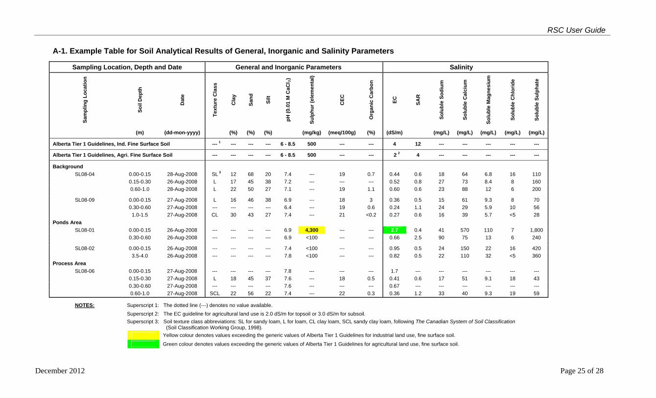
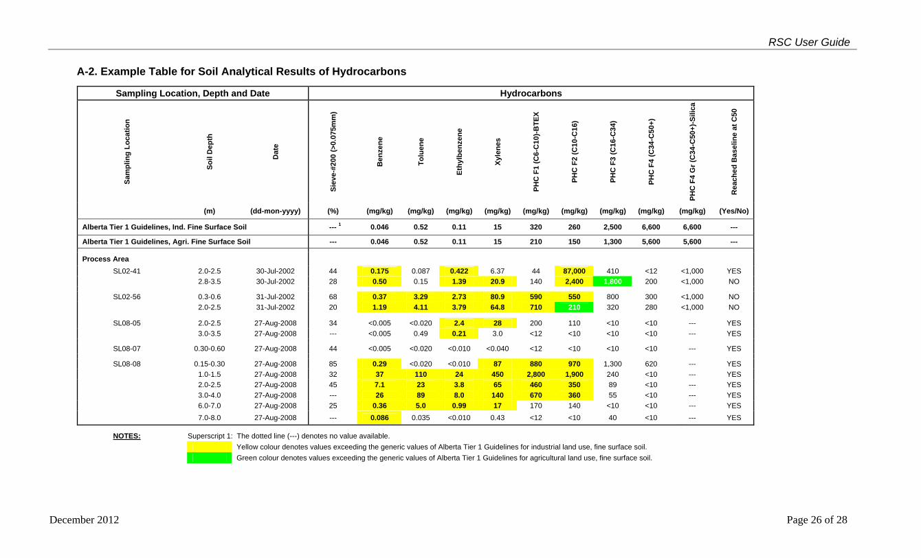
The Record of Site Condition form, Section 6.3 requires submission of analytical summary tables for all COPCs that were subject of the investigation. Summary tables should be in a consistent, easy to understand format and must include the following information:
Tier 1 guideline values from tables in the Alberta Tier 1 guidelines; where multiple land uses are used or the end land use differs from the current land use,
the most conservative Tier 1 value must be included in the table; analytical results for all sampling locations; sampling locations must be named with an identifier that will allow for cross reference to
the appropriate environmental site assessment report. Use of an identifier that references the facility or spill location is recommended;
location, depth and date that the sample was taken must be reported in a manner that can be cross referenced to the appropriate site plans and borehole logs in the environmental site assessment report;
report minimum detection limits where the COPC was not detected; values greater than the applicable Alberta Tier 1 guideline values for current and end land
use must be highlighted; and where groundwater was analyzed as part of the environmental site assessment, summary
tables for the groundwater assessment must also be included.
Tables should reflect the status of the site at the time of filing the Record of Site Condition. Use the following as guidance to complete the summary tables:
if this is the first Record of Site Condition being filed for the site, you will need to include any historical information from previous reports that provide an overall summary of all site analytical information;
if this is the first environmental site assessment that was conducted at the site or where the Record of Site Condition is updating previously filed information, include only the new information in the summary tables; or
if this is being filed for a remediated site, only include historical information that still reflects the current site condition. For instance, if contaminated soil was removed as part of remediation, do not include historical information from within the remediated area.
The following example tables provide the standardized table format for soil assessments. The tables are provided as examples only. The exact format will depend on site-specific requirements. However, tables must be easy to read, interpret, and cross-reference with the complete reports.
December 2012 Page 24 of 28
RSC User Guide
December 2012 Page 25 of 28
A-1. Example Table for Soil Analytical Results of General, Inorganic and Salinity Parameters
Sampling Location, Depth and Date General and Inorganic Parameters Salinity
Sam
pli
ng
Lo
cati
on
So
il D
epth
Dat
e
Tex
ture
Cla
ss
Cla
y
San
d
Silt
pH
(0.
01 M
Ca
Cl 2
)
Su
lph
ur
(ele
me
nta
l)
CE
C
Org
an
ic C
arb
on
EC
SA
R
So
lub
le S
od
ium
So
lub
le C
alci
um
So
lub
le M
agn
esiu
m
So
lub
le C
hlo
rid
e
So
lub
le S
ulp
hat
e
(m) (dd-mon-yyyy) (%) (%) (%) (mg/kg) (meq/100g) (%) (dS/m) (mg/L) (mg/L) (mg/L) (mg/L) (mg/L)
Alberta Tier 1 Guidelines, Ind. Fine Surface Soil --- 1 --- --- --- 6 - 8.5 500 --- --- 4 12 --- --- --- --- ---
Alberta Tier 1 Guidelines, Agri. Fine Surface Soil --- --- --- --- 6 - 8.5 500 --- --- 2 2 4 --- --- --- --- ---
Background
SL08-04 0.00-0.15 28-Aug-2008 SL 3 12 68 20 7.4 --- 19 0.7 0.44 0.6 18 64 6.8 16 110
0.15-0.30 26-Aug-2008 L 17 45 38 7.2 --- --- --- 0.52 0.8 27 73 8.4 8 160
0.60-1.0 28-Aug-2008 L 22 50 27 7.1 --- 19 1.1 0.60 0.6 23 88 12 6 200
SL08-09 0.00-0.15 27-Aug-2008 L 16 46 38 6.9 --- 18 3 0.36 0.5 15 61 9.3 8 70
0.30-0.60 27-Aug-2008 --- --- --- --- 6.4 --- 19 0.6 0.24 1.1 24 29 5.9 10 56
1.0-1.5 27-Aug-2008 CL 30 43 27 7.4 --- 21 <0.2 0.27 0.6 16 39 5.7 <5 28
Ponds Area
SL08-01 0.00-0.15 26-Aug-2008 --- --- --- --- 6.9 4,300 --- --- 2.7 0.4 41 570 110 7 1,800
0.30-0.60 26-Aug-2008 --- --- --- --- 6.9 <100 --- --- 0.66 2.5 90 75 13 6 240
SL08-02 0.00-0.15 26-Aug-2008 --- --- --- --- 7.4 <100 --- --- 0.95 0.5 24 150 22 16 420
3.5-4.0 26-Aug-2008 --- --- --- --- 7.8 <100 --- --- 0.82 0.5 22 110 32 <5 360
Process Area
SL08-06 0.00-0.15 27-Aug-2008 --- --- --- --- 7.8 --- --- --- 1.7 --- --- --- --- --- ---
0.15-0.30 27-Aug-2008 L 18 45 37 7.6 --- 18 0.5 0.41 0.6 17 51 9.1 18 43
0.30-0.60 27-Aug-2008 --- --- --- --- 7.6 --- --- --- 0.67 --- --- --- --- --- ---
0.60-1.0 27-Aug-2008 SCL 22 56 22 7.4 --- 22 0.3 0.36 1.2 33 40 9.3 19 59
NOTES: Superscript 1: The dotted line (---) denotes no value available.
Superscript 2: The EC guideline for agricultural land use is 2.0 dS/m for topsoil or 3.0 dS/m for subsoil.
Superscript 3: Soil texture class abbreviations: SL for sandy loam, L for loam, CL clay loam, SCL sandy clay loam, following The Canadian System of Soil Classification
(Soil Classification Working Group, 1998).
Yellow colour denotes values exceeding the generic values of Alberta Tier 1 Guidelines for industrial land use, fine surface soil.
Green colour denotes values exceeding the generic values of Alberta Tier 1 Guidelines for agricultural land use, fine surface soil.
RSC User Guide
December 2012 Page 26 of 28
A-2. Example Table for Soil Analytical Results of Hydrocarbons
Sampling Location, Depth and Date Hydrocarbons
Sam
pli
ng
Lo
cati
on
So
il D
epth
Dat
e
Sie
ve-#
200
(>0.
075m
m)
Ben
zen
e
To
luen
e
Eth
ylb
enze
ne
Xyl
enes
PH
C F
1 (C
6-C
10)-
BT
EX
PH
C F
2 (C
10-C
16)
PH
C F
3 (C
16-C
34)
PH
C F
4 (C
34-C
50+
)
PH
C F
4 G
r (C
34-C
50+
)-S
ilica
Rea
che
d B
asel
ine
at C
50
(m) (dd-mon-yyyy) (%) (mg/kg) (mg/kg) (mg/kg) (mg/kg) (mg/kg) (mg/kg) (mg/kg) (mg/kg) (mg/kg) (Yes/No)
Alberta Tier 1 Guidelines, Ind. Fine Surface Soil --- 1 0.046 0.52 0.11 15 320 260 2,500 6,600 6,600 ---
Alberta Tier 1 Guidelines, Agri. Fine Surface Soil --- 0.046 0.52 0.11 15 210 150 1,300 5,600 5,600 ---
Process Area
SL02-41 2.0-2.5 30-Jul-2002 44 0.175 0.087 0.422 6.37 44 87,000 410 <12 <1,000 YES
2.8-3.5 30-Jul-2002 28 0.50 0.15 1.39 20.9 140 2,400 1,800 200 <1,000 NO
SL02-56 0.3-0.6 31-Jul-2002 68 0.37 3.29 2.73 80.9 590 550 800 300 <1,000 NO
2.0-2.5 31-Jul-2002 20 1.19 4.11 3.79 64.8 710 210 320 280 <1,000 NO
SL08-05 2.0-2.5 27-Aug-2008 34 <0.005 <0.020 2.4 28 200 110 <10 <10 --- YES
3.0-3.5 27-Aug-2008 --- <0.005 0.49 0.21 3.0 <12 <10 <10 <10 --- YES
SL08-07 0.30-0.60 27-Aug-2008 44 <0.005 <0.020 <0.010 <0.040 <12 <10 <10 <10 --- YES
SL08-08 0.15-0.30 27-Aug-2008 85 0.29 <0.020 <0.010 87 880 970 1,300 620 --- YES
1.0-1.5 27-Aug-2008 32 37 110 24 450 2,800 1,900 240 <10 --- YES
2.0-2.5 27-Aug-2008 45 7.1 23 3.8 65 460 350 89 <10 --- YES
3.0-4.0 27-Aug-2008 --- 26 89 8.0 140 670 360 55 <10 --- YES
6.0-7.0 27-Aug-2008 25 0.36 5.0 0.99 17 170 140 <10 <10 --- YES
7.0-8.0 27-Aug-2008 --- 0.086 0.035 <0.010 0.43 <12 <10 40 <10 --- YES
NOTES: Superscript 1: The dotted line (---) denotes no value available.
Yellow colour denotes values exceeding the generic values of Alberta Tier 1 Guidelines for industrial land use, fine surface soil.
Green colour denotes values exceeding the generic values of Alberta Tier 1 Guidelines for agricultural land use, fine surface soil.
RSC User Guide
December 2012 Page 27 of 28
A-3. Example Table for Soil Analytical Results of Polycyclic Aromatic Hydrocarbons (PAHs)
Sampling Location, Depth and Date Carcinogenic PAHs Other PAHs S
amp
lin
g L
oca
tio
n
So
il D
epth
Dat
e
Ben
zo(a
)an
thra
cen
e
Ben
zo(b
+j)
flu
ora
nth
ene
Ben
zo(k
)flu
ora
nth
ene
Ben
zo(g
,h,i
)per
ylen
e
Ben
zo(a
)pyr
ene
Ch
ryse
ne
Dib
enzo
(a,h
)an
thra
cen
e
Ind
en
o(1
,2,3
-cd
)pyr
ene
Ace
na
pth
ene
Ace
na
ph
thyl
en
e
An
thra
cen
e
Flu
ora
nth
ene
Flu
ore
ne
Nap
hth
alen
e
Ph
ena
nth
ren
e
Pyr
ene
(m) (dd-mon-yyyy) (mg/kg) (mg/kg) (mg/kg) (mg/kg) (mg/kg) (mg/kg) (mg/kg) (mg/kg) (mg/kg) (mg/kg) (mg/kg) (mg/kg) (mg/kg) (mg/kg) (mg/kg) (mg/kg)
Alberta Tier 1 Guidelines, Ind. Fine Surface Soil 0.070 --- 1 --- --- 0.70 --- 7.4 --- 0.32 5.0 0.0046 0.032 0.29 0.016 0.051 0.034
Alberta Tier 1 Guidelines, Agri. Fine Surface Soil 0.070 6.2 6.2 --- 0.60 6.2 7.4 --- 0.32 5.0 0.0046 0.032 0.29 0.016 0.051 0.034
Background
SL08-04 0.15-0.30 26-Aug-2008 <0.0050 <0.0050 <0.0050 <0.0050 <0.0050 <0.0050 <0.0050 <0.0050 <0.0050 <0.0050 <0.0050 <0.0050 <0.0050 <0.0050 <0.0050 <0.0050
Storage Area
SL08-03 0.00-0.15 26-Aug-2008 <0.0050 <0.0050 <0.0050 <0.0050 <0.0050 <0.0050 <0.0050 <0.0050 <0.0050 <0.0050 <0.0050 0.0065 <0.0050 0.0067 0.013 <0.0050
NOTES: Superscript 1: The dotted line (---) denotes no value available.
Light blue colour denotes analytical detection limit is higher than the guideline value.
RSC User Guide
December 2012 Page 28 of 28
A-4. Example Table for Soil Analytical Results of Trace Elements
Sampling Location, Depth and Date Trace Element S
amp
lin
g L
oca
tio
n
So
il D
epth
Dat
e
Ars
enic
(in
org
an
ic)
Bar
ium
(n
on
-ba
rite
)
Ber
ylliu
m
Bo
ron
(h
ot
wa
ter
solu
ble
)
Cad
miu
m
Ch
rom
ium
(h
exav
alen
t)
Ch
rom
ium
(to
tal)
Co
bal
t
Co
pp
er
Lea
d
Mer
cury
(in
org
an
ic)
Mo
lyb
den
um
Nic
kel
Sel
eniu
m
Th
alli
um
Van
adiu
m
Zin
c
(m) (dd-mon-yyyy) (mg/kg) (mg/kg) (mg/kg) (mg/kg) (mg/kg) (mg/kg) (mg/kg) (mg/kg) (mg/kg) (mg/kg) (mg/kg) (mg/kg) (mg/kg) (mg/kg) (mg/kg) (mg/kg) (mg/kg)
Alberta Tier 1 Guidelines, Ind. Fine Surface Soil 26 2,000 8 2 22 1.4 87 300 91 600 50 40 50 2.9 1 130 360
Alberta Tier 1 Guidelines, Agri. Fine Surface Soil 17 750 5 2 1.4 0.4 64 20 63 70 6.6 4 50 1 1 130 200
Background
SL02-10 0.00-0.15 30-Jul-2002 5.6 143 0.302 0.76 0.16 --- 1 14.7 7.91 9.02 9.8 <0.01 0.38 18.2 0.48 <0.4 19.3 45.1
0.15-0.30 30-Jul-2002 6.9 131 0.407 0.22 0.08 --- 21.6 8.82 12.1 10.6 <0.01 0.26 21.8 0.34 <0.4 24.4 50.2
0.30-0.60 30-Jul-2002 7.4 126 0.428 0.41 0.07 --- 18.5 8.36 12.8 10.6 <0.01 0.23 22.9 0.53 <0.4 21.5 49.3
0.60-1.0 30-Jul-2002 <1.0 <0.02 <0.05 0.30 <0.05 --- <0.08 <0.07 <0.1 <0.2 <0.01 <0.1 <0.1 <0.3 <0.4 0.0 <0.05
SL02-11 0.30-0.60 30-Jul-2002 4.7 135 0.82 1.08 0.16 --- 23.6 6.92 10.1 7.70 0.061 0.38 19.0 <1 0.14 23.3 41.3
1.0-1.5 30-Jul-2002 5.6 141 0.75 0.30 0.13 --- 22.5 7.29 11.3 6.89 0.055 0.47 21.5 <1 0.16 20.1 38.1
1.5-2.0 30-Jul-2002 5.3 199 0.78 0.17 0.29 --- 19.0 7.25 11.2 6.73 0.054 0.53 20.3 <1 0.31 20.2 36.9
Process Area
SL02-38 0.6-1.0 30-Jul-2002 6.3 142 0.52 2.4 0.17 0.02 25.0 8.69 19.4 7.66 0.041 0.45 25.7 <1 0.13 34.2 56.5
1.5-1.8 30-Jul-2002 8.9 263 0.54 0.17 0.18 <0.01 31.7 10.2 20.7 7.55 0.040 0.49 31.7 <1 0.13 35.3 63.0
SL02-39 0.30-0.60 30-Jul-2002 6.1 168 0.44 0.90 0.21 0.01 29.6 6.89 18.5 13.2 0.047 0.97 22.7 <1 0.15 32.5 58.6
1.0-1.5 30-Jul-2002 7.4 278 0.50 0.12 0.22 0.01 29.2 9.76 19.1 7.34 0.050 0.65 29.8 <1 0.14 35.3 63.0
SL08-05 2.0-2.5 27-Aug-2008 --- --- --- 0.90 --- <0.15 --- --- --- --- --- --- --- --- --- --- ---
SL08-08 1.0-1.5 27-Aug-2008 --- --- --- 0.10 --- <0.15 --- --- --- --- --- --- --- --- --- --- ---
NOTES: Superscript 1: The dotted line (---) denotes no value available.
Yellow colour denotes values exceeding the generic values of Alberta Tier 1 Guidelines for industrial and agricultural land uses, fine surface soil.