records of ancient human-environmental … of ancient human-environmental interaction from mayan...
TRANSCRIPT

FAMSI © 2005: D.E. Cook
Records of Ancient Human-Environmental Interaction from Mayan Southern Petén, Guatemala Part 1: A 1300-year record of human activity and climate change from Cancuén
Research Year: 2004 Culture: Maya Chronology: Classic Location: Southern Petén, Guatemala Site: Cancuén
Table of Contents
Introduction Methods Results
Introduction Radiocarbon dating Detailed stratigraphy Chemical properties of the sediments
Archaeological and Environmental History at Cancuén c. 2.70 (?)–2.25 m: Before Cancuén 2.25–2.10 m: Early Cancuén c. 2.10–1.90 m: Fire at Cancuén 1.90–1.50 m: The last decades of Cancuén 1.50–0.00 m: Post-Cancuén, the last 1000 years
Conclusions Acknowledgements List of Figures Sources Cited
2
Appendix 1. Sediment descriptions Appendix 2. Accuracy of chemical analyses: Results of separate analyses of duplicate field samples
Submitted 10/18/2005 by:
Duncan E. Cook School of Geosciences The University of Sydney Sydney, NSW Australia [email protected]
3
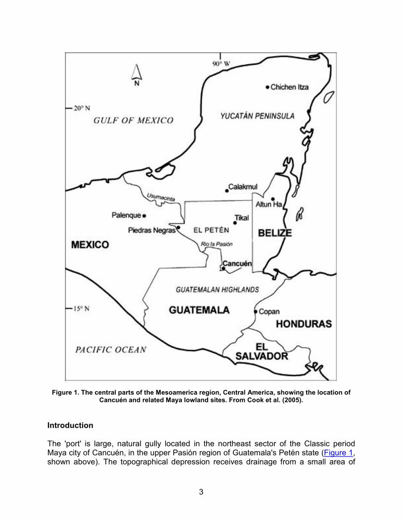
Figure 1. The central parts of the Mesoamerica region, Central America, showing the location of
Cancuén and related Maya lowland sites. From Cook et al. (2005).
Introduction
The 'port' is large, natural gully located in the northeast sector of the Classic period Maya city of Cancuén, in the upper Pasión region of Guatemala's Petén state (Figure 1, shown above). The topographical depression receives drainage from a small area of
4
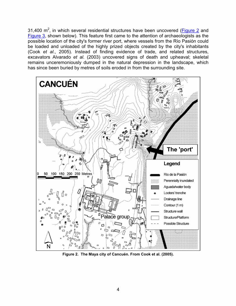
31,400 m2, in which several residential structures have been uncovered (Figure 2 and Figure 3, shown below). This feature first came to the attention of archaeologists as the possible location of the city's former river port, where vessels from the Río Pasión could be loaded and unloaded of the highly prized objects created by the city's inhabitants (Cook et al., 2005). Instead of finding evidence of trade, and related structures, excavators Alvarado et al. (2003) uncovered signs of death and upheaval; skeletal remains unceremoniously dumped in the natural depression in the landscape, which has since been buried by metres of soils eroded in from the surrounding site.
Figure 2. The Maya city of Cancuén. From Cook et al. (2005).

5
In 2004, a detailed excavation of the 'port' area was undertaken by researchers from Vanderbilt University (excavation CAN38-49-14), in an attempt to understand the scale of human remains in these sediments, the spatial distribution of them, and to try and understand how a mass burial came to be there. As one of only a few topographical depressions at Cancuén, this location offered a unique opportunity to examine human-environmental interactions during the entire history of a Mayan city. As the gully has infilled through time, soils eroded from the surrounding catchment have been deposited sequentially, and preserved. These sediments have the potential to preserve parallel records of archaeological and palaeoenvironmental history, allowing the rare opportunity to develop a scientific record of how the Classic period Maya and their environment had co-evolved during the Classic period in this region. As the sediments deposited in the gully span both pre- and post-Maya civilization, both the beginning and end of human activity at Cancuén was potentially recorded. Detailed analysis of these sediments then could provide answers to questions of the age of the city's construction, abandonment, and the environmental conditions that prevailed in the lowland southern Petén site throughout this period.
Figure 3. The 'port' area of Cancuén. The immediate catchment of the gully is marked in red, the
excavations in the central part of the gully are marked with a circular symbol.
6
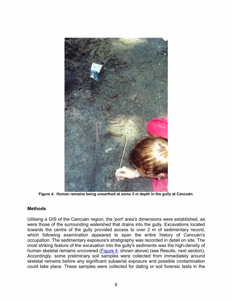
Figure 4. Human remains being unearthed at some 2 m depth in the gully at Cancuén.
Methods
Utilising a GIS of the Cancuén region, the 'port' area's dimensions were established, as were those of the surrounding watershed that drains into the gully. Excavations located towards the centre of the gully provided access to over 2 m of sedimentary record, which following examination appeared to span the entire history of Cancuén's occupation. The sedimentary exposure's stratigraphy was recorded in detail on site. The most striking feature of the excavation into the gully's sediments was the high-density of human skeletal remains uncovered (Figure 4, shown above) (see Results, next section). Accordingly, some preliminary soil samples were collected from immediately around skeletal remains before any significant subaerial exposure and possible contamination could take place. These samples were collected for dating or soil forensic tests in the

7
future (second part of this report) that may provide information on the circumstances of these people's deaths.
Figure 5. Detail of the eastern wall of the excavated pit in the 'port' area of Cancuén. The
stratigraphy presented in this report is based on the eastern wall of this excavation. Sediment samples were also collected from this wall. Human skeletal remains towards the base of unit IV
can be observed in the bottom of the photograph.
Sediment samples of approximately 10 g mass were collected down the sedimentary sequence at 100 mm intervals from an exposed wall of a 4 x 4 m pit (Figure 5, shown

8
above), while additional spot samples were collected when unique features were identified. All samples were collected with nylon tools where possible to avoid metalliferous contamination. Duplicate samples were collected every ten samples. An additional excavation pit located at the eastern edge of the gully, dug into the levee bank of the Pasión, was also sampled in this manner. Wherever possible, organic or charred remains in the sediments were collected to provide material for radiocarbon dating. In particular, an extensive and continuous layer of burnt sediments (including ceramic fragments and plant matter) that underlay those sediments containing the greatest number of skeletal remains was sampled with extreme care.
Excavations undertaken in the grand palace at Cancuén (Figure 2) revealed what was likely to represent a termination event in the structure, characterised by an extensive layer of charcoal several metres in length, and upwards of 10 mm depth in parts. Architecturally, this layer was considered to date from the latter period of Cancuén's history. A large volume of this material was sampled for radiocarbon dating by radiometric methods. As all charred materials sampled for dating had been burnt in situ, the problem of older material being transported into stratigraphically younger sediments (Blong and Gillespie, 1978), and thus generating erroneously old ages, was avoided. All samples collected from Cancuén were sealed in plastic and returned to Australia for laboratory analysis.
For each sample, Munsell colour, particle size information, and detailed descriptions were recorded. Those samples (n=6) which potentially were suitable for radiocarbon dating were examined microscopically to ensure no post-sampling growth of bacteria or fungus had occurred. On this basis, two samples were rejected from the study. The remaining four samples displayed no evidence of post-sampling contamination, which may severely distort radiocarbon measurements. Both conventional (radiometric, n=1) and AMS (n=3) radiocarbon dates were undertaken by Beta Analytic Inc. (U.S.A.). One sample, an animal femur bone from the base of the eastern pit in the gully failed to produce sufficient carbon after pre-treatment, and was therefore unable to provide an age estimate (Ron Hatfield, Deputy Director of Beta Analytic Inc., personal communication, 2005).
Each sediment sample was sub-sampled using plastic tools, and sub-samples prepared for chemical analysis following a modification of the procedure of Cook et al. (2005), using 10 ml of concentrated 9:1 HNO3:HCl acids and test tube digestion at 100ºC for four hours. The concentration of 16 elements was determined simultaneously for each sample using Inductively Coupled Plasma-Atomic Emission Spectroscopy (ICP-AES).
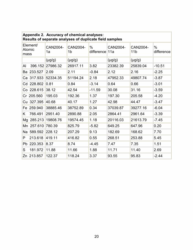
Estimates of analytical precision and accuracy for individual samples, and for the procedure were made based on the methods outlined in Cook et al., (2005); rapid, triplicate measurements of every 10th sample, repeat digestion and analysis of every 10th sample collected, and the analysis of four standards of known concentrations in sequence with the Cancuén samples. In addition, procedural blanks were prepared and analysed to determine the concentration of each element as a product of the reagents used and general procedural contamination.
9
Results
Introduction
As the radiocarbon dating of the stratigraphy of the eastern edge of the gully failed, no timescale is available at present to date these sediments. Without sediment ages, very little reliable information on Cancuén's history can be gained. As such, they will not be considered any further in this report.
Radiocarbon dating
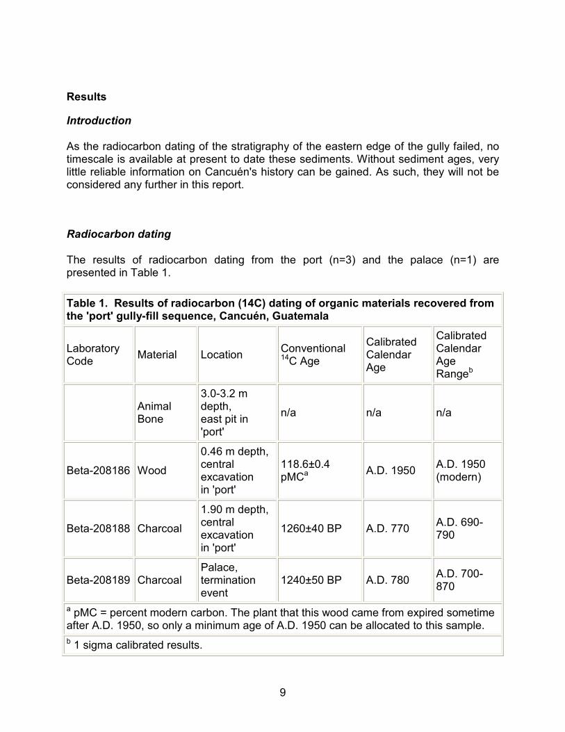
The results of radiocarbon dating from the port (n=3) and the palace (n=1) are presented in Table 1.
Table 1. Results of radiocarbon (14C) dating of organic materials recovered from the 'port' gully-fill sequence, Cancuén, Guatemala
Laboratory Code
Material Location Conventional 14C Age
Calibrated Calendar Age
Calibrated Calendar Age Rangeb
Animal Bone
3.0-3.2 m depth, east pit in 'port'
n/a n/a n/a
Beta-208186 Wood
0.46 m depth, central excavation in 'port'
118.6±0.4 pMCa
A.D. 1950 A.D. 1950 (modern)
Beta-208188 Charcoal
1.90 m depth, central excavation in 'port'
1260±40 BP A.D. 770 A.D. 690-790
Beta-208189 Charcoal Palace, termination event
1240±50 BP A.D. 780 A.D. 700-870
a pMC = percent modern carbon. The plant that this wood came from expired sometime after A.D. 1950, so only a minimum age of A.D. 1950 can be allocated to this sample.
b 1 sigma calibrated results.

10
Detailed stratigraphy
The stratigraphies of the sediments in the 'port' are presented in Figure 6, shown below, while full detail descriptions of them are detailed in Appendix 1. Soil colours were determined using a Munsell soil colour chart on undried samples.
Figure 6. The physical and chemical stratigraphy and chronology of the 'port' gully-fill sequence from Cancuén, Guatemala. Stratigraphic unit numbers (I–VIII) refer to units which are described in
full in Appendix 1.
Chemical properties of the sediments
Analytical accuracy was typically better than 95%. Accuracy in determining sodium, magnesium and aluminium was better than 90%. As these elements are not considered in this report, the lower accuracy is not of great concern. Although a range of interesting patterns are exhibited in the 20 elements analysed for in the study, the concentrations of calcium, phosphorus, potassium and lead have provided the most useful inferences on Cancuén's environmental history (Figure 6). Due to space limitations, further discussion will focus on these elements alone.

11
Archaeological and Environmental History at Cancuén
c. 2.70 (?)–2.25 m: Before Cancuén
The lowermost sediments in this sequence, devoid of any cultural debris, date from the millennia before Cancuén's beginnings in the 17th century. Sediment chemistry is dramatically different from overlying strata, with phosphorus and calcium concentrations being very low. Plant matter content is low, although this differs very little from overlying sediments. Although the pre-Cancuén sediments have not been sampled extensively, the low plant matter, and lack of any flood deposits from the nearby Pasión, suggests that relatively dry conditions were probably operating at least shortly before the site's beginnings.
2.25–2.10 m: Early Cancuén
A well-defined layer of sediments from c. 2.25 to 2.10 m depth represents an earlier phase of Cancuén's history, estimated to finish sometime in the late 600s A.D., based on 14C dating of overlying sediments. Dating of the beginning of this layer may have provided information on when human activity first began in this sector of the city. Unfortunately, no suitable material was recovered from this depth for dating. There is no evidence of human activity below c. 2.10 m depth, below which only sterile buried soils of up to c. 0.5 m thickness are found. No human remains have been uncovered in this stratum to date. A significant amount of ceramic fragments were imbedded in this layer, as were eroded fragments of CaCO3 material from the upslope structures. These ceramics are presently being analysed by Vanderbilt University researchers for information on their provenance and chronological implications. Chemical and physical indicators show that no major shifts in climate during this time are recorded at Cancuén; no evidence of flooding, nor increases in organic productivity that would accompany wetter conditions.
c. 2.10–1.90 m: Fire at Cancuén
This well-constrained stratum is entirely composed predominantly of charred material; sediments, organic matter, and some ceramic fragments. The 100 to 200 mm thick band is thought to span the entire gully at this depth, recording a large-scale fire event at the site. Although a series of smaller fires instead may have been responsible, the large fragments of charcoal, up to 100 mm in length, which often span the entire layer, suggest that a single conflagration may have inflicted all of the damage. AMS 14C dating of this layer places the date of the fire at A.D. 770, occurring sometime toward the end of Cancuén's history between A.D. 690 and 790 (Table 1). Stratigraphically, the fire
12
event would have taken place towards then end of the 0.2 m of deposition; that is, the sediments from 2.10–1.90 m were deposited before the fire.
It is possible that both the fire event in the 'port' area and the termination event recorded in the palace are contemporaneous. Although the age range of each date overlaps, the events responsible for each could be up 100 years apart. However, some support for their close connection comes from the 14C chemistry of both samples, which is similar. In any case, both events date from the latter period of Cancuén's history, the 700s A.D. It is thought that the dated termination event from the palace may coincide with the ascent of Cancuén's final King, Kan Maax.
1.90–1.50 m: The last decades of Cancuén
The sediments from 1.90 to 1.50 m depth in the 'port' record the crucial last decades of Cancuén's history. A detailed report on the numerous human remains found in these sediments has been produced by Berryman et al. (2004), and only a brief summary is produced here. Up to 11 human skeletons, partially disarticulated, have been recovered from the stratum immediately above the charred layer. Associated with these were elaborate jade and jaguar-tooth jewellery, suggesting these were the remains of elite inhabitants of the city. A great body of forensic evidence suggests a massacre had occurred; the bodies had been crudely defleshed, some torn apart, and dumped in the gully. More, probably non-elite, human remains were also found towards the top of this stratum. The spatial pattern of these remains, and the level of articulation of the skeletons form the basin of the argument of these bodies having been left in the gully, rather than having eroded in from upslope burials through time. Soil forensic tests, presently being undertaken, will hopefully provide more information on this unique phase of Cancuén's history.
The latest date for occupation at Cancuén is May 12th, A.D. 800, based on the epigraphic record. Results from the site's ceramic chronology place the end of Cancuén about the same time (end of the Tepeu 2 and beginning of the Tepeu 3 ceramic phase). All available evidence suggests that Cancuén was rapidly abandoned after this time. No record of the massacre is preserved in any other archaeological source to date, including the epigraphic record. It is not inconceivable then, that the massacre probably post-dates May 12th, A.D. 800. During these final decades, the 'port' area of Cancuén was very active. The geochemical record suggests significant numbers of people and possibly animals were still active in the immediate area during these final years. High phosphorus levels, most likely the product of human and/or animal waste, record substantial human activity, while additional calcium being eroded into the basin gave rise to the highest levels recorded during the site's history, suggesting significant activity upslope of the gully in the final decades. The sediments during this phase, the early 800s A.D., are dominated by significant hillslope erosion, with no visual evidence of flooding from the nearby Pasión River. With some 0.4 m of sediment deposited between the fire event and the site's end, a crude estimate places eroded soil material being deposited as rapidly as 40 mm a year. Plant organic matter is also low during this
13
period. These separate lines of evidence suggest relatively dryer climatic conditions prevailed during the 700-800s A.D.
1.50–0.00 m: Post-Cancuén, the last 1000 years
A well-defined boundary separates those sediments above c. 1.50 m from those below this depth. The sediments above this depth are considered to date from after Cancuén's abandonment. The most convincing evidence of this comes from the geochemical and archaeological record. Phosphorus, a strong indicator of human activity, decreases dramatically by nine times above 1.50 m. In fact, the sediment chemistry above this depth is very similar to that of the sterile soils of >2.3 m depth. Although some ceramic and bones are found in the top 1.5 m of sediment (mainly towards the base of the unit), their occurrence is rarer than in the sediments below. Typically, only individual bones or fragments are found above 1.50 m, and it is thought that these, in contrast to the in situ remains found below, have been eroded into the port over time from shallow burials above. The rapid end of Cancuén, in what increasingly seems to be tumultuous conditions, leads to rapid, shallow burials taking place on patio floors surrounding the 'port' area (Alvarado et al., 2003). Ceramic remains in these sediments are in poor condition, with rounded edges, again suggesting transportation from the surrounding former occupation area's post-abandonment.
The top c. 1.50 m of sediments in the 'port' records the environmental history of over 1000 years after Cancuén. What information is preserved about environmental conditions from the mid 800s to today? The sharp boundary observed at c. 1.50 m depth is suggestive of a discontinuity in sedimentation. If dry conditions continued past the 800s A.D., then without human activity in the area to generate erosion, sedimentation in the gully would have been significantly reduced, and possibly halted. Climate records from the nearby northern Petén suggest that extremely dry conditions prevailed in the Terminal Classic, between A.D. 800 and 900 (Rosenmeier et al., 2002). Such conditions eventually shifted at Cancuén, and hillslope erosion recommenced, bringing in soil and cultural debris from the surrounding area. Based on palaeoclimate records from the Yucatán, the driest period of the last 10,000 years roughly corresponds to the Late Classic period, leading to causative associations with the Maya 'collapse' (Metcalfe et al., 2000). Wetter conditions at least in the Yucatán appear to have recommenced shortly after this time.
14
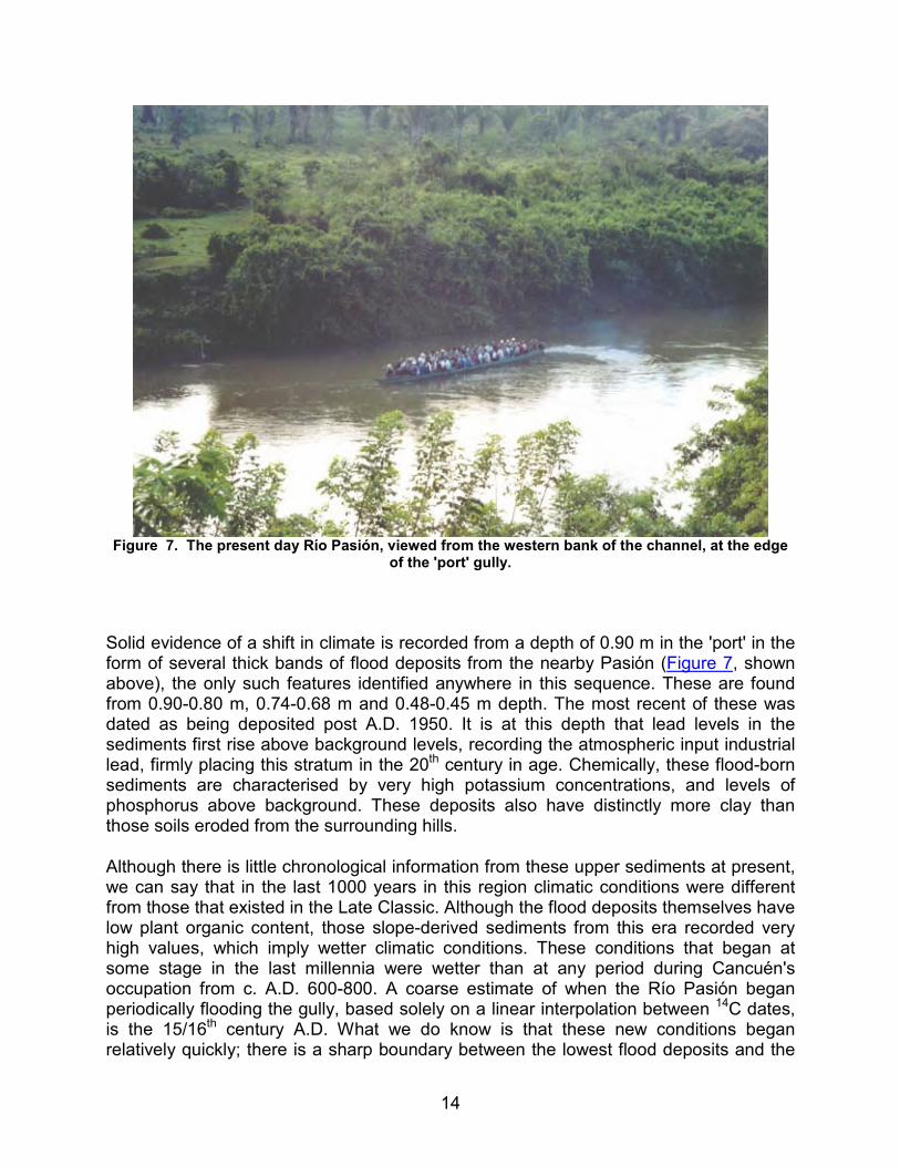
Figure 7. The present day Río Pasión, viewed from the western bank of the channel, at the edge
of the 'port' gully.
Solid evidence of a shift in climate is recorded from a depth of 0.90 m in the 'port' in the form of several thick bands of flood deposits from the nearby Pasión (Figure 7, shown above), the only such features identified anywhere in this sequence. These are found from 0.90-0.80 m, 0.74-0.68 m and 0.48-0.45 m depth. The most recent of these was dated as being deposited post A.D. 1950. It is at this depth that lead levels in the sediments first rise above background levels, recording the atmospheric input industrial lead, firmly placing this stratum in the 20th century in age. Chemically, these flood-born sediments are characterised by very high potassium concentrations, and levels of phosphorus above background. These deposits also have distinctly more clay than those soils eroded from the surrounding hills.
Although there is little chronological information from these upper sediments at present, we can say that in the last 1000 years in this region climatic conditions were different from those that existed in the Late Classic. Although the flood deposits themselves have low plant organic content, those slope-derived sediments from this era recorded very high values, which imply wetter climatic conditions. These conditions that began at some stage in the last millennia were wetter than at any period during Cancuén's occupation from c. A.D. 600-800. A coarse estimate of when the Río Pasión began periodically flooding the gully, based solely on a linear interpolation between 14C dates, is the 15/16th century A.D. What we do know is that these new conditions began relatively quickly; there is a sharp boundary between the lowest flood deposits and the

15
underlying slope-derived sediments. Modern observations of the Pasión suggest that occasional over-bank flow into the 'port' area can occur. These flood deposits therefore may record the beginning of environmental conditions not too different to those at Cancuén today. More detailed palaeoenvironmental information for the millennia post-Cancuén cannot, at present, be identified due to the course chronological resolution. Future research on the dating of these sediments will aim to refine when these shifts in environmental conditions post-A.D. 800 took place.
Conclusions
A new sedimentary record from an infilling gully at Cancuén, in the Upper Pasión region of the Petén, Guatemala has preserved a dual history of environmental and archaeological change during the last 1300 years. Preliminary findings from this study suggest that relatively stable climatic conditions prevailed during the c. 200 year history of Maya Cancuén. There is some evidence that these centuries were significantly drier than present day climate. Towards the end of Cancuén in c. A.D. 800, a major fire took place, and although its ferocity is preserved in the gully sequence, it was probably not confined solely to this area, and may have damaged parts of the northeast of the city. Dating evidence suggests that this event may be contemporaneous with the final termination event in Cancuén's palace, and the rise of the city's last regime. Shortly afterwards, a massacre of up to 11 of Cancuén's elite, and then non-elite inhabitants occurred, with their remains being dumped (not buried) in the depression. Evidence from this sequence suggests that the final tumultuous years of Cancuén were also characterised by high rates of erosion and human activity in this part of the city.
A discontinuity in sedimentation, recorded soon after abandonment of the site, may reflect a peak in drought-like conditions operating in this region, which may coincide chronologically with the Maya Terminal Classic. At some stage in the last 1000 years, the onset of much wetter conditions began quite rapidly, and the nearby Pasión River began regularly flooding the small gully. The most recent of these flood deposits dates from the 20th century.
Acknowledgements
This research has been made possible due to the generous financial support of FAMSI, via a general research grant (grant number 03042). As an early career researcher from Australia, this grant allowed me a unique and exciting opportunity: to apply my knowledge of human-environmental interactions gained in Australasia to research questions in the Maya world, in conjunction with world-class multi-national archaeological teams. In particular, FAMSI provided the funds required for me to travel half-way around the globe to Guatemala, for several weeks travel and accommodation in the Petén region in Guatemala, for logistical costs of shipping and supplies, for sedimentological and chemical analyses of soil and sediment samples collected from

16
several sites in the southern Petén, and for essential radiometric and mass-spectrometric 14C dates.
This research initiative was first initiated by Dr. Ron Bishop from the Smithsonian Institution (U.S.A.) who supervised my research-fellowship at SCMRE in 2002/2003, and who made me aware of FAMSI's role in supporting Mesoamerican research. None of this research could have been possible without Dr. Bishop's ongoing support. Colleagues from Vanderbilt University provided access to exciting new sites in the southern Petén region surrounding Cancuén, as well as additional logistical support, assistance in the field and helpful discussions of ideas; Prof. Arthur Demarest, Mr. Brent Woodfill, Mr. Tomas Barrientos, Ms. Brigitte Kovacevich, Ms. Carrie-Anne Berryman and Ms. Anna Novotny. Detailed information used in this report on the skeletal remains recovered at Cancuén in the 'port' was provided by osteoarchaeologists Ms. Carrie-Anne Berryman and Ms. Anna Novotny.
List of Figures
Figure 1. The central parts of the Mesoamerica region, Central America, showing the location of Cancuén and related Maya lowland sites. From Cook et al. (2005).
Figure 2. The Maya city of Cancuén. From Cook et al. (2005).
Figure 3. The 'port' area of Cancuén. The immediate catchment of the gully is marked in red, the excavations in the central part of the gully are marked with a circular symbol.
Figure 4. Human remains being unearthed at some 2 m depth in the gully at Cancuén.
Figure 5. Detail of the eastern wall of the excavated pit in the 'port' area of Cancuén. The stratigraphy presented in this report is based on the eastern wall of this excavation. Sediment samples were also collected from this wall. Human skeletal remains towards the base of unit IV can be observed in the bottom of the photograph.
Figure 6. The physical and chemical stratigraphy and chronology of the 'port' gully-fill sequence from Cancuén, Guatemala. Stratigraphic unit numbers (I–VIII) refer to units which are described in full in Appendix 1.
Figure 7. The present day Río Pasión, viewed from the western bank of the channel, at the edge of the 'port' gully.

17
Sources Cited
Alvarado, C., J. Bauer, and K. Pereira
2003 "Investigaciones en el Puerto Principal de Cancuén." In Proyecto Arqueológico Cancuén, Informe Temporada 2002, edited by A. Demarest, T. Barrientos, B. Kovacevich, M. Callaghan, and L. Ruin, pp. 207-222. Instituto de Antropología e Historia, Guatemala, Department of Anthropology, Vanderbilt University, Nashville, TN.
Beach, T., N. Dunning, S. Luzzadder-Beach, D.E. Cook, and J. Lohse
in press Ancient Maya impacts on soils and erosion. Catena.
Berryman, C.A., A. Novotny, and K. Demarest
2004 "Operation 38 and 25D Excavations: Investigating the Origins of Human Remains found in the "Port"." In Proyecto Arqueológico Cancuén, Informe Temporada 2004, edited by A. Demarest and T. Barrientos. Instituto de Antropología e Historia, Guatemala, Department of Anthropology, Vanderbilt University, Nashville, TN.
Blong, R.J., and R. Gillespie
1978 "Fluvially transported charcoal gives erroneous 14C ages for recent deposits." In Nature 271, 739-741.
Cook, D.E., B. Kovacevich, T. Beach, and R. Bishop
2005 "Deciphering the inorganic chemical record of ancient human activity using ICP-MS: a reconnaissance study of Late Classic soil floors at Cancuén, Guatemala." In Journal of Archaeological Science.
Metcalfe, S.E., S.L. O'Hara, M. Caballero, and S.J. Davies
2002 "Records of Late Pleistocene-Holocene climatic change in México–a review." In Quaternary Science Reviews 19, 699-721.
Rosenmeier, M.F., D.A. Hodell, M. Brenner, J.H. Curtis, and T.P. Guilderson
2002 "A 4000-Year Lacustrine Record of Environmental Change in the Southern Maya Lowlands, Petén, Guatemala." In Quaternary Research 57, 183-190.
18
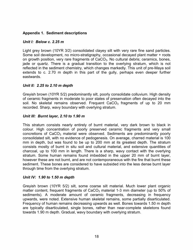
Appendix 1. Sediment descriptions
Unit I: Below c. 2.25 m
Light grey brown (10YR 3/2) consolidated clayey silt with very rare fine sand particles. Some soil development, no micro-stratigraphy, occasional decayed plant matter + roots on growth position, very rare fragments of CaCO3. No cultural debris; ceramics, bones, jade or quartz. There is a gradual transition to the overlying stratum, which is not reflected in the sediment chemistry, which changes markedly. This unit of pre-Maya soil extends to c. 2.70 m depth in this part of the gully, perhaps even deeper further eastwards.
Unit II: 2.25 to 2.10 m depth
Greyish brown (10YR 5/2) predominantly silt, poorly consolidate colluvium. High density of ceramic fragments in moderate to poor states of preservation often decayed into the soil. No skeletal remains observed. Frequent CaCO3 fragments of up to 20 mm recorded. Sharp, wavy boundary with overlying stratum.
Unit III: Burnt layer, 2.10 to 1.90 m
This stratum consists nearly entirely of burnt material, very dark brown to black in colour. High concentration of poorly preserved ceramic fragments and very small concretions of CaCO3 material were observed. Sediments are predominantly poorly consolidated silt, with no evidence of pedogenesis. On average, charred material is 100 mm in depth, but was found to be up to 200 mm at its greatest depth. The stratum consists mostly of burnt in situ soil and cultural material, and extensive quantities of charcoal, up to 100 mm in length. There is a sharp, wavy contact with the overlying stratum. Some human remains found imbedded in the upper 20 mm of burnt layer, however these are not burnt, and are not contemporaneous with the fire that burnt these sediment. These bones are considered to have subsided into the less dense burnt layer through time from the overlying stratum.
Unit IV: 1.90 to 1.50 m depth
Greyish brown (10YR 5/2) silt, some coarse silt material. Much lower plant organic matter content, frequent fragments of CaCO3 material 1-3 mm diameter (up to 50% of sediments). A moderate amount of ceramic fragments, decreasing in frequency upwards, were noted. Extensive human skeletal remains, some partially disarticulated. Frequency of human remains decreasing upwards as well. Bones towards 1.50 m depth are typically disarticulated, single bones, rather than near-complete skeletons found towards 1.90 m depth. Gradual, wavy boundary with overlying stratum.

19
Unit V: 1.50 to 0.90 m depth
Very dark grey (10YR 3/1) clayey silt, increasingly consolidated with depth. Moderate plant organic matter, mainly fine rootlets. Some human bones, of poor preservation, typically near base of this stratum. Decreasing amounts of ceramic material upwards, often very small in size. Rarer, larger fragments have rounded corners, denoting their erosion from upslope formerly occupied structures. Very fine fragments of CaCO3 throughout. Rare, very fine flecks of charcoal were observed.
Unit VI: Flood deposits
10YR 6/3 pale brown silty clay flood deposit, finely laminate with occasional flecks of charcoal. Rare laminated plant matter, otherwise very low organic matter content. Very sharp boundaries with adjoining strata.
Unit VII: Upper slope-derived sediments
Relatively high plant matter (roots in growth position, rootlets, leaf remains), some gritty texture from decaying organic matter, however, mainly dark grey (10YR 4/1) clayey silt texture. Rare CaCO3 fragments, possible thin laminae of flood-born clays towards top of sequence, though difficult to distinguish. Very rare, small (1-2 mm) and decayed ceramic fragments. From 0.40 to 0.20 m, large dark grey rock fragments observed, thought to represent increasing erosion intensity and human disturbance.
Unit VIII: Forest floor
Partially decomposed leaf and plant litter, little or no soil material. Not sampled.
20
Appendix 2. Accuracy of chemical analyses: Results of separate analyses of duplicate field samples
Element/ Atomic mass
CAN2004-1a
CAN2004-1b
% difference
CAN2004-11a
CAN2004-11b
% difference
(µg/g) (µg/g) (µg/g) (µg/g)
Al 396.152 27986.32 26917.11 3.82 23382.39 25839.04 -10.51
Ba 233.527 2.09 2.11 -0.84 2.12 2.16 -2.25
Ca 317.933 52334.35 51194.24 2.18 47952.33 49807.74 -3.87
Cd 228.802 0.81 0.84 -3.14 0.64 0.66 -3.01
Co 228.615 38.12 42.54 -11.59 30.08 31.16 -3.59
Cr 205.560 195.03 192.36 1.37 197.30 205.58 -4.20
Cu 327.395 40.68 40.17 1.27 42.98 44.47 -3.47
Fe 259.940 38885.46 38752.89 0.34 37039.87 39277.16 -6.04
K 766.491 2951.40 2890.88 2.05 2864.41 2961.64 -3.39
Mg 285.213 19808.76 19574.45 1.18 20116.03 21613.79 -7.45
Mn 257.610 780.39 825.79 -5.82 649.25 647.96 0.20
Na 589.592 228.12 207.29 9.13 182.69 168.62 7.70
P 213.618 419.11 416.82 0.55 268.51 253.88 5.45
Pb 220.353 8.37 8.74 -4.45 7.47 7.35 1.51
S 181.972 11.88 11.66 1.88 11.71 11.40 2.69
Zn 213.857 122.37 118.24 3.37 93.55 95.83 -2.44