regions assignment geog 111
TRANSCRIPT

Hudson River ValleyGEOG 111 “Regions” Assignment
Fall 2014
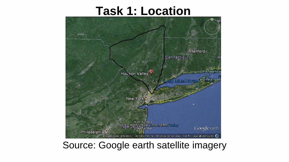
Task 1: Location
Source: Google earth satellite imagery

Task 1: Map No. 2
Source: http://www.hvedc.org/webpages/map_of_counties.aspx

Task 1: Map No. 3
Source: http://hudsonvalleyweather.com/zone-map/
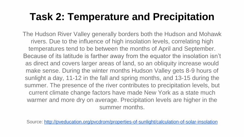
Task 2: Temperature and Precipitation
The Hudson River Valley generally borders both the Hudson and Mohawk
rivers. Due to the influence of high insolation levels, correlating high
temperatures tend to be between the months of April and September.
Because of its latitude is farther away from the equator the insolation isn’t
as direct and covers larger areas of land, so an obliquity increase would
make sense. During the winter months Hudson Valley gets 8-9 hours of
sunlight a day, 11-12 in the fall and spring months, and 13-15 during the
summer. The presence of the river contributes to precipitation levels, but
current climate change factors have made New York as a state much
warmer and more dry on average. Precipitation levels are higher in the
summer months.
Source: http://pveducation.org/pvcdrom/properties-of-sunlight/calculation-of-solar-insolation

Task 2a & 2b: Climograph
Source: http://www.ncdc.noaa.gov/IPS/lcd/lcd.html?_page=1&state=NY&stationID=14735

Task 2a & 2b: Climograph
Source: http://www.weather.gov/media/aly/Climate/KGFL_Normals_1981-2010.pdf

Task 2a & 2b: Climograph
Source: http://www.weather.gov/media/aly/Climate/KPSF_Normals_1981-2010.pdf

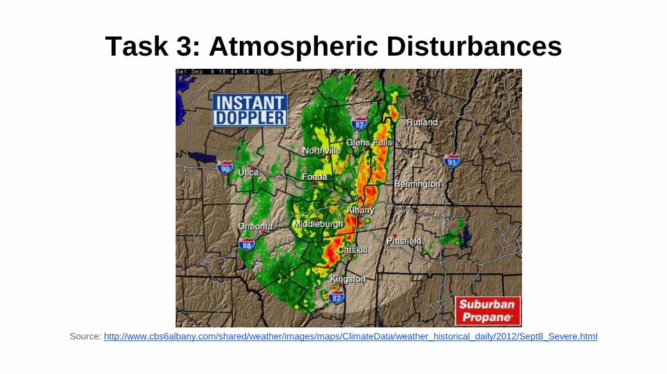
Task 3: Atmospheric Disturbances
The Hudson River Valley frequently suffers from high winds,
thunderstorms, and occasional tornadoes. The low pressure
systems throughout the east coast cause the cold fronts and
strong winds within the valley. When high pressures create strong
trade winds in lower atmospheres it creates more instability, which
can cause discrete thunderstorms that top off into tornadoes in the
valley. Air masses in this region also have a very large effect on
atmospheric disturbances. The fact that the estuary acts as an
inland wetland helps prevent atmospheric disturbances such as
flooding in this region.
Source: cbsalbany.com wind patterns and tornado
Task 3: Atmospheric Disturbances
Source: http://www.cbs6albany.com/shared/weather/images/maps/ClimateData/weather_historical_daily/2012/Sept8_Severe.html

Task 4: Evapotranspiration and Precipitation
Source: http://ny.water.usgs.gov/pubs/of/of96395/OF96-395.plate2.pdf

Task 4: Mean Annual Precipitation
Source: http://www.weather.gov/images/btv/climo/NY_annual_precip.png

Task 4: Mean Annual Evaporation
Source: https://www.extension.purdue.edu/extmedia/NCh/images/NCH-40.fig8.gif

Task 4: Net Moisture Regimes
Source: http://atlas.gwsp.org/atlas/img/map/viwb1_0_wl.png
Task 5: Climate Description
Hudson Valley is a microthermal Dfb climate because of its warmer
summers that are above 71.6 degrees while being humid
continental but with less precipitation in the winters. Precipitation
levels can go down to less than an inch and max out around 6
inches, with an average of 2.6 inches. The average temperature is
about 55 degrees, but in the winter months can get as cold as 18
degrees. Polar easterlies winds are what contribute to the colder
weather.
Source: http://www.cee.cornell.edu/academics/graduate/upload/FinalWindReportSpring2010.pdf

Task 6: Rock Types and Processes
Hudson River Valley is a physiographic section of the Ridge
and Valley province, which is part of the Appalachain region.
The Valley is made up of many different rock types ranging
the south and eastern edges of New York state, cutting
through sandstones, redbeds, and gneisses dating back to
the Triassic and Precambrian eras. Over the centuries and
through the ice ages the rivers have formed a fjord cut
caused by glacial erosion.
Source: http://3dparks.wr.usgs.gov/nyc/valleyandridge/hudsonvalley.htm

Task 6: Rock Types and Processes
● sandstone - sedimentary
● redbed - sedimentary
● gneiss - metamorphic
Source: http://www.co.dutchess.ny.us/CountyGov/Departments/Planning/nrichapthree.pdf
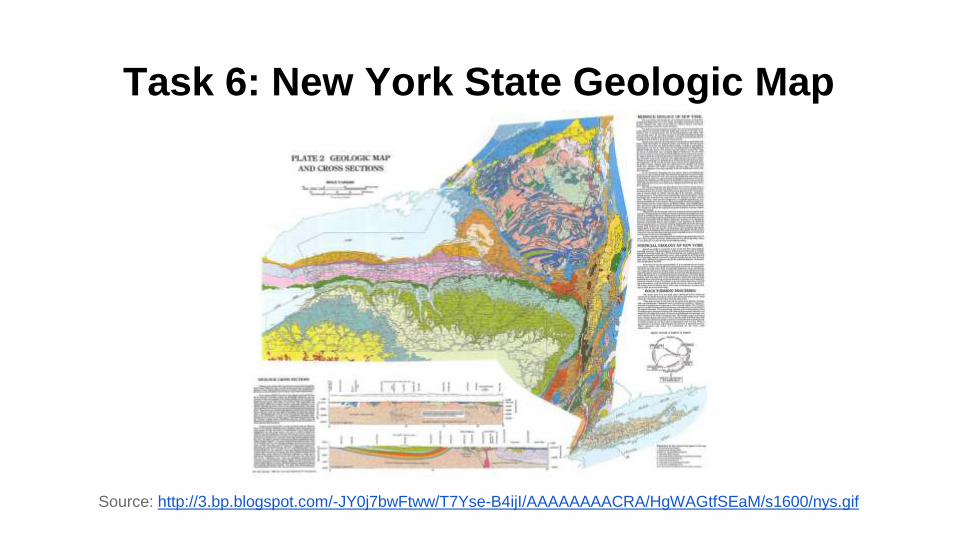
Task 6: New York State Geologic Map
Source: http://3.bp.blogspot.com/-JY0j7bwFtww/T7Yse-B4ijI/AAAAAAAACRA/HgWAGtfSEaM/s1600/nys.gif

Task 7: Crustal Formation
The valley is basin within the Canadian
shield that was subject to jointing. The basin
was probably caused by lithospheric
stretching.
Source: http://einstein.byu.edu/~masong/htmstuff/textbookpdf/C28.pdf
http://www1.gly.bris.ac.uk/~ibastow/DOCS/Pawlak11.pdf

Task 8: Weathering and mass wasting
I believe that the hudson valley underwent
the process of physical weathering, abrasion
in particular because of the large fjords
within the valley.

Task 9: Streams, Rivers, and Associated Landforms
The Hudson river is a graded river and the most
obvious landform in the Hudson River Valley. The
Hudson river doubles as both a river and a tidal estuary,
but is currently suffering major pollution issues draining
into the Atlantic discharge basin. The spring run-off from
the estuary contributes to the levels of high precipitation
in some months and prevents droughts in others.
Sources: http://www.centralia.edu/academics/earthscience/cheh_geo/lectures/streams.pdf
http://www.dec.ny.gov/lands/4923.html

Task 10c: Glacial and periglacial landforms
A glacial landform in the Hudson River Valley is a
fjord, formed by flood in which sea extends and fills
lower reaches of steep valleys. It appeared in this
region because the glacial trough intersected with
the ocean, eroding the landscape below sea level.
Source: Elemental Geosystems book

Task 10c: Glacial and periglacial landforms
Source: http://hikewestchester.myvolition.com/hudson-highlands-state-park-breakneck-ridge-loop/

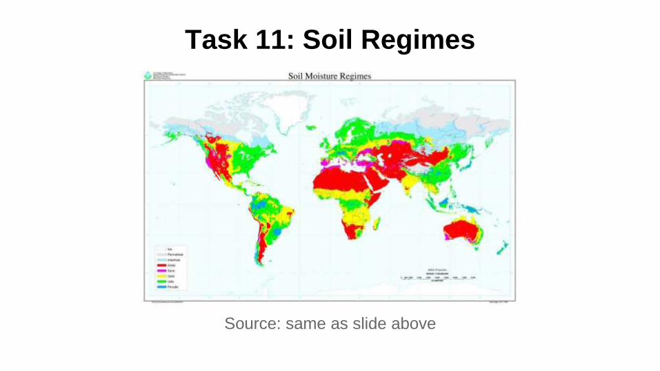
Task 11: Soil Regimes
The Hudson River Valley is a udic soil regime because it can be
considered a subhumid climate. The specific soil type is alfisols,
which has a moderate to high amount of base saturation and is
moderately weathered with an illuviated clay accumulation. It is
common among high latitudes. If it is supplemented with adequate
precipitation and temperature it can make agriculture extremely
active. In this particular area it would be more likely to produce
grains, hay, and dairy products.
Sources: http://passel.unl.edu/pages/informationmodule.php?idinformationmodule=1130447033&topicorder=11&maxto=13
Task 11: Soil Regimes
Source: same as slide above

Task 12: Plant and animal regimes
The Hudson River Valley is known as a biological crossroads for both plants and
animals. Because of its location it brings together animals of all habitats and houses
over two thousand species. Specifically, the Valley is ranked in the top four
drainages
Sources: http://blog.pennlive.com/midstate_impact/2009/05/large_boxturtle.jpg ,
http://www.dec.ny.gov/docs/remediation_hudson_pdf/hrebch3.pdf
in the world for turtle species richness. An
example is the eastern box turtle, pictured to
the left, which is for the most part New York
state specific as it needs several different
types of habitats to live.
Although the valley isn’t in a
coastal region, the fact that it doubles as an
estuary creates housing for many different
coastal species. Examples of these are the
blue crab, hudson river water nymph, least
bittern, and the black-crowned night heron.

Task 12: Plant and animal regimes
Plant harvesting is somewhat of a problem in the valley. As many plant
species die out, it is thought that botanical industries and other commercial
companies are overharvesting plants in the area that they can use to their
advantage (building canoes, tanning of leather, etc.). With that being said,
some of the plants that are currently present are the gayfeather, the native
“pink lady’s sleeper”, hummingbird mint, etc. These are able to survive
because of the estuary and the inland wetlands of the region as well as the
good amount of sunlight that stays within the region for most of the year.
Sources: http://brianaltonenmph.com/6-medical-anthropology/hudson-valley-plant-heritage/,
http://www.hvmag.com/Hudson-Valley-Magazine/June-2010/Habitat-Gardening/

Task 12: Plant and animal regimes
Source: http://1.bp.blogspot.com/-F94QjaUMpO8/TzgzWpZFlyI/AAAAAAAABgU/3WO5ufzd_Ss/s1600/USDA+hardiness+zone+map.jpg
http://planthardiness.ars.usda.gov/PHZMWeb/Images/150dpi/NE_reg_150.jpg
Task 13: References
Task 1: Reference #1: Google earth satellite imagery
Reference #2: http://www.hvedc.org/webpages/map_of_counties.aspx
Reference #3: http://hudsonvalleyweather.com/zone-map/
Task 2: Reference #1: http://pveducation.org/pvcdrom/properties-of-sunlight/calculation-of-solar-insolation
Reference #2: http://www.ncdc.noaa.gov/IPS/lcd/lcd.html?_page=1&state=NY&stationID=14735
Reference #3: http://www.weather.gov/media/aly/Climate/KGFL_Normals_1981-2010.pdf
Reference #4: http://www.weather.gov/media/aly/Climate/KPSF_Normals_1981-2010.pdf
Task 3: Reference #1: cbsalbany.com wind patterns and tornado
Reference #2: http://www.cbs6albany.com/shared/weather/images/maps/ClimateData/weather_historical_daily/2012/Sept8_Severe.html
Task 4: Reference #1: http://ny.water.usgs.gov/pubs/of/of96395/OF96-395.plate2.pdf
Reference #2: http://www.weather.gov/images/btv/climo/NY_annual_precip.png
Reference #3: https://www.extension.purdue.edu/extmedia/NCh/images/NCH-40.fig8.gif
Reference #4: http://atlas.gwsp.org/atlas/img/map/viwb1_0_wl.png

Task 13: References
Task 5 Reference #1: http://www.cee.cornell.edu/academics/graduate/upload/FinalWindReportSpring2010.pdf
Task 6 Reference #1: http://3dparks.wr.usgs.gov/nyc/valleyandridge/hudsonvalley.htm
Reference #2: http://www.co.dutchess.ny.us/CountyGov/Departments/Planning/nrichapthree.pdf
Reference #3: http://3.bp.blogspot.com/-JY0j7bwFtww/T7Yse-
B4ijI/AAAAAAAACRA/HgWAGtfSEaM/s1600/nys.gif
Task 7 Reference #1: http://einstein.byu.edu/~masong/htmstuff/textbookpdf/C28.pdf
Reference #2: http://www1.gly.bris.ac.uk/~ibastow/DOCS/Pawlak11.pdf
Task 8 Reference #1: http://gsabulletin.gsapubs.org/content/122/7-8/1067.full.pdf
Task 9 Reference #1: http://www.centralia.edu/academics/earthscience/cheh_geo/lectures/streams.pdf
Reference #2: http://www.dec.ny.gov/lands/4923.html
Task 10 Reference #1: Elemental Geosystems book
Reference #2: http://hikewestchester.myvolition.com/hudson-highlands-state-park-breakneck-
ridge-loop/

Task 13: ReferencesTask 11 Reference #1: http://passel.unl.edu/pages/informationmodule.php?idinformationmodule=1130447033&topicorder=11&maxto=13
Task 12 Reference #1: http://blog.pennlive.com/midstate_impact/2009/05/large_boxturtle.jpg
Reference #2:
http://www.dec.ny.gov/docs/remediation_hudson_pdf/hrebch3.pdf
Reference #3: http://brianaltonenmph.com/6-medical-anthropology/hudson-valley-plant-heritage/
Reference #4: http://www.hvmag.com/Hudson-Valley-Magazine/June-
2010/Habitat-Gardening/
Reference #5: http://1.bp.blogspot.com/-
F94QjaUMpO8/TzgzWpZFlyI/AAAAAAAABgU/3WO5ufzd_Ss/s1600/USDA+hardiness+zone+map.jpg
Reference #6: http://planthardiness.ars.usda.gov/PHZMWeb/Images/150dpi/NE_reg_150.jpg