registration pursuant to part x of the … · dustin angelo 150 york street , suite 410 toronto,...
TRANSCRIPT

REGISTRATION PURSUANT TO
PART X OF THE ENVIRONMENTAL PROTECTION ACT
FOR THE STOG’ER TIGHT WEST PIT EXPANSION
Stog’er Tight, Baie Verte Area
Newfoundland
ANACONDA MINING INC.
Toronto, Ont.
September, 2016

Registration Pursuant to Part X of the Environmental Protection Act For the Stog’er Tight West Pit Expansion
2
Contents 1. Name of Undertaking .............................................................................................................................. 4
2. Proponent ................................................................................................................................................ 4
2.1 Name of Corporate Body ....................................................................................................................... 4
2.2 Address .................................................................................................................................................. 4
2.3 Chief Executive Officer .......................................................................................................................... 4
2.4 Principle Contact Person ....................................................................................................................... 4
3. The Undertaking ...................................................................................................................................... 4
3.1 Nature of the undertaking ..................................................................................................................... 4
3.2. Purpose/Rationale/Need for the Undertaking ..................................................................................... 5
4. Description of the Undertaking ............................................................................................................... 5
4.1 Geographic Location .............................................................................................................................. 5
4.2 Physical Features ................................................................................................................................... 6
4.2.1 Project Site Description .................................................................................................................. 7
4.2.2 Existing Biophysical Environment ................................................................................................. 12
4.3 Construction ........................................................................................................................................ 12
4.3.1 Pre Development pumping of Fox Pond ...................................................................................... 13
4.3.2 Site Development ......................................................................................................................... 14
4.3.3 Maintaining the Water Flow ........................................................................................................ 14
4.4 Potential Sources of Pollution during Construction ............................................................................ 15
4.5 Operation ............................................................................................................................................ 15
4.6 Potential Sources of Pollution during Operation ................................................................................ 15
4.7 Potential Resource Conflicts ................................................................................................................ 17
4.8 Occupations ......................................................................................................................................... 17
4.9 Rehabilitation Plan .............................................................................................................................. 18
4.10 Project Operation Considered ........................................................................................................... 18
4.11 Project Related Document ................................................................................................................ 18
5. Approval of the Undertaking ................................................................................................................. 20
6. Schedule ................................................................................................................................................ 20
7. Funding .................................................................................................................................................. 20
8. Submission ............................................................................................................................................. 20
9. Appendices ............................................................................................................................................ 21

Registration Pursuant to Part X of the Environmental Protection Act For the Stog’er Tight West Pit Expansion
3
Figures Figure 1: Stog’er Tight Site Location ................................................................................................................ 8
Figure 2: Stog’er Tight and Pine Cove Drainage Channel, August 22nd, 2016 ................................................ 9
Figure 3: Stog’er Tight Development and Water Treatment Plan, August, 2016 ......................................... 10
Figure 4: Fox Pond Dewatering Plan, August 22nd, 2016 ............................................................................. 11
Figure 5: Closure Plan .................................................................................................................................... 19
Tables Table 1: Construction Phase Occupation List ................................................................................................ 17
Table 2: Operation Phase Occupation List .................................................................................................... 18
Table 3: List of Permits, Licences and Approvals ........................................................................................... 20
Table 4: Project Schedule .............................................................................................................................. 20

Registration Pursuant to Part X of the Environmental Protection Act For the Stog’er Tight West Pit Expansion
4
1. Name of Undertaking Stog’er Tight West Pit Expansion
2. Proponent
2.1 Name of Corporate Body Anaconda Mining Inc.
2.2 Address P.O. Box 238
Baie Verte, NL
A0K1B0
2.3 Chief Executive Officer Dustin Angelo
150 York Street, Suite 410
Toronto, Ontario, M5H 3S5
Canada
(416) 304-6622
2.4 Principle Contact Person Jordan Cramm, Project Development Coordinator
P.O Box 238
Baie Verte, NL, A0K 1B0
Canada
(709) 800-7332
3. The Undertaking
3.1 Nature of the undertaking Anaconda Mining Inc. (“Anaconda” or the “Company”) proposes to expand its West Pit for
approximately 0.395 hectares of land below the current water level of Fox Pond (on the northern side
of the approved and released Stog’er Tight West Pit site) at mining lease ML-193-A in order to mine
a deeper portion of the ore resource. Anaconda proposes to temporarily lower the water level in the
Fox Pond from 114 to 111 metres above sea level (“ASL”) elevation and keep it at this level until
mining is completed, at which point this area will be flooded and water levels will climb back to its
natural levels. This mineable ore reserve/resource totals approximately 140,000 tonnes of ore
(33,000 approved with previous application). The deposit will be mined by open pit mining methods
over an eight to ten-month period commencing in winter/spring of 2017/2018. Waste will be

Registration Pursuant to Part X of the Environmental Protection Act For the Stog’er Tight West Pit Expansion
5
stockpiled on already approved dumps while all the ore will be trucked to Anaconda’s operating Pine
Cove Mill facility for processing.
3.2. Purpose/Rationale/Need for the Undertaking Anaconda is planning on expanding their West Pit at the Stog’er Tight Project to maximize the
resource, increase the ore reserve value. The Stog’er Tight Project received all necessary approvals
to start commercial production in the fall of 2015. Two pits, East and West, were designed outside of
the buffer around Fox Pond. Anaconda has conducted test mining during the fall and winter of
2015/2016 when a bigger sample of 32,000 tonnes was processed at its Pine Cove Mill. As the mining
activities took place in the West Pit, first the backfill placed during previous mining activities was
taken out and ore vein was exposed at the bottom of the pit. As the backfill was significantly deeper
than anticipated, it was concluded that taking this resource would require deepening of the West Pit
that would encroach temporarily on Fox Pond. As Anaconda wanted first to test this deposit and
confirm its tonnages, grade and metallurgical qualities, the approach has changed and a bulk sample
was taken from the East Pit. Our conclusion from this test was that ore from Stog’er Tight can be
successfully mined and processed at the Pine Cove Facility so Anaconda has decided to go ahead with
proposing a development of this deeper resource.
4. Description of the Undertaking In order to develop the mineral resource in the West Pit, Anaconda will temporarily decrease water
levels in the adjacent Fox Pond from the current water elevation of 114 metres ASL down to 111
metres ASL during mining operations. This water level will be maintained during mining operations
to prevent the water from entering the pit during the 8- to 10-month mining operation. The mining
operation fleet will consist of trucks and shovels with supporting equipment including dozers and
graders will be used to build and maintain the roads and dumps. Anaconda will temporarily install a
pumping system with a barge in the middle of the Pond in order to draw the water level down. Water
would be pumped west and to the outflow of the Fox Pond which would flow downstream in the
chain of the tributaries and lakes that make a part of the South Brook drainage area. As Fox Pond is
the head lake, the downstream water flow of Fox Pond would be maintained during mining operation
to minimize the impact to the habitat. The water level is expected to resume its normal levels once
mining operations cease.
4.1 Geographic Location The proposed location for expansion is on the existing Stog’er Tight Property. The Stog’er Tight
Property (Mining Lease No. 193-A, located near Ming’s Bight, Baie Verte, Newfoundland) lies on the
Point Rousse Peninsula (see Figure 1).
The Stog’er Tight Deposit is located approximately two kilometres southwest of Ming’s Bight near
Baie Verte, north-central Newfoundland. Ming’s Bight is about 26 kilometres by road from the town
of Baie Verte. The Pine Cove mine road, an existing gravel road, located approximately two

Registration Pursuant to Part X of the Environmental Protection Act For the Stog’er Tight West Pit Expansion
6
kilometres south of Ming’s Bight, leads directly onto the Stog’er Tight Property (see Figure 1 and
Figure 2).
The Stog’er Tight Property is included under Mining Lease 193-A and Map Staked License No’s.
15808M & 12433M (Figure 1). The claims are located on NTS map 12H/16 at UTM coordinates
5,535,000N & 566,000E (NAD 1927, Zone 21)
The Baie Verte Peninsula coastline is rugged and highly irregular with cliffs and steep slopes
prevailing. On the Stog’er Tight Property, moderate to steep slopes above Baie Verte rise to a
maximum elevation of 170 metres, averaging 115 to 140 metres ASL. Ponds and small lakes are
common, the largest being the Green Cove and Scrape Ponds. Vegetation consists of mature spruce
and fir, largely cutover, with re-growth of alder, birch and young fir. Alders are prevalent in older
stripped and wet areas.
Fox Cove Pond (approx. elevation 114 metres) is north of the approved Stog’er Tight Project and is
the head water of the system that joins South Brook drainage system.
The terrain surrounding the Stog’er Tight Project site is generally rolling, with gradients over portions
of the site ranging up to 22%. The surrounding terrain is typical of the Newfoundland upland areas,
with relatively dense vegetation and tree cover, interspersed with small ponds and bogs. The grey
volcanic bedrock in the area is overlain with a thin layer (0-2.5 m) of unconsolidated material being
comprised of peat, loose brown sand and gravel.
4.2 Physical Features Geographical Setting
The Stog’er Tight Property is located on the Point Rousse Peninsula of the Baie Verte Peninsula and
within a small, locally restricted watershed containing Fox Pond plus several ponds and small streams.
These water bodies flow westerly into the Atlantic Ocean at South Brook (Figure 1 and Figure 2).
Larger fir and spruce trees cover the majority of the Stog’er Tight Property with outcrop making up
less than 3%. Most of the area was logged by Kruger during the early 1990’s and only small pockets
of useable timber remain. Glacial till overburden is generally thin likely ranging from 0.1 metres to
less than five metres thick although it may be up to ten metres thick in prominent linears.
Topography
Topography in the area is generally rolling to steep and rough terrain with elevations ranging from
sea level to 180 metres ASL (Figure 2). The existing open pit is at elevation 31 to 46 metres ASL,
approximately 2 to 15 metres above Fox Pond.
Climate
The climate in the north central Baie Verte area of Newfoundland is temperate, with six to seven
months of snow-free and ice-free seasons from April-May to November. Typical seasonal variation
includes snowy winters from late November to March and summers from June through September. At

Registration Pursuant to Part X of the Environmental Protection Act For the Stog’er Tight West Pit Expansion
7
the Baie Verte weather station the approximate 30-year averages of the mean winter temperature
(i.e. the mean monthly averages of November to March) is -6O C and ranges from +0.2O C in November
to –10O C February. Winter conditions, with moderate to heavy snowfalls usually begin in early
December and remain until late-March. The average winter snowfall is approximately 49 centimetres
per month with ranges of 31 centimetres in November to 88 centimetres in January.
4.2.1 Project Site Description The Fox Pond is a head lake that has no direct inflows from tributaries or ponds, but rather is fed via
drainage from the surrounding area. Fox Pond drains west through the outflow into a boggy area,
which is drained via a small creek into Camp Pond. Camp Pond drains through its outflow (a 4 ft
culvert) into another small creek and further into the boggy area and through a 2 ft culvert into the
South Brook drainage system and then into the sea. Refer to Figure 2 and Figure 3 for details.
Anaconda hired Gemtec Consulting firm (“Gemtec”) to carry out a habitat and fish study of Fox Pond,
its outlet and the tributary that connects the outlet to Camp Pond. This study found that Fox Pond
and its outlet are fish habitats that are being inhabited by Brook Trout. This report is attached to this
e-mail as for reference. A desktop hydrology assessment was also completed by Gemtec to determine
the inflow into Fox Pond. Anaconda carried the volumetric calculations of the pond volumes, creek
and culverts velocities and flows in order to determine the best action plan to minimize the impact
on the environment.
Gemtec’s assessment included the collection of habitat information (substrate, flow, bank erosion,
vegetation cover, etc.), a water quality assessment (measurements of temperature, conductivity,
dissolved oxygen, etc.), a fish survey (live capture of fish from the waterbody) and a hydrological
study. This study is included as an attachment to this application.
Acid Rock Drainage testing has been performed on bulk samples from the designed pit location and
current waste dump facility, confirming that the minerology within Stog’er Tight is non-acid
generating (RPC, 2015).

Registration Pursuant to Part X of the Environmental Protection Act For the Stog’er Tight West Pit Expansion
8
Figure 1: Stog’er Tight Site Location

Registration Pursuant to Part X of the Environmental Protection Act For the Stog’er Tight West Pit Expansion
9
Figure 2: Stog’er Tight and Pine Cove Drainage Channel, August 22nd, 2016

Registration Pursuant to Part X of the Environmental Protection Act For the Stog’er Tight West Pit Expansion
10
Figure 3: Stog’er Tight Development and Water Treatment Plan, August, 2016

Registration Pursuant to Part X of the Environmental Protection Act For the Stog’er Tight West Pit Expansion
11
Figure 4: Fox Pond Dewatering Plan, August 22nd, 2016

Registration Pursuant to Part X of the Environmental Protection Act For the Stog’er Tight West Pit Expansion
12
4.2.2 Existing Biophysical Environment The Stog’er Tight site falls within the Northshore Ecoregion of Newfoundland which Damman (1983)
characterizes as mostly forest-covered with some barren areas (particularly in coastal localities).
The quality and height of forests in this ecoregion tends to deteriorate towards the coast and with
increased wind exposure. The geographic variation of this ecoregion is from east (Bonavista
Peninsula) to west (Baie Verte Peninsula) in terms of shortening of the vegetative season, an
increase in summer temperatures, and drastic changes in winter snow cover from shallow and
intermittent in the east to deep and permanent in the west (Damman, 1983).
Big game, furbearers and a wide range of birds occur in the area, and have generally adapted to
human activities at Pine Cove and other sites in the area. The principle large mammal species in the
area is moose (Alces alces), which is found within Moose Management Area 14 – Baie Verte. Moose
densities are reported to be low and harvesting of moose has at times been reported to be quite
heavy. Information on the abundance and distribution of moose and moose wintering areas
(specialized habitat types) at the proposed mine site were collected through a survey undertaken in
1994 (JW, 1994).
Caribou (Rangifer tarandus) are not hunted at present on the Baie Verte Peninsula. The nearest
concentration of this species, the Hampden, the Humber, and the Gaff Topsails herds occur well to
the south of this region.
Black bears are known to occur in the region.
Other mammals such as furbearers and small mammals occur, but there is generally little
information available on these species. Beaver (Castor Canadensis) are common in the ponds and
streams in the area, although none have been observed.
The abundance of high profile raptor species such as Bald Eagle (Haliaetus leucocephalus) and
Osprey (Pandion haliaetus) is probably low in the area unless sufficient cliff-nesting habitat is
available; the local forest is probably unsuitable for nest sites. An aerial survey for raptors and nest
sites was conducted in 1994 (JW, 1994).
The Fox Pond watershed is approximately 8 square kilometres in area. The largest pond, Fox Pond
is up to 10 metres deep. The only fish species reported in the watershed are brook trout (Salvelinus
fontinalis), which are distributed from Pine Cove Pond downstream to the steep gradient
approaching the shore of Baie Verte (Gemtec, 2016).
4.3 Construction The construction phase of the site development is broken up into the following areas:
Pre-development pumping of the Fox Pond to achieve an elevation of 111 metres ASL
Mining while water level is maintained at or below an elevation of 111 metres ASL

Registration Pursuant to Part X of the Environmental Protection Act For the Stog’er Tight West Pit Expansion
13
Water supply maintained to downstream habitat until Fox Pond reaches its natural level
4.3.1 Pre Development pumping of Fox Pond In preparation of the mining activities, the Fox Pond water level would be temporarily lowered from
elevation of 114 to 111 metres and will be maintained at this level during Mining operations.
All water discharging from Fox Pond will remain within the natural water drainage channel.
Discharge will flow through Fox Pond’s adjacent wetlands, Camp Pond, South Brook and out to sea.
Pumping is planned to be gradual (approximately 6,000 cubic metres a day) in consideration of the
downstream flow capacity.
Dewatering is planned to begin in December of 2017 and is forecasted to last 1.5-2 months for a 3-
metre vertical drop in surface water. A 20 horsepower pump will be situated on the eastern side of
the pond and mounted on a floating dock to minimize the pump’s contact with the pond-floor. A
fish screen would be installed on the pump intake in consideration of Fox Pond’s fish habitat. The
Company will also have a biologist visit the site once the system is set up. The pump is projected to
dewater at a rate of 6,000 cubic metres per day. There will be approximately 300,000 cubic metres
of water removed from the pond initially, leaving approximately 200,000 cubic metres as the interim
Fox Pond. This remaining water will support the fish community during the mining activities.
Anaconda will keep the water flow to the outlet and its downstream boggy areas to maintain the
habitat. Prior to pumping, a small temporary berm/dyke will be constructed at the outflow to keep
water from circulating back to Fox Pond and to maintain the water levels in outflow. This dyke will
be constructed out of the mine waste rock and would be 2-3 metres wide and 4-7 metres long. Upon
project completion this dyke will be removed. An energy dissipation pad would be constructed
downstream of the berm to minimize the erosion from the dewatering system discharge. Refer to
Figure 4 for details.
During dewatering, the pump will discharge into a downstream wetland west-south-west of Fox
Pond. The consequential flow rate downstream has been reviewed for overflow analysis. The
limiting factor downstream are two culverts. The first is on the downstream side of Camp Pond and
has a 4 ft wide opening. The second 2 ft culvert is located along the Pine Cove Mine access road and
connects the tributary discharging from Camp Pond and surrounding boggy area with the South
Brook water shed. Refer to Figure 2 for locations.
The Company and Gemtec have completed hydrology study and flow calculations in order to
determine if the planned dewatering rates can be achieved through 4-ft and 2-ft culverts and various
tributaries that connect Fox Pond to South Brook watershed. Manning formula was used to
determine the cross sectional flow in the open channel and in the culverts. Culverts can handle
manifolds bigger flows (3.5 to 8 times for 2-ft and 4-ft culverts respectively), while even for the
smallest measured channel the proposed dewatering rate is 2.5 times less then what the channel
can handle. The smallest section is 0.5 metres wide and 0.15 metres high (Gemtec Report). The

Registration Pursuant to Part X of the Environmental Protection Act For the Stog’er Tight West Pit Expansion
14
calculated flow is 14,300 m3/day. The Manning formula is used to calculate this flow with roughness
coefficient of 0.035 as recommended for natural streams.
4.3.2 Site Development The current water elevation sits at approximately 114 metres ASL, depending on the time of year.
The new pit rim overlaps with the south-west side of Fox Pond and intersects with the floor of the
pond at approximately 112 metres ASL. After considering the slope of the pond floor, a minimum
15-metre distance from the designed West Pit rim requires the water elevation in Fox Pond to drop
to 111 metres ASL. Refer to Figure 3 and Figure 4 for details. This will give Anaconda a bit more than
the suggested 15 metres working distance to avoid issues with water leakage through substrate or
back-break along the pit rim. The total area of overlap between the West Pit and Fox Pond will be
approximately 3,950 m2 of the 97,500 m2 pond surface (measured in two dimensional space) or 4%
of total pond surface.
The Stog’er Tight Project is opening for production for approximately 8-10 months in 2018. The West
Pit has a total tonnage capacity of 1.1 million tonnes with forecasted ore tonnes of 140,000 tonnes
at 2.35 (3.6 gram-per-tonne (“g/t”) Au undiluted) grams of gold per tonne. Drilling and blasting will
begin shortly after Fox Pond’s water elevation reaches 111 metres above sea level. Construction of
a small temporary dyke on the inlet of the wetlands west of Fox Pond is scheduled prior to the
pumping of the pond, and excavation around the site will happen during pumping in preparation of
mucking production.
A six-inch water line would be assembled along the perimeter of the pit and connected to a floating
barge that would host a 20hp pump. Intake would be set close to the middle of the pond, above its
deepest point. The water would be discharged west of the outflow over a dyke, with the intention
to at first decrease Fox Pond water levels and then to keep the water flowing to the outlet.
The heavy equipment requirement for Stog’er Tight will be as follows: 1x 290 LC John Deer, 3x 300D
John Deere Articulated Haul Trucks, 1x 700K John Deere Dozer and 1x top hammer rotary drill. The
blasting product to be used is a Titan XL 2000G emulsion.
There are two waste dumps planned to support a total dumping capacity of 1.6 million tonnes. The
East Dump is designed on the east side of pit operations but has already been utilized in previous
operations. The South Dump will be the main waste dump facility; the minerology within Stog’er
Tight and associated waste rock has been tested for Acid Rock Drainage and have been confirmed
as non-acid generating.
4.3.3 Maintaining the Water Flow Fox Pond water level would be lowered by 3 metres during mining operations for a period of 8-10
months. At the end of the pit operations, the pond water level will naturally rise to its natural water
level of 114 metres ASL. Prior to the start of mining and during the mining operations, water would
be pumped to the outflow and the wetlands to the west and downstream of Fox Pond.
Registration Pursuant to Part X of the Environmental Protection Act For the Stog’er Tight West Pit Expansion
15
4.4 Potential Sources of Pollution during Construction The most probable sources of potential pollution are related to the use of heavy equipment. This
includes accidental spills consisting of diesel fuel, oil, and hydraulic fluids. Sedimentation from the
placement of rock is also a potential hazard, but will be limited due to catchment ditches and the
use of filter fabrics. Dust may also be a potential source of pollution, but dust suppression
techniques such as water and calcium have proved valuable in mitigating such pollution during
existing mining activities. Collection ditches and a settling pond will be utilized where needed during
the construction phase.
4.5 Operation During the operation of this facility, haul trucks will be used to bring the waste material from the pit
to two waste rock storage area. Ore would be stockpiled and hauled to the Pine Cove Mill for
processing.
4.6 Potential Sources of Pollution during Operation Potential sources of pollution during the operation are focused around the accidental discharges of
vessel fuels and engine oils, accidental spills of heavy equipment (Loader) fuel, oil and hydraulic
fluids and the potential dust from mining activities.
Any dewatering from the pit or run-off from equipment will be directed via a drainage ditch and
collection system to a settlement pond between the west pit and the wetlands, the settlement pond
will be tested periodically and discharged into the wetlands once deemed safe for the environment.
Geofabric and silt fence will be installed between Fox Pond and the West Pit to catch any water
drainage from the mining area prior to discharging into the sediment pond.
All infrastructure on-site will be temporary and easily removed during mine closure.
The crests of overburden between mined and original ground will be contoured and the land will be
scarified where appropriate to limit erosion and facilitate regrowth.
As part of Anaconda’s development plan, routine site inspections will be scheduled, documented
and reported to ensure ecological stability in the area.
From a Project Planning perspective, Anaconda has incorporated the following measures:
Timing with spawning periods and habitat assessment conducted during low tide;
Site Selection with infrastructure constructed away from water channels, along with the
waste dump; and
Contaminant and Spill Management by lining the overburden between Fox Pond and the
West Pit.

Registration Pursuant to Part X of the Environmental Protection Act For the Stog’er Tight West Pit Expansion
16
From an Erosion and Sediment Control perspective, Anaconda has incorporated the following
measures:
A settling pond between the West Pit and the wetland area will capture run-off from site
and water discharge from the pits. Regularly scheduled sampling of the inflow will occur and
the pond will be released into the environment when appropriate;
To minimize the erosion at the outflow an energy dissipation pad would be constructed at
the downstream side of the dyke at the discharge point of the pond de-watering system,
and;
Silt fencing will be used as erosion control measure during the construction and dismantling
the outflow berm.
From a Shoreline Re-vegetation and Stabilization perspective, Anaconda has incorporated the
following measures:
Minimizing riparian vegetation clearing by design;
All banks and the shoreline between the West Pit and Fox Pond will be contoured and
graded to minimize erosion;
Minimal disturbance to the shoreline substrate apart from pit design area;
All objects/infrastructure will be removed from site once production comes to a close at
Stog’er Tight, and;
Additional sediment control measures will be put in place when re-flooding the pit to
minimize sediment introduction to Fox pond including pit water pumping to sediment pond
and/or placing hay bales or silt fences at the outflow of the pit.
From a Fish Protection perspective, Anaconda has incorporated the following measures:
Consulting firm Gemtec, specializing in environmental services, has carried out a habitat
assessment of Fox Pond;
Gemtec's habitat assessment includes the collection of habitat information (substrate, flow,
bank erosion, vegetation cover, etc.);
A water quality assessment (measurements of temperature, conductivity, dissolved oxygen,
etc.), a fish survey (live capture of fish from the waterbody), and a hydrological study;
Fish screen will be installed at the intake side of the pumping system;
Anaconda will be stemming each hole that's loaded with our emulsion product to reduce
blasting debris;

Registration Pursuant to Part X of the Environmental Protection Act For the Stog’er Tight West Pit Expansion
17
All blasting will occur within the confines of the open pits and each drillhole's detonation
will be delayed at a minimum of 25 milliseconds, and;
As the pond area dries up due to decreasing water levels Anaconda personnel or contractors
will be inspecting the area for any stranded fish. All fish will be captured and released back
into the pond.
From an Operation of Machinery perspective, Anaconda has incorporated the following measures:
We ensure that the equipment is well maintained and is in good working condition before
it arrives on site; a thorough inspection at the maintenance shop in Pine Cove before
transportation will be the standard.
If a harmful substance is released in the pit from the operating equipment, the substance
will be removed from the pit and transported to a hazardous waste location that will be
completely enclosed.
4.7 Potential Resource Conflicts Resource conflicts are not expected. The area is currently not used by fishers and the nearest
residential areas are Baie Verte and Ming’s Bight, approximately 3 kilometres from the proposed
project location.
If, however, historic resources are encountered, work in the area of the discovery will stop and the
proper authorities will be notified in accordance with the Historic Resources Act (1985).
4.8 Occupations Site construction and operations from the proposed rock export is anticipated to consist of the
occupations outlined in Table 1 and Table 2 below:
Table 1: Construction Phase Occupation List
Construction Phase
Occupation Quantity National Occupational
Classification
Health & Safety Supervisor 1 2263
Site Supervisor/Engineer 1 7217
Heavy Equipment Operators 1 7421
Heavy Equipment Mechanics 1 7312
Labourer 4 7611
Total 8

Registration Pursuant to Part X of the Environmental Protection Act For the Stog’er Tight West Pit Expansion
18
Table 2: Operation Phase Occupation List
Construction Phase
Occupation Quantity National Occupational
Classification
Health & Safety Supervisor 1 2263
Site Supervisor 1 7217
Heavy Equipment Operators 3 7421
Truck Drivers 8 7411
Heavy Equipment Mechanics 2 7312
Labourer 4 7611
Total 19
4.9 Rehabilitation Plan A rehabilitation plan is under development but won’t significantly differ from Anaconda’s already-
approved plan. Changes will be made upon project approval, including the conditions supplied with
the approval. The West Pit will naturally flood to an elevation of 114 metres ASL once mining
operations cease. See Figure 5.
4.10 Project Operation Considered Consideration has been given to alternate means of carrying out the proposed development. This
has included various dock locations and orientations. This location has been generally accepted
based on the depth of water in the area in addition to wind and wave patterns.
The laydown area was selected to utilize the low lying elevation in order to maximize the stockpiles
which can be stored in the area.
4.11 Project Related Document June 18th, 2015 Anaconda Mining was released from Stog’er Tight Project Registration as project
was already reviewed with 2010 Environmental Assessment when project was in the ownership of
Tenacity as there was no material changes between the plans.

Registration Pursuant to Part X of the Environmental Protection Act For the Stog’er Tight West Pit Expansion
19
Figure 5: Closure Plan

Registration Pursuant to Part X of the Environmental Protection Act For the Stog’er Tight West Pit Expansion
20
5. Approval of the Undertaking Table 3 below is a list of permits, licences and approvals which are likely required for this project.
Table 3: List of Permits, Licences and Approvals
Approvals/Certificate/Permits Regulatory Authority
NL Environmental Assessment Registration NL Department of Environment and Conservation, Environmental Assessment Division
Fish Habitat Approval Fisheries and Oceans Canada, Habitat Protection Division
Application to Alter a Body of Water NL Department of Environment and Conservation, Water Resources Division
Surface Lease NL Department of Natural Resources, Minerals Lands Division
6. Schedule Table 4 below illustrates the project schedule.
Table 4: Project Schedule
Item Date
Registration Document Submission August-16
Government Review and Decision November-16
Lowering water level December-16
Mining February-17
Pit Closure November-17
7. Funding The capital cost of this project is estimated to be approximately $1,100,000. Total operational cost
is estimated at $9,100,000. The funding for the project will be provided by Anaconda Mining Inc.
8. Submission Date: September 6th, 2016
__________________________________
Gordana Slepcev, VP Technical Services
Anaconda Mining Inc.

Registration Pursuant to Part X of the Environmental Protection Act For the Stog’er Tight West Pit Expansion
21
9. Appendices
1) Letter from Derrick Dalley, Minister (Government of Newfoundland and Labrador), October 23, 2015
2) Gemtec Fish Habitat Assessment, August 30, 2016
3) Gemtec Desktop Hydrological Assessment, August 29, 2016
4) Letter from Bas Cleary, Director, Assessment Division (Government of Newfoundland and Labrador),
June 18, 2015


Fish Habitat Assessment Fox Pond and Fox Pond Outflow Stog’er Tight Mine near Ming’s Bight Newfoundland and Labrador August 30, 2016 Prepared for Anaconda Mining Inc. Project No. 80016.01

August 30, 2016 File: 80016.01 – R01
Anaconda Mining Inc.
238 Highway 410
Baie Verte, NL
A0K 1B0
Attention: Gordana Slepcev, P.Eng., M.Sc.,
Manager of Technical Services
Re: Fish Habitat Assessment for Fox Pond and Fox Pond Outflow
Stog’er Tight Property, located near Ming’s Bight, Newfoundland & Labrador
Please find enclosed the Fish Habitat Assessment report for Fox Pond and its Outflow located on
the Stog’er Tight Mine Property near Ming’s Bight, Newfoundland and Labrador. GEMTEC Limited
was retained to conduct the desktop studies, field work and associated reporting. The field
component of the habitat assessment was conducted on July 11 to July 14, 2016.
Sincerely,
________________________________
Darrol Rice, B.Tech. (Env), P.Tech., EP, PMP
Senior Project Manager
GEMTEC Limited
Enclosures
n:\files\80000\80016.01 - anaconda stoger tight\fish habitat assessment\report\report\2016 fish habitat survey (fox
pond and outfall) final.docx

ii
Fish Habitat Assessment
Fox Pond & Fox Pond Outflow
Stog’er Tight Mine near Ming’s Bight, Newfoundland & Labrador
Table of Contents
Table of Contents ........................................................................................................................ ii
Appendices ................................................................................................................................ iv
List of Figures ............................................................................................................................ iv
List of Tables ............................................................................................................................. iv
Executive Summary .................................................................................................................... v
1.0 Introduction ..................................................................................................................... 1
2.0 Scope of Work ................................................................................................................. 1
2.1 Physical Habitat Survey ............................................................................................. 1
2.2 Water Quality Monitoring ........................................................................................... 2
2.3 Fish Survey................................................................................................................ 2
3.0 Materials and Methodology .............................................................................................. 4
3.1 Physical Habitat Survey ............................................................................................. 4
3.1.1 Predictive Mapping and Species at Risk Screening ............................................. 4
3.1.2 Field Reconnaissance .......................................................................................... 5
3.2 Water Quality Monitoring ........................................................................................... 8
3.3 Fish Survey.............................................................................................................. 11
4.0 Summary of Findings ..................................................................................................... 12
4.1 Physical Habitat Survey ........................................................................................... 12
4.1.1 Species at Risk Desktop Survey ........................................................................ 12
4.1.2 Watershed and Hydrological Desktop Study ...................................................... 12
4.1.3 Fox Pond Habitat Characteristics ....................................................................... 13
4.1.4 Fox Pond Outflow .............................................................................................. 13
4.2 Water Quality Monitoring ......................................................................................... 15
4.2.1 Fox Pond ........................................................................................................... 15
4.2.2 Fox Pond Outflow .............................................................................................. 16
4.3 Fish Survey.............................................................................................................. 17
4.3.1 Fox Pond ........................................................................................................... 17
4.3.2 Fox Pond Outflow .............................................................................................. 18

iii
5.0 Conclusions ................................................................................................................... 20
6.0 Closure .......................................................................................................................... 21
7.0 References .................................................................................................................... 22
iv
Fish Habitat Assessment
Fox Pond & Fox Pond Outflow
Stog’er Tight Mine near Ming’s Bight, Newfoundland & Labrador
Appendices
A
B
C
D
Site Photos
Species at Risk Information
Stream Assessment Forms
Water Quality Results
List of Figures
Figure 1: General Site Overview ................................................................................................. 3
Figure 2: Substrate Sampling Sites ............................................................................................. 7
Figure 3: Water Quality Sampling Sites ..................................................................................... 10
List of Tables
Table 1: Summary of Findings .................................................................................................... v
Table 2: Substrate Classification ................................................................................................. 6
Table 3: Flow Measurements in Fox Pond Outflow on July 13, 2016 ........................................ 14
Table 4: Summary of Water Quality Results in Fox Pond on July 11 and July 13, 2016. ........... 15
Table 5: Turbidity Reading in Fox Pond .................................................................................... 16
Table 6: Summary of Water Quality Results in Fox Pond Outflow on July 12, 2016. ................. 16
Table 7: Turbidity Reading in Fox Pond Outflow July 12, 2016 ................................................. 17
Table 8: Summary of Fish Captured by Fyke Net in Fox Pond .................................................. 18
Table 9: Summary of Electrofishing Presence / Absence Survey in Outflow (July 13, 2016) ..... 19

v
Fish Habitat Assessment
Fox Pond & Fox Pond Outflow
Stog’er Tight Mine near Ming’s Bight, Newfoundland & Labrador
Executive Summary
In 2016, GEMTEC Limited (“GEMTEC”) was retained by Anaconda Mining Inc. to complete a fish
habitat assessment in Fox Pond and its Outflow on the Stog’er Tight Mine site, near Ming’s Bight,
Newfoundland. Central coordinates for the project area are: 49°58’03.05”N, 56°04’34.32”W. The
habitat assessment includes the collection of habitat information (substrate, flow, bank erosion,
vegetation cover, etc.), a water quality assessment (temperature, dissolved oxygen, pH, etc.), a
fish survey (live capture of fish from the waterbody) to determine relative abundance, and a
hydrological study. A GEMTEC environmental biologist completed the field study component of
the habitat assessment on July 11 to July 14, 2016. A summary of our findings is presented in
Table 1.
Table 1: Summary of Findings
Assessment
Component
Results
Physical Habitat Characteristics
Fox Pond Bank stability is “fair” with 50% to 80% stable banks. Substrate in the centre / deep
portions of the pond is mostly organic muck. Landward substrate is rubble, rock,
and boulders. Overhanging vegetation is present throughout.
Fox Pond Outflow Five varying habitat types are present along the length of the Outflow; the
upstream channel, open-water wetland, rock channel, grass wetland and the
shrub wetland, respectively. All habitat types contain different substrate size and
vegetation cover.
Water Quality Assessment
The assessed parameters meet the Canadian Council of Ministers of the Environment (CCME) Water
Quality Guidelines for the Protection of Freshwater Aquatic Life (FWAL) and Environment Canada (EC)
Freshwater targets for good water quality, with the exception of four pH measurements in Fox Pond.
Temperatures are “ideal” salmonid habitat and turbidity is within the CCME Water Quality Guidelines for
the Protection of FWAL normal range.
Fish Survey
Nine Brook Trout (Salvelinus fontinalis) were captured in Fox Pond. The fish ranged in size from 18 cm
– 32 cm. Additionally, schools of smaller sized (4cm – 8cm) Brook Trout were observed in Fox Pond
during the study period. Ninety Brook Trout (2 cm – 15 cm) were captured and released in the Fox Pond
Outflow.

vi
This report summarizes the findings of the 2016 Fish Habitat Assessment in Fox Pond and the
Fox Pond Outflow. The assessment presents preliminary information on the quantity and quality
of the fish habitat in the proposed project area. The assessment was conducted using the DFO
Standard Methods for evaluating streams, rivers and lakes.
Based on the findings of this assessment, the following conclusions are presented:
Fox Pond and the Outflow contain varying substrate that can support fish species through
all life stages. Minimal erosion was observed throughout the assessment area. The banks
of Fox Pond and the Outflow are “fair” with 50%-80% of the bank being stable.
Overhanging vegetation was present in both assessment areas to provide shade, hiding
spots and food inputs for aquatic species.
The majority of the project site is unaltered and in a natural state. A small portion of the
southern bank and submerged substrate is blast rock from the adjacent mining activity.
No records of species at risk were reported within 5 kilometres of the project area. One
fish species (Banded Killfish) was identified on Expert Opinion Maps and may be present
based upon estimates of habitat distribution; however, the preferred habitat for this
species is not present on site.
In general, the water quality in Fox Pond and the Outflow are good for salmonid species.
Water temperatures were consistently below 17.97°C which is classified as intermediate
conditions. Dissolved oxygen concentrations ranged from 7.17 mg/L - 9.84 mg/L,
conductivity ranged from 95 µS/cm - 121 µS/cm and pH ranged from 6.02 - 9.52, all of
which are within the CCME FWAL guidelines and EC Water Quality targets.
Normal range turbidity readings were found in both Fox Pond and the Outflow. Fox Pond
has good clarity and light si

GEMTEC Limited Fish Habitat Survey for Fox Pond and Outflow
80016.1 – R01 Stog’er Tight Mine, near Ming’s Bight, Newfoundland
2
2.2 Water Quality Monitoring
Water quality parameters were measured throughout Fox Pond and the Outflow. The scope of
work for the water quality monitoring was as follows:
Measurement of temperature, conductivity, dissolved oxygen and pH at various
sampling sites in Fox Pond and the Outflow;
Turbidity readings were collected in the surface water of Fox Pond and along the length
of the Outflow; and
Evaluation of the light penetration / clarity of the water contained within Fox Pond.
2.3 Fish Survey
A three-pronged approach was used to preliminarily survey the presence of fish in Fox Pond
and the Outflow. The scope of work for the fish survey is as follows:
Installation of minnow traps in shallow portions of Fox Pond and the Outflow;
Installation of a fyke net in Fox Pond; and
Electrofishing the length of the Outflow.
The project area and waterbody boundaries are presented in Figure 1.

Location
1:50 000
SITE
Drawing File No.
Scale
Drawing
Calculations By
Project
Drawn By
Date
Checked By
Checked By
FIGURE 1 0
Revision No.
Legend
80016.01
DH
AUGUST 2016
JN
FISH HABITAT ASSESSMENT
FOX POND AND OUTFALL
STOG'ER TIGHT MINE SITE
MING'S BIGHT, NFLD
GENERAL SITE CONDITIONS
FOX POND & OUTFALL
\\2
23
.2
54
.2
54
.1
\F
IL
ES
A
ND
D
RA
WIN
GS
\F
IL
ES
\8
00
00
\8
00
16
.0
1 - A
NA
CO
ND
A S
TO
GE
R T
IG
HT
\D
RA
WIN
GS
\D
WG
1.D
WG
-------
2001000
1:5000
300m
PHOTO LOCATION
DIRECTION OF PHOTO
PROPERTY LINE
TOPOGRAPHIC CONTOURS
WATERCOURSE
FYKE NET
SITE 1
MINNOW
NET SITE 2
MINNOW
NET SITE 1
FYKE NET
SITE 2
MINNOW
NET SITE 3
BERM
OPEN WATER
WETLAND
BERM
FOX POND - SOUTH EAST VIEW
FOX POND - NORTH VIEWUPSTREAM CHANNELROCK CHANNEL
GRASS WETLAND
OUTLET CHANNEL
CAMP POND
FOX POND
BERM
GRASS WETLAND

GEMTEC Limited Fish Habitat Survey for Fox Pond and Fox Pond Outflow
80016.1 – R01 Stog’er Tight Mine near Ming’s Bight, Newfoundland & Labrador
4
3.0 Materials and Methodology
The site was visited by a GEMTEC environmental biologist July 11 through July 14, 2016. The
site visit included assessment of Fox Pond, the Outflow and landside perimeters. The site-specific
habitat assessment program was developed by referencing the standard methods outlined in the
following reports:
Fisheries and Oceans Canada Standard Methods for Freshwater Fish and Fish Habitat
Surveys in Newfoundland and Labrador: Rivers and Streams (1998);
Fisheries and Oceans Canada Standard Methods Guide for the Classification /
Quantification of Lacustrine Habitat in Newfoundland and Labrador; and
DNR&E / DFO – New Brunswick Stream Habitat Inventory.
The aforementioned documents were used as guidelines to refine a habitat assessment program
to the site-specific conditions and the scope of work in the proposed project.
The habitat assessment did not include the collection of water or soil / sediment samples for
laboratory analysis. GEMTEC understands that Anaconda completes water quality monitoring /
sampling on a regular basis in this area. This study does not include the collection or analysis of
Benthic Macroinvertebrate samples (BMI). Furthermore, the scope of work did not include the
collection of fish specimens for disease or mercury / heavy metal analysis.
3.1 Physical Habitat Survey
Anaconda supplied GEMTEC with a small boat and operator to traverse Fox Pond. The Outflow
area was assessed by walking along the watercourse perimeter. The boundaries of Fox Pond
were defined by aerial photographs and topography maps while the boundaries of the Outflow
were captured by a hand-held GPS while on-site. Photographs and GPS coordinates were taken
throughout the project area to define the waterbody boundaries, areas of interest, habitat types
and monitoring sites. Site photographs are presented in Appendix A.
Desktop studies for Species at Risk (SAR) and hydrology were conducted prior to the site visit.
3.1.1 Predictive Mapping and Species at Risk Screening
SAR screening was conducted by obtaining data from the Newfoundland Conservation Data
Centre (NLCDC); the search request was limited to within a 5 kilometer radius of the project site.
This database search provided the following:
Reported observations of rare and endangered flora and fauna;
Expert Opinion Maps information to identify species that have not been reported but are
expected, based upon estimates of habitat and wildlife distribution; and
Locations of any Special Areas such as the following:

GEMTEC Limited Fish Habitat Survey for Fox Pond and Outflow
80016.1 – R01 Stog’er Tight Mine, near Ming’s Bight, Newfoundland
5
o Managed areas with some level of protection;
o Significant ecological areas of interest;
o National Defense areas; and
o First Nations areas.
The species listed within the NLCDC report were referenced to ranking outlined by the Committee
on the Status of Endangered Wildlife in Canada (COSEWIC), the Species at Risk Act (SARA),
and the Newfoundland Endangered Species Act. During the site visit, comparison to habitats
suited to any identified rare or endangered species of flora and fauna identified in the desktop
study was completed. The NLCDC correspondence, mapping and habitat comparison table are
attached as Appendix B.
3.1.2 Field Reconnaissance
Upon arrival to the project area, the local topography and habitat were visually assessed. General
site conditions, habitat types and areas of interest were noted and documented with site photos
and GPS coordinates.
Visual observation of the bank stability was conducted along the entire perimeter of the pond.
Four sample sites were chosen (north, east, south and west) to characterize and measure bank
height, undercutting, overhanging vegetation and substrate profile. To determine the relative bank
stability the following DFO ratings were used:
“good” – more than 80% of the bank is stable and well vegetated;
“fair” – 50% to 80% stable banks with minimal evidence of erosion; or,
“poor” – less than 50% stable banks and considerable evidence of erosion.
Substrate samples were collected at eleven sites in Fox Pond using a petit ponar operated from
the boat. The ponar was lowered from the side of the boat until it reached the bottom of the pond.
The grab sample was emptied into a bucket on the boat and photographed. The size of substrate
was characterized using the DFO criteria outlined in Table 2.

GEMTEC Limited Fish Habitat Survey for Fox Pond and Outflow
80016.1 – R01 Stog’er Tight Mine, near Ming’s Bight, Newfoundland
6
Table 2: Substrate Classification
Name Size
Boulder > 461 mm
Rock 180 mm – 460 mm
Rubble 54 mm – 179 mm
Gravel 2.6 mm – 53 mm
Sand 0.06 mm – 2.5 mm
Fines 0.0005 mm – 0.05 mm
When possible, additional visual observation of the substrate composition of Fox Pond was
conducted from the banks of the waterbody and from the boat. The petit ponar was not used to
assess the Outflow substrate as shallow waters allowed for substrate to be visually characterized
in-situ. In both Fox Pond and the Outflow, substrate embeddedness (a measure of the amount of
fine sediment that is deposited in the interstices between the larger stream substrate of boulders,
rocks and rubble) was categorized using the four DFO criteria ratings:
1. ≤ 20% of the large substrate is surrounded or covered by fine substrate;
2. 20% - 35% of the large substrate is surrounded or covered by fine substrate;
3. 35% - 50% of the large substrate is surrounded or covered by fine substrate; and,
4. ≥ 50% of the large substrate is surrounded or covered by fine substrate.
Flow was measured in the Outflow by use of a stopwatch and an orange fruit. Due to obstructions
and shallow waters, flow could only be measured along a 1 meter stretch (rather than the
preferred 3 meter stretch) at three sites along the watercourse. At each site the flow was
measured three times and averaged. Flow measurements were not conducted in Fox Pond as it
is a slow moving, minimally influenced waterbody.
Substrate sampling sites are presented in Figure 2. The DNR & DFO Stream Habitat field sheets
for the Outflow are presented in Appendix C.

Location
Drawing File No.
Scale
Drawing
Calculations By
Project
Drawn By
Date
Checked By
Checked By
FIGURE 2 0
Revision No.
Legend
80016.01
DH
AUGUST 2016
JN
SUBSTRATE SAMPLING RESULTS
FOX POND
\\2
23
.2
54
.2
54
.1
\F
IL
ES
A
ND
D
RA
WIN
GS
\F
IL
ES
\8
00
00
\8
00
16
.0
1 - A
NA
CO
ND
A S
TO
GE
R T
IG
HT
\D
RA
WIN
GS
\D
WG
1.D
WG
-------
100500
1:2500
150m
PHOTO LOCATION
DIRECTION OF PHOTO
PROPERTY LINE
TOPOGRAPHIC CONTOURS
WATERCOURSE
WATER BODY BOUNDARY
(APPROXIMATE)
FISH HABITAT ASSESSMENT
FOX POND AND OUTFALL
STOG'ER TIGHT MINE SITE
MING'S BIGHT, NFLD
SS1
SS2
SS3
SS4
SS5
SS7
SS10
SS6
SS8
SS9
SS11
1:50 000
SITE

GEMTEC Limited Fish Habitat Survey for Fox Pond and Fox Pond Outflow
80016.1 – R01 Stog’er Tight Mine near Ming’s Bight, Newfoundland & Labrador
8
3.2 Water Quality Monitoring
To assess the water quality in Fox Pond and the Outflow, five parameters were chosen: dissolved
oxygen, pH, conductivity, temperature, turbidity, and light penetration / water clarity. The rationale
and classification system for each is discussed below.
CCME Water Quality Guidelines for the Protection of Freshwater Aquatic Life (FWAL) have been
used as indicators of water quality. The CCME FWAL guidelines were chosen because they are
good indicators of common water quality problems (eutrophication, salinization, acidification, and
organic pollution). Conductivity is not included in the CCME FWAL Guidelines; therefore, the
Environment Canada (EC) Canada's Freshwater Quality in a Global Context Target was used for
comparison purposes. The three applicable targets are listed below:
Dissolved Oxygen: greater than 6 mg/L
pH: 6.5 – 9
Conductivity: less than 500 µS/cm (EC, 2016).
Many fish species have a distinct thermal optima; therefore, water temperature is an important
factor in determining the habitat quality for fish survival and production. Salmonids are sensitive
to warm water and tend to avoid areas of water with temperatures greater than 20°C (DFO, 2008).
To classify the water temperature in Fox Pond, the DFO classification system for Brook Trout
(Salvelinus fontinalis) was used:
Cool: < 16.5°C as ideal;
Intermediate: 16.5°C to 18.9°C as marginal; and,
Warm: ≥ 19°C as unsuitable.
Brook Trout was used as an indicator species as it was the only fish species captured during the
fish survey in Fox Pond and the Outflow.
Temperature, conductivity, dissolved oxygen and pH were measured at 37 sites in Fox Pond over
two days using a calibrated YSI-556 multi-meter. Water quality readings were taken at a depth of
3 feet as it allowed for a submerged probe that didn’t rest on the bottom in most areas of the pond.
Additionally, changes in the water quality parameters at different depths through the water column
were measured at five sites in Fox Pond. In general, the water column monitoring was conducted
at three meter intervals. The distance between intervals was modified based on site conditions
and water depth. Seven water quality sites were measured along the Outflow. Water Quality
results for the aforementioned parameters is presented in Appendix D.
Increased stream sedimentation can smother eggs in spawning sites, in-fill deep holding areas
for larger salmonids, and reduce insect production. The CCME defines a high turbidity, with the
ability to negatively affect fish health and populations at 30 – 60 NTUs. Normal turbidity is 0 – 20
NTUs. A Hanna HI 98703 Turbidity meter was used to measure turbidity at five sampling points

GEMTEC Limited Fish Habitat Survey for Fox Pond and Outflow
80016.1 – R01 Stog’er Tight Mine, near Ming’s Bight, Newfoundland
9
in Fox Pond (surface water samples). Turbidity readings were recorded at seven water quality
sampling sites along the Outflow.
A Secchi disc (a weighted circular disc with alternating black and white quadrats) was used to
measure the light penetration / water clarity in Fox Pond. The Secchi disc was lowered slowly into
Fox Pond at three stations along a transect. The disc was attached to a measuring tape to allow
for the recording of the depth to which the disc could no longer be seen from the boat. The light
penetration / clarity sampling was only conducted in the center of Fox Pond as water depths and
clarity allowed for visual observation of the waterbody floor in all other areas.
The water quality sampling site are presented in Figure 3.

Location
Drawing File No.
Scale
Drawing
Calculations By
Project
Drawn By
Date
Checked By
Checked By
FIGURE 3 0
Revision No.
Legend
80016.01
DH
AUGUST 2016
JN
WATER QUALITY SAMPLING SITES
FOX POND AND OUTFALL
\\2
23
.2
54
.2
54
.1
\F
IL
ES
A
ND
D
RA
WIN
GS
\F
IL
ES
\8
00
00
\8
00
16
.0
1 - A
NA
CO
ND
A S
TO
GE
R T
IG
HT
\D
RA
WIN
GS
\D
WG
1.D
WG
-------
100500
1:2500
150m
WATER QUALITY POINTS
JULY 11, 2016
WATER QUALITY POINTS
JULY 12, 2016
WATER QUALITY POINTS
JULY 13, 2016
WATERCOURSE
WATER BODY BOUNDARY
(APPROXIMATE)
BERM
BERM
ROCK
CHANNEL
GRASS
WETLAND
OUTFALL
CHANNEL
FISH HABITAT ASSESSMENT
FOX POND AND OUTFALL
STOG'ER TIGHT MINE SITE
MING'S BIGHT, NFLD
BERM
FP1
FP2
FP3
FP4
FP5
FP6
FP7
FP8FP9
FP10
FP11
FP12
FP13
FP14
FP15
FP16
FP17
FP18
FP19
FP20
FP21
FP22
FP23
FP24
FP25
FP26
FPO1
FPO2
FPO3
FPO4
FPO5
FPO6
FPO7
FOX POND
CAMP
POND
1:50 000
SITE

GEMTEC Limited Fish Habitat Survey for Fox Pond and Fox Pond Outflow
80016.1 – R01 Stog’er Tight Mine near Ming’s Bight, Newfoundland & Labrador
11
3.3 Fish Survey
A fish survey was conducted in Fox Pond and the Outflow. The fish survey was used to determine
the fish species and fish size present in the study area.
A three pronged approach was used to conduct the fish survey:
Two minnow traps were installed in shallow portions of Fox Pond and the Outflow. A
minnow trap was installed in the southern portion of Fox Pond on July 11, 2016. It was
moved to the northwest portion of the pond on July 13, 2016. A minnow trap was installed
in the upstream area of the Outflow on July 11, 2016 and left there for the entire study
period. Both traps were left un-baited for 24 hours then bait was added on July 12, 2016.
The minnow traps were checked for fish every 24 hours.
A fyke net was installed in the northern portion of Fox Pond and left un-baited for 24-hours.
Bait was added to the net on July 12, 2016. On July 13, 2016, the baited fyke net was
relocated to the southern portion of the pond. The fyke net was checked for fish every 24
hours.
Electrofishing was conducted along the length of the Outflow using a Smith-Root LR-24
Backpack Electrofisher. Two passes of the Outflow were made with the electrofisher on
July 12, 2016.
Any captured fish were recorded, visually sized and released unharmed into the same waterbody.
The net locations are presented in Figure 1.

GEMTEC Limited Fish Habitat Survey for Fox Pond and Outflow
80016.1 – R01 Stog’er Tight Mine, near Ming’s Bight, Newfoundland
12
4.0 Summary of Findings
A GEMTEC environmental biologist visited the assessment area on July 11 to July 14, 2016. The
closest EC weather station; Badger, Newfoundland, located approximately 110 kilometers
southeast of Fox Pond showed air temperatures ranging from 7.7°C – 22.9°C. Approximately 26.5
mm of rain fell in the 96 hour period.
4.1 Physical Habitat Survey
The Fisheries Act defines fish habitat as those parts of the environment “on which fish depend,
directly or indirectly, in order to carry out their life processes”. Preferred habitat varies amongst
fish species, and different species can be found in particular habitat types at different times of the
year and life-cycle. Two areas of potential fish habitat were identified during preliminary desktop
studies; Fox Pond and the Outflow (extending from Fox Pond to Camp Pond). Central coordinates
for Fox Pond are: 49°58’03.05”N, 56°04’34.32”W. The Outflow begins at: 49°58.03’05”N,
56°04’46.76”W and meanders approximately 300 metres to 49°57’59.64N, 56°05’01.83W. The
assessment area is depicted in Figure 1. Site Photos are attached as Appendix A.
4.1.1 Species at Risk Desktop Survey
The NLCDC report (2016) showed no records of rare plants or animals within a 5-kilometere radius
of the project site. It is important to note that the NLCDC retrieves its data from expert sightings.
Considering the rural location of the project site, a report with no records does not necessarily
mean that there are no species of concern in the area. The NLCDC Expert Opinion Maps identified
two plant species and eight animal species of conservation concern that may frequent the area
(Table B1, Appendix B). Only one fish species was listed, the Banded Killfish (Fundulus
diaphanous); however, the habitat type that this fish species typically occur in is not present within
the proposed project area. The Banded Killfish prefers coastal areas and cannot use inland waters
where there are barriers to migration. (SARA, 2016). The NLCDC correspondence is presented in
Appendix B. A Species Habitat Comparison table (Table B2) outlining the identified species and
their habitat requirements is presented in Appendix B.
The NLCDC report did not identify any Special Areas within a 5 kilometre radius.
4.1.2 Watershed and Hydrological Desktop Study
Fox Pond has a surface area of approximately 0.1 km² and a perimeter of 1.5 kilometres. It is our
understanding that Anaconda has previously completed comprehensive water depth and
bathymetry surveys in Fox Pond; however, the approximate pond volume is 497,881 m3 (provided
by Anaconda). It is expected that the entire pond is used by fish. No tributaries enter or exit Fox
Pond with the exception of the Outflow. The Outflow is approximately 300 metres long, channel
widths vary from 0.66 m – 13.4 m and channel depths vary from 0.12 m – 1.01 m. Fish habitat is
present along the entirety of the Outflow. A small drainage channel was observed at the western
boundary of a cove present in the northern portion of Fox Pond. The channel was dry at the time
of the site visit and fish habitat was not observed.

GEMTEC Limited Fish Habitat Survey for Fox Pond and Outflow
80016.1 – R01 Stog’er Tight Mine, near Ming’s Bight, Newfoundland
13
Contour mapping shows Fox Pond approximately 100 metres above sea level with local
topography sloping towards the waterbody on all sides, most steeply on the southern boundary.
Water flows southwest from Fox Pond along the Outflow into Camp Pond, then through several
other ponds and tributaries to eventually flow into South Brook. South Brook discharges into Baie
Verte (Atlantic Ocean) approximately 5 kilometers from Fox Pond.
4.1.3 Fox Pond Habitat Characteristics
Fox Pond is an open waterbody that is located in a mostly forested area, with the exception of the
Stog’er Tight Mine site located along the southern boundary of the pond (Photo 1, Appendix A).
Surrounding vegetation in Fox Pond is predominately Black Spruce (Picea mariana) with some
Speckled Alder (Alnus incana) along the east and southern boundaries (Photo 19, Appendix A).
Some overhanging vegetation was present along the perimeter of the pond. In general, the
overhang extended 1 – 2 metres over the waterbody (Photo 11 and Photo 14, Appendix A). Much
of the perimeter contained large woody debris and submerged deadfall (Photo 19, Appendix A).
Overhanging vegetation, woody debris and deadfall provide shade, feeding areas and hiding areas
for fish. An inactive beaver lodge is present in the northern portion of Fox Pond.
In general, the banks of Fox Pond appeared stable and were rated “fair” on the DFO classification
scale. Some erosion was observed along the western and eastern banks of the waterbody (Photo
13 and Photo 18, Appendix A). Undercutting was measured at 10 cm and 20 cm, respectively. The
banks contained mostly rubble, rock and boulder sized substrate that is stable and not easily
eroded (Photo 15, Appendix A). The southern bank appears to have been altered by the nearby
mining activities as jagged, blast rock was present along the banks and submerged in the shallow
water (Photo 31, Appendix A).
Eleven substrate samples were collected throughout the pond (5 in shallow waters, 6 in deep
water). The substrate in the centre and deep portions of the pond is mostly organic muck (Photo
25 and Photo 26, Appendix A). Visual observation of the substrate from the boat showed that large
boulders (0.5 – 1 metres) are sparsely present throughout the pond. The large boulders could not
be sampled with the petit ponar. The substrate composition changes approximately 1 – 2 metres
from the bank (Photo 28, Appendix A). The landward substrate is mostly rubble, rock, and boulders
with embeddedness criteria of 2 (Photo 29 and Photo 30, Appendix A). The substrate sampling
sites are presented in Figure 2.
4.1.4 Fox Pond Outflow
The Fox Pond Outflow originates at the western boundary of Fox Pond and flows west / southwest
to Camp Pond. There are five different habitat types along the Outflow separated by natural
barriers:
Upstream Channel - A beaver berm spans the length of the Outflow channel at the Fox
Pond boundary (Photo 36, Appendix A). At the time of the site visit, water was flowing

GEMTEC Limited Fish Habitat Survey for Fox Pond and Outflow
80016.1 – R01 Stog’er Tight Mine, near Ming’s Bight, Newfoundland
14
west, under the beaver berm into a small channel (Photo 37, Appendix A). The channel
contained a rubble and rock substrate with some overhanging grass vegetation.
Open-Water Wetland - The Upstream Channel discharges into a wetland (Photo 38,
Appendix A). The wetland area contained stagnant / slow moving-water with some deadfall
and grass vegetation. An inactive beaver lodge was present along the southern boundary
of the wetland. Substrate was mostly fines and organic muck. Grass and submergent
vegetation was present throughout the wetland area. A second beaver berm is present at
the western boundary of the wetland (Photo 39, Appendix A).
Rock Channel - Water flows under the second beaver berm to a steep, rock channel (Photo
40, Appendix A). The channel contains varying substrate but is predominately rubble, rock
and boulder size. Smaller substrate is contained within small pools. Several natural fish
barriers are present along the channel (Photo 41, Appendix A). Surrounding vegetation
(Speckled Alder) provide 50-75% shade of the watercourse. Exploratory drilling operations
were being conducted near the rock channel. A man-made drainage channel was
discharging into the Outflow (Photo 42, Appendix A). Water levels in the drainage channel
were low and fish were not present (during the fish survey) or expected.
Grass Wetland – The Rock Channel transitions into a flat, grass wetland (Photo 43,
Appendix A). The wetland area mostly disperses the Outflow; however, a narrow, shallow
channel does meander west towards a third beaver berm. The wetland area contains small
substrate (sand and fines). The area is saturated, with surface water present throughout.
Surrounding vegetation is mostly Black Spruce and Speckled Alder.
Shrub Wetland / Outlet – The Outflow flows under the third beaver berm into a defined
channel in a shrub wetland (Photo 44, Appendix A). The channel contained medium sized
substrate (rubble, gravel and sand). Surrounding vegetation does not overhang the water
and stem frequency decreases towards the beach area of Camp Pond.
Flow was measured at three sites along Fox Pond Outflow. The results of the flow measurements
are presented in Table 3 below:
Table 3: Flow Measurements in Fox Pond Outflow on July 13, 2016
Habitat Type Distance
Float Time (seconds) Average
Float Time
(s) First Second Third
Outflow Channel 1 metre 13 16 15.3 14.7
Grass Wetland 1 metre 21 23 14 19.3
Rock Channel 1 metre 10 14 14 12.7
Detailed habitat characteristics, including evidence of erosion, vegetation, substrate size and flows
along the Outflow are presented in the DNR&E / DFO – New Brunswick Stream Habitat Inventory
field sheet in Appendix C.

GEMTEC Limited Fish Habitat Survey for Fox Pond and Outflow
80016.1 – R01 Stog’er Tight Mine, near Ming’s Bight, Newfoundland
15
Natural fish barriers are present throughout the Outflow channel. At the time of the site visit, it is
expected that fish cannot migrate from Camp Pond into Fox Pond. Furthermore, fish present in the
Outflow channel cannot enter Fox Pond as the upstream beaver berm prevents passage. However,
is it expected that during periods of high water flows, fish can migrate between the habitat types
and the two ponds. This is evidenced during the fish survey results (Section 4.3.2) where fish were
present in all five of the aforementioned Outflow habitats and in Fox Pond (Section 4.3.1).
4.2 Water Quality Monitoring
4.2.1 Fox Pond
Water Quality Monitoring was conducted on July 11 and July 13, 2016 in Fox Pond. Temperature,
conductivity, dissolved oxygen, and pH were recorded at 21 points on July 11 and at 16 points on
July 13. The sampling points are presented on Figure 3. Water Quality results are presented in
Table D-1 and D-2 in Appendix D. Table 4 summarizes the finding from the two days compared to
the CCME FWAL Guidelines and EC freshwater targets.
Table 4: Summary of Water Quality Results in Fox Pond on July 11 and July 13, 2016.
Minimum Value Maximum Value Mean Value Water Quality
Guideline
Temperature (°C) 15.90 17.97 16.95 -
Conductivity (µc/cm) 97 121 102.62 < 500
Dissolved Oxygen
(mg/L)
9.05 9.84 9.40 > 6
pH 7.6 9.08 8.28 6.5 - 9
In general, the temperature was consistent throughout all areas of the pond and is classified as
cool to intermediate conditions for Brook Trout. On July 11, 2016, the range of temperatures in the
pond was 17.02°C to 17.97°C. Slight variation was observed on July 13, 2016 with a range from
15.90°C to 16.84°C. Results from the water column tests show that the temperature decreases
with depth and provides more ideal conditions for salmonids (Table D-2, Appendix D).
Averaged results of conductivity, dissolved oxygen and pH are all within the CCME FWAL
guidelines and EC freshwater targets to indicate good water quality. The pH values of 6.02, 9.08,
9.1 and 9.52 were recorded at sample sites FP15 (28 feet), FP26, FP25 (8 feet) and FP21 (16
feet), respectively. These values are outside the EC targets; however, Fox Pond has an average
pH pf 8.28 which is indicative of good water quality.
Turbidity was recorded from the top strata of Fox Pond at two water quality sampling sites on July
11 and four sites on July 13, 2016. The turbidity measured in Fox Pond is within the normal CCME
range (0 – 20 NTUs). Table 5 summarizes the findings of the Fox Pond turbidity monitoring.

GEMTEC Limited Fish Habitat Survey for Fox Pond and Outflow
80016.1 – R01 Stog’er Tight Mine, near Ming’s Bight, Newfoundland
16
Table 5: Turbidity Reading in Fox Pond
Sample Site Date Turbidity (NTU)
FP11 July 11, 2016 0.90
FP15 July 11, 2016 0.50
FP18 July 13, 2016 0.75
FP19 July 13, 2016 0.75
FP22 July 13, 2016 0.67
FP20 July 13, 2016 1.01
A Secchi disc was used to determine the clarity and light penetration along a deep water transect
in Fox Pond. The monitoring was conducted in the afternoon on July 13, 2016 during a period of
low winds and sunny conditions. At two of the three monitoring sites, the Secchi disc could be seen
resting on the pond floor at depths of 8.2 metres and 5.5 metres. The third site (centre of the pond)
had a Secchi depth of 9.0 metres and the bottom of the pond was measured at 10.9 metres. The
results of the Secchi disc monitoring shows that the water is very clear and that light can penetrate
the majority of the pond.
4.2.2 Fox Pond Outflow
Water Quality Monitoring in the Outflow was conducted on July 12, 2016. Temperature,
conductivity, dissolved oxygen and pH were recorded at seven points along the watercourse.
Water quality results were recorded in each of the different habitat types. The sampling points are
presented on Figure 3. Water Quality results are presented in Table D-3 in Appendix D. Table 6
summarizes the findings compared to the EC freshwater targets.
Table 6: Summary of Water Quality Results in Fox Pond Outflow on July 12, 2016.
Minimum Value Maximum Value Mean Value EC Freshwater
Targets
Temperature (°C) 13.09 15.83 13.89 -
Conductivity (µc/cm) 95 101 98.14 < 500
Dissolved Oxygen
(mg/L)
7.91 9.07 8.09 > 6
pH 7.91 8.96 8.22 6.5 - 9
In general, the temperature was higher in the upstream (FPO1, 15.83°C) and decreased in the
downstream (FPO7, 13.67°C). This is consistent with the on-site observation of an open-water
channel / wetland in the upstream compared to a more shaded channel in the lower reaches of the
watercourse. Although warmer water was recorded in the upstream, all temperatures in the Outflow

GEMTEC Limited Fish Habitat Survey for Fox Pond and Outflow
80016.1 – R01 Stog’er Tight Mine, near Ming’s Bight, Newfoundland
17
were within the cool range (< 16.5°C) identified by DFO as ideal conditions for salmonids (DFO,
2008).
All values of conductivity, dissolved oxygen and pH are all within the EC freshwater targets
indicating good water quality for a freshwater waterbody.
Turbidity was recorded at all water quality sites along the Outflow on July 12, 2016. The turbidity
measured in all habitat types are within the normal CCME range (0 – 20 NTUs). Table 7
summarizes the findings of the turbidity monitoring.
Table 7: Turbidity Reading in Fox Pond Outflow July 12, 2016
Sample Site Turbidity (NTU)
FPO1 0.73
FPO2 0.63
FPO3 10.3
FPO4 4.31
FPO5 2.43
FPO6 7.79
FPO7 1.67
Higher turbidity readings were observed along the Outflow than in Fox Pond. This is consistent
with observed on-site conditions as the Outflow contains flowing water while Fox Pond is a slow
moving, minimally influenced waterbody.
4.3 Fish Survey
4.3.1 Fox Pond
The presence / absence fish survey was conducted in Fox Pond during the entirety of the site visit.
No fish were captured in the Fox Pond minnow trap during the study period.
Brook Trout were captured in the fyke net, recorded and released on July 12, 2016 (Photo 33,
Appendix A). On July 13, 2016, two Brook Trout were captured and released (Photo 34, Appendix
A) and the fyke net was relocated in the southern portion of Fox Pond. The fyke net was left
uninterrupted for 24 hours and removed on July 14, 2016. Two more Brook Trout were captured
and released (Photo 35, Appendix A). Table 8 summarizes the fyke net fish captures.

GEMTEC Limited Fish Habitat Survey for Fox Pond and Outflow
80016.1 – R01 Stog’er Tight Mine, near Ming’s Bight, Newfoundland
18
Table 8: Summary of Fish Captured by Fyke Net in Fox Pond
Date Fish Species Length (cm) Number Caught
July 12, 2016 Brook Trout 18 – 27 5
July 13, 2016 Brook Trout 22 - 25 2
July 14, 2016 Brook Trout 27 - 32 2
Total: 9
Electrofishing was attempted in Fox Pond; however, the size of the waterbody did not allow for any
fish to be stunned by the electrical current.
Visual observation of several schools of Brook Trout were recorded during the study period. The
schools were typically comprised of smaller sized fish (4cm - 8cm). It is estimated that Fox Pond
supports a large population of Brook Trout in various life stages. No other fish species were
captured indicating that competition and threat of aquatic predators is minimal. There are no
natural inlet or Outflows that allow migration of new fish, disease or aquatic predators into Fox
Pond, with the exception of periods of high water levels when the Outflow beaver berm may be
breeched.
Furthermore, testimony from a local fisherman stated that only Brook Trout have been caught in
this waterbody. Fox Pond is used as a site for ice fishing in the winter. This is evidenced by
recreational vehicle trails along the perimeter of the pond.
4.3.2 Fox Pond Outflow
On July 12, 2016, the Outflow minnow trap contained two small Brook Trout (Photo 32, Appendix
A). On July 13, 2016 the baited minnow net contained one small Brook Trout. The trap was left for
another 24 hours and did not contain any fish when removed on July 14, 2016. All captured fish
were released unharmed into the same waterbody.
An electrofishing presence / absence survey was conducted along the entire Outflow on July 13,
2016. Two passes of the Outflow were made with the electrofisher and each habitat type was
surveyed. Any captured fish were quantified and a visual assessment of length was recorded. All
fish were released unharmed into the same waterbody. The results of the electrofishing survey are
presented in Table 9 below.

GEMTEC Limited Fish Habitat Survey for Fox Pond and Outflow
80016.1 – R01 Stog’er Tight Mine, near Ming’s Bight, Newfoundland
19
Table 9: Summary of Electrofishing Presence / Absence Survey in Outflow (July 13, 2016)
Habitat Type Pass Species Fish Length (cm) Total
Upstream Channel First Brook Trout 5 5 8
Second Brook Trout 3 3 - 5
Open-water
Wetland
First Brook Trout 0 - 0
Second Brook Trout 0 -
Rock Channel First Brook Trout 8 4 -15 15
Second Brook Trout 8 3 - 10
Grass Wetland First Brook Trout 6 3 19
Second Brook Trout 13 2 - 6
Shrub Wetland /
Outlet
First Brook Trout 28 2 - 7 48
Second Brook Trout 20 2 - 12
Total: 90
No fish were captured in the open-water wetland habitat in the Outflow; however, fish were
captured in the connecting upstream channel. No fish barriers are present between the two habitat
types so it is expected that fish frequent the wetland area.
Barrier nets were not installed as part of the presence / absence study in the Outflow. Although
natural barriers are present between most habitat types, it is possible that fish were re-captured
during the second pass. The electrofishing activities were not used to quantify the abundance of
Brook Trout in the Outflow but rather to document the species and sizes present in the
watercourse.

GEMTEC Limited Fish Habitat Survey for Fox Pond and Outflow
80016.1 – R01 Stog’er Tight Mine, near Ming’s Bight, Newfoundland
20
5.0 Conclusions
Based on the findings of this assessment, the following conclusions are presented:
Fox Pond and the Outflow contain varying substrate that can support fish species through
all life stages. Minimal erosion was observed throughout the assessment area. The banks
of Fox Pond and the Outflow are “fair” with 50%-80% of the bank being stable. Overhanging
vegetation was present in both assessment areas to provide shade, hiding spots and food
inputs for aquatic species.
The majority of the project site is unaltered and in a natural state. A small portion of the
southern bank and submerged substrate is blast rock from the adjacent mining activity.
No records of species at risk were reported within 5 kilometres of the project area. One fish
species (Banded Killfish) was identified on Expert Opinion Maps as being expected based
upon estimates of habitat distribution; however, the preferred habitat for this species is not
present on site.
In general, the water quality in Fox Pond and the Outflow are good for salmonid species.
Water temperatures were consistently below 17.97°C which is classified as intermediate
conditions. Dissolved oxygen concentrations ranged from 7.17 mg/L - 9.84 mg/L,
conductivity ranged from 95 µS/cm - 121 µS/cm and pH ranged from 6.02 - 9.52, all of
which are within the CCME FWAL guidelines and EC targets.
Normal range turbidity readings were found in both Fox Pond and the Outflow. Fox Pond
has good clarity and light can penetrate the majority of the waterbody.
Fish are present in both Fox Pond and the Outflow. Young fish (2 cm – 15 cm) were
captured in the Outflow; while adult (> 25 cm) were captured in Fox Pond. Small, younger
Brook Trout were observed in Fox Pond indicating that it supports fish of varying life-stages.
With Fox Pond and the Outflow both containing suitable habitat throughout, it is expected
that fish frequent approximately 500,000 m3 of habitat in the assessment area or are
present throughout the entire waterbody.

GEMTEC Limited Fish Habitat Survey for Fox Pond and Outflow
80016.1 – R01 Stog’er Tight Mine, near Ming’s Bight, Newfoundland
21
6.0 Closure
This report has been prepared for the sole benefit of our client, Anaconda Mining Inc. The report
may not be relied upon by any other person or entity without the express written consent of
GEMTEC Limited and our client, Anaconda Mining Inc.
Any use that a third party makes of this report, or any reliance or decisions made based on it, is
the responsibility of such third parties. GEMTEC accepts no responsibility for damages, if any,
suffered by any third party as a result of decisions made or actions based on this report.
The conclusions presented represent the best judgment of the trained professional and technical
staff based on current environmental standards and on the project area conditions observed by
staff at the time the work was performed.
Should additional information become available, GEMTEC Limited requests that this information
be brought to our attention so that we may re-assess the conclusions presented herein.

GEMTEC Limited Fish Habitat Survey for Fox Pond and Outflow
80016.1 – R01 Stog’er Tight Mine, near Ming’s Bight, Newfoundland
22
7.0 References
Bradbury, C., A.S. Power and M.M. Roberge. 2001. Standard Methods Guide for the
Classification/Quantification of Lacustrine Habitat in Newfoundland and Labrador. Fisheries and
Oceans, St. John’s, NF. 60 p
Canadian Council of Ministers of the Environment. 2002. Canadian water quality guidelines for the
protection of aquatic life: Total particulate matter. In: Canadian environmental quality guidelines, 1999,
Canadian Council of Ministers of the Environment, Winnipeg.
Committee on the Status of Endangered Wildlife in Canada (COSEWIC). 2016. Accessed July 29,
2016. Website: http://www.cosewic.gc.ca/eng/sct5/index_e.cfm
Environment and Climate Change Canada. 2016. Canada’s Freshwater Quality in A Global Context
Indicator. Government of Canada. Website: https://www.ec.gc.ca/indicateurs-
indicators/default.asp?lang=En&n=DB689C68-1. Accessed July 30, 2016.
Fisheries Act (R.S.C., 1985, c. F-14) Published by the Minister of Justice at the following address:
http://laws-lois.justice.gc.ca. Accessed August 3, 2016.
Fisheries and Oceans Canada. 2006. Ecological Restoration of Degraded Aquatic Habitats: A
Watershed Approach. Fisheries and Oceans Canada, Oceans and Science Branch, Gulf Region. Cat.
Number: Fs104-4/2006E.
MacMillan, J.L., D. Caissie, T.J. Marshall, and L. Hinks. 2008. Population indices of brook
trout (Salvelinus fontinalis), Atlantic salmon (Salmo salar), and salmonid competitors
in relation to summer water temperature and habitat parameters in 100 streams in Nova Scotia. Can.
Tech. Rep. Fish. Aquat. Sci. 2819: 41p.
M.M. Gosse, A.S. Power, D.E Hyslop, S.L. Pierce. 1998. Guidelines for Protection of Freshwater Fish
Habitat in Newfoundland and Labrador. Department of Fisheries and Oceans. St. John’s,
Newfoundland.
Natural Resources Canada. 2014. Toporama Mapping. Accessed July 31, 2016. Website:
http://atlas.nrcan.gc.ca/site/english/toporama/index.html
Atlantic Canada Conservation Data Centre (ACCDC). 2016. New Data Request: 2016061519:54:07
Sooley, D. R., E. A. Luiker and M. A. Barnes. 1998. Standard Methods Guide for Freshwater Fish
and Fish Habitat Surveys in Newfoundland and Labrador: Rivers & Streams. Fisheries and
Oceans, St. John’s, NF. iii + 50 pp.
Species At Risk Public Registry. 2013. Accessed July 31, 2016. Website:
http://www.sararegistry.gc.ca/species/speciesDetails_e.cfm?sid=286

Appendix A
Site Photos

Fox Pond & Fox Pond Outfall Client: Anaconda Mining Inc. Project No. 80016.01
Project: Fish Habitat Assessment
N:\files\80000\80016.01 - Anaconda Stoger Tight\Fish Habitat Assessment\Report\Appendices\Appendix A (Site Photos).docx
1
Photo 1: Southern boundary of Fox Pond. Stog’er Tight Mine is present in the background (July
13, 2016).
Photo 2: Fox Pond looking east from Outfall (July 11, 2016).

Fox Pond & Fox Pond Outfall Client: Anaconda Mining Inc. Project No. 80016.01
Project: Fish Habitat Assessment
N:\files\80000\80016.01 - Anaconda Stoger Tight\Fish Habitat Assessment\Report\Appendices\Appendix A (Site Photos).docx
2
Photo 3: Northern portion Fox Pond from southern waterbody boundary (July 12, 2016).
Photo 4: Stog’er Tight Mine boundary and Outfall area from center of Fox Pond (July 13, 2016).

Fox Pond & Fox Pond Outfall Client: Anaconda Mining Inc. Project No. 80016.01
Project: Fish Habitat Assessment
N:\files\80000\80016.01 - Anaconda Stoger Tight\Fish Habitat Assessment\Report\Appendices\Appendix A (Site Photos).docx
3
Photo 5: Cove present in the northern portion of Fox Pond (July 12, 2016).
Photo 6: Southeast portion of Fox Pond from boat. Fyke net rope line visible in foreground (July
13, 2016).

Fox Pond & Fox Pond Outfall Client: Anaconda Mining Inc. Project No. 80016.01
Project: Fish Habitat Assessment
N:\files\80000\80016.01 - Anaconda Stoger Tight\Fish Habitat Assessment\Report\Appendices\Appendix A (Site Photos).docx
4
Photo 7: Northwest portion of Fox Pond from southeast waterbody boundary (July 13, 2016).
Photo 8: Minnow trap installed in southern portion of Fox Pond (July 11, 2016).

Fox Pond & Fox Pond Outfall Client: Anaconda Mining Inc. Project No. 80016.01
Project: Fish Habitat Assessment
N:\files\80000\80016.01 - Anaconda Stoger Tight\Fish Habitat Assessment\Report\Appendices\Appendix A (Site Photos).docx
5
Photo 9: Minnow trap installed in Outfall area (July 11, 2016).
Photo 10: Fyke net installed at the mouth of the cove in northern portion of Fox Pond. Net rope
line visible in foreground (July 11, 2016).

Fox Pond & Fox Pond Outfall Client: Anaconda Mining Inc. Project No. 80016.01
Project: Fish Habitat Assessment
N:\files\80000\80016.01 - Anaconda Stoger Tight\Fish Habitat Assessment\Report\Appendices\Appendix A (Site Photos).docx
6
Photo 11: Bank vegetation, woody debris and substrate in northwestern portion of Fox Pond
near Outfall (July 11, 2016).
Photo 12: Vegetation, woody debris and deadfall along western bank of Fox Pond (July 12,
2016).

Fox Pond & Fox Pond Outfall Client: Anaconda Mining Inc. Project No. 80016.01
Project: Fish Habitat Assessment
N:\files\80000\80016.01 - Anaconda Stoger Tight\Fish Habitat Assessment\Report\Appendices\Appendix A (Site Photos).docx
7
Photo 13: Fox Pond west bank profile. Some undercutting visible; however, bank is mostly
stable with large substrate and vegetation (July 12, 2016).
Photo 14: Northern bank of Fox Pond (July 12, 2016).

Fox Pond & Fox Pond Outfall Client: Anaconda Mining Inc. Project No. 80016.01
Project: Fish Habitat Assessment
N:\files\80000\80016.01 - Anaconda Stoger Tight\Fish Habitat Assessment\Report\Appendices\Appendix A (Site Photos).docx
8
Photo 15: Large substrate, woody debris and stable vegetation along northern bank of Fox
Pond (July 12, 2016).
Photo 16: Stable bank vegetation along northeastern bank of Fox Pond (July 12, 2016).

Fox Pond & Fox Pond Outfall Client: Anaconda Mining Inc. Project No. 80016.01
Project: Fish Habitat Assessment
N:\files\80000\80016.01 - Anaconda Stoger Tight\Fish Habitat Assessment\Report\Appendices\Appendix A (Site Photos).docx
9
Photo 17: Bank along eastern portion of Fox Pond. Some erosion and undercutting observed.
Abundant woody debris and deadfall (July 12, 2016).
Photo 18: Eastern bank profile of Fox Pond. Approximately 20 cm of bank undercutting with
large substrate beneath (July 12, 2016).

Fox Pond & Fox Pond Outfall Client: Anaconda Mining Inc. Project No. 80016.01
Project: Fish Habitat Assessment
N:\files\80000\80016.01 - Anaconda Stoger Tight\Fish Habitat Assessment\Report\Appendices\Appendix A (Site Photos).docx
10
Photo 19: Southern bank of Fox Pond. Large substrate, vegetation overhang and abundant
submerged deadfall (July 12, 2016).
Photo 20: Southern bank profile of Fox Pond (July 12, 2016).

Fox Pond & Fox Pond Outfall Client: Anaconda Mining Inc. Project No. 80016.01
Project: Fish Habitat Assessment
N:\files\80000\80016.01 - Anaconda Stoger Tight\Fish Habitat Assessment\Report\Appendices\Appendix A (Site Photos).docx
11
Photo 21: Southwestern bank of Fox Pond (July 12, 2016).
Photo 22: Cove in the northern portion of Fox Pond (July 12, 2016).

Fox Pond & Fox Pond Outfall Client: Anaconda Mining Inc. Project No. 80016.01
Project: Fish Habitat Assessment
N:\files\80000\80016.01 - Anaconda Stoger Tight\Fish Habitat Assessment\Report\Appendices\Appendix A (Site Photos).docx
12
Photo 23: Drainage channel in western portion of cove. Drainage channel was dry at the time of
the site visit (July 12, 2016).
Photo 24: Cove contains abundant submergent vegetation along pond floor (July 12, 2016).

Fox Pond & Fox Pond Outfall Client: Anaconda Mining Inc. Project No. 80016.01
Project: Fish Habitat Assessment
N:\files\80000\80016.01 - Anaconda Stoger Tight\Fish Habitat Assessment\Report\Appendices\Appendix A (Site Photos).docx
13
Photo 25: View of substrate sample (SS1) collected in eastern portion of Fox Pond (July 12,
2016).
Photo 26: View of substrate sample (SS2) collected in center of Fox Pond (July 12, 2016).
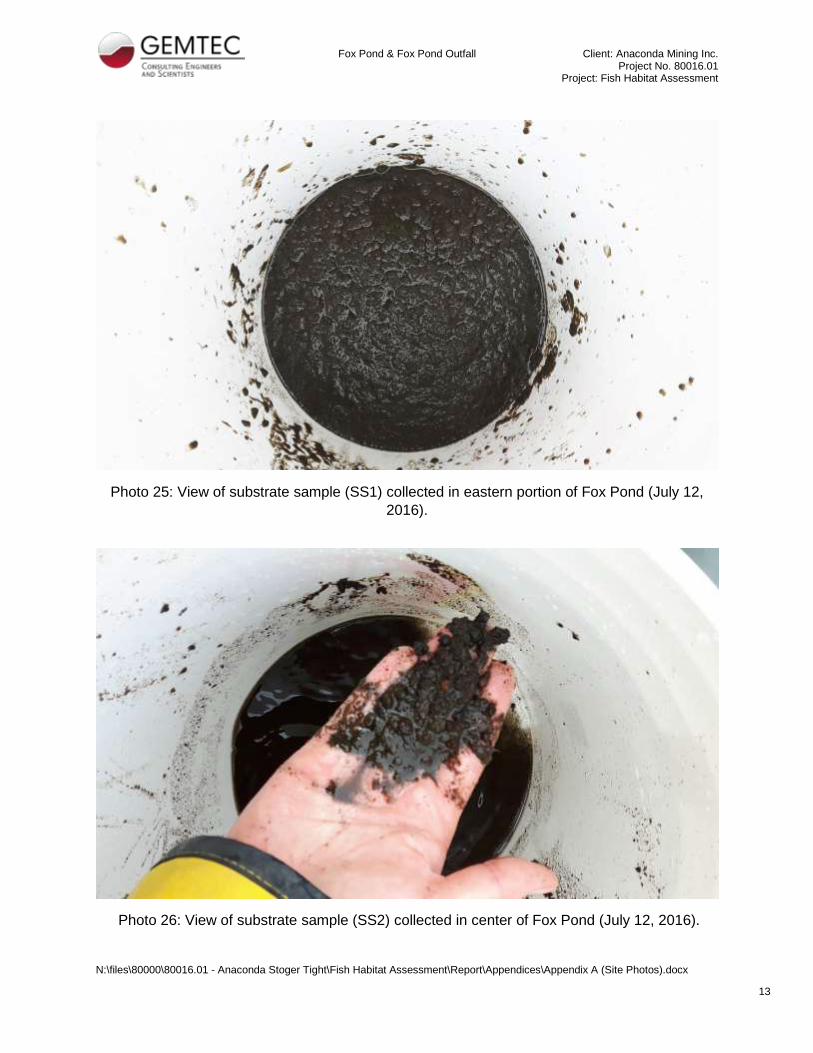
Fox Pond & Fox Pond Outfall Client: Anaconda Mining Inc. Project No. 80016.01
Project: Fish Habitat Assessment
N:\files\80000\80016.01 - Anaconda Stoger Tight\Fish Habitat Assessment\Report\Appendices\Appendix A (Site Photos).docx
14
Photo 27: View of substrate sample (SS5) collected in northwestern portion of Fox Pond (July
12, 2016).
Photo 28: View of substrate transition (SS8) along northwestern bank of Fox Pond (July 12,
2016).

Fox Pond & Fox Pond Outfall Client: Anaconda Mining Inc. Project No. 80016.01
Project: Fish Habitat Assessment
N:\files\80000\80016.01 - Anaconda Stoger Tight\Fish Habitat Assessment\Report\Appendices\Appendix A (Site Photos).docx
15
Photo 29: View of substrate sample (SS7) collected in the northeastern portion of Fox Pond
(July 13, 2016).
Photo 30: View of substrate sample (SS10) collected in the southern portion of Fox Pond (July
13, 2016).

Fox Pond & Fox Pond Outfall Client: Anaconda Mining Inc. Project No. 80016.01
Project: Fish Habitat Assessment
N:\files\80000\80016.01 - Anaconda Stoger Tight\Fish Habitat Assessment\Report\Appendices\Appendix A (Site Photos).docx
16
Photo 31: Substrate sample (SS11) in the south eastern portion of Fox Pond (July 13, 2016).
Photo 32: Brook Trout captured in the Outfall minnow net (July 12, 2016).

Fox Pond & Fox Pond Outfall Client: Anaconda Mining Inc. Project No. 80016.01
Project: Fish Habitat Assessment
N:\files\80000\80016.01 - Anaconda Stoger Tight\Fish Habitat Assessment\Report\Appendices\Appendix A (Site Photos).docx
17
Photo 33: Brook Trout captured in the un-baited fyke net (July 12, 2016).
Photo 34: Brook Trout captured in baited fyke net (July 13, 2016).

Fox Pond & Fox Pond Outfall Client: Anaconda Mining Inc. Project No. 80016.01
Project: Fish Habitat Assessment
N:\files\80000\80016.01 - Anaconda Stoger Tight\Fish Habitat Assessment\Report\Appendices\Appendix A (Site Photos).docx
18
Photo 35: One of two Brook Trout caught in baited fyke net (July 14, 2016).
Photo 36: Beaver berm at Fox Pond Outfall (July 11, 2016).

Fox Pond & Fox Pond Outfall Client: Anaconda Mining Inc. Project No. 80016.01
Project: Fish Habitat Assessment
N:\files\80000\80016.01 - Anaconda Stoger Tight\Fish Habitat Assessment\Report\Appendices\Appendix A (Site Photos).docx
19
Photo 37: Outfall channel downstream of beaver berm (July 11, 2016).
Photo 38: Open-water wetland along Fox Pond Outfall (July 11, 2016).

Fox Pond & Fox Pond Outfall Client: Anaconda Mining Inc. Project No. 80016.01
Project: Fish Habitat Assessment
N:\files\80000\80016.01 - Anaconda Stoger Tight\Fish Habitat Assessment\Report\Appendices\Appendix A (Site Photos).docx
20
Photo 39: Beaver berm downstream of open-water wetland along Fox Pond Outfall (July 11,
2016).
Photo 40: View of rock channel along the Fox Pond Outfall (July 11, 2016).
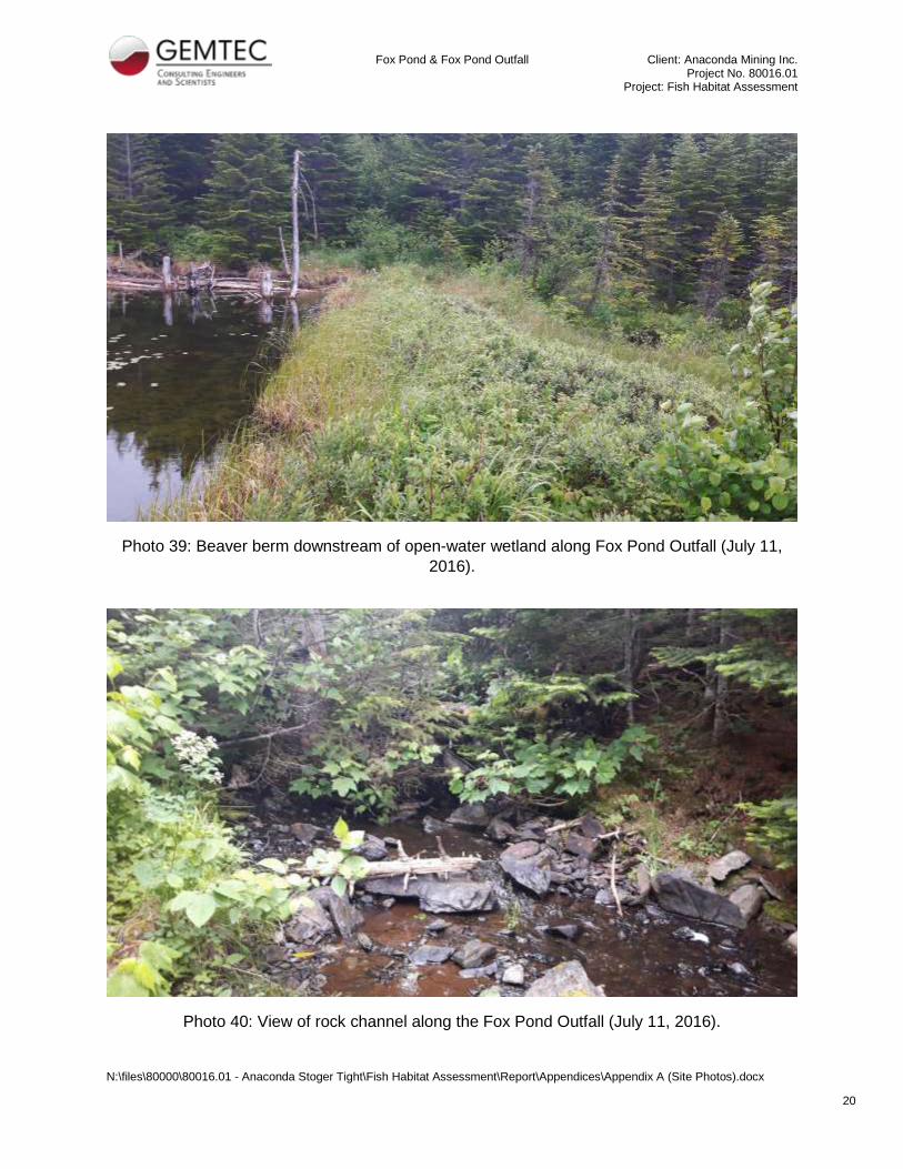
Fox Pond & Fox Pond Outfall Client: Anaconda Mining Inc. Project No. 80016.01
Project: Fish Habitat Assessment
N:\files\80000\80016.01 - Anaconda Stoger Tight\Fish Habitat Assessment\Report\Appendices\Appendix A (Site Photos).docx
21
Photo 41: Natural fish passage barriers in the rock channel along Fox Pond Outfall (July 11,
2016).

Fox Pond & Fox Pond Outfall Client: Anaconda Mining Inc. Project No. 80016.01
Project: Fish Habitat Assessment
N:\files\80000\80016.01 - Anaconda Stoger Tight\Fish Habitat Assessment\Report\Appendices\Appendix A (Site Photos).docx
22
Photo 42: Man-made drainage channel entering Fox Pond Outfall (July 11, 2016).
Photo 43: Grass wetland along Fox Pond Outfall. Beaver berm visible in the background (July
11, 2016).

Fox Pond & Fox Pond Outfall Client: Anaconda Mining Inc. Project No. 80016.01
Project: Fish Habitat Assessment
N:\files\80000\80016.01 - Anaconda Stoger Tight\Fish Habitat Assessment\Report\Appendices\Appendix A (Site Photos).docx
23
Photo 44: View of Fox Pond Outfall discharging into Camp Pond (July 11, 2016).
Photo 45: Brook Trout caught via electrofishing in the Fox Pond Outfall (July 13, 2016).

Fox Pond & Fox Pond Outfall Client: Anaconda Mining Inc. Project No. 80016.01
Project: Fish Habitat Assessment
N:\files\80000\80016.01 - Anaconda Stoger Tight\Fish Habitat Assessment\Report\Appendices\Appendix A (Site Photos).docx
24
Photo 46: Brook Trout caught via electrofishing in the Fox Pond Outfall (July 13, 2016).

Appendix B
Species at Risk Information

21/06/2016 RE: New Data Request: 20160615 19:54:07
http://fredericton.gemtec.ca:8888/Main/frmMessagePrint.aspx?popup=true&messageid=10247&folder=Inbox&user=jennifer.nicholson&domain=gemtec.ca&map… 1/4
RE: New Data Request: 2016‐06‐15 19:54:07
Tue 21/06/2016 11:28From: Durocher, AdamTo: [email protected]
Hi Jennifer,
Aက�ached are the species at risk data request results for your site at Fox Pond in Ming’s Bight, Newfoundland andLabrador.
Summary: Within your study area, there were no rare animal or rare plant records found. In the case of zero resultdata requests, there is no charge for the work.
Secondly, a new addi퀀ကon to our standard data requests is the use of Expert Opinion Maps. These maps are the resultof our work with species‐specific experts to gather sugges퀀ကons about loca퀀ကons where species at risk ‐ eitherprovincially, SARA or COSEWIC listed ‐ may be found. While we don't have observa퀀ကons in our database for thesespecies within your study area, our Expert Opinion Maps suggest that Banded Killifish, Ivory Gulls, Mountain HollyFern, Red Crossbills and Rusty Blackbirds are possible, while Polar Bears in the spring & summer, Boreal Felt Lichen,Short‐eared Owls and Newfoundland Marten are possible, but unlikely in your area. Your area is also said to be withinthe Barrow’s Goldeneye’s range.
For more informa퀀ကon, including a map absent of rare fauna/flora loca퀀ကons for your area, please refer to the followingaက�ached document:
Map.jpg ‐ shows the loca퀀ကon of the 5 km buffer around your site in Ming’s Bight.
Please do not hesitate to contact me if you have any ques퀀ကons.
Adam Durocher
Data Manager
Atlan퀀ကc Canada Conserva퀀ကon Data Centre
Corner Brook, NL
709‐637‐2494

21/06/2016 RE: New Data Request: 20160615 19:54:07
http://fredericton.gemtec.ca:8888/Main/frmMessagePrint.aspx?popup=true&messageid=10247&folder=Inbox&user=jennifer.nicholson&domain=gemtec.ca&map… 2/4
DATA SOURCES:
All data housed at Atlan퀀ကc Canada Conserva퀀ကon Data Centre (ACCDC). Refer to the ‘CITATION’ field for data sources.
‐‐‐‐‐‐‐‐‐‐‐‐‐‐‐‐‐‐‐‐‐‐‐‐‐‐‐‐‐‐‐‐‐‐‐‐‐‐‐‐‐‐‐‐‐‐‐‐‐‐‐‐‐‐‐‐‐‐‐‐‐‐‐‐‐‐‐‐‐‐‐‐‐‐‐‐‐‐‐‐‐‐‐‐‐‐‐‐‐‐‐‐‐‐‐‐‐‐‐‐‐‐‐‐‐‐‐‐‐‐‐‐‐‐‐‐‐‐‐‐‐‐‐‐‐‐‐‐‐‐‐‐‐‐‐‐‐‐‐‐‐‐‐‐‐‐‐‐
CAVEATS:
ACCDC rare taxa occurrence records are offered as a guide recognizing that the ability to find plants and animals will depend upon the season. The ACCDC makes a strong effort to verify the accuracy of all the data it obtains, generates and manages, but it will not be held responsible forinaccuracies in data that it provides.
‐‐‐‐‐‐‐‐‐‐‐‐‐‐‐‐‐‐‐‐‐‐‐‐‐‐‐‐‐‐‐‐‐‐‐‐‐‐‐‐‐‐‐‐‐‐‐‐‐‐‐‐‐‐‐‐‐‐‐‐‐‐‐‐‐‐‐‐‐‐‐‐‐‐‐‐‐‐‐‐‐‐‐‐‐‐‐‐‐‐‐‐‐‐‐‐‐‐‐‐‐‐‐‐‐‐‐‐‐‐‐‐‐‐‐‐‐‐‐‐‐‐‐‐‐‐‐‐‐‐‐‐‐‐‐‐‐‐‐‐‐‐‐‐‐‐‐‐
PLEASE NOTE:
* ACCDC data is restricted for use by the specified data user only; any third party requiring data must make its own request to the ACCDC.
* Specified data users may not publish any informa퀀ကon provided by the ACCDC or its partners without prior permission.
* To ensure the currency of the data, the ACCDC requires Data Users to destroy all copies of data 18 months aer the date of receipt.
* ACCDC data reports are restricted to that data in our Data System at the 퀀ကme of the request.
* Data accuracy is qualified as to loca퀀ကon (Accuracy) and 퀀ကme (Date)
* ACCDC data reports are not to be constructed as exhaus퀀ကve inventories of taxa in an area.
* The non‐occupancy of a taxon cannot be inferred by its absence in an ACCDC data report.
* Museum databases, which are the basis for more accessible public databases, such as those of the ACCDC, are works in progress. Essen퀀ကally,they are finding aids and dynamic data records, constructed primarily to serve scien퀀ကsts engaged in the con퀀ကnuing, ac퀀ကve process of plantsystema퀀ကcs and taxonomy. Ongoing addi퀀ကons of new collec퀀ကons, and frequent upgrades to the iden퀀ကfica퀀ကons of all plant specimens housed inmuseum herbaria, may not always be reflected, in real 퀀ကme, by databases such as those of the ACCDC. Specifically, the conserva퀀ကon status ofindividual species recorded in the ACCDC database may not be absolutely current. It is therefore the responsibility of the data user to contactthe relevant museums directly, in order to check for the most current iden퀀ကfica퀀ကons of specimens of interest, and to ascertain from thescien퀀ကsts concerned, their current understanding of the conserva퀀ကon status of individual species in ques퀀ကon. The absolute conserva퀀ကon statusof any given species is dynamic, and subject to change over short periods of 퀀ကme.
From: James Churchill (AC CDC) [mailto:[email protected]] Sent: Thursday, June 16, 2016 8:49 AMTo: Durocher, AdamSubject: Fwd: New Data Request: 20160615 19:54:07

21/06/2016 RE: New Data Request: 20160615 19:54:07
http://fredericton.gemtec.ca:8888/Main/frmMessagePrint.aspx?popup=true&messageid=10247&folder=Inbox&user=jennifer.nicholson&domain=gemtec.ca&map… 3/4
Forwarded message From: Apache <[email protected]>Date: Wed, Jun 15, 2016 at 4:54 PMSubject: New Data Request: 20160615 19:54:07To: [email protected]
New Data Request:
name: Jennifer Nicholsoncompany: GEMTEC Limitedphone: 5064766176email: email2:jobnum: 80016.01area: Fox Pond, Ming's Bight, NFLDdetails: Fish Habitat Surveylat: 49.967644lon: 56.076170comment:asap: standard
..........................................................................
UPDATES (www.accdc.com/en/updates.html (http://www.accdc.com/en/updates.html) )
December 23, 2015. Database release 151223 and SRANK updates(http://www.accdc.com/en/updates.html#Dec2015)
November 12, 2015. Updates to 100 km species lists (Data Report Section 5.0)(http://www.accdc.com/en/updates.html#Nov2015)

21/06/2016 RE: New Data Request: 20160615 19:54:07
http://fredericton.gemtec.ca:8888/Main/frmMessagePrint.aspx?popup=true&messageid=10247&folder=Inbox&user=jennifer.nicholson&domain=gemtec.ca&map… 4/4
July, 2015. Updated Data Request Cost Structure (http://www.accdc.com/en/updates.html#Jul2015)
June 10, 2015. NEW Submit Data Requests online (http://www.accdc.com/en/updates.html#Jun2015)
June 10, 2015. Our new website is live! (http://www.accdc.com/en/updates.html#Jun2015) May, 2014. Location Sensitive Species (Data Report Section 4.3)(http://www.accdc.com/en/updates.html#May2015)
..........................................................................
James ChurchillData ManagerAtlantic Canada Conservation Data Centre (AC CDC)[email protected]: (902) 6796146
..........................................................................
“This email and any attached 擽ῠiles are intended for the sole use of the primary and copied addressee(s) and may contain privilegedand/or con擽ῠidential information. Any distribution, use or copying by any means of this information is strictly prohibited. If you receivedthis email in error, please delete it immediately and notify the sender.”
Attachments:
image002.jpgMap.jpg


Appendix B:
Species at Risk Study
Client: Anaconda Mining Inc.
Project Number: 80016.01
Project: Fish Habitat Survey - Fox Pond
Common Name Scientific Name COSEWIC SARA NFLD SAR
Mountain Holly Fern Polystichum scopulinum Threatened Threatened -
Boreal Felt Lichen Erioderma pedicellatum Special
Concern
Special
Concern Vulnerable
Banded Killfish Fundulus diaphanus Special
Concern
Special
Concern Vunerable
Ivory Gulls Pagophila eburnea Endangered Endangered Endangered
Red Crossbills Loxia curvirostra percna Threatened Endangered Endangered
Rusty Blackbird Euphagus carolinus Special
Concern
Special
Concern Vulnerable
Polar Bears Ursus maritimusSpecial
Concern
Special
Concern Vulnerable
Short-eared Owl Asio flammeusSpecial
Concern
Special
Concern Vulnerable
Newfoundland Marten Martes americana atrata Threatened Threatened Threatened
Barrow's Goldeneye Bucephala islandicaSpecial
Concern
Special
Concern Vulnerable
TABLE B1: SPECIES HABITAT COMPARISON
Flora
Fauna
N:\files\80000\80016.01 - Anaconda Stoger Tight\Fish Habitat Assessment\Report\Appendices\Appendix B (NL-CDC Information)\Appendix B3-4 (Habitats Comparision).xlsx

Appendix B:
Species at Risk Study
Client: Anaconda Mining Inc.
Project Number: 80016.01
Project: Fish Habitat Survey - Fox Pond
Common Name Scientific Name Prefered HabitatHabitat
Present
Flora
Mountain Holly Fern Polystichum scopulinum
In North America, Mountain Holly Fern grows in a specialized habitat consisting of shallow soil with a high concentration of heavy metals over a
substrate of rocks containing iron and magnesium silicate (ultramafic rocks), mainly olivine and serpentine. The population on the island of
Newfoundland was recorded in 1950 from the Humber West area (North Arm Mountain) in the western part of the island and occurred on the
southerly slopes of a serpentine ridge.
N
Boreal Felt Lichen Erioderma pedicellatum
Currently believed to exist only in Canada with two disjunct populations: the boreal population (the island of Newfoundland) and the Atlantic
population (Nova Scotia and New Brunswick). The boreal population of the lichen is known from a total of 94 existing and historical sites scattered
across the western and southern regions of the island of Newfoundland. Typical habitat for the Boreal Felt Lichen is northerly exposed forested slopes
where cool and moist conditions prevail throughout most of the year. These mature forest sites are also rich in moisture-loving species such as
sphagnum mosses and Cinnamon Fern. In well-lit forests, the Boreal Felt Lichen is found predominantly on tree trunks' whereas in more shaded
habitats it is found mostly on branches.
Y
Banded Killfish Fundulus diaphanus
There are seven known sites for the Newfoundland population of Banded Killifish. The majority of these sites are coastal, in the southwestern portion
of the island, although one site is inland, in the Indian Bay watershed of northeastern Newfoundland. Banded Killifish in Newfoundland tend to
frequent quiet areas of clear lakes and ponds with a muddy or sandy bottom. For spawning, they depend on warm water where there is abundant
submerged aquatic vegetation and considerable detritus. Although this type of habitat is abundant in Newfoundland watersheds, the species occurs
only in very restricted areas of one or two of the lakes in the watersheds it occupies. It cannot use inland waters where there are barriers to
migration, such as rivers with steep gradients; however, the Banded Killifish does not occur in habitats that meet the understood criteria and that
appear to be accessible to existing populations.
N
Barrow's Goldeneye Bucephala islandica
Data indicate that it breeds only in Canada with the only confirmed breeding records are from Quebec. Small numbers of this population winter in the
Maritime Provinces and along the northern Atlantic coastline in the United States. In Quebec, the eastern population inhabits the balsam fir-white
birch forest regions of the province. More specifically, birds appear to be restricted to small, high elevation lakes north of the St. Lawrence Estuary
and Gulf. During the non-breeding season, the species spends time in the coastal waters of the Estuary and Gulf.
N
Ivory Gulls Pagophila eburneaIn Canada, the species breeds exclusively in Nunavut. Wintering occasionally along the eastern coasts of Newfoundland and Labrador, particularly the
Great Northern Peninsula of Newfoundland. Outside the breeding season, Ivory Gulls live near the edges of pack ice or drift ice.N
Newfoundland Marten Martes americana atrata
The atrata subspecies of the American Marten is found in Canada, on the island of Newfoundland and in northern Quebec and Labrador. The
Newfoundland population occurs only on the island of Newfoundland. The Newfoundland population of the American Marten is currently found in three
main forest patches in western Newfoundland (Little Grand Lake, Red Indian Lake and Main River) and on the east coast of Newfoundland (Terra Nova
National Park of Canada). Smaller populations occur in peripheral areas near St. George’s and Lobster House Hill. Newfoundland Marten prefer mature
(old growth) coniferous and mixed-wood forests and coniferous forests of varying ages. Martens require dense overhead cover, coarse woody debris,
shrubs, and trees with low-hanging branches.
Y
Polar Bears Ursus maritimus
In Canada, the species is found in ice-covered regions from Yukon and the Bering Sea in the west to Newfoundland and Labrador in the east and from
northern Ellesmere Island south to James Bay. The bears are found mainly in the coastal regions of the Arctic Ocean and in the channels between the
islands. The Polar Bear frequents the southern edge of the multi-year pack ice of the Arctic Ocean (the ice-covered waters surrounding the North
Pole). It is commonly found in coastal areas and in the channels between the islands and archipelagos of the Arctic.
N
Red Crossbills Loxia curvirostra percna
Red Crossbills are highly specialized for conifer habitats. Unlogged or mature forests that produce abundant cones are this bird’s preferred habitat.
Habitats that furnish the Red Crossbill percna subspecies with conifer seeds are large, mature black spruce and balsam fir stands and, on smaller
scales throughout the island, red pine, white pine, and white spruce stands. In addition to foraging in these stands, the bird also roosts and nests
there; however, the foraging sites can be distant from the roosting and nesting sites. Because thissubspecies is hard to identify in the field, it is not
certain that all of the Red Crossbills observed in Newfoundland have in fact been of the rare percna subspecies.
Y
Rusty Blackbird Euphagus carolinus
The Rusty Blackbird nests in the boreal forest and favours the shores of wetlands such as slow-moving streams, peat bogs, marshes, swamps, beaver
ponds and pasture edges. In wooded areas, the Rusty Blackbird only rarely enters the forest interior. During the winter, the Rusty Blackbird mainly
frequents damp forests and, to a lesser extent, cultivated fields.
Y
Short-eared Owl Asio flammeus
In North America, it breeds sporadically in arctic areas, coastal marshes and interior grasslands, where voles and other small rodents proliferate. The
Short-eared Owl makes use of a wide variety of open habitats, including arctic tundra, grasslands, peat bogs, marshes, sand-sage concentrations and
old pastures. It also occasionally breeds in agricultural fields. Preferred nesting sites are dense grasslands, as well as tundra with areas of small
willows. While the Short-eared Owl has a marked preference for open spaces, the main factor influencing the choice of its local habitat is believed to
be the abundance of food, in both summer and winter.
N
* Habitat information obtained from Species at Risk Public Registry (SARA, 2016).
TABLE B2: SPECIES HABITAT COMPARISON
Fauna
N:\files\80000\80016.01 - Anaconda Stoger Tight\Fish Habitat Assessment\Report\Appendices\Appendix B (NL-CDC Information)\Appendix B3-4 (Habitats Comparision).xlsx

Appendix C
Stream Assessment Forms


Appendix D
Water Quality Results

Appendix D:
Water Quality Results
Client: Ananconda Mining Inc.
Project Number: 80016.01
Project:Fish Habitat Survey - Fox Pond
Sample SiteTemperature
(°C)
Conductivity
(µS/cm)
Dissolved
Oxygen (mg/L)pH Sample Site
Depth
(m)Temperature (°C)
Conductivity
(µS/cm)
Dissolved
Oxygen (mg/L)pH
FP1 17.49 104 9.33 8.6 0.91 17.47 103 9.48 7.96
FP2 17.52 104 9.08 8.13 1.37 15.72 98 9.34 8.02
FP3 17.47 103 9.23 8 0.91 17.37 103 9.35 7.6
FP4 17.47 103 9.48 7.96 2.44 16.69 102 9.49 7.77
FP5 17.02 102 9.72 7.93 3.96 16.1 103 9.48 7.79
FP6 17.97 102 9.84 7.94 5.49 16.22 104 9.67 7.72
FP7 17.51 103 9.66 7.93 7.01 7.84 105 9.01 8.04
FP8 17.52 103 9.56 7.91 8.53 (bottom) 8.02 105 8.73 6.02
FP9 17.58 103 9.54 7.86
FP10 17.56 114 9.05 7.87 0.91 15.93 98 9.46 8.46
FP11 17.57 102 9.4 7.98 2.74 15.57 97 9.56 8.42
FP12 17.57 104 9.48 8.04 6.71 10.25 96 8.05 7.91
FP13 17.26 101 9.52 7.86 0.91 16.14 99 9.35 8.78
FP14 17.56 121 9.11 7.94 4.88 8.11 109 7.17 9.52
FP15 17.37 103 9.35 7.6 0.91 16.67 100 9.32 8.72
1.93 15.7 99 8.67 8.97FP16 16.84 101 9.83 8.26 2.44 (bottom) 14.86 114 7.52 9.1
FP17 16.35 99 9.81 8.45 *Note: All parameters were measured using a YSI 556 multimeter.
FP18 15.93 98 9.46 8.46
FP19 15.9 97 9.5 8.8
FP20 16.04 98 9.31 8.78
FP21 16.14 99 9.35 8.78
FP22 15.99 99 9.31 8.82
FP23 16.17 98 9.14 8.8
FP24 16.69 109 8.92 8.71
FP25 16.67 100 9.32 8.72FP26 15.66 98 9.28 9.08
Sample SiteTemperature
(°C)
Conductivity
(µS/cm)
Dissolved
Oxygen (mg/L)pH
FPO1 15.83 100 7.91 8.96
FPO2 14.06 101 7.77 8.49
FPO3 13.61 99 7.47 8.19
FPO4 13.09 98 7.33 8.07
FPO5 13.47 98 9.07 7.98
FPO6 13.52 96 8.98 7.94
FPO7 13.67 95 8.13 7.91
12-Jul-16
*Note: All parameters were measured using a YSI 556 multimeter.
Table D-2 Water Quality Results - Fox Pond Water Column
12-Jul-16
13-Jul-16
FP21
FP25
FP4
FP15
FP18
Table D-3 Water Quality Results - Fox Pond Outfall
11-Jul-16
13-Jul-16
Table D-1 Water Quality Results - Fox Pond
*Note: All parameters were measured using a YSI 556 multimeter submerged to a depth of 3 ft.
N:\files\80000\80016.01 - Anaconda Stoger Tight\Fish Habitat Assessment\Report\Appendices\Appendix D (Water Quality Results).xlsx

29 August, 2016 File: 80016.01
Anaconda Mining Inc.
238 Highway 410
Baie Verte, NL
A0K 1B0
Attention: Gordana Slepcev, P.Eng., M.Sc.
Manager of Technical Services
Re: Desktop Hydrological Assessment, Fox Pond and its Outflow Stog’er Tight Property, located near Ming’s Bight, Newfoundland
Existing Conditions GEMTEC Limited (GEMTEC) currently understands that water is exiting Fox Pond through a channel at an elevation of approximately 114m. Additionally, based on aerial photographs, it was assumed that the ground cover is primarily Woods with a class C soil category. This soil class was selected based on the understanding that there was a lot of rock in the area and would not absorb much water before becoming saturated. Topographic mapping was acquired and used to determine the existing watershed of the pond as well as the longest flow path. Finally IDF data was obtained for the Daniels Harbour IDF station in order to predict the flows for the various return periods. This station was used because it provided 15 years more data than La Scie which was the closest IDF station.
Calculations
In order to determine the time of concentration a number of methods were considered, however,
Kerpich was selected because it was developed for use on smaller drainage areas and also
returned the shortest time of concentration for a conservative calculation. Based on the slope,
flow path and length the time of concentration was estimated to be 22 minutes.
Using our HydroCAD software we were able to calculate the flows for the 2, 5, 10, 20, 25, 50
and 100 year return period storm. Using the Rational method the following flows were obtained:
Return Period 2 5 10 20 25 50 100
Flow Rate m3/s 1.792 2.536 3.026 3.502 3.652 4.111 4.567

Page 2 of 2
Please refer to the attached showing the watershed area, flow paths and HydroCAD results for
all return periods.
If you have any questions please feel free to contact us.
______________________________ Matt Nicholson, P. Eng. MGN
N:\files\80000\80016.01 - Anaconda Stoger Tight\Flow Rates\2016MN0804L1.doc

110.0
1
2
0
.
0
1
3
0
.
0
1
4
0
.
0
110.0
1
2
0
.
0
1
3
0
.0
1
4
0
.
0
1
5
0
.0
1
6
0
.
0
1
7
0
.
0
1
8
0
.
0
Drawing File No.
Scale
Drawing
Calculations By
Project
Drawn By
Date
Checked By
80016.01
MN
JJKMN
JULY, 2016
Checked By
JJK
D01 0
Revision No.
DESKTOP HYDROLOGICAL ASSESSMENT
FOX POND AND ITS OUTFLOW
MING'S BIGHT, NL
DRAINAGE AREA AND FLOW PATH
WATERSHED DRAINAGE AREA = 596,800 m
2
DRAINAGE PATH = 1076m
FOX POND
EXISTING POND OUTLET
(PUMPING POINT)
4002000
1:10000
600m
ESTIMATED FLOWS AT PUMPING
POINT:
2 YEAR: 1.792 m
3
/s
5 YEAR: 2.536 m
3
/s
10 YEAR: 3.026 m
3
/s
20 YEAR: 3.502 m
3
/s
25 YEAR: 3.652 m
3
/s
50 YEAR: 4.111 m
3
/s
100 YEAR: 4.567 m
3
/s

Daniels Harbour 2-Year Duration=22 min, Inten=21.8 mm/hrFox Pond Run off Printed 16/07/28Prepared by GEMTEC Limited
Page 1HydroCAD® 10.00 s/n 07190 © 2011 HydroCAD Software Solutions LLC
Summary for Subcatchment 1S: Fox Pond Outlet Flow
Runoff = 1.7918 m³/s @ 0.37 hrs, Volume= 2.384 Ml, Depth= 4 mm
Runoff by Rational method, Rise/Fall=1.0/1.0 xTc, Time Span= 0.00-3.00 hrs, dt= 0.01 hrsDaniels Harbour 2-Year Duration=22 min, Inten=21.8 mm/hr
Area (m²) C Description
98,600.0 1.00498,200.0 0.40 Woods, Poor, HSG C
596,800.0 0.50 Weighted Average498,200.0 83.48% Pervious Area98,600.0 16.52% Impervious Area
Tc Length Slope Velocity Capacity Description(min) (meters) (m/m) (m/sec) (m³/s)
22.0 Direct Entry,
Subcatchment 1S: Fox Pond Outlet Flow
Runoff
Hydrograph
Time (hours)3210
Flow
(m
³/s)
2
1
0
Daniels Harbour 2-YearDuration=22 min,Inten=21.8 mm/hr
Runoff Area=596,800.0 m²Runoff Volume=2.384 Ml
Runoff Depth=4 mmTc=22.0 min
C=0.50
1.7918 m³/s

Daniels Harbour 5-year Duration=22 min, Inten=30.8 mm/hrFox Pond Run off Printed 16/07/28Prepared by GEMTEC Limited
Page 2HydroCAD® 10.00 s/n 07190 © 2011 HydroCAD Software Solutions LLC
Summary for Subcatchment 1S: Fox Pond Outlet Flow
Runoff = 2.5356 m³/s @ 0.37 hrs, Volume= 3.374 Ml, Depth= 6 mm
Runoff by Rational method, Rise/Fall=1.0/1.0 xTc, Time Span= 0.00-3.00 hrs, dt= 0.01 hrsDaniels Harbour 5-year Duration=22 min, Inten=30.8 mm/hr
Area (m²) C Description
98,600.0 1.00498,200.0 0.40 Woods, Poor, HSG C
596,800.0 0.50 Weighted Average498,200.0 83.48% Pervious Area98,600.0 16.52% Impervious Area
Tc Length Slope Velocity Capacity Description(min) (meters) (m/m) (m/sec) (m³/s)
22.0 Direct Entry,
Subcatchment 1S: Fox Pond Outlet Flow
Runoff
Hydrograph
Time (hours)3210
Flow
(m
³/s)
2
1
0
Daniels Harbour 5-yearDuration=22 min,Inten=30.8 mm/hr
Runoff Area=596,800.0 m²Runoff Volume=3.374 Ml
Runoff Depth=6 mmTc=22.0 min
C=0.50
2.5356 m³/s

Daniels Harbour 10-year Duration=22 min, Inten=36.8 mm/hrFox Pond Run off Printed 16/07/28Prepared by GEMTEC Limited
Page 3HydroCAD® 10.00 s/n 07190 © 2011 HydroCAD Software Solutions LLC
Summary for Subcatchment 1S: Fox Pond Outlet Flow
Runoff = 3.0260 m³/s @ 0.37 hrs, Volume= 4.026 Ml, Depth= 7 mm
Runoff by Rational method, Rise/Fall=1.0/1.0 xTc, Time Span= 0.00-3.00 hrs, dt= 0.01 hrsDaniels Harbour 10-year Duration=22 min, Inten=36.8 mm/hr
Area (m²) C Description
98,600.0 1.00498,200.0 0.40 Woods, Poor, HSG C
596,800.0 0.50 Weighted Average498,200.0 83.48% Pervious Area98,600.0 16.52% Impervious Area
Tc Length Slope Velocity Capacity Description(min) (meters) (m/m) (m/sec) (m³/s)
22.0 Direct Entry,
Subcatchment 1S: Fox Pond Outlet Flow
Runoff
Hydrograph
Time (hours)3210
Flow
(m
³/s)
3
2
1
0
Daniels Harbour 10-yearDuration=22 min,Inten=36.8 mm/hr
Runoff Area=596,800.0 m²Runoff Volume=4.026 Ml
Runoff Depth=7 mmTc=22.0 min
C=0.50
3.0260 m³/s

Daniels Harbour 20-year Duration=22 min, Inten=42.6 mm/hrFox Pond Run off Printed 16/07/28Prepared by GEMTEC Limited
Page 4HydroCAD® 10.00 s/n 07190 © 2011 HydroCAD Software Solutions LLC
Summary for Subcatchment 1S: Fox Pond Outlet Flow
Runoff = 3.5021 m³/s @ 0.37 hrs, Volume= 4.659 Ml, Depth= 8 mm
Runoff by Rational method, Rise/Fall=1.0/1.0 xTc, Time Span= 0.00-3.00 hrs, dt= 0.01 hrsDaniels Harbour 20-year Duration=22 min, Inten=42.6 mm/hr
Area (m²) C Description
98,600.0 1.00498,200.0 0.40 Woods, Poor, HSG C
596,800.0 0.50 Weighted Average498,200.0 83.48% Pervious Area98,600.0 16.52% Impervious Area
Tc Length Slope Velocity Capacity Description(min) (meters) (m/m) (m/sec) (m³/s)
22.0 Direct Entry,
Subcatchment 1S: Fox Pond Outlet Flow
Runoff
Hydrograph
Time (hours)3210
Flow
(m
³/s)
3
2
1
0
Daniels Harbour 20-yearDuration=22 min,Inten=42.6 mm/hr
Runoff Area=596,800.0 m²Runoff Volume=4.659 Ml
Runoff Depth=8 mmTc=22.0 min
C=0.50
3.5021 m³/s

Daniels Harbour 25-year Duration=22 min, Inten=44.4 mm/hrFox Pond Run off Printed 16/07/28Prepared by GEMTEC Limited
Page 5HydroCAD® 10.00 s/n 07190 © 2011 HydroCAD Software Solutions LLC
Summary for Subcatchment 1S: Fox Pond Outlet Flow
Runoff = 3.6515 m³/s @ 0.37 hrs, Volume= 4.858 Ml, Depth= 8 mm
Runoff by Rational method, Rise/Fall=1.0/1.0 xTc, Time Span= 0.00-3.00 hrs, dt= 0.01 hrsDaniels Harbour 25-year Duration=22 min, Inten=44.4 mm/hr
Area (m²) C Description
98,600.0 1.00498,200.0 0.40 Woods, Poor, HSG C
596,800.0 0.50 Weighted Average498,200.0 83.48% Pervious Area98,600.0 16.52% Impervious Area
Tc Length Slope Velocity Capacity Description(min) (meters) (m/m) (m/sec) (m³/s)
22.0 Direct Entry,
Subcatchment 1S: Fox Pond Outlet Flow
Runoff
Hydrograph
Time (hours)3210
Flow
(m
³/s)
4
3
2
1
0
Daniels Harbour 25-yearDuration=22 min,Inten=44.4 mm/hr
Runoff Area=596,800.0 m²Runoff Volume=4.858 Ml
Runoff Depth=8 mmTc=22.0 min
C=0.50
3.6515 m³/s

Daniels Harbour 50-year Duration=22 min, Inten=50.0 mm/hrFox Pond Run off Printed 16/07/28Prepared by GEMTEC Limited
Page 6HydroCAD® 10.00 s/n 07190 © 2011 HydroCAD Software Solutions LLC
Summary for Subcatchment 1S: Fox Pond Outlet Flow
Runoff = 4.1108 m³/s @ 0.37 hrs, Volume= 5.469 Ml, Depth= 9 mm
Runoff by Rational method, Rise/Fall=1.0/1.0 xTc, Time Span= 0.00-3.00 hrs, dt= 0.01 hrsDaniels Harbour 50-year Duration=22 min, Inten=50.0 mm/hr
Area (m²) C Description
98,600.0 1.00498,200.0 0.40 Woods, Poor, HSG C
596,800.0 0.50 Weighted Average498,200.0 83.48% Pervious Area98,600.0 16.52% Impervious Area
Tc Length Slope Velocity Capacity Description(min) (meters) (m/m) (m/sec) (m³/s)
22.0 Direct Entry,
Subcatchment 1S: Fox Pond Outlet Flow
Runoff
Hydrograph
Time (hours)3210
Flow
(m
³/s)
4
3
2
1
0
Daniels Harbour 50-yearDuration=22 min,Inten=50.0 mm/hr
Runoff Area=596,800.0 m²Runoff Volume=5.469 Ml
Runoff Depth=9 mmTc=22.0 min
C=0.50
4.1108 m³/s

Daniels Harbour 100-year Duration=22 min, Inten=55.5 mm/hrFox Pond Run off Printed 16/07/28Prepared by GEMTEC Limited
Page 7HydroCAD® 10.00 s/n 07190 © 2011 HydroCAD Software Solutions LLC
Summary for Subcatchment 1S: Fox Pond Outlet Flow
Runoff = 4.5672 m³/s @ 0.37 hrs, Volume= 6.077 Ml, Depth= 10 mm
Runoff by Rational method, Rise/Fall=1.0/1.0 xTc, Time Span= 0.00-3.00 hrs, dt= 0.01 hrsDaniels Harbour 100-year Duration=22 min, Inten=55.5 mm/hr
Area (m²) C Description
98,600.0 1.00498,200.0 0.40 Woods, Poor, HSG C
596,800.0 0.50 Weighted Average498,200.0 83.48% Pervious Area98,600.0 16.52% Impervious Area
Tc Length Slope Velocity Capacity Description(min) (meters) (m/m) (m/sec) (m³/s)
22.0 Direct Entry,
Subcatchment 1S: Fox Pond Outlet Flow
Runoff
Hydrograph
Time (hours)3210
Flow
(m
³/s)
5
4
3
2
1
0
Daniels Harbour 100-yearDuration=22 min,Inten=55.5 mm/hr
Runoff Area=596,800.0 m²Runoff Volume=6.077 Ml
Runoff Depth=10 mmTc=22.0 min
C=0.50
4.5672 m³/s
