remote sensing and geographical information...
TRANSCRIPT
REMOTE SENSING AND GEOGRAPHICAL INFORMATION SYSTEMS APPLICATIONS TO DETERMINE GRASSLAND TYPES
AND GRAZING SYSTEMS IN HIGHLANDS OF THE EASTERN TURKEY
Y. BOZKURT1 , L. BASAYIGIT 1 and I. KAYA2
1 Suleyman Demirel University, Faculty of Agriculture, Department of Animal Science, Isparta, TURKEY, [email protected]
2 Kafkas University, Faculty of Veterinary Medicine, Department of Animal Science, Kars, TURKEY
SESSION 38-9

Remote sensing (RS) is the science ofobtaining and interpreting information froma distance, using sensors that are not inphysical contact with the object beingobserved.
In its broadest sense includes aerial, satellite,and spacecraft observations of the surfacesand atmospheres of the planets in our solarsystem.
INTRODUCTION
A geographic information system (GIS) is asystem for capturing, storing, analyzing andmanaging data and associated attributeswhich are spatially referenced to the earth.
It is a computer system capable ofintegrating, storing, editing, analyzing,sharing, and displaying geographically-referenced information.
INTRODUCTION...
Integration of these technologies has been reportedto be used in many areas of agriculture as well,especially for land use and grassland management.
Excessive grazing of pastures and meadows andincorrect land utilisation are major causes ofdepletion of grazing land which is a critical resourcefor animal production.
For this reason determination of grazing pressurebecomes very important issue for effective grazingmanagement.
INTRODUCTION...
Therefore,Therefore, itit waswas aimedaimed toto determinedetermine thethegrasslandgrassland typestypes andand grazinggrazing systemssystems usingusingLANDSATLANDSAT satellitesatellite imagesimages andand toto evaluateevaluategrasslandgrassland qualityquality usingusing GISGIS andand RSRS techniquestechniques..
OBJECTIVE

Study site
Study area covered provincial boundaries of Kars.
The area of Kars province is 918.117 ha.
It lies between 260 000-390 000 km East, 4 420 000 -4 530 000 km North according to UTM GeographicCoordinate System.
Ardahan province is in the North; Agri in the South;Erzurum in the West and Armenia in the East.
MATERIALS and METHODS

MATERIALS and METHODS...
Geographical location of the study areaGeographical location of the study area
MATERIALS and METHODS...Study site..
The grasslands account for 27.9% of all area of Turkey.This is equivalent of 21 million ha. In general, the animalhusbandry is carried out under extensive conditions andbased on grasslands in the Eastern part of Turkey whereKars Province is located and 41.4% of the wholegrassland area of the country is present.
Kars province has a unique place in the region in termsof both the number of cattle and sheep and the largerarea of grassland available.

MATERIALS and METHODS...Data use
In this study, the mapshowing currrent status ofgrasslands from theLANDSAT 5 TM satellitedata with 171 path and 32row number taken on wasproduced.
Unprocessed satelite image of the study area.Unprocessed satelite image of the study area.
Determination of Current status of Grassland
To determine the current status of grasslands,red (0.45-0.52 µm), near infrared (0.52-0.60µm) and infrared (0.63-0.69 µm) bands ofimages were used and unsupervisedclassification was applied and the distributionmap of grasslands showing the present statuswas produced.
MATERIALS and METHODS...
Determination of Current status of Grassland
• In this image, the units showing differentreflections were separated from each otherby using histogram equalisation process. Asa result of interpretation of histograms andhistogram equalisation process, 11 basicplant cover types were determined andsatellite data were classified into 11 classesaccording to unsupervised-isodata method.
MATERIALS and METHODS...
Determination of Current status of Grassland
The each of these classes was checked outin the study area. Each class was confirmedat least at 5 locations at differentphysiographs. Finally, water suface, forestcover, agricultural land, urban and 8different grassland types with differentdevelopment were determined. Thegrassland distribution of the study area wascreated by merging 8 different grasslandtypes.
MATERIALS and METHODS...
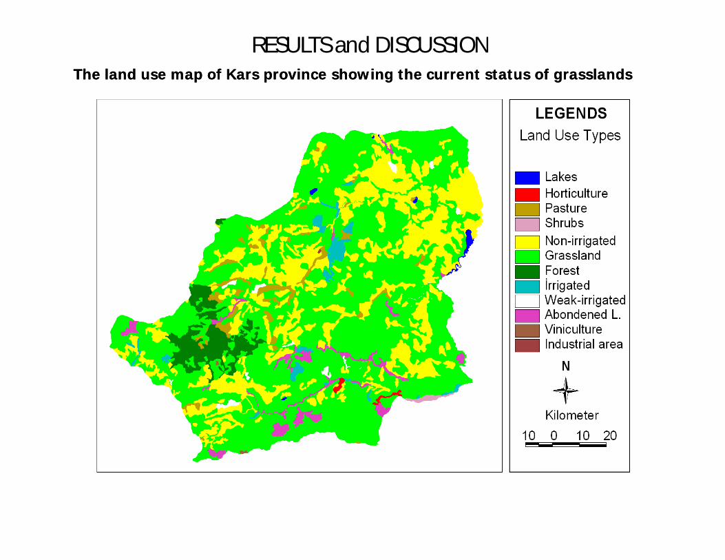
RESULTS and DISCUSSIONThe land use map of Kars province showing the current status of grasslandsThe land use map of Kars province showing the current status of grasslands
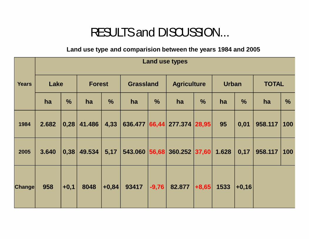
RESULTS and DISCUSSION...Land use type and comparision between the years 1984 and 2005
Years
Land use types
Lake Forest Grassland Agriculture Urban TOTAL
ha % ha % ha % ha % ha % ha %
1984 2.682 0,28 41.486 4,33 636.477 66,44 277.374 28,95 95 0,01 958.117 100
2005 3.640 0,38 49.534 5,17 543.060 56,68 360.252 37,60 1.628 0,17 958.117 100
Change 958 +0,1 8048 +0,84 93417 -9,76 82.877 +8,65 1533 +0,16

RESULTS and DISCUSSIONThe digitised land use and grassland classificatin map
RESULTS and DISCUSSION
• It was found that 2/3 rd of the total area of Kars province isgrassland. However, in terms of plant cover density thisaccounts for only 1/3 rd of the total area. In other words, only181 275.7 ha of the total of 638 393.5 ha of whole grasslandarea is in a better status in terms of plant cover to be utilisedby cattle. It was also found that the best quality grasslands forbeef cattle production lies in the North-west part of theprovince starting from the West of Sarikamis forests to theNorth-western range of Allahuekber mountains and to thefoothills of Erdagi mountains.

RESULTS and DISCUSSION...
According to these data, grasslandarea decreased in proportion of9.76%, and agriculture landsincreased 8.65%. In addition, forestand urban area were increased to0.84% and 0.16% respectively

CONCLUSION
The grasslands allocated for agricultural use anddegradated grasslands due to mismanagement have agreat potential in relation to biomass, high stocking rate,rich nutritive value and botanical composition. Thetendency in reduction of grassland will certainlyjeopardise national animal production sector andsustainable animal husbandry based on grassland in theregion in respect for economic dynamics.

CONCLUSION
It was concluded that in this region where theeconomy is based on animal production,determination of grassland areas, stocking rates,estimation of biomass available for grazing, thelength of vegetation period and monitorring thechange in grassland must be included in RegionalDevelopment Plans and the results obtained fromthis study can be beneficial for the improved beefcattle production in the Region.

THANK YOU FOR YOUR PATIENCE
This project was supported by TUBITAK This project was supported by TUBITAK (Turkish Scientific Research Council)(Turkish Scientific Research Council)