report by caltec earthquake engineers - caltech...
TRANSCRIPT

A report by Caltec earthquake engineers
An aerial view o f the Veterans Administration Hospital in Sylmar on the morning of the earthquake. The collapsed structures in the center were built in 1926% before earthquake- resistant design procedures were reflected in the building codes. The adjacent major structures, built in 1937 and 1947, received no significant structural damage.
A t 6 a.m. Tuesday, February 9,1971, the strongest earthquake to strike metropolitan Los Angeles in this century occurred in the northern San Fernando Valley. The magnitude 6.6 earthquake was not a large earth- quake in the seismological sense; earthquakes of this magnitude occur at an average rate of 30-40 per year on the earth, and on the average of about once every four years in the southern California area. From the engineer- ing point of view, however, the earthquake was a very large and important one because it was located at the edge of a densely populated urban area, and the region of heaviest ground motion contained an unusually large number of such critical installations as hospitals, dams, electrical switching and converter stations, and freeway interchanges. Some 400,000 people were subjected to very strong ground shaking, and an additional 2,000,000 to moderately strong motion. Furthermore, the particular
Continued on page 6

ntil 1971, seismic activity in the San Fernando Valley area had been low to moderate-as it was in many other parts of California. Certainly there was nothing in very recent seismic history to suggest that this area was more likely than any other to experience a magnitude 6.6 earthquake. Caltech has kept track of the epicentral locations of southern California earthquakes since 1934- the epicenter of an earthquake is the point on the surface of the earth above the subsurface point where the initial breaking occurs. In the last 34 years only about 10 earth- quakes of magnitude 3.0 or greater have occurred in the epicentral region of the San Fernando earthquake. None of these tremors was considered large, although a few were felt locally, such as the magnitude 4.0 shock on August 30, 1964, that was centered under southern San Fernando.
Previous to 1934, two shocks in this vicinity are of particular interest. One-with a magnitude of 5.2- occurred on August 30, 1930. It was probably much closer to the San Fernando area than the original epi- central assignment in the Santa Monica Bay suggests, and it is significant because it caused some very minor damage to the lower Van Norman dam, which was severely damaged by the 197 1 event.
Of much greater significance, in terms of its similarity to the recent San Fernando earthquake, is the Pico Canyon earthquake of 1893. Pico Canyon is just three miles west of Newhall, which was heavily shaken by both the 1893 and the 1971 quakes. The Pico Canyon temblor probably originated slightly west of the epicenter of the 1971 earth- quake, and it certainly indicates that moderate earthquake activity is not new to the region. Nevertheless, it is clear that the 1 893 event was smaller than that of 197 1.
In the light of these past events, the San Fernando quake emphasizes the fallacy of assuming that the largest shock experienced in the past in any given area is necessarily typical of the largest shock to be expected there in the future. Since an earthquake of at least the magnitude of this one (6.6) occurs somewhere in southern California about once every four years, the February 9 earthquake was no great surprise. An earth- quake of same magnitude occurred in 1958 in the Borre ain area about 137 miles southeast of Los Angeles, but damage was small because-unlike the 197 1 event-it took place in a sparsely settled area.
A report from Caltech's
A reasonable model developed by Caltech for Wayne Thatcher, geology graduate student, examines a fault
the San Fernando earthquake reveals ground displace- scarp in Lopez Canyon after the quake. It was this displacement -in which the right-hand or north side o f the fault moved up
Continued on page 12 about 3 feet-that caused the quake.

This is one good reason why earthquake engineers feel them are monv imorovements that can be made in hirhwav structures Nearly ;very bridge and overpass structure in the interchange type of overthrust faulting that occurred resulted in a between the Foothill and Golden State freeways was seriously damaged by the earthquake. release of earthquake energy at an unusually shallow
epth. Many of the heavily damaged facilities were rtually on top of the earthquake and were subjected severe shaking. The estimated cost of the damage caused by the earth- ake is in the vicinity of one-half billion dollars. The major loss of life occurred at the Veterans Hospital
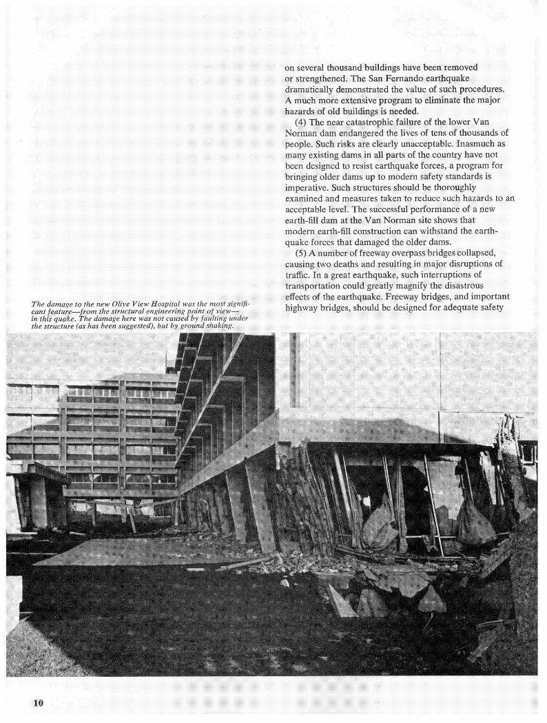
in Sylmar where a concrete frame, tile-wall, pre- earthquake code hospital building collapsed, killing 44 people. Another 11 were killed elsewhere, including 2 crushed by a collapsed freeway overpass, and an additional 9 were reported to have died from heart attacks. Four major facilities in the central region of the shock suffered severe damage: the new Olive View Hospital (initial cost $27 million); the Svlmar Converter Station
the Pacific Intertie (this large electrical switching and
There was also severe damage from ground movernei o the $6.5 million San Fernando juvenile facility, and ribrational and ground-movement damage to numerous . . . . . . . . .. ..

xtures and ceilings, and plaster cracking occurred hroughout the San Fernando Valley and also in the idjoining areas of Glendale, Pasadena, Los Angeles, an o the north at Newhall and Saugus.
An estimated $30 million damage was done to bridges md overpass structures on the Golden State, Foothill.
.. .. . - . . .
way. Bridges on the Antelope Valley and Foothill reeways in the epicentral area also received serious lamage.
Permanent ground displacements caused extens
t ¥ntra area from approximately $4.5 million d Telephone's central facility in S communications were hampe police headquarters and by des facility at the Veterans Hospital.
The faulting and the ground m with the shaking, damaged thousa hundreds were damaged to the po longer could be occupied. Ch common vibrational damage Pasadena.
Old, weak buildings in downtown S as far away as Pasadena, Los An suffered significant damage, usually in the form of falling masonry. Two people were killed by failure of o buildings in downtown Los Angeles. Caltech' building, Throop Hall, suffered extensive era nonstructural tile filler walls and to the exterior facing. No structural damage to it occurred in this earthquake, but Throop Hall falls well below modem standards, and its eventual fate has not yet been decided.
Although the earthquake damage was severe, there were several factors which limited the disaster the earth- quake might have caused. First, the area subjected to the most damaging shaking was of small size, and it w immediately adjacent to a relatively undamaged area containing extensive fire, police, medical, and o service facilities. These services were adequate to cope with the situation without becoming seriously overloaded.
A second fortunate factor was that most people were
of residential construction common here is high1 resistant to earthquake destruction. The typical strong wood frame house may be seriously cracked and damaged, but it seldom collapses completely with a major threat to life and limb. Only a very few, perhaps two or three, people were killed in their homes during this earth- quake. If the shock had occurred just three hours later, the collapsed Psychiatric Day Care Center at the Olive View Hospital would have been occupied, the freew overpasses would have collapsed on lanes of traffic, and the falling debris from old buildings in San Fer and Los Angeles would have pelted busy sidewalks. The resulting casualty toll would have been much more severe.
Another favorable factor was the lack of major land- slides in densely populated areas. Such slides were a major source of damage in the Alaskan earthquake of 1964 and in the 1970 Peruvian earthquake, in which rock and ice avalanche buried two towns, with an estimated 20,000 deaths. Fortunately, the possibi such slides in the Los Angeles area seems small.
By far the most fortunate escape from disaster was the survival of the two Van Norman dams which were both
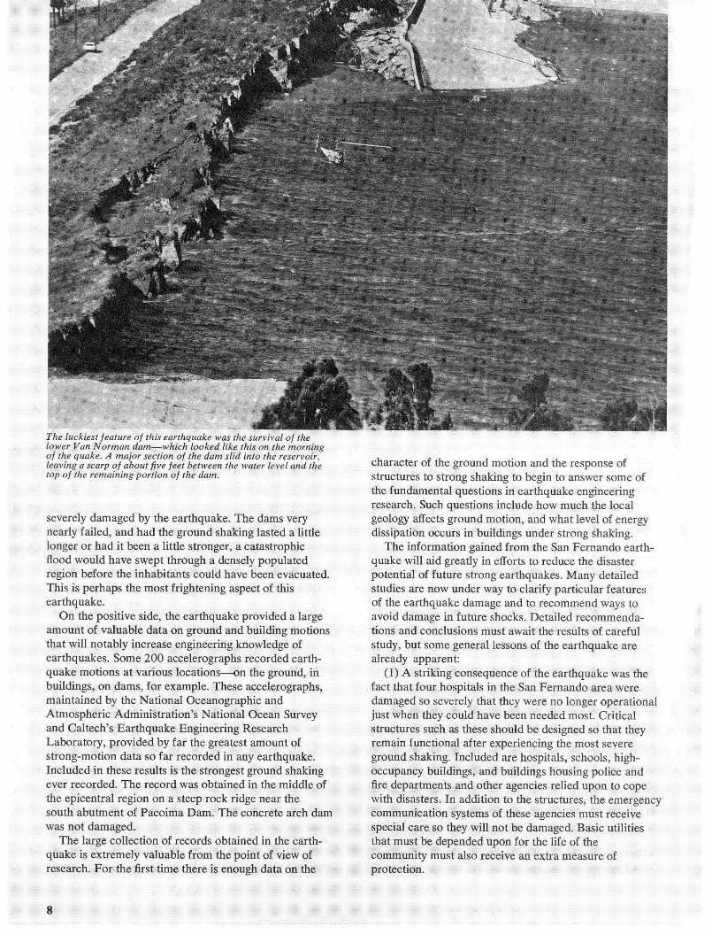
o f the quake. A major section of the dam slid into the reservoir, leaving a scarp of about five feet between the water level and the character of the ground motion and the response of top o f the remaining portion of the dam. structures to strong shaking to heein to answer some of - - -
e fundamental questions in earthquake engineering restarch. Such questions include hi)\\ much the local
severely damaged by the earthquake. The dams very geolocy aflccti ground motion. and what level of enern . early failed, and had the ground shaking lasted a dissipation occurs in buildings under strong shaking
ke will aid greatly in efforts to reduce the
s are now under way to clarify particular featu earthquake damage and to recommend way
oid damage in future shocks. Detailed recomme ns and conclusions must await the results of car
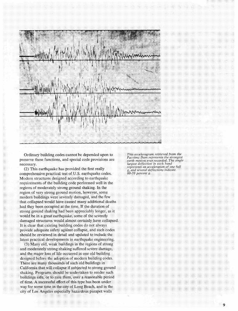
altech's Earthquake Engineering Research atory, provided by far the greatest amount
rong-motion data so far recorded in any earthqna uded in these results is the strongest ground s recorded. The record was obtained in them
is extremely valuable from the point of view of ch. For the first time there is enough data on the
)n of very strong ground motion, howeve ern buildings were severely damaged, an' collapsed would have caused many addil
itrong ground shaking had been apprec ~ o u l d he in a great earthquake, some o >. ~ ..-. J .............. ...... ,> -1 -.-. ...--
ft is clear that existing building codes do not always provide adequate safety against collapse, and such codes should be reviewed in detail and updated to include the . . . . . . . .
shaking. Programs should be undertaken to render such buildings safe, or to raze them, over a reasonable period of time. A successful effort of this type has been under
of Los Angeles especially hazardous parapet walls
or strengthened. The San Fernando ea dramatically demonstrated the value o A much more extensive program to eli . < ... .... .
causing two deaths and resulting in major disrup traffic. In a great earthquake, such interruptions transportation could greatly magnify the disastro . . - . .. . . highway bridges, should be designed

tate of knowledge in earthquake engineering. (6) It is noteworthy that, in the region of strong sha
chool buildings designed and constructed under the ..... " . -.., . , . , ' T , . L . .
e lesson is clear that such hazardous school buildinj st be eliminated or strengthened. 7 ) None of the tall
Nearly all the bookshelves, collapsed on the upper ~ toney of Calteih v Mdltkan Library, and about 75,000 books spllird 10 rite
downtown Los Angeles of these structures Tall can be made to resist the strongest shaking withou collapse, hut this does not occur automatically. Un the special care devoted to the design of recent tall bui ings is continued in the
represent a significant increase in over-all investm facilities shows that the earthquake-resis Once essential function and safety of life and limb these facilities must be markedly improv estimated that it will be at least a year b becomes an economic problem; the initial cost m completed at the Sylmar Converter Sta balanced against the possible cost of repair toea suffered approximately $30 million da
(9) The approximate damage cost of $ the effects on vital services from a moder occurring on the fringe of the Los An area point out the large disaster pot the many engineering studies now under w earthquakes. If the shock had occurred near the c actions and regulations prompted by this e of the city, or if a great earthquake San Andreas fault, it would seem that the damage approach three or four services would be severely crippled from the San Fernan disaster was not too la of the metropolitan area to overco medical, and protective systems handled the inc burdt itive normalcy has bee aPPr( expectea. nowever. rnat s COB
ass1 (1U) t he San kernando earthquake agai
strated that the most practical approach to safety in earthquakes is e

The San Fernando Earthquake - What It Did to the Earth continued from page 5
ment that began at a depth of about eight miles beneath the epicenter (located about 7 Y2 miles east of Newhall). It then moved southward and upward along a fault plane that slanted at an average angle of 45 degrees, and actually broke the surface of the ground in the Sylmar- San Fernando area. This kind of a fracture, known as a thrust fault, is typical of the faults that had been mapped by geologists in this area prior to the earthquake. However, the particular fault that broke on February 9 had not been recognized as being especially active, and there was no obvious reason to consider it more dangerous than the many other similar-appearing faults throughout the Los Angeles region.
Investigations of the earthquake area indicate the presence of a combination of land movements. Some was of the strike-slip variety, in which the northern block moved to the west relative to the southern block. Combined with the strike-slip movement-and probably dominant over it-was the overthrust movement in which one block went up and over the opposite block.
In the San Fernando earthquake, the §a Gabriel Mountains (the northern block) moved in a thrust-like motion southwestward over the San Fernando Valley floor (the southern block) along a fault plane that slants shallowly back underneath the mountain range. Preliminary estimates indicate that the mountain block rose up at least three feet in relation to the valley floor and moved at least three feet to the south.
When the fault met the surface, it produced a great deal of ground shortening. As much as six feet of shorten- ing took place across the Sylmar fault trace-the fault trace is the line where the fault surface outcrops on the surface of the earth. Such ground displacement extended over a wide zone, buckling streets and sidewalks and causing heavy damage to many structures.
The first large shock to be so thoroughly monitored and recorded, this earthquake is expected to produce more significant and more detailed data than any other earth- quake in history, because it occurred very near the center of the southern California seismographic recording network. Caltech's Seismological Laboratory operates an array of 20 permanent recording stations extending from the Owens Valley to the Mexican border and comprising both conventional and special purpose instruments. Seismic records produced at eight of the stations, six of which are operated directly by Caltech and two by the State Department of Water Resources, were relayed by microwave to the Seismological Laboratory in Pasadena
where instantaneous readings were made. The records from the remaining 12 stations are made photographically and are mailed to the lab once a week for processing and evaluation. Since February 9, this network has detected and recorded over 200 aftershocks of magnitude 3.0 or greater.
Aftershocks of earthquakes are usually distributed over a wide area that is more or less centered on the area of the fault that originally breaks. The aftershock sequence following the San Fernando earthquake seems to be a normal one, and Caltech seismographic records taken before the quake show no indication of identifiable foreshocks. A careful examination of records from the Mt. Wilson seismic station indicates that no shocks exceeding magnitude 1.5 had occurred in the area in the preceding eight days. No shock exceeding magnitude 2.5 had been identified in the area during the preceding four months, and it appears that the most recent identifiable event within the area of subsequent activity was a shock of magnitude 2.6 that occurred north of Sylmar on September 28, 1970.
The greatest concentration of aftershock activity appears to lie roughly in the shape of an inverted U symmetrically disposed with respect to the epicenter of the main shock and to the pattern of the surface faulting. The epicenters of the aftershocks tend to delineate the boundaries of the thrust displacement that caused the quake, although many of the shocks along the western limb seem to represent deeper strike-slip events whose relationship to the main thrust fault is very complex and not yet understood.
Very accurate hypocentral locations have been determined for some 25 of the aftershocks. Hypocenters are the points beneath the earth's surface where the first motion occurs. The deepest of these hypocenters is about eight miles, and the average depth is close to three miles. As has been observed in other aftershock distributions associated with thrust faults, the bulk of the aftershocks following the San Fernando earthquake occurred predominantly in the upper plate of the earth, leaving it more broken up and shattered than the underlying rock.
Since the San Fernando earthquake, many questions have been asked about its possible effect on the "big" earthquake that has long been forecast for the southern portion of the San Andreas f ault. These are extremely difficult questions to answer. Southern California is an area with a very complex series of faults that have different directional trends and different styles of

movements, though they fall, essentially, into two major fault systems. One of these systems is composed of the east-west trending ranges like the San Gabriel Mountains and particularly the mountains near Santa Barbara. These mountains are characterized by east- west trending faults that tend to exhibit thrusting of the type observed in the San Fernando Valley earthquake.
The other system is directly related to the San Andreas fault that slices through western California for more than 600 miles, extending in a straight line southeasterly from the Mendocino County coast to the southern San Joaquin Valley; there it bends to the west and then continues southeast along the north flank of the San Gabriel Mountains. Branches of it eventually reach the Gulf of California.
The San Fernando quake occurred within the first system, and its effect on the San Andreas system is still unclear to geologists. But it is believed that the com- pression along the 50-mile stretch where the San Andreas bends westward may have had some direct relationship
A seismological map o f the epi- centers of the main shock and aftershocks o f magnitude 3.0 or greater that occurred in the month following the February 9 earthquake. The aftershocks occurred in a peculiar inverted U-shape. The hypothesis is that the segment of the fault that broke has this same U- shape. Aftershocks may represent the points where the displacement on the fault actually stopped.

with the February 9 earthquake, even though there was apparently no movement along the big fault.
"The bend," says Don Anderson, director of Caltech's Seismological Laboratory, "tends to block and jam the general northwesterly movement (at the rate of about two inches a year) of that part of California that lies west of the San Andreas fault in relation to the rest of the state east of the fault. The fault runs in virtually a straight line both north and south of the bend. In those areas this general northwesterly movement is punctuated by occasional horizontal slipping along the San Andreas and its associated faults, accompanied by earthquakes.
"But near the bend the horizontal slipping gets hung up. The compression builds up, and instead of horizontal movement there is overthrust faulting in that region, with land thrusting over land along fault breaks, triggering
Some historic earthquakes on the San Andreas and its associated faults
in California and northern Mexico. The zigzag lines show where the
ground surface was broken in various earthquakes. The bend in the Sun
Andreas, just north of Los Angeles, may have played an important role
in triggering the Sun Fernando quake.
earthquakes like the one in San Fernando." Will the Los Angeles area experience another major
I quake th i s time along the San Andreas? Clarence Allen, professor of geology and geophysics, says, "We know something about the rates at which movements are taking place along the San Andreas fault. We have geodetic observations from surveying in the Imperial Valley and in northern California that give us some clue to the rate at which the shape of California is changing, and if our computations are correct-and there are many assumptions in this-it leads us to believe that an earthquake along the San Andreas fault should occur at an interval of once every 100 to 200 years.
"We last had a break down here in 1857, and consequently our feeling is that a major quake on this, the southern portion of the San Andreas fault, say tomorrow, wouldn't be any surprise. The stresses relieved
1 0 50 100 150 2 0 0 Miles - -

at the time of the 1857 earthquake have again built up to the point where they deserve attention."
The recent San Fernando earthquake and the continu- ing discussion about possible quakes along the San Andreas fault have focused new interest on an old question: Can earthquakes be predicted? Among the world's experts there is not much agreement on the subject. Some say precise earthquake prediction is impossible; others say it is possible but will take a long time and a lot of money.
Charles Richter, the inventor of the Richter Scale and Caltech professor of seismology, emeritus, says flatly that it can't be done. Clarence Allen and Don Anderson both agree that predicting earthquakes is an impossible business at the present time, but it is an objective worth working toward. According to Allen, precise prediction is "not something we'll do in the immediate future, but even if we are never able to predict earthquakes in terms of exact time and place, we may be able to reach another objective of great value. That is, through geological and geophysical studies, we may be able to ascertain which areas are likely to have more earthquakes than other areas and what the average frequencies of any given magnitude in those areas will be. This is what the engineers need in order to design buildings safely and economically."
Anderson says that we can't predict earthquakes now except in the sense that we know there have been and will continue to be a lot of them. He feels it is not a problem you can successfully tackle with statistics because the records just don't go back far enough in time.
The primary technical obstacle to achieving a relative prediction capability is a lack of instrumentation. Currently, southern California has only about 30 seismic stations, and they are located about 12 miles apart. Ideally, a grid of many seismographic stations not less than six miles apart would be necessary to keep accurate tabs on the seismic activity in most areas. More importantly, special purpose instruments such as strain gages and tiltmeters are required to monitor the strains before an earthquake.
While the problem of earthquake prediction is still unresolved, it is clear-as everyone was reminded on February 9-that California will continue to have hundreds of earthquakes every year. And some of them will be big ones.
This article is a summary of the early findings from the San Fernando earthquake by the Division of Geological and Planetary Sciences.
Among the many fortunate people who survived the earthquake with a bare margin of safety was Dee Burr, graduate secretary in Caltech's chemistry division. She and her husband, who is the caretaker of the Pacoima Dam, awoke February 9 to find that their bedroom wall had come very close to being crushed by a boulder fallen from the mountain behind their house.