report on the field course
TRANSCRIPT

UNESCO-IHE 2015 Field Course 24 May – 5 June 2015 Isaiah Krutak & Katherine Smith The UNESCO-IHE field course provided valuable educational avenues for learning. During the two week course, 28 of us students rode a bus 5,000 km through six European countries and a wide variety of terrains and climates. Each site we visited was carefully chosen based on its engineering achievement or notable natural feature. Each stop also exhibited a different language, culture and foods to experience. As we took these things in, we also got to know and learn from each other. Since UNESCO-IHE focuses on capacity building among professionals in developing countries, the majority of the students came from Indonesia, Ethiopia, Benin, Tanzania, Zambia, Zimbabwe, Nigeria, Eritrea, Pakistan and Bangladesh. However, developed countries, such as Australia and the United States, were also represented, which prompted many conversations and exchanges of cultural viewpoints.
The course started in the wet climate of Deflt, Netherlands, before driving through Belgium and into northern France. From there, we made our way to southern France and the Mediterranean coast. There we encountered the Mediterranean climate and the associated fauna as we drove along the coast to Italy. From southern Italy, we went up into the mountainous regions of northern Italy and the Alps of Austria. Our last stop was in the relatively flat region of Germany before returning to the Netherlands. What follows in this document is a description of the sites we visited together. Information was gathered from class and tour handouts, as well as tour notes.
The UNESCO-IHE Institute for Water Education building where the students attend classes in Delft, Netherlands.
A group photo at the hydroelectric power station in Austria.
From left to right: Annelieke, Suryadi, and Dick. Annelieke and Suryadi are professors from UNESCO IHE who planned and expertly guided us on our trip. A professor missing from the picture is Abraham, who joined us for the second week of the trip after Annelieke departed. Dick was the outstanding bus driver who was full of great information along our trip.
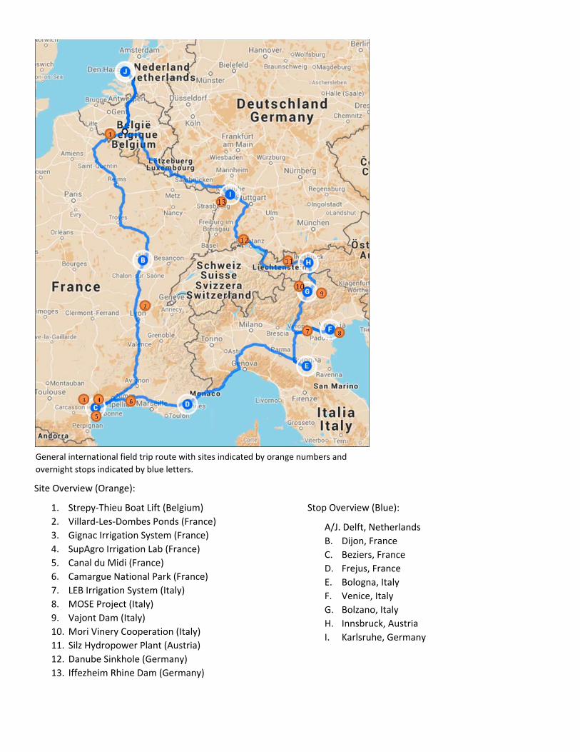
Site Overview (Orange):
1. Strepy-Thieu Boat Lift (Belgium) 2. Villard-Les-Dombes Ponds (France) 3. Gignac Irrigation System (France) 4. SupAgro Irrigation Lab (France) 5. Canal du Midi (France) 6. Camargue National Park (France) 7. LEB Irrigation System (Italy) 8. MOSE Project (Italy) 9. Vajont Dam (Italy) 10. Mori Vinery Cooperation (Italy) 11. Silz Hydropower Plant (Austria) 12. Danube Sinkhole (Germany) 13. Iffezheim Rhine Dam (Germany)
Stop Overview (Blue):
A/J. Delft, Netherlands B. Dijon, France C. Beziers, France D. Frejus, France E. Bologna, Italy F. Venice, Italy G. Bolzano, Italy H. Innsbruck, Austria I. Karlsruhe, Germany
General international field trip route with sites indicated by orange numbers and overnight stops indicated by blue letters.

Strepy-Thieu Boat Lift (Belgium)
Located on a branch of the Canal du Centre in the municipality of le Roeulx, Hainaut, Belgium, the Strepy-Thieu boat lift is currently the tallest boat lift in the world. With a height difference of 73.15 meters, the boat lift was designed and built as a part of the Canal du Centre’s modernization program. The program sought to increase vessel accommodation from 300 to 1350 metric tons. Construction of the boat lift began in 1982 and was completed in 2002. Canal traffic increased from 256 kT in 2001 to 2,295 kT in 2006.
The boat lift operates similar to an elevator lift by moving two independently counterweighted caissons. The caissons remain the same weight due to Archimedes’ Principle, where the water displaced equals the weight of the boat. Each caisson has working dimensions of 112 by 12 meters and water depths between 3.35 and 4.15 meters. Eight winches are powered by four electric motors to move the lifts, which takes an average of seven minutes to travel the 73.15 meter height difference.
The structure is massively reinforced, weighing 200,000 metric tons, which is four times the weight of the Empire State Building. Such structural rigidity is needed to guard against torsional forces during operation. The estimated cost of the structure is 160 million Euros.
Canals are important because they are safer and more efficient for transporting goods. Since these canals are used for navigation, they are kept level and have no current. The 1,500 km of navigable canals in Belgium are kept full by pumping in water from local surface water sources.
Downstream of the boat lift. The Strepy-Thieu Boat Lift.
One of the two caissons, what the boat is in when lifted. Winches and electric motors that are used for one of the two caissons.

Villard-Les-Dombes: Land of 1,000 ponds (France)
There are roughly 1100 ponds in the Dombes region of France, which provides the unique environment for fish and crop production, otherwise known as aquaculture. The region also serves as an important wildlife sanctuary for non-migratory and migratory birds. The first ponds were created in the 12th century by local lords and monks to raise fish. Poverty and malnutrition was a problem at the time, so fish, which was a staple food in the predominantly catholic region, provided a means for nourishment.
Every year the ponds are emptied and either refilled or put under crop production. A typical area spends three years under water, followed by two years under crop production. The ponds are drained to keep the areas hygienic and revitalized. As they are drained, fish are sorted by size to either be harvested or returned to another pond for further growth. The predominant commercial fish is carp, but ponds also contain pike, perch, and other noncommercial fish. Corn and oats are the major crops, but wheat and other cereals are also produced. Traditionally, fertilizers have been used to increase yields, but there has been a recent movement to reduce or eliminate chemical fertilizers due to environmental concerns.
Typically, around 20 ponds are linked in a row in order of descending elevation. Sluice gates are then used to control water flow from pond to pond or field to field. Ownership among pond networks vary. Some networks are singularly owned, while other networks contain many owners. Management therefore requires effective social interactions between owners, which is facilitated by a locally elected governing body.
Throughout the region there is also an abundance of wildlife. The region is also home to an impressive collection of over 300 different species of birds from all over the world at the Parc des Oiseaux.
Sluice gate between ponds with birds in the background.
Pond under crop production with water draining.
Sluice gate diverting water from field.
In the foreground is a field under crop production and in the background is a pond.
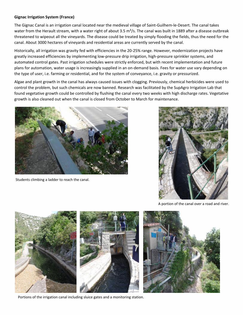
Gignac Irrigation System (France)
The Gignac Canal is an irrigation canal located near the medieval village of Saint-Guilhem-le-Desert. The canal takes water from the Herault stream, with a water right of about 3.5 m³/s. The canal was built in 1889 after a disease outbreak threatened to wipeout all the vineyards. The disease could be treated by simply flooding the fields, thus the need for the canal. About 3000 hectares of vineyards and residential areas are currently served by the canal.
Historically, all irrigation was gravity fed with efficiencies in the 20-25% range. However, modernization projects have greatly increased efficiencies by implementing low-pressure drip irrigation, high-pressure sprinkler systems, and automated control gates. Past irrigation schedules were strictly enforced, but with recent implementation and future plans for automation, water usage is increasingly supplied in an on-demand basis. Fees for water use vary depending on the type of user, i.e. farming or residential, and for the system of conveyance, i.e. gravity or pressurized.
Algae and plant growth in the canal has always caused issues with clogging. Previously, chemical herbicides were used to control the problem, but such chemicals are now banned. Research was facilitated by the SupAgro Irrigation Lab that found vegetative growth could be controlled by flushing the canal every two weeks with high discharge rates. Vegetative growth is also cleaned out when the canal is closed from October to March for maintenance.
Students climbing a ladder to reach the canal.
A portion of the canal over a road and river.
Portions of the irrigation canal including sluice gates and a monitoring station.

Research site along the Gignac Canal to test flush velocities for clearing algae in the canal.
Gate being placed to divert water from the canal into the four “canals” of the research structure.
Four canals of varying widths and velocities – inlet. Four canals of varying widths and velocities – outlet.

Breathtaking views from the Gignac Canal.
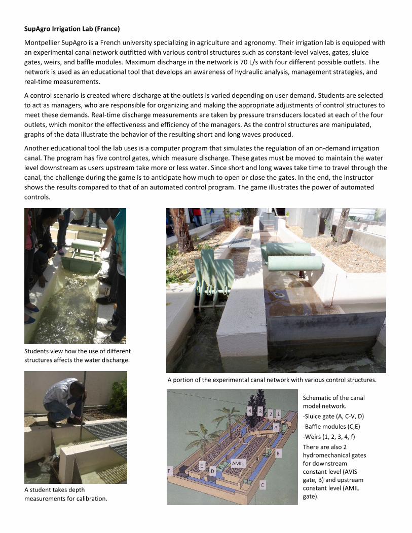
SupAgro Irrigation Lab (France)
Montpellier SupAgro is a French university specializing in agriculture and agronomy. Their irrigation lab is equipped with an experimental canal network outfitted with various control structures such as constant-level valves, gates, sluice gates, weirs, and baffle modules. Maximum discharge in the network is 70 L/s with four different possible outlets. The network is used as an educational tool that develops an awareness of hydraulic analysis, management strategies, and real-time measurements.
A control scenario is created where discharge at the outlets is varied depending on user demand. Students are selected to act as managers, who are responsible for organizing and making the appropriate adjustments of control structures to meet these demands. Real-time discharge measurements are taken by pressure transducers located at each of the four outlets, which monitor the effectiveness and efficiency of the managers. As the control structures are manipulated, graphs of the data illustrate the behavior of the resulting short and long waves produced.
Another educational tool the lab uses is a computer program that simulates the regulation of an on-demand irrigation canal. The program has five control gates, which measure discharge. These gates must be moved to maintain the water level downstream as users upstream take more or less water. Since short and long waves take time to travel through the canal, the challenge during the game is to anticipate how much to open or close the gates. In the end, the instructor shows the results compared to that of an automated control program. The game illustrates the power of automated controls.
Students view how the use of different structures affects the water discharge.
A student takes depth measurements for calibration.
A portion of the experimental canal network with various control structures.
Schematic of the canal model network. -Sluice gate (A, C-V, D) -Baffle modules (C,E) -Weirs (1, 2, 3, 4, f) There are also 2 hydromechanical gates for downstream constant level (AVIS gate, B) and upstream constant level (AMIL gate).

Canal du Midi (France)
The Canal du Midi is a 241 km canal located in Southern France. It connects with the Garonne River to create a single hydraulic route through France between the Atlantic Ocean and the Mediterranean Sea. Its construction, which spanned the years 1666 to 1681, ended the need for French merchants to sail around Spain and through the Spanish controlled Strait of Gibraltar. Construction was supervised under Pierre-Paul Riquet during the reign of King Louis XIV.
Along its length, the canal has 63 locks to accommodate an elevation drop of 189 meters. Other structures include 126 bridges, 55 aqueducts, 7 canal bridges, 6 dams, one spillway, and one tunnel. On average, water depth is between 1.8-2 meters, the surface width is between 16-20 meters, and the bottom width is roughly 10 meters. This takes an average supply of 90 million m3 of water to maintain every year.
Water supply was the biggest challenged faced by Riquet. In fact, before Riquet was granted the royal seal for his project he had to prove he could actually convey a sufficient amount water to the canal. He did this with his own funds, building a canal from the Black Mountains to the highest point on the Canal du Midi.
Maintenance was and is still a problem with the canal. Silt builds up and needs to be removed annually. Additionally, branches, leaves, weeds, and trees need to be removed. Every winter the canal closes for two months to deal with these maintenance issues. Weather and other natural processes also have their impacts, requiring managers to always be on the lookout for leaks and cracks.
Rail and automobile traffic has largely reduced the commercial traffic along the canal. Therefore, the current primary use of the canal is for tourists, recreation, and housing. During the dry season, the canal also feeds nearly 700 irrigation valves, serving roughly 40,000 hectares of land.
Dredging upstream of the lock system. Group photo at the Canal du Midi.
Left: Boats sit at the top of the lock gate as water begins to released to lower the water level and boats.
Right: After the water level and boats were lowered, gates were opened and the boats started moving into the next lock.
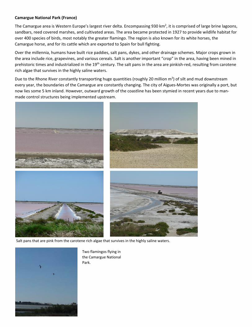
Camargue National Park (France)
The Camargue area is Western Europe’s largest river delta. Encompassing 930 km2, it is comprised of large brine lagoons, sandbars, reed covered marshes, and cultivated areas. The area became protected in 1927 to provide wildlife habitat for over 400 species of birds, most notably the greater flamingo. The region is also known for its white horses, the Camargue horse, and for its cattle which are exported to Spain for bull fighting.
Over the millennia, humans have built rice paddies, salt pans, dykes, and other drainage schemes. Major crops grown in the area include rice, grapevines, and various cereals. Salt is another important “crop” in the area, having been mined in prehistoric times and industrialized in the 19th century. The salt pans in the area are pinkish-red, resulting from carotene rich algae that survives in the highly saline waters.
Due to the Rhone River constantly transporting huge quantities (roughly 20 million m3) of silt and mud downstream every year, the boundaries of the Camargue are constantly changing. The city of Aigues-Mortes was originally a port, but now lies some 5 km inland. However, outward growth of the coastline has been stymied in recent years due to man-made control structures being implemented upstream.
Salt pans that are pink from the carotene rich algae that survives in the highly saline waters.
Two flamingos flying in the Camargue National Park.

We spent a day of driving through Italy near the Mediterranean Sea. We had views of the sunny and bright Mediterranean on one side and gloomy mountains on the other. Part of our drive this day included going to the front of the bus to sing a song from back home.
Donald Djissa from Benin and Isaiah Krutak.

LEB Consortium (Italy)
The consortium was constituted in 1958 to address the needs for irrigation, soil conservation, environmental preservation, and water quality. The canal, which is 16 km long and irrigates some 82,675 hectares, was built between 1973 and 1983. On average the consortium manages an intake of 10 m³/s from the Adige River. The first section of the canal is a trapezoidal open channel, whereas the second portion is pressurized and fed through underground conduit. Flow measurements are all electronic, and remote controlled automation systems have recently been installed. However, each system still maintains manual controls and cut-offs.
The canal is also an outlet for a local tannery. The wastewater is first treated at the tannery before being dumped into the canal. Water samples are taken both up and downstream to monitor water quality. If certain levels are reached the tannery is required to shut down until acceptable levels are observed.
A sediment trap is located right before the second portion of the canal. Instead of paying for disposal, the consortium saves money by using the sediment to stabilize banks. Furthermore, even though the water in the second portion is pressurized, it is eventually delivered to users via gravity. Therefore, users need to extract water for their own irrigation needs.
Part of the canal near a hydroelectric power plant. A local tannery in the background that outputs into the canal – notice the different in water color!
A sedimentation trap that is before the underground canal. The outlet structure of the underground canal that flows through smaller open canals for user irrigation.

MOSE Barrier (Italy)
The MOdulo Sperimentale Elettromeccanico, or MOSE Barrier, is a project aimed at protecting the city of Venice, Italy from more extreme and frequent flooding. Construction of the barrier began in 2003 and is projected to be completed in 2017. The barrier intends to block tides of up to 3 meters from entering the Venetian lagoon through its three inlets. An artificial island was built at the Lido inlet in order to adequately reinforce the barrier.
MOSE is comprised of 78 mobile gates lined up in rows to create 4 separate barriers. The gates are metal box-like structures 20 meters wide, 18.5 to 29 meters tall and 3.6 to 5 meters thick. Under normal tidal conditions the gates are filled with water and remain lying down on the sea floor. However, when extreme tidal conditions are predicted, the gates are filled with air causing them to rotate about their hinge and stand up. Thus, they block the entering tide. Once the tidal threat is reduced the gates are once again filled with water and lowered back to the lying condition.
Each gate has two hinges and weighs 42 tons. It will take 30 minutes to raise the gates and 15 minutes to lower them. Typical tidal events last about 4 to 5 hours. There will be one large lock and three small locks in operation during tidal events to allow transit of vessels.
Venice.
Construction of the MOSE barrier that is projected to be completed in 2017.
Katherine Smith.
Mori Vinery Cooperation (Italy)
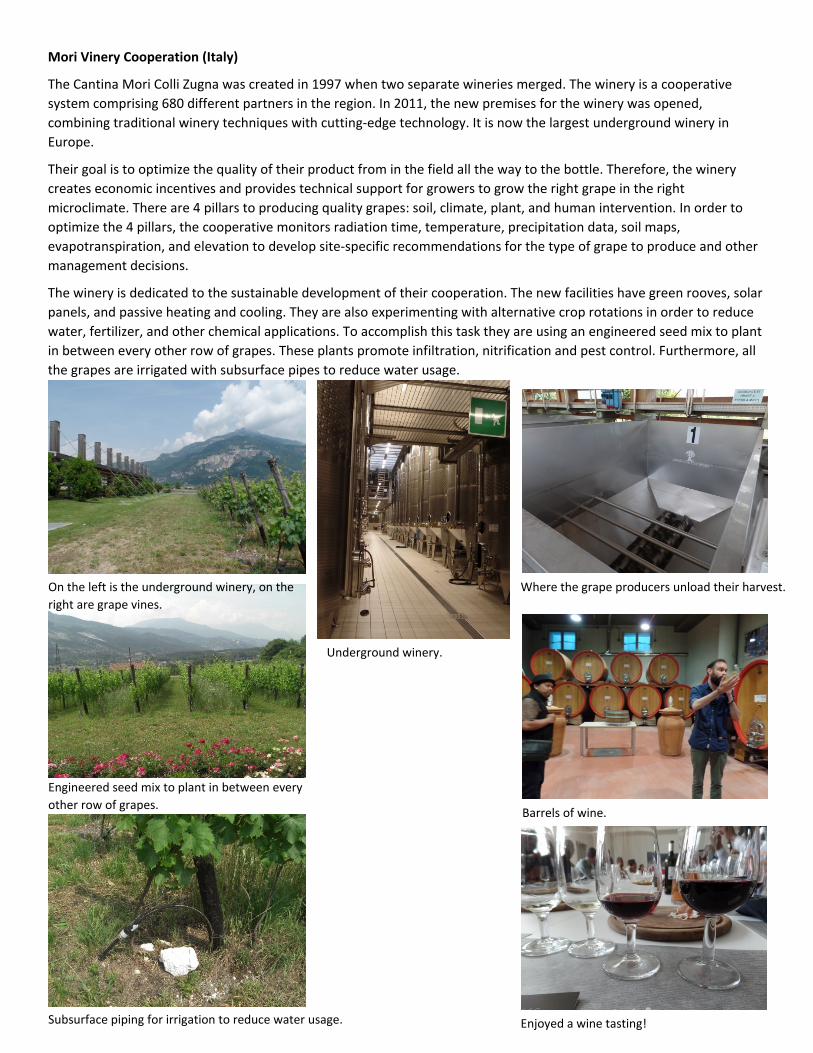
The Cantina Mori Colli Zugna was created in 1997 when two separate wineries merged. The winery is a cooperative system comprising 680 different partners in the region. In 2011, the new premises for the winery was opened, combining traditional winery techniques with cutting-edge technology. It is now the largest underground winery in Europe.
Their goal is to optimize the quality of their product from in the field all the way to the bottle. Therefore, the winery creates economic incentives and provides technical support for growers to grow the right grape in the right microclimate. There are 4 pillars to producing quality grapes: soil, climate, plant, and human intervention. In order to optimize the 4 pillars, the cooperative monitors radiation time, temperature, precipitation data, soil maps, evapotranspiration, and elevation to develop site-specific recommendations for the type of grape to produce and other management decisions.
The winery is dedicated to the sustainable development of their cooperation. The new facilities have green rooves, solar panels, and passive heating and cooling. They are also experimenting with alternative crop rotations in order to reduce water, fertilizer, and other chemical applications. To accomplish this task they are using an engineered seed mix to plant in between every other row of grapes. These plants promote infiltration, nitrification and pest control. Furthermore, all the grapes are irrigated with subsurface pipes to reduce water usage.
Enjoyed a wine tasting!
On the left is the underground winery, on the right are grape vines.
Subsurface piping for irrigation to reduce water usage.
Engineered seed mix to plant in between every other row of grapes.
Barrels of wine.
Where the grape producers unload their harvest.
Underground winery.

An evening out and about with a group of students exploring Italy.
A group picture at the end of our hike with the Italian mountains in the background.
After the tram we took a short train ride.
Found a path leading to some beautiful views.
We took a tram up the Italian mountain side.
Vajont dam (Italy)
Vajont Dam, located in northern Italy in the Vajont River valley under Monte Toc, is one of the world’s tallest dams. The 262 meter high dam is no longer in use following a massive landslide on October 9th, 1963 that filled the reservoir with over 25 million cubic meters of rock, earth, and debris. The landslide lasted only 45 seconds and created a huge tsunami that overtopped the dam, flooded the reservoir upstream, wiped out several small villages, and killed around 2,000 people.
The dam is considered a double arch dam, which means the dam is thicker at the base and tapers to a thinner top. The difference in thickness, which in this case goes from 22.11 meters thick at the base to 3.4 meters thick at the top, is needed to overcome the increasing hydrostatic force at greater depths of water. Additionally, the dam is 27 meters wide at the base and reaches 191 meters in width at the top.
Design and construction of the dam was overseen by the Societa Adriatica di Elettricita, SADE, and completed between 1956 and 1960. The reservoir was to feed the Soverzene power plant, which at the time was the biggest hydropower plant in the world. The Vajont Dam itself also had a small turbine and generator that could be operated when water levels were sufficiently high. The reservoir was fed by the Vajont River and many other smaller dams in the area. Discharge into the reservoir was estimated at 2.3 m3/s, which would have taken two years to fill the reservoir. However, the dam was never able to be completely filled, but test fills were done in 1960, 1962, and 1963.
Before construction began, engineers for SADE concluded from geological surveys performed in the 1920’s that the area was stable enough for a dam. However, late in the design phase, the Italian government lobbied to have the height of the dam increased from 200 m to 262 meters, making it the tallest double arch dam in the world. The increased height meant an almost three-fold increase in the reservoir’s volumetric capacity, prompting unheeded doubts about the geologic stability of the area.
At the outset of the first test fill, small landslides were observed along with cracks in the ground, leaning trees, and loud noises emanating from the area. This sparked further geologic surveys, which revealed the true instability of the Monte Toc slope. Engineers responded by building an alternate by-pass tunnel in the event of inevitable future landslides. Despite local protests and predictions of a larger landslide, filling of the reservoir proceeded in 1962 and 1963. Again, seismic activity was detected, but SADE engineers maintained they could control the situation. However, a large landslide occurred on October 9th, 1963, creating a huge tsunami that wiped out several small villages and killed around 2,000 people.
Ethical debates followed the disaster. It was initially deemed an act of god, but later trials held the SADE engineers accountable. Complicating the situation was the nationalization of all electrical companies in Italy in November 1962, which moved ownership and responsibility of the dam from SADE to the Ente Nazionale Energia Electtrica, ENEL.
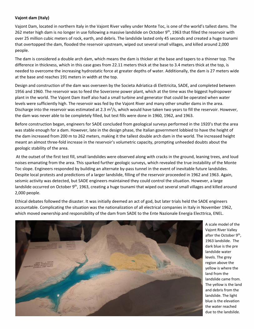
A scale model of the Vajont River Valley after the October 9th, 1963 landslide. The dark blue is the pre landslide water levels. The grey region above the yellow is where the land from the landslide came from. The yellow is the land and debris from the landslide. The light blue is the elevation the water reached due to the landslide.

Model of landscape before the 1963 landslide.
Model of landscape after the 1963 landslide.
The non-reservoir side of the dam.
The reservoir side of the dam. Note the land in front of the dam from the landslide that has filled in the reservoir.
Silz Power Plant (Austria)
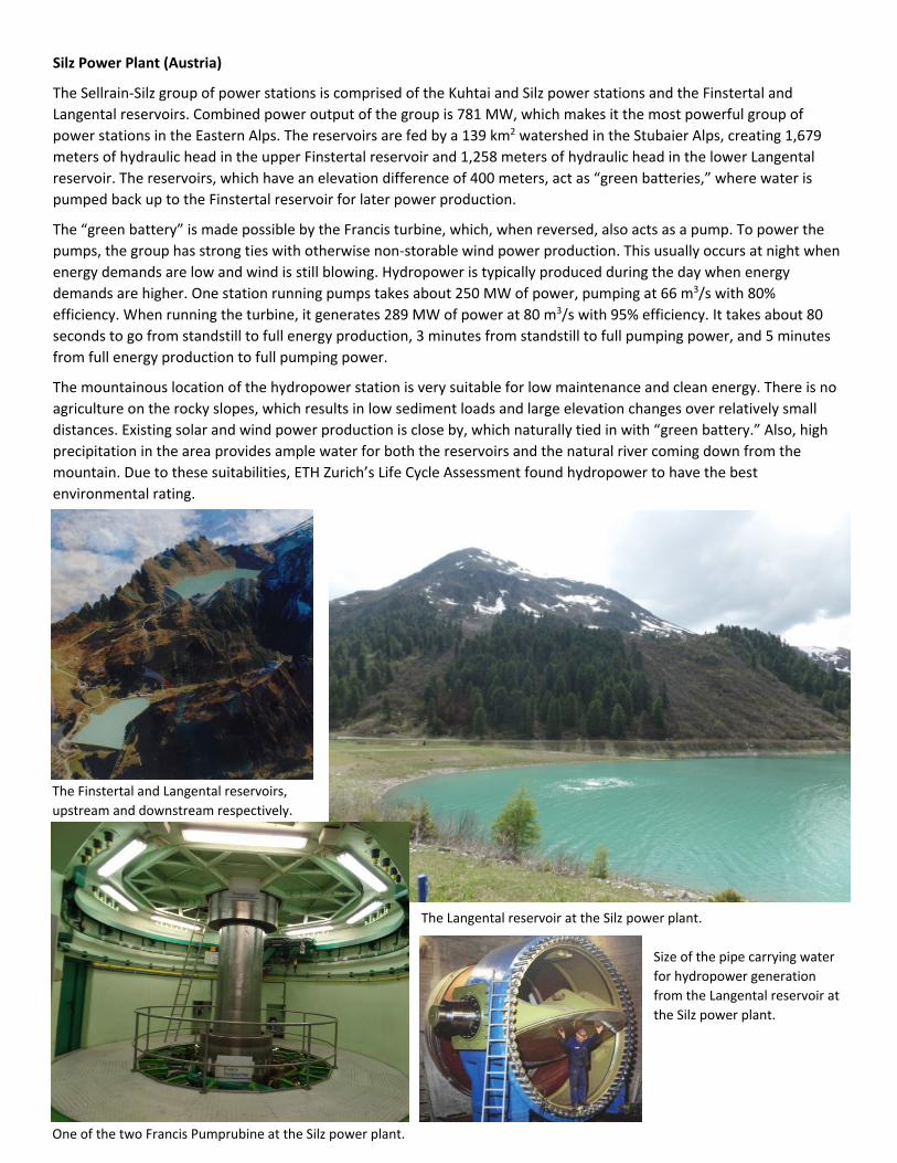
The Sellrain-Silz group of power stations is comprised of the Kuhtai and Silz power stations and the Finstertal and Langental reservoirs. Combined power output of the group is 781 MW, which makes it the most powerful group of power stations in the Eastern Alps. The reservoirs are fed by a 139 km2 watershed in the Stubaier Alps, creating 1,679 meters of hydraulic head in the upper Finstertal reservoir and 1,258 meters of hydraulic head in the lower Langental reservoir. The reservoirs, which have an elevation difference of 400 meters, act as “green batteries,” where water is pumped back up to the Finstertal reservoir for later power production.
The “green battery” is made possible by the Francis turbine, which, when reversed, also acts as a pump. To power the pumps, the group has strong ties with otherwise non-storable wind power production. This usually occurs at night when energy demands are low and wind is still blowing. Hydropower is typically produced during the day when energy demands are higher. One station running pumps takes about 250 MW of power, pumping at 66 m3/s with 80% efficiency. When running the turbine, it generates 289 MW of power at 80 m3/s with 95% efficiency. It takes about 80 seconds to go from standstill to full energy production, 3 minutes from standstill to full pumping power, and 5 minutes from full energy production to full pumping power.
The mountainous location of the hydropower station is very suitable for low maintenance and clean energy. There is no agriculture on the rocky slopes, which results in low sediment loads and large elevation changes over relatively small distances. Existing solar and wind power production is close by, which naturally tied in with “green battery.” Also, high precipitation in the area provides ample water for both the reservoirs and the natural river coming down from the mountain. Due to these suitabilities, ETH Zurich’s Life Cycle Assessment found hydropower to have the best environmental rating.
The Finstertal and Langental reservoirs, upstream and downstream respectively.
The Langental reservoir at the Silz power plant.
One of the two Francis Pumprubine at the Silz power plant.
Size of the pipe carrying water for hydropower generation from the Langental reservoir at the Silz power plant.

Danube Sinkhole (Germany)
The Danube Sinkhole describes an underground river connecting the Danube River in the Upper Danube Nature Park with the Radolfzeller Aach River about 12 km away. Water flows through well-stratified limestone which has been hollowed out into underground caverns. Roughly 155 days out of the year the Danube River completely vanishes underground into these caverns. This number changes from year to year, depending on annual climatic conditions, but the highest recorded was set in 1921 with 309 days without water.
The relationship between the Danube River and the Radolfzeller Aach River was established in 1877 when a local geologist dumped 10 kg of sodium fluorescein, 20 tons of salt, and 1200 kg of shale oil into the Danube River. A couple days later, all three substances were then found in the Radolfzeller Aach River.
Students checking out the Danube riverbed.
A sign explain details of the vanishing river.
The reappearance of the Danube River water 12 kilometers away into the Radolfzeller Aach River.

Iffezheim Dam Rhine (Germany)
The Iffezheim Dam is the most northerly dam on the Rhine River and was built between 1970 and 1975. Germany’s largest run-of-the-river hydropower plant accompanies the dam and was completed in 1978. The dam has two locks that operate 24 hours per day, 365 days per year. Since erosion has been a problem downstream of the dam, 173,000 m3 of sand and gravel are deposited every year. In 2000, Europe’s largest fish pass was completed near the dam to restore a migratory route for fish. The pass is 300 meters long and overcomes an average of 11 meters in elevation change.
On the left is the lock with low water elevation, and on the right is the lock with high water elevation.
In the background is a blue and yellow ship being lowered in one of the two locks. In the foreground is a barge being raised in the other lock.
The gate closing on one of the locks to prepare for raising a barge up.