report on the mobile mapping symposium - tu wieninfo.tuwien.ac.at/ingeo/sc4/report/mmscairo.pdf ·...
TRANSCRIPT

Report on the Mobile Mapping Symposium
Organized by
FIG Commission 5
The IAG Special Commission 4 ISPRS Commission II
Cooperating Organizations:
University of Calgary (Canada) The Survey Group, Ain Shams University (Egypt)
The Egyptian Survey Authority (Egypt) The National Lab for Information Engineering in Surveying, Mapping and Remote Sensing
(China)
Supported By
Applanix Corporation (Canada) Ashtech - Magellan (USA/UK)
Premier GPS (Canada)

Nearly six years ago, the Ohio State University hosted the first International Symposium on Mobile Mapping systems. At that time, it was very clear that Mobile Mapping had the potential for providing a diversity of services and products to the mapping community. The Second International Symposium, which took place in Bangkok, Thailand in 1999, provided further evidence – the quality and diversity of papers and the number of attendees proved that Mobile Mapping was an area of research of its own that deserves a separate symposium. Since then, substantial progress has been made in the area of Mobile Mapping technologies, progress that would not have been anticipated six years ago. The 3rd International Symposium on Mobile Mapping Technology was successfully held in Cairo, Egypt, January 3-5, 2001. It was co-organized by Ain Shams University, Egypt, the ISPRS Commission II (WG II.1 “Real time Mobile Mapping”), the FIG Commission V (WG 5.3 “Kinematic and Integrated Positioning Systems”), the IAG Special Commission IV (WG SC4.1 “Mobile Multi-Sensor Systems “), the University of Calgary, the Egyptian Survey Authority and the Chinese National Lab for Information Engineering in Surveying, Mapping and Remote Sensing. The symposium was financially supported by Ashtech-Magellan Corp. (USA/UK), Applanix Corp. (Canada), and Premier GPS Inc. (Canada). The symposium provided a stimulating casual environment to promote scientific presentations, interactive discussions, and information exchange. It brought together 350 participants from 29 countries, who are specialists, engineers, users and those interested in mobile mapping technology, kinematic real-time positioning, sensor integration and calibration, feature extraction and 3-D data acquisition. 90 oral presentations in 18 sessions reported most recent R&D and application achievements of mobile mapping. The proceedings of the symposium, edited by Dr. Naser El-Sheimy, have been produced in a CD and can be ordered from the Department of Geomatics Engineering, The university of Calgary (E-mail Marguerite Anderson: [email protected] ) or from the Survey Group at Ain Shams University (E-mail: Dr. Atef Fayad: [email protected] ). The opening ceremony was chaired by Dr. Naser El-Sheimy, Convenor, and included welcome speeches by Prof. Jean-Marie Becker, Prof. Heribert Kahmen, and Prof. Chen Jun representatives of the sponsoring organizations, followed by welcome speeches by Prof. Mohamed Sheriah, the Dean of Faculty of Engineering of Ain Shams University, Prof. Hassan Ghallab, President of Ain Shams University, and Prof. Ibrahim El-Domery, the Egyptian Minster of Transportation (See Picture 1). Prof. Gerard Lachapelle gave a very informative keynote address on “Location: A 21st Century Utility” where he described how location and navigation technology, user requirements and new applications drive each other, with the users as the major beneficiaries. Gerard predicted that personal location and navigation applications will capture a large share of the location and navigation markets in the decade ahead. “The exciting technical program was complemented by a most interesting and educational social program that included a night cruise on the river Nile, a Sound and Light show at the Pyramids and individual visits to the countless historical sites of Cairo. Cairo is the oldest lived-in city in the world and is an historical treasure trove. The Egyptians are keenly aware of their own and other cultures and were most gracious hosts" said Gerard Lachapelle. The symposium also witnessed the signing of a Memorandum of Agreement (MoA) between Ain Shams University and the University of Calgary. The MoA was signed by Prof. Gerard Lachapelle as representative of the UofC and by both the Prof. Mohamed Sheriah, the Dean of Faculty of Engineering of Ain Shams University, Prof. Hassan Ghallab, President of Ain Shams University (See Picture 2). The MoA will strengthen further the relationship between the two universities and encourage academic exchange between them.

Picture 1: From Left: Prof. Hassan Ghallab, President of Ain Shams University, and Prof. Ibrahim El-Domery, the Egyptian Minster of Transportation, Prof. Mohamed Sheriah, the Dean of Faculty of
Engineering of Ain Shams University, Dr. Naser El-Sheimy, Convenor of the Symposium.
Signing the MoA between ASU and UofC
Picture 2: From Left: Prof. Adel Hadag, Prof. K. Morad, Prof. Hassan Ghallab, Prof. Gerard Lachapelle, Prof. Houda, and Prof. Mohamed Sheriah
The symposium was structured in such a way that features common to all Mobile Mapping Systems (MMS) were treated first before specific application; new applications, and trends in MMS were considered. Common features included the mathematical framework of direct georeferencing for land and airborne imaging sensors, kinematic positioning, object extraction and recognition, and estimation techniques common to all MMS. Only after these common features had been treated, specific sessions were dedicated to cover the full spectrum of Mobile Mapping Technology. The following highlights the major features of papers presented at the symposium; they can be categorized as follows:
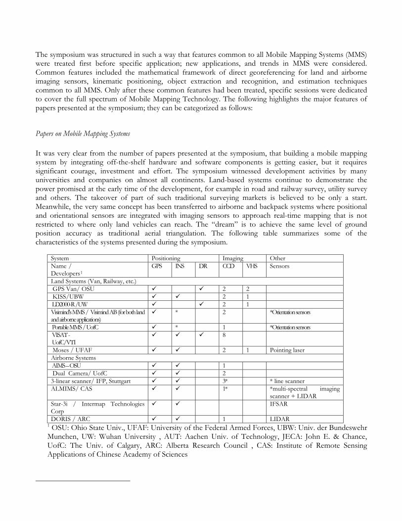
Papers on Mobile Mapping Systems It was very clear from the number of papers presented at the symposium, that building a mobile mapping system by integrating off-the-shelf hardware and software components is getting easier, but it requires significant courage, investment and effort. The symposium witnessed development activities by many universities and companies on almost all continents. Land-based systems continue to demonstrate the power promised at the early time of the development, for example in road and railway survey, utility survey and others. The takeover of part of such traditional surveying markets is believed to be only a start. Meanwhile, the very same concept has been transferred to airborne and backpack systems where positional and orientational sensors are integrated with imaging sensors to approach real-time mapping that is not restricted to where only land vehicles can reach. The “dream” is to achieve the same level of ground position accuracy as traditional aerial triangulation. The following table summarizes some of the characteristics of the systems presented during the symposium.
System Positioning Imaging Other Name / Developers 1
GPS INS DR CCD VHS Sensors
Land Systems (Van, Railway, etc.) GPS Van/ OSU 2 2 KISS/UBW 2 1 LD2000-R /UW 2 1 Visimind's MMS / Visimind AB (for both land and airborne applications)
* 2 *Orientation sensors
Portable MMS / UofC * 1 *Orientation sensors VISAT - UofC/VTI
8
Moses / UFAF 2 1 Pointing laser Airborne Systems AIMS – OSU 1 Dual Camera/ UofC 2 3-linear scanner/ IFP, Stuttgart 3* * line scanner ALMIMS/ CAS 1* *multi-spectral imaging
scanner + LIDAR Star-3i / Intermap Technologies Corp
IFSAR
DORIS / ARC 1 LIDAR 1 OSU: Ohio State Univ., UFAF: University of the Federal Armed Forces, UBW: Univ. der Bundeswehr Munchen, UW: Wuhan University , AUT: Aachen Univ. of Technology, JECA: John E. & Chance, UofC: The Univ. of Calgary, ARC: Alberta Research Council , CAS: Institute of Remote Sensing Applications of Chinese Academy of Sciences
Papers on New Developments and Applications of Mobile Mapping Systems Some of the new developments and applications presented during the symposium are: New Development
1. Helicopter Based Portable Handheld MMS for Avalanche Mapping: The system is developed by the Photogrammetric lab of the Institute of Geomatics at Swiss Federal Institute of Technology. It integrates light aerial camera and GPS/INS components to a platform that is free of the helicopter in 6 degrees of freedom. Experimental studies performed in the avalanche test site of "Vallée de la Sionne" allow determining the correct ratio between the system accuracy versus its flexibility. Experiments performed during the last two years in "Vallée de la Sionne" avalanche test site showed that helicopter-based photogrammetry is able to provide snow volume measurements with an accuracy of 20-30cm when good conditions for accurate exterior orientation and contrast are fulfilled.
2. A Portable MMS for the Survey Community: The system is developed by the Department of Geomatics Engineering at the University of Calgary. The goal of the system development is to overcome the drawbacks of current mobile mapping systems - namely their high cost, large size, and complexity - which have restricted their widespread adoption in the survey industry. The development of such a system satisfies the demand for a mobile mapping system that can compete both cost-wise and in user friendliness with current backpack GPS systems and conventional terrestrial survey systems, while realising the significant gains in efficiency typical for MMS. The system integrates a digital magnetic compass, dual-frequency GPS receiver and consumer digital camera into a multi-sensor mapping system. First system testing indicates that with three images at a 20m object-to-camera distance, absolute accuracies of fewer than 25 cm are achieved. This is comparable to current single-frequency GPS data acquisition systems. The internal agreement of points surveyed using the system is under 10 cm.
3. Airborne Laser-ranging and Multi-spectral Imaging Mapping System (ALMIMS): The system is a multi-sensor mapping system developed by the Institute of Remote Sensing Applications of Chinese Academy of Sciences. It is integrated with multi-spectral imaging scanner, laser ranging scanner, Global Positioning System (GPS), and Inertia Navigating System (INS), all of which are tightly coupled and synchronized, insuring the pixel-level correspondence of image and laser ranging points. The result is a high-resolution multi-spectral image overlapped with laser ranging grids at certain intervals. It can produce ortho-rectified images, digital surface models, contour maps, and perspective maps at near real-time without ground control points. It can be used for automatic buildings/tree extraction, and semi-automatic road tracing.
4. DORIS (Differential Ortho-Rectification Imagery System): DORIS is an airborne multi-sensor mapping system which has been under development for years at Alberta Research Council. DORIS combines a laser-scanning technology with digital imaging technology to produce high-resolution and highly accurate ortho-rectified planimetric image maps. The focus of DORIS is on acquiring data for fundamental biophysical entities of sustainable forest eco-systems and reducing the cost of the planning and conduct of forest operations.
New Applications: 1. Automatic Bald Digital Terrain Model Reconstruction from Digital Surface Data Acquired from an
Airborne SAR System: Two approaches for automatic reconstruction of bald DTMs from Digital Surface Models (DSMs) are presented in this paper; namely hierarchical and non-hierarchical approaches. The non-hierarchical approach is mainly used for urban areas while the hierarchical approach is suitable to different terrain types and data with different spatial resolutions. Test results show that for the hierarchical approach the accuracy of the reconstructed bald DTM, when referenced
against bald terrain surface models generated from a Lidar mapping system, is typically less than 1.25 meters RMSE in urban and low mountain areas. This is obviously an acceptable result as the accuracy of the original SAR DSM is at 1-2 meter (RMSE) level.
2. Automatic Generation of a Hierarchical DEM for Mars Rover Navigation: This paper presents techniques for the generation of a hierarchical DEM using descent and rover imagery for Mars mapping and rover localization. During a descending process of a Mars spacecraft, ten descent images may be taken at approximately every half of the altitude. The images can be used to generate an initial DEM of the landing site. The paper proposed a further refinement technique for the DEM both in accuracy and resolution to form a five-layer hierarchical DEM, with the resolution ranging from one centimeter in the immediate area of the landing center to one meter in the boundary region about 1 km away from the center. The DEM is generated by using the hierarchical descent images with an increasing sequence of resolutions. The produced hierarchical DEM can be used for an interactive system to assist rover traverse design and for landmark extraction for automatic Mars rover localization. The authors mentioned that in future research, the rover images will also be used to expand the hierarchical DEM as the rover traverses farther from the landing center. The DEM will be refined and expanded as more new rover images become available.
3. Integrating Data From Terrestrial Mobile Mapping Systems and Aerial Imagery for Change Detection Purposes: Data fusion from different sources is one of the key problems facing the photogrammetric and computer vision research communities. In this paper, a new approach for combining data from terrestrial Mobile Mapping Systems (MMS) and aerial imagery. Road network data, captured by a MMS, is used to determine the Exterior Orientation Parameters (EOP) of an aerial image - Single Photo Resection (SPR).
4. Integrating photogrammetric data from mobile ship-borne and airborne systems for support conservation process, and environmental analysis of cost heritage along the “CinqueTerre” coast in the Gulf of Liguria region, Italy: The project is directed to emphasize the environmental heritage, on which Levanto and Bonassola base their own tourist economy, focusing the guide lines and the analysis required for the landscape insertion of the recovering project of the old railway tunnel facet to the seacoast, work over land and work over sea, through 3D virtual navigation on the gulf of Levanto and on urban centre.
5. Automatic Building extraction from airborne laser systems: This paper introduces a series of building extraction techniques in compatible with Airborne Laser-ranging and Multiple-spectral Imaging Mapping System (ALMIMS), including shadow-based method for large buildings in urban area with sparse laser ranging points, and direct laser-point segmentation method for buildings in rural areas. These techniques perform well in semi-real-time, thus provide a fast data source for GIS system.
6. Integration of Mobile Phone Location Services into Intelligent GPS Vehicle Navigation Systems: GPS for position determination in vehicle navigation systems in stand alone mode works quite well only for open areas. It is obvious that in the case of obstruction of satellite-receiver visibility either position accuracy is bad or position determination is not possible. In cities with high-rise buildings, satellite visibility is a very critical issue for intelligent vehicle navigation systems. Therefore GPS positioning has to be combined with other methods, e.g. dead reckoning (DR) and map matching. Apart from this, other new technologies are available nowadays which can also be employed in navigation systems. In particular, mobile phones of the next generation, the so-called 3G (Third Generation) phones, will provide the ability to determine the location of any mobile phone subscriber anywhere, anytime, with a precision required for navigation systems. Thereby different strategies for position determination can be employed. It is claimed that the position fix can be obtained with an accuracy in the order of ± 125 m using current technologies in the widespread second generation GSM network. For the use of 3G mobile phones in the UTMS network, however, an increase in accuracy for the position determination by a factor up to 10 is expected. In this paper, preliminary results on the integration of mobile phone location services for temporary position determination into the system design is investigated.
Papers on Emerging Processing Techniques for Mobile Mapping Systems The continual development of Mobile Multi-Sensor Systems (MMS) is stimulating the development of intelligent processing techniques and new areas of application. Advanced techniques such as neural networks and snake models are currently under development to automate the measuring procedures and automatic object recognition from mobile mapping data. The two unique advantages of MMS-generated data: • Images have unknown exterior orientation parameters, and • The image sequences are along a known path These two advantages make the automation of object recognition and measuring procedures more efficient and robust. The science of multiple image based matching has found its application in mobile mapping processing. Bayesian networks have been actively researched and promise great potential for feature extraction. Real-time automation, in our opinion, remains to be the future of processing techniques for MMS. Some of the emerging processing techniques presented during the symposium are:
1. Motion estimation by Vision for Mobile Mapping with a Motorcycle: In this paper a vision algorithm to estimate the angular velocity of a motorcycle was introduced. This estimate, integrated with the measurements provided by other sensors such as a speedometer allows for a complete reconstruction of the trajectory followed by a motorcycle. The proposed scheme is, then, a valid alternative to the use of costly inertial platform to compensate for missing GPS data in order to geo-register information gathered by on-board sensors.
2. Motion Tracking Framework for Mobile Appliances: Mobile appliances, which include hand-held and portable devices, suffer from a limitation of portable power sources (battery) and a limitation of communication bandwidth for wide area applications. This paper presents a new framework for object motion tracking. The proposed technique reduces the computational of motion tracking algorithms as well as the number of bits that represents the object.
3. Online GIS Module for an Unmanned Aerial Vehicle: This paper provides an overview on how GIS could contribute to the navigation tasks of an unmanned autonomous aerial vehicle (UAV) and to the predictive capabilities required for identifying and tracking vehicles on the ground. The paper presented preliminary studies related to a project at Linköping University, Sweden. The project is an ambitious, long-term basic research project with the goal of developing technologies and functions necessary for the successful deployment of a fully autonomous UAV, operating over diverse geographical terrain containing road and traffic networks.
4. Innovative Active-Vision-Based Approach for Traffic Surveillance and Control: ITS is an emerging global industry that capitalizes on advanced technologies to better manage the dynamic, over-congested transportation networks of today. The current ITS boom has given rise to the need for a comprehensive real-time surveillance of traffic conditions over the transportation network to allow for dynamic control and management of traffic. Existing traffic detection technologies cover a wide spectrum of technologies as well as performance, ranging from modest pavement-buried inductive loop detectors to more advanced pole-mounted off-road detectors such as microwave, radar, and camera-based detectors. All existing detector types, however, share a common limitation of being point-detectors reflecting only traffic conditions at the locations of the detectors. This paper discusses research-in-progress to develop a mobile, bus-mounted machine vision technology for transit and traffic monitoring in urban corridors, as required by Intelligent Transportation Systems (ITS).

The technological development is still very rapid and major contributions in the area of MMS can be expected in years to come. The symposium shows a wide variety of applications including mapping, GIS, tracking, and navigation. Once different user groups better understand the potential of these techniques, a further diversification of applications areas can be expected. However, continued research and commercial development of mobile mapping systems, depends on the success in implementing potential applications, creating new markets and stimulating demand for this technology. The next International Conference on Mobile Mapping Technology will be held Kuming, China, May 25-27, 2003. For further information please contact Prof. Dr. Deren Li, Wuhan University, China, E-mail: [email protected] or Dr. C. Vincent Tao, University of Calgary, Canada, E-mail: [email protected] By Dr. Naser El-Sheimy Convenor of The Symposium Department of Geomatics Engineering, UofC Chair, the FIG C.53 WG "Kinematic and Integrated Positioning Systems " Chair, the IAG WG SC4.1 "Mobile Multi-Sensor Systems" Tel: 220 7587 E-mail : [email protected]