report to/rapport au : planning committee comité de l...
TRANSCRIPT
1
Report to/Rapport au :
Planning Committee Comité de l'urbanisme
and Council / et au Conseil
November 2, 2012 2 novembre 2012
Submitted by/Soumis par : Nancy Schepers, Deputy City Manager/Directrice municipale adjointe, Planning and Infrastructure/Urbanisme et Infrastructure
Contact Person / Personne ressource: John Smit, Manager/Gestionnaire,
Development Review-Urban Services / Examen des projets d'aménagement-Services urbains Planning and Growth Management/Urbanisme et Gestion de la croissance
(613) 580-2424, 13866 [email protected]
Kitchissippi (15) Ref N°: ACS2012-PAI-PGM-0223
SUBJECT:
OFFICIAL PLAN AND ZONING - 101 CHAMPAGNE AVENUE SOUTH
OBJET :
PLAN OFFICIEL ET ZONAGE - 101, AVENUE CHAMPAGNE SUD
REPORT RECOMMENDATIONS That the Planning Committee recommend Council: 1. Approve an amendment to the Preston-Champagne Secondary Plan to
redesignate the property at 101 Champagne Avenue South from Residential Low Profile to Residential High Profile, as detailed in Document 2; and
2. Approve an amendment to the Zoning By-law 2008-250 to change the
zoning of 101 Champagne Avenue South from a Residential Fourth Density exception zone (R4M [924]) to a Residential Fifth Density Exception Zone with a holding symbol (R5B[924]-h) as detailed in Documents 3 and as shown on Document 1.

2
RECOMMANDATIONS DU RAPPORT Que le Comité de l’urbanisme recommande au Conseil : 1. d’approuver une modification au plan secondaire afin de donner une nouvelle
désignation au 101, av. Champagne Sud, qui passe de utilisation résidentielle à profil bas à utilisation résidentielle à profil élevé, comme l’explique en détail le Document 2; et
2. d’approuver une modification au règlement de zonage 2008-250 afin de
modifier le zonage du 101, av. Champagne Sud, qui passera de Zone résidentielle de densité 4 dotée d’une exception (R4M [924]) à Zone résidentielle de densité 5 dotée d’une exception portant le symbole d’aménagement différé (R5B[924]-h), comme il est expliqué dans les documents 3 et tel que démontré dans le document 1.
EXECUTIVE SUMMARY
Assumptions and Analysis The subject property is located mid-block on the east side of Champagne Avenue South, between Beech Street and the dead-end portion of Hickory Street. The site is the former location of the Ottawa Humane Society (see location map, Document 1). The applicant is intending to amend the current secondary plan designation and zoning so they can construct two high-rise apartment towers, one being 22-storeys (71 metres) and the other being 25-storeys (81metres). The Department, while supporting that proposal, is also recommending flexibility to allow alternative forms of development. The site is located in a Mixed-Use Centre. The policies of the Official Plan identify Mixed-Use Centres as areas for substantial growth. The City’s compatibility and design policies provide a means for a new development to integrate into the existing community. The proposed amendment to the Secondary Plan is considered appropriate as it allows for the fulfilment of the pertinent policies related to high and low profile residential areas. The proposed zoning provides for redevelopment of the site with high-rise residential buildings to become a successful component of the surrounding neighbourhood by being located in the vicinity of other high rise buildings, having common neighbourhood characteristics, such as ground floor pedestrian access, building transition that respects lower density developments, a sun/shadow impact that minimizes impacts on the living area of surrounding buildings, as well as Ev Tremblay Park and has minimal traffic impact. Financial Implications If the amendment is carried and an appeal is brought before the Ontario Municipal Board, staff resources would be utilized to defend Council’s position. In the event the amendment is not carried and an appeal is launched, an external planner and possibly a transportation consultant would need to be retained at an estimated cost of $30,000 (planner only) to $60,000 (planner and transportation consultant).

3
Funds are not available from within existing resources and the expense would impact Planning and Growth Management’s 2013 operating budget. Public Consultation/Input Notification and public consultation was undertaken in accordance with the Public Notification and Public Consultation Policy approved by City Council for Official Plan and Zoning By-law amendments. Forty comments were received as a result of the notification process, 37 in opposition and one in favour. Two people also asked for additional information. A community public meeting was also held by the Ward Councillor on June 28, 2012 at the Civic Hospital. Approximately 20 people attended the meeting. A summary of the public comments received and a response to them are contained in Document 5. SOMMAIRE
Hypothèses et analyse La propriété en cause est située à mi-chemin entre deux pâtés de maisons du côté est de l’avenue Champagne Sud, entre la rue Beech et la partie en impasse de la rue Hickory. Cet endroit est l’ancienne adresse de la Société protectrice des animaux d'Ottawa (voir la carte jointe au document 1). Le requérant demande une modification à la désignation et au zonage actuels indiqués dans le Plan secondaire, afin de construire deux tours d’habitation, une de 22 étages (71 mètres) et l’autre de 25 étages (81 mètres). Tout en appuyant cette proposition, le Service recommande également une certaine flexibilité afin de permettre d’autres formes d’aménagement. L’aménagement projeté se situe dans un centre d’utilisations polyvalentes. Les politiques du Plan officiel définissent les centres d’utilisations polyvalentes comme des zones de croissance intensive. Les politiques de la Ville qui définissent la conception et la compatibilité fournissent à un nouvel aménagement le moyen de s’intégrer à la communauté existante. La modification proposée au Plan secondaire est considérée comme appropriée, car elle permet de respecter les politiques concernant les zones résidentielles à profil bas et à profil élevé. Le zonage proposé permettra le réaménagement du secteur grâce à des immeubles résidentiels de grande hauteur qui s’intégreront aisément au quartier environnant puisqu’ils seront situés près d’autres immeubles de grande hauteur et qu’ils comporteront des caractéristiques communes à celles du quartier environnant (accès piétonnier au rez-de-chaussée, une transition respectueuse des aménagements de plus faible densité, un impact « soleil-ombre » minimal sur les zones habitables des immeubles avoisinants et sur le parc Ev-Tremblay et une incidence minimale sur la circulation).

4
Répercussions financières Si la modification de zonage est adoptée et fait l’objet d’un appel devant la Commission des affaires municipales de l'Ontario, les ressources en personnel seront utilisées afin de défendre la position du Conseil. Au cas où la modification n’était pas adoptée et qu’un appel était interjeté, il faudra retenir les services d’un urbaniste et, possiblement, d’un conseiller en transport externes à un coût estimatif de 30 000 $ (urbaniste seulement) à 60 000 $ (urbaniste et conseiller en transport). Ces fonds ne sont pas disponibles dans les ressources actuelles et la dépense affecterait le budget de fonctionnement de 2013 du Service de l’urbanisme et de la gestion de la croissance. Consultation/commentaires publics Un avis public a été donné à cet égard et une consultation publique a eu lieu conformément à la politique concernant les avis et les consultations publics approuvée par le Conseil municipal pour les modifications au Plan officiel et aux règlements de zonage. La Ville a reçu 40 commentaires dans le cadre du processus de consultation, dont 37 étaient contre et un en faveur. Deux personnes ont demandé des renseignements complémentaires. Le conseiller du quartier a également tenu une séance d’information communautaire le 28 juin 2012 à l'Hôpital d'Ottawa, Campus Civic. Environ 20 personnes y ont assisté. Le Document 5 contient un résumé des commentaires du public et de la réponse qui leur a été fait. BACKGROUND
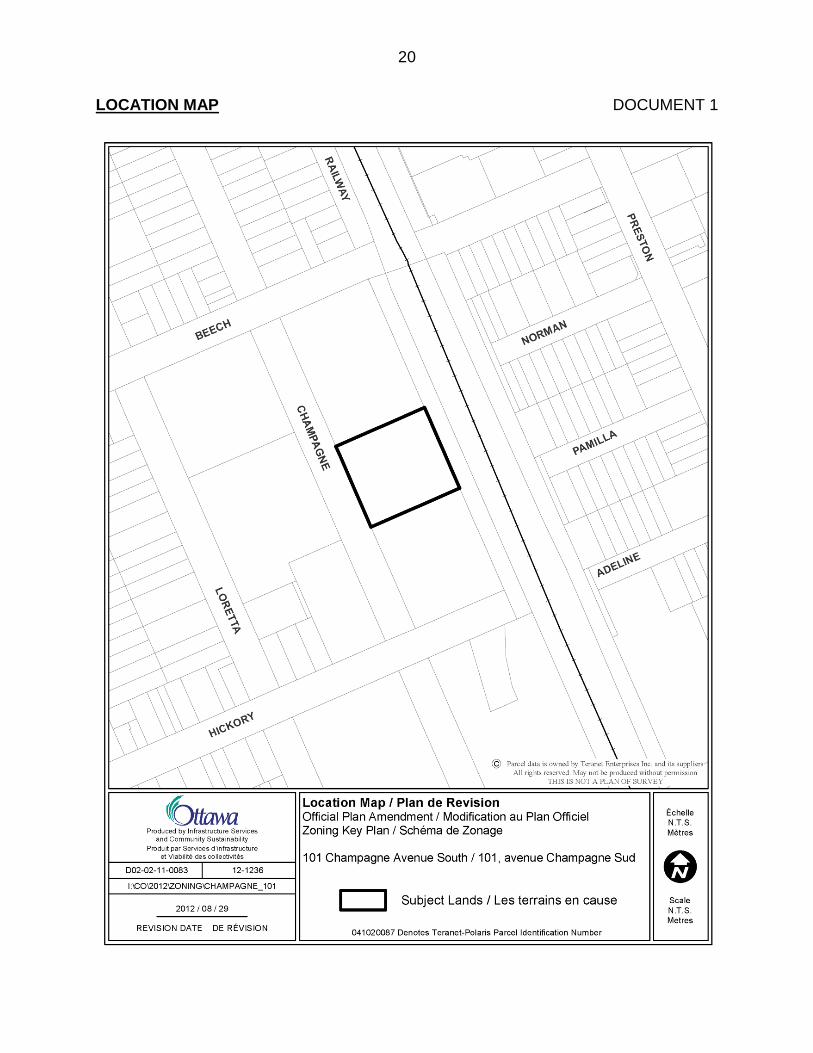
The subject property is located mid-block on the east side of Champagne Avenue South, between Beech Street and the dead-end portion of Hickory Street. The site is the former location of the Ottawa Humane Society. Adjacent to the north is Ev Tremblay Park; while to the east is the OTrain Corridor. To the west are an existing 14-storey high-rise apartment building and a new 12-storey high-rise apartment building under construction; while to the south is a vacant parcel of land that has recently been rezoned to allow a mixed-use development consisting of two towers, one being 16-storeys and the other 20-storeys. The subject property is currently zoned Residential Fourth Density (R4M[924]). The exception [924] adds an animal hospital as an additional permitted use. The Official Plan designates the subject property as ―Mixed-Use Centre‖ and the Preston-Champagne Secondary Plan designates the land as ―Residential–Low Profile‖. The Owner of the subject property has submitted applications to amend the current secondary plan designation and zoning so they can demolish the existing building and construct two high-rise apartment towers. The applicant submitted Official Plan and Zoning By-law amendment applications to accommodate two high-rise apartment buildings, one being 25-storeys (81 metres) high and the other being 22-storeys (71 metres) high. These buildings are proposed to have a maximum gross floor area of approximately 17 420 square metres and 15 330 square metres respectively. As part of the proposal, the Owner was also requesting modifications to performance standards related to yards, permitted projections, walkway

5
width and front yard landscaping. On the northwest corner of the site, along Champagne Avenue South and next to Ev Tremblay Park, the development concept proposed an open space area of approximately 25 metres by 25 metres to augment the adjacent Park with publicly accessible open space. In addition to the open space, the development concept also provided for an east/west pedestrian connection through the site to allow public access to the City pathway along the rail corridor. The development concept was evaluated by staff and the recommendations on that proposal were prepared in a submission for consideration by Committee and Council. However, prior to that proposal being considered, the Owner formerly requested to have their application amended to provide for two 30-storey towers. The applicant prepared servicing and traffic studies as well as a sun/shadow impact analysis on the surrounding properties to support that concept. Their concept later evolved into a proposal for one tower at 33-storeys (106 metres high) and another at 27-storeys (88 metres high) and was ready to be circulated for comment to technical agencies, Community Associations and people who responded to the original proposal. However, after participating in the recent Design Charrette for the Carling Bayview Community Design Plan and being informed by staff that from a planning perspective the additional height could not be supported, the request for additional height was formally withdrawn on October 16th. The applicant, as part of the withdrawal of their revised application, requested that their application as originally submitted for two apartment towers of 22 and 25-storeys be brought forward for consideration. At the time of their request for a greater height, the applicant also repositioned their buildings on the property and modified the building design, necessitating further changes to previous setback requests. The current concept for the proposed 22 and 25-storey development requested for approval reflects these changes as well as additional details related to rooftop amenity area and visitor parking. The refinements to the originally submitted development concept for the 22 and 25-storey buildings are addressed in the rationale section of this report. DISCUSSION
Recommendations 1 and 2 Carling – Bayview Community Design Plan The Preston-Champagne Secondary Plan is to be updated through the ongoing Carling-Bayview Community Design Plan (CDP). Given the number of development applications in the Carling Station area, a special focus has been given to this area through a design charrette held during the week of September 25th 2012. The results of this charrette are intended to give direction for the establishment of a clearer policy and design framework for the Carling Station area to evolve into a distinct urban place within the larger Bayview Carling Mixed Use Centre. Given the existing policy framework and the manner in which the development of this property will contribute to defining this node, staff is of the view that while the development concept submitted as part of the Official Plan and Zoning By-law amendment applications is seen as acceptable and can be a positive and unique element of the larger Preston/Carling Node, it has been

6
identified through the Design Charrette that other options for developing the site with high-rise residential uses may in fact also work well on the site and potentially make other positive contributions to establishing the node as a unique and dynamic place. The rezoning being recommended therefore is not tied specifically to the development concept provided by the applicant, but rather provides for allowing high-rise residential potentially comprising two buildings, one with a height of 25-storeys and the other with a height of 22-storeys and sets out various standards that could also accommodate an alternative development that could be determined through site plan and further design review processes that would be required. It is further noted that Policy 7 of Section 2.5.6 in the Official Plan, provides that development may take place in the absence of a Community Design Plan, provided the proposed development is consistent with the policies of the existing Official Plan designation. Development of the site with high rise residential, as presented in this report, is consistent with the policies for the Mixed-Use Centres. Planning Act and Provincial Policy Statement (PPS) Section 2 of the Planning Act outlines those land use matters that are of provincial interest, to which all City planning decisions shall have regard. The provincial interests that apply to this site include the appropriate location of growth and development and the promotion of development that is designed to be sustainable to support public transit and to be oriented to pedestrians. In addition, the Planning Act requires that all City planning decisions be consistent with the PPS, a document that provides further policies on matters of provincial interest related to land use development. The PPS contains policies which indicate that there should be an appropriate mix of uses to support strong, liveable and healthy communities. The recommended Official Plan and Zoning By-law amendments are considered consistent with the matters of provincial interest as outlined in the Planning Act and is in keeping with the Provincial Policy Statement by promoting efficient use of land and existing infrastructure for the development of an alternate form of housing as part of a node in proximity to existing and future rapid transit and to community services and amenities. This approach to redevelopment is supportive of the long term prosperity of the community and a form of city building in keeping with the direction of the PPS. Official Plan The Official Plan designates the subject property as Mixed-Use Centre and forms part of the larger Carling-Bayview Mixed-Use Centre. Lands having a Mixed-Use Centre designation are situated at strategic locations across the city and act as focal points of activity, not only for their local community but for the city at large. They are a critical element to the City’s growth strategy. Mixed-Use Centres are limited in number and represent opportunities for substantial growth. The density of development within Mixed-Use Centres is to take advantage of the opportunities offered by transit and ease of access on foot and by bicycle. Mixed-use Centres will contribute to the diversity of

7
land uses in the immediate area and foster the creation of vibrant centres of activity. The Official Plan establishes minimum density targets within Mixed-Use Centres, in order to help ensure that they develop at densities envisioned by the Official Plan. There are no maximum densities associated with Mixed-Use Centres. The proposed amendment to the Preston Champagne Secondary Plan and the proposed rezoning are in keeping with the intent of the Mixed-Use Centre policies as it provides for a high-rise, high-density residential development at a location where it is anticipated to occur. Such development, as demonstrated by the development concept submitted with the application, will enhance, in the Department’s view the character, vibrancy and functioning of the area as a unique dynamic place and contribute to the diversity of land uses in the area. The development concept demonstrates the potential for this site to provide for significant open space areas that would add a unique element to the public realm of the overall node through the addition of public accessible land to augment the existing adjacent park and increase pedestrian connections to the OTrain corridor. Key to this concept is ensuring public use of the open space. A more traditional development program with towers on a podium that has a strong street relationship is also seen as a viable proposition. The Mixed-Use Centre policies also indicate that when apartments are constructed, it is to be done at a medium or high density and the density of the development that is provided is to be at least that of the minimum density target established for the Mixed-Use Centre. In this instance, the Minimum Density Target for the Carling-Bayview Mixed-Use Centre is 200 people and jobs per hectare. As such, given that the site occupies a land area of approximately 3,310 square metres, it would be required to provide a minimum of 66 people and jobs per hectare. The development concept prepared by the applicant is intended to provide approximately 252 units with a density of approximately 1,233 people and jobs per hectare. The Official Plan indicates that high density development should be located within 400 metres of a rapid transit station or along an arterial roadway with all day transit. The subject property satisfies this direction as it is located approximately 325 metres walking distance from the Carling OTrain station, which in the future, will be a twin-track light-rail station. The current OTrain service is being upgraded to eight minute frequency starting in 2014. The proximity of the subject property to this station, as well as Ev Tremblay Park and the amenities of Preston Street to the east, helps support the use of transportation alternatives other than a private automobile. Furthermore, the construction of high-rise residential on the subject site, along with other recently approved residential and mixed-use developments in the immediate area, will help achieve the goal of a Mixed-Use Centre that provides a vibrancy of uses and amenities for the surrounding community and the city at large. In addition to the policies referenced above, the Official Plan also indicates that an application for development will be evaluated with reference to the Design Objectives and Principles in Section 2.5.1. and the compatibility policies contained in Section 4.11.

8
Section 2.5.1 The Official Plan acknowledges that introducing new development in existing areas that have developed over a long period of time requires a sensitive approach and a respect for a community’s established characteristics. Urban design is an important component of that sensitive approach and is concerned with how buildings, landscapes and adjacent public spaces look and function together. Good urban design and quality architecture can create lively community places with distinctive character and meaningful connections between the existing surroundings. The Official Plan provides guidance on measures that will mitigate the impact of new development by helping to achieve compatibility of form and function. Allowing for flexibility and variation that complements the character of existing communities is central to successful intensification. In general terms, compatible development means development that, although it is not necessarily the same as or even similar to existing buildings in the vicinity, nonetheless enhances an established community and coexists with existing development without causing undue adverse impact on surrounding properties. It fits well within its physical context and works well among those functions that surround it. Generally speaking, the more a new development can incorporate the common characteristics of its setting in its design, the more compatible it will be. Nevertheless, a development can be designed to fit and work well in a certain existing context without being ―the same as‖ the surrounding development. Renderings of the development concept submitted with the applications are provided in Document 5 of this submission. As noted, in the background discussion, this development concept is seen as acceptable and can be a positive and unique element of the larger Preston/Carling Node. Through the Design Charrette, it has also been determined that other options for developing the site with high-rise residential may also work well and potentially make other positive contributions to establishing the node as a unique and dynamic place. The analysis presented in this submission on how the policies in Section 2.5.1. and Section 4.11 are satisfied are focused on the development concept depicted in Document 5 with reference to how a modified development concept could also advance the design and compatibility policies and objectives of the Official Plan. Design Objectives and Principles Section 2.5.1. contains seven design objectives relating to how built environment should be addressed as the City matures and evolves. These Design Objectives are broadly stated and are to be applied within all land use designations from the broad citywide perspective down through to the neighbourhood, street, site and finally at the building perspective. The development concept submitted with the subject applications has been evaluated in relation to this section of the Official Plan, and the design objectives that are relevant to the concept and a modified development concept that would also provide for high-rise residential development. The first design objective is to enhance the sense of community by creating and maintaining places with their own distinct identity. The proposed amendment to the secondary plan and the rezoning will allow for a development that will meet this design objective by incorporating a quality of architecture that will enhance and improve upon

9
the image of the City as well as promote Ottawa as a major metropolis. The placement of two high-rise apartment buildings on the property, at opposite corners of the site is similar to and complements the character of the approved development adjacent to the south, which also has high-rise towers at opposite corners of the site. The concept submitted with the applications identifies a publicly accessible open space on the northwest corner of the subject property to augment the functioning of the adjacent park. While this open space area can serve as a unique feature for the area, having a more podium street related development could also be provided to continue the street edge fabric that will be provided by the development to the south. In terms of City image, the addition of high-rise development at this location serves to punctuate and mark at a distance, an area that the Official Plan identifies as evolving into a ―good urban place in its own right‖ and having ―significant growth potential‖. As well, with the increase in height requested, the design of the development as slender towers is such that the impact of the sun/shadows on the surrounding properties is minimized to the greatest extent practicable. A sun/shadow study undertaken for the applicant’s proposal indicates that while there is a shadow impact on the adjacent park to the north, the greatest impact occurs in the cooler months of the year with the impact being lower in the peak summer months. The slimmer floor plate proposed allows the shadows to move more quickly across the park, with the majority of the park always being in sunlight with no shadowing by the early afternoon. Further refinement of the development concept or a modified development concept would not significantly change the sun shadow impacts. This would be further addressed through the site plan approval process should a modified concept be pursued to ensure that the sun shadow impacts would not be greater. The second design objective relates to defining quality public and private spaces through development. As part of the development concept submitted with the applications, the applicant is proposing to provide public accessible open space on the property to enhance the functioning of the adjacent park by increasing the land area to be used by the public. This open space area also augments the existing character and continuity of the block between Beech and Hickory Street, which is over 50 per cent open public space. The podium of the proposed buildings will help define the area of the public accessible lands and the private areas of the condominium corporations. This is consistent with the direction of section 6.4(k) of the Preston-Champagne Secondary Plan dealing with enlargements to Ev Tremblay Park concurrently with redevelopment proposals. However, a modified development concept that extends the podium for the high rise development to be permitted to the street edge with street related residential as will be provided by the approved development to the south would also strengthen the residential fabric of Champagne Avenue and contribute to a quality residential street environment. A third design objective to consider when evaluating a rezoning proposal is the ability of the proposal to create places that are safe, accessible, easy to get to and easy to move through. The location of the site adjacent to public open spaces on three sides (Champagne Avenue, Ev Tremblay Park and the Greenway path along the OTrain) has the potential to provide this safe, and accessible pedestrian movement. This will be required through the detailed design development that will be undertaken through the

10
design review and Site Plan Approval processes. The final design will animate the adjacent park area and the greenway path along the OTrain corridor. The development concept submitted by the applicant further provides a public walkway between the two towers to connect the City sidewalk and open space in the southwest corner of the property, to the greenway path along the OTrain corridor. The fourth design objective provides that development should be integrated to complement and enliven the surroundings. It should allow the built form to evolve through architectural style and innovation and complement the massing patterns, rhythm, character, and context. The landscaping, open space, resulting light penetration and air circulation that would be provided by point towers, instead of a wider and shorter development, will complement and lighten the surroundings. To the south is another high-rise development with offset slimmer towers while to the north as mentioned, is the park. The development concept demonstrates an architectural and landscaped architectural style that shows innovation to complement the existing rhythm, character and context of the surrounding area. This would be further evolved and developed through the design review and Site Plan Approval Control process for development of the site with high rise residential towers. The fifth consideration of design is to provide for adaptability and diversity, by creating places that can adapt and evolve easily over time and that are characterized by variety and choice. The proposal to construct point towers is a relevant example of compact urban form for this site, given its area. Through the detailed design development that will be undertaken as part of the design review and Site Plan Control processes the landscaping, open space, building setbacks and architectural characteristics will provide for integrating the final high-rise development into the surrounding community. As well, the units provided will help fulfill the goal of providing accommodation to meet the needs of people of different incomes and lifestyles at various stages in life. The sixth design objective relates to understanding and respecting natural processes and features, and to promote environmental sustainability in development. Development of the site will increase the number of trees along Champagne Avenue and through the Site Plan Control process; stormwater will be retained and managed on site. The linear park to be provided along the east of the property as part of this proposal also presents tree-planting opportunities. The final consideration in design relates to maximizing energy efficiency and promoting sustainable design to reduce resource consumption, energy use and carbon footprint of the built environment. The orientation of buildings on the property with space between them will help increase the opportunity for solar gain and natural ventilation. Proximity to transit and sidewalks along Champagne Avenue, as well as a proposed pedestrian and cycling path along the OTrain corridor, will help maximize opportunities for sustainable transportation modes. Based on the foregoing, it is the Department’s position that development of the site with two high rise residential towers, one being 22-storeys and the other being 25-storeys, either reflecting the concept developed by the applicant, or a modified concept that may provide a more urban edge to Champagne Champagne satisfies the design criteria

11
contained in the Official Plan and that high-rise residential development will contribute to a positive urban design experience and be positively integrated into the surrounding neighbourhood. In addition to the design policies contained in the Official Plan, the proposed Official Plan and Zoning By-law amendment must also be evaluated in relation to the compatibility policies in Chapter Four of the Official Plan, namely Section 4.11. While certain policies, such as loading, lighting and the location of vehicular access are issues for Site Plan Control, there are other specific policies in this section that give direction to evaluating rezoning proposals relating to building profile and compatibility, traffic, sunlight and microclimate. Section 4.11 Section 4.11 indicates that high-rise buildings may be considered on lands that are designated as Mixed-Use Centre. In doing so, it will be considered both as an example of architecture on its own right and also as an element of urban design within a wider context. In this regard, the Official Plan provides direction in building profile and compatibility. As the site is to be developed with buildings over nine-storeys in height, they are considered as high-rise buildings in the Official Plan and the Official Plan states that high-rise buildings may be considered as appropriate forms of development in specific circumstances. These circumstances include on lands designated Mixed-Use Centre and on lands within 600 metres of a rapid transit station. The subject property meets both of these requirements. As part of the evaluation for building profile and compatibility, high-rise buildings are to be evaluated on how the scale, massing, and height of the proposed development relate to adjoining buildings, as well as the existing and planned context of the surrounding area. As stated, the site is to be developed with slimmer towers, which are similar in nature to the recently approved high-rise apartment buildings adjacent to the south. The heights recommended to be allowed also contribute to and are compatible with the varying profile of height of buildings in the node. These include the existing 14-storey building and 12-storey building presently being constructed on the opposite side of Champagne Avenue, the eight and 12-storey office buildings at the corner of Champagne and Carling Avenues and the approved 16 and 20-storey apartment towers at 125 Hickory Street. In relation to the lower density development to the north, the City Park and Beech Street provide a separation distance of approximately 107 metres, which mitigates negative privacy impacts and shadowing. The OTrain Corridor, being approximately 24 metres in width, offers an ample separation from the lower density area on the east side, to mitigate against shadowing and privacy issues. With the development occurring in this portion of the Mixed-Use Centre in the vicinity of Carling Avenue and Preston Street, the high-rise buildings will form an integral component and fit within a higher density node and aid in the creation of this node as a landmark within the wider area of the City. Another consideration for approval is how the proposed development enhances existing or creates views, vistas and landmarks, as well as how the top of the building affects the skyline. While tall, with a slender floor plate and a penthouse/top that complements the

12
architecture (as reflected in the concept plans developed), rather than pronouncing a difference, 25 and 22-storey towers for the site is seen as successfully fitting in with the taller existing buildings and those which have been recently approved, including the mixed-use building across the OTrain corridor at 500 Preston Street. It is the Department’s position that the quality of architecture as reflected in the concept plans developed will provide a positive contribution to the surrounding area and the location of both open space and a building along the street edge will enhance the public realm and contribute in a positive way to interaction at the street level. As stated, it is understood that when integrating taller buildings into a neighbourhood that has surrounding lower built areas, compatibility and integration are important considerations and one means to help ensure a positive integration is by the use of transition. Transition can consist of different elements. It can be the incremental change in building height, or using different massing at different heights, it can be obtained through exterior building treatment, architectural design (e.g. cornices) or building setbacks and it can be achieved through separation distances, such as open space areas. The development concept reflected in Document 5 uses various techniques to achieve transition. The architectural canopy feature at the top of the first floor provides a separation from the upper floors of the building and creates a human scale condition. The design details for these architectural features would be further developed through the design review and Site Plan Control processes. As well, by being adjacent to Ev Tremblay Park and the OTrain corridor, the site provides a measure of distance between the low density residential developments to the east and north to achieve transition and fit. In addition to the policies mentioned above, Section 4.11 also states that buildings, structures and landscaping will be used to clearly define public spaces such as streets and parks. Within intensification target areas, including where the subject property is located, development will be in the form of continuous building frontages that frame the street edge and support a more pedestrian friendly environment. Under the development concept submitted by the applicant, one of the proposed towers will be located adjacent to Champagne Avenue to occupy the street frontage and pick up on the building street edge character created by the recently approved development to the south and across Champagne Avenue. The other portion of the site street frontage will be open space and will augment the adjacent City Park and enhance that character of the street. This feature of the concept, while having merit, could also be modified to provide a more continuous building edge along Champagne Avenue to strengthen the residential fabric of the street. Under either situation, development under the proposed zoning will provide an appropriate street edge condition that is either urban or that will provide a transition from a more urban fabric to that of open space. The unique location of the property would allow either to be achieved successfully. Traffic Issues The applicant has undertaken a Traffic Impact Study for the proposed development. The anticipated increase in traffic from the proposed development is approximately 53 vehicles in both the AM and PM peak. As part of the traffic study, the applicant also

13
looked at the volumes of traffic anticipated to be generated from other development in the surrounding area, both existing and proposed (e.g. 125 Hickory Street, 320/330 Loretta Avenue, 100 Champagne Avenue and 855 Carling Avenue). When adding the expected traffic volumes from those developments, the volume of traffic from the subject property is only expected to represent six percent of the total increase. While the increase in traffic from the proposed development is small, about one vehicle per minute, to accommodate the anticipated increase in traffic from other expected developments in the area, modifications will be required to the surrounding roads. These include extending the east and west bound turn lanes on Carling Avenue at Champagne Avenue and extending the southbound turn lane on Champagne Avenue. These modifications will be addressed through the Site Plan Control process and will require the applicant to enter into an agreement with the Owners of 125 Hickory Street and 855 Carling Avenue to provide a representative share of all costs associated with the required road improvements. This in turn will provide the traffic expected to be generated, the opportunity to efficiently access the main roads, instead of using local neighbourhood streets. High Rise Infill Guidelines To help ensure that high-rise buildings are integrated into the surrounding urban fabric in a compatible manner, the City has prepared guidelines for this type of development. There are 68 guidelines separated into different categories, such as context, built form, pedestrians and the public realm, open space and amenities, environmental considerations, site circulation and parking, as well as services and utilities. While some of these are more appropriate for consideration through the Site Plan Control process, all of these are presented so as to allow high-rise buildings to be successfully integrated into the surrounding community. With regard to the proposed Official Plan and rezoning applications, high-rise buildings with compact floor plates will maximize views, light penetration, solar exposure, air circulation and ventilation. The smaller floor plates and resulting towers help minimize shadowing on surrounding properties. Architectural variety and the design of the building at the ground level will help maintain a human scale. If approved, the Official Plan amendment and rezoning will allow for a development that follows the Guidelines established by the City for high-rise developments. Preston – Champagne Secondary Plan In addition to the policies of the Primary Plan, the subject property is also subject to the policies of the Preston-Champagne Secondary Plan. This Secondary Plan seeks to reinforce the area as a diverse inner city neighbourhood with a broad mix of uses. It will allow major redevelopment that transitions to existing lower profile residential areas. The southwest quadrant, where the subject property is located, will incorporate both new office and residential development. The northwest edge of this area will be retained as a low profile residential area to provide transition to the existing low profile residential areas further to the north and west. The Secondary Plan designates the subject lands as Residential - Low Profile. Lands having this designation are intended

14
to be predominantly occupied by low profile residential uses in order to help preserve its residential character. The lands adjacent to the north are occupied by Ev Tremblay Park and as such are designated Open Space. Lands adjacent to the south and southwest are designated Residential - High Profile. Adjacent lands to the east are occupied by the OTrain Corridor and are designated Greenway Linkage. Lands to the west, directly across Champagne Avenue South that accommodate high rise apartments are not designated by the Secondary Plan. The property Owner is asking to re-designate the subject property to Residential – High Profile in the Secondary Plan. As mentioned, the intent of the Residential Low-Profile Designation is to ensure that there are developments within the Secondary Plan’s boundary which are low profile in nature. Indeed, there is an area with such a designation to the north, on the west side of the railway tracks, and also separate Low Profile areas to the east and north on the east side of the railway tracks. These residential low-profile areas are much larger in area and exhibit a more cohesive low profile fabric than the subject property. In fact, with the recent redesignation of 125 Hickory Street and 100 Champagne Avenue South, from Residential Low-Profile to Residential – High Profile, the Low Profile Designation in this specific area of the Secondary Plan now only applies to the subject property. The recent re-designations represent a rethinking of the desired development form in this area to advance policies of Volume I of the Official Plan for Mixed-Use Centres. The proposed amendment to High Profile will complement these recent re-designations, contribute to the evolving environment and consolidate this high profile node to the south of the park, with the park offering an area of transition to the Low Profile designated areas to the north. As well, since the redesignation of the subject lands removes only a limited area from the total land area designated Residential – Low Profile, it is the Department’s position that the overall policy directive of having areas occupied by low profile developments is not jeopardized and the change in development potential for this site is appropriate. Consideration should also be given to the fact that the former use of the property as an animal shelter was more institutional in nature and the proposed Official Plan amendment does not result in a loss of lands that are currently occupied by low profile residential uses. At the time of the completion of the Preston-Champagne Secondary Plan, in the early 1990s, the use of the existing rail line for rapid transit had not been contemplated and therefore, proximity to the OTrain station at Carling (which opened in 2001) was not used as a factor in determining the designation of the subject lands. In considering the site location is about 400 metres current walking distance from the OTrain Station, a more intense form of development that takes advantage of this proximity to rapid transit is considered appropriate and advances the relevant policies of the Official Plan, as expressed in Volume I.

15
Amendments to Performance Standards In addition to requesting a change to the current zoning applying to the property to allow a high-rise apartment development, the applicant has also requested amendments to various performance standards. These include minimum yards, permitted projections, soft landscaping, the permitted width of a walkway in the front yard, visitor parking and roof top amenity space. The Department is also recommending an additional provision related to allowable gross floor area, a minimum separation distance between towers on the property and a minimum open space requirement. All the changes to performance standards are being done so as to allow both the applicant’s proposal and flexibility in the exact placement and orientation of buildings, should an alternative development be constructed on site. With respect to the minimum yard requirements, the Department is recommending that the front yard setback be reduced from three to two metres. This would allow a built form next to Champagne Avenue South, to be closer to the street. As it is the intent of any development to have a strong street presence, the Department can support this request. In relation to the requested rear and northerly interior side yard of zero metres, this setback is mitigated by Ev Tremblay Park and the OTrain Corridor and as such, the impact of properties to the north and on the east side of the corridor is expected to be minimal. Regarding the proposed southerly side yards of 2.5 metres, this property line abuts the vehicular access driveway, underground parking ramp, as well as second floor outdoor amenity area for the approved development at 125 Hickory Street. As the tower of the building to the south will be setback approximately 5.1 metres from the property line and would be approximately 7.6 metres from a tower on the subject lands, the Department can support the proposed requested reduction. With respect to the width of the walkway, the Zoning By-law requires that in the front yard, such a walkway can only be a maximum of 1.8 metres. The applicant’s request is to allow a walkway that is 2.0 metres wide. As this represents an increase of only 0.2 metres on a small portion of the width of the site, it is the Department’s position that the proposal will increase the functionality of the walkway by way of ease of movement and will not negatively impact on the streetscape. As the walkway will provide access to the open space corridor parallel to the OTrain, through the Site Plan Control Approval Process the Department will secure public access to this walkway. The proposed exemption to the permitted projections is to allow an architectural canopy to protrude out from the top of the first floor. The Department can support this request as the canopy is purely architectural in nature and does not include any living space, which may infringe upon the surrounding properties. As part of the landscaping requirement for the proposal, the Zoning By-law requires that the front yard be soft landscaping. As the proposed open space that will augment the park may have hard landscaping, such as pavers, the Department is recommending that the Zoning By-law be amended to allow additional hard landscaping.

16
The development of the property will result in approximately 252 units. The resulting required visitor parking would be 48 parking spaces. The applicant is requesting that the calculation for visitor parking revert to that which applied to the City’s downtown area in the previous Zoning By-law. This would necessitate a requirement for 20 visitor parking spaces. Given that public parking is allowed on the west side of Champagne Avenue South and along the north side of Beech Street and that site checks have identified that there is ample capacity available to accommodate offsite parking and also considering that the subject property is close to public transit, the Department can support the requested reduction in visitor parking. With respect to the amenity area, the applicant is proposing to include an amenity room on the roof of the proposed building. This room will be adjacent to the mechanical room, which is already permitted as a projection above the height and will be lower than the mechanical room. Given that the amenity room will not add to the overall height of the building and will be setback from all sides of the building, the Department can support the inclusion of this area as a permitted projection above the height. The Department is recommending that this amenity area be limited in height through the amending Zoning By-law. In addition to the provisions above, the Department is also recommending that maximum gross floor area be established. The amount proposed is representative of the building area in the applicant’s proposal and as presented in this report is appropriate for the property, even if the form and or orientation of the development changes. As it is recognized that there may be a change in the form the overall development may take on the property, the Department is recommending a minimum separation distance between towers. This separation distance is representative of the distance provided in the applicant’s proposal and will provide for light penetration and air circulation. Finally, with an alternative form of development a 25 metre by 25 metre block of land along Champagne Avenue and next to Ev Tremblay Park may not take place. However, as stated in this report, it is still important to provide this open space on the property. As such, the Department is including a provision for approval in the zoning whereby there must be a minimum of 625 square metres of open space on the site. The location and form of the open space will be finalized through the Site Plan Control process. The recommended zoning detailed in Document 3 will establish performance standards that can accommodate the development concept provided by the applicant or an alternative development concept comprising one or two residential towers within the maximum height and maximum building gross floor areas recommended. The determination of the final development program to be advanced would be determined through the design review and site plan approval processes that the applicant will be required to obtain and that are set out as conditions precedent to the lifting of the recommended holding zone.
17
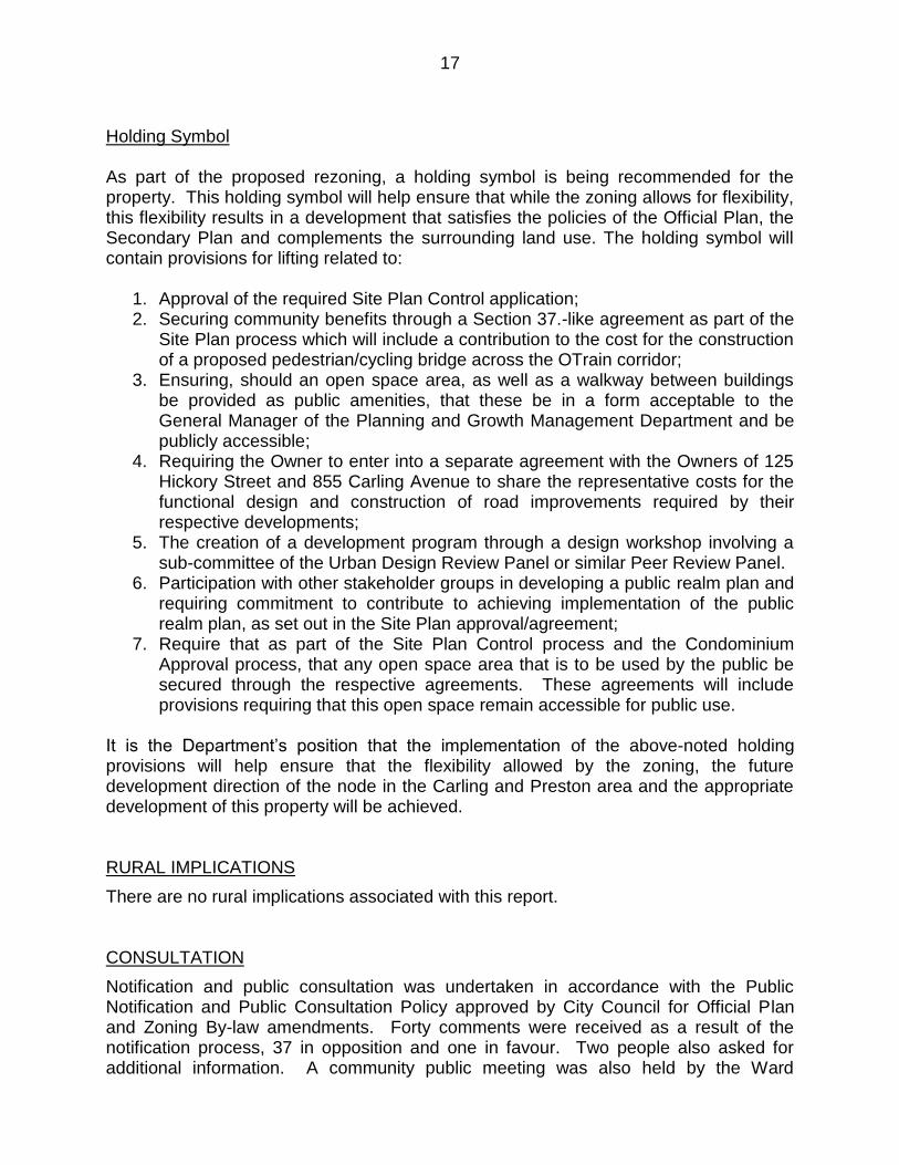
Holding Symbol As part of the proposed rezoning, a holding symbol is being recommended for the property. This holding symbol will help ensure that while the zoning allows for flexibility, this flexibility results in a development that satisfies the policies of the Official Plan, the Secondary Plan and complements the surrounding land use. The holding symbol will contain provisions for lifting related to:
1. Approval of the required Site Plan Control application; 2. Securing community benefits through a Section 37.-like agreement as part of the
Site Plan process which will include a contribution to the cost for the construction of a proposed pedestrian/cycling bridge across the OTrain corridor;
3. Ensuring, should an open space area, as well as a walkway between buildings be provided as public amenities, that these be in a form acceptable to the General Manager of the Planning and Growth Management Department and be publicly accessible;
4. Requiring the Owner to enter into a separate agreement with the Owners of 125 Hickory Street and 855 Carling Avenue to share the representative costs for the functional design and construction of road improvements required by their respective developments;
5. The creation of a development program through a design workshop involving a sub-committee of the Urban Design Review Panel or similar Peer Review Panel.
6. Participation with other stakeholder groups in developing a public realm plan and requiring commitment to contribute to achieving implementation of the public realm plan, as set out in the Site Plan approval/agreement;
7. Require that as part of the Site Plan Control process and the Condominium Approval process, that any open space area that is to be used by the public be secured through the respective agreements. These agreements will include provisions requiring that this open space remain accessible for public use.
It is the Department’s position that the implementation of the above-noted holding provisions will help ensure that the flexibility allowed by the zoning, the future development direction of the node in the Carling and Preston area and the appropriate development of this property will be achieved. RURAL IMPLICATIONS
There are no rural implications associated with this report. CONSULTATION
Notification and public consultation was undertaken in accordance with the Public Notification and Public Consultation Policy approved by City Council for Official Plan and Zoning By-law amendments. Forty comments were received as a result of the notification process, 37 in opposition and one in favour. Two people also asked for additional information. A community public meeting was also held by the Ward

18
Councillor on June 28, 2012 at the Civic Hospital. Approximately 20 people attended the meeting. A summary of the public comments received and a response to them can be found in Document 4. COMMENTS BY THE WARD COUNCILLOR
Councillor Hobbs is aware of the application. LEGAL IMPLICATIONS
If this matter is appealed to the Ontario Municipal Board, it is anticipated that a four day hearing would result. Should the recommendation be adopted, the hearing could be conducted within staff resources. If the application is refused, reasons must be provided and in the event of an appeal, it would be necessary to retain an external planner and possibly a transportation consultant to speak to the issue of traffic impacts. The costs would range from approximately $30,000 (planner only) to $60,000 if a transportation consultant is required. RISK MANAGEMENT IMPLICATIONS
There are no risk management implications associated with this report. FINANCIAL IMPLICATIONS
If the amendment is carried and an appeal is brought before the Ontario Municipal Board, staff resources would be utilized to defend Council’s position. In the event the amendment is not carried and an appeal is launched, an external planner and possibly a transportation consultant would need to be retained at an estimated cost of $30,000 (planner only) to $60,000 (planner and transportation consultant). Funds are not available from within existing resources and the expense would impact Planning and Growth Management’s 2013 operating status. ACCESSIBILITY IMPACTS
There are no accessibility impacts associated with this report. ENVIRONMENTAL IMPLICATIONS
There are no environmental implications associated with this report. TECHNOLOGY IMPLICATIONS
There are no technology implications associated with this report.

19
TERM OF COUNCIL PRIORITIES
C1 – Contribute to improvement of quality of life. C3 – Provide a compelling vibrant destination GP3 – Make sustainable choices TM2 – Maximize density in and around transit stations TM3 – Provide infrastructure to support mobility choices IC2 – Improve Parks and Recreation APPLICATION PROCESS TIMELINE STATUS
The application was not processed by the "On Time Decision Date" established for the processing of Zoning By-law amendments due to a need to hold a community information meeting in the community. SUPPORTING DOCUMENTATION
Document 1 Location Plan Document 2 Proposed Official Plan Amendment Document 3 Details of Recommended Zoning Document 4 Consultation Details Document 5 Renderings DISPOSITION
City Clerk and Solicitor Department, Legislative Services to notify the owner, applicant, Ottawa Scene Canada Signs, 1565 Chatelain Avenue, Ottawa, ON K1Z 8B5, Ghislain Lamarche, Program Manager, Assessment, Financial Services Branch (Mail Code: 26-76) of City Council’s decision. Planning and Growth Management to prepare the implementing by-laws, forward to Legal Services and undertake the statutory notification. Legal Services to forward the implementing by-laws to City Council.
20
LOCATION MAP DOCUMENT 1

21
PROPOSED OFFICIAL PLAN AMENDMENT DOCUMENT 2
OFFICIAL PLAN AMENDMENT NO. XX MODIFICATION DU PLAN DIRECTEUR To the Official Plan of the City of Ottawa LAND USE
Utilisation du sol

22
______________________________________________________________________
INDEX ______________________________________________________________________
THE STATEMENT OF COMPONENTS PART A – THE PREAMBLE does not constitute part of the Amendment. Purpose Location Basis PART B – THE AMENDMENT consisting of the following text constitutes Amendment. No. __ to the Official Plan of the City of Ottawa. Introduction Details of the Amendment Implementation and Interpretation Schedule A of Amendment __ – Official Plan of the City of Ottawa

23
PART A – THE PREAMBLE Purpose The purpose of this Amendment is to change the Land Use designation of the property from Residential – Low Profile to Residential – High Profile in the Preston-Champagne Secondary Plan. The Amendment will help facilitate the development of the property with a 22 storey and a 25 storey apartment building. Location The lands affected by this Amendment are located mid-block on the east side of Champagne Avenue South, north of Hickory Street. The lands are municipally known as 101 Champagne Avenue South. Basis BACKROUND
The subject property is located on the east side of Champagne Avenue South, mid-way between Beech Street and the dead-end portion of Hickory Street. The site is the former location of the Ottawa Humane Society. Adjacent to the north is a City park, known as Ev Tremblay Park while to the east is the OTrain Corridor. To the west is a 14-storey high-rise apartment building and a new 12-storey apartment building while to the south is a vacant parcel of land that has recently been rezoned to allow a mixed-use building consisting of two towers, one being 16-storeys and the other 20-storeys. The Official Plan designates the subject property as ―Mixed-Use Centre‖ and the Preston-Champagne Secondary Plan designates the land as ―Residential – Low Profile‖. The Owner of the subject property is intending to amend the current secondary plan designation and zoning so they can demolish the building existing on the property and construct two high-rise apartment towers. One tower is proposed to be 71 metres high (22-storeys) and the other 81 metres (25-storeys) high. The development concept developed by the applicant includes the provision of publicly accessible open space approximately 25 metres square in the northwest corner of the subject property to augment the adjacent Ev Tremblay Park and public access through the site to the OTrain pathway located east of the site. Any public access to open space and through the site will be formalized through the Site Plan Control process. In order to help facilitate the proposed development, the property Owner will require an amendment to both the Preston-Champagne Secondary Plan and the Zoning By-law. Context The Official Plan designates the subject property as Mixed-Use Centre and forms part of the larger Carling-Bayview Mixed-Use Centre. Lands having a Mixed-Use Centre designation are situated at strategic locations across the City and act as focal points of activity, not only for their local community but for the city at large. They are a critical element to the City’s growth strategy. Mixed-Use Centres are limited in number and represent opportunities for substantial growth. The density of development within

24
Mixed-Use Centres is to take advantage of the opportunities offered by transit and ease of access on foot and by bicycle. Mixed-use Centres will contribute to the diversity of land uses in the immediate area and foster the creation of vibrant centres of activity. The Official Plan establishes minimum density targets within Mixed-Use Centres, in order to help ensure that they develop at densities envisioned by the Official Plan. There are no maximum densities associated with Mixed-Use Centres. The proposed amendment to the Preston Champagne Secondary Plan and the proposed rezoning are in keeping with the intent of the Mixed-Use Centre policies as it provides for a high-rise, high-density residential development at a location where it is anticipated to occur. Such development, as demonstrated by the development concept submitted with the application will in the Department’s view enhance the character, vibrancy and functioning of the area as a unique dynamic place and contribute to the diversity of land uses in the area. The development concept, if pursued, would provide for significant open space areas that would add a unique element to the public realm of the overall node through the addition of public accessible land to augment the existing adjacent park and increase pedestrian connections to the OTrain corridor. The Mixed-Use Centre policies also indicate that when apartments are constructed, it is to be done at a medium or high density and the density of the development that is provided is to be at least that of the minimum density target established for the Mixed-Use Centre. In this instance, the Minimum Density Target for the Carling-Bayview Mixed-Use Centre is 200 people and jobs per hectare. As such, given that the site occupies a land area of approximately 3,310 square metres, it would be required to provide a minimum of 66 people and jobs per hectare. The development concept prepared by the applicant is intended to provide approximately 252 units with a density of approximately 1,233 people and jobs per hectare. The Official Plan indicates that high density development should be located within 400 metres of a rapid transit station or along an arterial roadway with all day transit. The subject property satisfies this direction as it is located approximately 325 metres walking distance from the Carling OTrain station, which in the future, will be a twin-track light-rail station. The current OTrain service is being upgraded to eight minute frequency starting in 2014. The proximity of the subject property to this station, as well as Ev Tremblay Park and the amenities of Preston Street to the east, helps support the use of transportation alternatives other than a private automobile. Furthermore, the construction of high-rise residential on the subject site, along with other recently approved residential and mixed-use developments in the immediate area, will help achieve the goal of a Mixed-Use Centre that provides a vibrancy of uses and amenities for the surrounding community and the City at large. In addition to the policies referenced above, the Official Plan also indicates that an application for development will be evaluated with reference to the Design Objectives and Principles in Section 2.5.1. and the compatibility policies contained in Section 4.11. The Official Plan acknowledges that introducing new development in existing areas that have developed over a long period of time requires a sensitive approach and a respect for a community’s established characteristics. Urban design is an important component

25
of that sensitive approach and is concerned with how buildings, landscapes and adjacent public spaces look and function together. Good urban design and quality architecture can create lively community places with distinctive character and meaningful connections between the existing surroundings. The Official Plan provides guidance on measures that will mitigate the impact of new development by helping to achieve compatibility of form and function. Allowing for flexibility and variation that complements the character of existing communities is central to successful intensification. In general terms, compatible development means development that, although it is not necessarily the same as or even similar to existing buildings in the vicinity, nonetheless enhances an established community and coexists with existing development without causing undue adverse impact on surrounding properties. It fits well within its physical context and works well among those functions that surround it. Generally speaking, the more a new development can incorporate the common characteristics of its setting in its design, the more compatible it will be. Nevertheless, a development can be designed to fit and work well in a certain existing context without being ―the same as‖ the surrounding development. Renderings of the development concept submitted with the applications are provided in Document 5 of this submission. As noted, in the background discussion, this development concept is seen as acceptable and can be a positive and unique element of the larger Preston/Carling Node. Through a Design Charrette held in September 2012 to determin how the Carling Preston node may evolve in the future, it has also been determined that other options for developing the site with high-rise residential may also work well and potentially make other positive contributions to establishing the node as a unique and dynamic place. The analysis presented in this submission on how the policies in Section 2.5.1. and Section 4.11 are satisfied are focused on the development concept depicted in Document 5 with reference to how a modified development concept could also advance the design and compatibility policies and objectives of the Official Plan. Section 2.5.1. contains seven design objectives relating to how built environment should be addressed as the City matures and evolves. These Design Objectives are broadly stated and are to be applied within all land use designations from the broad citywide perspective down through to the neighbourhood, street, site and finally at the building perspective. The development concept submitted with the subject applications has been evaluated in relation to this section of the Official Plan, and the design objectives that are relevant to the concept and a modified development concept that would also provide for high-rise residential development. In addition to the design policies contained in the Official Plan, the proposed Official Plan Amendment and rezoning must also be evaluated in relation to the compatibility policies in Chapter Four of the Official Plan, namely Section 4.11. While certain policies, such as loading, lighting and the location of vehicular access are issues for Site Plan Control, there are other specific policies in this section that give direction to evaluating rezoning proposals relating to building profile and compatibility, traffic, sunlight and microclimate. These, as discussed in the staff report related to this amendment have been addressed.

26
In addition to the policies of the Primary Plan, the subject property is also subject to the policies of the Preston-Champagne Secondary Plan. This Secondary Plan seeks to reinforce the area as a diverse inner city neighbourhood with a broad mix of uses. It will allow major redevelopment that transitions to existing lower profile residential areas. The southwest quadrant, where the subject property is located, will incorporate both new office and residential development. The Northwest edge of this area will be retained as a low profile residential area to provide transition to the existing low profile residential areas further to the north and west. The Secondary Plan designates the subject lands as Residential - Low Profile. Lands having this designation are intended to be predominantly occupied by low profile residential uses in order to help preserve its residential character. The lands adjacent to the north are occupied by Ev Tremblay Park and as such are designated Open Space. Lands adjacent to the south and southwest are designated Residential - High Profile. Adjacent lands to the east are occupied by the OTrain Corridor and are designated Greenway Linkage. Lands to the west, directly across Champagne Avenue South that accommodate high rise apartments are not designated by the Secondary Plan. The property Owner is asking to re-designate the subject property to Residential – High Profile in the Secondary Plan. As mentioned, the intent of the Residential Low-Profile Designation is to ensure that there are developments within the Secondary Plan’s boundary which are low profile in nature. Indeed, there is an area with such a designation to the north, on the west side of the railway tracks, and also separate Low Profile areas to the east and north on the east side of the railway tracks. These residential low-profile areas are much larger in area and exhibit a more cohesive low profile fabric than the subject property. In fact, with the recent redesignation of 125 Hickory Street and 100 Champagne Avenue South, from Residential Low-Profile to Residential – High Profile, the Low Profile Designation in this specific area of the Secondary Plan now only applies to the subject property. The recent re-designations represent a rethinking of the desired development form in this area to advance policies of Volume I of the Official Plan for Mixed-Use Centres. The proposed amendment to High Profile will complement these recent re-designations, contribute to the evolving environment and consolidate this high profile node to the south of the park, with the park offering an area of transition to the Low Profile designated areas to the north. As well, since the redesignation of the subject lands removes only a limited area from the total land area designated Residential – Low Profile, it is the Department’s position that the overall policy directive of having areas occupied by low profile developments is not jeopardized and the change in development potential for this site is appropriate. Consideration should also be given to the fact that the former use of the property as an animal shelter was more institutional in nature and the proposed Official Plan Amendment does not result in a loss of lands that are currently occupied by low profile residential uses. At the time of the completion of the Preston-Champagne Secondary Plan, in the early 1990s, the use of the existing rail line for rapid transit had not been contemplated and therefore, proximity to the OTrain station at Carling (which opened in 2001) was not

27
used as a factor in determining the designation of the subject lands. In considering the site location is about 400 metres current walking distance from the OTrain Station, a more intense form of development that takes advantage of this proximity to rapid transit. PART B – THE AMENDMENT 1. Introduction
All of this part of this Document entitled Part B – The Amendment consisting of the following text and the attached Schedule A, constitutes Amendment No. ___ to the Official Plan of the City of Ottawa. 2. Details of the Amendment The Preston Champagne Secondary Plan of the City of Ottawa Official Plan Volume 2A is hereby amended as follows:
2.1. Schedule L ―Preston-Champagne Land Use‖ is amended to include the following change as shown on Schedule A attached hereto:
i) Redesignate the lands known municipally as 101 Champagne
Avenue South from Residential Low Profile to Residential High Profile.
2.2 Section 6.2 ―Vision‖ is amended by replacing the following sentence under
the paragraph entitled ―Southwest Quadrant‖: ―High profile residential development is permitted on the north east corner
of Hickory Street and Champagne Avenue‖
With the following: ―High profile residential development is permitted on the east side of
Champagne Avenue South, between Ev Tremblay Park and Hickory Street.
3. Implementation and Interpretation Implementation and Interpretation of this Amendment shall be made having regard to applicable policies set out in Volume 1 – Primary Plan of the City of Ottawa Official Plan.

28

29
DETAILS OF RECOMMENDED ZONING DOCUMENT 3 Proposed Changes to Comprehensive Zoning By-law 1.Rezone the lands shown in Document 1 from R4M[924] to R5B[924]-h
1. Amend Exception 924 by: a. Replacing the text ―R4M[924]‖ with ―R5B[924]-h‖ in Column II; b. Deleting the existing text in Column III; c. Adding to Column IV text similar in effect to the following: ―- all uses
except existing uses and residential use buildings up to nine storeys, until the holding symbol is removed‖; and,
d. Adding to Column V text similar in effect to the following: A) Section 65 does not apply to a canopy or similar projection and
such a projection may project to a lot line. B) The minimum front yard setback is 2.0 metres. C) A walkway in the front yard may have a maximum width of 2.0
metres. D) Notwithstanding subsection 109(12), areas required to be
landscaped with soft landscaping in the front yard may be landscaped with either soft or hard landscaping as determined through the site plan approval process.
E) The minimum rear yard setback may be 0 metres. F) The minimum northerly interior side yard setback may be 0 metres. G) The minimum southerly interior side yard setback may be 2.5
metres H) A maximum of two residential use buildings containing apartment
dwelling mid-high high-rises are permitted on the property. When only one building containing an apartment dwelling mid-high rise is located on the property, it may have a maximum of two towers.
I) One building may have a height of 81 metres and the other may have a height of 71 metres. Where only one building is located on the lot, but that building has two towers, one may be no more than 81 metres in height and the other may be no more than 71 metres in height. If one high rise building with one tower is constructed on the property it may be 81 metres high.
J) Visitor parking shall be provided at a rate of 0.083 spaces per dwelling unit after the first 12 units.
K) Amenity space with a maximum height of 5.0 metres may project above the allowable building height.
L) The maximum allowable gross floor area of development on the subject property is 32 750 square metres.
M) A minimum of 625 square metres of landscaped open space must be provided on the property.
N) The minimum separation distance between two buildings on the same lot, excluding permitted projections, is 10.9 metres.
O) The minimum separation distance between two towers of the same building, excluding permitted projections, is 10.9 metres.

30
P) The holding symbol may only be removed at such time as: 1. An application for Site Plan Control Approval has been
approved; and which approval includes conditions related to the following: i. securing community benefits via a Section 37
like Agreement, which will include a contribution to the cost for the construction of a proposed pedestrian/cycling bridge across the OTrain corridor;
ii. ensuring that any open space, as well any walkway between any two buildings on the lot that is to be provided as a public amenity for public use and access, is in a form acceptable to the General Manager of the Planning and Growth Management Department and is publicly accessible;
iii. the requiring that the Owner enter into a separate agreement with the Owners of 125 Hickory Street and 855 Carling Avenue to share the representative costs for the functional design and construction of road improvements required by their respective developments as identified in the Transportation Impact Study provided as part of rezoning application;
iv. confirming the final development program to be approved through the site plan approval process through a design workshop involving a sub-committee of the Urban Design Review Panel or similar Peer Review Panel;
v. participating with other stakeholder groups in developing a public realm plan and requiring commitment to contribute to achieving implementation of the public realm plan, to be set out in the Site Plan approval/agreement;
vi. Requiring as part of the Site Plan Control Approval Process and the Condominium Approval Process, that any open space area to be used by the public be secured through the respective agreements. These agreements will include provisions requiring that this open space remain accessible for public use.

31
CONSULTATION DETAILS DOCUMENT 4 Notification and public consultation was undertaken in accordance with the Public Notification and Public Consultation Policy approved by City Council for Official Plan and Zoning By-law amendments. Forty comments were received as a result of the notification process, 37 in opposition and one in favour. Two people also asked for additional information. A community information meeting was also held by the Ward Councillor on June 28, 2012 at the Civic Hospital. Approximately 20 people attended the meeting. A summary of the public comments received and a response to them are provided below. SUMMARY OF PUBLIC INPUT Concerns Expressed Over the Proposal
1. The proposed buildings are too high for our neighbourhood, 10 to 14-storeys would be more appropriate and in line with other recent developments. Response As presented in this report, the policies of the Official Plan designate this property as Mixed-Use Centre, which offer some of the greatest opportunities for development, including buildings high rise buildings.
2. The proposed buildings will block the sunlight to the park for a good portion of the day and the year. Response Sun/shadow studies prepared show that the greatest impact occurs in the cooler months of the year with the impact being lower in the peak summer months. The slimmer floor plate that the rezoning would provide for allows the shadows to move more quickly across the park, with the majority of the park always being in sunlight and by the early afternoon there being no impact at all.
3. Shouldn’t the height of a building step down away from the transit node? Response While it is expected that the tallest buildings will be located closest to the Carling rapid transit station, the progression in building height away from the station does not need to be strictly linear and can accommodate variations.
4. It seems irresponsible to continue granting all the builders requests without a real vision for the area.

32
Response The Official Plan provides a vision for the area and as presented in this report it is that of a higher density Mixed-Use Centre. The Official Plan also provided for development of properties without a Community Design Plan, as long as the development is in compliance with the policies of the designation. As presented in this report, this is the case.
5. Can the City’s infrastructure handle the proposed development? Response The applicant has provided reports, which have been verified by City staff that the proposed development can be accommodated by the City’s Infrastructure.
6. The traffic in the area is already bad and this proposal, along with the other condominiums being constructed in the area will only make it worse. Response As indicated, the residential development under the proposed zoning would represent only a 6% increase in traffic volumes and along with the other recently approved proposals in the immediate area, only minor changes are required to existing turn lanes. These will be addressed through the Site Plan Control process.
7. The traffic study provided contains significant factual errors and questionable assertions and assumptions. Response The traffic study has been reviewed and approved by City Transportation staff.
8. The proposed buildings will negatively affect the resale value of our homes. Response There is no evidence that high rise residential development for the site will result in a decline in the values of existing homes. In fact, based on experiences such as in Westboro, which has seen a large amount of redevelopment, housing values have increased.
9. It is obvious that by the recent granting of other proposals in the area that the feelings of residents do not rank high on the list of concerns of City staff.

33
Response City staff respects the concerns of area residents and make recommendations to City Council based on relevant Official Plan policies and sound planning principles.
10. Creating a high-rise concrete jungle will not be positive for our neighbourhood. Response Development of the site will integrate with public open space and may also augment public open space in the area.
11. This proposal is contrary to the City’s Zoning rules and should be refused. Response The property owner has a right to file a zoning amendment and the appropriateness of the request is evaluated in relation to the relevant City policies and guidelines.
12. The visual appeal of the building could be improved to make it fit better in the neighbourhood. Response Any development of the site will be subject to both design review and site plan approval. The details of the final design for any development of the site would be determined through these processes. It is the Department’s position, as demonstrated by the development concept submitted by the applicant, that high rise development can be achieved to then create a positive visual appeal that will make it a successful component of the surrounding neighbourhood.
13. There should be a podium to the building that contains commercial uses. Response Ground floor commercial was not seen as a viable proposition for this site by the Owner. Staff agree with this and further note that the Preston Street commercial area is located immediately to the east, which is the commercial focus for the area.
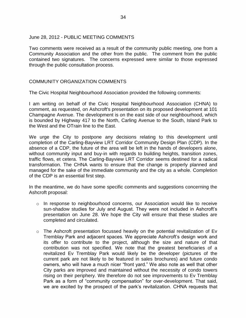
34
June 28, 2012 - PUBLIC MEETING COMMENTS Two comments were received as a result of the community public meeting, one from a Community Association and the other from the public. The comment from the public contained two signatures. The concerns expressed were similar to those expressed through the public consultation process. COMMUNITY ORGANIZATION COMMENTS The Civic Hospital Neighbourhood Association provided the following comments: I am writing on behalf of the Civic Hospital Neighbourhood Association (CHNA) to comment, as requested, on Ashcroft's presentation on its proposed development at 101 Champagne Avenue. The development is on the east side of our neighbourhood, which is bounded by Highway 417 to the North, Carling Avenue to the South, Island Park to the West and the OTrain line to the East. We urge the City to postpone any decisions relating to this development until completion of the Carling-Bayview LRT Corridor Community Design Plan (CDP). In the absence of a CDP, the future of the area will be left in the hands of developers alone, without community input and buy-in with regards to building heights, transition zones, traffic flows, et cetera. The Carling-Bayview LRT Corridor seems destined for a radical transformation. The CHNA wants to ensure that the change is properly planned and managed for the sake of the immediate community and the city as a whole. Completion of the CDP is an essential first step. In the meantime, we do have some specific comments and suggestions concerning the Ashcroft proposal:
o In response to neighbourhood concerns, our Association would like to receive sun-shadow studies for July and August. They were not included in Ashcroft’s presentation on June 28. We hope the City will ensure that these studies are completed and circulated.
o The Ashcroft presentation focussed heavily on the potential revitalization of Ev
Tremblay Park and adjacent spaces. We appreciate Ashcroft’s design work and its offer to contribute to the project, although the size and nature of that contribution was not specified. We note that the greatest beneficiaries of a revitalized Ev Tremblay Park would likely be the developer (pictures of the current park are not likely to be featured in sales brochures) and future condo owners, who will have a much nicer ―front yard.‖ We also note as well that other City parks are improved and maintained without the necessity of condo towers rising on their periphery. We therefore do not see improvements to Ev Tremblay Park as a form of ―community compensation‖ for over-development. That said, we are excited by the prospect of the park’s revitalization. CHNA requests that

35
area residents and the Civic Hospital Area Parks and Recreation Committee be consulted before work design and construction work begins.
o The community vision that informs the work of the Carling Bayview Light Rail
Transit Corridor CDP calls for the establishment of a clear boundary between the ―established neighbourhood‖ and the ―development area,‖ including a transitional zone within the latter. We consider such a boundary to be vitally important to the neighbourhood, and we believe the 101 Champagne site should been designated as the transitional zone.
o CHNA is greatly concerned about the additional traffic that would be generated by the 101 Champagne towers and other developments in the area, including 100 Champagne, 125 Hickory, 855 Carling, and the two Domicile developments between Loretta Avenue and Breezehill Avenue.
o We understand that those developments will include a total of about 1,500 parking spaces and could — according to a November 2011 study by Delcan — generate traffic volumes of up to 800 vehicles per hour the during morning and evening peaks. We reiterate our basic position: the scale of development being proposed is entirely inappropriate for an established residential neighbourhood. We urge the City to mitigate the impacts of this potential traffic tsunami on our neighbourhood streets through the installation of barriers and diversions, and through other means that will calm traffic and encourage motorists to use Carling Avenue and other arterials. Of particular concern is the potential impact on Hickory and Beech streets, which could be overwhelmed by the traffic generated by these developments. The City must reach out to the community to discuss and resolve these issues, and it should press the developers to contribute to traffic mitigation efforts. This should include but not be limited to $30 thousand for a traffic light sensor at Carling and Champagne and additional signs which would direct drivers to take Carling and then Queensway ramps at Rochester or Westgate, as opposed to the already congested Parkdale ramps
In closing, I would like to express our appreciation to Ashcroft for sharing and discussing its plans with the community, and I thank you for your consideration. Response to Comments from the Civic Hospital Neighbourhood Association The City has a legislative requirement to process planning applications that are filed with the City. As well, while an area of the City may be involved in the Community Design Plan process, there are existing policies in place within the Official Plan to guide development in accordance with the direction established by City Council. As such, any development will be evaluated in relation to those policies. Additional sun shadow diagrams for the months of July and August have been provided and are located on the City’s Development Applications webpage. As part of the Site Plan Control process, funds will be collected through cash-in-lieu of parkland.

36
As mentioned in this report, Ev Tremblay Park provides the transition from this developable area to the established residential neighbourhood. Transition is not specific to an incremental change in building height, but can also include such things as building materials and separation distance. As mentioned in the Community Traffic Report prepared for this proposal, the list of developments taking place in this general area will require modifications to the existing road network, with the addition of such things as turn lanes. Changes to the existing road network will be addressed as part of the Site plan Control process.

37
RENDERINGS DOCUMENT 5