report to/rapport au : planning committee comité de...
TRANSCRIPT

57
Report to/Rapport au :
Planning Committee Comité de l'urbanisme
and Council / et au Conseil
June 22, 2012 22 juin 2012
Submitted by/Soumis par : Nancy Schepers, Deputy City Manager/Directrice municipale adjointe,Planning and Infrastructure/Urbanisme et Infrastructure
Contact Person / Personne ressource:
John Smit, Manager/Gestionnaire, Development Review-Urban Services / Examen des projets d'aménagement-Services urbains Planning and Growth Management/Urbanisme
et Gestion de la croissance (613) 580-2424, 13866 [email protected]
Rideau-Vanier (12) Ref N°: ACS2012-PAI-PGM-0182
SUBJECT:
ZONING AND COMMUNITY DESIGN PLAN REVISION - 222 BEECHWOOD AVENUE, 8 JOLLIET AVENUE AND 9 MARQUETTE AVENUE
OBJET :
MODIFICATION DE ZONAGE ET RÉVISION DU PLAN DE CONCEPTION COMMUNAUTAIRE – 222, AVENUE BEECHWOOD, 8, AVENUE JOLLIET ET 9, AVENUE MARQUETTE
REPORT RECOMMENDATIONS That the Planning Committee recommend Council: 1. Approve a revision to the Beechwood Community Design Plan to change
Sections 2.2.3 and 2.4.1 and Figure 11, to permit a high-rise building of up to 34.0 metres in height on 222 Beechwood Avenue, 8 Jolliet Avenue and 9 Marquette Avenue as detailed in Document 4 and as shown in Documents 5; and
2. Approve an amendment to the Zoning By-law 200-250 to change the zoning
of 222 Beechwood Avenue from TM S241, Traditional Mainstreet and the zoning of 8 Jolliet Avenue and 9 Marquette Avenue from TM H(15) to a new TM (XXX) S241 as detailed in Document 2 and as shown in Documents 1 and 3.
58
RECOMMANDATIONS DU RAPPORT Que le Comité de l’urbanisme recommande ce qui suit au Conseil : 1. Approuver une révision au Plan de conception communautaire de
Beechwood, approuvé par le Conseil le 27 septembre 2006, en modifiant les articles 2.2.3 et 2.4.1 ainsi que la figure 11, de manière à autoriser la construction d’un immeuble élevé pouvant atteindre une hauteur de 34,0 mètres sur la propriété visée, tel qu’exposé en détail dans le document 4 et illustré dans le document 5; et
2. Approuver une modification au Règlement de zonage 200-250 afin de modifier le zonage du 222, avenue Beechwood de TM S241, Zone de rue principale traditionnelle, et de faire passer le zonage du 8, avenue Jolliet et du 9, avenue Marquette de TM H(15) à TM (XXX) S241, tel qu’exposé en détail dans le document 2 et illustré dans les documents 1 et 3.
EXECUTIVE SUMMARY
Context This application is for the re-zoning of the property located at 222 Beechwood Avenue, 8 Jolliet Avenue and 9 Marquette Avenue, which is on the east side of Beechwood Avenue between Jolliet and Marquette Avenues, towards the north end of the “Beechwood village” area. The application also includes a request to amend the Beechwood Community Design Plan (BCDP), which limits development on the property to “Low-Rise Intensification.” There is currently a TM S241 zone on the westerly portion of the property and a TM H(15) zone on the easterly portion facing Beechwood Avenue. Both zones allow for a mix of commercial and residential uses with the easterly portion allowing for a maximum building height of 15 metres, a 20 metre maximum in the centre, and a maximum building height of 77.0 metres above sea level on the west side to protect views to Parliament Hill from the Beechwood Cemetery. The recommended zoning amendment will permit a building with a maximum height of 34.0 metres to accommodate an 11-storey mixed commercial-residential building, with no increase in height within the currently protected Parliament Hill view-shed. This reflects a slight revision to the applicant’s original request for a re-zoning to permit a building 37 metres high. The proposed re-zoning reduces the required set-backs along Jolliet and Marquette Avenues as part of a specific minimum yards and heights schedule. The proposed re-zoning also reduces commercial parking and combines it with residential visitors parking, allows for limited roof amenity areas, and limits some balcony and other projections.

59
Planning Analysis The recommended re-zoning and revisions to the BCDP have been evaluated in terms of the City’s Official Plan (OP), the provisions of the BCDP and the Urban Design Guidelines for High-Rise Housing. Any specific development proposal for the property will also be subject to more detailed review through the Site Plan Control approval process. The revision to the BCDP and the rezoning is in keeping with the fundamental Guiding Principles and Objectives of the OP, particularly those dealing with a Capital City, Development in Harmony with the Environment, a Focus on Walking, Cycling and Transit, Complete Communities, and Fiscal Responsibility. The proposed re-development upholds the key components of the Strategic Approach of the OP. In particular, the application has been considered in terms of the intent of Section 2 to achieve substantial intensification along Mainstreets as designated growth areas. The policy intents of Section 2.4.1 of the OP, in conjunction with related sections of Section 4.11, for achieving good design and development that is complementary to the surrounding existing and planned built environment have been applied to the application, including preliminary review by the Urban Design Review Panel. The proposed redevelopment satisfies the intent of intensification and design policies of the OP and those promoting reuse of a “brown-field” site. The subject property is designated Traditional Mainstreet on Schedule B of the OP. The recommended rezoning addresses the policies of the Traditional Mainstreet, and the intent of the recommended revisions to the BCDP; the BCDP revisions are also consistent with the OP policies for intensification along Mainstreets. The related development will provide for uses at grade to animate the mainstreet and enhance the pedestrian environment while adding over 130 new residential units to this node within the BCDP. A contribution of funds from the applicant for improvements to the nearby Optimiste Park is anticipated through the related site plan application. Public Consultation/Input There was public response to the circulation of the initial re-zoning proposal for a 37 metre high building, including two community groups. All individual responses were in opposition, except five indicating support. The Vanier Community Association supports the application and feels the applicant should help make improvements to the nearby Optimiste Park. The Rockcliffe Park Residents Association is opposed to the application. Opposition to the proposal focused on the building height, parking and traffic concerns, community compatibility and building design, and lack of compliance with the intent of the Beechwood Community Design Plan (BCDP). The current proposal and the recommendations for approval have been evaluated as per the existing policies for the area, including those that pertain to the concerns raised by the public. The Department believes the proposed revision to the BCDP and the re-zoning are in keeping with the overall intent of the OP and merit approval.

60
RÉSUMÉ Contexte La demande vise à modifier le zonage de la propriété située au 222, avenue Beechwood, au 8, avenue Jolliet et au 9, avenue Marquette, qui se trouve du côté est de l’avenue Beechwood, entre les avenues Jolliet et Marquette, vers l’extrémité nord du secteur du « village de Beechwood ». La demande concerne également une modification au Plan de conception communautaire de Beechwood (PCCB), qui limite l’aménagement de la propriété à une « densification au moyen de bâtiments de faible hauteur ». On retrouve actuellement un zonage TM S241 dans la partie ouest de la propriété et un zonage TM H(15) dans la partie est, qui donne sur l’avenue Beechwood. Ces deux zonages permettent une variété d’utilisations commerciales et résidentielles, la hauteur maximale de bâtiment étant fixée à 15 mètres dans la partie est, à 20 mètres au centre et à 77,0 mètres du côté ouest, afin de protéger les points de vue sur la colline du Parlement depuis le cimetière Beechwood. La modification de zonage recommandée permettrait la construction d’un bâtiment polyvalent commercial et résidentiel d’une hauteur maximale de 34,0 mètres et de onze étages, sans accroissement de hauteur dans le bassin visuel actuellement protégé de la colline du Parlement. Il s’agit d’une légère révision faite à la demande originale de modification de zonage faite par le requérant en vue de permettre la présence d’un bâtiment d’une hauteur de 37 mètres. La modification de zonage proposée réduirait les retraits requis le long des avenues Jolliet et Marquette, aux termes d’une annexe spécifique sur les retraits et les hauteurs minimaux. La modification de zonage proposée réduirait également la superficie du parc de stationnement commercial et l’associerait au parc de stationnement résidentiel pour visiteurs, permettrait des aires d’agrément limitées sur toiture et limiterait certains balcons et autres projections. Analyse de planification La modification de zonage et les révisions recommandées au PCCB ont été évaluées au regard du Plan officiel (PO) de la Ville, des dispositions du PCCB et des Lignes directrices d’esthétique urbaine pour les habitations de grande hauteur. Tout projet d’aménagement en particulier de la propriété fera également l’objet d’un examen plus détaillé dans le cadre du processus de réglementation du plan d’implantation. La révision du PCCB et la modification de zonage sont considérées conformes aux principes directeurs et aux objectifs fondamentaux du PO, en particulier à ceux portant sur une capitale, sur les aménagements en harmonie avec l’environnement, favorisant la marche, le vélo et le transport en commun, sur les collectivités complètes et sur la responsabilité financière. Le réaménagement proposé respecte les éléments clés de l’approche stratégique du PO. Plus particulièrement, la demande a été examinée en tenant compte de l’objectif décrit à la Section 2 et qui consiste à densifier considérablement les rues principales comme autant de secteurs de croissance désignés. Les lignes de conduite de la Section 2.4.1 du PO, conjuguées aux articles pertinents de la Section 4.11, relatives à

61
la réalisation de conceptions et d’aménagements de qualité et complémentaires du milieu bâti environnant existant et prévu, ont été appliquées à la demande, y compris un examen préliminaire du Comité d’examen du design urbain de la Ville. Le réaménagement proposé est conforme aux politiques de densification et de conception du PO et à celles favorisant la réutilisation des friches industrielles. La propriété visée est désignée rue principale traditionnelle dans l’annexe B du PO. La modification de zonage proposée tient compte des politiques relatives aux rues principales traditionnelles et des révisions recommandées au PCCB; les révisions apportées au PCCB sont par ailleurs cohérentes avec les politiques du PO en matière de densification des rues principales. L’aménagement qui y serait réalisé offrira des utilisations en rez-de-chaussée qui animeront la rue principale et qui mettront en valeur le domaine piétonnier tout en ajoutant plus de 130 nouvelles unités d’habitation dans ce nœud du PCCB. Une contribution financière du requérant, destinée à améliorer le parc Optimiste situé à proximité, est prévue dans le cadre de la demande connexe de réglementation du plan d’implantation. Consultation publique / commentaires Des commentaires des membres du public, notamment deux groupes communautaires, ont été émis par suite de la diffusion de la demande initiale de modification de zonage destinée à la construction d’un immeuble d’une hauteur de 37 mètres. Tous les commentaires individuels étaient opposés, à l’exception de cinq en faveur du projet. L’Association communautaire de Vanier appuie la demande et estime que le requérant contribuera à améliorer le parc Optimiste situé à proximité. La Rockcliffe Park Residents Association s’oppose à la demande. L’opposition manifestée concernait la hauteur de l’immeuble, le stationnement et la circulation, la compatibilité du projet dans la collectivité, la conception du bâtiment et le manque de conformité aux objectifs du Plan de conception communautaire de Beechwood (PCCB). La proposition actuelle et les recommandations en vue de son approbation ont été évaluées compte tenu des politiques actuelles appliquées dans le secteur, y compris celles touchant les préoccupations soulevées par les membres du public. Le Service estime que la révision du PCCB et la modification de zonage proposées sont conformes aux objectifs globaux du PO, et qu’elles devraient être approuvées. BACKGROUND
The subject property includes 222 Beechwood Avenue, 9 Marquette Avenue, and Jolliet Avenue, which form a nearly rectangular parcel on the east side of Beechwood Avenue. The property is currently occupied by a gas station and autobody shop on a mostly paved lot with deciduous trees around the edge of the site. The 9 Marquette Avenue and Jolliet Avenue portions of the site, which abut 222 Beechwood Avenue to the east, are each occupied by a single detached house. The properties to the northeast and southeast, and west across Beechwood Avenue are occupied primarily by single detached houses, with some low profile multiple dwellings. The area across Beechwood Avenue to the west also makes up part of the Rockcliffe Park Heritage Conservation District. The property to the north across Jolliet Avenue at the corner of Beechwood

62
Avenue is an open parking lot and is bounded by a two-storey commercial building and several three-storey apartment buildings. The property to the south of the site, across Marquette Avenue at the corner of Beechwood Avenue, is occupied by a City fire station. The subject properties are located on the eastern side of Beachwood Avenue, a Traditional Mainstreet and Design Priority Area under the Official Plan (OP). 222 Beechwood Avenue is zoned TM S241, and 9 Marquette Avenue and Jolliet Avenue are zoned TM H (15), “Traditional Mainstreet” zones, which allow a variety of residential, commercial, and institutional uses. Purpose of Zoning Amendment The requested zoning amendment is to allow a mixed-use residential-commercial development of up to 11-storeys. The “U”-shaped development would have a five-storey wing to the northwest and an 11-storey main building segment to the east and south. The proposal includes approximately 132 condominium apartments, street-level commercial space, with a total floor area of approximately 13 991 metre square, and a maximum height of 34.0 metres. Vehicular access is proposed from Jolliet Avenue leading to over 140 parking spaces, which will be primarily underground. Existing Zoning The existing zoning of the property involves two Traditional Mainstreet zones, a TM S241 zone on the westerly portion of the property and a TM H(15) zone on the easterly portion. The TM parent zone allows for a variety of commercial uses such as bank, day care, office and restaurant, with specific provisions including locational requirements; and residential uses including low rise and mid high-rise apartment dwelling, bed and breakfast, and retirement home. The sub-zone provisions refer to specific performance standards such as yard set-backs, parking location and residential use location. The “H(15)” provision places a maximum building height of 15 metres on the easterly portion of the property. The “S241” refers to schedule 241, which places specific height limits on the westerly portion of the property, and a 20 metre height limit on the easterly half of the property. Proposed Zoning The recommended re-zoning to facilitate the redevelopment proposal includes a maximum proposed height of 34.0 metres plus a penthouse amenity space, allowing a reduction and blending of the required number of visitor and commercial parking spaces, reduction of the required driveway width to 5.9 from 6.7 metres, a reduction to the required front yard and corner yard setbacks, and limitations on balconies and other permitted projections.

63
DISCUSSION
Provincial Policy Statement The Provincial Policy Statement (PPS) policies for “Building Stronger Communities”, under policy 1.1.1. call for: “promoting efficient development and land use patterns which sustain the financial well-being of the Province and municipalities over the long term”; and, “accommodating an appropriate range and mix of residential, employment (including industrial, commercial and institutional uses), recreational and open space uses to meet long-term needs”. Section 1.1.3.2 dealing with Settlement Areas indicates that land use patterns within settlement areas are to provide for: “densities and a mix of land uses which efficiently use land and resources,” and that are “appropriate for and efficiently use, the infrastructure and public service facilities which are planned or available, and avoid the need for their unjustified and/or uneconomical expansion.” The PPS policies pertaining to Housing in section 1.4.3 instruct Planning authorities, such as the City, to “provide for an appropriate range of housing types and densities to meet projected requirements of current and future residents of the regional market area by permitting and facilitating “all forms of housing required to meet the social, health and well-being requirements of current and future residents, including special needs requirements” as well as “all forms of residential intensification and redevelopment in accordance with policy 1.1.3.3”. Section 1.4.3 also calls for “directing the development of new housing towards locations where appropriate levels of infrastructure and public service facilities are or will be available to support current and projected needs”; and for “promoting densities for new housing which efficiently use land, resources, infrastructure and public service facilities, and support the use of alternative transportation modes and public transit in areas where it exists or is to be developed.” Section 1.6 of the PPS further stresses the need to make efficient use of all forms of infrastructure including water and sewer systems. Transportation policy 1.6.5.4. indicates that: “a land use pattern, density and mix of uses should be promoted that minimize the length and number of vehicle trips and support the development of viable choices and plans for public transit and other alternative transportation modes, including commuter rail and bus.” The PPS addresses the need to support long-term economic prosperity. Under Policy 1.7.1. b. the PPS states that long-term economic prosperity should be supported by “maintaining and, where possible, enhancing the vitality and viability of downtowns and mainstreets”. The recommended re-zoning is considered to be in keeping with the Provincial Policy Statement by promoting efficient use of land and existing infrastructure for the development of an alternate form of housing and commercial development at a minor node along a designated “Mainstreet”. This approach to redevelopment is supportive of the long-term prosperity of the community and a form of city building in keeping with the PPS policies for energy and air quality.

64
Official Plan The Official Plan (OP) is fundamentally based on a set of “seven principles and accompanying objectives” that “are equally important and must be balanced when making decisions." The recommendations of this report embrace the Guiding Principles of the OP and numerous of the related objectives. The development facilitated by the rezoning represents a form of compatible residential and commercial intensification that promotes and supports transit use, pedestrian and future cycling systems, efficient use of servicing infrastructure and the increased use and enhancement of recreational and leisure facilities. Collectively these benefits contribute to a sustainable development of the City and help build complete communities. The development afforded by the re-zoning will bring more residents and establish a stronger delineation to the northerly gateway to the Beechwood community. Strategic Approach The OP Section 2, Strategic Approach for “Managing Growth” calls for directing growth “to the urban area where services already exist or where they can be provided efficiently”, and that in the urban area growth should “be directed to areas where it can be accommodated in compact and mixed-use development, and served with quality transit, walking and cycling facilities.” The Strategic Approach for “Creating Liveable Communities” indicates that “Growth will be managed in ways that create complete communities with a good balance of facilities and services to meet people’s everyday needs, including schools, community facilities, parks, a variety of housing, and places to work and shop.” The recommended rezoning will facilitate greater flexibility in built form for realizing residential and commercial development along a Mainstreet with three bus routes within 200 metres of the property, and adjacent to the City’s East-West Bikeway approved in 2011, in keeping with the intent of the Strategic Approach. As well, the applicant has indicated that a contribution will be made through the related site plan agreement towards improvements to a nearby park. Section 2.2.2 of the OP pertaining to managing growth indicates that “the pattern of intensification described by this Plan is one of a series of nodes and corridors”. The Plan speaks of Mainstreets, the corridors, stating that: “radiating out from the downtown is a linear network,” and that “these streets perform a dual role. They carry cross-town commuters and attract shoppers from all over the city.” The Plan goes on to say that Mainstreets are to “act as the primary service corridors, meeting place, and residence for the many who occupy the numerous neighbourhoods that lie along their path”, and that by “directing major intensification, along Mainstreets, and within Mixed-Use Centres and Town Centres in association with the transportation network, the stability of neighbourhoods within the General Urban Area is enhanced”. The OP indicates that: “Consequently, within the designated urban area, growth will be directed to locations with significant development potential, specifically those designated as Central Area, Mixed-Use Centres, Employment Areas, Enterprise Areas, Developing Communities and Mainstreets”. The subject property is situated within a Traditional Mainstreet area, with most of the immediately surrounding lands designated General Urban Area. The recommended rezoning will facilitate a form of intensification providing more commercial

65
and residential opportunities serving the neighbourhood at a significant Mainstreet location in keeping with the OP strategy for managing growth. Mainstreets The subject property and the lands along both sides of Beechwood Avenue adjacent to the north and south are designated Traditional Mainstreet on Schedule B – Urban Policy Plan of the OP. All of the nearby surrounding area to the east and west is designated General Urban Area. The OP indicates that: “the Mainstreet designation in this Plan identifies streets that offer some of the most significant opportunities in the city for intensification through more compact forms of development, a lively mix of uses and a pedestrian-friendly environment.” The plan continues by stating that: “Mainstreets are at different stages of development;” and that: “they typically perform a dual role of providing adjoining neighbourhoods with a range of daily goods and services and, because they traverse many communities, they also provide more specialized functions that serve the needs of others living beyond the borders of any one neighbourhood. The policies acknowledge this diversity and provide for change and renewal that takes into account the character of the street and adjacent areas.” The Plan goes on to say that it “encourages intensification along Mainstreets” and that “intensification is most likely to occur through the redevelopment of such sites as vacant lots, aging strip malls, and former automobile sales lots, parking lots and gas stations”. The subject property is an existing gas station and the site, of comparable size, immediately to the north across Jolliet Avenue, is a vacant lot. The site also constitutes part of the northerly gateway to the Beechwood Avenue Mainstreet realm as per Schedule B of the OP, and is identified as a minor node in the Beechwood Community Design Plan. Locations having these characteristics are intended to evolve in keeping with the OP policies for growth along Mainsteets and support more substantial intensification. The recommended rezoning to facilitate increased density at this location with commercial and residential uses serving the surrounding community and beyond are consistent with the intent of the OP policies for the Mainstreet designation. The OP characterizes Traditional Mainstreets as those “generally developed prior to 1945” and “typically set within a tightly knit urban fabric, with buildings that are often small-scale, with narrow frontages and set close to and addressing the street, resulting in a more pedestrian-oriented and transit friendly environment.” The Plan describes Arterial Mainstreets as those “generally developed after 1945” and that “typically present an urban fabric of larger lots, larger buildings, varied setbacks, lower densities and a more automobile-oriented environment.” The plan goes on to describe a hybrid condition where there are “stretches of Traditional Mainstreets that do not entirely reflect the above-noted pre-war vintage description” and continues saying that “for these areas, this Plan promotes redevelopment in a fashion that locates buildings close to the street and is more pedestrian-oriented.” The subject site and the properties nearby to the northeast along the east side of Beechwood Avenue have this blended condition.

66
The proposed re-zoning will facilitate a pedestrian friendly redevelopment with a new building providing a much stronger architectural definition to the street edge. The Plan indicates that: “the common feature of all Mainstreets is their function as a mixed-use corridor with the ability to provide a wide range of goods and services for neighbouring communities and beyond.” The OP states that the intention is “that intensification continue to focus on nodes and corridors (Mixed-Use Centres and Mainstreets) to support the public transit system, to create an essential community focus, to allow for minimum travel and to minimize disruption in existing stable neighbourhoods.” The recommendations of this report are in keeping with this intent by facilitating increased density at a node within a Mainstreet corridor with access to three bus routes. The anticipated change facilitated by the recommended re-zoning will also bring limited disruption to the surrounding General Urban Area neighbourhoods. Policy 1 under Mainstreets states that Traditional Mainstreets “are planned as compact, mixed-use, pedestrian-oriented streets that provide for access by foot, cycle, transit and automobile” and that “Both Traditional and Arterial Mainstreets will fulfill and take advantage of their multi-modal transportation corridor function.” The proposed rezoning will foster development that increases density on the property while assuring appropriate setbacks to ensure the opportunity to achieve pedestrian-oriented streetscapes serving a mixed-use building, which is in keeping with Policy 1. Policy 3 indicates that “a broad range of uses is permitted on Traditional and Arterial Mainstreets, including retail and service commercial uses, offices, residential and institutional uses.” The proposed re-zoning upholds Policy 3 by continuing to allow a range of retail, commercial and residential uses. Policy 5 states that: “Traditional and Arterial Mainstreets, or portions thereof, represent important areas for the preparation of Community Design Plans in accordance with the policies of Section 2.5.6. Community Design Plans and development proposals on Mainstreets will be evaluated in the context of the policies in this section and the Design Objectives and Principles in Section 2.5.1, and the Compatibility policies set out in Section 4.11. The Beechwood Community Design Plan (BCDP), approved by Council in September 2006, includes the subject lands. A revision to the BCDP is recommended in this report, in keeping with the most recent planning policy direction of City Council set out through the OP as amended by Official Plan Amendment 76. The proposed re-zoning is considered to be in keeping with the intent of the BCDP with the recommended revision being discussed subsequently below. Mainstreet policy 6 states that: “new gas bars, service stations, automobile sales and drive-through facilities will not be permitted on Traditional Mainstreets in order to protect and enhance the pedestrian environment.” Policy 7 states in part that “on Traditional Mainstreets surface parking will not be permitted between the building and the street. In keeping with policies 6 and 7, the recommended re-zoning will foster the replacement of a gas station, with associated surface parking, with a new street oriented mixed-use development.

67
Policy 8 states that “redevelopment and infill are encouraged on Traditional and Arterial Mainstreets in order to optimize the use of land through intensification, in a building format that encloses and defines the street edge and provides direct pedestrian access to the sidewalk.” The recommended rezoning encourages the desired street edge conditions through continued requirements for commercial uses at grade and building set-backs supportive of the pedestrian environment. Policy 8 states further that “any proposal for infill or redevelopment will be evaluated in light of the objectives of this Plan.” The fundamental objectives of the Plan are provided in support of the “Guiding Principles” in Section 1.3 of the plan, as addressed in the foregoing discussion; moreover, the recommended re-zoning is considered to be in keeping with the intent of the Guiding principles and the pertinent objectives. Policy 8 also states that “this Plan supports building heights up to six-storeys on Traditional Mainstreets and up to nine stories on Arterial Mainstreets. Greater building heights may be considered in accordance with policies 7 through 13 of s.4.11.” As discussed subsequently the recommended re-zoning is considered to be in keeping with the intent of policies 7 through 13 of Section 4.11. Section “a” of the Policy indicates that greater building heights may be supported when “specific building heights are established in the zoning by-law based on a Community Design Plan or other Council-approved study.” The maximum building height recommended as part of the proposed re-zoning is in keeping with the revision to the Beechwood Community Design Plan as per Recommendation 1, which is discussed subsequently below. Providing further guidance for the consideration of locations that may support greater building heights, Policy 8 describes under sub-section “c”, the situation where “the development fosters the creation of a community focus where the proposal is on a corner lot, or at a gateway location or at a location where there are opportunities to support transit at a transit stop or station.” The subject site is close to the northerly gateway to the Beechwood Avenue Mainstreet realm and part of a node identified in the BCDP. The site is a corner lot and the BCDP recommends signalization (BCDP sec. 2.2.3) of the adjacent Jolliet-Beechwood Avenue intersection. There is bus transit service directly in front of the site, with two other bus routes in service within 200 metres to the south. The subject site satisfies the parameters of Policy 8.c for favourable consideration of greater building heights. Subsection 8.d provides for increased height on a Mainstreet where “the development incorporates facilities, services or matters as set out in Section 5.2.1 with respect to the authorization of increases in height and density that, in the opinion of the City, significantly advance the vision for Mainstreets”. The magnitude of the increase in development potential provided through the recommended rezoning does not invoke City policies for contributions toward community facilities, however the applicant has indicated that through the site plan process he intends to provide a contribution of funds towards future enhancements of the nearby park on Marquette Avenue, in keeping with the spirit of the provisions of Section 5.2.1. In addition the related redevelopment is providing an open mid-block plaza space to enhance the Beechwood Avenue pedestrian environment.

68
Policy 8.e speaks of allowing for increased height “where the application of the provisions of Section 2.5.1 and Section 4.11 determine that additional height is appropriate.” Sections 2.5.1 and 4.11 are discussed subsequently. In discussing means to achieve the vision for Mainstreets, Policy 11 indicates that “changes within the public environment as well as within the abutting private property environment may be necessary. The function and design of a road may influence the nature of land use along it and changes to the street may be necessary in order to facilitate a more intense, pedestrian-oriented form of development adjacent to it. Where the City is proposing public works within a Mainstreet’s right-of-way, it will consider changes such as the institution of on-street parking, improvements to the pedestrian and cycling environment, streetscape enhancements, lane reductions and measures to enhance transit ridership in the area.” It is intended that the related Site Plan Control application, will, in collaboration with the applicant, facilitate future bikeway construction along Beechwood Avenue as well as improved on-street parking facilities nearby. Policy 12 states that: “In order to demonstrate its commitment to development on Mainstreets, the City will consider them to be priority locations for considering: f. The use of techniques such as increased height and density provisions.” The recommended rezoning is in keeping with this Policy by allowing for an increase in maximum building height from 20 metres on the easterly portion of the property to 34 metres. The height limit on the westerly portion of the property does not change. Mainstreet Policy 15 states that “The City will protect the views of the Parliament Buildings from two locations in Beechwood Cemetery. The view area, or viewshed, and the two locations, the Tommy Douglas Memorial and Poet’s Hill, are identified as Annex 12. A building or structure is deemed to obstruct the view if it visually blocks the foreground view or visually mars the background silhouette view of the Parliament Buildings.” Sub-section “a” of policy 15 states that: “for each property in the viewshed, no zoning by-law amendment or minor variance shall be permitted that would obstruct the view.” The subject property lies partially within the area of the viewshed from the Beechwood Cemetery to Parliament Hill. The recommended re-zoning sets out specific building envelope limitations as shown on Document 3 that uphold the intent of Policy 15 and protect the significant views of Parliament Hill from Poet’s Hill and as shown in Document 8, from the Tommy Douglas Memorial. The initial development proposal was analyzed using the City Surveyor’s computer modeling system and revisions were made to the building proposal to achieve better views to Parliament Hill. Urban Design and Compatibility and Community Design In addressing the importance of urban design, Section 2.5.1. speaks of how “as the City grows and changes over time, design of (buildings, landscapes and adjacent public spaces) should work together to complement or enhance the unique aspects of a community’s history, landscape and its culture”. The OP suggests that “encouraging good urban design and quality and innovative architecture can also stimulate the creation of lively community places with distinctive character that will attract people and investment to the City.” The proposed rezoning will facilitate a distinctive design of a

69
building and complementary pedestrian realm, at a node along a Mainstreet and may help simulate further desirable intensification on adjacent vacant lands along the street. The building design respects the policy directive to maintain the important views from nearby Beechwood Cemetery to Parliament Hill, reinforcing visual links between Canadian political and cultural icons. Section 2.5.1, Urban Design and Compatibility and Community Design, of the OP’s Strategic Approach indicates that: “In general terms, compatible development means development that, although it is not necessarily the same as or similar to existing buildings in the vicinity, nonetheless enhances an established community and coexists with existing development without causing undue adverse impact on surrounding properties.” The OP establishes a set of design objectives and principles to be considered in evaluating development proposals. Design Objective 1 calls for supporting the overall image of Ottawa as the Nation’s capital and enhancing “the sense of community by creating and maintaining places with their own distinct identity”. The proposed rezoning will facilitate a development that will help create a distinctive place consistent with the BCDP intent for creation of a distinctive node along the mainstreet while helping to frame the view of Parliament Hill from nearby Beechwood Cemetery. The required building setbacks and stepping back of upper levels will minimize impacts on surrounding properties. Design Objective 2 seeks to “define quality public and private spaces through development”. The objective calls for: “defining and enclosing spaces using buildings, structures and landscaping,” for enhancing and enlivening “the quality, character and spatial delineation of public spaces,” for “gradual infilling of empty spaces between buildings and between the building and the street edge”, and for design to “contribute to attractive public spaces and important vistas.” In keeping with the principles supporting Objective 2, the proposed redevelopment will help create a small mid-block entry courtyard between wings of a new building that come out to the street edge replacing the open areas of an existing gas station. The redevelopment will contribute to an attractive streetscape and provide an attractive architectural terminus to a vista along a bend in Beechwood Avenue to be created at the Marquette Avenue intersection. The proposal will address the relationship between buildings and the street as a public space, and help meet the needs of pedestrians. The proposed re-zoning provisions will also be conducive to a built form that creates places that are visible, safe, and accessible, and are easy to get to, with direct understandable pedestrian connections from the building to the sidewalk, while providing a new landmark in the community, in keeping with Objective 3. Design Objective 4 calls for ensuring that “new development respects the character of existing areas”. The design principles supporting Objective 4 indicate that new development should “complement and enliven the surroundings”, but “allow the built form to evolve through architectural style and innovation” and “complement the massing patterns, rhythm, character, and context”. The related development proposal will establish three distinct volumes adjacent to the street, consisting of two building wings defining a courtyard space between and thus helping to establish a finer grain to the built form along the mainstreet frontage more consistent with the characteristics of a

70
Tradional Mainstreet. The added permitted height and density under the re-zoning will help enliven the surroundings, while the new height limits and specific set back provisions will foster different architecture, in keeping with the creation of a node as prescribed by the BCDP. This is also consistent with the principles of Objective 5 anticipating a “more compact urban form”, providing the “flexibility for buildings and spaces to adapt to a variety of possible uses in response to changing social, economic and technological conditions”, providing for “the needs of a range of people of different incomes and lifestyles at various stages in the life cycle”, and recognizing “that buildings and site development will exhibit different characteristics as they evolve over time.” Design Objective 7 is to “maximize energy-efficiency and promote sustainable design to reduce the resource consumption, energy use, and carbon footprint of the built environment.” The proposed rezoning will help facilitate more intense development along a Traditional Mainstreet, while controlling building form to minimize solar loss from a large scale structure, and facilitate more efficient use of a site with direct transit access and on a proposed major cycling route, thus promoting transit, walking and cycling as priority transportation modes. The subject property is in a Design Priority Area and the OP indicates that “all private developments within and adjacent to the public realm will be reviewed for their contribution to an enhanced pedestrian environment and their response to the distinct character and unique opportunities of the area. The public realm/domain refers to all of those private and publicly owned spaces and places which are freely available to the public to see and use”. The OP further states that in Design Priority Areas, “creative and enhanced design measures and amenities such as: wider sidewalks, shade trees, enhanced pedestrian surfaces, compact development, quality architecture and façade treatments, entrance features, will be used to encourage greater pedestrian use and increased social interaction.” The related development proposal provides for a compact development with widened tree-lined sidewalks, a significant entrance courtyard that enhances the public realm and provision of new ground floor spaces uses that will foster pedestrian use and interaction. The proposed rezoning is consistent with the OP intent for a design priority area. Section 4.11 also sets out policies for evaluating development applications. Policy 1 of Section 4.11 states that: “When evaluating compatibility of development applications, the City will have regard for the policies of the site’s land use designation, and all applicable Community Design Plans, Secondary Plans, or site specific policies, Council-approved design guidelines, Provincial Environmental Assessments, and functional design plans for capital projects, as well as the Design Objectives and Principles in Section 2.5.1, and the preceding policies in Sections 4.1 through 4.10.” The proposed development has been evaluated vis-a-vis the major objectives and policies of the OP and in particular the policies for Traditional Mainstreets, the Beechwood Community Design Plan in conjunction with the revisions recommended in this report, and the Urban Design Guidelines for High-Rise Housing, which will be considered in more detail through the site plan control process.

71
Policy 2 sets out specific criteria for evaluating development compatibility as discussed below, with a clarification that: “the measures of compatibility will vary depending on the use proposed and the planning context. Hence, in any given situation individual criteria may not apply and/or may be evaluated and weighted on the basis of site circumstances.” a. Traffic: “Roads should adequately serve the development, with sufficient capacity
to accommodate the anticipated traffic generated. Generally development that has the potential to generate significant amounts of vehicular traffic should be located on arterial or major collector roadways so as to minimize the potential for traffic infiltration on minor collector roadways and local streets.” The traffic study related to the proposed development has been reviewed and the impact determined to be acceptable as discussed below.
b. Vehicular Access: Vehicular access to the site will be limited to Jolliet Avenue, less
than 50 metres from Beechwood Avenue, an arterial roadway. The BCDP recommends that the Jolliet/Beechwood Avenue intersection be signalized in the future. The location of the vehicular access will avoid the interruption of the mainstreet pedestrian environment. Site access will be considered in more detail through the related Site Plan Control application.
c. Parking Requirements: “The development should have adequate on-site parking to minimize the potential for spillover parking on adjacent areas. A range of parking forms, including surface, decked, and underground, should be considered taking in account the area context and character. Opportunities to reduce parking requirements and promote increased usage of walking, cycling and transit will be pursued, where appropriate, particularly in the vicinity of transit stations or major transit stops in accordance with the provisions of Section 4.3.” The proposed rezoning includes parking provisions considered adequate for the needs of the proposed development while recognizing the opportunity to reduce some parking requirements and anticipate an increase in other modes, especially given the proximity of the site to three existing transit routes. The majority of the parking is to be underground, except nine spaces at the back canopied by the building.
d. Outdoor Amenity Areas: “The development should respect the privacy of outdoor amenity areas of adjacent residential units and minimize any undesirable impacts through the siting and design of the buildings and the use of screening, lighting, landscaping or other mitigative design measures.” The development proposal related to the recommended rezoning is anticipated to have minimal impact on the outdoor amenity areas of adjacent residential units. The balconies of the proposed development are all oriented to the adjacent streets or placed along the recessed segment of the building adjacent to other Traditional Mainstreet lands abutting to the east, to reduce overlook potential. Outdoor amenity area relationships will be given further consideration through the related Site Plan Control application.

72
e. Loading Areas, Service Areas, and Outdoor Storage: All loading and servicing
areas proposed for the related redevelopment are inside the building out of public view and will be given further consideration as necessary through the related Site Plan Control application.
f. Lighting: This will be given consideration through the related Site Plan Control
application.
g. Noise and Air Quality: There are no anticipated noise generation and air quality issues associated with the proposed rezoning.
h. Sunlight: “The development should minimize shadowing on adjacent properties, to the extent practicable, particularly on outdoor amenity areas, through the siting of buildings or other design measures.” The provisions of the recommended rezoning prescribing the maximum building mass generate a building with the higher components on a north-south access, which will help minimize the potential of sun-shadowing on surrounding properties to the extent practicable, while upholding the development intensification intent of the OP policies.
i. Microclimate: “The development should be designed to minimize adverse effects related to wind, snow drifting, and temperature on adjacent properties”. Potential microclimatic issues may be considered through the related site plan control application.
j. Supporting Neighbourhood Services: “The development should contribute to or be adequately served by existing or proposed services and amenities such as health facilities, schools, parks and leisure areas. Where the proposed development itself is to contribute such services and amenities, they should be of a scale appropriate to the needs and character of the area”. There are a variety of retail and personal service businesses within the immediate area, as well as parks and schools nearby. The applicant has indicated that it is intended to make a contribution toward improving the nearby park through the related site plan control application.
Policy 3 indicates that through the application of design consideration “the importance of each principle will be evaluated and weighted according to the specific circumstances under consideration and that: “the Design Considerations, set out in Annex 3, offer some ways in which the Design Objectives and Principles might be realized.” The Policy continues saying that: “while all Design Objectives and Principles must be considered, not all elements will apply in all cases and not all will apply with equal importance. The City will work with the proponent and will consult with the community to best determine how the design framework will be implemented in the local context.” The subject proposal has benefited from a preliminary consultation with the City’s Design Review Panel. Formal Design Review Panel evaluation, including further consideration as per Annex 3, will be concluded through the Site Plan Control process. The standard public consultation process for the re-zoning applications has been applied and will also apply through the site plan process.

73
Policy 4 states that: “buildings, structures and landscaping will be used to clearly define public spaces, such as streets” and that in intensification areas, such as the Beechwood Avenue area, “development will be in the form of continuous building frontages that frame the street edge and support a more pedestrian-friendly environment.” Policy 4 goes on to say that “new buildings must either be properly integrated into their existing building fabric, or help create a new building fabric.” The recommended rezoning provides for a building to help define the edge of Beechwood Avenue with a base podium set back to allow for sufficient sidewalk space, which will flow in and out of an entry courtyard, while also enhancing the two adjacent local streets leading to the surrounding residential neighbourhood. The podium segment will provide integration with the existing and planned building fabric leading to the south and west along Beechwood Avenue, while the tower will establish a new building focal point for the anticipated node towards the northerly end of the Mainstreet. Policy 5 indicates that “the City will work with development proponents to achieve the Design Objectives and Principles of this Plan through means such as the coordination and development of capital improvements within the public realm with development and redevelopment activities on adjacent properties in the private realm.” Through the related site plan application, the applicant has indicated that it is intended to make a contribution toward improving the nearby park through the related site plan control application. Building Profile Policy pertaining to building profile indicates that high-rise buildings (10-storeys or more) may be considered on Traditional Mainstreets, provided that all other policies of this Plan have been met and if the site is consistent with any of a number of circumstances. The circumstances that apply to the subject lands are:
c. “Where a community design plan, secondary plan, or other similar Council-approved planning document identifies locations suitable for the creation of a community focus on a strategic corner lot, or at a gateway location or on a terminating site to strategic view, or a site that frames important open spaces, or at a location where there are significant opportunities to support transit at a transit stop or station by providing a pedestrian and transit-oriented mix of uses and activities, or”;
e. “Within areas where a built form transition as described in Policy 12 below is appropriate.”
The recommended re-zoning is considered to be in keeping with the overall intent of the collective body of OP policies. The subject property is a corner lot as well as at a designated node and the location intended for an “eye-catching feature” in the BCDP. The property is directly served by transit and the proposal will offer a mix of uses to support further transit use. The related development proposal facilitated by the re-zoning provides for lower podium design elements that establish a built form transition, and provides for a built form at a human scale along Beechwood Avenue,

74
while also stepping back from the existing lower profile existing buildings adjacent to the east, that are within the same Traditional Mainstreet designation. Building Profile and Compatibility Policy 11 of Section 4.11 pertaining to Building Profile and Compatibility states that: “a high-rise building will be considered both as an example of architecture in its own right and as an element of urban design sitting within a wider context. In this regard, the City will consider proposals submitted for High-Rise buildings in light of the following measures:
a. How the scale, massing and height of the proposed development relates to adjoining buildings and the existing and planned context for the surrounding area in which it is located;
b. How the proposal enhances existing or creates new views, vistas and landmarks;
c. The effect on the skyline of the design of the top of the building;
d. The quality of architecture and urban design, particularly as expressed in Council-approved design guidelines; and
e. How the proposal enhances the public realm, including contribution to and interaction with its surroundings at street level (e.g. the provision of publicly accessible landscaped area, amenity space and pedestrian respite areas, street trees public art, active land use frontages, legible entrances and views to the street, canopies, awnings and colonnades for continuous weather protection).”
The OP establishes that buildings up to nine stories are medium profile and 10 storeys and more are high profile. The proposed building facilitated by the recommended re-zoning will be eleven stories in part of the tower section, placing it at the lower end of the high-rise threshold, and ten and five stories around most of the structure. The proposal has been reduced in overall height by three metres, the height of an average storey, since the original application submission by reducing some floor to ceiling dimensions. The planned context under the OP Mainstreet designation of Beechwood Avenue is six-storey mid-rise development. The front portion of the proposed building is five-storeys and steps back up to ten-storeys facing west. The new building will help establish a landmark at a bend in Beechwood Avenue and is designed to protect a significant vista of the Parliament Buildings from the Beechwood Cemetery. The building design, including the top, will be further evaluated through the site plan process in terms of the Design Guidelines for High-Rise Residential Buildings and the advisory comments provided by the Urban Design Review Panel. In keeping with the Policy for building compatibility, the proposed redevelopment includes commercial spaces oriented directly to the Beechwood Avenue sidewalk, and an entrance courtyard.

75
Building Transitions Policy 12 of Section 4.11 pertaining to building transitions deals with the need to provide transitions between taller buildings and “an area characterized by a lower built form”, and that it is “an important urban design consideration, particularly in association with intensification.” The Policy states that: “Transitions in built form will serve to link proposed development with both planned, as well as existing uses, thereby acknowledging that the planned function of an area as established though Council-approved documents such as a secondary plan, a CDP or the Zoning By-law, may anticipate a future state that differs from the existing situation.” Transitions measures may include:
a. “Incremental changes in building height (e.g. angular planes or stepping building profile up or down);
b. Massing (e.g. inserting ground-oriented housing adjacent to the street as part of a high profile development or incorporating podiums along a Mainstreet);
c. Character (e.g. scale and rhythm, exterior treatment, use of colour and complementary building finishes);
d. Architectural design (e.g. the use of angular planes, cornice lines); and e. Building setbacks.”
The provisions of the recommended rezoning include: incremental changes in building height using setbacks and building recesses progressing away from the adjacent streets and properties, the delineation of a tower with distinguishable narrowed components, and the inclusion of a mid-rise base along the Beechwood Mainstreet to help diminish the perceived mass from the pedestrian realm of the mainstreet and the surrounding community. The base design elements reflect the rhythm and planned height of the adjacent mainstreet along Beechwood Avenue. In summary, pertaining to the OP policies regarding land use designations, design and compatibility, the recommended re-zoning will facilitate a development that engages the overall intent of the OP policies for achieving compatible intensification along a Mainstreet. Infrastructure The OP policies of Subsection 4.4 Water and Wastewater Servicing require adequate services for new development. The site is adequately served by water, and storm and sanitary sewer lines to facilitate the potential development afforded by the recommended rezoning. Transportation The rezoning is in keeping with OP objectives for development with transit access. A Transportation Overview was undertaken in relation to the proposed development, and included other proposed developments in the area. The analysis of trips in the study assumes a modal split consistent with the City’s Transportation Master Plan objective.

76
The resultant traffic generated by the proposed development at 222 Beechwood Avenue was not considered to be problematic. The study has been reviewed by City transportation engineering staff and deemed acceptable. Beechwood Community Design Plan The Beechwood Community Design Plan was approved by Council as policy in September, 2006, but does not constitute a formal part of the OP. The BCDP states in section 1 that “development applications that propose major increases in the level of intensification or major changes to the land use provisions as contained in Sections 2.1 to 2.4 shall not be permitted without amending this Plan;” recommendation 1 addresses the need to amend the BCDP. The BCDP indicates that it was based on directions from the OP and the Beechwood Avenue Revitalization Project of 2002, which indicated that: “intensification should be encouraged in the range of four- to six-storey buildings with greater height allowed at nodes”. The recommended rezoning is in keeping with this precept of the 2002 Revitalization Project, by providing for up to 34 metres, facilitating 11-stories in height at the Jolliet/Beechwood Avenue node. In section 1.2.2 the BCDP indicates that “new nodes may be identified by analyzing the nature of underutilized areas for their suitability for additional development” and the subject property is considered suitable for additional development in the BCDP, but as low-rise development, or 20 metre maximum height as per the current zoning as opposed to the 34 metre height limit recommended here. The Planning Strategy section of the BCDP indicates in part that:
“The role of Beechwood Avenue as a key multi-use transportation corridor should be balanced with its role as a traditional pedestrian mainstreet.
There are two nodes of activity: one in the Mackay Sector and another smaller node in the Rockcliffe Sector.
Infill and intensification areas should be identified based on the principles of urban design and contextual fit.
Beechwood Avenue as the centre of an urban village should be visually interesting and connected with its surroundings.
Beechwood Avenue should be recognized as one of the few winding mainstreets in Ottawa that presents a sequence of changing scenes as one travels along it.
The strategies in this Plan should be guided by the principles of sustainability”
The noted aspects of the BCDP planning strategy are consistent with the intent of the OP. The redevelopment facilitated by the recommended rezoning is also considered to be in keeping with the strategic points listed. Implementation of the redevelopment will enhance the Beechwood Avenue arterial road as a pedestrian mainstreet adding a mix of commercial and residential uses in a sustainable redevelopment. The proposal provides for compatible intensification at the Rockcliffe node by providing for a visually interesting built form that addresses the prominent corner location as viewed from the curving Beechwood Avenue streetscape to the south and west.

77
In addition to recognizing the property “at the Jolliet/Corona intersection” as “a minor development node,” section 2.2.3 Development Strategy indicates that “as the Rockcliffe Node evolves, Jolliet Street should be used as the central intersection with streetscape improvements and traffic lights being established through redevelopment. An open space plaza should be established at the southeast corner.” Figure 11 of the BCDP establishes the subject property as an area of “Low-Rise Intensification”. The current zoning of the property, which was intended to implement the BCDP allows for a maximum building height of 20 metres on part of the property, which is equivalent to six storeys. The related redevelopment orients all vehicular access to Jolliet Avenue, which may lead directly to a future signalized intersection. The proposal includes extensive Beechwood Avenue streetscape improvements, including a central entry courtyard and smaller pedestrian plaza like spaces at each intersection. The provisions of Recommendation 1 address the need to modify Figure 11. Section 2.4.2 Buildings Close to the Street: Front and Exterior Yards, of the BCDP sets out performance guidelines for setbacks along Beechwood Avenue, along adjacent side streets, and from adjacent residential properties. The recommended setbacks as shown in Document 3 are in keeping with the yard and upper storey setback guidelines outlined in the BCDP, and entrench the OP viewshed from the Beechwood Cemetery to Parliament Hill. Section 2.4.1 Contextual Building Heights of the BCDP states that “buildings at nodes should be no higher than mid-rise in height. High-rise buildings should not be permitted anywhere in the Planning Area so as to disperse density and to minimize the localized impacts of traffic, shadowing and microclimate.” Section 2.4.5 contemplates “development projects proposing levels of intensification beyond what is envisioned in this Plan” and indicates such proposals “should be evaluated based on the following:
The building should safeguard exposure to sunlight along the sidewalk. The building should complement the existing village character of the surrounding
area. The building should have no significant effects on the surrounding properties
regarding noise, shadowing and odours. The lower portions of the building that face Beechwood Avenue should be
designed with vertical distinctions to reflect and attract small village stores. The development should respond to the development strategy and the urban
design considerations in this Plan.”
As discussed previously under sections 2.5 and 4.11 of the OP pertaining to design and compatibility issues, the proposed development is considered to minimize the impacts on traffic, micro-climate and shadowing to the extent practicable. The combination of the courtyard and building wings reflects the finer grain of masses and spaces envisioned for a “village” context. The development addresses the node identified in the BCDP and the call for a visual focal point at the southwest corner. The OP now defines mid-rise buildings as those up to nine stories in height. The related redevelopment is limited to 34 metres under the recommended re-zoning and contains 11-storeys. Given the modest difference between the current nine limitation and the 11-storey proposal, the compatible characteristics of the proposal and the fulfillment of the OP policies for
78
intensification Recommendation 1 is intended amend the BCDP to reflect the merit of allowing the proposed redevelopment. The recommended re-zoning is considered to be in keeping with the intent of the BCDP as revised by Recommendation 1. Urban Design Guidelines for High-Rise Housing The subject application has been evaluated in terms of the basic concepts of the Urban Design Guidelines for High-Rise Housing. The proposal is considered to be in keeping with the urban context guidelines for integration in an established urban fabric to the east and west, and with a transitional mainstreet fabric to the south and north. The proposal addresses the guidelines for built form pertaining to orientation, and to the scale and mass of built form elements as they relate to the street and site context. The guidelines for pedestrians and the public realm have also been applied in dealing with the siting of the building, set-backs and maximizing the potential to enhance and animate the pedestrian environment of Beechwood Avenue, and provide an enhancing transition to the Jolliet Avenue and Marquette Avenue neighbourhood. As part of the review of the application, in keeping with the guidelines, the position of the tower portion of the building has been modified to achieve a minimum set-back to protect an important view to Parliament Hill. As well, the tower portion step-back helps address guidelines for reducing the perception of building mass from the street and those dealing with potential mitigation of wind effects generated by high buildings. Parking access has been reduced to one driveway to reduce disruption of the pedestrian environment, with the majority of parking now to be underground. The Urban Design Guidelines for High-Rise Housing will be applied in more detail through the site plan control approval process required for any significant development of the site. Summary The recommended re-zoning fosters a built form, which will help realize more potential development in keeping with the node identified in the BCDP, thus maintaining the planning intent for a unique location within a Traditional Mainstreet. The related redevelopment will enhance the northerly end of Beechwood Avenue, providing for uses animating the street and bringing more residential units to the community at a location with existing transit service. The recommended rezoning upholds the OP urban design objectives and will establish provisions to ensure compatibility with the surrounding community. The recommended rezoning and the recommended revisions to the Beechwood Community Design Plan are in keeping with the policies of the OP, and merit approval. Details of Proposed Zoning The details and draft schedule of the recommended zoning amendment, as set out in Documents 1, 2 and 3, implement the changes required to allow for the proposed related redevelopment concept to proceed.

79
Concurrent Application A formal application for Site Plan Control Approval for the related proposed mixed-use development has been submitted. RURAL IMPLICATIONS
There are no rural implications associated with this report. CONSULTATION
Notice of this application was carried out in accordance with the City's Public Notification and Consultation Policy. A summary and staff responses to comments received regarding the application are contained in Document 6. There was public response to the circulation of the initial re-zoning proposal for a 37 metre high building, including two community groups. Most individual responses were in opposition, except five in full or partial support. There were over 50 responses from the general public. The community groups that responded were the Vanier Community Association (VCA) and the Rockcliffe Park Residents Association (RPRA). The VCA supports the application and feels the applicant should help make improvements to the nearby Optimiste Park. The RPRA is opposed to the application. Opposition from the RPRA and the general public focused on the building height, parking and traffic concerns, community compatibility and building design, and lack of compliance with the intent of the Beechwood Community Design Plan. The current proposal and the recommendations for approval have been evaluated as per the existing policies for the area, including those that pertain to the concerns raised by the public. The Department believes the proposed revision to the BCDP and the re-zoning are in keeping with the overall intent of the OP and merit approval. COMMENTS BY THE WARD COUNCILLOR
Councillor Fleury is supportive of staff’s position. The applicant has been working with the community to make sure that this building is a good fit. LEGAL IMPLICATIONS
Due to the comments received regarding height, there is the potential that approving the zoning amendment may result in an appeal brought before the Ontario Municipal Board. If an appeal is brought, a hearing on this matter will be approximately three days and can be accomondated using internal resources. If the recommendations are not carried, and an appeal is brought before the OMB, the estimated hearing time remains the same, but an external planning consultant will need to be retained. It is anticipated that this cost will be in the range of $20,000-$25,000. If the recommendations contained in the report are not carried, written reasons will need to be provided. It should be noted

80
that an appeal can only be brought against the zoning amendment and not changes to the Council-approved policy of the Beechwood Community Design Plan. RISK MANAGEMENT IMPLICATIONS
There are no risk management implications stemming from the subject rezoning. Environmental Assessment requirements related to the use of the property as a gas station will be addressed through the related Site Plan Control Approval process and any future Building Permit review process. FINANCIAL IMPLICATIONS
Recommendation 1: There are no direct financial implications associated with the revision to the Beechwood Community Design Plan. Recommendation 2: If the amendment to the Zoning By-law is carried and an appeal is brought before the Ontario Municipal Board, staff resources would be utilized to defend Council’s position. In the event the amendment is not carried and an appeal is launched, an external planner would need to be retained at an estimated cost of $20,000 to $25,000. Funds are not available from within existing resources and the expense would impact Planning and Growth Management’s 2012 operating status. ACCESSIBILITY IMPACTS
Any building constructed on the property, including the redevelopment facilitated by the recommended re-zoning, will be required to meet all accessibility criteria of the Ontario Building Code. The rezoning will also provide an increase in the potential number of residential units that can be constructed close to a transit stop providing accessible public transit service. ENVIRONMENTAL IMPLICATIONS
The recommended re-zoning provides for a greater intensification along an existing transit route and proposed major cycling route, and thus may help promote increased transit use and cycling, with the resultant reduction of automobile use and related “greenhouse” gases. The resulting redevelopment will make more efficient use of built infrastructure. TECHNOLOGY IMPLICATIONS
There are no technology implications of this report.

81
TERM OF COUNCIL PRIORITIES
The recommended re-zoning is in keeping with the 2010-2014 Term of Council Priorities for Healthy and Caring Communities, and for Planning and Decision Making. APPLICATION PROCESS TIMELINE STATUS
This application was not processed by the "On Time Decision Date" established for the processing of Zoning By-law amendment applications, due to the complexity of issues related to design and the protection of views to Parliament Hill. SUPPORTING DOCUMENTATION
Document 1 Location Map Document 2 Details of Recommended Zoning Document 3 Heights and Set-Backs Schedule Document 4 Details of Revision to Beechwood Community Design Plan Document 5 Revised Rockcliffe Sector Plan Document 6 Consultation Details Document 7 Development Concept Document 8 View to Parliament Hill DISPOSITION
City Clerk and Solicitor Department, Legislative Services to notify the owner: David H. Chick, Domicile Developments Inc., 317A Richmond Road, Suite 1, Ottawa, ON, K2P 0Z, applicant: M. Tremblay, Fotenn Consultants, 233 McLeod St. Ottawa, K2P 0ZP, OttawaScene Canada Signs, 1565 Chatelain Avenue, Ottawa, ON K1Z B5, Ghislain Lamarche, Program Manager, Assessment, Financial Services Branch (Mail Code: 26-76) of City Council’s decision. Planning and Growth Management to prepare the implementing by-law, forward to Legal Services and undertake the statutory notification. Legal Services to forward the implementing by-law to City Council.

82
LOCATION MAP DOCUMENT 1

83
DETAILS OF RECOMMENDED ZONING DOCUMENT 2 Proposed Changes to the Comprehensive Zoning By-law 200-250 222 Beechwood Avenue, 9 Marquette Avenue, and 8 Jolliet Avenue 1. Rezone the subject land from TM8 S241 and TM8 H(15) to TM [xxxx]Syyy.
2. Amend Part 17 - Schedules by replacing Schedule 241 with a new Schedule 241
attached as Document 3.
3. Add a new exception to Section 239 Urban Exceptions including provisions similar in effect to the following:
a. In Column V the text:
a. The minimum width of an aisle or driveway is 5.9 metres, b. Minimum required number of parking spaces for non-residential uses is
1.0 space per 120 square metres of gross floor area. c. Residential visitor parking shall be provided at a rate of 0.09 per dwelling
unit beyond the first 12 units d. Clause 100(1)(a), all required visitor and non-residential parking spaces
that are provided may be available for use by both residential uses as visitor parking, and as parking for non-residential uses.
f. The provisions of Table 197(c) through (g) inclusive do not apply. g. All minimum yards and maximum building heights are as per Schedule
XXX. h. No permitted projections are allowed in or into Area “B” above the height
limit of Area “B” as shown on Schedule XXX. h. Balconies more than 7.0 metres from any lot line abutting a street must be
a minimum of 3.5 metres from the easterly property line. i. A communal amenity area with a maximum floor area of 105 sq. m. may
project above the maximum height limit but only to a maximum building height of 37.3.
j. A permitted projection above the maximum height limit, except for a stairwell, must be a minimum of 2.0 metres from the facade of all other floors of the building.
k. Roof top internal and outdoor amenity area must be a minimum of 3.0 metres from the facade of the building.

84
HEIGHTS AND SET-BACKS SCHEDULE DOCUMENT 3

85
DETAILS OF REVISION TO BEECHWOOD COMMUNITY DESIGN PLAN DOCUMENT 4 The Beechwood Community Design Plan as adopted by Council in September 27, 2006 is amended as follows:
1. Section 2.2.3 Development Strategy – Rockcliffe Sector is revised by adding to the end of the second paragraph the following: “Mixed use development of up to 11-stories will be permitted on the south side at 222 Beechwood Avenue between Jolliet Avenue and Marquette Avenue”,
2. Section 2.4.1 Planning Strategy – Contextual Building heights is revised by adding to the end of the last paragraph the following: “Notwithstanding this limitation on high-rise buildings, a mixed use development of up to 11-stories will be permitted on the south side at 222 Beechwood Avenue between Jolliet Avenue and Marquette Avenue; and
3. Figure 11 is revised as shown in Document 5.

86
REVISED ROCKCLIFFE SECTOR PLAN DOCUMENT 5

87
CONSULTATION DETAILS DOCUMENT 6 NOTIFICATION AND CONSULTATION PROCESS Notification and public consultation was undertaken in accordance with the Public Notification and Public Consultation Policy approved by City Council for Zoning By-law amendments. One public meeting was also held in the community. SUMMARY OF PUBLIC INPUT COMMUNITY ORGANIZATION COMMENTS Comments “The Sustainable Development Committee of the Vanier Community Association supports the proposed development located at 222 Beechwood Avenue, but we are concerned that the proper Section 37 benefits will not be properly distributed to the communities that are directly affected. Specific benefits should be focused on the reinvigoration of Optimiste Park and should include, but not limited to the following: a new wood fence; outdoor artwork; new cladding for the city pool house or renovations to the structure that would create a community meeting place; an outdoor gazebo or a fountain in the large open space in the north east corner.· The south west corner would be a great location for an adult chess board or other adult activity.· Attractive brick walking paths within the park,·proper basketball pavement and improved basketball hoops. Thank you for the opportunity to comment on this project and we look forward to meeting with City Staff, Councillor Fleury, and the Proponents in the near future, to ensure that the Vanier community benefits from this project.” Response to Comments Section 37 provisions per se are not applicable to this application due to the date of submission, which precedes Council adoption of a Section 37 implementation strategy. However the applicant has indicated an intent to make contributions towards improvements to Optimiste Park, which will be pursued through the related site plan control approval process.

88
Rockcliffe Park Residents Association

89

90
Response to Comments The proposed revisions to the BCDP are considered to be in keeping with the overall policy intent of the City’s OP as amended in 2011. The OP objectives and policies for intensification and for design and compatibility have been reviewed, as they apply to the proposed development, as revised and facilitated by the recommended re-zoning. It is the Department’s opinion that the proposal satisfies these important components of the Plan in a Mainstreet environment. The development will have minimal impact on the Rockcliffe Heritage Conservation District. MARCH 19th, 2012 PUBLIC MEETING and GENERAL RESPONSE COMMENTS The comments from the general public to the notification regarding the re-zoning and at the March 19, 2012 public meeting are summarized and addressed as follows: Comment: The proposed development does not comply with Section 2.4.1 of the Beechwood Community Deign Plan; only four to six-storey buildings should be allowed here. Section 2.4.1 of the BCDP should not be amended to allow the propose development. Any amendment to the BCDP should go through a full public process. The scale, height and density of the development is unacceptable and changes to the BCDP should only be approved in extreme circumstances and for minor revisions. The height provisions of the OP do not apply directly to the BCDP. Increasing height from 20 metres to 37 is completely disproportionate to the nearby one-storey bungalows. The building will visually dominate the streetscape and nearby backyards; the new building will loom over the adjacent rear yards in the neighbourhood causing a loss of privacy. The building height transitions proposed are inappropriate. Attention to good building design and good community planning are lacking in this proposal. The proposal will ruin village character. Front and corner yard reductions are unacceptable. The proposal sets a bad precedent for other similarly designated sites along Beechwood Avenue. The proposed re-zoning is not in keeping with the policies and intent of the Ottawa OP. Response: The proposed revisions to the BCDP are considered to be in keeping with the overall policy intent of the OP as amended in 2011. The OP objectives and policies for intensification and for design and compatibility have been reviewed as they apply to the proposed development, as revised and facilitated by the recommended rezoning. It is the Department’s opinion that the proposal satisfies these important components of the Plan in a Mainstreet environment. Comment: The proposed development will cause even worse traffic congestion, noise, and turning and parking problems in the area all the way to the Vanier Parkway. The reduced driveway will make turning more difficult. The reduced parking does not reflect the real demand that will occur with the new development. There should not be new on-street parking added on the southeast side of Marquette Avenue because it will cause safety problems for children leaving Optimiste Park. There should be a traffic signal installed at the corner of Beechwood Avenue and Jolliet Avenue immediately; crossing Beechwood Avenue as a pedestrian is impossible at times. Stop lights are not

91
wanted. The related traffic study should assess the impact on the nearby residential streets, such as the intersection of Garneau and Jolliet. The Number 7 bus is already full at rush-hour. The assumptions and analysis in the traffic report are incorrect. The applicant should not be allowed to forego any needed road widening. Response: The rezoning is in keeping with OP objectives for development with transit access. A Transportation Overview was undertaken in relation to the proposed development, and included other proposed developments in the area. The analysis of trips in the study assumes a modal split consistent with the City’s Transportation Master Plan (TMP) objective. The resultant traffic generated by the proposed development at 222 Beechwood Avenue was not considered to be problematic. The study has been reviewed by staff and deemed acceptable. Comment: The proposal will cause unacceptable loss of sun-light and limit what can grow in adjacent gardens. The project lacks green space and communal areas. The proposed courtyard will be nothing more than a shaded entrance to the building and of limited public benefit and the trees shown in the area will not grow. Response: The proposal will cast increased shadows in the area but the form and orientation of the building is considered to limit these impacts to the extent practicable as per OP policies. Comment: The rezoning will allow a development that will ruin the protected view-shed from the Tommy Douglas grave site and Poet’s Hill in the Beechwood Cemetery to Parliament Hill; and allow overlook of the cemetery from the upper floors of the development. Response: The design of the proposed development has been revised to ensure protection of views to Parliament Hill from the Beechwood Cemetery. Comment: The developer should be required to invest in improvements to Optimiste Park. Response: The applicant has indicated an intent to make contributions towards improvements to Optimiste Park, which will be pursued through the related site plan control approval process Comment: The proposed development will reduce property values in the area. Response: There is no evidence that the proposed development will effect area property values. Comment: The new demand will stress the water and sewer system in the area. Is there enough electrical power at this location to serve the proposed development. Response: Servicing capacity in the area has been reviewed and is considered adequate to meet the needs of the proposed development. As part of the development

92
implementation the applicant has indicated that electrical power supply will be upgraded and/or extended as necessary to serve the subject property. Comment: The cleanup of the “brown-field” gas station site and the expansion of needed electrical power lines associated with the proposed redevelopment are good for the community. Response; The brown-field “clean-up” and electrical power supply improvements stemming from the redevelopment are considered benefits to the community. Comment: The proposal will benefit the community and is in line with the City’s intent for intensification and will lead to improvements to the Optimiste. A population increase is good for the area and will help business and increase taxes and property values. This opportunity to improve Beechwood Avenue should not be missed. The project is generally well designed for improving the Beechwood Avenue streetscape. Response: The proposed development is considered to be in keeping with City policies for intensification and improvements to Mainstreet areas. ADVISORY COMMITTEE COMMENTS There were no responses from advisory committees.
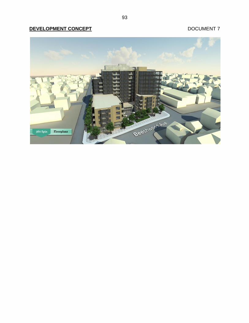
93
DEVELOPMENT CONCEPT DOCUMENT 7

94
VIEW TO PARLIAMENT HILL DOCUMENT 8