research analysis of the realistic evacuation behaviour ... · pdf fileresearch analysis of...
TRANSCRIPT

Research Analysis of The Realistic Evacuation Behaviour from Tsunami and Fire in the aftermath of The Great East Japan Earthquake 2011
YUKI AKIZUKI1, AKIHIKO HOKUGO2, and TOMOAKI NISHINO2
1: Faculty of Human Development, University of Toyama 3190 Gofuku, Toyama, Toyama 930-8555, JAPAN 2: Research Center for Urban Safety and Security, Kobe University 1-1 Rokkodai, Nada, Kobe 657-8501, JAPAN
ABSTRACT
On March 11, 2011, a devastating tsunami caused by the Great East Japan Earthquake hit many towns in Tohoku area, and a lot of residents had to evacuate from tsunami and ensuing fire. Collecting and comprehending their evacuation behavior is crucial to provide useful information for future major earthquakes.. In this report, some actual track maps of escape routes from tsunami and fire based on our interviews are shown, and the characteristic of the realistic evacuation behavior is extracted. Moreover the large-scale surveys conducted by other institutions are summarized to justify our consideration.
KEYWORDS: human behavior, human factors, egress, tsunami evacuation
INTRODUCTION
Evacuation studies from Tunami are being conducted in many fields s including civil engineering. Ootomo et al. conducted a questionnaire investigation about residents evacuation in areas expected to be hit by Nankai Tonankai Earthquake in the near future, with a view that previous simulation studies tend to oversimplify human behavior [1]. They collected 361 family unit data, and their findings show that “methods of information gathering is not established”, “evacuees want to carry their belongings“, and “evacuees want company like family members or neighbors, and avoid acting alone”. They indicate that evacuation system needs to reflect such human behavior characteristics.
On March 11, 2011, a devastating tsunami caused by the Great East Japan Earthquake hit many towns in Tohoku area, and a lot of residents had to evacuate from it and tsunami fire. Collecting and comprehending their evacuation behavior is crucial to provide useful information for future major earthquakes. Tsunami is not limited to Japan, as the Sumatra Earthquake in 2004 suggests, but can occur everywhere. It is likely that tsunami turns flooded houses into flammable rubbish, causing serious fires, as the Great East Japan Earthquake’s case. To minimize these damages in the near future, it is important to know exactly how affected people evacuated, and reflect their behavioral features on the disaster prevention plans and evacuation simulations.
In this report, firstly we show some actual track maps of escape routes from tsunami and fire from interviews we conducted in Yamada Town, Iwate Prefecture. Our survey because of difficulty in collecting data, has only limited number of interviewees, although the interviews were done thoroughly and in depth. Therefore we summarize large-scale surveys [2][3] conducted by other institutions to justify our consideration, too
TRAJECTORY SURVEY IN YAMADA TOWN, IWATE
Survey Overview
We conducted interviews in Yamada Town, Iwate Prefecture, where tsunami and ensuing fire caused serious damages, and evacuees took different patterns of evacuation choices. The town is comprised of intricate bays and mountainous areas. Among total population of 18634, 11418 lived in flooded area which is most of built-up zone. The maximum height of Tsunami around Yamada Town was about 8.5m at 15:26 (Fig.1) [4]. Tsunami claimed 604 deaths, 214 missing, and 3184 buildings collapsed. According to the survey of Japan Association for Fire Science and Engineering [5], the burned areas were 17.4ha of the
FIRE SAFETY SCIENCE-PROCEEDINGS OF THE ELEVENTH INTERNATIONAL SYMPOSIUM pp. 718-731 COPYRIGHT © 2014 INTERNATIONAL ASSOCIATION FOR FIRE SAFETY SCIENCE/ DOI: 10.3801/IAFSS.FSS.11-718
718

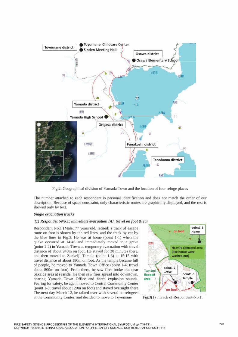
downtown, 0.24ha of the Osawa district, 396.4m2 of the Origasa district, and forest of the Tanohama district. Interview was conducted on June 4th and 5th in 2011, when the interviewees remembered things clearly, yet somehow recovered from mental shocks. They all lived in temporary refuge places in group. Many lost their houses because of tsunami, but those who did not lose houses (minority among our interviewees) also lived in refugees because there were plenty of supplies in refugee. Before interview we acquired admission of the managers of refuge places. Individual interviewees also were asked for permission for interview. It took 30-60 minutes per interviewee. We used residential maps of Yamada Town for their evacuation routes from the point they were at the time of earthquake to temporary refuge places. We also asked about how they evacuate (e.g. by car, or on foot) and with whom they moved. Interviewees are relocated to four refuge places (Yamada High School, Osawa Elementary School, Toyomane Childcare Center, and Shinden Meeting Hall). Many of Yamada Town’s residents are fishermen, living near the sea. Some of them evacuated to the refuge place near the sea. But there are some people who evacuated to mountain area for safety. Accordingly, we selected typical refuge places for interview.
Fig.2 shows the geographical division of Yamada Town and the location of the four refuge places. Yamada High School is the largest refuge place in Yamada Town and there are two gymnasiums, once accommodated about 1300 refugees from various parts of the town. At the time of survey, 333 people lived there. Refugees from Yamada district and Origasa district lived in the first gymnasium, those from Tanohama district and Funakoshi district lived the second gymnasium. In Osawa Elementary School, 90 refugees from Osawa district lived in four multi-purpose rooms. In Toyomane Childcare Center, 15 refugees from Yamada district lived. In Shinden Meeting Hall, 12 refugees from Yamada district lived.
Finally, we gather 9 cases of track of escape route from Yamada district, 7 from Osawa district and 1 from Tanohama district. As only three months passed since the earthquake, many of who were asked for interview were still unstable mentally and declined. As we wrote later, only one lost family member (wife) so the group may be not perfectly representative of whole population, but we thoroughly interviewed survivors’ behavior in detail and the results will be of great importance.
Fig.1: Tsunami Tidal Level at Miyako near Yamada Town on 11/03/2011 [4]
Following the track of escape routes
The results of 16 subjects’ escape routes are shown below. Out of 17 interviewees, one respondent was in one refuge place (Yamada Junior High School) at that time, so this case was excluded. We categorized escape patterns by single or group evacuation, and by three timing [A: immediate evacuation] that people started evacuation right after quake subsided, [B: evacuation after actions] that people did some actions after quake and before starting evacuation, and [C: imminent evacuation] that people started evacuation only after tsunami threat became imminent. The evacuation tools were categorized into three, on foot only, on foot and by car, and by car only.
FIRE SAFETY SCIENCE-PROCEEDINGS OF THE ELEVENTH INTERNATIONAL SYMPOSIUM pp. 718-731 COPYRIGHT © 2014 INTERNATIONAL ASSOCIATION FOR FIRE SAFETY SCIENCE/ DOI: 10.3801/IAFSS.FSS.11-718
719
point1 1Home
point1 2Grave
point1 3Temple
Tsunamifloodedarea
Heavily damaged area(like house werewashed out)
on foot
on foot
.
Toyomane Childcare Center
Osawa Elementary School
Yamada High School
Sinden Meeting HallOsawa district
Yamada district
Origasa district
Tanohama district
Funakoshi district
Toyomane district
Fig.2: Geographical division of Yamada Town and the location of four refuge places
The number attached to each respondent is personal identification and does not match the order of our description. Because of space constraint, only characteristic routes are graphically displayed, and the rest is showed only by text.
Single evacuation tracks
(1) Respondent-No.1: immediate evacuation [A], travel on foot & car
Respondent No.1 (Male, 77 years old, retired)’s track of escape route on foot is shown by the red lines, and the track by car by the blue lines in Fig.3. He was at home (point 1-1) when the quake occurred at 14:46 and immediately moved to a grave (point 1-2) in Yamada Town as temporary evacuation with travel distance of about 940m on foot. He stayed for 30 minutes there, and then moved to Zenkeiji Temple (point 1-3) at 15:15 with travel distance of about 180m on foot. As the temple became full of people, he moved to Yamada Town Office (point 1-4; travel about 800m on foot). From there, he saw fires broke out near Sakaida area at seaside. He then saw fires spread into downtown, nearing Yamada Town Office and heard explosion sounds. Fearing for safety, he again moved to Central Community Center (point 1-5; travel about 120m on foot) and stayed overnight there. The next day March 12, he talked over with several co-refugees at the Community Center, and decided to move to Toyomane Fig.3(1) : Track of Respondent-No.1.
FIRE SAFETY SCIENCE-PROCEEDINGS OF THE ELEVENTH INTERNATIONAL SYMPOSIUM pp. 718-731 COPYRIGHT © 2014 INTERNATIONAL ASSOCIATION FOR FIRE SAFETY SCIENCE/ DOI: 10.3801/IAFSS.FSS.11-718
720

in a mountain area. They started the move at 10:00 am, and reached to Shinden Meeting Hall (point 1-6; travel about 10.1km on foot and car) within the day. Since then up to the say of our survey, he has taken refuge there. He ended up travelling through 5 different refuge points traveling about 12 km during the two-day evacuation.
point1 1Homepoint1 2
Grave point1 3Temple
point1 4Town Office
point1 5CommunityCenter
point1 6SindenMeeting Hall
about 940m
Tsunamifloodedarea
Heavily damaged area (likehouse were washed out)
Firespreadarea
on footby car
Fig.3(2): Track of Escape Route of Respondent-No.1.
(2) Respondent-No.2: immediate evacuation [A], travel on foot & car
The track of escape route of Respondent No.2 (Female, 67 years old, retired) is shown in Fig.4. She was at home (point 2-1) when the quake occurred at 14:46. She left home immediately for Town Training Hall (point 2-2) and stayed there for 2 days. Then she moved to Toyomane Childcare Center (point 2-3) where her daughter worked.
point 2 1 Home
point 2 2Training Hall
Tsunamiflooded area
Heavilydamaged area
point 2 3ToyomaneChildcare Center
by car
on foot
on foot
Fig.4: Track of Escape Route of Respondent-No.2.
FIRE SAFETY SCIENCE-PROCEEDINGS OF THE ELEVENTH INTERNATIONAL SYMPOSIUM pp. 718-731 COPYRIGHT © 2014 INTERNATIONAL ASSOCIATION FOR FIRE SAFETY SCIENCE/ DOI: 10.3801/IAFSS.FSS.11-718
721

(3) Respondent-No.11: immediate evacuation [A], travel by car The track of escape route of Respondent No.11 (Male, 77 years old, retired) is as follows. He was at home at the time of earthquake, but immediately he moved to a factory located upper stream of Osawa River (630m), then in the early evening of the day, he moved with other evacuees by bus to Shinden Meeting Hall in Toyomane in the mountain area (6110m), and he settled there.
Group evacuation tracks with family
(4) Respondent-No.3: immediate evacuation [A], travel on foot
The track of Respondent No.3 (Male, 81 years old, farmer) is shown in Fig.5. He had worked on the field in the morning of the quake day. He got back home (point 3-1) to have lunch with his wife. They were at home when the quake occurred. They had prepared emergency bags, so they decided to move to Junior High School (point 3-2) immediately which was previously designated evacuation place. They walked along the JR Yamada line for 30 minutes (about 1440m). When they arrived there, they looked back to find many houses swept by tsunami. At night of later, they decided to move to Yamada High School (point 3-3) because of fear of fire spread to the Junior High School with other refugees (about 1050m on foot).
point 3 1Home
point 3 2Junior High School
Tsunamiflooded area
Heavily damaged area
point 3 3Yamada High School
on foot
point 5 1 Home
Tsunamiflooded area
Heavily damaged area by car
by car
point 5 2Junior High School
point 5 3Yamada High School
Fig.5: Track of Escape Route of Respondent-No.3. Fig.9: Track of Respondent-No.5.
(5) Respondent-No.9: immediate evacuation [A], travel on foot
Respondent No.9 (Male, 70 years old, retired fisherman)’s track of escape route is shown by the red lines in Fig.6. He was at home (point 9-1) alone when the quake started at 14:46. He predicted danger of being near sea, so moved to his sister’s house (point 9-2) located on the hill by traveling 150m on foot. He found out later that his evacuation bag only carried his clothes because he prepared evacuation very hastily. About 15:15, his wife could meet him and his sister at point 9-2 traveling about 960m on foot from point 9-3. The point 9-3 is in a higher and safer evacuation area, and is designated as a refuge place by the local government. Because he left virtually all their property, at 15:20, his wife chose to come back home to collect valuable things. But tsunami arrived and engulfed her, and she died. He and his sister immediately left his sister’s home to upper area by traveling 220m on foot, and they spent two nights at a stranger’s
FIRE SAFETY SCIENCE-PROCEEDINGS OF THE ELEVENTH INTERNATIONAL SYMPOSIUM pp. 718-731 COPYRIGHT © 2014 INTERNATIONAL ASSOCIATION FOR FIRE SAFETY SCIENCE/ DOI: 10.3801/IAFSS.FSS.11-718
722
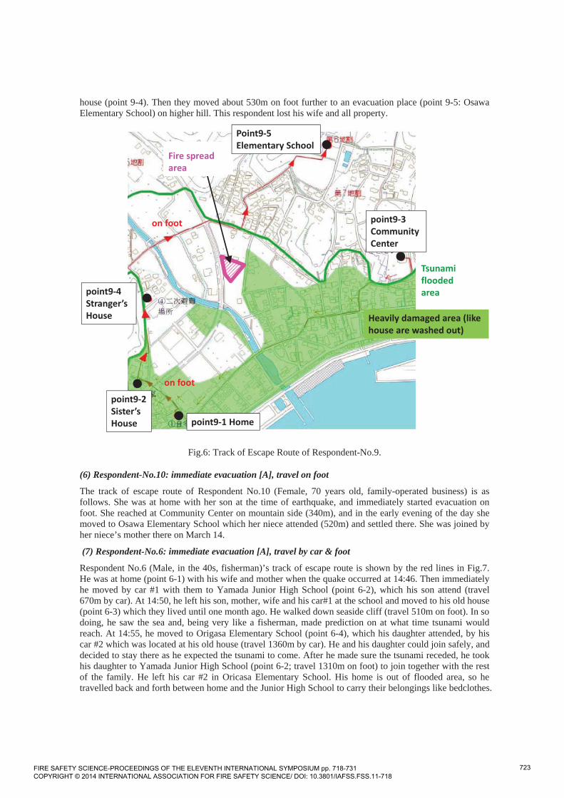
house (point 9-4). Then they moved about 530m on foot further to an evacuation place (point 9-5: Osawa Elementary School) on higher hill. This respondent lost his wife and all property.
point9 1 Home
point9 2Sister’sHouse
point9 3CommunityCenter
point9 4Stranger’sHouse
Point9 5Elementary School
Tsunamifloodedarea
Heavily damaged area (likehouse are washed out)
Fire spreadarea
on foot
on foot
Fig.6: Track of Escape Route of Respondent-No.9.
(6) Respondent-No.10: immediate evacuation [A], travel on foot
The track of escape route of Respondent No.10 (Female, 70 years old, family-operated business) is as follows. She was at home with her son at the time of earthquake, and immediately started evacuation on foot. She reached at Community Center on mountain side (340m), and in the early evening of the day she moved to Osawa Elementary School which her niece attended (520m) and settled there. She was joined by her niece’s mother there on March 14.
(7) Respondent-No.6: immediate evacuation [A], travel by car & foot
Respondent No.6 (Male, in the 40s, fisherman)’s track of escape route is shown by the red lines in Fig.7. He was at home (point 6-1) with his wife and mother when the quake occurred at 14:46. Then immediately he moved by car #1 with them to Yamada Junior High School (point 6-2), which his son attend (travel 670m by car). At 14:50, he left his son, mother, wife and his car#1 at the school and moved to his old house (point 6-3) which they lived until one month ago. He walked down seaside cliff (travel 510m on foot). In so doing, he saw the sea and, being very like a fisherman, made prediction on at what time tsunami would reach. At 14:55, he moved to Origasa Elementary School (point 6-4), which his daughter attended, by his car #2 which was located at his old house (travel 1360m by car). He and his daughter could join safely, and decided to stay there as he expected the tsunami to come. After he made sure the tsunami receded, he took his daughter to Yamada Junior High School (point 6-2; travel 1310m on foot) to join together with the rest of the family. He left his car #2 in Oricasa Elementary School. His home is out of flooded area, so he travelled back and forth between home and the Junior High School to carry their belongings like bedclothes.
FIRE SAFETY SCIENCE-PROCEEDINGS OF THE ELEVENTH INTERNATIONAL SYMPOSIUM pp. 718-731 COPYRIGHT © 2014 INTERNATIONAL ASSOCIATION FOR FIRE SAFETY SCIENCE/ DOI: 10.3801/IAFSS.FSS.11-718
723

point6 1 Home
point6 2Junior HighSchool
point6 3Old House
point6 4ElementarySchool
point6 5High School
Tsunami flooded area
Heavily damaged area
by car
on foot
on foot
by car
Fig.7: Track of Escape Route of Respondent-No.6.
At night of March 11, he decided to move to Yamada High School (point 6-5) because of fear of fire spread to the Junior High School with other refugees.
(8) Respondent-No.13: immediate evacuation [A], travel by car & foot
The track of escape route of Respondent No.13 (Female, 56 years old, fisherwoman) is shown in Fig.8. At the time of earthquake she was her workplace (point13-1) 210m apart from home with her husband. She immediately got back home by car (point13-2) and carried a bag with valuables and took her mother (age 93) and started evacuation. She stopped by the house of husband’s sister (point13-3, 770m) and husband went to house of his friend with bad feet (point13-4, 50m) when tsunami came, so she alone escaped to a temple nearby (point13-5). Later she walked 590m to Osawa Elementary School (point13-6). Her husband took his friend to sister’s house, and came up to second floor because of tsunami. Water came near, so he put his friend and mother into closet and he and sister hanged on a pillar and waited for rescue. The rescue saved them and they moved to Community Center (point13-7), spent a night there, assuming his wife (she) was killed by tsunami. On March 12, husband and others went to Osawa Elementary School and were joined by his wife. They settled there.
(9) Respondent-No.4: immediate evacuation [A], travel by car
The track of escape route of Respondent No.4 (Female, 53 years old, company worker) is as follows. She was at her company office in neighboring Miyako City at the time of earthquake, and immediately moved by car (about 20km) to a nursery where her grandson was. She joined with daughter and grandson, and moved to higher place (770m) in order to take a look at tsunami. She moved by car to a temple (see Figure 3, point1-3), but she felt danger as fire got closer, and went back to higher place and spent a night in the car there. They moved to an elder care facility to find the place full of refugees, so moved on to Toyomane Elementary School by car. They stayed for 5 days, and then moved to Toyomane Nursery and settled there. For 5 days she moved 32690m among seven different refuge places.
FIRE SAFETY SCIENCE-PROCEEDINGS OF THE ELEVENTH INTERNATIONAL SYMPOSIUM pp. 718-731 COPYRIGHT © 2014 INTERNATIONAL ASSOCIATION FOR FIRE SAFETY SCIENCE/ DOI: 10.3801/IAFSS.FSS.11-718
724

point 13 1Office
point 13 2Home
point 13 3Sister’s house
point 13 4Friend’s house
point 13 6CommunityCenter
point 13 5Temple
point 13 7Elementary School
Heavilydamagedarea
Tsunamifloodedarea
on foot
on foot
by car
Fig.8: Track of Respondent-No.13.
(10) Respondent-No.5: immediate evacuation [A], travel by car
The track of escape route of Respondent (Female, No.5, house wife in 40's) is shown in Fig.9. She was at home with family members when the quake occurred, so she quickly drove a car to Junior High School (point 5-2), previously designated evacuation place. When driving, she felt the tremor but the road was not jammed. At night of later, they decided to move to Yamada High School (point 5-3) by car because of fear of fire spread to the Junior High School.
(11) Respondent-No.12: immediate evacuation [A], travel by car
The track of escape route of Respondent No.12 (Female in 60’s) is as follows. She was at home with her daughter and mother-in-law at the time of earthquake, and immediately moved to higher place 540m away by car. Then she moved to Osawa Elementary School (1020m). Her husband was in Miyako City at that time, and they joined 16:00 of the day, the four settled there.
(12) Respondent-No.16: evacuation after actions [B], travel on foot
The track of escape route of Respondent No.16 (Female, 70 years old, house wife) is as follows. She was at home with her husband at the time of earthquake. Husband (fisherman) went out to take care of his boat, and she started evacuation after she checked out fire and keys. Her neighborhood was on fire, so she escaped to a temple on a mountain side with about 120 neighbors. Then she moved to a hotel on the mountain top and spent a night there. On March 12 the two joined at the hotel but because of fire nearby, they evacuated by helicopter to Yamada Senior High School and settled there.
(13) Respondent-No.7: evacuation after actions [B], travel on foot and car
The track of escape route of Respondent No.7 (Female, 20 years old, student) is shown in Fig.10.
FIRE SAFETY SCIENCE-PROCEEDINGS OF THE ELEVENTH INTERNATIONAL SYMPOSIUM pp. 718-731 COPYRIGHT © 2014 INTERNATIONAL ASSOCIATION FOR FIRE SAFETY SCIENCE/ DOI: 10.3801/IAFSS.FSS.11-718
725

She was at home (point7-1) with his grandfather and grandmother when the quake occurred at 14:46. They heard emergency warning. Her mother was working nearby (point 7-2), and came back home 5 minutes later (120m on foot). They assumed that tsunami would reach as high as 1st floor, so they together moved furniture and household goods to 2nd floor for 10 minutes. Around 15:05, they left home, and arrived at Community Center (point 7-3) on foot around 15:15. Later, they saw fire near the Community Center so went to Sinden Meeting Hall (point 7-4) by a relative's car.
point 7 1 Home
point 7 3CommunityCenter
point 7 2Mother’s office
Tsunamiflooded area
Heavilydamagedarea
Fire spreadarea
point 7 4SindenMeeting Hall
by car
on foot
Fig.10: Track of Escape Route of Respondent-No.7. (14) Respondent-No.14: evacuation after actions, travel by car
The track of escape route of Respondent No.14 (Female, unknown age, retired) is shown in Fig.11. She was at home (point 14-1) with two sons when the quake occurred. She anticipated tsunami would come, so they prepared evacuation for 15minutes and left home. She drove a car to Junior High School (point 14-2) without traffic jam. Instead of the nearest evacuation place, she chose point 14-2, which required longer and probably more dangerous routes near the sea, because she thought they had to evacuate to higher place, based on her hunch. She did not take Yamada Road (branch road of National Route 45 which she drove) on the mountain, because she feared, based on the memory of the Great Hanshin Earthquake, that bridge supports could have been broken. She saw the tsunami subsided while driving. Later, they decided to move to Yamada High School (point 14-3) by car because of fear of fire spread to the Junior High School with other refugees about 1050m by car).
Fig.11: Track of Escape Route of Respondent-No.14.
point 14 1 HomeTsunamiflooded area
Heavilydamagedarea
by car
by car
point 14 2Junior High School
point 14 3Yamada High School
FIRE SAFETY SCIENCE-PROCEEDINGS OF THE ELEVENTH INTERNATIONAL SYMPOSIUM pp. 718-731 COPYRIGHT © 2014 INTERNATIONAL ASSOCIATION FOR FIRE SAFETY SCIENCE/ DOI: 10.3801/IAFSS.FSS.11-718
726

(15) Respondent-No.15: evacuation after actions [B], travel by car
The track of escape route of Respondent No.15 (Female, 65 years old, house wife) is shown in Fig.12. She was at home (point 15-1) with a grand child when the quake occurred at 14:46. Anticipating the danger, she started to prepare evacuation while waiting for her son to come back. The son came back from Osawa Scallop Center (point 15-2) where he worked around 14:50. They started evacuation by car around 14:55. At first, they thought that they would go to parents' home (point 15-3) by Osawa River, 1 km away from their home. But they decided not to go there because of fear of tsunami, and instead, to go to Osawa Elementary School (point 15-4).
point 15 1Home
Tsunamiflooded area
Heavily damaged area
by car
by car
point 15 2Son’s Office
point 15 3Parent’s Homenot going
on foot
point 15 4 Elementary School
Fig.12: Track of Escape Route of Respondent-No.15.
(16) Respondent-No.8: evacuation after actions [B], travel by car
The track of escape route of Respondent No.8 (Male in 50’s, family-operated business) is as follows. He (barber) was taking care of three customers at the time of earthquake, but he immediately closed the shop and started preparation for evacuation. With his wife, son and son’s wife, a grandchild, he drove his car. He chose a back road (the same route with Respondent-No.3) to avoid congestion, and reached to Yamada Junior High School (20minutes, 1160m). As fire came near, they moved to Yamada Senior High School and settled there.
Overview of Evacuation Actions
Based on previous research results, besides the start point of evacuation and the last refuge place, five more items should be included in describing the evacuation movements; (1) timing of evacuation ([A: immediate evacuation], [B: evacuation after actions] and [C: imminent evacuation]), (2) evacuation tool (on foot, by car, foot & car), (3) evacuation company (single evacuation, group evacuation such as family), (4) required time taking right before evacuation, and (5) distance from the start point to the primary evacuation point which includes the movement distance for picking up family members.
The results are shown in Table 1. Value in Column (3) of the table changes, which means that between the start point and the last point of evacuation, the number of the evacuating group increases or decreases as they meet or separate along the way. Column (4) is the time of starting evacuation, which is applicable to whose evacuation timing is [B] or [C] only, and “Unknown” in column (4) means when the respondents could not recall the timing. Column (6) is total distance of evacuation actions, including movement to pick up family members. Table 1 indicates that our respondents show higher, as there many [A] and no [C]. They tend to evacuate together with family members except single households. The evacuation cases by car is slightly more superior than the evacuation cases on foot.
FIRE SAFETY SCIENCE-PROCEEDINGS OF THE ELEVENTH INTERNATIONAL SYMPOSIUM pp. 718-731 COPYRIGHT © 2014 INTERNATIONAL ASSOCIATION FOR FIRE SAFETY SCIENCE/ DOI: 10.3801/IAFSS.FSS.11-718
727
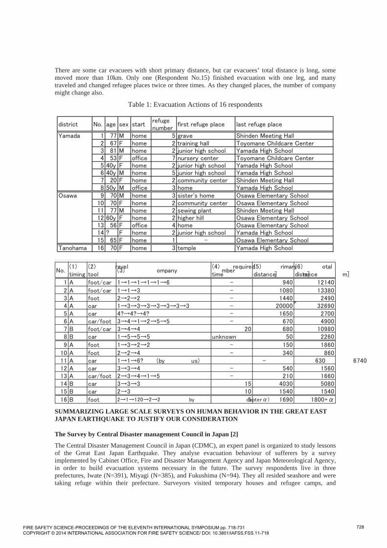
There are some car evacuees with short primary distance, but car evacuees’ total distance is long, some moved more than 10km. Only one (Respondent No.15) finished evacuation with one leg, and many traveled and changed refugee places twice or three times. As they changed places, the number of company might change also.
Table 1: Evacuation Actions of 16 respondents
SUMMARIZING LARGE SCALE SURVEYS ON HUMAN BEHAVIOR IN THE GREAT EAST JAPAN EARTHQUAKE TO JUSTIFY OUR CONSIDERATION
The Survey by Central Disaster management Council in Japan [2]
The Central Disaster Management Council in Japan (CDMC), an expert panel is organized to study lessons of the Great East Japan Earthquake. They analyse evacuation behaviour of sufferers by a survey implemented by Cabinet Office, Fire and Disaster Management Agency and Japan Meteorological Agency, in order to build evacuation systems necessary in the future. The survey respondents live in three prefectures, Iwate (N=391), Miyagi (N=385), and Fukushima (N=94). They all resided seashore and were taking refuge within their prefecture. Surveyors visited temporary houses and refugee camps, and
FIRE SAFETY SCIENCE-PROCEEDINGS OF THE ELEVENTH INTERNATIONAL SYMPOSIUM pp. 718-731 COPYRIGHT © 2014 INTERNATIONAL ASSOCIATION FOR FIRE SAFETY SCIENCE/ DOI: 10.3801/IAFSS.FSS.11-718
728

exchanged questions and answers face to face, with respondents who had agreed to cooperate. Interview period is from 1st to 31st in July 2011. Each interview took 30-60 minutes.
Fig.13 shows the evacuation behaviour in the aftermath of the Great East japan Earthquake. Fifty-seven percentage of the all respondents started evacuation right after quake subsided [A: immediate evacuation],. Thirty-one percentage of the all respondents did some actions after quake and before starting evacuation [B: evacuation after actions], and 11 percentage of the all respondents started evacuation only after tsunami threat became imminent [C: imminent evacuation]..These traits are seen equally in all three prefectures. Our respondents show higher awareness of crisis than this CDMC results, as there many [A] and no [C].
Fig.13: Evacuation Behaviour in the Aftermath of Earthquake [2].
The respondents who took some actions by [B] and [C] were asked further what kind of action they took (multiple answers allowed) [2]. Totally 361 answers were collected, and the results shows in Fig.14. Top three answers were “coming back to home (22%)” “looking for family members or picking them up (21%)” and “checking if family members are safe (13%)”, which are corresponding with Ootomo et al’s findings[1] and our results.
Fig.14: Behaviour in the Aftermath of Earthquake [B]+[C] (partly modified from CDMC data)
Fifty-seven percentage (N=485) of all the respondents used cars for evacuation [2]. Top 6 reasons to use cars were not only “because it was chosen as a fast transportation tool” (No.1, 167 respondents), but also “because it allows our family to evacuate together” (No.2, 154 respondents), “they were riding their cars on a daily basis (No.3, 110 respondents)”, “because the safer refuge area was seemed too far away to reach without car “(No.4, 96 respondents)”, “because I was driving the car when I started evacuation (No.5, 92 respondents), and “because I need to pick up family members”(No.6, 77 respondents). It shows that they use cars not only as fast transportation, but also coming from the fact that they drive a car on daily basis. Heavy dependency on automobile in rural society in Japan therefore resulted in the situation that one third of all evacuees “were stuck in traffic jam [2].” Also, many responded that they had no choice but to drive the car to evacuate with family including seniors and people with disabilities, indicating that “upland relocation policy” meaning relocate people to higher places in order to avoid damage of tsunami requires viewpoints of seniors and those in need for care. Some though not many responded that they used cars because “the car itself is precious property”, or “the car can carry many belongings”., suggesting some make decisions based on protecting property, not immediate escape. Our results shows the similar tendency.
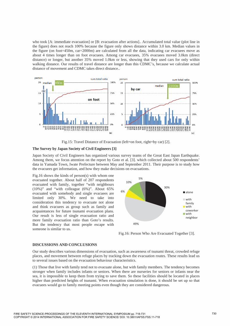
In CDMC report, the travel distance of evacuation was defined as linear distance on a plane field between place where respondents are when earthquake occurred and place of primary evacuation [2]. Fig.15 is frequency distribution divided by on foot evacuees (218 respondents) and car evacuees (327 respondents)
FIRE SAFETY SCIENCE-PROCEEDINGS OF THE ELEVENTH INTERNATIONAL SYMPOSIUM pp. 718-731 COPYRIGHT © 2014 INTERNATIONAL ASSOCIATION FOR FIRE SAFETY SCIENCE/ DOI: 10.3801/IAFSS.FSS.11-718
729
30%
49%
6%
10%5%
alone
withfamilywithcoworkerwithneighbor
who took [A: immediate evacuation] or [B: evacuation after actions].. Accumulated total value (plot line in the figure) does not reach 100% because the figure only shows distance within 3.0 km. Median values in the figure (on foot=450m, car=2000m) are calculated from all the data, indicating car evacuees move as about 4 times longer than on foot evacuees. Among car evacuees, 35% evacuees moved 3.0km (direct distance) or longer, but another 35% moved 1.0km or less, showing that they used cars for only within walking distance. Our results of travel distance are longer than this CDMC’s, because we calculate actual distance of movement and CDMC takes direct distance..
Fig.15: Travel Distance of Evacuation (left=on foot, right=by car) [2].
The Survey by Japan Society of Civil Engineers [3]
Japan Society of Civil Engineers has organized various survey teams of the Great East Japan Earthquake. Among them, we focus attention on the report by Goto et al. [3]. which collected about 500 respondents’ data in Yamada Town, Iwate Prefecture between May and September 2011. Their purpose is to study how the evacuees get information, and how they make decisions on evacuations.
Fig.16 shows the kinds of person(s) with whom one evacuated together. About half of 207 respondents evacuated with family, together “with neighbours (10%)” and “with colleague (6%)”. About 65% evacuated with somebody and single evacuees are limited only 30%. We need to take into consideration this tendency to evacuate not alone and think evacuees as group such as family and acquaintances for future tsunami evacuation plans. Our result is less of single evacuation ratio and more family evacuation ratio than Goto’s results. But the tendency that most people escape with someone is similar to us.
Fig.16: Person Who Are Evacuated Together [3].
DISCUSSIONS AND CONCLUSIONS
Our study describes various dimensions of evacuation, such as awareness of tsunami threat, crowded refuge places, and movement between refuge places by tracking down the evacuation routes. These results lead us to several issues based on the evacuation behaviour characteristics.
(1) Those that live with family tend not to evacuate alone, but with family members. The tendency becomes stronger when family includes infants or seniors. When there are nurseries for seniors or infants near the sea, it is impossible to keep them from trying to save them. So these facilities should be located in places higher than predicted heights of tsunami. When evacuation simulation is done, it should be set up so that evacuees would go to family meeting points even though they are considered dangerous.
FIRE SAFETY SCIENCE-PROCEEDINGS OF THE ELEVENTH INTERNATIONAL SYMPOSIUM pp. 718-731 COPYRIGHT © 2014 INTERNATIONAL ASSOCIATION FOR FIRE SAFETY SCIENCE/ DOI: 10.3801/IAFSS.FSS.11-718
730

(2) When family members meet the point which family members had agreed in advance, the points are various, like : home, : nearby refuge place the local government designate, and : refuge place the local government designate and family member commute (school or child care center). In case of or , they moved longer distance for picking up family members at several points. Our results show that many tend to pick up family members who needed care (like seniors in care facility, children in school) resulting in longer distance of movement, too.
(3) It tends to be that half of evacuees use car despite the possibility of congestion. When an evacuation simulation in rural area is done, it should be set up that half would drive a car. In evacuation planning, car evacuation cannot be completely ruled out, because car is useful to carry family and properties. But let us remind that all interviewees are survivors, and some of them discarded car, or just narrowly passed through tsunami. Car evacuation is not proven safe at all.
(4) Too many refugees make refugee places useless. After careful prediction on how many people would come, it is necessary to plan where extra refugees can move next.
(5) There is no respondent who could get effective information while they were evacuating. So it is all the more important to train and decide which route in advance for quick evacuation. It is necessary to manage the handling of valuables for immediate evacuation. In evacuation simulation, it should not give community leader too much effectiveness in leading the evacuation group (the effectiveness is not to be expected).
ACKNOWLEDGEMENTS
We would like to express our gratitude and appreciation for all who cooperated in this research, and Mr Kazuya Wakabayashi, a student at Kobe University who helped our research.
REFERENCES
[1] Otomo, R., Murosaki, Y., and Hokugo, A., “A Study on Evacuation System based on the Human Behavioral Characteristics at Tsunami”, Synopses of Institute of Social Safety Science 14:Institute of Social Safety Science, 2004, pp.77-80, (published in Japanese).
[2] Central Disaster Management Council in Japan “Report of the Committee for Technical Investigation on Countermeasures for Earthquakes and Tsunamis based on the Lessons Learned from the “2011 the Pacific coast of Tohoku Earthquake””, 2011, 1-6-1 Nagata-cho, Chiyoda-ku, Tokyo 100-8914, Japan, 91p. (published in Japanese).
[3] Yozo Goto, “Fact-Finding about Evacuation from the Unexpectedly Large Tsunami, Task team on Yamada-machi and Ishinomaki-shi, Tsunami Evacuation Survey Group of the Great East Japan Earthquake Disaster”, Proceedings of the International Symposium on Engineering Lessons Learned from the 2011 Great East Japan Earthquake, Architectural Institute of Japan, 2012, pp.1617-1628.
[4] The Japan Meteorological Agency, “Technical Report on the 2011 Off The Pacific Coast of Tohoku Earthquake, No.133”, 2012, 1-3-4 Otemachi, Chiyoda-ku, Tokyo 100-8122, Japan, pp.89-119. (published in Japanese).
[5] Japan Association for Fire Science and Engineering, “Flash report on the investigation on the Great East Japan Earthquake”, 2011, 2-4-16, Yayoi, Bunkyo-ku, Tokyo 113-0032, Japan, 1029p. (published in Japanese).
FIRE SAFETY SCIENCE-PROCEEDINGS OF THE ELEVENTH INTERNATIONAL SYMPOSIUM pp. 718-731 COPYRIGHT © 2014 INTERNATIONAL ASSOCIATION FOR FIRE SAFETY SCIENCE/ DOI: 10.3801/IAFSS.FSS.11-718
731