research equipment for irrigation management - eijkelkamp
TRANSCRIPT

All it takes for environmental research
Research equipment for
Irrigation managementEijkelkamp Agrisearch Equipment
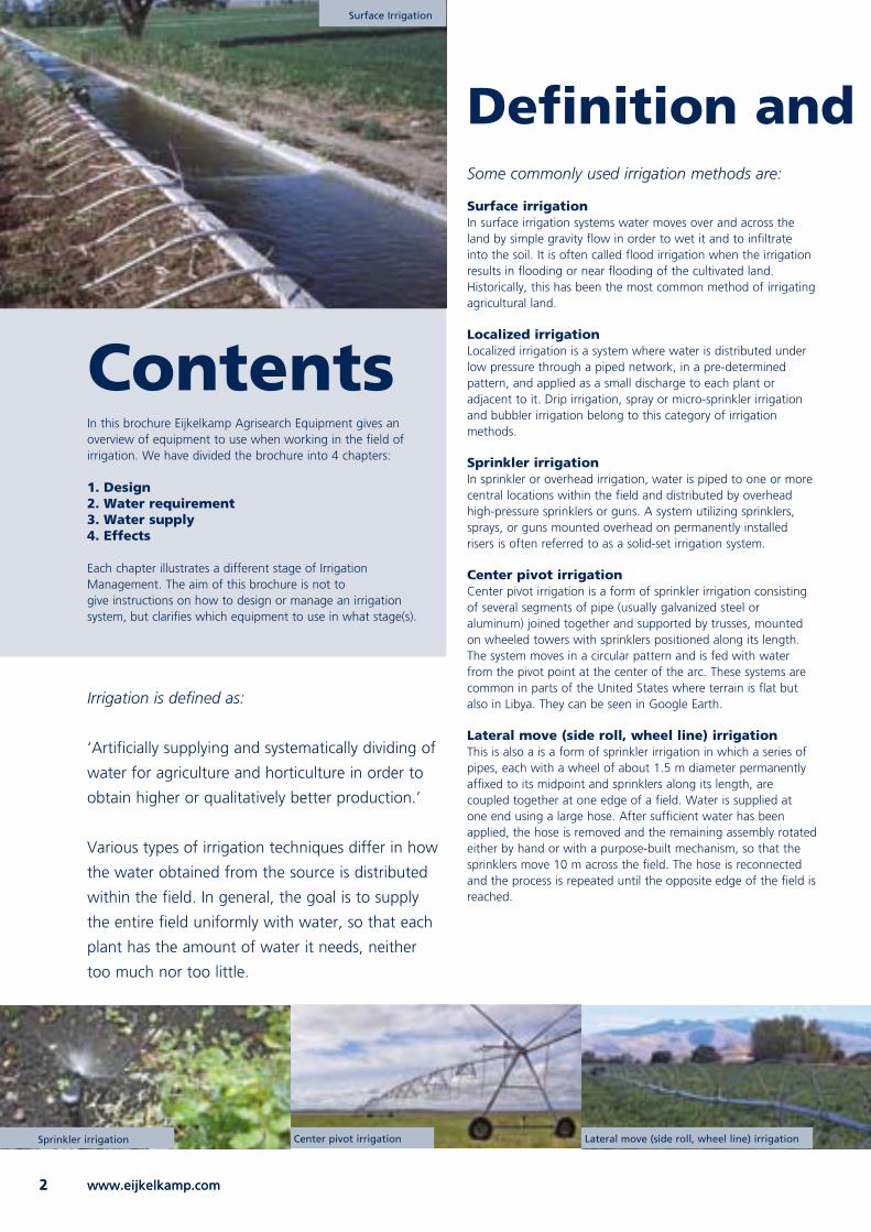
Surface Irrigation
www.eijkelkamp.com2 www.eijkelkamp.com2
Irrigation is defined as:
‘Artificially supplying and systematically dividing of
water for agriculture and horticulture in order to
obtain higher or qualitatively better production.’
Various types of irrigation techniques differ in how
the water obtained from the source is distributed
within the field. In general, the goal is to supply
the entire field uniformly with water, so that each
plant has the amount of water it needs, neither
too much nor too little.
ContentsIn this brochure Eijkelkamp Agrisearch Equipment gives an overview of equipment to use when working in the field of irrigation. We have divided the brochure into 4 chapters:
1. Design2. Water requirement3. Water supply4. Effects
Each chapter illustrates a different stage of Irrigation Management. The aim of this brochure is not togive instructions on how to design or manage an irrigation system, but clarifies which equipment to use in what stage(s).
Definition and irrigation methodsSome commonly used irrigation methods are:
Surface irrigationIn surface irrigation systems water moves over and across the land by simple gravity flow in order to wet it and to infiltrate into the soil. It is often called flood irrigation when the irrigation results in flooding or near flooding of the cultivated land. Historically, this has been the most common method of irrigating agricultural land.
Localized irrigationLocalized irrigation is a system where water is distributed under low pressure through a piped network, in a pre-determined pattern, and applied as a small discharge to each plant or adjacent to it. Drip irrigation, spray or micro-sprinkler irrigation and bubbler irrigation belong to this category of irrigation methods.
Sprinkler irrigationIn sprinkler or overhead irrigation, water is piped to one or more central locations within the field and distributed by overhead high-pressure sprinklers or guns. A system utilizing sprinklers, sprays, or guns mounted overhead on permanently installed risers is often referred to as a solid-set irrigation system.
Center pivot irrigationCenter pivot irrigation is a form of sprinkler irrigation consisting of several segments of pipe (usually galvanized steel or aluminum) joined together and supported by trusses, mounted on wheeled towers with sprinklers positioned along its length. The system moves in a circular pattern and is fed with water from the pivot point at the center of the arc. These systems are common in parts of the United States where terrain is flat but also in Libya. They can be seen in Google Earth.
Lateral move (side roll, wheel line) irrigationThis is also a is a form of sprinkler irrigation in which a series of pipes, each with a wheel of about 1.5 m diameter permanently affixed to its midpoint and sprinklers along its length, are coupled together at one edge of a field. Water is supplied at one end using a large hose. After sufficient water has been applied, the hose is removed and the remaining assembly rotated either by hand or with a purpose-built mechanism, so that the sprinklers move 10 m across the field. The hose is reconnected and the process is repeated until the opposite edge of the field is reached.
Surface Irrigation
Sprinkler irrigation Center pivot irrigation Lateral move (side roll, wheel line) irrigation
3All it takes for environmental researchAll it takes for environmental research 3
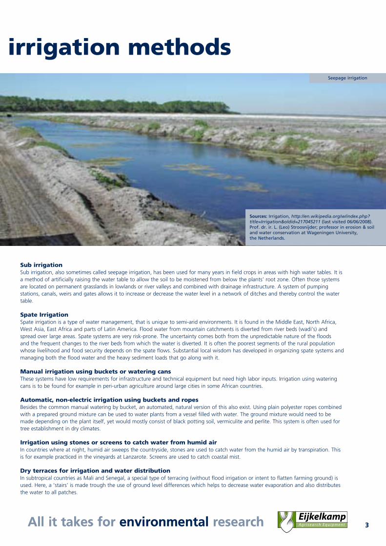
Sub irrigationSub irrigation, also sometimes called seepage irrigation, has been used for many years in field crops in areas with high water tables. It is a method of artificially raising the water table to allow the soil to be moistened from below the plants’ root zone. Often those systems are located on permanent grasslands in lowlands or river valleys and combined with drainage infrastructure. A system of pumping stations, canals, weirs and gates allows it to increase or decrease the water level in a network of ditches and thereby control the water table.
Spate IrrigationSpate irrigation is a type of water management, that is unique to semi-arid environments. It is found in the Middle East, North Africa, West Asia, East Africa and parts of Latin America. Flood water from mountain catchments is diverted from river beds (wadi’s) and spread over large areas. Spate systems are very risk-prone. The uncertainty comes both from the unpredictable nature of the floods and the frequent changes to the river beds from which the water is diverted. It is often the poorest segments of the rural population whose livelihood and food security depends on the spate flows. Substantial local wisdom has developed in organizing spate systems and managing both the flood water and the heavy sediment loads that go along with it.
Manual irrigation using buckets or watering cansThese systems have low requirements for infrastructure and technical equipment but need high labor inputs. Irrigation using watering cans is to be found for example in peri-urban agriculture around large cities in some African countries.
Automatic, non-electric irrigation using buckets and ropesBesides the common manual watering by bucket, an automated, natural version of this also exist. Using plain polyester ropes combined with a prepared ground mixture can be used to water plants from a vessel filled with water. The ground mixture would need to be made depending on the plant itself, yet would mostly consist of black potting soil, vermiculite and perlite. This system is often used for tree establishment in dry climates.
Irrigation using stones or screens to catch water from humid airIn countries where at night, humid air sweeps the countryside, stones are used to catch water from the humid air by transpiration. This is for example practiced in the vineyards at Lanzarote. Screens are used to catch coastal mist.
Dry terraces for irrigation and water distributionIn subtropical countries as Mali and Senegal, a special type of terracing (without flood irrigation or intent to flatten farming ground) is used. Here, a ‘stairs’ is made trough the use of ground level differences which helps to decrease water evaporation and also distributes the water to all patches.
Definition and irrigation methods
Sources: Irrigation, http://en.wikipedia.org/w/index.php? title=Irrigation&oldid=217045211 (last visited 06/06/2008). Prof. dr. ir. L. (Leo) Stroosnijder; professor in erosion & soil and water conservation at Wageningen University, the Netherlands.
Seepage irrigation

www.eijkelkamp.comwww.eijkelkamp.com4
The first step of irrigation management after
determining the type of irrigation you are
going to use, is to design an irrigation system.
The aim of the irrigation and the type of crop
you are growing of course are important
factors in this stage.
When the type of irrigation is determined and
the system is designed, you will need to survey
the land and prepare it for irrigation.
1.Design
Soil profile 01.11.SO Auger set for heterogeneous soilsAugerings and samplings in homogeneous soils (soils with a uniform soil profile), in almost all cases can be executed with one type of auger. For augerings in heterogeneous soils (soils with a layered soil profile), several different auger types will be applied. This led to the composition of an auger set for heterogeneous soils. With the standard set it is possible to execute manual augering to a depth of 5 metres, without great physical effort. The set can be used for augerings above the water table in all soils, and below the water table in cohesive soils.
08.04 Sand rulers A sand ruler is a disc made of transparent material with standard (specimen) samples. It is an excellent indicative aid in determining the particle size distribution. Of the sample to be tested a representative part is rubbed dry with the fingers in the palm of the hand. The sample is then placed in the hollow area in the centre of the ruler. The average grain size is now judged by comparing the average grain size of the sample with the specimen in the ruler. The sand ruler is available with different fractions.
08.11 Soil colour chartsDetermination of a subgroup in the soil classification system is based among other aspects on colour differences. The colour of the soil is determined by comparing the sample with standard soil colour charts (Munsell). Soil colour charts are available in a Japanese (12 colour charts) and American (8 colour charts) version.

All it takes for environmental research 5All it takes for environmental research
08.05 Granular composition test setThe particle size distribution (also called grain size distribution or texture) is one of the most important characteristics of the soil. The particle size distribution has an effect on many properties of the soil, such as the ease of tillage, the capillary conductivity of a soil, the available moisture, the permeability of a soil, compaction, etc. Applying the granular composition test set allows you to determine the particle size distribution of soil samples in order to be able to classify the soils on the basis of international standards.
08.16 Pipette apparatusA simple method for the determination of the particle size is the pipette method. After carbonates, organic substances and possible iron oxide have been removed (because of their binding function) the pipette method is used to determine the fractions of particles smaller than 38 µm. The pipette apparatus is available as a table model and as a wall model.
08.30 Hydrometer kit, standard setTo obtain an accurate determination of the particle size distribution of the smallest fractions it is possible to apply the hydrometer method. In this method the sample is cleaned from organic matter after which it is dried and weighed. Next it is suspended in water and sieved. The solution that passes through the sieve is transferred to a measuring cylinder with water. Hydrometer readings are taken after regular intervals. Sedimentation time and hydrometer readings are used to determine the grain sizes according to the Stoke’s law.
Soil structure 08.13 Wet sieving apparatusThe aggregate stability of a soil is the resistance of soil structure against mechanical or physico-chemical destructive forces. Soil structure is one of the main factors controlling plant growth by its influence onroot penetration, soil temperature and gas diffusion, water transport and seedling emergence. The wet sieving apparatus is used to determine the above mentioned aggregate stability.
Soil texture

www.eijkelkamp.com6 www.eijkelkamp.com
09.04 Double ring infiltrometer (for use in the field)The double ring infiltrometer may be used for determining the rate of infiltration and capacity for irrigation and drainage projects, studying drainage, determining the intensity of artificial precipitation and the effect of treatment of the soil. The rate of infiltration is determined as the amount of water per surface area and time unit, which penetrates the soil. This rate can be calculated on the basis of measuring results and the Law of Darcy.
09.11 Ksat constant head permeameter (for use in bore holes)The Ksat constant head permeameter is an instrument that provides the means to collect data for determining in situ saturated hydraulic conductivity of the vadose (unsaturated) zone easily and conveniently. The measuring procedure is known as constant head well permeameter technique, shallow well pump-in method or borehole infiltration test.
09.09 Tension infiltrometerThe tension infiltrometer measures the hydraulic properties of unsaturated soil. Water held under tension infiltrates into a dry soil through a highly permeable nylon membrane. The time dependent infiltration rate is used to calculate unsaturated hydraulic conductivities and related hydraulic properties. Infiltration rates are recorded manually.
09.02 Soil water permeameter (for laboratory use)The planning and execution of hydrological and soil technical projects (for instance drainage and irrigation) is almost always preceded by geo-hydrologic research. The water and air permeability of the soil to a large extend determines how efficient an irrigation or drainage system functions. Determining the saturated water permeability (horizontal as well as vertical) can be executed in the laboratory with a soil water permeameter.
07.53.SC/SE Sample ring kits (for laboratory use)These sample sets, from which one is suitable for very hard soils, can be used to take samples in sample rings in virtually all soils. The samples can be taken on the surface, in auger holes or in profile pits, above as well as under the groundwater level in cohesive soils. The closed ring holder in this set is fitted with a conical threaded connection which means that the ring holder may also be hammered into the soil with an impact absorbing hammer.
Hydraulic conductivity
Soil’s water holding capacity
08.01/02/03 Instruments for pF-determinationThe determination of the moisture characteristics (pF-curve) is essential when researching the quantity of water available in the soil for plants and trees. Depending on the desired measuring range underpressure (the so called sandboxes) or overpressure (membrane apparatus) is used.
08.25 Ceramic plates for pF-determination Determination of soil moisturecharacteristics can be done by manymethods. One of them is the methodof determination of pF-curves (pF upto 4.2) with ceramic plates. This is arelatively simple method and a reliableway of removing soil moisture, undercontrolled conditions, from soilsamples without disturbing the soilstructure. The method is usually appliedon prepared samples.

7All it takes for environmental researchAll it takes for environmental research
Groundwater monitoring pipesMonitoring well pipes are used to compose monitoring wells and piezometers. Monitoring well pipes are available in different materials and diameters.
11.03 Sounding deviceThe sounding apparatus, with acoustic and light signal, is used to determine liquid levels in boreholes, monitoring well pipes, etc. When the probe, which is connected to a measuring tape with centimetre graduation, touches a conductive liquid, a clear acoustic and light signal is produced. If the cable is then lifted a little, the signal will stop. Determination of this point allows the user to read the depth directly form the measuring tape.
11.11 Diver The Diver from Schlumberger Water Services is the smallest instrument in the world for automatic measurement and continuous registration of groundwater levels and groundwater temperatures. The Diver fits in the palm of your hand, is remarkably light and can be used in virtually any monitoring well. Especially suitable for use during irrigation projects (in salinated water) is the CTD-Diver that can also measure conductivity and has a ceramic housing.
How to place a groundwater monitoring pipe
With a synthetic (ABS) casing tube a hole is bored
into the soil (by hand or mechanically) until the
desired depth is reached. Then the monitoring
pipe is lowered into the bore hole. Around the
filter part of the monitoring pipe usually a filter
gauze is applied and filter sand is poured in to
prevent clogging. If during the boring process
impermeable clay layers are drilled through, on top
of the filter sand bentonite will be placed to
replace the pierced clay layer. The casing tube will
be pulled up while filling the bore hole. The hole
is being filled with soil and if necessary a
lockable monitoring well cover is assembled.
Soil’s water holding capacity
08.01/02/03 Instruments for pF-determinationThe determination of the moisture characteristics (pF-curve) is essential when researching the quantity of water available in the soil for plants and trees. Depending on the desired measuring range underpressure (the so called sandboxes) or overpressure (membrane apparatus) is used.
Surface water level 11.20 Staff gaugeThe “classical” staff gauge is used to read the water level in water courses.
11.41.55 e+ WATER L
The e+ WATER L (level) sensor is an intelligent and accurate sensor for the measurement and registration of the levels and temperatures of surface water. The level measurement values are automatically (internally) compensated for variations in air pressure and water density variations due to temperature fluctuations. The sensor is frost resistant and can be applied in all seasons without any problems.
Groundwater level

www.eijkelkamp.com8 www.eijkelkamp.com
Climate
16.99 Automatic agro-meteostationEijkelkamp designed a standard 8-channel meteostation for measuring, recording and processing of the standard parameters: wind speed and wind direction, global radiation, air temperature, soil temperature, air humidity and precipitation. The station is constructed around a foldable mast which can be taken apart, allowing for mobile applications of the station.
16.89 Evaporation panThe class-A evaporation pan is used to determine the evaporation rate of open water. The evaporation pan is supplied complete with highly qualified evaporation micrometer and stilling well (wave dampening cylinder), water level and wooden support for evaporation pan. For a more exact use of the evaporation pan it is recommended to use an additional wind path meter. Also available is a level sensor and accompanying software for measuring the water level in an evaporation pan.
07.84.SC Sample ring (250 cm3) for measuring soil evaporationThese rings are suitable to use as micro-lysimeter. This method allows the estimation of the soil evaporation parameter.
Soil moisture and moisture tension
14.04 Tensiometer set (soil suction)The right quantity of water in the soil is of primary importance for an optimum plant growth and yield of crop. Measuring the soil moisture content (in percentages) as well as the determination of the soil suction in the soil therefore is one of the most important aspects of complete agricultural physical soil research. The simplest and most commonly used method to determine the soil suction directly in the field uses the tensiometer.
14.27 Soil moisture measuring system WatermarkSoil moisture sensors that measure the moisture tension in the soil are read out with the soil moisture meter Watermark. The measuring principle is similar to that of the gypsum block system. The special sensors however do not dissolve in the soil and have a more consistent distribution of pores so that more accurate measurements are possible.
2.Water requirementRough indications of water requirements of crops(in cubic metres per hectare per year of cropping season)
Crop Water requirementSugar Cane 18,000Rice 15,000Lucerne 12,000Vegetables 12,000Wheat 9,000Cotton 9,000
Source: Vos, Jeroen & Gerbrandy, Gerben (2006).Irrigation and Water management; Part 1: Introduction toirrigated agriculture. Wageningen University.
The amount of water that is required
depends on different factors. An important
factor for instance is the type of crop you
are growing. Water requirement can be
calculated using FAO’s AquaCrop model:
The FAO Field-Crop Model to Predict Yield
Response to Water.
(http://www.fao.org/)

9All it takes for environmental researchAll it takes for environmental research
14.26 Theta probe soil moisture measuring system (FDR)The Thetaprobe measures the soil moisture volume percentage by measuring the changes in the dielectric constant. The changes are converted into a millivolt signal proportional to the soil moisture content. The sensor consists of a sturdy, watertight synthetic housing which contains the electronics. The housing is fitted with 4 stainless steel measuring probes at one end that can simply be pushed into the soil (or other material). Measuring cane be done with reading device or datalogger.
14.62 Trime soil moisture meter (TDR)The moisture content determines different characteristics of various materials (energy balance, condition, composition). The moisture present in the soil particular determines the transport and storage of solid and dissolved nutrients and pollutants. A very accurate method that can be easily applied to determine the moisture content is the Time Domain Reflectometry (TDR). The TDR-method allows for accurate measuring results that are immediately available (non-destructive). The Trime system is a specially designed TDR-technique for measuring the moisture content in various materials.
11.41.11.SA e+ SOIL MCT
The e+ SOIL MCT sensor/logger measures soil Moisture, Conductivity and Temperature and is available in various lengths to enable measurements from the surface to a depth of 1 metre.
Plant stress 19.20 Field plantwater status consolePlant physiological research comprises a study of all kinds of processes taking place in growing plants or their environment. The field plantwater status console can be used for plant observations in the field. It is an analogue system to determine the water potential in plants.
ProjectAndhra Pradesh Water Management: a partnership in development study
India is the world’s major irrigating country with the major share of the water resources being used for irrigation. The demand for water from the non-agricultural sectors is growing rapidly, causing an increased pressure on available water resources. The national and state governments of India currently face huge challenges in water management: interstate water disputes on reservoir releases of major rivers, inequity in canal water distribution in irrigation commands, over-exploitation of groundwater resources in rain-fed agriculture and shortages in drinking water supply for mega cities.
Agricultural production in the southern State of Andhra Pradesh is mainly concentrated in the densely populated catchments of the Krishna and Godavari rivers. Alterra, Wageningen UR and the State Agricultural University in Hyderabad are partners in an FAO-funded joint applied research study in farmers’ fields located in eight different pilot areas throughout Andhra Pradesh in three different canal irrigation commands and one tank irrigation command.
The objective of this study is to generate and disseminate knowledge as well as to build capacity on improved agricultural water productivity of large-scale irrigation systems. To this end, monitoring of crop water budgets is an essential tool to quantify to what extent the packages on improved on-farm crop and water management (tested and verified in the pilot areas) can contribute to a higher water use efficiency.
Written by dr. ir. J. (Hans) Boonstra – Wageningen University, the Netherlands

www.eijkelkamp.com10 www.eijkelkamp.com
3.Water supplyTo check whether you are supplying the right amount
of water and to determine the water quality, utilization
of the following equipment is recommended.
Quantity - Current velocity 13.12 Current meter with synthetic propeller (for use in primary canals)For the determination of the current velocity in water ways, measuring discharges from drainage systems and/or the registration of water movement in open irrigation channels, various kinds of measuring equipment have been developed. The current meter with synthetic propeller is used for the accurate determination of the current velocity in water ways, channels, rivers and the sea. The meter can also be applied in polluted water currents.
13.17 RBC Flume (for use in secondary canals)RBC flumes are used to measure the quantity of water that, for instance, flows through an irrigation channel. By comparison to known flumes, such as the WSC- and the Parshall flume, the RBC flume is the most accurate. It has been specially designed for use in smaller water ways or earthen channels (irrigation channels, in- outlets, furrow, ditches, etc.).
Quantity - Precipitation
11.41.21 e+ RAIN sensor (synthetic) The e+ RAIN sensor/logger measures the intensity of the rain over certain periods as well as totalled amounts (integrator function). Next to the e+ RAIN with a synthetic rain gauge, we also offer an e+ RAIN sensor/logger with a metal rain gauge (11.41.22).
16.77 Standard rain gaugeRain gauges are used to determine the precipitation at a certain point which is representative for a certain area. Our standard rain gauge (in accordance with DIN 58666C) consists of a collecting funnel with a 1 litre collecting jar and measuring vessel of 0-10 mm with a 0.1 mm division. The collecting area amounts 200 cm2.
Quality 18.21.SA pH/mV/EC/T meter (for analysis in the field)This is one of the multimeters in the Eijkelkamp product range. It measures acidity, redox, conductivity and temperature. All Eijkelkamp multimeters are CE-approved and specially designed for the purpose of analytic measurements under field conditions or in a demanding laboratory environment. All meters are supplied as complete sets, including electrodes.
18.41 Reflectometer RQ-flex Using the portable reflectometer RQ-flex various anions and cations in water, substrates or in watery extracts of soil, compost, plant tissues, etc. are measured. The measuring system consists of various analysis strips for different parameters and the reflectometer itself.
11All it takes for environmental researchAll it takes for environmental research
4.Irrigation effectsIn irrigation areas, one is often confronted with salinization problems.
In order to acquire the necessary understanding regarding these issues,
it is very important to check the salinity of soil and water regularly.
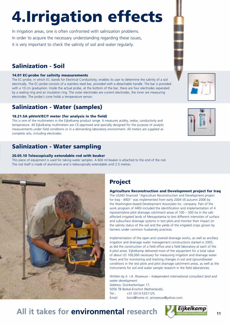
Salinization - Soil 14.01 EC-probe for salinity measurementsThe EC-probe, in which EC stands for Electrical Conductivity, enables its user to determine the salinity of a soil electrically. The EC-probe consists of a stainless steel bar, provided with a detachable handle. The bar is provided with a 10 cm graduation. Inside the actual probe, at the bottom of the bar, there are four electrodes separated by a sealing ring and an insulation ring. The outer electrodes are current electrodes, the inner are measuring electrodes. The probe’s cone holds a temperature sensor.
Salinization - Water (samples) 18.21.SA pH/mV/EC/T meter (for analysis in the field)This is one of the multimeters in the Eijkelkamp product range. It measures acidity, redox, conductivity and temperature. All Eijkelkamp multimeters are CE-approved and specially designed for the purpose of analytic measurements under field conditions or in a demanding laboratory environment. All meters are supplied as complete sets, including electrodes.
Salinization - Water sampling 20.05.10 Telescopically extendable rod with beakerThis piece of equipment is used for taking water samples. A 600 ml beaker is attached to the end of the rod. The rod itself is made of aluminium and is telescopically extendable until 2.5 metres.
ProjectAgriculture Reconstruction and Development project for IraqThe USAID financed “Agriculture Reconstruction and Development project for Iraq - ARDI” was implemented from early 2004 till autumn 2006 by the Washington-based Development Associates Inc. company. Part of the work program of ARDI included the identification and implementation of 4 representative pilot drainage catchment areas of 100 – 500 ha in the salt-affected irrigated lands of Mesopotamia to test different intensities of surface and subsurface drainage systems in test plots and monitor their impact on the salinity status of the soil and the yields of the irrigated crops grown by farmers under common husbandry practices. Implementation of the open and covered drainage works, as well as ancillary irrigation and drainage water management constructions started in 2005, as did the construction of a field office and a field laboratory at each of the 4 pilot areas. Eijkelkamp delivered most of the equipment for a total value of about US 100,000 necessary for measuring irrigation and drainage water flows and for monitoring and tracking changes in soil and (ground)water conditions in the test plots and pilot drainage catchment areas, as well as the instruments for soil and water sample research in the field laboratories.
Written by Ir. I.A. Risseeuw – Independent international consultant land and water development.Address: Duinkerkenlaan 17, 5056 TB Berkel-Enschot (Netherlands). Tel.: +31 (0)13-5331125. Email: [email protected], [email protected].

Nijverheidsstraat 30, 6987 EM Giesbeek, The Netherlands
T +31 (0) 313 88 02 00F +31 (0) 313 88 02 99
E [email protected] www.eijkelkamp.com
R e p l y F o r m Personal detailsCompany/Institute : …………………………………………………………………….... Contact : Mr./Mrs. ……………………………………………………………Address : ………………………………………………………………………Code and City : ………………………………………………………………………Country : ………………………………………………………………………Telephone : ………………………………………………………………………Telefax : ………………………………………………………………………E-mail : ………………………………………………………………………
Surface Irrigation