review of wetland and aquatic ecosystem in the lower …€¦ · · 2011-11-141 final report...
TRANSCRIPT
1
FINAL REPORT
Review of Wetland and Aquatic Ecosystem in the Lower Mekong River Basin of
Cambodia
By
Kol Vathana Department of Nature Conservation and Protection
Ministry of Environment Phnom Penh, Kingdom of Cambodia
Submitted to
The Cambodian National Mekong Committee Secretariat (CNMCS)
and THE MEKONG RIVER COMMISSION
SECRETARIAT (MRCS)
August 2003

2
TABLE OF CONTENT I. INTRODUCTION..................................................................................................................6 II. WETLAND BIODIVERSITY ..............................................................................................9
2.1 Current Status...................................................................................................................9 2.2 Ecosystem Diversity ........................................................................................................9
2.2.1 Freshwater Ecosystem ..............................................................................................9 2.2.2 Coastal and Marine Ecosystem...............................................................................12
2.3 Species Diversity ...........................................................................................................15 2.3.1 Fauna.......................................................................................................................15 2.3.2 Flora ........................................................................................................................19
2.4 Genetic Diversity ...........................................................................................................20 III CAMBODIAN WETLANDS SYSTEM ............................................................................20
3.1 Wetland Classification System ......................................................................................20 3.1.1 Systems of Wetland Habitats ..................................................................................21 3.1.2 Categories of Wetland Habitats ..............................................................................22 3.1.3 Wetland Sub-categories and Dominance Types .....................................................23 3.1.4 The Water Regime ..................................................................................................25 3.1.5 Artificial Modifiers .................................................................................................26
3.2 Major Wetland Types ....................................................................................................26 3.3 Cambodian Important Wetland sites..............................................................................29
3.3.1 Freshwater Wetland Sites .......................................................................................29 3.3.2 Brackish Water Wetland Sites ................................................................................29 3.3.3 Marine Wetland Sites..............................................................................................30 3.3.4 Regionally Significant Sites....................................................................................32 3.5.5 Internationally Significant Sites “RAMSAR SITES”.............................................33
3.4 Key Stakeholders within the Wetlands Management ....................................................34 3.4.1 Key Government Stakeholders ...............................................................................34 3.4.2 Non-governmental Stakeholders.............................................................................52
3.5 GOVERMENT POLICIES AND PLANS.....................................................................54 3.5.1 National Planning Framework ................................................................................54 3.5.2 National Legal and Policy Framework ...................................................................56 3.5.3 International Laws, Treaties, and Conventions.......................................................60 3.5.4 Existing Wetland Management Plans .....................................................................60
IV. Data and information related to Wetlands .........................................................................61 4.1 Data available.................................................................................................................62 4.2 Data uses ........................................................................................................................63
V. EXISTING INITIATIVES RELATED TO WETLAND MANAGEMNT........................64 5.1 National Activities .........................................................................................................64 5.2 Regional Activities.........................................................................................................67
VI. CONSTRAINTS IN WETLAND MANAGEMENT AND CONSERVATION ..............69 6.1 Policy Constraints ..........................................................................................................69 6.2 Legal Constraints ...........................................................................................................69 6.3 Organizational Constraints.............................................................................................70 6.4 Human Resource Constraints.........................................................................................70 6.5 Law Enforcement Constraints........................................................................................71 6.6 Management System Constraints...................................................................................71 6.7 Financial Constraints .....................................................................................................72
VII. CONCLUSION ................................................................................................................72 VIII. RECOMMENDATION ..................................................................................................73
8.1 General Recommendation..............................................................................................73

3
8.2 Specific Recommendation .............................................................................................75 REFERENCES ........................................................................................................................77 ANNEX Annex I: Fish species in Boeung Veng...............................................................................79 Annex II: Fish species were caught by local people in Siem Bok .......................................82 Annex III: Wildlife species recorded in Boeung Veng through interviews...........................84 Annex IV: Species of wildlife sold in Stung Treng province................................................87 Annex V: Species of Flooded Forest Vegetation in along the Mekong River in Siem Bok.88 Annex VI: Flooded forest species in Boeung Veng, Stung Treng Province .........................89 Annex VII: Important Wetland Sites in Cambodia..................................................................90 FIGURE Figure 1: The System for the Classification of Wetlands....................................................21 Figure 2: Description of Classification of the Wetland Systems ........................................22 Figure 3: Description of the Classification of the Wetland Categories...............................23 Figure 4: Sub-categories for exposed substrate and open water .........................................24 Figure 5: Description of the Sub-categories of Aquatic beds..............................................25 Figure 6: Main Wetland Types............................................................................................28 TABLE Table 1: Area of Wetland of International Significance in Indochina .................................7 Table 2: Internationally Significant Bird Species Known from Cambodia .......................18 Table 3: Cambodian Land Use Classification for Wetlands..............................................28 Table 4: Matrix of role and responsibility of government agencies ..................................51 Table 5: Various Institutions in relation to Wetland Types in Cambodia..........................53
4
Acknowledgement The idea of developing this paper is to review the status of wetland management in Cambodia in order to seek for support in wetland management and conservation; to look at constraints, opportunities and existing wetland initiatives and to seek for collaboration and cooperation among wetland experts and institutions, which are stakes to wetland in order to develop further plans and activities for future management and conservation of wetland and their resources. This paper was prepared with financial support from MRCS and CNMC to conduct research for existing data and information related to wetland management in Cambodia. I am extremely grateful for support and encouragement through the process of development of this paper. Many thanks to Mr. Chin Samuth, Associate Environmentalist, MRCS for coordinating, facilitation and provision of many ideas and documents in fulfilling this paper until getting satisfactory results. My special gratitude's is also forwarded to the following persons:
1. Mr. Meas Sophal, Deputy Director of the Department of Nature Conservation and Protection, the Former National Project Director of the Inventory and Management of Cambodian Wetlands Project (Phase I);
2. Mr. Neou Bonheur, Deputy Director of the Department of Nature Conservation and Protection, and the Deputy Director of the National Secretariat on Tonle Sap Biosphere Reserve Management, Ministry of Environment;
3. Mr. Mam Kosal, Deputy Director of the Department of Nature Conservation and Management, Ministry of Environment; and the Former Director of Wetland Management, Cambodia;
4. Mr. Sok Vong, Head Office of Wetlands, Watershed and Coastal Zone; Department of Nature Conservation and Protection, Ministry of Environment; who is actively involved for the review and supports.
5. Mr. Srun Lim Song, Head of Aquaculture Office, Department of Fisheries; 6. Mr. Mao Kosal, Liaison Officer of the World Conservation (IUCN), Cambodia; and 7. Mr. Kim Sour, Senior Fishery Officer, Department of Fisheries, Who provided views,
comments, data, information and documents for the completion of this paper. Without valuable contributions from these persons, the paper would not be completed. I am especially grateful to His Excellency Dr. Hou Taing Eng, Secretary General of the Cambodian National Mekong Committee for initiating and providing strong leadership throughout the preparation of the paper. Finally, I extremely acknowledge the Environment Program Unit of the Cambodian National Mekong Committee, especially Mr. Heng Phearith, Environment Program Coordinator; and Mr. Hak Socheat, Associate Environment Program Officer, who provided consistent supports and assistances to successfully completed this review.

5
Abbreviations and Acronyms
ADB : Asian Development Bank CRG : Cambodia Royal Government CCZ : Cambodia Coastal Zone CDC : Cambodian Development Council CGIN : Cambodia Geographic Information Network CMWSP : Cardamom Mountains Wildlife Sanctuaries Project. CNMC : Cambodian National Mekong Committee CZM : Coastal Zone Management DoF : Department of Fisheries DoG : Department of Geography DNCP : Department of Nature Conservation Protection DNRAEDM : Department of Natural Resources Assessment and Environmental
Data Management. DBMS : Database Management System. EC : European Commission ETAP : Environmental Technical Advisory Programme. FFI : Fauna and Flora International. GIS : Geographic Information System. IO : International Organization IMCWP – I : Inventory and Management of Cambodian Wetlands Project phase 1,
MRC/DANIDA IUCN : The World Conservation Union JICA : Japan International Cooperation Agency MIS : Management Information System MoE : Ministry of Environment MoU : Memorandum of Understanding MRC : Mekong River Commission MUA : Multiple Use Areas MRD : Ministry of Rural Development MPWT : Ministry of Public Work and Transport MIME : Ministry of Industry, Mine and energy MAFF : Ministry of Agriculture, Forestry and Fishery NP : National Park NEAP : National Environmental Action Plan NGOs : Non Governmental Organization PAs : Protected Areas PL : Protected Landscape PIP : Public Investment Program RS : Remote Sensing SEDPI : Socio-Economic Development Plan I SEDPII : Socio-Economic Development Plan II ToR : Term of Reference WS : Wildlife Sanctuary WI : Wetlands International
6
I. INTRODUCTION
The term wetland means different things to different people. This is partly because of the enormous variety of wetland types and partly also because it is sometimes difficult to define their boundaries precisely. "Wetland" is a relatively new term for the society and especially for Cambodia. There are more than 50 definitions of wetland used around the world. There are some essential characteristics of wetlands: surface-water flooding or high water tables bring about conditions that require significant adaptation by plant and animal life and contribute to the development and the properties of the soil. Wetland classifications rely on biological, hydrological, soil, or geomorphological characteristics. One of the broadest and most widely used definitions of wetlands was adopted during a conference in Ramsar, Iran in 1971 which resulted in the Convention on Wetlands of International Importance Especially as Waterfowl Habitat, in short, the Ramsar Convention. According to the Ramsar Convention, wetlands are described as: "Areas of marsh, fen, peatland or water, whether natural or artificial, permanent or temporary, with water that is static or flowing, fresh, brackish or salt, including areas of marine water, the depth of which at low tide does not exceeded 6 m". The Kingdom of Cambodia is rich in wetland environments. Over 30% of the country is considered wetland (Map 1). Following internationally accepted criteria for wetland identification (defined by the Ramsar Convention) over 20% (36,500 km2) of the country may be classified as wetland of international importance. This represents over 5% of Asia's total area of wetland of international importance (Table 1). Cambodia's internationally significant wetlands can be divided into four areas: the Mekong River (468 km in length) and its floodplain; the Great Lake – Tonle Sap (between 13,000 km2 and 2,500 km2) and its floodplain; the Stung Sen River (c. 3,000 km2); and the Coastal Estuaries of Stung Koh Pao and Stung Kep. In addition, Cambodia has numerous other wetlands, notably streams, ponds, freshwater swamps and marshes, mudflats and seagrass beds. The Kingdom of Cambodia is closely linked to wetlands, both culturally and economically. Most of the population lives in wetland areas and the central part of Cambodia, being essentially a large wetland comprising floodplains and flooded forests, have been exploited by Cambodians for centuries. Wetland products harvested by local communities include food (fish, waterbirds, edible plants, animals, etc.), medicines, water and firewood. Wetland areas support rice and fish production – the primary sources of food for the vast majority of the population and currently Cambodia's most economically productive sectors. Fish and fish products are the single most important sources of protein for the Cambodian population, representing 75% of the animal protein intake (CNMC 1992). Wetlands provide nutrient-rich and sheltered habitats for fish (breeding, spawning and nursery areas or habitats for adults) and therefore they play a central role in the supply of animal protein in Cambodia. Agriculture is supported by water from wetlands. Wetland water may be stored for use in the dry season or withdrawn for irrigation purposes. Other economic activities utilizing wetland resources include aquaculture, tourism, inland transport and energy (hydro-electricity).

7
Wetlands serve a wide variety of ecological functions which support economic activities or are of economic value. In addition to supporting agriculture and fisheries, they play a vital role in maintaining water cycle and protecting inland areas from flooding. Coastal wetlands act as barriers against storm surges and protect coastline from erosion. Many wetlands are important as filtering systems cleaning up polluted water and removing silt, encouraging plant growth and further improving water quality. Cambodia's wetlands are important sanctuaries for birds and other species of wildlife not commonly found in other countries in the world. They are also important for research and educational purposes. Cambodia is unique within Southeast Asia in that it retains large area of wetlands untouched by development. However Cambodia's wetlands are threatened by a variety of human activities including drainage for agriculture; agricultural run-off carrying pesticides and fertilizer; deforestation and forest clearing for firewood and charcoal, especially in the flooded forest; domestic waste and mining activities. Although industrial pollution does not pose a problem at the moment, it is expected to increase with the development of paper and textile mills, chemical factories and food processing industries. Major development projects such as irrigation and hydro-electric dams are likely to be implemented in coming years with inevitable impacts on wetland resources. In order to be proactive to address potential problems above, Cambodia requires not only a Clear Coordinated National Wetland Policy and a Comprehensive National Wetland Action Plan, but also the urgent study, research and implementation of wetland management should be in place for the time being. This paper is aiming to review the current status of the wetlands in Cambodia and to seek possibility for continuing actions in contributing the sound and effective management of the wetlands through out Cambodia. Table 1: Area of Wetland of International Significance in Indochina
Country Area of Wetland (km2)
% of country's land area
% of Internationally Important Asian Wetland Area
Vietnam Cambodia Thailand Lao PDR
58,10036,50025,1002,220
17.620.24.90.9
7.95.03.40.3
Source: A Directory of Asian Wetlands (Scott & Poole, 1989)

8
Map 1: Cambodian Wetlands Coverage in the Mekong Basin

9
II. WETLAND BIODIVERSITY
2.1 Current Status The term "biological diversity" or "biodiversity" refers to the total wealth of life found on earth. It encompasses of the entire variety of animals, plants and micro-organisms, as well as the ecosystems and ecological processes to which they belong. Biodiversity is usually recognized as having three distinct levels: genetic diversity, species diversity and ecosystem diversity. Cambodia falls within the Indo-Malayan realm along with Lao PDR, Vietnam and eastern Thailand. Its importance for biodiversity is possible greater than that of neighboring countries because of the relative abundance of natural habitats, particularly of lowland forests and wetlands and associated fish, partial studies on Cambodia's flora and limited studies on selected species of wildlife. Little is known about numbers, distribution of life cycles of most species in Cambodia. Wildlife is believed to be threatened by accelerated habitat pressure, hunting, trade and landmines. Miscellaneous observations and anecdotal evidence suggest substantial reductions in the abundance and distribution of rare or endangered species since the 1960s. A number of field surveys for large mammals and large waterbirds which carried out by IUCN in collaboration with AWB in 1994 confirm this. DANIDA – Environmental Management of the Coastal Zone Project has been doing a coastal resource profile and found that there is heavy threat and use pressure o coral reef habitat (Vann Monineat, Pers. Comm. 1998).
2.2 Ecosystem Diversity
2.2.1 Freshwater Ecosystem The freshwater ecosystems are the heartlands of the Cambodian society. Though they constitute the minority of the land area they provide home and sustenance to the vast majority of Cambodians, whose agricultural traditions (rice and fish production) revolve around the annual flooding of these areas. According to Nicolaas Van Zalinge, Nao Thuok and Sam Nuov (2001), the average fish consumption of 4.2 million people in central Cambodia is 67 kg/person/year and for the nation-wide fish consumption is probably close to 40 kg/person/year. Most fresh fish or fish products (e.g. prahoc) are still very cheap and affordable for the rural poor. After rice, fish is the most important food item on which people spend money for, then there is no other food supply – readily available and cheap, that can replace fish in the diet of the Cambodian people. Cambodian freshwater wetland habitats - streams, ponds, lakes and swamps, which support a high diversity of fish and a number of other freshwater animals and are renowned for their high productivity, with annual harvests having exceeded 100,000 tones for several decades. On a per hectare basis this was nearly ten times more productive than the North Atlantic Sea fishery (Dennis 1986). The high productive capacity of these waters is associated with inputs of terrestrial nutrients (Pantulu 1986b). The major habitats are as follow:

10
River Basins Rivers are the range of habitats includes headwater and tributary streams, the extensive meandering plains tracts which feature sandy gravel bars, deep pools up to 100 m deep and several kilometers long and, particularly north of the basaltic areas of Kampong Cham, numerous rapids. Brackish water develops seasonally in the Mekong delta provinces where a daily tidal influence is also present. Important river basins in Cambodia, which may be of international importance, include Tonle Sap, Tonle Mekong and Stung Sen. Rivers provide a wide range of benefits, both at national and community levels. These form an important channel for migratory fish to enable the exploitation of nutrient sources found in rivers, lakes and marshes. In Cambodia these is extensive fish migration through out the Tonle Sap and Mekong River Basins frequently perform important flood control and regulation of flow functions. The main threats to the river basins are siltation, water impoundment, and water pollution, over-exploitation of fish and clearing of riverine and floodplain vegetation. Mekong River Basin At 4,800 km in length the Mekong River is the longest river in Southeast Asia. It originates from the snowmelts of the Himalayan Mountains in China and passes through Myanmar, Thailand, Lao PDR, Cambodia and Vietnam before discharging into the South China Sea. The average annual discharge of the Mekong River to the South China Sea is estimated to be more than 500 billion m3 per year, with a total drainage area of 795,000 km2. This makes the Mekong River one of the world's largest river systems. The Mekong River enters Cambodia from Lao PDR in the northeast and flows southwards towards Phnom Penh. As the river flow between Lao PDR and Phnom Penh it divides into channels at several locations creating large islands and sandbanks. The river forms a fluvial lowland landscape with high natural levees, broad floodplains and extensive backwater swamps, many of which remain flooded through out the dry season. The Mekong delta begins downstream of Kampong Cham and extends into Vietnam. It is a vast fertile plain covering 49,520 km2, of which 16,000 km2 is situated in Cambodia. Below Phnom Penh the Mekong delta is formed by both the Mekong and Bassac Rivers. The Mekong River exhibits pronounced seasonal variation in flow. Water levels are lowest in April and May and highest in September or October. By the end of April many water bodies are isolated and the smaller tributaries tend to dry out. With the start of the monsoon rains in late May the river may start to rise and attains its maximum in September or October. Perhaps the most interesting aspect of the Mekong River System is its seasonal relationship with the Great Lake – the Tonle Sap Lake. Through out the year, the Tonle Sap Lake is fed by rivers within its own drainage basin and by direct rainfall. During the wet season however (April to October) the Mekong River swells to such an extent that its water push into the Tonle Sap River, forcing it to reverse its course and flow back into the Tonle Sap Lake. Around October, as the Mekong River subsides, the water stored in the Tonla Sap Lake starts flowing again towards the sea via the Tonle Sap River and onwards to the Mekong and Bassac River. Due to the unique hydrology of the Mekong – Tonle Sap River system, the floodplain around Tonle Sap Lake is inundated annually. This inundation is the most important factor influencing the productivity of Cambodia's fisheries and rice farming.

11
Consequently, any activity that alters the flow of the Mekong River will impact fishing and agricultural activities. Over 90% of Cambodia is within the Mekong River Basin. The Mekong River and its floodplain is the most densely populated area in the country (110 – 500 persons per km2). Phnom Penh is situated in this area, with an estimated population of more than 1 million.
Lakes Lakes are distributed through out Cambodia. There are many shallow, sometimes seasonal lakes in the lowlands and a variety of lakes, including volcanic lakes, in mountainous areas. Lakes are important for domestic, agricultural and industrial water supply; flood control and flow regulation; hydroelectric power generation; aquaculture; wildlife habitat; and the conservation of genetic resources. The most important lake in Cambodia is Tonle Sap Lake. The Tonle Sap Lake, with the area of 2,500 km2 and up to 13,000 km2 in dry and wet season respectively, is the largest in Southeast Asia, and may be the largest floodplain lake in the world. At low water level the lake is about120 km long and up to 35 km wide. It is very high productive water body that plays a vital role in maintaining fish production, aquatic life and biodiversity. The Tonle Sap Lake and its floodplain are classified with regards as international significant wetland and as Biosphere Reserve. The main threats to the lakes are sedimentation and water pollution arising from domestic wastes, agricultural run-off, mining activities and detrimental fishing practices. Beside the Tonle Sap Lake, Cambodia's lakes have not been studied so far.
Seasonal Wetlands During the wet season up to 30% of Cambodia's total land area may be flooded. As the water recedes, a number of seasonal wetland areas are created, some of which retain water into the dry season. These areas are significant in term of fish spawning ground and other habitats for animal species, including birds. Seasonally inundated wetlands also provide nutrients for aquatic ecosystems.
Flooded Forest, Freshwater Swamps and Marshes Cambodia has extensive areas of flooded forest, located on the margins of the Tonle Sap Lake, the Mekong River, the Tonle Sap River and other wetlands. Tonle Sap Lake is surrounded by a broad belt of freshwater swamp forest, generally some 20 – 30 km wide but extending up to 65 km in the province of Battambang. These forests occur naturally around the Tonle Sap Lake and along the Mekong and Tonle Sap Rivers. The flooded forests are dominated by a number of small to medium-sized trees and numerous shrubs. These flooded forests in conjunction with the surface run-off and inflow from the Mekong through Tonle Sap River play crucial role in the provision of nutrients necessary to sustain a large and varied biota. Notable aquatic fauna are three species of dolphin, otters, fishing cats, freshwater turtles, tortoises, crocodiles and a great range of waterbirds. The destruction of flooded forests has been occurring for some time, and is almost certainly having a significant deleterious effect on the populations of some fish species. Around the Tonle Sap Lake, the area of flooded forest has been reduced from 800,000 ha in the early 1970s to 300,000 ha in the late 1980s (Dennis & Woodsworth, 1992). The flooded forest is cleared mainly for timber, firewood and for conversion to agriculture.
12
The associated flooded forest covers 1.2 million ha of grassland and other swampy areas susceptible to flooding. Swamps and marshes also occur in a number of other locations. They provide important benefits such as flood control and water regulation, water supply, aquifer recharge, and wetland habitats. The greatest threat to swamps and marshes in Cambodia is drainage and conversion to other uses such as rice fields and fishponds, and siltation from unsuitable land uses in the catchments areas.
2.2.2 Coastal and Marine Ecosystem The Cambodian coastline extends along 435 km of some of the least populated areas in all of tropical Asia (Collins et. al. 1991). The coastal region features a number of closely interrelated ecosystems, embracing beach forest and strand vegetation, mangroves (including a Melaleuca dominated swamp forest referred to as "rear mangrove", estuarine ecosystems, seagrass bed, coral reef and the unstudied marine ecosystems of the gently sloping, relatively shallow seabed (only 80 m of water depth at the outer limit of the 200 nautical mile Executive Economical Zone), and of water column above. These complex of coastal and marine ecosystems combines to maintain a diversity of biota which is significant not only in terms of biological diversity but also is of direct economic significance to Cambodia and, indeed, for all other countries situated around the Gulf of Thailand. Having remained relatively isolated from core areas of human activity, the level of exploitation of the coastal resources is much less than in neighbouring Thailand or Vietnam, and in Malaysia, across the Gulf.
2.2.2.1 Coastal Forests The tropical evergreen forests which occupy most of the southerly fall of the Cardamom and Elephant ranges are amongst the most extensive and least disturbed in mainland Southeast Asia. They are said to "harvest" water from the sea, particularly during the south-west monsoon. The annual rainfall, between 2000 and over 5000 mm, is the highest in Cambodia. These forests, located in the catchments of the Metoek, Kuot, Russei Chrum, Kep, Sala Munthun, Trapeang Rung, Piphot, Sre Ambel and Veal Rinh rivers where it needs to protect for the regulation of water flow and nutrients to the near coastal waters. A range of formations occur in the near coastal zone. These forests occur in sheltered coastal sites where sufficient muddy sediments, can accumulate. There are two tides a day which situate in the intertidal flat. Mangrove forests are recognized for their high biological productivity and their consequent importance to the nutrient resources to adjacent of coastal waters. They also protect the shoreline from erosion. In Cambodia the trees of these forests usually occur in four zones. From seaward to landward edge these are (i) the Avicennia-Sonneratia zone, (ii) the Rhizophora zone, (iii) the Bruguiera-Kandelia-Ceriops zone and (iv) the Lumnitzera-Xylocarpus-Bruguiera zone (Vidal, 1978). However, zonation patterns may not always strongly develop. In reference to areas bordering to Bay of Sihanoukville Dy Phon (1970), notes that the regeneration of species differs from place to place according to the physical and chemical properties of the soil.
13
Immediately at the near of mangrove forest is a vegetation formation dominated by Melaleuca leucadendron, through with some trees and shrubs characteristic of mangroves and, often the distinctive large fern of mangrove areas, Acrostichum sp. Some palms, notably the highly useful and marketable Nipa fruticans may also be presented. This formation is not normally inundated by the tides though the highest tides may reach them at some sites. However, they are frequently flooded through the retention of rainwater and run-off. Inland from these forests a generally three-tiered "swamp forests" may occur associated with muddy alluvial soils in depressions (Vidal, 1978). Mangroves in the Gulf of Thailand have greatly deteriorated over recent decades. Cambodia's proportional loss has perhaps been less than other countries of the Gulf. Even so, it has been significant. Undisturbed mangroves now occur only in Koh Kong (Larsson 1992).
2.2.2.2 Inshore Marine Ecosystem The diverse Cambodian coastline possesses sandy, muddy and rocky shore associated with saegrass flats and, in place, coral reefs. Inshore reefs appear to be less well developed than those further offshore in the vicinity of islands such as Koh Tang, probably because, inshore, sedimented freshwater discharges from rivers inhibit coral development. Dugong and sea-turtles, as well as dolphin, are known from the area but there is no information on their status. These species are becoming increasingly rare in other parts of the Gulf. Mangroves The total area of Cambodia's mangroves, which include areas of true mangrove and rear mangrove, is estimated to be less than 60,000 ha. Much of this area is in Koh Kong province where approximately 16,000 ha of true mangrove occur. The coast of the Bay of Sihanoukville also features about 13,621 ha and 39,066 ha of mangrove and rear mangrove respectively, and these areas has not been exploited commercially but were utilized by local habitants. Relatively intact mangroves are found at Peam Krasop, Andong Toek, Sre Ambel, and Chhork Srecham, Prek Kampot (Bann 1997). There are about 43 to 45 species of the true mangrove (S.Vong 2003). Mangroves in Cambodia are threatened by firewood collection, and cutting for charcoal production, aquaculture, expansion of salt pan and wood chipping operations. In addition to destruction of mangroves for charcoal production, in 1993 an international company invested with the government in a mangrove concession in Koh Kong. The company had planned to harvest mangrove products at a rate of 10,000 tons per year. A year later the company cancelled the project. Mangroves have also been cut down by poor people for fuelwood or scent production. When the salt price went up in 1997 – 1998, large area of mangrove in Kampot province was cleared for expansion of salt pan. Moreover, the intensive aquaculture had been introduced in cleared mangrove areas in Koh Kong province. Mangrove habitats are often not appropriate for long term aquaculture and not all coastal sites are suitable for development of aquaculture. The adverse impact of shrimp culture on mangrove areas needs to be weighed against the benefits shrimp aquaculture development. By 1994, the Department of Fisheries (DoF) had given licenses for 840 ha of mangrove land for intensive shrimp production (Pisey et al, 1994). Shrimp farms are normally found along the waterways and the fringe of coastal water where relatively intact mangroves are grown.

14
Estuaries and Mudflats Estuaries are semi-enclosed bodies of water that are connected to the sea and in which salt water is diluted by fresh water from land drainage. Estuaries are often highly productive areas due to the nutrients they receive from the land and the sheltered environments that they provide. The major estuarine areas in Cambodia occur in the region around Koh Kong province and near Kampot province. The Stung Koh Pao and Stung Kep estuaries are recognized as wetlands of international significance. Both rivers originate in the Cardamom range and discharge their flow into Koh Kong Bay. The Bay is protected from southwest storms by the large island of Koh Kong. According to Scott (1989), the estuarine system is "a complex of channels and creeks, low islands, mangrove swamps, tidal mudflats and coastal lagoons". Mudflats occur when sediment settles out of the water due to a decrease in current and/ or wave action. Mudflats are often associated with estuaries, but also occur in a low energy coastal environments, such as in large bay or in the lee of islands. There are commonly continuous with mangrove areas. Mudflats can be very productive system as a result of nutrients recycling through the sediments. Typically there are high diversities of invertebrates living in and on the mud, and as a result the mudflats provide rich feeding grounds for vertebrates such as fish and waterbirds. Mudflats adjacent to the mangroves and in natural mangrove streams are exploited for cockles, although this is generally an unrewarding activity practices only by those with no alternative from of income. The productivity of estuaries and mudflats is threatened by pollution from a range of sources, e.g. construction activities outside mudflats can have adverse effects by causing in the flow of water, which either erodes the mudflats or prevents further deposition. The location, extent and significance mudflats areas in Cambodia are not adequately known. Seagrass Beds Seagrass are often found on shallow sediments and are often well developed on submerged reef flats, particularly on the platforms of fringing reefs where they are commonly associated with algal beds (seaweed). The productivity of some seagrass areas is very high. As well as providing nursery areas, shelters and feeding sites for a range number of invertebrates and fish, many of which are economic importance, seagrass beds are important feeding areas for endangered vertebrates such as the dugong and marine turtles. Furthermore a significant proportion of the nutrient produced by seagrass beds can be transferred to adjacent ecosystems such as coral reefs. Virtually little is known of the location, extent and significance of seagrass beds in Cambodia. Some recent information on seagrass is made available through a brief coastal resource profile documented by DANIDA coastal zone management project. Coral Reefs There is limited available information on the distribution of coral reefs in Cambodia. A number of Cambodia's offshore islands are known to contain substantial areas of coral reefs but little is known of the diversity of plants and animal species in these areas. A coastal

15
resource profile documented by DANIDA coastal zone management project has provided information of the location and extent of the coral in the nearshore of the Cambodia's coast. Due to their physical structure, coral reefs provide niches for a wide variety of invertebrates and fishes, resulting in a significantly higher species abundance and diversity than would occur in the open water. Extraction and collection of coral is commonly practicing by local people in Cambodia. There is a concern that these practices will result in habitat loss and related biodiversity loss.
2.2.2.3 Offshore Marine Ecosystem Very little is known of the marine biota and ecosystems. In comparison with other parts of the Gulf of Thailand Cambodian waters have been lightly exploited. Cath-per-unit effort reportedly is ten times that of adjacent depleted waters (Csavas, 1990). The Gulf's fisheries suffered dramatic over-fishing following the mechanization of Thailand fishing fleet in the 1960s. This resulted in a loss of biological diversity and the Gulf became dominated by invertebrates (Dennis and Woodsworth, 1992). The importance of Cambodia's marine waters lies not only in its relatively light level of exploitation but also in the potential for a measure of rehabilitation of the depleted fish stocks of the entire Gulf from larval and juvenile dispersal from Cambodia's inshore waters. However, the survey of the ecology of the Gulf of Thailand and the South China Sea was carried out by Naga Expeditions from 1959 to 1961 (Scripps Institute 1962). This was at a time when declines in fish catches were first recognized. It identified coastal waters in general and those off Cambodia in particular, as zones of high biological productivity and important nurseries for fish breeding in the Gulf. These zones are associated with the seasonal reversal of monsoon winds which assists the movement of nutrients to the surface, tidal mixing, and the highest counts of fish larvae (Rastrelliger spp., total anchovy laevae and total fish larvae). The ecology of Rastrelliger spp. highlights the importance of the Cambodian coastal waters. In the 1950s Rastrelliger spp. yielded an annual catch of approximately 50,000 tons, or 60% of Thailand's total marine fish landings. There two main populations of Rastrelliger within the Gulf. These are associated with major upwelling zones. One is located in the western portion near Koh Pennan and Koh Samui and enriches the western nearshore portion during the north-east monsoon. The other develops along the Cambodian coast during the transition from the north-east to the south-west monsoon, i.e. at a time when run-off from the coastal ranges entering the Gulf is at a maximum. Rastrelliger spp. breeds in both of these areas according to the season and associated enrichment of the water. Both of these populations move to the upper Gulf region to feed and subsequently return to their breeding grounds in preparation for the next season.
2.3 Species Diversity
2.3.1 Fauna The Wetlands in Cambodia has a very rich biodiversity. Yet many of the rare and endemic wildlife species which once were widespread over vast areas of particular habitats are now restricted to minor and isolated patches as a result of human pressures such as habitat conversion and hunting.

16
Many endangered animal species are found in Cambodia. According to Inventory and Management Cambodian Wetland Project (IMCWP-I), endangered species inhabiting Cambodia's wetlands include: Aquatic species
Irrawady Dolphin Orcaella brevirostris Ido-Pacific Hump-backed Dolphin Sousa chinensis Siamese Crocodile Crocodylus siamensis Giant Catfish Pangasianodon gigas Trey Trasak Probarbus jullieni
Waterbirds
White-winged Duck Cairina scutulata Sarus Crane Grus antigone Giant Ibis Pseudibis gigantea White-shouldered Ibis Pseudibis davisonii Greater Adjutant Stork Leptoptilos dubius Lesser Adjutant Stork Leptoptilos javanicum Milky Stork Mycteria cinerea Spot-billed Pelican Pelecanus philippinensis
The Tonle Sap Lake is considered as crucial habitat for Pelecanus philippinensis, Leptoptilos dubius, M. cinerea, Darter Anhinga melanogaster and Asian Openbill Anastomus oscitans. Most wetland species have economical value for local communities and some play a significant part in local economies. Most markets in Cambodia have some wetlands species to sale. Some species such as the Malayan snail-eating turtle (Malayemys subtrijuga), are an important source of income and are traded across national border. Little information exists on freshwater turtles and tortoises, but there are a number of rare and endangered species including Batagur baska. Other rare and endangered species requiring further investigation include the otter, the dugong and the sea turtle. Other aquatic vertebrate found in the Cambodian wetland are Siamese crocodile, a range of tortoise and turtle species, including several soft-shelled turtles; freshwater snakes; and a wide range of amphibians. The Siamese Crocodile has a restricted distribution. It is found only in the tropical lowlands of mainland Southeast Asia (Thailand, Lao PDR, Cambodia and Vietnam). It occurs fairly widely in Cambodia, but it is threatened. There are about 157 individual of this species living in the wild (2003 Forest Administration report). In contrast to this specie occurs in crocodile farm surrounding Tonle Sap Lake more than ten thousand individuals. The Cambodian Wetlands supports one of the world's largest inland fisheries as well as having a highly diverse fauna in fish, mollusk, amphibian and reptile groups. Over 850 species of fish have been recorded in the lower Mekong River and the Great Lake. However many are uncommon and little is known among of several hundred species. Bardach, 1959, noted 18 of fish species are the principal commercial species and other 36 fish species are the economic significance. These fish species occupy in variety of niches including planktivory,
17
detrivory, predators and opportunists. A range of other adaptations are also evident and enable the recognition of two ecologically complementary groups – "white fish" and "black fish". The "white fish" require water of higher oxygen content and lower pH fluctuations than the "black fish". "White fish" migrate annually to the Great Lake and floodplain areas from the mainstream and tributaries during the risen season of the Mekong floodwaters. The black fish are the permanent residents' of the lake such as murrels, anabantids, catfish (Clarias, Saccobranchus), spiny eels and Oxyeleotris. They are able to utilize atmospheric oxygen using accessory respiratory structures. Many are capable of overland travel and can thereby avoid inhospitable oxygen within poor environments. The pattern of migration and habitat utilization of fish also depend upon the development and ebb of the flood. With the ebb of the floodwaters "white fish" leave the flooded forests for the open waters of the lake, mainstream or tributary channels. Many of the carps simply spawn in the proximal inundation zone and quickly move out with receding waters. Other such as tributary catfish undergoes considerable lateral migration across floodplains for tributaries. Some mainstream fish spawn in the mainstream and the eggs and fry are carried into the floodplains where further development and growth occur. "Black fish" remain in peripheral forests and similar flooded areas until the dry season advances whereupon they attempt to move back to open water. So, the timing and level of the flood in any one year ma any have a critical impact upon the success of fish breeding. This leads to the idea that variability in the flood regime from year to year may be one of the factors which contributes to high fish diversity, stock and production. According to Pantulu (1986b), the dry season fish fauna is dominated by species of Carp (Cyprinidae) – 54%; Catfish (Siluridae), Claaridae, Schiberdae, Bagridae and Akisidae – 19%; and Channidae – 8%. The remaining 19% consists of featherbacks (Notopteridae), herring (Clupeidae), climbing perch and gouramis (Anabantidae) and other miscellaneous groups. There is a high level of endemism in different parts of the system. There were few initiatives in studying species diversity in Cambodian wetlands, but the output of those studies were not concretely reported, except, the field study in Boeung Veng, Kratie Province and Siem Bok in Stoeng Treng Province by the Inventory and Management of Cambodian Wetland Project (IMCWP - Phase I). This project had focused on agriculture, wildlife, fisheries, socio-economic, environment and hydrology. The project had conducted surveys in two field sites along the upstream Mekong River, namely Boeung Veng in Prek Prasop District, Kratie Province and Siem Bok District in Srung Treng Province. The result of the survey in Boeung Veng site shows that the site is the biggest lake in Kratie Province and is rich in fish. The lake has the potential to support enough fish for local people living around the area. In the future, fish stock will decline and some fish species will be lost, if there is no any measure against flooded forest clearance, which causes to lost fish habitat for spawning and breeding. There are 52 fish species were recorded in this area (Annex I). It is also reported that Siem Bok District supports good condition for fish habitat, spawning and breeding grounds especially for the rare species such as Mekong Giant Catfish (Trey Reach), Giant Barb (Trey Kol Reang), Mekongina exytrophila (Trey Pasi I). The highly endangered Irrawaddy Dolphin also depends partly on some of these habitats. This is due to the areas' richness in supporting good Zooplankton and Phytoplankton levels, and the presence of productive habitats such as flooded forest and large and deep river pools. There was reported of 71 species were caught by local people in this site (Annex II).

18
Wetland mammals are a significant part of the Cambodian wetland biodiversity, including the smooth-coated otter, the fishing cat and the three species of dolphin, namely Irrawaddy dolphin (Orcaella brevirostris), the Indo-Pacific Hump-backed Dolphin (Sousa chinensis) and the black finless porpoise (Neophacaena phocanoides) (David A. Ashwell in collaboration with DNCP, MoE, 1997). A range of terrestrial animals such as Tiger, Elephant, Gaur, Kouprey and wild dog are dependent on wetlands, particularly during the dry season. Besides of the mammals Cambodia, a number of bird species that have declined in abundance in some neighboring countries; and are possibly on the verge of extinction in those countries. In particular, Cambodia's vast wetlands feature with substantial numbers of diversity of large waterbirds. These include a number of storks (black-necked, lesser adjutant and greater adjutant, milky, open-billed, painted and wooly-necked), ibis (black-headed, giant and White-shouldered), spot-billed pelicans, darters, white-winged duck and sarus cranes (barzen 1995; desai and Lic 1996; Mundkur et. al. 1994; and Parr 1996). It was reported that the overall status of large waterbirds is one of decline. The Cambodian wetland is important to a large number of restricted ranges of waterbird species, many of which are threatened or critically endangered. It is known that at least five species of large waterbirds depend for their survival on conservation measures which need to be taken within the Mekong River Basin, while 24 species have substantial part of their world population in the region. Table 2 shows Internationally Significant Endangered and Threatened Species of birds found in Cambodian wetlands. The full significance of the avian biodiversity of the Cambodian wetlands is not yet known. Decline of a number of other species are also apparent. Sarus cranes have been observed on Tonle Sap and to breed in north-eastern Cambodia. However, they continue to migrate to the nearby Tram Chim reserve across the border in Vietnam. Even the rediscovery of the giant ibis should be viewed with care, this species was once widely distributed and known even from populated areas as close to Phnom Penh as eighteen kilometers (Thomas 1964). It is currently known only from remote areas of the country. According to the National Wetland Team (IMCWP – Phase I), some species of wildlife occurred in Boeung Veng before 1980, but they lost from the area nowadays, such as; Glossy Ibis, Woolly-necked Stork, Greater Adjutant and Lesser Adjutant. There were a lot of Cormorants before but now they have declined and Oriental Darter is almost lost from the area. There are 51 wildlife species were recorded from Boeung Veng site (Annex III). It is confirmed that there are some globally threatened wildlife species exist in Siem Bok District, e.g. Greater Adjutant, Sarus Crane, Spot-billed Pelican. Some other near threatened species such as Oriental Darter, Painted Stork, Comb Duck, Red-headed Vulture, White-rumped Vulture were also confirmed to be present in this area. It was also reported that wildlife trade and hunting is still secretly continuing in Stung Treng Province. The following animals have been noted as trapped or killed Thick-billed Pigeon, Yellow-footed Pigeon, Parakeets, Monotor lizards, Pangolin, Cobra, python, Red Muntjac, Sambar, Monkeys etc. This species are sold in Stung Treng Province and other provinces as well as exported to the neighboring countries. In 2000, there are 16 species of wildlife were recorded to be sold in Stung Treng Province (Annex IV). Table 2: Internationally Significant Bird Species Known from Cambodia

19
Rare and Regionally Endemics
IUCN Red List
GENUS SPECIES COMMON NAME
V Aegypius Monachus Cinereous vulture R Haliaeetus Leucoryphus Pallas's fish-eagle V Cairina Scutulata White-winged duck
En Coracina Polioptera Indochisese cuckoo-shrike En Megalaima Incognita Moustached barbet
I Ciconia Episcopus Woolly-necked stork V Ibis Cinerus Milky stork E Leptoptilos Dubius Greater adjutant V Leptoptilos Javanicus Lesser adjutant R Caloenas Nicobarica Nicobar pigeon
En Carpococcyx Renauldi Coral-billed ground cuckoo En Polihierax Insignis White-rumped falcon
V Heliopais Personata Masked finfoot Rare I Oriolus Melianus Silver oriole
E Eurodotis Bengalensis Bengal florican I Pelecanus Philippensis Spot-billed pelican
En R Arborophila Cambodiana Chestnut-headed partridge R Arborophila Charltonii Scaly-breasted partridge
En R Lophura Diardi Siamese fireback V Pavo Muticua Green peafowl
En Meiglyptes Jugularis Black-and-buff woodpecker
En Picus Erythrogygius
Black-headed woodpecker
En R Pitta Ellioti Bar-billied pitta I Padda Oryzivora Java sparrow
En Passer Flaveolus Plain-backed sparrow En Pycnonotus Blanfordi Steak-eared bulbul
Rare Philomachus Pugnax Ruff En Sturnus Burmannicus Vinous-breasted starling
E Platalea Minor Black-faced spoonbill I Pseudibis Davisoni White-shoulered ibis
Rare/ En R Pseudibis Gigantea Giant ibis En Garrulax Streppitans White-necked laughingthrush
(Survey of Inventory and management of Cambodia Wetland Project phase 1 1998)
2.3.2 Flora Cambodia has rich fauna and flora with particular diverse associations of aquatic vegetation in different wetlands types and flooded forests. Flooded forests extend through out the lowland areas of Cambodia, but their greatest extend is around the Tonle Sap Lake. The biodiversity of these habitats has been little studied, apart from very limited surveys in the Tonle Sap Lake, Stung Treng and Kratie province and coastal and marine areas. According to Pantulu, 1986b, the silt carried by the Mekong is nutrient deficient and it is likely that fish production is sustained by organic matter from terrestrial and aquatic plants. This material decomposes and is then consumed directly by algae, aquatic plants and some

20
fish. Central to the maintenance of these freshwater ecosystems are the adjacent "flooded forests". These forests occur naturally around the Great Lake and along the verge of the Mekong and Tonle Sap Rivers. They are dominated by Barringtonia acutangula, Terminalia chebula, Homalium brevidans, Hydrocarpis antelmica, Amelia asiatica, Cruedia chrysanthe and Hymenocardia wallichir. According to field survey by the wetland team of the IMCWP – Phase I, flooded forest along the Mekong River in Siem Bok district, Kratie Province still remains intact and is a very important habitat for fish spawning, breeding and feeding. Some areas of flooded forests have been cleared for agricultural purposes. There are 21 species of flooded forest vegetation were recorded along the Mekong River in Siem Bok district (Annex V). In spite of this, 32 species of flooded forest vegetation were found in Boeung Veng site, Stung Treng Province (Annex VI).
2.4 Genetic Diversity Genetic diversity refers to the variation in the genetic makeup among individuals within a single species. So far there is no an initiative or study on genetic diversity of the species within wetlands in Cambodia. There was reported by Tana, T.S. (1993), on the genetic diversity, which he bases on the spawning and migratory patters of groups of fish species, but he does not report on spawning and migratory pattern within any one species.
III CAMBODIAN WETLANDS SYSTEM 3.1 Wetland Classification System In the Cambodian Wetland Inventory, a site to be classified as a wetland, it must meet one of the following criteria:
• Plants able to tolerate inundation by water for a period of greater than 6 weeks (hydrophilic plants)
• Soils are classified as hydric soils • Area is inundated by water for a period on an annual and periodic basis (see below
for further explanation) A system for the classification of wetlands has been developed for Cambodia since 2000. This system provides for the classification of wetlands based on a number of characteristics. These characteristics allow for the classification into systems, categories, sub-category and modifiers that describe the wetland sites (Figure 1). This classification system proposes to describe the important characteristics of particular wetland sites. It considers the wetlands in terms of water regime, substrate, vegetation type, etc. In combination, these definable characteristics should be able to provide a clear categorization of each wetland type. This system can be called a "Hierarchical approach" to the classification of wetlands. This is a process to evaluate a particular set of characteristics through a series of levels related to the characteristics of each particular site. At each step of this process more detailed information is gathered to refine the description of the area. At the end of this process, the unique characteristics to identify the wetland habitat will be identified.

21
THE MODIFIERS
Figure 1: The System for the Classification of Wetlands
3.1.1 Systems of Wetland Habitats The first level of classification is system. The system level allows for the classification of wetland habitats into broad functional ecosystems. The system is classified into Saltwater Wetland System and Freshwater Wetland System. Saltwater Wetland System is classified into Marine and Esturine. In spite of this, Freshwater Wetland System is classified into Riverine, Lacustrine and Palustrine. Figure 2 represents the Cambodian wetland classification system.
System
Salinity
Wetland Category
Wetland Sub-category
Water regime
Plant Dominace
Artificial Modifier

22
Figure 2: Description of Classification of the Wetland Systems
3.1.2 Categories of Wetland Habitats This process can be made easier through the grouping and describing particular attributes of the wetland system. Wetlands do not simply comprise one type of habitat, thus an easily understandable approach is required to describe the habitat in more detailed terms. The categories of wetlands are based on the features of the wetland. Some of the features that can be used to categorize the wetland include the vegetation types, the presence of open water surfaces and the types of plant and animal communities that inhabit the area. Thus categorizes provide broad grouping of wetland types. These categories can be refined further through a series of sub-categories which describe the habitat in more detail. The system of sub-categories is provided in series can be broken into smaller categories. Types of wetlands can be classified according to the dominate types of vegetation, or if no vegetation is present, the types of substrate of the wetland area. It is important that wetlands can easily be grouped into contain categories. It is also very important that the wetland categories can be recognized from aerial photography and through field site visits. Wetland Category can be classified into Vegetated and Non-vegetated one. The Vegetated Wetland Categories can be classifies as Aquatic Bed, Coral Reef, Inundated Forest and Emergent and the Non-vegetated Categories can be classified as Bare substrate and Water surface. The figure 3 below summarizes the wetland categories.
Wetland
Saltwater Wetlands
Freshwater Wetlands
Marine Estuarine Riverine Lacustrine Palustrine

23
Figure 3: Description of the Classification of the Wetland Categories
3.1.3 Wetland Sub-categories and Dominance Types The purpose of this sub-category is to define in more detail the characteristics of the wetland site. This is very useful in beginning to describe in more detail the plants and substrates that are present at the site. It is also very important information for the planning of management actives. The Sub categories describe more detailed difference of the habitats based on:
• finer distinction in substrate material • finer classification of the vegetation types • other important characteristics.
There are three main sub-categories, namely Non-vegetated, Aquatic bed, Emergent Vegetation and Inundated forest. The Non-vegetated sub-category refers to those areas that are not covered in vegetation. They include areas that are covered by open water. The figure 4 below outlines the detail of this sub-category.
Wetlands Categories
Vegetated Non-Vegetated
Coral Reef
Inundated Forrest
Emerent Bare substrat
Water surface

24
Figure 4: Sub-categories for exposed substrate and open water The Aquatic bed group includes a range of plants that spend a high proportion, if not all of the time submerged in water. Some of these plants are able to withstand only short periods of exposure to the air (e.g. seagrass), however most are not able to cope with any lengthy period of exposure to air. These plants can be both aquatic and marine species. These plants are often in areas with slow moving water and where the water is less than 2 m deep. This term aquatic bed is used for a mixture of plants that grow on or near surface. Aquatic beds are very common in lakes, slow moving water bodies, and on the edges of rivers. These plants grow in permanent and seasonally inundated wetlands. Figure 5 below illustrates the detail of this sub-category. Emergent include those plants that are rooted in the substrate and whose stems, flower and leaves extends above the water surface. They maintain the same appearance year after year (e.g. reed beds), except during intense and prolonged dry periods. There are two groups of emergent, namely Persistent and Non-persistent. Beside the above-mentioned sub-categories, inundated forest also can be classified as other one sub-category. This includes areas that are inundated for a period of the year. This may range from few weeks to 11 months. All plants in this sub-category are able to withstand over 6 weeks on inundation. There three following groups within this subcategory.
• Scrubby inundated forest This subclass includes all wetlands with vegetation dominated woody shrubs and small flooded forest species. These may be immature forests that have been cut, or naturally occurring forest vegetation.
• Mature inundated forest
This includes areas that contain flooded forest over a height of 6 meters. These areas are dominated with vegetation of tall woody shrubs or trees. The area of
Non-vegetated Wetlands
Exposed Substrates
Water Surface
Mud Sand Cobbles- Gravel
Rock Organic
25
coverage of this site is where 50% or more of the species are evergreen. The area covers of vegetation is 30% or greater.
• Dead
This includes wetlands where dead trees and shrubs dominate the habitat. Including all wetlands with vegetation dominated by dead woody shrubs or trees. The area cover of vegetation is 30% or greater. These wetlands are usually produced by prolonged rises in the water table resulting from natural or man made causes. Such wetlands may also result from other factors such as fire, salt spray, air pollution, herbicide, etc.
Figure 5: Description of the Sub-categories of Aquatic beds
3.1.4 The Water Regime The water regime has the greatest influence on the creation and maintenance of wetland systems. In the Mekong Basin, the seasonal influences of the wet and dry season and the resulting change in water levels have a very pronounced on the distribution and function of wetlands. For example on Lake Tonle Sap, the annual height of inundation varies by up to 8 meters. The height of inundation directly influences amount of area that is inundated, thus is providing water for these wetland areas. Thus, to describe wetland systems, it is important to accurately describe the hydrology of the wetland. This is based on depth and length of inundation and also the period of drying. These factors have a profound effect on the determination of the nature of the wetland systems. There are three types of conditions for the water regime. Permanent water - Water covers the substrate throughout the year. These habitats include the permanent water bodies of lakes, rivers and ponds. These areas do not typically dry out, except during periods of intense drought. Seasonally inundated – Water occur higher level during the wet season. These areas may be dry for up to 6 months, and inundated during the rising water. In low water-wet season, this may be the maximum of the inundation. Intermittently flooded - This include areas that areas subject to flooding either from over banking of the Mekong and/or exceptionally rainfall. These areas may be flooded for a period
Submerged and attach
Submerged and
unattached
Rooted, but floating on
water surface
Free floating on
water surface
Aquatic Bed

26
one week through to one or two months. This may occur only during years of exception high rainfall and/or high water levels.
3.1.5 Artificial Modifiers Many wetlands in Cambodia have been modified for human-use. Examples of these areas include rice fields, field crops, shrimp farms and other modified wetlands. These categories should be used to describe the wetland areas in conjunction with the system described in the earlier. The main categories used to describe these areas are listed below:
1) Agricultural-Rice fields - The soil has been used for the production of rice. The soil surface may be in a number of forms including bare soil, stubble of rice, under preparation of the cultivation of rice and under production. This category is destined as a wetland.
2) Agriculture-Other crops - Used for the cultivation of other crops in wetland areas. This may be a range of species. This category is defined as a wetland if the agricultural activity was to cease and the areas would naturally change to a site denominated by hydrophilic plants
3) Spoil - An areas where the substrate has been created through the placement of soil, rock etc. from excavation activities.
4) Dike/impounded - Wetlands where the water regime has been modified to retain and manage the water system. This includes dams' reservoirs where the water is retained for irrigation and/or hydroelectricity production purposes.
5) Drained - Wetland area that has been drained for other uses. The water will rapidly run-off from this areas. It may support some hydrophytic plant species at certain times the year. Areas that have been lifted and used for other purposes (e.g. houses and factories) are not considered as wetland areas.
Not all these systems will occur in isolation. They may occur together. This should be recognized in the classification system.
3.2 Major Wetland Types According to Isabelle Von Oertzen (1999), wetlands in Cambodia comprise the following types: Marshes Marshes have a number of specific characteristics: they are usually dominated by reeds, rushes, grasses and sedges. These plants are commonly referred to as emergent since they grow with their stems partly in and partly out of the water. Marshes are sustained by water sources other than direct rainfall. They can vary a lot in response to often subtle hydrological and chemical differences. Marshes include some of the most productive ecosystem in the world. Dominant plants in most freshwater marshes include species of reeds (Phragmites; traing), bulrush (Typha), club rush (Scirpus; kok), spike rushes (Eleocharis) and grasses such as paragrass (Brachiaria mutica; smau barang). In Cambodia a good example for marshes can be found close to Phnom Penh in the Bassac marshes an area between the Mekong and Bassac Rivers that floods very year.
27
Swamps Swamps are often confused with marshes. In fact it is really different between marshes and swamps. Swamps generally are under saturated soil or flooded of almost of the year. They are often dominated by a single emergent herb species either forested forest (e.g. the Plain of Reeds in the Mekong Delta). For example Tonle Sap lake was until recently surrounded by a belt of freshwater swamp forest (the flooded forest). According to a study by Mekong Secretariat in 1991, there 1.2 million ha of grassland and other swampy areas associated with the flooded forest in Cambodia. Peatlands Peat is formed when decomposition fails to keep up with the production of organic matter. This is a result of water logging, a lack of oxygen or of nutrients, high acidity or low temperatures. Peat can be found in many types of wetland, including floodplains and coastal wetlands such as mangroves. Where the peat deposits are deeper than 300 to 400 mm, they create a variety of distinctive wetland ecosystem such as bogs and fens.
Bogs from where a high water table, fed directly by rain results in waterlogged soil with reduced level of oxygen. Rainfall leaches out nutrients in the soil, and the slow fermentation of organic matter produces acids. Bogs are characterized by acid loving vegetation, including mosses. Sphagnum bog mosses are likely sponges and can hold more than ten times their dry weight of water. Bogs are not very common in Cambodia, but some have been reported from Bokor.
Fens are fed by ground water rather than by rain. They produce wetlands higher in
nutrient content than bogs, but still able to accumulate peat. The combination of more nutrients and low acidity results in very different vegetation, often a species rich cover of reeds, sedges and herbs.
Floodplain Wetlands Floodplains are the flat land bordering rivers or lakes that is subject to periodic flooding. They are naturally most expansive in the area along the lower reaches of rivers. In many areas floodplains are associated with coastal lowlands and often end in estuaries or deltas. The Mekong delta is a good example. The natural configuration of the land controls the depth, timing and duration of the flooding. In some places the terrain is so flat that seasonal rainfall can produce flooding over large areas. This happens around the Tonle Sap Lake but also on the floodplains of Mekong and Bassac and Tonle Sap Rivers. A good example of so called "sheet flooding" can be seen from any elevated place during the wet season, e.g. the view from Oudong hill (Kampong Speu), water will be seen as far as the eye can see. Distinctive wetland forests have developed over floodplains through out the world. The flooded forest of Tonle Sap Lake and along the Mekong River is an excellent example of this, generally some 20 – 30 km wide. In Battabang province the belt extends up to 65 km. The flooded forests are dominated by a number of small to medium size trees and numerous shrubs. The Mekong Rivers and Tonle Sap with their associated floodplains sustain a large and varied range of aquatic biota. In Cambodia, destruction of flooded forest has been occurring for some time. Since flooded forests are breeding and spawning grounds for a

28
number of fish species, their destruction also dramatically reduces the number of some fish species. Beside the above-mentioned wetland types, lake and river systems also could be included into the wetland types, since their ecosystems are very close related to that of the wetlands. According to M. Riaz Hasan (1998), the wetland types have been described as follow – Open water area can be a lake or a river, and if it is a lake it can be an open or a closed lake (a lake without a natural or manmade inlet or outlet). Floodplains are fallow lands, grass lands, vegetated areas or forested areas inundated annually for durations of one to seven months. Swamps are perennially water-logged areas where the groundwater table has generally risen above the ground level. Paddy fields, in the Cambodian wetlands context, are either "rain fed" or "receding ". The main wetland types are shown in the diagram below:
Figure 6: Main Wetland Types Flooded areas (or floodplains) along the Mekong River and Tonle Sap River extend from Stung Treng to the Great Lake outlet via Phnom Penh and occupy some 20% to 30% of the total country area depending on annual flood magnitude. These floodplains are the temporary or permanent wetlands of Cambodia according to the duration and depth of their flooding. The total flooded area under each Cambodian Land Use Classification (Cambodian Land Cover Atlas of 1992 – 1993) is given in a table 3 below for an average year: Table 3: Cambodian Land Use Classification for Wetlands
WETLAND TYPES AREA, ha (% of Total Country Area) Flooded evergreen forest 361,700 (7.2)Flooded forest, fallow land 157,200 (3.2)Swampy vegetation 379,100 (7.6)Grassland susceptible to flooding 822,900 (16.5)Paddy fields (rainfed) 2,686,300 (53.9)Receding rice fields 29,300 (0.6)Mangrove 61,400 (1.2)
WETLANDS
OPEN AREAS FLOODPLAINS SWAMPS PADDY FIELDS
RIVERS
LAKES
OPEN LAKE
CLOSED LAKE
FALLOW LANDS
GRASS LANDS
VEGETATED AREAS
FORESTED AREA (CAN BE SWAMP)
RAINFED
RECEDING

29
Open water areas, lakes, etc. 487,600 9.8)TATOL As % of Cambodia's area of 18,103,500 ha
4,985,500 (100)27.5
Source: Land Use Classification of Cambodia, 1994. Data from the Mekong River Commission Secretariat (Cambodian Land Cover Atlas of 1992 – 1993).
Based on the National Workshop on Classification and Inventory of Wetlands and Aquatic Ecosystem, conducted on the 28th March 2003, Cambodia had identified seven Wetland Types, namely:
1. Flooded Forests; 2. Pools in Rivers; 3. Permanent Lakes; 4. Permanent Rivers; 5. Permanent Ponds; 6. Rice Fields, and 7. Pasture / Grass Marshes.
3.3 Cambodian Important Wetland sites According to the Cambodian Wetland Overview and Identification Report (MRC-DANIDA 1997), 29 wetland sites were identified as significant habitats. These sites have been classified into freshwater, brackish, marine wetlands, regionally significant wetland sites and internationally significant wetland sites. The identification of these wetlands are based on the criteria of size, habitat, biodiversity richness, distribution of species and cultural, landscape and recreational values. Following the literature review and interviews with many key partners, the Inventory and Management of Cambodian Wetland Project (MRC-DANIDA) has been preliminary identified Cambodian Wetland Sites. No protocol was written down for identification and characterization of the sites such as the result in the list of annex 7. Generally the identification was from the aerial photo interpretation and identification and field validation which principally observed on the physical feature of the wetlands. This initial classification was based upon earlier classification system with regards as habitats described in above section (3.1 & 3.1.1).
3.3.1 Freshwater Wetland Sites This type of wetland includes the central reaches and floodplain of the Mekong River, Tonle Sap Lake (Great Lake) and associated lakes, tributaries and creek systems. There are 21 main sites through out Cambodia which includes the lakes, flooded forest, marshes, rivers, creek system, rice fields, ponds and streams.
3.3.2 Brackish Water Wetland Sites These types of wetlands are located on the coastal plain and all liked to the sea. The water component seasonally changes into brackish during rainy season and saline during dry season. The main vegetation types in these wetlands are mangroves and rear mangroves, which support reptiles, small mammals and aquatic species. There are two brackish wetland sites as Stung Metoek and Prek Piphot creeks that represent creek systems, mangrove, rear mangrove, shrimp ponds mud and sand.
30
3.3.3 Marine Wetland Sites Marine wetlands are located in coastal areas similar to the brackish wetlands; however the water regime is permanent although the water table can move with the start of the rainy season. Six sites have been identified as national important wetland habitats for supporting the biodiversity and landscape, especially for migratory birds or marine aquatic species. These sites characterize the estuary, tidal mudflats, creek systems, mangrove, swamps, marshes, coral reef, seagrass, salt ponds, and sand and rice field.

31
Map 2: Location of International Significant Sites of Cambodian Wetlands

32
3.3.4 Regionally Significant Sites According to the Programme of the Mekong River Basin Wetland Biodiversity Conservation and Sustainable Use Program (MRC-UNDP-IUCN), at least three sites have been identified as suitable for national demonstration sites which considered as regionally significant wetland sites. These include:
1. Bassac Marshes: South of Phnom Penh, the Mekong divides into two parts such as the Mekong and Bassac, the two major channels of the Mekong Delta which extends into Vietnam. Nearly one-third of the delta lies in Cambodia. The Bassac Marshes are an extensive area of seasonally-inundated herbaceous, shrub and savanna swarm lying in the Cambodian portion of the delta, between Bassac and Mekong Rivers in Kandal Province. No studies of groups other than birds have been undertaken in the marshes in recent times. Even for avifauna, the information is fragmentary. Yet, the recorded present of 80 black-winged stilts is very close to the criterion for international importance and easily exceeds the staging criterion (25) necessary for the site to qualify as part of the new East Asia/ Australian Shorebird Reserve Network. It is also the highest number counted for any site in Cambodia to date. The extent of the Bassac Marshes suggests that they are likely to be of great importance to waterbirds. Much of the area of marshes is inundated for seven months of the year. Fishing is a major activity of communities there, though they also traditionally practice flood recession rice and have recently begun to expand areas of dry season rice farming. Waterbirds hunting is a significant problem, though clearing of the remnant forest both for fuel (for local families and for sale outside the wetland area) and to create agricultural land is a more serious problem that may be increasing. Pressure on the area comes from a wide region, and currently, there is little or no control over resource use. While the area is relatively close to Phnom Penh, and therefore are ideal for a demonstration site, access for law enforcement is difficult due to the prolong inundation. Community resource management is the only practicable option for sustainable management. 2. Prek Toal: This site comprises extensive area of flooded forest on the northeastern
shores of Tonle Sap Lake, in Battambang Province. The forest is characterized by savanna forest with an almost complete ground cover of Sesbania javanica with groups and isolated trees of mainly Barringtonia (Freshwater Mangrove). There are some narrow rivers and small, isolated pools of open water. This forest supports internationally important colonies of a number of global threatened waterbirds. These include a notable breeding colony of Spot-billed Pelicans, which presently the only known breeding colony in South-east Asia. The site also holds one of the most significant populations of breeding Greater Adjutant in the world, as well as the first confirmed breeding site of the White-winged Duck in Cambodia. Prek Toal also supports a small breeding population of Milky Stork (the first confirmed breeding site of this species in Cambodia), as well as the largest known colony of Oriental Darter in South-east Asia. The same forest sustains notable breeding population of breeding Lesser Adjutant, Asian Openbill, Black-headed Ibis and Grey-headed Fish Eagle, as well as Paited Stork and Glossy Ibis. The site may also support wild populations of the highly endangered Siamese Crocodile, as well as a number of freshwater turtle species. The forest also forms the breeding area for a number of sedentary and migratory fish species, many of which are of high economic value. The flooded forest
33
and its waterbird colonies are presently under consideration as a national park by MoE as the pre-eminent freshwater wetland in the country.
3. Moeng Chhma and Moat Khla: This site is located on the central, eastern shore of
Tonle Sap. Boeng Chhma is an extensive, seasonally flooded water body covering 4,000 ha. Immediately to the north-west, a maze of creeks and channels runs parallel to the shoreline of the main lake through the flooded forest. During the dry season this wetlands are no deeper than two meters, however during the floods the water level is reported to rise at least 4 – 5 meters. Colonies of Greater Adjutant and Black-headed Ibis are reported to be present close to the fishing village of Moat Khla, while the site may represent the most important breeding area for the highly endangered White-winged Duck. Boeng Chhma is predominantly a feeding area for waterbirds during the dry season. The site was nominated as one of the country's Ramsar Sites.
Wetland International (WI) has identified some additional sites, mostly at the coastal areas, which are important for protection. These include Stung Metoek mangrove and creek system, 22,500 ha; Prek Piphot creek system and swamp mangrove, 21,250 ha; Kampong Trach marshes and salt ponds, 7,500 ha; Prek Kampong Bay creek system mangroves and marshes, 21,250 ha; Chhork Veal Rinh, 14,900 ha; Prek Kampong Som mangroves, swamp and marshes, 10,800 ha (ADB 1998). An important area for dolphin is found on the Mekong River between Kratie and Stung Treng.
3.5.5 Internationally Significant Sites “RAMSAR SITES”
UNESCO has informed the Ramsar Bureau that on 23 June 1999, Cambodia completed the necessary formalities for its accession to the Convention, as amended by the Paris Protocol of 1982 and the amendments to Articles 6 and 7 (the "Regina Amendments", 1987). Cambodia thus becomes the 116th Party to the Convention, and the treaty will come into force for Cambodia on 23 October 1999. Three Wetlands of International Importance were designated at the time of accession.
"Boeng Chhmar and Associated River System and Floodplain" (28,000 hectares), a lake formed amid inundated forest in the northeast fringe of Tonle Sap lake, consists of permanent open water surrounded by a creek system and flooded forest and becomes one with Tonle Sap in the wet season. Chhmar Lake is a good example of near-natural wetlands that play a substantial hydrological and biological role in the natural functioning of two major rivers, Stoeng Stoung and Stoeng Chikreng. The complex creek system associated with plant communities and the seasonal fluctuation of the water regime make the area ecologically rich and extraordinarily productive in nutrients and harvestable products. The area supposes a large assemblage of plant species and fish and waterbird species, many of which are listed as rare, vulnerable, or endangered. The Tonle Sap lake region as a whole is vital in the economy of Cambodia in supplying fish to the population, and several million people depend upon its productivity. The land in the area is state-owned and managed by the Ministry of Environment, with a few floating villages located inside the site.
"Koh Kapik and Associated Islets" (12,000 ha) are alluvial islands immediately off the mainland of Koh Kong Province. Two major rivers flowing into the area bring a freshwater influence and create sand flats in some places. The site is classified in two wetland types (Estuarine waters, and Intertidal mud, sand, or salt flats) and listed under old Criteria 1(b) and 1(c) as ‘good representative examples’ and 2(c) for its special value to endemic plant or
34
animal species. The Ramsar Information Sheet reports that "the site has been chosen because of the representative status of the mangrove system which is common to the region but under heavy threat in many parts of the country". The area plays a critical role in providing a nutrient source supporting coastal fishery in the near-shore and offshore of Cambodian marine waters. The remaining relatively-intact mangroves are said to have assumed increased importance in providing nursery and feeding grounds for various invertebrate species since the substantial removal of mangrove forests in nearby Thailand. The area of the site is state-owned and lies within the Peam Krasop Wildlife Sanctuary.
"Middle Stretches of the Mekong River North of Stoeng Treng" (14,600 ha) is a stretch of the river characterized by strong turbulent flow with numerous channels between rocky and sandy islands that are completely inundated during high water and higher alluvials islands that remain dry. It lies about 5km from the town of Stoeng Treng where the Tonle San joins the Mekong northwards to the south of the Laos border. The site qualifies under old Criterion 1(d) on wetland types that are unusual in the biogeographical region, as well as under old Criteria 2(c) and 2(d) on special value as habitat for plants or animals at a critical stage of their biological cycle. The river bed and its islands are under the jurisdiction of the Department of Fisheries, and the surrounding area is only sparsely populated. The site is extremely important for fisheries and also for transport (as there are few roads in the area), and the flooded forest provides refuge for rare species of fish, dolphins, and birds.
Cambodia’s new designations, totaling 54,600 ha, are the 997th, 998th, and 999th Wetlands of International Importance in the Ramsar List and bring the worldwide total of designated area to 71,220,794 hectares.
3.4 Key Stakeholders within the Wetlands Management
3.4.1 Key Government Stakeholders The Council of Ministers (CM) is the government body responsible for formalizing procedures and clarifying mandates of ministries as well as approving the legal status of sub-decrees. The CM also has the mandate to establish special committees to assist the government in executing the laws and mandates of the country (for example, the former National Land Use Committee and Committee on Land Tenure were examples of this). With respect to wetlands management and environmental matters, the CM is an important player due to their role in mandate clarification, as this is an overriding constraint to effective natural resource, wetlands and environmental management in Cambodia. The Council for the Development of Cambodia (CDC) is responsible for making decisions regarding rehabilitation, development, and investment activities. It is also responsible for guiding the preparation of development strategies, coordinating donor support, facilitating inter-ministerial activities, and providing guidance on the utilization of all public and private resources in the country. The CDC is headed by an executive committee that includes the Prime Minister as chairperson, two vice-chairmen, as well as the two representatives from CDC (the Secretary General and the Deputy Secretary General), the Secretary General of the Rehabilitation and Development Board, and the Secretary General of the Cambodian Investment Board. With respect to wetlands management and environment, the CDC's role as an investment approval body means that it serves an important function in ensuring that foreign investment follows the Cambodian requirements with respect to the EIA process.

35
Ten line institutions in Cambodia have been identified as important government stakeholders in wetlands management and environment. These are:
The Ministry of Environment MoE); The Ministry of Agriculture, Forestry and Fisheries (MAFF); The Ministry of Land Management, Urban Planning and Construction (MLMUPC); The Ministry of Industry, Mining and Energy (MIME); The Ministry of Water Resources and Meteorology (MOWRAM); The Ministry of Planning (MoP); The Ministry of Rural Development (MRD); The Ministry of Tourism (MoT); The Ministry of Public Work and Transport (MPWT); and The Cambodian National Mekong Committee (CNMC).
A brief summary of the mandates, staffing, and issues faced by these ministries is presented in the following sections. The Ministry of Environment (MoE) The Ministry of Environment was established in 1993. The mandate outlining its roles and responsibilities was approved in 1997, through the sub-decree on the Organization and Functioning of the Ministry of Environment. The ministerial responsibilities are very broad and encompass general environmental management for all sectors. More specifically, the MoE is responsible for:
Developing policies and ensure sustainable development; Developing and implementation legal instruments; Developing and implementation the EIA process; Advising other sectors on all aspects of natural resources management and
environment; Administering the national protected area system; Preparing pollutant inventories; Developing inspection procedures; Implementing environmental education; Compiling, analyzing, and managing environmental data; Ensuring Cambodian compliance to international conventions and treaties; Promoting investment in environmental protection and conservation; and Cooperating with national and international organizations, foreign governments and
local communities to ensure environmental protection. The MoE has more than 450 staff members, of which 60 are women, at the central office. These persons are divided among 7 department focusing on legal affairs and planning, nature conservation and protection, pollution control, EIA, natural resource assessment and data management, and environmental education. A limited number of MoE staffs hold higher level degrees, many from Eastern European Countries. A larger portion holds college diplomas. At the departmental level, the MoE has approximately 20 – 30 staff members at each office; there is about 400 staff at the provincial level. It does not have district offices.
36
There are four main technical departments, the responsibilities of which are related to wetlands management. Those departments are following.
1) Department of Nature Conservation and Protection
Within MoE, the Department of Nature Conservation and Protection (DNCP) is responsible for Protected Areas Management, Coastal Zone, Wetlands and Watersheds Management, and Biodiversity Conservation throughout the kingdom of Cambodia. In particular, the Department of Nature Conservation and Protection is mainly responsible for:
▪ Application of International Agreements, Conventions, and Memorandum of Understanding on nature conservation and protected areas;
▪ Implementation of policy, planning and management of national system of protected areas, watersheds, wetlands and coastal zones;
▪ Cooperation and consultation with and advice to relevant ministries in protecting and conserving biodiversity, nature and ecosystem;
▪ Promotion of public participation in managing and conserving natural resources through out the Kingdom of Cambodia;
▪ Preparation and enforcement of all legal instrument related to the management of protected areas; and
▪ Exercising of interim fine and other provisions stated in chapter 9 of the Law on Environmental Protection and Natural Resources Management.
2) Department of Environmental Impact Assessment Review
Based on Sub-Decree No. 75 on Organization and Process of the Ministry of Environment dated 25 September 1997, The Department has the following mandate. Cooperate with all relevant agencies to
▪ Review the EIA of Projects and development activities of existing private and public sectors and provide recommendations or suggestion to competent agencies;
▪ Prepare and compile the Sub-Decree on Environmental Impact Assessment Process for the Government;
▪ Preparing list on type and scope of projects and activities, which should be applied the EIA;
▪ Preparing EIA Guidelines; ▪ Encourage Public Participation in EIA; and ▪ Follow-up and monitor project implementation in order to reduce negative
impacts. 3) Department of Environmental Pollution Control
According to Declaration No. 119 on Organization and Procedure of the department of Environmental Pollution Control dated 27 July 2000, the Department has following mandate.
▪ Completion of technical tasks related to International Agreement, treaties, Protocol, and Convention on Environmental Pollution Protection and other tasks provided by the Ministry;
▪ Compiling Inventory Document stated about sources, type, and scope or quantity of solid and liquid waste, pollutants, hazardous waste, polluted air, noise and vibration;

37
▪ Preparation and implementation of Sub-Decree and other legislations relevant to Environmental Quality Protection and Environmental Pollution Control throughout the Kingdom of Cambodia;
▪ Monitoring, reporting and dissemination of environmental quality including the pollution status of air, water, soil, and noise to the public;
▪ Monitoring of all pollution sources including all kind of wastes, pollutants and hazardous waste, imported, pass through, export, produce, transportation, process or recycling, treatment, store, dispose or through the emission to the air, water, soil or on/ in land;
▪ Implement the inspection on pollution sources in cooperation with relevant agencies fine or compiling document and send to the competent agencies, according to Chapter 9 of the Law on Environmental Protection and Natural Resources Management;
▪ Preparation of short and long term strategic plan to prevent and reduce environmental pollution and conduct monthly, quarterly, and annually environmental pollution assessment and send it to the Ministry;
▪ Conduct research and human resources development on Environmental Pollution and Environmental Quality Protection;
▪ Cooperate with relevant agencies, non-government organizations, international governments, local communities, and international countries intended to ensure environmental protection in the Kingdom of Cambodia;
▪ Manage laboratory, analyze and manage data on the quality of water, soil, air, wastes, hazardous waste, noise, and vibration as results of analysis;
▪ Preparation of monthly, quarterly, every six months, and annually to the Ministry; ▪ Participate in reviewing and assessment of projects relevant to environmental
pollution.
4) Department of Natural Resources Assessment and Environmental Data Management Based on the existing law, the Department of Natural Resources Assessment and Environmental Data Management has the following responsibilities.
▪ Develop programme and monitor the assessment of natural resources and environment;
▪ Assess and monitor natural resources and related socio-economic within the 23 protected areas under the Ministry of Environment;
▪ Collect, analyze and manage data on natural resources, environmental quality and related socio-economic;
▪ Participate in the provision of comment and EIA in the investments in order to develop policy, strategic plans on socio-economic and environment;
▪ Provision of data and information on natural resources, socio-economic resources and environmental quality to technical departments and relevant institutions;
▪ Prepare report on State of Environment for Cambodia and other reports necessary for Cambodia to complete its obligations and responsibilities;
▪ Provide recommendations and suggestions to the ministerial leaders for analyzing and assessing of the State of Environment for decision making; and
▪ Liaise and coordinate with countries in the region and worldwide to ensure cooperation and exchanging of experiences, knowledge and information on regional and global State of Environment.
38
While there is significant potential for overlap with the responsibilities of other ministries, particularly MAFF, MoE does have a very clear mandate in a number of areas such as protected areas management, EIA, and data coordination. The main problems encountered with MoE in relation to effective implementation of its tasks include:
Limited human resources capacity; Limited opportunity for field visits or monitoring since field budget are almost
completely lacking; Poor or non-existing coordination mechanisms to facilitate coordination; Limited or unreliable data for natural resources and environmental management,
especially for wetlands management; Overlap with the mandates of other ministries; and A fragmented but developing legal framework to guide enforcement; and
The Ministry of Agriculture, Forestry and Fisheries The Ministry of Agriculture, Forestry and Fisheries (MAFF) is responsible for managing and controlling the exploitation of the productive natural resource base of the country, which includes productive lands, livestock production, aquaculture, fisheries, and forests. With over 4000 staff members distributed between two general departments and 12 technical departments, MAFF is one of the largest ministries in the country. The department offices of MAFF have over 6000 staff. MAFF has a very broad vertical administration system that extends to the district and commune levels The main tasks of MAFF are:
Managing and developing agriculture aimed to improve people's livelihood; Directing and planning agricultural development; Coordinating, monitoring, and evaluating policy implementation and farming
development; Monitoring agricultural resources and facilitating their; Establishing regulations in management, preservation, protection, and monitoring of
natural resources; Evaluating and developing human resources in various fields to take part in the
development of agriculture and effectively use those resources; providing technical support and guide farmers to improve production and farming
productivity; Establishing guidelines, monitoring the implementation, and improving vocational
training associations in relation to agriculture; Research and dissemination on science and economic in farming; Guiding land development and improving soil quality for farming, tree seeds, fauna
species, fertilizer, and pesticide suitable with geography and climate to ensure high yield and maintain the balance of nature;
Collaborate with other line ministries and cooperate with NGOs and donors to develop agriculture; and
Participate in implementation of related works such as the Mekong River Basin consistent with the mandates of the ministry.

39
As in other ministries, MAFF has limited capacity to implement its responsibilities. It is hampered by limited information for decision-making, and interference by strong interest groups because it manages natural resources that are of great economic importance. There are three main technical departments which have a stake in wetlands management, namely Department of Fisheries, Department of Agronomy and Agricultural Land Improvement and Department of Forestry and Wildlife.
1) Department of Agronomy and Agricultural Land Improvement The Department of Agronomy and Agricultural Land Improvement is responsible for (non-irrigated) agriculture development. It does not have any legal responsibilities with regards to the management of natural resources in wetland areas. The main responsibilities of the Department of Agronomy and Agricultural Land Improvement are as follow.
▪ Preparation of policy, plans, programme, projects and measures for development of agricultural production;
▪ Compilation of land inventory and land classification; ▪ Monitoring of the production of crops and analyzing of technical factors relevant to
the use of materials in production or in commercialization affected to the revolution of agricultural production;
▪ Coordination between public operators and privates and farmers to improve services necessary for the production such as technical advice, credit and the provision of production and commercialization factors;
▪ Development of legal instruments and directions on agricultural production quality from the use of production factors for maintenance and protection of phytosanitation and preparation of legislatives related to cropping production and monitoring of implementation;
▪ Dissemination of information, technologies and agricultural economy to the farmers and industrial and commercial partners in cooperation with public technical institutions and farmer organizations;
▪ Monitoring of the status of crop health in order to determine protection measures and preparation of pest prevention and mitigation measures;
▪ Monitoring of the quality of agricultural materials used and setting up measures for their use;
▪ Monitoring of phytosanitation along the borders and within the processing units of agricultural products;
▪ Setting up principles and legislatives for soil maintenance, agricultural land uses and soil improvement and erosion prevention;
▪ Preparation of principles for using of bared land or land with little use and setting up standards for cropping and monitoring of the implementation; and
▪ Implementation of other duties provided by the Ministry.
2) Department of Fisheries With respect to wetlands, the Department of Fisheries has legal support in providing for the management of wetlands because it is legally defined that all flooded or wet areas (including flooded forests) are "fishing areas". The existing Fisheries Law gives Fisheries Department's responsibility to enforce measures that needs to be taken to implement the Law. The Department of Fisheries is represented throughout the county. It has mandate to enforce rules

40
and regulations with regards to fisheries and wetlands. The main responsibilities of this department are as follow.
▪ Preparation of fisheries resources inventory, fisheries potential assessment, fisheries classification and monitoring of the evolution of fisheries resources and aquaculture;
▪ Development of projects, laws, legal instruments, directions for protection, conservation, improvement and strengthen order, fisheries domain and for the management of fisheries resources exploitation both for inland and marine fisheries and monitoring of implementation;
▪ Participation in setting up of the environmental conservation and protection measures and development planning for the management of fisheries domain, fisheries reserves and define development and conservation policy for fisheries resources;
▪ Implementation of studies and research on fisheries sciences and aquaculture;; ▪ Provision of support and encouragement to the protection initiatives and rehabilitate
fisheries resources and putting high consideration on aquaculture; and ▪ Implementation of other duties provided by the Ministry.
3) Department of Forestry and Wildlife
The Department of Forestry and Wildlife has mandate to provide for the utilization and management of Cambodia's forest resources. The proper management of these resources is of utmost importance for the status of Cambodia's wetland areas and their productivity. The direct responsibility of the Department of Forestry and Wildlife for control in wetlands is reduced as inundated forests are seen as "fishing areas" rather than forests. The responsibilities of the Department of Forestry and Wildlife are as follow.
▪ Develop forest maps, and based on these maps prepare plans and zoning for short and long-term development of forestry sector;
▪ Divide forest for exploitation, reserve forests, protected forests and forests for wildlife;
▪ Develop forestry policy to ensure exploitation, production and trade in conformity with the Government's policy;
▪ Develop legal instruments to ensure the protection of forest resources and wildlife and the development of forests;
▪ Ensure the sustainable management of permanent forest estate by putting order in all forest activities;
▪ Study and collect data of the state forest related to scientific, economic, social and environmental factor in order to setting up the Sustainable Allowable Cut;
▪ Demarcate the boundaries, classify and by coordination with the Ministry of Land Management, Urbanization and Construction, Local Authorities and Local Communities, determine the forested domain in order to develop Land-Used Map for permanent forest estate;
▪ Develop and implement National Forest Management Plan at each level of the Forest Administration;
▪ Increase reforestation on degraded forest areas and on bared forested lands; ▪ Enhance the development of community agreement and programme with the
provision of appropriate financial and technical support to the communities; ▪ Develop and implement the programme of research, protection and maintenance of
forest resources and wildlife;

41
▪ Setting up proper measures to search for, to prevent and to suppress all forest destruction, forest fire and forest clearing by ensuring effective law enforcement;
▪ Enhance the education to the people and public through the programme showing the importance of management, protection and conservation of forest resources as well as setting up measures to rehabilitate natural habitat ecosystem and national forest conservation;
▪ Enhance international cooperation to strengthen the capacity for the protection and development of forest resources;
▪ Ensure complete and timely evaluation of all forest activities causing negative impact to society and environment prior the consent to all those activities;
The Ministry of Land Management, Urban Planning and Construction This ministry was established in 1998, and replaces the National Committee for Land Management, Urbanization and Construction. The National Committee for Land Tenure was also incorporated into the MLMUPC. The MLMUPC is responsible for land management, urban planning, construction and land titling, of course in coordination with other ministries. The ministry has 670 employees at the national level and approximately 2000 staff members at the provincial level. The ministry consists of four departments; administration, land management and urban planning, construction, and cadastre and geography. The departments are subdivided into 17 national offices and a number of provincial departments. The primary responsibility of the ministry is to develop and implement land management policies to ensure balanced development. This includes inter alia industrial zoning, guidelines for resolution of land tenure issues, including mapping and land titling for the entire country. The human resource base of the MLMUPC has skills primarily within architecture, construction, and designing. However, skills in land use planning and integrated land management are very limited. Given that the ministry is newly established and has a very broad mandate, it will require support in virtually all aspects, including human resource development, equipment and information. In order to implement its mission, MLMUPC has the following tasks: 1- With the mission in land management, MLMUPC shall:
− Raise proposals and carry out the policy of land management which shall ensure the balance of urban and rural development and distribution of growth;
− Conduct studies and make prospective analysis on land management; make proposals and ensure the implementation of the necessary of regulations of land management policy; propose policy, plan of action and proper measures which are favorable to the development of the land;
− Keep an eye on the coherent development policy of all sectors and to bound relationship between ministerial and provincial-municipal activities. The land management work is characterized by an inter-sectoral work which required MLMUPC to cooperate with relevant ministries and institutions; to act as headquarter in the collection of physical, economic, social, demographic data, and

42
so on in order to be able to formulate a strategy determining important zoning such as economy development, tourism sites, and patrimony protection zones as well as locations of socio-economic infrastructure, communications, public administration and other areas fixing by the Royal Government;
− Implement the policy of land management which is favourable toward rural area and prioritized areas of the Royal Government;
− Oversee that the decision on infrastructural construction is in accordance with the priorities of land management policy;
− Pay attention to the sites of activities and public services that they are following the land management policy and administrative deconcentration's policy;
− Promote the incentive investment policy toward rural area and prioritized areas of the Royal Government by cooperating with the Ministry of Rural Development and concerned institutions;
− Participate in the implementation of work related to the Mekong Basin with regards to the tasks of the Ministry.
2- With the mission in Urban Planning and Construction, MLMUPC shall:
− Conduct research and prepare prospective analysis and compile statistics related to framework of urban planning and construction; raise proposal and ensure the application of necessary regulations in the implementation of the policy of urban planning and construction;
− Raise proposals on policy, plan of actions and measures for solving the problem of squatters and house building with respect to landscape, resorts in city and town and protection of environment;
− Define rules and regulations related to land tenure, urbanization, construction, expropriation, land reserve;
− Issue all kind of license and agreement related to urbanization and construction; − Promote housing project development; set out urbanization; and divide open land
into lots/parcels and developing zones; − Pay attention to construction and maintenance of public buildings; − Participate with the Ministry of Culture and Fine Arts in the protection of
patrimony and historic places; − Participate with Apsara Authority in the protection of patrimony and historic sites
whereas they are under its jurisdiction; − Participate with the Ministry of Environment in the protection and preservation of
environment, landscape, natural attractive places and ecology system. 3- With the mission in cadastral work, MLMUPC is responsible for conducting research,
developing regulations related to management and land use through information system; surveying, mapping and issuing land titles for the whole country; cadastral registrar.
4- With the mission in geographic work, MLMUPC is responsible for mapping and disseminating the map by cooperating with relevant institutions which produced sectoral map in order for all maps using geographic information system be standardized.
5- Administer, control, designate technical professional capacity and issue business permits to physical person and legal entity that do business related to housing, land use, construction and architectural design.
6- Direct, advice, monitor and control all aspect of land management, urban planning, construction, cadastre and geography.

43
7- Disseminate, educate and coach on the laws, provisions and technical skills related to land management, urban planning, construction, cadastre and geography.
8- Cooperate with international institutions and organizations to ensure a smooth running of the fields of land management, urban planning, construction, cadastre and geography.
9- Cooperate with the Ministry of Economy and Finance to collect patrimony tax. There are three General Departments which related to wetland management, namely General Department of Land Management and Urban Planning, General Department of Construction and General Department of Cadastre and Geography.
1) General Department of Land Management and Urban Planning The General Department of Land Management and Urban Planning is responsible for the Ministry in:
− Making proposals and implementing the strategic policy of land management and urban planning to ensure the balanced and sustainable economic and social development so as to protect common interest, environment, natural resources, cultural heritage and patrimony, and to enforce public order and to safeguard beauty;
− Collecting information and data, by cooperating with the relevant ministries and institutions, for study and perspective analysis in order to be able to formulate the policy, planning, programme, procedure, legislation, provision, regulation, standard and measure which relate to land management and urban planning;
− Advising, monitoring and encouraging the coherent implementation of the policy of land management and urban planning through out Cambodia;
− Examination of the proposed sites for construction; − Proposing plans of technical skill training for the ministerial and
provincial/municipal officials; and − Cooperating with international organizations and other organizations.
2) General Department of Construction
The General Department of Construction has the responsibility to implement the following Ministry's mandates:
− Maintain national identity while promoting the modernization of the construction industry;
− Undertake necessary research for the establishment and standardization of regulations, norms, technical criteria and guidelines, architectural design and building rules;
− Guide, advice, monitor and review project of construction, renovation, rehabilitation and maintenance of all public organizations and private buildings including patrimony as well as other constructions. The latter shall be defined by Prakas (notices) of the inter-ministerial body;
− Administer and control the physical and legal persons whose business are related to construction and consulting services and to define their technical and professional capabilities and also to grant licenses to these firms;
− Control and test construction materials; − Classify standards and qualities of building materials and equipment whether
imported or manufactured locally;

44
− Define needs in technical training and organize such training for technical personnel of the Ministry, its provincial and municipal offices. Provide technical support to construction and architectural schools and instructions; and
− Coordinate with the Cambodian Development Council to review all investment projects related to construction industry.
3) General Department of Cadastre and Geography
The General Department of Cadastre and Geography is responsible for the Ministry in:
− Being a headquarter of MLMUPC on cadastral and geographical affairs; − Researching and developing the provisional regulations related to administration
and use of land; − Setting up goal and plans for the work of cadastre and geographical field; − Carrying out the cadastral surveying and mapping; − Issuing land title through out Cambodia; − Carrying out the cadastral registration and inspection in conformity with the roles,
duties and competence of the General Department of Cadastre and Geography; − Defining parcels boundaries; − Registering state properties; − Collaborating with Department of Personnel and Professional Training Center in
giving technical training and skills to its subordinate staff; − Acting as a headquarters of the Ministry in cooperation with international
organizations and other countries in technologies and sciences which serve cadastral and geographical fields; and
− Cooperating with other ministries and institutions in managing and the use of land.
The Ministry of Water Resources and Meteorology This ministry is newly established. The staff in this ministry comes from several other ministries. MOWRAM has approximately 803 employees working at the national level and about 877 employees at the provincial level. The ministry consists of three general departments, inspection, administration, and technical. The ministry has limited human resources capacity in areas such as water resources conservation and water management, irrigation, meteorology, and interpretation of water quality data. Technical equipment such as the water quality laboratory is in poor condition, making it difficult to perform the analyses the ministry is supposed to deliver. Some of coordination with other ministries, such as MoE, could improve the ministry's capability somewhat. According to the Sub-Decree No. 58 dated 30 June 1999, MOWRAM has the following responsibilities.
▪ Define policy and strategy for water resources development to serve sustainable exploitation, development and conservation for both national and international benefits in conformity with government policy;
▪ Conduct studies and research on water potential both for surface and ground water and climate at the national and international level in order to develop comprehensive technological base;
45
▪ Setting up goal, sort, medium and long-term plans for exploitation, development and conservation of water resources and meteorology to support national economy, people's living in the urban and rural areas;
▪ Direct and indirect management and monitoring of all kind of water resources exploitations to ensure the sustainability and minimization of natural disasters;
▪ Development of laws, legislatives and directives related to water resources management and monitoring of the implementation;
▪ Collect and compile documents and exploit meteorological and hydrological data to support relevant sectors nationally and internationally for national society;
▪ Provide necessary technical support and advice to individuals, professional units, associations and public to appropriately improve and exploit water resources;
▪ Enhance and incorporate modern technologies in order to set up measures for training, improvement and dissemination;
▪ Strengthen and enhance national and international cooperation on water resources and meteorological sector; and
▪ Participating in all activities relevant to Mekong River Basin in conformity to the Ministerial mandates.
There are four technical departments relevant to wetland management, namely Department of Water Resources Management and Conservation, Department of Hydrology and River Works, Department of Agricultural Irrigation and Department of Engineering.
1) Department of Water Resources Management and Conservation The Department of Water Resources Management and Conservation is responsible for:
− Development and implementation of projects and strategic plan for multi-purposes development such as hydropower, flooding control, irrigation, etc., exception those project, the main objective of which is electricity production;
− Watershed management and development of water utilization programme to ensure effective and sustainable exploitation and conservation of water resources;
− Development, dissemination and monitoring of implementation of policy, laws, regulation and other legal instruments for water resources conservation;
− Conduct technical monitoring on all kind of constructions relevant to water resources; and
− Conduct technical and scientific studies and research for development of mitigation measures and dissemination and compilation of technical documents to serve development.
2) Department of Hydrology and River Works
The Department of Hydrology and River Works is responsible for:
− Preparation and establishment of projects and hydrological station on the site having important water sources to serve development and water resources sector;
− Development of sort, medium and long-term plans to prevent erosion, sedimentation and to protect river bank;
− Conduct research and monitoring of hydrological regime both for surface and ground water through the establishment and management of hydrological station, collection and analysis of data in order to provide services to other sectors;
− Conduct measurement of water level, flow and turbidity;

46
− Monitoring of water quality along key hydrological stations; − Conduct studies and research on hydrological phenomena, hydrological pattern,
hydrological calculation and the potentiality of both surface and ground water; − Manage and exchange hydrological information, report and announce in advance
about flooding disaster and water shortage in order to timely set up prevention measures; and
− Prepare Geographical Information System relevant to the evolution of water resources sector.
3) Department of Agricultural Irrigation
The Department of Agricultural Irrigation is responsible for:
− Preparation and development of sort, medium and long-term plans for rehabilitation and development of small, medium and large scale irrigation systems;
− Maintaining and Management of irrigation systems and existing system for releasing of water;
− Regularly manage, monitor and evaluate ground water exploitation activities for agricultural irrigation;
− Preparation of Development plan for the Sea Water Protection Areas at the coastal zones;
− Maintaining and Management of Water Stations and medium and large water pampers;
− Promote, develop and guide Water-User Associations and regularly monitor their implementation; and
− Manage, monitor and intervene in prevention of natural disasters such as flooding and drought.
4) Department of Engineering
The Department of Engineering has the following responsibilities:
− Conduct studies and design plans and construct all kind of constructions relevant to water resources;
− Manage all king of equipments and machines using for plan design and construction;
− Implementing soil quality for construction; and − Conduct studies and research on construction patterns or models, construction
standards and modernized technologies serving national economy and ensuring sustainable use.
The Ministry of Rural Development This ministry consists of two general departments – under the technical affairs general department there are eight further technical departments. The ministry works at all vertical levels, down to the village level. In 1999, the total staff of MRD was 2,119 persons, among these, 1,581 persons are provincial staff and 538 persons are staff at national level. Two key policies have been put forward by MRD to speed up and guide rural development:

47
To ensure that all national and international agencies and organizations involved in
rural development work more closely together; and To promote a more people-oriented and integrated approach to development.
The main responsibilities of the MRD are:
To draft the rural development policy and strategy in conformity with the political program of the RGC.
To prepare the short, mid- and long-term rural development planning in order to improve the socio-economic and cultural quality of life of the rural people by alleviating poverty and reducing the disparity between the rural and the urban people.
To participate in the national construction and development of rural development to progress improvement toward national prosperity. In conformity with the RGC's policies, the scope of these activities is to be directed at family, village and commune levels
To survey, research, collect and manage data and information and to compile statistics covering the socio-economic and cultural situation in the rural areas in collaboration with all relevant institutions.
To develop and maximize human resources by providing training in management skills and methodology to MRD staff.
To consider establishing Regional and /or Provincial Vocational and Technical Training Centers for training rural people according to their actual needs and employment planning priorities.
To research rural development technical needs and, through training and education, deliver practical extension advice to rural people in order to raise their productivity and increase family incomes.
To relate, coordinate and cooperate with bilateral – and multilateral donors, international organizations, NGOs, government agencies and authorities at all levels, the private sector and, local people to achieve sustainable rural development.
To administer, direct and carry out integrated rural development programmes at the family, village and commune levels such as rural roads, rural water supply, primary health care, community development and rural economy development in collaboration with relevant institutions, international organizations, NGOs, private sector and local communities.
To encourage the establishment and strengthening of the rural development structure at all levels, especially the development committees at the local level.
The MRD play an important role in the implementation of the SEILA Program and CARERE Program which has been operating in 6 provinces in the North of the country and is now being extended to operate in two more provinces. The Ministry of Industry, Mining and Energy This ministry is responsible for ensuring and enabling environment for effective industrial development, in an environmentally sustainable manner. It has provincial and district level offices. The ministry has approximately 800 staff in Phnom Penh and about 1,500 staff in the provinces. The main responsibilities of the MIME are to:

48
Develop legislation, policy, and plans that shall encourage the sustainable growth of
these industries; Promote economic development and generate employment with the sectors under its
jurisdiction; Promote mining activities, hydropower development, and oil and gas exploration;
and Undertake inspections of industry and mining activities and issue certificates or
origin and quality for export products. Although MIME is not a new institution, the movement towards a free market economy in Cambodia has resulted in a very different set of tasks. The size of the ministry has increased substantial, but it is suffering from the same type of constraints in most other government bodies – financial constraints, and limited staff with the appropriate skills to meet the new challenges. The ministry's ability to assist the private sector within areas such as proactive measures in pollution mitigation and cleaner technology are weak or non-existent. MIME plays a potential important role as a link between private sector enterprises and the protection of the environment, and there exists great opportunity for creative activities to address some of the emerging issues in the industrial and urban sector. The Ministry of Tourism The ministry of tourism was established by Royal Decree, 1996. The ministry is significantly assigned to supervise and manage tourism through out the country. Its main responsibilities are as follows:
Determine policy, strategy and plans for tourism development; Promote tourism investment in accordance with the national strategy; Manage tourism industry; Direct and monitor tourism services; Determine, control and maintain natural recreation, artificial tourism areas, cultural
tourism areas, and tourism development zones through out Cambodia; Promote professional training on tourism; Promote tourism both in and out side of the country; Coordinate with the Ministry of Foreign Affairs and International Cooperation to
nominate tourism representative in abroad; Conduct tourism research and marketing; Sign agreements related to tourism; Issue licenses to all kind of tourism companies, tourism agencies and tourism guides; Monitor on all kind of services and activities related to tourism through out
Cambodia; and Conducting tourism inspection.
In 1999, the ministry has total staff of about 1030. Of them, 18 staffs are in Kampot Province, 13 staffs are in Kep, 36 staffs are in Sihanouk Ville and 12 staffs are in Koh Kong Province. The Ministry of Public Work and Transport

49
The MPWT is responsible for the development and implementation of policies and legislation for the transport sector through out the country. The MPWT is also responsible for all transport infrastructures in the country including roads, railways, airports, ports and water ways as well as public buildings. The department which is close related to wetland management is Department of Waterways. This department is responsible for:
− Implementation of studies and all kind of tasks related to waterways, navigation along natural waterways such as rivers, streams, estuaries, sea, etc;
− Design plans and maps of water systems, gateways, channels, etc.; − Development of all kind of navigation sign boards; − Development of all kind of measures to prevent and mitigate impact and obstacles to
navigation and flow; − Announce and disseminate to navigators on all kind of obstacles or impacts; − Facilitate the appropriation parking areas for water transportation means, rafts,
floating houses, etc.; − Review and monitor on all kind of proposals for the construction on and under the
waters systems and in the atmosphere over the water systems; − Conduct studies and research on all works related to bank erosion and bank
protection; − Set up measures and rehabilitate the water systems to have appropriate depth for
transportation; − Manage and monitor on the construction of domestic ports along the water systems,
rivers, estuaries and coastal areas in cooperation with local authorities; − Management of lands at waterways side; − Review and monitor all proposals for extracting and inputting of water from and out
of the water systems, which might cause negative impact on the water depth; − Develop navigation taxes and regulation; and − Regularly record all data related to the water level through out the country for
navigation. The Cambodian National Mekong Committee Historically, CNMC was originally established in 1957, but due to the political turmoil, Cambodia failed in fulfilling the mandate of the committee. After then, CNCM was reestablished by the Su-decree No. 116 of the RGC, dated 10 October 1989. Based on the Sub-Decree No. 10 of the RGC, dated 04 February 1999, CNMC is an institution under supervision of the Council of Ministers (CM), commissioned as an assisted organization to provide suggestion and recommendation to the RGC in all aspects related to water policies, preparation of strategies, management, conservation, studies, planning, rehabilitation and exploitation of water resources and other resources in the Mekong River Basin of the country in order to contribute in sustainable socio-economic development and national rehabilitation for the national and people benefits. This institution has the following responsibilities:
Study, review and propose to the government for the consideration and decision for all matters relevant to planning, preparation of strategies on development, management, protection and conservation of water resources and other resources related to the Mekong River Basin management and conservation;

50
Cooperate in provision of advices and monitor all relevant sections of the related ministries in order to achieve all decisions of the government relevant to the Mekong River Basin;
Strengthen the cooperation with National Mekong Committees of other member countries, donor countries, and International Organizations (IOs) to review, consider, study and develop water resources management and conservation and other related resources for the appropriate benefits of all member countries; and
Coordinate with the Mekong River Commission (MRC) and International Donor Communities to seek fund for the effective studies and develop projects in due time.
The CNMC is headed by a Chairperson, who is chaired by the Minister of the Ministry of Public Work and Transport, three vice-chairs, one of which is permanent vice-chair, and executed by General Secretariat. The General Secretariat is currently headed by one chairman and one vice-chairman. The CNMC consists of three departments, namely the Department of Planning, the Department of Administration and Finance, and the Department of Projects; and Tonle Sap Biosphere Reserve Secretariat, which is equivalent to the level of the department. Beside the four departments, there is a Financial Monitoring Section, which under direct supervision of the General Secretariat. The CNMC has ten ministry members, namely:
1) Ministry of Public Work and Transport; 2) Ministry of Water Resources and Meteorology; 3) Ministry of Environment; 4) Ministry of Agriculture, Forestry and Fisheries; 5) Ministry of Foreign Affairs and International Cooperation; 6) Ministry of Industry, Mining and Energy; 7) Ministry of Planning; 8) Ministry of Land Management, Urban Planning and Construction; 9) Ministry of Rural Development; and 10) Ministry of Tourism.
The Mekong River Commission The Mekong River Commission (MRC) is a regional body located in Phnom Penh. This organization provides external assistance to wetland conservation and management through its work on regional development and protection of the Mekong River Basin as one ecosystem.

51
Table 4: Matrix of role and responsibility of government agencies
+++ Very important ++ Important + Less important - Not relevant
Role and Responsibility MoE MAFF MLMUPC MIME MWRM MoP MRD MoT MPWT CNMC Wetland Resources Assessment +++ +++ ++ + ++ - - - + ++ Ecotourism Development +++ ++ - - + + + +++ ++ + Wetland Protected Areas +++ +++ ++ - ++ - - + + - Livelihood support ++ +++ ++ + - - Species research ++ +++ - - - - - - Species management +++ ++ - - - - - - - - Habitat management +++ ++ ++ - ++ - - + - + Wetland identification +++ +++ ++ - ++ - - + + + Wetland economic valuation +++ +++ ++ ++ ++ Wetland conflict resolution +++ +++ + + ++ - + - - ++ Collection of wetland data and information
+++ +++ ++ + ++ ++ + + + ++
Wetland Database management +++ +++ +++ + +++ ++ + + ++ +++ Wetland training +++ +++ ++ + +++ + - - - ++ Wetland communication and network +++ ++ + + ++ + - - + ++ Wetland restoration +++ +++ ++ + +++ - - - + ++ Coordination +++ ++ + + ++ ++ + + - ++ Wetland education and public awareness
+++ ++ + + +++ - + + + ++
International cooperation +++ +++ + - ++ ++ - - - ++ Applied sustainable use of wetland resources
+++ +++ + - ++ - + ++ + ++
Wetland legislation and policies development
+++ +++ ++ + ++ ++ ++ ++ + +++

52
3.4.2 Non-governmental Stakeholders Wetlands International Wetland International (WI) is an International NGO that has been working in Cambodia since 1993. They have an office in Phnom Penh but the regional representative office is situated in Kuala Lumpur in Malaysia. WI supported the Overview of Cambodian Wetlands project and has been over the years involved in a number of wetland projects implemented at local level. WI is also an important player in the development of national policies on wetland protection and management. In spite of actively involving in wetlands, the WI office in Cambodia closed the door with no more activities in Cambodia. The World Conservation Union The World Conservation Union (IUCN) has an office in Phnom Penh. IUCN supported the preparation of a national biodiversity prospectus in 1997. IUCN in collaboration with many other agencies such as WI and MRC also has assisted many projects related to wetlands management. Currently, IUCN is executing a project, namely "The Mekong River Basin Wetland Biodiversity Conservation and Sustainable Use Program", the pilot site of which is situated in Stung Treng Ramsar Site. Beside the above-mentioned two organizations, there are some other NGOs dealing with wetland conservation and management, namely the Community Aid Abroad (Oxfam Australia), the Cambodia Environmental Preservation Association (CEPA), The Wildlife Conservation Society (WCS), the World Wildlife Funds (WWF), The Fauna and Flora International (FFI), etc. On the 28th March 2003, with the support from the Mekong River Commission Secretariat (MRCS), the Cambodian National Mekong Committee (CNMC) had organized a National Workshop on Classification and Inventory of Wetlands and Aquatic Ecosystem. The Workshop was participated by national and international experts and representatives from relevant institutions, namely the Ministry of Rural Development (MRD), the Royal University of Agriculture (RUA), the Ministry of Agriculture, Forestry and Fisheries (MAFF), the Department of Forestry and Wildlife (DFW), the Ministry of Environment (MoE), the Department of Fisheries (DoF), the Fisheries Office of Kratie Province, the Fisheries Office of Siem Reap Province, the Fisheries Office of Kampong Cham Province, the Ministry of Tourism (MoT), the Steung Treng Provincial Department of Ariculture, Forestry and Fisheries, the World Wildlife Fund for Nature (WWF), the World Conservation Union (IUCN), the Ministry of Water Resources and Meteorology (MOWRAM), the Wildlife Conservation Society (WCS) and the Ministry of Land Management, Urban Planning and Construction (MLMUPC). The Workshop had discussed and identified the activities of different institutions in relation to the seven Wetland Types and the out put of the discussion is shown in the table 4 below.

53
Table 5: Various Institutions in relation to Wetland Types in Cambodia
No
Flooded Forests
Pools in Rivers
Permanent Lakes
Permanent Ponds
Permanent Rivers
Rice Fields
Pastures/ Grass Marshes
1 MoT √ √ √ 2 MoRD √ 3 DAFF, St. Treng √ √ √ √ √ 4 WWF √ √ 5 IUCN √ √ √ 6 MOWRAM √ √
7 DFW WCS √ √ √ √ √ √
8 CNMC √ √ √ √ 9 MLMUPC √ 10 MRD √ 11 RUA √ √ √ √ 12 DAFF √ √ √ √ √ √ 13 DFW √ √ √ √ 14 MoE √ √ √ √ √ √ 15 DoF √ √ √ √ √ √ √ 16 Fisheries (Kratie) √ √ √ √ √ 17 Fisheries (Siem Reap) √ √ √ √ √ √ 18 Fish Office., Kg Cham √ √ √ √ √ √
Wetland Types
Organizations

54
3.5 GOVERNEMT POLICIES AND PLANS
3.5.1 National Planning Framework The overall national planning framework remains essentially defined by the National Plan for Reconstruction and Development (NPRD – 1994 to 1995) and its elaboration in the First Socio-economic Development Plan (SEDP I – 1996 to 2000); the Public Investment Program (1996 to 1998); the Government Action Plan (GAP); the Second Socio-economic Development Plan (SEDP II – 2001 to 2003) and planning that is conducted around the annual Consultative Group meetings. Poverty alleviation is the dominant theme through out all these initiatives. However, the Royal Government of Cambodia (RGC) recognized natural resources management as one of the highest priorities in its governance reform efforts, and summarized its reasoning below:
Fair resolution of [natural resource management] issues are essential to social peace and environmental sustainability, which are, in turn, fundamental to poverty alleviation and economic development. The resolution of land issues (e.g. classification, registration, tenure) is critical to basic rights and investments. In forestry, accelerating the elimination of corruption and mismanagement is required to ensure that the environment is protected and revenues associated with the sector are available to fuel economic growth. In fisheries, protecting the resource is essential to its long-term sustainability and to the well-being of the people. In all three areas, issues of accessibility by the poor are paramount to ensure sustainable livelihoods and alleviate poverty.”
The NPRD sets out five broad development objectives that remain the basis for all subsequent planning initiatives:
Double the 1994 level of GDP by 2004 in real terms (annual real growth rate of 7.1%) and place heightened emphasis on harnessing Cambodia's agricultural, industrial, and tourism potential;
Extend health, education, and social services to the entire population in order to ensure, within a decade, a peaceful way of life and a substantial improvement in the standard of living;
Improve rural living standards by promoting rural development as a central feature of the RGC's development priorities;
Ensure that the pattern of development is sustainable socially, politically, fiscally, and environmentally; and
Strengthened domestic self-reliance and thus reduce the current dependence on external financial and technical assistance.
In 1996, Cambodia instituted its first Socio-Economic Development Plan (“SEDP I”), which set forth a framework for industrial policy-making from 1996 to 2000. SEDP I identified nine central areas for development:
(1) Promotion of Export-Oriented Policies; (2) Promotion of Labor Intensive Industries; (3) Promotion of Natural Resource-Based Industries (specifically including forestry,
fisheries, agriculture, mineral deposits, non-metallic minerals, and oil and gas); (4) Encouragement of Selective Import Substitution Industries;

55
(5) Promotion of Micro and Small Scale Industries; (6) Promotion of Rural Industry; (7) Promotion of Informal Sector Employment in Urban Areas; (8) Promotion of Tourism Related Industries; and (9) Promotion of Downstream Industries Based on Petroleum (offshore-based).
The plan considered that environmental protection is as equally important as development and stresses the need to address poverty alleviation to improve the life of rural communities and reduce pressure on natural resources. Implied in the plan is the need to integrate rural communities into conservation activities as partnerships in the process of establishing and managing areas being set aside for natural conservation. The SEDP-I emphasizes institutional strengthening, inter-agency cooperation, and strategic planning within the agencies. Specific objectives of the Ministry of Environment (MoE) include develping means for strengthening linkages between itself and provincial governments and the further development of provincial environmental departments. Among the goals for wetland management in the SEDP I are identifying and zoning of critical wetland sites, developing local area management plans and defining institutional means for management implementation. The RGC recognizes the profound need for Cambodia to institute good governance as “an essential prerequisite to sustainable socio-economic development and social justice.” Specifically, in its April 2001 Governance Action Plan (“GAP”), the RGC identified two categories of governance reform to be implemented. The first category concerns cross-cutting issues that lie at the core of the government’s ability to function and for fundamental rules that provide stability for a “robust economy and society,” and includes the following five areas:
1) Judicial and legal reform -- To create a “credible, predictable and transparent legal framework and an independent and capable judiciary” as the foundation of the rule of law and facilitator of democracy, a market economy and social justice;
2) Public finance reform -- To accelerate growth and reduce poverty caused by weak
domestic revenues by improving governance in public finance, particularly customs and tax administration and budget management;
3) Public administration reform -- To adapt the Administration to the needs and means
of the nation by strengthening institutions and the legal framework, good governance and public service delivery, human resources management and change management, and specifically addressing low salary levels, poor pay and employment controls and allocation of work in the civil service;
4) Anti-corruption reform -- To promote sustainable development by enacting an anti-
corruption law, establishing ethical standards for civil servants and strengthening enforcement and scrutiny of government actors; and
5) Gender equity reform -- To maintain sustainable socio-economic development, social
justice and alleviation of poverty by improving the RGC’s approach to women and children with regard to health, education, legal protection, socio-economic development, advocacy and capacity building.

56
The RGC has further identified a second category of governance reform measures it must undertake “in order to ensure sustainable national development and poverty reduction.” This second category of reform includes two components: (1) Demobilization of the armed forces; and (2) natural resource management, including land, forestry and fisheries management. SEDP II (2001-2005), the successor to SEDP I, was adopted by the government in 2002. The primary focus of SEDP-II is poverty reduction through following areas:
Promotion of broad-based sustainable economic growth at a rate of six to seven percent with equitable income distribution;
Facilitation of social and cultural development; and Ensuring the sustainable management and use of natural resources and the
environment.
3.5.2 National Legal and Policy Framework Many of current national policy and planning initiatives center on policy definition through elaborations of the public administration structure and legal framework of the country. These include: Land Law The new Land Law was approved on 20 July 2001 by the National Assembly. The Law prescribes a comprehensive regime for estate ownership, possession, concessions, successions, ownership dismemberment, secured immovable property, contract of sale, provision of cadastral work, and penalties. The Law provides clearer description to state property, property rights and ownership of land. In this law, the state property includes land, mineral resources, mountains, sea, underwater, continental shelf mineral resources, coastline, airspace, islands, large and small rivers, canal, lakes, streams, forests, natural resources, economic culture centers, national defense bases, and other constructions determined as state property. Only Khmer citizens are entitled to public property and legal private ownership. Environment Legislations Law on Environmental Protection and Natural Resources Management In 1996, the Law on Environmental Protection and Natural Resources Management was approved by the Council of Ministers and promulgated by the Head of State. The Law provides the basic legal framework for the operation of MoE. The objectives of the law are to protect, manage, and enhance the environment and to promote socioeconomic development in a sustainable way. It places responsibility for environmental action planning, protected areas management, environmental impact assessment, environmental monitoring, pollution control and inspection, and public participation under the Ministry. The law provides the umbrella for follow up sectoral laws, sub-decrees, and regulations for environmental protection and natural resource management. The first was the 1997 Sub-Decree on the Creation and the Procedures of the Ministry of Environment, which details the mandate of MoE and its structure. It defines the activities and functions that could be assigned to the Provincial Offices of Environment. Royal Decree on Creation and Designation of Protected Areas This Royal Decree was signed by the King Norodom Sihanuk, on November 01, 1993. The Decree prescribes the responsibility for the national protected area system, which includes

57
planning, development, and management; designation of national parks, wildlife sanctuaries, protected landscapes, and multiple-use management areas; amendment and application. Sub-Decree on Water Pollution Control The Sub-Decree No. 27 on Pollution Control was adopted by the Council of Ministers in 1999. It consists of 37 articles and 8 chapters. Their objective is to determine water pollution in order to prevent and mitigate water pollution in public waters, and thus ensure human health and conservation of biodiversity. The Sub-Decree prescribes disposal of waste and hazardous substance, permit of effluent, pollution control, and procedures of inspection. Sub-Decree on Environmental Impact Assessment The Sub-Decree No. 72 on Environmental Impact Assessment (EIA) was adopted by the Council of Minister in 1999. It consists of 34 articles and 8 chapters. Its objectives are to:
determine environmental impact assessment on private and public projects and activities, which are reviewed and assessed by MoE before the Royal Government approval;
determine type and size of proposed, existing projects and activities of both private and public sectors, which are subject to EIA; and
promote public participation in EIA process and public hearings in the process of project approval.
The Sub-Decree prescribes institutions' responsibility; EIA requirements for proposed project, procedures for the process of review and assessment of proposed projects, and existing activities, and terms of project approval. Royal Decree on the Creation and Management of Tonle Sap Biosphere Reserve Most recently, in 2001, the Royal Decree on the Creation and Management of Tonle Sap Biosphere Reserve was introduced. Law on Protected Area Management National protected areas law now being drafted. Since the National Environment Action Plan (NEAP), the MoE has had several attempts at drafting an umbrella protected areas law. But the evolving legislative scene in other sectors especially forestry, left the Ministry uncertain where in the hierarchy of law to place a comprehensive legal instrument for PAs. Now that the approach to PAs in the new forestry laws has clarified, the MoE is now reviewing a fresh draft statute on Protected Area Management. The Draft Protected Areas Law prescribes the Protected Areas responsible institutions, types of protected areas, protected area establishment and modification, zoning, management strategy and plan, rights and involvement of public and local communities, protected area trust fund, permition and prohibition, EIA and SEIA, violation and penalty, law enforcement and resolution, and implementation of court decision. Fishery Legislations Decree No. 33 on Fishery Management and Administration The current management of fisheries in Cambodia is based on the Law on Fisheries Management and Administration No. 33 KROR CHOR, Sub-decrees, declarations and proclamations. The Law consists of general rules, exploitation of freshwater capture fisheries and marine fisheries, aquaculture and processing of freshwater and marine fisheries products,
58
competent authorities involved in the resolution of law violations, and the penalties. Section 2 of the Law No. 33 KROR CHOR also mentions the management strategies of the freshwater capture fisheries including regulations on seasonal gear use and restrictions and the ban of illegal fishing activities. Apart from the Law No. 33 KROR CHOR, complementary decrees and sub-decrees, specific declarations contain additional guidance for fisheries management. Declaration No. 01 on Management and Mitigation for Anarchy in Fishery Sector The Declaration was issued by RGC and signed by the Prime Minister, on May 20, 1999. The Declaration prescribes the institutions' responsibility and cooperation, reinforcement of prohibition of illegal activities in fishery sector, provision of incentives and measures to cope anarchies in fishery sector. Draft Fishery Law The new Draft of Fishery Law is currently under the discussion by the Council of Ministers. The new Fisheries Policy and Fisheries Law reinforce the importance of fish habitat sanctuaries and seasonal fishing controls in maintaining fish stocks and their diversity. Of special importance the Department of Fisheries is concerned with:
Enhancing the protection and sustainable use of natural fisheries resources; Extending the institutional responsibilities of fisheries management to fishing
communities; and Encouraging integration of fisheries management with overall rural development in
fishing communities.
The Draft Fishery Law is currently under the process of discussion by the Council of Ministers. Forestry Legislations Forest Policy The Forest Policy is currently being developing by MAFF and is under discussion with related sectors including MoE. The effort to strengthen forest policy and the legal and institutional regime for forest management is supported through the Forest Policy Reform and Sustainable Forest management Project, mounted by the World Bank. This policy paper consists of 3 main objectives:
To dedicate adequate forestlands as permanent forest estates to be safeguarded and
managed, for posterity with particular reference to conservation of biodiversity, soil, and water; and assurance of traditional rights and privileges; and sustainable supply of forest products to meet the domestic demand and for exports.
To assure and enhance the contribution of forestry to the welfare of the population
and strengthen the national economy, with special attention paid to equity and economic development in consistent with Government Policy.
To promote greater participation of local communities in the protection and
management of forests and Community Forestry Programmes. New Forestry Law

59
The new Forestry Law was adopted by the National Assembly in 2002 and promulgated by the head of state in 31 July 2002. It prescribes the competency and organization of the Forest Administration, the permanent forest estate classification, sustainable forest management, forest concession management, management of operable forest and protection forest outside the forest concession, permission and authority, prohibition of forest and non-timber forest products exploitation and protection of forest, traditional user rights and the management of private and community forest, wildlife conservation, royalty and taxes on forest and non-timber forest products, reforestation and national forest development trust fund, forest activities monitoring measures, forest violation resolution, forest violation and penalty, and execution of the court decision. Exploitation of forests is permitted within the operable forest areas and it must be subjected to the government taxes, protection and conservation of forests. Hunting of wildlife, especially for the endangered and extinct species, is prohibited. It is noted that all sector of society are obligated to protect forests. Furthermore, forests are divided into different types and areas for harvesting, concession, conservation and protection. Wildlife Conservation Law The Wildlife Conservation Law is currently under ongoing process of drafting by the Ministry of Agriculture, Forestry and Fisheries. Declaration No. 1 on Management and Mitigation for Forest Anarchies This Declaration was issued by the RGC in 1999. It shows that the government is keen to ensure the effective implementation of the 1988 Decree No. 35 on Forestry Administration, 1993 Royal Decree on the Creation and Designation of Protected Areas System, and 1996 Law on Environmental Protection and Natural Resource Management. The Declaration consists of 17 main measures. Briefly, such measures are to immediately prevent and stop illegal exploitation, buying and sale, and transport of forests, hunting of wild animals of any kind, encroachment of forest land in protected areas, to review concession forest agreement, to replant forest, and to prepare policy and legal instruments related to forest management and conservation through out the country. Beside the above-mentioned policy and laws, there are many other legal instruments related to forest and wildlife management such as the Draft Sub-decree on Community Forestry and some other regulations relating to areas prohibited for hunting and for conservation, etc. Other related Legislations There are some other related legal instruments such as:
Water Law is under the process of preparation and consultation with relevant stakeholders;
Community Irrigation Rules; Tourism and Entertainment Law which is under the discussion with relevant
stakeholders; Sub-decree on standard and management of Agricultural Materials; Sub-decree on private transport; Sub-decree on river navigation

60
3.5.3 International Laws, Treaties, and Conventions In addition to the internal legislation, Cambodia is signatory to a number of international conventions and treaties. As many of these have only recently been signed, many remain to be done if the country is to live up to its international commitments. Cambodia is signatory to the following international conventions and treaties.
1) The Convention on Wetlands of International Importance (RAMSAR Convention), in 1999;
2) World Heritage Convention, in 1992; 3) The Mekong Agreement, in 1995; 4) The International Convention on the Prevention of Marine Pollution from Ships
(MARPOL Convention), in 1994; 5) The Convention on Biological Diversity (CBD), in 1995; 6) The Climate Change Convention, in 1995; 7) The Convention on International Trade in Endangered Species of Wild Fauna and
Flora (CITES), in 1997; 8) The United Nations Convention on the Law of the Sea (UNCLOS) and the Exclusive
Economic Zone. Cambodia is also a signatory of the UNESCO's Man and the Biosphere (MAB) Programme. The RGC has designated Tonle Sap Lake as a Biosphere Reserve and received approval for its inclusion in the World Network of Biosphere Reserves by the International Coordinating Council (ICC) of the MAB programme on October 24, 1997. Cambodia is also a member of the Co-coordinating Body of the Seas of East Asia (COBSEA). This body has established a global action plan for the protection of the marine environment from land-based activities, which includes the requirement for the development of the national action programs. Cambodia is also a signatory to the Treaty of Amity and Cooperation in South-east Asia, and in January 1999, became a full-fledged member of the Association of South-east Asian Nations (ASEAN).
3.5.4 Existing Wetland Management Plans Within the framework of sustainable development priorities, specific policies and plans for wetland management have been spelt out in the following documents. National Environmental Action Plan (NEAP - 1998 to 2002) The NEAP was approved by the Council of Ministers in December 1997 and endorsed by the Head of State in January 1998. It provides strategic guidance to public and private stakeholders for integrating environmental concerns into national and local policies, economic decision making and investment planning. With respect to wetlands, the first phase (Year 1 – 2) focused on strengthening the government policy and regulatory framework, specifically the preparation and enactment of related laws, policies and plans; and coordinating management activities. Phase two (Year 3 – 5) focused on human resource development, mobilizing financial resources, preparation and implementation of wetland survey, inventory, assessment and classification and finally preparation of a long-term integrated management framework.

61
National Wetland Action Plan (1997) The National Wetland Action Plan (NWAP) developed in 1999, is now awaiting adoption by the Council of Ministers. This plan outlines the cultural and economic importance of wetlands in Cambodia, which cover over 30% of its area. The Action Plan states that over 20% (36,500 km2) of the country could be classified as wetlands of international importance according to accepted criteria for wetlands assessment under the Ramsar Convention. This action plan is a very important tool to provide guidelines and strategies for wetland management and conservation within the next years. Thus, the adoption of the NWAP will provide direction for the line ministries with wetland management responsibilities. Its will also provide a framework for other project proposal aimed at wetland conservation and management. Coastal and Marine Protected Area Plan (1999) The Draft Coastal and Marine Protected Area Plan was completed in 1999, but there was no consensus with the Department of Fisheries for the discussion with stakeholders and submission to the Council of Ministers for adoption. The overall goal of the plan is to alleviate poverty in the coastal provinces of Cambodia by formalizing and strengthening Cambodia's coastal and marine protected area system and simultaneously providing opportunities for coastal rural household and community economic development. National Biodiversity Strategy and Action Plan (2002) The National Biodiversity Strategy and Action Plan (NBSAP) was adopted by the Council of Minister in May 27, 2002. The NBSAP more than the earlier policies, bases its strategies on the notion of protected areas as an engine for development. It sets out to present “a vision for Cambodia of equitable economic prosperity and improved quality of life through sustainable use, protection and management of biological resources.” The Strategy provides “a framework for action at all levels that will enhance our ability to ensure the productivity, diversity and integrity of our natural systems and, as a result, our ability as a nation to reduce poverty and improve the quality of life of all Cambodians. It promotes the conservation of biodiversity and the sustainable use of our biological resources.” The first section relates to strengthening the protected areas system and the final section to poverty alleviation. The intervening chapters address the role of key sectors in using and conserving biodiversity. Important recommendations relate to cross sector mechanisms for monitoring the status of biodiversity and implementation of the NBSAP such as:
coordinating implementation through a permanent Inter-ministerial Biodiversity Steering Committee and National Secretariat for Biodiversity;
the preparation of an annual national report on policies, activities and plans aimed at implementing the Strategy;
measures to allow and encourage non-government participation in the implementation of the Strategy;
regular reporting on the indicators identified for each strategic objective; reporting on the status of biodiversity at the country level; and, revision of the strategy after an initial implementation phase of two years.
IV. Data and information related to Wetlands Wetland management often involves a considerable range of activities, such as controlling the human activities in wetlands, management of plant life, habitat enhancement through
62
fencing, planting and predator control. However to implement all these management activities, an information base or a complete wetlands profile is necessary. Thus a prerequisite for the management of a wetland is the creation of an information base with detailed site identification, characterization and classification; and alongside with the hydrological, physio-chemical, biological, socioeconomic and cultural profile. This review is principally focusing on the satellite imagery, geographic information system and aerial photographs which are the mappable data for wetland research and management.
4.1 Data available The mappable data means the data that can be produced a map, it would be GIS data. The mappable data came from different sources of databases in Cambodia such as Department of Geography, Support Unit of MRC, DoF/LUMO/MAFF, JICA/MPWT, MoE/GIS/RS Unit, MoP/NIS, MoEYS/EMIS, WFP/UN and EU projects/programmes. After reviewing all these data, it’s in the fives mains parts such as
1. Administrative data: National boundaries, provinces, districts, communes’ polygon as boundaries, and its central points with the points of the villages. These data are being responsible to update annually and manage by the Department of Geography, Ministry of Land Management, Urbanization and Construction. Actually there are the collaboration between the department with the Ministry of Public Work and Transport that is supported by JICA.
2. Infrastructures: this includes all such roads (national roads, main roads, secondary,
pave roads…), all the railways (two lines, 1st to Sihanouk ville and the 2nd to Battambang/Banteay Meanchey), all rivers (entire the main rivers, 2nd rivers, 3rd rivers, up till to the small stream), Oceans and lacks (Tole Sap, all other lack). These maps were produced from the Ministry of Public Work and Transport with the support of Japan Aid. There are two phases, the 1st phase from 1996-1999 so-called “Reconnaissance Survey Project for the Establishment of an emergency rehabilitation and reconstruction, produced the 1996-1999 GIS database covering 80,000 Km2 of the western halt of Cambodia at scale of 1:100,000 for the Cambodian lowland where it covers particularly the Mekong River Basin. The 2nd phase from March 2001 to March 2003 conducted for completing remaining areas of 55% that didn’t cover from the first phase, specific areas in the upland.
3. The physical and chemical condition of the land: there area some data such
watershed classes, contour lines, soil, climates, catchment’s areas, geology, landform, hydrogeology and landscape condition. These data were produced from the MRC, FAO, JICA, and collaboration with the national institutions such as Ministry of Agriculture, forestry and fisheries, Ministry of Environment, Ministry of Land Management and Ministry of Public works and Transports.
4. Land use, Land cover and Forest covers: these data came from different sources
and times. These data came from the FAO, UNEP, Department of Forestry, Land Use Management Office of the Ministry of Agriculture and MRC. The data was found in 1971 for vegetation, then 1992-93, 96-97, 2000-01 for forest and land cover of Cambodia. The land use 2000 is produced by the Ministry of Public Work and

63
Transport with collaboration of JICA. This included also the topographic map production across the whole country.
5. Population: there is population density map that produced from the National
Institute of Statistics, and Ministry of Planning. Its source is mainly based the data of National Census in 1998 and using the PopMap application that is more or less similar to MapInfo application. The data within the application is not only produced the population density but also the distribution of population activities, of education, of age groups, households, genders and of utilization of water, light and cooking. This map can be produced at the commune, districts, and provincial scales. Moreover there was an old map of the Ethnic distribution that is described of the different ethnic for Cambodia.
4.2 Data uses Wetland terminology was firstly used in Cambodia in 1994 this was very new for Cambodia. In addition the definition wasn’t known. Wetland research and management in Cambodia run occasionally and vary from time to time depend upon the support. This is also effect as the whole system for wetland research and management in Cambodia. TOPOGRAPHIC MAP: Purely looking for the uses of data for wetland research and management in Cambodia, it is mostly used the topographic map as the old topographic maps compiled in 1950s with scale of 1:50,000. Presently no topographic map with the scale of 1:50,000, is produced since 1950s. This map is being used actively in Cambodia for different purposes. Luckily it was scanned and georeferenced by JICA/MPWT for uses and overlay with other map and for archive. Regarding the updated topographic map, topographic and land use maps with scale of 1:100,000, 1:500,000 were produced by JICA and MWPT in 1999&2003. Many wetland research and survey have been used this map as based. AERIAL PHOTOGRAPH: This is raw data in Cambodia available for different uses. Two sources of aerial photograph were taken in Cambodia in 1992-1995 and in 2001 partly. The first existing aerial photos were taken by MRC from 1992-1995 covering the various parts of Cambodia at the scale of 1:25,000. This is the black and white photos in format 23cm*23cm. It stores at the CNMC and MRC. Both the old topographic map and the aerial photos were used for wetland sites identification and characterization by the Inventory and Management of Cambodia Wetland Project and Wetlands International. The 2001 photographs considered as the newest, were taken in the Northern parts of the Eastern Mekong basin area, by the World Bank Project through FINMAP in 2001. SATELLITE IMAGERIES: This is very innovative technologies to produce raw data. It just introduced recently in Cambodia. From the interviews and analyses, the satellite images are being used by GIS Unit of Forest Administration for forest cover map, GIS Unit of Ministry of Environment for Protected Areas management, MPWT/JICA for land use and topographic map. Landsat 7 imageries are commonly used in Cambodia with regards to Spot 5 is less popular. However the approach to extract the data from the satellite imageries considers as not appropriate so far. Satellite imageries are not yet introduced in wetland research or management due to recently presented in Cambodia and lack of initiatives and supports.
64
The maps of Cambodia come from different sources such as The map of wetland sites identified by the Inventory and Management of Cambodian
Wetland Project in 1997 supported by Ministry of Environment and DANIDA/MRC. The map of Internationally Significant Wetland Site “Ramsar Site”, 1999 by the
Ministry of Environment and Wetland International. The map of the Forest Cover 1993, 1997 and 2000 produced by the GIS Unit of
Forest Administration, supported by the World Bank and GTZ. The map of land use produced in 1993 by FAO/LUMO-MAFF and 2000 by
JICA/MPWT categorized as the mangrove forest, swamp forest, shrimp and fish pond, salt pan, sand bank, marsh, riparian forest, reservoir, receding and paddy rice field, flooded forest, lake, flooded forest, grassland and shrubs where it is mainly the wetland characteristics.
The map of wetland classification produced in 2000 by the MoE/MRC, categorized in the legends as permanent palustrine, seasonal palustrine, riverine flood plain, riverine bank/beach, lake, river, intertidal and non-wetlands.
Wetland identification sites and classification in Cambodia use generally the map of wetland sites identified by the inventory and management of Cambodian wetland project in 1997 and the recent one is wetland classification of the MoE/MRC. At present in Cambodia, the used and development of geographical data through the implementation of GIS and RS were steadily increased in a number of governmental agencies and organizations. With this fast growing technology, from day to day, it allows us to capture a huge amount of geographical data. However, the lack of data management, the lack of cooperation, and the lack of mutual understanding between the users were led to slow development of the technology as well as inaccurate of those geographical data.
V. EXISTING INITIATIVES RELATED TO WETLAND MANAGEMNT 5.1 National Activities Cambodia has taken a number of constructive actions to address the impacts affecting wetlands. The Royal Decree of November 1993 on protected areas is intended to protect the biodiversity of the country, including wetlands. Cambodia joined the Convention on Biological Diversity in 1995, as well as ratifying and signing other international agreements (International law, Treaties and Convention) aimed at protecting the environment in a general sense. The NEAP refers to the Tonle Sap in detail, and includes reference to general biodiversity issues that encompass wetlands. The most proactive action undertaken by the government with respect to wetland management has been the development of the National Wetland Action Plan. This document developed in 1999, is now awaiting adoption by the Council of Ministers and, once adopted, will provide a very important tool for the conservation and management of wetland biodiversity and water resources in the country. The Inventory and Management of Cambodian Wetlands. A closely related component of the Environment Programme, executed by Mekong River Commission Secretariat with funds from Danida. It is crucial that the two wetland components of the programme cooperate closely to avoid duplication of efforts and diversion of resources.

65
Evaluation of Potential Ramsar Sites. The Ministry of Environment conducted surveys with Wetlands International to identify priority wetland sites for listing under the Ramsar Convention. Three sites were selected and the Government has approved accession to the convention. The Technical Coordination Unit for the Tonle Sap (TCU) has established a Biosphere Reserve in the Tonle Sap Lake with the assistance of UNESCO. There are three core areas for conservation within the reserve (Prek Toal, Moat Klah/ Boeung Chhmar and Stoeung Sen "Map 2"). The TCU is currently in the process of developing guidelines for participatory management plan for the core areas. Activities of the TCU are supported by UNESCO and EU. National Wetland Action Plan. The Ministry of Environment, Ministry of Agriculture, Forestry and Fisheries and the Cambodian National Mekong Committee together with Wetland International have been working on a National Wetland Action Plan. This Plan is currently being finalised by a working group from the relevant Ministries. Overview of Cambodian Wetlands. The Ministry of Environment formed a six member team, together with Wetland International, to conduct a desk-study to identify potentially nationally important wetland site in Cambodia. The team undertook training in wetland surveys techniques and had conducted their surveys and the report was finalized. Collaborative Programme on Wetland Conservation and Management in Cambodia. The Ministry of Environment, Ministry of Agriculture, Forestry and Fisheries have formed this programme. This programme is implementing a range of activities in relation to wetland management in Cambodia. Identification of priority sites for conservation and management activities on Lake Tonle Sap. The Ministry of Environment, Ministry of Agriculture, Forestry and Fisheries were supported by UNESCO/ WI and IUCN to conduct field surveys and to analyze existing information to identify the priority areas for conservation and management activities around Lake Tonle Sap. Wetland-related activities of IUCN. IUCN is collaborating with the Ministry of Environment to identify areas of high biodiversity to include in a National Biodiversity Conservation Strategy. An integrated protected area system programme is also being planned. Wetland Activities of Wetland International. WI is supporting the Government of Cambodia on particular projects. In addition, WI is planned to build the capacity of its office to comprehensively serve the needs of the Royal Government of Cambodia in the implementation of the National Wetland Action Plan. A number of projects that contribute to the protection of and increased knowledge about wetland resources include:
UNDP/ ETAP (Environmental Technical Assistance Project). ETAP has a small wetland component, focusing on community based wetland management. Other component includes national park management training and environmental education / awareness raising. The Integrated Resource Information Center (IRIC) has been

66
developed under the ETAP project and was integrated with the Geography Department. The remote sensing and mapping skills developed in IRIC are highly relevant to the mapping and classification of wetlands planned under this project. ETAP was expected to run until the end of 1998. However, the support was largely downscaled from April 1998.
ADB EIA Project, a 13 months capacity building project (Nov '97 to Dec ' 98) based at the Ministry of Environment.
ADB/ MRC Se Kong, Se San and Nam Theun Hydropower Study is based in Vientiane and involves Laos, Vietnam and Cambodia. The study was completed in 1998. The findings of this study especially with regard to the environmental impact of upstream development on the Tonle Sap Lake will be of immediate relevance to this project.
EU SPEC (Support Program for the Environment Sector in Cambodia) project. Wetland related work of SPEC is closely linked with the TCU. SPEC had built a research facility in the Prek Toal area with view to installing simple laboratory facilities. The same project had also installed a water quality laboratory in the Ministry of Environment. The SPEC project continued until September 1998.
Critical Wetlands of the Lower Mekong Basin: This is an ADB 50% - loan/50% grant (Finland and a Japanese Special Bank). It addresses wetland management around the Great Lakes Basin. At least five provinces are selected as a project sites.
Inventory and Management of Cambodian Wetland: DANIDA/MRC and SIDA fund this project and it has operated for over three years. The project HQ is located in the MoE and is designed to help inventory wetlands provinces of the Great Lakes and some along the Mekong River. Phase I of this project ran from 1990 – 1996. The project document for Phase II was adopted at a regional workshop in Ho Chi Minh City in December 1997. Phase II is planned for 18 months and includes the design of a third phase. The project is currently seeking funding in its second phase. The project context will likely be changed in subsequent phases.
Cambodian Freshwater Capture Fisheries: This is the project in Fisheries Department funded by DANIDA/MRC. It is designed to help manage the commercial capture fisheries of Cambodia, and covers a number of provinces around the Great Lakes and the Mekong River. The phase I of project has been started in 1994 and ended in June 1999. The phase I was concentrating on capacity building in the Fisheries Department and collecting data on fish biology, socio-economic aspects of fisheries and freshwater fish capture assessment and freshwater fishery resource evaluation. The phase II of the project was started in June 1999 and is expected to end in June 2004. The phase II is concerning the study on Capacity Building, migration pattern, life cycle of fish, habitats assessment and conservation, trade and marketing of fishery products and the development of the Freshwater Fishery Research and Development Institute.
The Mekong River Basin Wetland Biodiversity Conservation and Sustainable Use (GEF funded): This is a regional project that has been started in 2002. The Government of Cambodia has chosen Stung Treng Ramsar Site as a Demonstration Site for the project, which aims at protecting wetland biodiversity for regional and global benefits.
The FAO Participatory Natural Resource Management Project is located in Siem Reap Province and focuses on research and a pilot project in participatory for water quality analysis.
UNDP/ MRC Tonle Sap Development Project: One of the main objectives of these projects is to develop a strategic framework for the development of the water related

67
resources of the Tonle Sap area to guide future development activities concerned with the development of a strategic plan for the development of the Tonle Sap Lake.
JICA/ MRC Improvement of hydro-meteorological network MPWT /JICA Reconnaissance Survey Project (RSP), is based in the MPWT. Flood
plain mapping using satellite imagery is included among its various activities. Flood plain mapping will be available from May 1998. This project was ended on February 2003.
MRC Soil Erosion and Sedimentation Project (Basin wide). This Project will be based in Phnom Penh and is to start in early 1998.
MRC/ FINNIDA Mekong Hydrographic Survey (Ministry of Public Works and Transport), a hydrographical survey of the lake is scheduled to be carried out in late 1998. It is essential that the GDIMH should liaise with MPWT so that the Department of Hydrology and Department of Research and Extension can participate in the lake survey and gain valuable in-situ experience.
Although the RGC has taken some measures to protect wetlands, more actions are required. Some areas of further actions include:
An updating of the State of Environment Report (SOE) in order to provide the most current in formation on the environment and ecosystems, especially on wetlands. This could also serve as a common tool of understanding for relevant line ministries. The document could also serve as a basis to better plan and manage the wetlands and other natural resources.
Discussion and adoption of the Draft National Wetland Action Plan (NWAP). This action plan is a very important tool to provide guidelines and strategies for wetland management and conservation. It also provides direction for the relevant line ministries regarding wetland management and conservation.
Improving the capacity of the government in wetland management and related fields. Introducing and integrated wetland management approach to a variety of wetland
areas. This could include an examination of alternative livelihood opportunities for local communities depending upon wetlands for their subsistence.
5.2 Regional Activities Marine and Coastal Resources Management. A regional ADB programme for marine and coastal resources management. Special priority is given to institution building and pilot activities in Cambodia and Vietnam. The programme started in January 1993 with funds mainly from Sida and ADB (US$ 2 million over three years). A second phase with funds from Sida, was continued until 1999. Mekong River Basin Wetland Biodiversity Conservation and Sustainable Use Programme (MRC/UNDP/GEF). The primary objective is to develop a full GEF Project Brief for conservation and sustainable management of wetland biodiversity in the Mekong Basin. Activities include participatory rapid appraisal studies in potential collaborative management areas in each country, institutional capacity building and training needs analysis, identification of existing training opportunities and relevant existing regional networks, and formulation of local, national and regional programme components. ADB- Assisted Programme for promoting Economic Co-operation in the Greater Mekong Sub-Region. The ADB is working with the Government of the region to support and guide
68
development and industrialization in the Greater Mekong Region (China, Myanmar, Lao PDR., Thailand, Cambodia and Vietnam). This programe is looking at a range of different sectors, including transport, energy, environment, finance and trade, and will be a force in development in the region. In particular, GMS Working Group on the Environment, are being supported by the ADB on a number of regional initiatives. Management of Tonle Sap and critical wetlands of the Lower Mekong Basin. The main objective of this TA is to ensure the long-term preservation of the multitude of benefits provided by wetlands in the Lower Mekong Basin, especially the Tonle Sap. Secondary objectives include: (i) fostering sub-regional co-operation in managing the shared and inter-linked resources of the Mekong River System, (ii) improving institutional capacities to manage wetlands in a sustainable manner, (iii) data base development, (iv) public awareness, (v) encouraging community participation in wetland management. Management of Fisheries, Coastal Resources and the Marine Environment in Southeast Asia, Bangladesh and Palau: Institutional, Legal and Policy Perspectives (ICLARM). The objective of the study (or rather set of studies) is to look into the elements at local, national and regional levels which sets the rights and rules (laws, customs, tradition, etc.) that provides the legal, institutional and policy framework to effectively implement different types of locally based (resources) management system for the sustainable use of natural resources and protection of marine and coastal environment. The study is funded by Sida. Aquatic System Outreach (AIT). The purpose of the programme is to strethen national development institutions working to promote sustainable aquatic systems management on a long-term basis. The outreach programme operates in North-eastern Thailand, Laos, Cambodia and Vietnam. The programme is funded by Sida, Danida and ODA. MRC Programme for Fisheries Management and Development Co-operation. The overall objective of the programme is to aim for coordinated development of the shared natural resources of the Mekong Basin related to water. The specific programme objective is sustainable use of the economic and nutritional potential of the inland aquatic resources in the Mekong River Basin. Environmentally Sound Management of Soil and Water in the Plain of Reeds, Cambodia and Vietnam. The importance of combining some existing programmes and get a cross-border coverage was stated in a joint Danida/Sida appraisal (1995). The component was under reformulation and Floodplain and wetlands management was anticipated to form a basic part of the component. Preparation of the Mekong River Basin Development Plan. Preparation for the formulation of a term of reference for the process leading up to the formulation of a "Mekong River Basin Development Plan" was conducted. Integrated Database and Geographical Information System for Natural Resources Management. Database and GIS form the important part of many MRC (and other) projects. Efforts are now under way to upgrade and make the "Integrated Database and Geographical Information System for Natural Resources Management" of the MRC more "integrated", operational and accessible.

69
In addition, the following other related projects and programme components are being executed by the MRC Secretariat (presently and planned). ▪ Water Quality Monitoring Network; ▪ MRC Water Utilization Programme; ▪ Ground Water Investigation Programme; ▪ Integrated Database for Natural Resources Management; ▪ Soils Erosion and Sedimentation Studies Phase II; ▪ Environmentally Sound Management of Water and Soil in the Plain of Reeds; ▪ MRC Programme for Fisheries Management and Development Cooperation; ▪ Rural Extension for Aquaculture Develo0pment in the Mekong Delta Phase I; ▪ Environment Assessment Programme in the Greater Mekong Sub-region; ▪ Upgrading of Salinity Intrusion Forecasting in the Mekong Delta; ▪ Flood Forecasting and Damage Reduction Study in the Mekong Basin; ▪ Improvement of the Hydro-Meteorological Network; ▪ Assessment and Monitoring of the Mekong Basin Forest Cover; ▪ Updating of the Hydrographic Atlas; ▪ Crop Diversification for sustainable Agricultural Development in the Mekong Delta; ▪ EIA Training – ISO 14,000; ▪ Pilot Study for Water Resources and Environment Management (Basin wide); and ▪ Role of Women in Water Resources Development in the Lower Mekong Basin.
VI. CONSTRAINTS IN WETLAND MANAGEMENT AND CONSERVATION The implementation of sustainable use policies and environmental management in Cambodian wetlands has faced numerous setbacks due to policy, legal and institutional constraints.
6.1 Policy Constraints National policies and sector policies seem too broad or too demanding in relation to available financial resources. There is specific focus on wetlands in the policies related to the environment, fisheries, industry, forestry, transport and tourism. Subsequently, there is no specific wetland policy. Lack of implementation and unclear responsibilities for the implementation of these policies among local authorities are the main constraints in the protection, conservation and management of wetland resources. The political situation affects the development and implementation of integrated wetland planning and management policies and strategies. Policy implementation is also constrained by the existing legal and institutional frameworks.
6.2 Legal Constraints One of the government's central ambitions is to develop Cambodia as a state with a functioning legal and administrative systems. Many decrees, laws, sub-decrees and other legal instruments have been issued or are being developed. The current process of law making is usually carried out by a team of national and international experts. Most of these

70
efforts are funded through international agencies. There are several constraints regarding to legal framework. These are:
Most laws and sub-decrees, which have been adopted, do not have supportive documents stating their rationale and objectives including guidelines for their interpretation. The result is that different interpretations are being made by different persons, even in the same region.
The Royal Decree on the Creation and Designation of Protected Areas (adopted on 1 November 1993) covers areas that are also covered in the fisheries laws in the context of protected areas. However, the decree seems to give no clear responsibility to MoE, or other specific ministry, to manage the designated protected areas. The Royal Decree does not define any measure to prosecute anyone violates it. The penalties are to be established by laws or sub-decrees. Furthermore, the Decree does not make any reference to the determination of buffer and core zones of protected areas. The result is a situation of unclear institutional mandates and weak enforcement mechanisms.
Many laws, sub-decrees and other legal instruments are needed to address and
regulate economic development. The process of developing laws is attempting to keep pace with the rapid emergence of economic opportunities. The result is a situation where laws are drafted quickly and insufficient time is being given for consultations with communities, resource users and other stakeholders which in turn leads to difficulties in law enforcement.
The key provisions of any laws are not specified. The specifications are generally left
to be defined in separate laws or sub-decrees. The result is that, due to the time needed to develop new laws and decrees, these definitions will take some time before they can be used. This will, in turn, affect the enforcement.
Some of the laws that are presently being enforced are outdated, in whole or part, and
do not reflect the current situation.
The period of political instability affect not only the effective enforcement of the laws, but also the development of new laws and regulations.
6.3 Organizational Constraints Government institutions are facing many constraints both at national and local levels. At the local level, there are the provincial authorities, provincial sector departments, district authorities, communal and village offices, which are all part of the government structure. With respect to constraint, they have at least two major problems in common. They are all suffering from or are hampered by the unstable political situation and they all lack financial resources and facilities. In spite of this, there is also a lack of coordination in sectoral approaches to wetland planning at national and regional levels.
6.4 Human Resource Constraints The immediate constraints with regards to human resources are the inadequate knowledge, skills and experience of most of the staff in provincial offices with respect to wetlands and environmental management. The requirement of management skills include the expertise to implement sustainable management related fields such as fisheries, forestry, industry,

71
tourism, transportation, rural development, etc.; environmental planning and management; skills to strengthen law enforcement, including the capacity to understand the context of laws, sub-decrees and related legal instruments issued at national and international levels; and the capacity to promote environmental awareness to the public and relevant institutions. At the village level, there is a lack of awareness on the cause and effect of environmental degradation. It were reported that, there are budget constraints to fulfill the responsibilities on the promotion of environmental consciousness. The difficulty in reaching the capacity building target could also be noticed in the training component for government staff within a DANIDA funded coastal project. There is a need for these activities to be continued and expanded in scope.
6.5 Law Enforcement Constraints The main laws relevant to the management of wetlands include the Royal Decree on the Creation and Designation of Protected Areas, 1993; Law on Environmental Protection and Nature Conservation, 1996; Law on Land Management, Urbanization and Construction, 1994; Land Law, 2001; Fisheries Law, 1987; Forestry Law, 2002. These laws are not well implemented due to the political influence, uncontrolled development and the impact of selfish interests. These lead to:
• Disorder in logging and transportation; • Disorder in fishing where most fishermen practiced without permission, use of illegal
gear, use of bombs or grenades in some places, illegal fish and wildlife transportation and depots and encroachment of wetland areas for saltpans, shrimp farming, agriculture, and other purposes;
• Disorder in construction, especially in the urban areas; • Encroachment of flooded forest land and mangrove forest for agriculture; and • Lack of monitoring or control, resulting in disorder in the use of wetland products
and services. In spite of this, there are also technical constraints including:
Lack of qualified enforcement officers and staff; Lack of monitoring equipment; Provincial departments do not have the power or resources to monitor the use of
wetland products and services.
6.6 Management System Constraints As stated above, the responsibilities for wetland management and development is shared by many ministries and departments. On occasion, the duties and responsibilities are not consistent with laws, sub-decrees or other government legal instruments. In some cases, departments work independently. This leads to management overlap and conflicts. The main activities that lead to or could lead to overlap and conflict in wetland management and development are:
Land expansion or conversion to agriculture, rice fields and industrial crop cultivation, saltpans and industries and urban development;

72
Filling in of wetlands for agriculture, industry or settlement, which in turn, impact on biodiversity and habitats;
Development of infrastructures within wetland areas; Deforestation for fuelwood, shrimp farming and other purposes; Expansion of tourism areas and activities into protected areas and wetlands; Increase in transportation activities (maritime transport, port development and
congestion in ports); and Increase in use of pesticides and fertilizers for agricultural purposes.
6.7 Financial Constraints The main income of the provinces and municipalities come from the national budget, which are in turn divided from provincial and municipal tax collection. All provincial and municipal tax revenue is transferred to the Ministry of Economics and Finance by the provincial and municipal department of finance. Due to this, for any expenditure mentioned in the Law of Financing and Property Regime in Provinces and Municipalities adopted in 1998 (Article 19), the provinces and municipalities should submit proposals to get budget allocations from the Ministry of Economics and Finance. Only a small part of the income and revenue collected can be directly used by the provinces and municipalities. They then face difficulties in collecting sufficient revenue for their requirements. The lack of fund from both internal and external sources prevents the ministries and other agencies from fulfilling their mandates. As such, bilateral and multilateral financial assistance provides important support.
VII. CONCLUSION Reviewing of the Cambodian wetlands provides a basic knowledge of current status of wetlands, their management system, policies and legal framework, the wetland stakeholders, the benefits of wetlands for economy, society and conservation, and the constraints that Cambodia is facing today. The main issues to be addressed in the future wetland management and conservation are:
1. The knowledge base and awareness of wetland benefits; 2. Capacity building for both at national and local levels; 3. Lack of up to date data on hydrological regime, biodiversity and components of the
wetland ecosystem and the economic value of all wetland resources; and 4. Lack of an integrated policy and legal framework for sustainable wetland
management. There was capacity building and training conducted within the phase-I of the Cambodian Wetland Inventory and Management Project, but it mainly directed to the government counterparts at the national level. However, it is vital for the sustainable management of wetland resources that is a commitment for both at provincial and local levels to embrace this principle. In order to achieve the effective management of wetlands, it is importance to have the provincial government staff from relevant departments and local people in the process of study, research, management and conservation of wetlands.

73
The negative impacts of wetland degradation and the over-exploitation of wetland resources are the significant issues for government and local people who have to rely on these resources for their livelihood. However, very little quantitative data exist to analyze cause and effect in the wetland ecosystems. The conservation of wetlands and their sustainable use in a vast area such as Tonle Sap Lake and River, Mekong and Bassac River and wetland resources is a greatest task. It can only be achieved through the concerted and coordinated efforts of all concerned-government, non-government organizations, and individuals (including decision makers, administrators, scientists, technicians) and finally the local people. It is a common responsibility, which required joint efforts. Cambodia is taking steps to manage its wetlands along with environment sound management. Therefore, the increasing of budget allocation for conservation and sustainable management of important wetland areas and biosphere reserve is utmost important effective and successful implementation.
VIII. RECOMMENDATION 8.1 General Recommendation It is important for MoE in collaboration with WI and other relevant institutions develop and strengthen the public perception of the importance of wetlands and their resources. These can be done through meetings, workshops and training on wetlands in all levels, with the enhancement of participation and sharing of ideas and experiences. The awareness raising also can be conducted through a media to distribute information on the importance of wetlands through radio, television, magazines, newspapers and so on. The introduction of education programmes for government, schools, tourists and tourist boards, local communities, local authorities and NGOs also could be considered to raise the public awareness. One technique used to develop public understanding of species preservation and the environment is to identify and publicize the plight of one species widely regarded as important by the community. Such species are called "conservation flagship species", e.g. Orang Utan in Sumatra and Giant Panda in China. This concept is easy to publicize and can gain rapid public support. The "flagship species" for Cambodia may possibly be the Irrawady Dolphin, Kouprey, Sarus Crane and Trey Reach (Pangasianodon gigas). In order to achieve effective management of wetlands, local communities could be encouraged to participate in resource management, planning and decision-making process, to provide opportunities for learning and sharing of their needs, ideas and experiences in sustainable wetland management. The control of pesticides and encouragement of the use of IPM along with a ban on the use of poison in wetlands should be undertaken. The priority wetland sites in Cambodia should be identified and the assessment of their use, hydrology, ecosystems, biodiversity, habitats, and socio-economic value should be further conducted to support decision-making, policies and legal development and planning. Crucial and threatened areas, especially those sites recently identified by WI, should be incorporated in Cambodia's wetland system. Management plan should be developed in all wetland areas so that it can best meet the local needs and different wetland ecosystem. Even though, the MoE is a main government institution playing leading role in wetland management and conservation, but the coordination and cooperation between MoE, other relevant institutions, and local
74
communities is utmost important for accountable and effective management of wetlands. The involvement from NGOs and IOs also provides useful benefits, such as technical assistance and financial support to conservation of wetlands and therefore the MoE should encourage such cooperation. There are a number of international groups that are concerned with study and protection of threatened and endangered species, such as the various specialist groups from the Species Survival Commission of IUCN. These organizations should be considered when seeking assistance for the training of staff in the survey, study and management of the species within wetland areas. To ensure sustainable conservation of wetlands, MoE should collaborate with the relevant institutions to constitute legislation, policy and strategy for protection and management of biodiversity and wetlands that will mitigate against illegal activities in wetland areas. The development of wetland legislation and policy will greatly help the government staff in the process of enforcement. The development and enforcement of management plans to ensure habitat protection; rehabilitation of rare and endangered species, community development should be implemented along with the introduction of improve techniques for increasing food production within wetland areas. In order to control the harvesting of wetland fauna a licensing system should be introduced for all wetland species, a ban on the trade of rare and endangered species should be introduced and strict policing of borders should be put into effect. Local communities have also a key role to play in the protection of biodiversity. They are ideally positioned to notice the collection of animals in the field and to observe sales of species at local trading points. Eco-tourism development should be closely linked to law enforcement, community participation in the decision-making process, and the drawing up of management plan for wetland conservation. Wetland related tourism as a mean for protecting important wetland areas should be considered. Nature-based tourism needs to be developed within wetland areas, but this should be conducted with respect to the government legislation relevant to wetland management, ecological importance of the sites and environmental conservation. Local communities should be encouraged to take part in this process. MoE has a crucial role in maintaining and protection of cultural diversity and wetland biodiversity from any negative impacts resulted from development projects and activities. The responsible institutions, especially MoE should seek for support from international organizations such as MRC, UNDP, WI, etc., to promote the capacity building and training of staff in wetland management and conservation. For wetland biodiversity conservation strategies to be effective a greater understanding of the value of wetland biodiversity is needed both at government and local levels. It is important to strengthen the department of environmental data management and GIS, within MoE to extend its scope to cover wetland database management, since it will potentially support and enable wetland management agencies to effectively fulfill their responsibilities. Both freshwater and marine wetlands which have been seriously degraded could be restored through a reforestation campaign, protection of wetland fauna and flora, and environmental education. Loss of biodiversity needs to be addressed by a comprehensive biodiversity conservation programme. The programme should include a review of the protected areas system to ensure

75
that areas crucial for wetland protection are incorporated. Studies should be carried out to alleviate the lack of available data. The conservation of biodiversity depends upon the protection of habitats in terms of area and quality on which important species depend. Large scale drainage and /or the will continue to affect biodiversity in Cambodia. Habitats must therefore be identified and their beneficial aspects maintained in order to ensure species survival.
8.2 Specific Recommendation 1- The Inter-sectoral Wetlands Management Committee could be established under the
coordination of the Cambodian National Mekong Committee for immediate up coming actions. The Committee could regularly call for meeting to clarify the mandate of relevant institutions and make use of the out put from the meeting to support decision makers at the national level.
2- In order to ensure the cooperative and effective implementation of the Inter-sectoral
Wetlands Management Committee, the National Workshop among stakeholders could be conducted to support decision making.
3- The National Workshop specifically conducted among GIS and Data Management Units
could be conducted to find out the true existing data and coordinate how to make use of those existing data and conduct further actions. For further actions, it is possible to establish the GIS and Data Management Unit, specifically for wetlands and it could be located at the National Mekong Committee Secretariat for the first phase in order to coordinate the cooperation among relevant institutions. The expected out put of this action is to prepare the wetland map through out the country.
4- The existing wetlands and aquatic ecosystem inventory should be continued by starting
from some prioritized areas as pilots for further application through out the country. The areas, which are potentially appropriable for the pilot sites for further actions could be as follow.
− Bassac Marshes – the extensive area of seasonally-inundated herbaceous,
shrub and savanna swarm lying in the Cambodian portion of the delta, between Bassac and Mekong Rivers in Kandal Province;
− Prek Toal – the extensive area of flooded forest on the northeastern shores of
Tonle Sap Lake, in Battambang Province. The forest is characterized by savanna forest with an almost complete ground cover of Sesbania javanica with groups and isolated trees of mainly Barringtonia (Freshwater Mangrove). There are some narrow rivers and small, isolated pools of open water. This forest supports internationally important colonies of a number of global threatened waterbirds; and
− Boeung Chhmar and Moat Khla – the area is located on the central, eastern
shore of Tonle Sap. Boeng Chhma is an extensive, saesonally flooded water body covering 4,000 ha. Immediately to the north-west, a maze of creeks and channels runs parallel to the shoreline of the main lake through the flooded forest. During the dry season this wetlands are no deeper than two meters, however during the floods the water level is reported to rise at least 4 – 5

76
meters. Colonies of Greater Adjutant and Black-headed Ibis are reported to be present close to the fishing village of Moat Khla, while the site may represent the most important breeding area for the highly endangered White-winged Duck. Boeng Chhma is predominantly a feeding area for waterbirds during the dry season. The site was nominated as one of the country's Ramsar Sites.

77
REFERENCES 1. Ashwell, D. 1997. Cambodia - A National Biodiversity Prospectus, IUCN, Phnom Penh,
Cambodia 2. Asian Development Bank, September 1999. Draft Coastal and Marine Protected Area
Plan. 3. DANIDA. 2000. Mid-term Draft Natural Resources and Environmental Programme
Document, Ministry of Environment, Phnom Penh, Cambodia 4. Hou Kalyan and Toby Carson. 2000. Community Based Natural Resource Management
(CBNRM) in Cambodia. WWF/IDRC Scoping Report, Phnom Penh, Cambodia 5. Jon Davies and Gordon Claridge. 1993. Wetland Benefits - The Potential For Wetlands to
Support and Maintain Development. 6. Kingdom of Cambodia. 1996. Land on Environmental Protection and Natural Resources
Management, Ministry of Environment, Phnom Penh, Cambodia 7. Kingdom of Cambodia. 1996. Royal Decree on the Creation and Designation of Protected
Areas, Ministry of Environment, Phnom Penh, Cambodia 8. Kingdom of Cambodia. 2001. Land Law, Ministry of Land Management, Urban Planning
and Construction, Phnom Penh, Cambodia 9. Kingdom of Cambodia. 2001. Royal Decree on the Creation and Management of Tonle
Sap Biosphere Reserve, Ministry of Environment, Phnom Penh, Cambodia 10. Kingdom of Cambodia. 2002. Forestry Law, Department of Forestry and Wildlife, Phnom
Penh, Cambodia 11. Lacoursiere, O.L., Torell, M. and Sansanee C., 1998. Inventory and Management of
Wetlands in the Lower Mekong Basin, Phase I, Review and Assessment Report; Environment Unit, MRC Secretariat, Bangkok, Thailand
12. MoE/ MEF/ MAFF. 2003. Cambodia Protected Areas and Development Review. The National Report, Ministry of Environment, Phnom Penh, Cambodia
13. MRC - DANIDA. 1994. Inventory and Management of Cambodian Wetlands. MRC Secretariat, Environment Unit Appraisal Report, Phnom Penh, Cambodia
14. MRC - DANIDA. 1997. Inventory and Management of Cambodian Wetlands Phase I. MRC Secretariat, Environment Unit Project Document (Final Draft), Phnom Penh, Cambodia
15. MRC - DANIDA. 1998. Inventory and Management of Cambodian Wetlands Project Draft Inception Report, Phnom Penh, Cambodia
16. MRC - DANIDA. 1998. Inventory and Management of Wetlands in the Lower Mekong Basin Project Phase II. MRC Secretariat, Environment Unit Project Document, Bangkok, Thailand
17. MRC - DANIDA. 2000. Inventory and Management of Cambodian Wetlands Project. MRC Secretariat, Environment Unit Report on the Team Activities of Wetland Inventory in Stung Treng Province, Phnom Penh, Cambodia
18. MRC - DANIDA. 2001. Inventory and Management of Cambodian Wetlands Project Final Report (Volume II (1), Annex 1), Ministry of Environment, Phnom Penh, Cambodia
19. MRC Secretariat, Environment Unit. February 1998. Inventory and Management of Wetlands in the Lower Mekong Basin Project - Regional Workshop on Inventory and Management of Wetlands in the Lower Mekong Basin, 15 - 18 December 1998, HoChi Minh City, Vietnam
20. Pich Sam Ang, Oum Pisey, Hen Chan Thoeun, Ith Kessna and Khon Theavy. 1997. Cambodian Wetland Overview and Identification Report, Phnom Penh, Cambodia
78
21. Royal Government of Cambodia, Final Draft of Wetland Action Plan for the Kingdom of Cambodia, 1999.
22. Royal Government of Cambodia, January 1998. The National Environmental Action Plan (1998 - 2002), Ministry of Environment, Phnom Penh, Cambodia
23. Royal Government of Cambodia. 2000. Wetland Classification System for Cambodia. Report of the Inventory and Management of Cambodian Wetlands Project (MRC-Danida), Ministry of Environment, Phnom Penh, Cambodia
24. Royal Government of Cambodia. 2002. National Biodiversity Strategic and Action Plan (NBSAP), Ministry of Environment, Phnom Penh, Cambodia
25. Torell, M. and A.M. Salamanca, Editors. 2002. Institutional Issues and Perspectives in the Management of Fisheries and Coastal Resources in Southeast Asia. ICLARM Technical Report
26. UNDP, IUCN. 1999. Mekong River Basin Wetland Biodiversity Conservation and Sustainable Use, IUCN, Phnom Penh, Cambodia.
27. UNDP/ETAP. 1999. Environment: Concepts and Issues - A Focus on Cambodia, Ministry of Environment, Phnom Penh, Cambodia
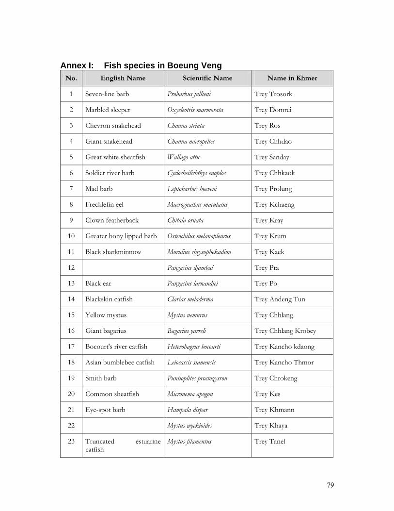
79
Annex I: Fish species in Boeung Veng
No. English Name Scientific Name Name in Khmer
1 Seven-line barb Probarbus jullieni Trey Trosork
2 Marbled sleeper Oxyeleotris marmorata Trey Domrei
3 Chevron snakehead Channa striata Trey Ros
4 Giant snakehead Channa micropeltes Trey Chhdao
5 Great white sheatfish Wallago attu Trey Sanday
6 Soldier river barb Cyclocheilichthys enoplos Trey Chhkaok
7 Mad barb Leptobarbus hoeveni Trey Prolung
8 Frecklefin eel Macrognathus maculatus Trey Kchaeng
9 Clown featherback Chitala ornata Trey Kray
10 Greater bony lipped barb Osteochilus melanopleurus Trey Krum
11 Black sharkminnow Morulius chrysophekadion Trey Kaek
12 Pangasius djambal Trey Pra
13 Black ear Pangasius larnaudiei Trey Po
14 Blackskin catfish Clarias meladerma Trey Andeng Tun
15 Yellow mystus Mystus nemurus Trey Chhlang
16 Giant bagarius Bagarius yarreli Trey Chhlang Krobey
17 Bocourt's river catfish Heterobagrus bocourti Trey Kancho kdaong
18 Asian bumblebee catfish Leiocassis siamensis Trey Kancho Thmor
19 Smith barb Puntioplites proctozysron Trey Chrokeng
20 Common sheatfish Micronema apogon Trey Kes
21 Eye-spot barb Hampala dispar Trey Khmann
22 Mystus wyckioides Trey Khaya
23 Truncated estuarine catfish
Mystus filamentus Trey Tanel

80
24 False black lancer catfish Bagrichthys macropterus Trey Chektum
25 Red tail tinfoil barb Barbodes altus Trey Kahae
26 Cyclocheilichthys repasson Trey Sroka Kdam
27 Osteochilus schlegeli Trey Lolork So
28 Whisker sheatfish Ompok hypophthalmus Trey Ta On
29 Climbing perch Anabas testudineus Trey Kragn
30 Kissing gourami Helostoma temmincki Trey Kantrop
31 Duskyfin glassy perchlet Parambassis wolffi Trey Kantrong Preng
32 Moonlight gourami Trichogaster microlepis Trey Kamphleagn Phluk
33 Threespot gourami Trichogaster trichopterus Trey Kampleagn Samrae
34 Peacock eel Macrognathus siamensis Trey Chhlugn
35 Dangila spilopleura Trey Ach Kok
36 Siamese glassfish Pseudambassis notatus Trey Kagn Chagnchras
37 Chameleon botia Botia beauforti Trey Kagnchruk
38 Wrestling half-beak Dermogenys pusilla Trey Phtong
39 Silver rasbora Rasbora myersi Trey Changva
40 Blue panchax Aplocheilus panchax Trey Changva Ronong
41 Striped flying barb Esomus metallicus Trey Changva Phleang
42 Redeye puffer Carinotetraodon lorteti Trey Kampot
43 Kryptopterus hexapterus Trey Kam Phleav
44 Borneo river sprat Clupeoides borneensis Trey Bandol Ampouv
45 White lady carp Thynnichthys thynnoides Trey Legn
46 Henicorhynchus caudimaculatus Trey Real
47 Bengal mudeel Ophisternon bengalense Antung
48 Brownze featherback Notopterus notopterus Trey Slath
49 Iridescent mystus Mystus multiradiatus Trey Kagn Cho Chhnouth

81
50 Goldfin tinfoil barb Hypsibarbus malcolmi Trey Chhpin
51 Channa lucius Kanthorn Chay
52 Bonylip barb Osteochilus microcephalus Trey Kros Source: Inventory and Management of Cambodian Wetlands Project, Phase I (2001)

82
Annex II: Fish species were caught by local people in Siem Bok
No. Name in Khmer Scientific Name English Name 1 Trey Kol Reang Catlocarpio siamensis Giant barb 2 Trey Tro Sok Probarbus jullieni Seven-line barb 3 Trey Dum Rei Oxyeleotris marmorata Marbled sleeper 4 Trey Ros Channa striata Chevron snakehead 5 Trey Pasi I Mekongina erythrospila 6 Trey Pava Muk Muoy Labeo erythropterus 7 Trey Pava Muk Py
Bangana behri
8 Trey Klang Hay Belodontichthys dinema Twisted jaw sheatfish 9 Trey Romeas Osphronemus exodon Elephant ear gourami 10 Trey Chhdao Channa micropeltes Giant snakehead 11 Trey Sanday Wallago attu Great white sheatfish 12 Trey Chhkaok Cyclocheilichthys enoplos Soldier river barb 13 Trey Prolung Leptobarbus hoeveni Mad barb 14 Trey Pruol Cirrhinus microlepis Small scale mud carp 15 Trey Khchoeng Macrognathus maculatus Frecklefin eel 16 Trey Kray Chitala ornata Clown featherback 17 Trey Krum Osteochilus melanopleurus Greater bony lipped barb 18 Trey Kaek Morulius chrysophekadion Black sharkminnow 19 Trey Pra Pangasius djambal 20 Trey Pou Pangasius larnaudiei Black ear 21 Trey Andeng Tonle Plotosus lineatus 22 Trey Chhlang Mystus nemurus Yellow mystus 23 Trey Kanchu Mystus singaringan 24 Trey Proma Boesemania microlepis Smallscale croaker 25 Trey Pream Eleuthronema tetradactylum Fourfinger threadfin 26 Trey Chro Keng Puntioplites proctozysron Smith barb 27 Trey Kes Micronema apogon Common sheatfish 28 Trey Khmann Hampala dispar Eye-spot barb 29 Trey Khya Mystus wyckioides 30 Trey Tanel Mystus filamentus Truncated estuarine
catfish 31 Trey Chek Tum Bagrichthys macropterus False black lancer catfish 32 Trey Kahe Barbodes altus Red tail tinfoil barb 33 Trey Sroka Kadam Cyclocheilichthys repasson 34 Trey Lolork sor Osteochilus schlegeli 35 Trey Ta On Ompok hypophthalmus Whisker sheatfish 36 Trey Kranh Anabas testudineus Climbing perch 37 Trey KanTrop Helostoma temmincki Kissing gourami 38 Trey Kantrong Preng Parambassis wolffi Duskyfin glassy perchlet 39 Trey Kam Pleanh Plue Trichogaster microlepis Moonlight gourami 40 Trey Ka Uk Arius caelatus Engraved sea catfish 41 Trey Ka Peat Scleropages formosus Malayan bonytongue 42 Trey Ach Kok Dangila spilopleura 43 Trey Kanchanh Chrah Pseudambassis notatus Siamese glassfish 44 Trey Kanchrouk Botia beauforti Chameleon botia

83
45 Trey Ptong Dermogenys pusilla Wrestling half-beak 46 Trey Chang Va Rasbora myersi Silver rasbora 47 Trey Chang Va Ronong Aplocheilus panchax Blue panchax 48 Trey Chang Va Pleang Esomus metallicus Striped flying barb 49 Trey Chang Va Moul Rasbora aurotaenia Pale rasbora 50 Trey Sloek russey Longiculter siahi 51 Trey Chhveat Pangasius macronema 52 Trey Ke Pangasius conchophilus 53 Trey Chhpin Hypsibarbus malcolmi Goldfin tinfoil barb 54 Trey Kros Osteochilus microcephalus Bonylip barb 55 Trey Khla Datnioides microlepis Finescale tigerfish 56 Trey Phka Kor Cirrhinus molitorella Mud carp 57 Trey Amil Tum Systomus orphoides Red cheek barb 58 Trey Kro Mom Ompok bimaculatus Butter catfish 59 Trey Stuok Wallago leeri 60 Trey Bang Kuoy Luciosoma bleekeri 61 Trey Khsan Glossogobius aureus Golden tank goby 62 Trey Krobei Bagarius bagarius Dwarf goonch 63 Trey Kam Pot Carinotetraodon lorteti Redeye puffer 64 Trey Andarth Chhke Typhlachirus elongatus Mekong blind sole 65 Trey Slat Notopterus notopterus Bronze featherback 66 Trey Bobel Amphotistius imbricatus 67 Trey Kambut Chro Mus Amblyrhynchichthys truncatus 68 Trey Linh Thynnichthys thynnoides White lady carp 69 Trey Real Henicorhynchus caudimaculatus 70 Trey Real Ang Kam Henicorhynchus cryptopogon 71 Trey Real Tup Henicorhynchus siamensis
Source: Inventory and Management of Cambodian Wetlands Project, Phase I (2001)
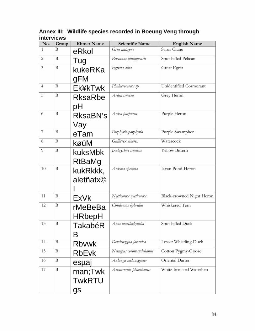
84
Annex III: Wildlife species recorded in Boeung Veng through interviews
No. Group Khmer Name Scientific Name English Name 1 B eRkol Grus antigone Sarus Crane
2 B Tug Pelecanus philippensis Spot-billed Pelican
3 B kukeRKagFM
Egretta alba Great Egret
4 B Ek¥kTwk Phalacrocorax sp Unidentified Cormorant
5 B RksaRbepH
Ardea cinerea Grey Heron
6 B RksaBN’sVay
Ardea purpurea Purple Heron
7 B eTam Porphyrio porphyrio Purple Swamphen
8 B køúM Gallicrex cinerea Watercock
9 B kuksMbkRtBaMg
Ixobrychus sinensis Yellow Bittern
10 B kukRkkk,aletñatx©I
Ardeola speciosa Javan Pond-Heron
11 B ExVk Nycticorax nycticorax Black-crowned Night Heron
12 B rMeBeBaHRbepH
Chlidonias hybridus Whiskered Tern
13 B TakabéRB
Anas poecilorhyncha Spot-billed Duck
14 B Rbvwk Dendrocygna javanica Lesser Whistling-Duck
15 B RbEvk Nettapus coromandelianus Cotton Pygmy-Goose
16 B esµaj Anhinga melanogaster Oriental Darter
17 B man;TwkTwkRTUgs
Amaurornis phoenicurus White-breasted Waterhen
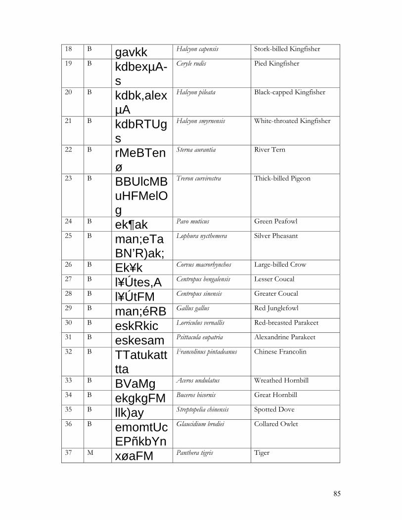
85
18 B gavkk Halcyon capensis Stork-billed Kingfisher
19 B kdbexµA-s
Ceryle rudis Pied Kingfisher
20 B kdbk,alexµA
Halcyon pileata Black-capped Kingfisher
21 B kdbRTUgs
Halcyon smyrnensis White-throated Kingfisher
22 B rMeBTenø
Sterna aurantia River Tern
23 B BBUlcMBuHFMelOg
Treron curvirostra Thick-billed Pigeon
24 B ek¶ak Pavo muticus Green Peafowl
25 B man;eTaBN’R)ak;
Lophura nycthemera Silver Pheasant
26 B Ek¥k Corvus macrorhynchos Large-billed Crow
27 B l¥Útes,A Centropus bengalensis Lesser Coucal
28 B l¥ÚtFM Centropus sinensis Greater Coucal
29 B man;éRB Gallus gallus Red Junglefowl
30 B eskRkic Lorriculus vernallis Red-breasted Parakeet
31 B eskesam Psittacula eupatria Alexandrine Parakeet
32 B TTatukatttta
Francolinus pintadeanus Chinese Francolin
33 B BVaMg Aceros undulatus Wreathed Hornbill
34 B ekgkgFM Buceros bicornis Great Hornbill
35 B llk)ay Streptopelia chinensis Spotted Dove
36 B emomtUcEPñkbYn
Glaucidium brodiei Collared Owlet
37 M xøaFM Panthera tigris Tiger

86
38 M xøaRtI Prionailurus viverrinus Fishing Cat
39 M QøÚs Muntiacus muntjak Red Muntjac
40 M eRbIs Cervus unicolor Sambar
41 M sMeBacRkGUb
Paradoxurus hermaphroditus
Common Palm Civet
42 M sVa Macaca sp Unidentified monkey
43 M RCUkéRB
Sus scrofa Wild Pig
44 M BRgUl Pangolin
45 R GnSg Varanus salvator Giant monitor/Two-banded monitor
46 R RtkYt Varanus nebulosus Monitor lizard
47 R GeNþIk Unidentified Tortoise
48 R kn§ay Unidentified Turtle
49 R Bs;Evk Unidentified Cobra
50 R Bs;føan; Python
51 R Bs;éRB Forest Snake (Khmer Name)
Group: B=Bird, M=Mammal, R=Reptile Source: Inventory and Management of Cambodian Wetlands Project, Phase I (2001)

87
Annex IV: Species of wildlife sold in Stung Treng province No Faunal species Unit Price (Riel) Other
1
Thick-billed Green Pigeon 1 bird 500-800
2
Yellow-footed Pigeon 1 bird 1000-1500
3
Vernal Henging Parrot 1 bird 1000-1500
4
Alexandrine Parakeet 1 bird 15000-25000
5
White-breasted Waterhen 1 bird 500
6
Spotted Dove 1 bird 500-1000
7
Cobra 1 kg 40000-70000
8
Python 1 kg 10000-15000
9
Pangolin 1 kg 100000
10
Giant Monitor/Two-banded Monitor, Varanus salvator
1 kg 7000
11
Monitor Lizard 1 3000
12
Banteng 1 kg 9000 Fresh meat
13 Red Muntjac 1 kg 1 kg 1
2000-3000 10000-12000 20000
Fresh meat sold in the village Fresh meat sold in the market Sold in the village
14 Wild Pig 1 1 kg
35000-60000 2000
Fresh meat sold in the village
15
Hare 1 6000
16
Sambar 1 kg 2000-3000 Fresh meat sold in the village
Source: Inventory and Management of Cambodian Wetlands Project, Phase I (2001)

88
Annex V: Species of Flooded Forest Vegetation in along the Mekong River in Siem Bok
No. Name in Khmer Scientific name Abundance 1 Reang Taek Barringtonia Acutangula Common 2 Rei Taek Homonoia riparia Common 3 Sdey Crudia chrysantha Uncommon 4 Banla Yuon Mimosa pigra Common 5 Cha Butea frondosa Rare 6 Vor Tros Combretum trifoliatum Common 7 Russey Prey Bambusa arundinacea Abundant 8 Phnom Phneng Hymenocardia wallichii Rare 9 Khle Cudrania cambodiana Rare 10 Kabas Prey Croton krabas Rare 11 Kdol Mimusops elengil Uncommon 12 Tun Lea Crataeva religiosa Uncommon 13 Dey Khla Gardenia sp or Angkorensis pitard Rare 14 Thloem Andoek Rare 15 Khtum Stephegyne pavirfolia or Mitragyna brunonis Rare 16 Anh Chanh Gmelina asiatica Rare 17 Tro Sek Rare 18 Tro Num Pro Phem Rare 19 Dang Keap Kdam Antidesma ghaesembilla Rare 20 Kro Bao Hydnocarpus anthelminthica Rare 21 Snay Taek Grewia sinuala Rare
Source: Inventory and Management of Cambodian Wetlands Project, Phase I (2001)

89
Annex VI: Flooded forest species in Boeung Veng, Stung Treng Province
No. Name in Khmer Scientific Name Height (m) Abundance
1 Vor Tros Combretum trifoliatum 5 Common 2 Rang Taek Barringtonia micrantha 5 Medium 3 Thlaem Andoeuk 1.5 Medium 4 Tean Prey Vitex holpadenon 2 Medium 5 Kabas Prey Croton krabas 3 Medium 6 Khlae Cudrania cambodiana 5 Medium 7 Bay Dumnoeup Acacia spiralis 3 Medium 8 Vorpream 3 Medium 9 Chrorkeng Touy 3 Rare 10 Tronum Prophem 2 Medium 11 Gnor Morinda 0.7 Medium 12 Ta Oua Terminalia cambodiana 6 Medium 13 Trorsek 6 Medium 14 Trorseath 6 Rare 15 Sandann Garcinia loureiri 3 Rare 16 Srang 4 Medium 17 Krovann 4 Medium 18 Vor Srortey 4 Medium 19 Kror 5 Rare 20 Krorbao Hydnocarpus saigonensis 2 Rare 21 Phnom Phneng Hymenocardia wallichii 3 Medium 22 Snoul Taek 2 Medium 23 Thmegn Trey Bridelia cambodiana 3 Medium 24 Phnek Preap Breynia rhamnoides 3 Medium 25 Dey Khla Gardenia sp 2.5 Rare 26 Sdey Crudia chrysantha 4 Uncommon 27 Khtum Stephegyne pavirfolia 3 Uncommon 28 Leach Phtus Fluggea microcarpa 2 Uncommon 29 Russey Prey Bambusa arundinacea 2.5 Uncommon 30 Banla Youn Mimosa pigra 2.5 Uncommon 31 Cha Butea frondosa 5 Rare 32 Trorbek Prey 4 Medium
Source: Inventory and Management of Cambodian Wetlands Project, Phase I (2001)

90
Annex VII: Important Wetland Sites in Cambodia
No. Wetland Site Location Coordinates Area (ha)
Mar
sh
Riv
er/ C
reek
Lake
Floo
ded
Fore
st
Ric
e Fi
eld
Lotu
s Fi
eld
Stre
am
1 Stung Treng Mekong River Flooded Forest Stung Treng Provincial Town
13o 11' 50" - 13o 56' 00" N 105o 52' 00" - 106o 03' 50" E 48,000 X X X
2 Tonle Sekong River System Stung Treng
13o 31' 00" - 14o 28' 00" N 105o 57' 30" - 106o 26' 00" E 34,750 X X
3 Tonle Sesan River System 35 km from Ratanakiri Provincial Town
13o 32' 00" - 14o 06' 00" N 105o 58' 00" - 107o 27' 50" E 146,250 X
4 Tonle Sre Pork River System
30 km from Ratanakiri Provincial Town in the South
13o 01' 15" - 13o 33' 20" N 106o 17' 30" - 107o 30' 00" E 157,500 X X X X
5 Kratie River System Kratie
12o 08' 35" - 13o 12' 00" N 105o 28' 50" - 106o 09' 00" E 142,250 X X X
6 Peam Chileang Mekong River System
10 km from Kampong Cham Provincial Town in the N-E
12o 00' 00" - 12o 18' 30" N 105o 28' 50" - 105o 52' 00" E 63,750 X X X
7 Siem Bok Mekong River System Kampong Cham
11o 50' 10" - 12o 00' 00" N 105o 02' 00" - 105o 29' 00" E
8 Boeung Veal Sam Nap 10 km in the North-East of Phnom Penh
11o 33' 17" - 11o 38' 25" N 105o 00' 15" - 105o 06' 00" E 10,850 X X X
9 Boeung Prang 11 km in the North-East of Phnom Penh
11o 32' 00" - 11o 45' 25" N 105o 07' 00" - 105o 15' 00" E 12,600 X X X X
Source: Cambodian Wetland Overview and Identification Report (1997)

91
No. Wetland Site Location Coordinates Area (ha)
Mar
sh
Riv
er/ C
reek
Lake
Floo
ded
Fore
st
Ric
e Fi
eld
Lotu
s Fi
eld
Stre
am
10 Boeung Pring Prey Veng Province about 30 km from Neak Loeung
11o 22' 15" - 11o 29' 27" N 105o 23' 00" - 105o 26' 15" E 16,000 X X X
11 Boeung Khsach Sor Prey Veng
11o 23' 00" - 11o 22' 15" N 105o 19' 17" - 105o 23' 28" E X X X
12 Upper Stung Sen Creek System
55 km in the South-West of Preah Vihea Province
13o 48' 00" - 14o 13' 00" N 104o 32' 20" - 104o 58' 30" E 80,000 X X X
13 Prek Toal Battambang
12o 59' 00" - 13o 20' 30" N 103o 26' 30" - 103o 43' 25" E X X X X
14 Moat Peam 15 km in the South of Siem Reap Provincial Town
13o 03' 00" - 13o 19' 00" N 103o 43' 00" - 104o 12' 00" E 45,000 X X X X
15 Stung Daun Try 60 km from Pursat Provincial Town in the North-East
12o 44' 00" - 13o 00' 00" N 103o 37' 00" - 103o 53' 00" E 103,000 X X X X X
16 Pursat Great Lake System 25 km in the North of Pursat Provincial Town
12o 28' 00" - 12o 51' 00" N 103o 52' 30" - 104o 23' 35" E 55,000 X X X X
17 Moat Khla Siem Reap
12o 44' 15" - 13o 04' 00" N 103o 08' 00" - 104o 15' 00" E 45,000 X X X X
18 Boeung Chhmar Kampong Thom
12o 44' 25" - 12o 55' 20" N 104o 15' 10" - 104o 22' 00" E 33,000 X X X X X
19 Lower Stung Sen 15 km in the West of Kampong Thom Town
12o 31' 50" - 12o 49' 00" N 104o 27' 40" - 104o 47' 00" E 61,200 X X X X X
Source: Cambodian Wetland Overview and Identification Report (1997)

92
No. Wetland Site Location Coordinates Area (ha)
Mar
sh
Riv
er/ C
reek
Lake
Floo
ded
Fore
st
Ric
e Fi
eld
Lotu
s Fi
eld
Stre
am
20 Boeung Veal Pork 10 km from Kampong Chhnang Provincial Town
12o 17' 00" - 12o 32' 00" N 104o 02' 00" - 104o 45' 00" E 56,500 X X X X X
21 Boeung Thom
About 5 km in the last of Kampong Chhnang Provincial Town
12o 09' 00" - 12o 31' 10" N 104o 42' 00" - 104o 59' 00" E 72,500 X X X X X
22 Boeung Sam Rong Kandal
11o 39' 10" - 11o 42' 00" N 104o 46' 20" - 104o 48' 10" E X X X X X
23 Boeung Ta Mouk Kandal
11o 37' 00" - 11o 40' 00" N 104o 46' 25" - 104o 48' 20" E X X X X X
24 Prasat Tuyav Lake
South=East of Phnom Penh about 57 km (Kandal Province)
11o 07' 00" - 11o 12' 20" N 105o 05' 27" - 105o 10' 00" E 72,000 X X X X X
Source: Cambodian Wetland Overview and Identification Report (1997)

93
Freshwater Wetland Sites This type of wetland includes the central reaches and floodplain of the Mekong River, Tonle Sap Lake (Great Lake) and associated lakes, tributaries and creek systems. There are 21 main sites through out Cambodia:
1) Boeung Pring flooded forest Coordinates: 11o 14' 30" – 11o 31' 00" N 103o 17' 00" – 105o 27' 30" E Location: About 30 km NE of Neak Loeung District Town, Prey Veng
Province. Total Area: 16,000 ha - Water surface: 6,000 ha - Marshes: 10,000 ha Altitude: Average: 6.3 m Maximum: 8 m Wetland Types: Lakes, flooded forest, marshes Soil Types: Brown alluvial and cultural hydromorphic
2) Kratie River system and marshes
Coordinates: 12o 06' 00" – 13o 14' 00" N 105o 42' 00" – 106o 10' 00" E Location: Part of the Mekong River, Kratie Province. Total Area: 142,250 ha - Water surface: 55,000 ha - Marshes: 87,250 ha Altitude: Average: 56 m Maximum: 63 m Wetland Types: River creek system, flooded forest and rice fields
3) Tonle Sekong river system
Coordinates: 13o 31' 00" – 14o 28' 00" N 105o 57' 30" – 106o 27' 00" E Location: About 10 km NE of Stung Treng town, Stung Treng Province. Total Area: 34,750 ha - Water surface: 16,250 ha - Marshes: 18,500 ha Altitude: Average: 53.14 m Maximum: 62 m Wetland Types: River system and flooded forest Soil Types: Grey hydromorphic, acid lithosol and browm alluvial.
4) Tonle Sre Pork creek system
Coordinates: 12o 56' 00" – 13o 34' 00" N 106o 17' 10" – 107o 31' 00" E Location: About 10 km S of Ratanakiri Provincial town, Ratanakiri
Province. Total Area: 157,500 ha - Water surface: 14,875 ha - Marshes: 142,625 ha Altitude: Average: 130 m

94
Maximum: 203 m Wetland Types: Creek system, marshes and flooded forest Soil Types: Acid lithosol, Brown alluvial and plinthite podzol
5) Tonle Se San creek system
Coordinates: 13o 29' 00" – 14o 10' 00" N 106o 05' 00" – 107o 26' 00" E Location: About 35 km from Ratanakiri Provincial town, SW of Virachey
National Park, Ratanakiri Province. Total Area: 146,250 ha - Water surface: 16,750 ha - Marshes: 129,500 ha Altitude: Average: 54 m Maximum: 63 m Wetland Types: Streams, flooded forest and marshes. Soil Types: Acid lithosol, grey hydromorphic, and red-yellow podzol.
6) Stung Treng Mekong River flooded forest
Coordinates: 13o 12' 00" – 13o 56' 00" N 105o 51' 00" – 106o 04' 00" E Location: Along the Mekong River, N and S of Stung Treng Provincial
town, Stung Treng Province. Total Area: 48,000 ha - Water surface: 33,000 ha - Marshes: 15,000 ha Altitude: Average: 49.33 m Maximum: 62 m Wetland Types: River system, flooded forest and agriculture. Soil Types: Acid lithosol and grey hydromorphic. Note: This area is one of the Ramsar sites in the country.
7) Tonle Sap creek system
Coordinates: 12o 00' 00" – 12o 20' 00" N 105o 26' 10" – 105o 42' 00" E Location: About 10 km NE of Kampong Cham Provincial town,
Kampong Cham Province. Total Area: 63,750 ha - Water surface: 7,500 ha - Marshes: 56,250 ha Altitude: Average: 9.1 m Maximum: 15 m Wetland Types: Lakes, creek system and marshes. Soil Types: Brown alluvial and ragur.
8) Prasat Tuyo lakes, flooded forest and marshes
Coordinates: 11o 03' 30" – 11o 27' 30" N 105o 00' 00" – 105o 16' 30" E Location: About 57 km E of Phnom Penh. Total Area: 72,000 ha - Water surface: 7,000 ha

95
- Marshes: 65,000 ha Altitude: Average: 7 m Maximum: 10 m Wetland Types: Lakes, flooded forest, marshes, rice fields and ponds. Soil Types: Brown alluvial.
9) Boeung Veal Samnap
Coordinates: 11o 31' 45" – 11o 39' 00" N 105o 00' 15" – 105o 07' 30" E Location: About 10 km NE of Phnom Penh. Total Area: 10,850 ha - Water surface: 2,800 ha - Marshes: 8,050 ha Altitude: Average: 9 m Maximum: 12 m Wetland Types: Lake4s, flooded forest and marshes. Soil Types: Clay and alluvial.
10) Boeung Prang lowland rice fields
Coordinates: 11o 31' 15" – 11o 39' 00" N 105o 06' 40" – 105o 13' 45" E Location: 11 km NE of Phnom Penh. Total Area: 12,600 ha - Water surface: 1,700 ha - Marshes: 10,900 ha Altitude: Average: 6 m Maximum: 9 m Wetland Types: Lakes, flooded forest, rice fields and marshes. Soil Types: Clay and alluvial.
11) O Chang Rung lake and flooded forest
Coordinates: 12o 33' 30" – 12o 50' 00" N 103o 54' 00" – 104o 13' 00" E Location: About 25 km N of Pursat Provincial town, Pursat Province. Total Area: 55,000 ha - Water surface: 11,500 ha - Marshes: 43,500 ha Altitude: Average: 15.3 m Maximum: 20 m Wetland Types: Lakes, flooded forest, marshes and rice fields. Soil Types: Grey hydromorphic, and mud.
12) Upper Stung Sen creek system and marshes
Coordinates: 13o 48' 00" – 14o 12' 00" N 104o 32' 00" – 106o 59' 00" E Location: About 55 km SW of Preah Vihear Provincial town. Total Area: 80,000 ha - Water surface: 10,000 ha - Marshes: 70,000 ha Altitude: Average: 80.9 m
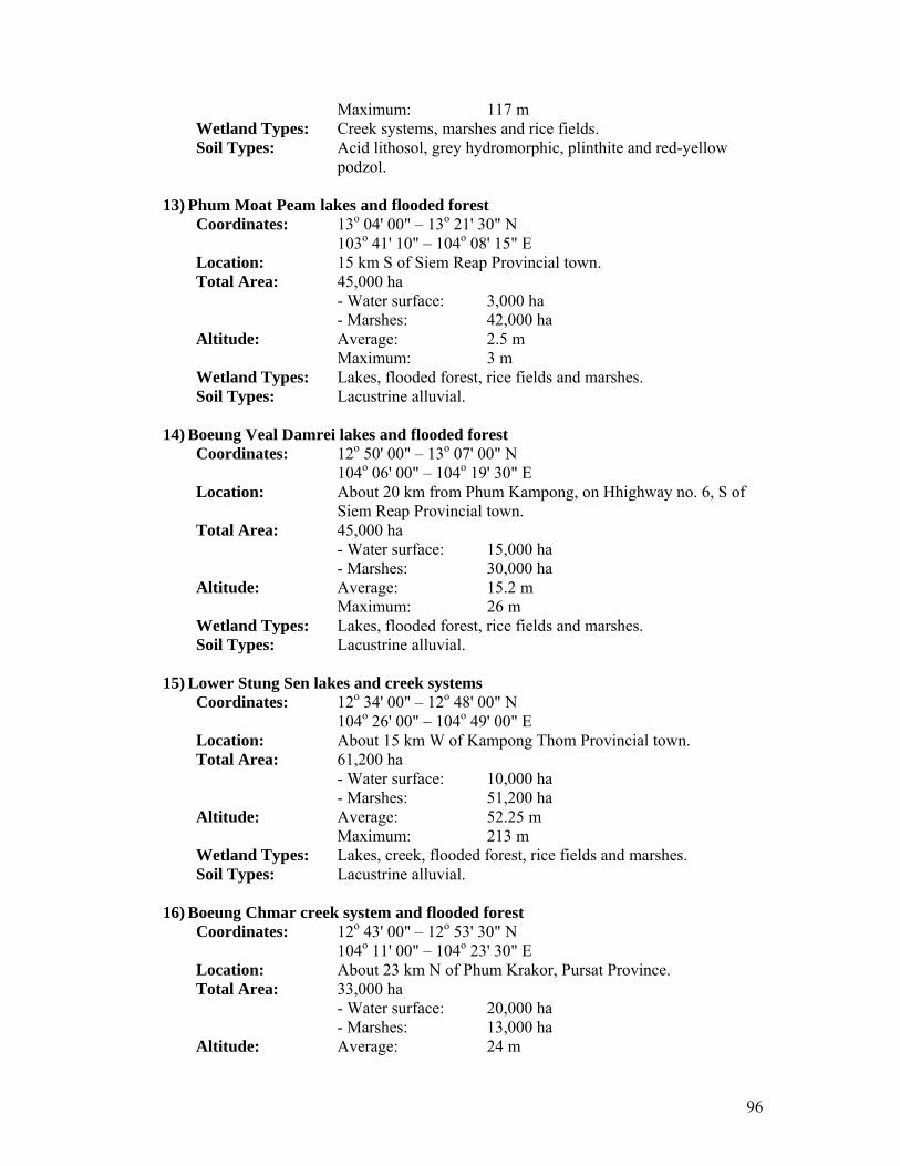
96
Maximum: 117 m Wetland Types: Creek systems, marshes and rice fields. Soil Types: Acid lithosol, grey hydromorphic, plinthite and red-yellow
podzol.
13) Phum Moat Peam lakes and flooded forest Coordinates: 13o 04' 00" – 13o 21' 30" N 103o 41' 10" – 104o 08' 15" E Location: 15 km S of Siem Reap Provincial town. Total Area: 45,000 ha - Water surface: 3,000 ha - Marshes: 42,000 ha Altitude: Average: 2.5 m Maximum: 3 m Wetland Types: Lakes, flooded forest, rice fields and marshes. Soil Types: Lacustrine alluvial.
14) Boeung Veal Damrei lakes and flooded forest
Coordinates: 12o 50' 00" – 13o 07' 00" N 104o 06' 00" – 104o 19' 30" E Location: About 20 km from Phum Kampong, on Hhighway no. 6, S of
Siem Reap Provincial town. Total Area: 45,000 ha - Water surface: 15,000 ha - Marshes: 30,000 ha Altitude: Average: 15.2 m Maximum: 26 m Wetland Types: Lakes, flooded forest, rice fields and marshes. Soil Types: Lacustrine alluvial.
15) Lower Stung Sen lakes and creek systems
Coordinates: 12o 34' 00" – 12o 48' 00" N 104o 26' 00" – 104o 49' 00" E Location: About 15 km W of Kampong Thom Provincial town. Total Area: 61,200 ha - Water surface: 10,000 ha - Marshes: 51,200 ha Altitude: Average: 52.25 m Maximum: 213 m Wetland Types: Lakes, creek, flooded forest, rice fields and marshes. Soil Types: Lacustrine alluvial.
16) Boeung Chmar creek system and flooded forest
Coordinates: 12o 43' 00" – 12o 53' 30" N 104o 11' 00" – 104o 23' 30" E Location: About 23 km N of Phum Krakor, Pursat Province. Total Area: 33,000 ha - Water surface: 20,000 ha - Marshes: 13,000 ha Altitude: Average: 24 m

97
Maximum: 59 m Wetland Types: Lakes, creek, flooded forest, rice fields and marshes. Soil Types: Lacustrine alluvial.
17) Boeung Veap Pok lakes, river system and flooded forest
Coordinates: 12o 19' 00" – 12o 36' 00" N 104o 30' 00" – 104o 45' 00" E Location: 10 km from Kampong Chhnang Provincial town. Total Area: 56,500 ha - Water surface: 20,000 ha - Marshes: 36,000 ha Altitude: Average: 198 m Maximum: 545 m Wetland Types: Lakes, creek, flooded forest, rice fields and marshes. Soil Types: Acid lithosol and lacustrine alluvial.
18) Boeung Thom lakes, river system and flooded forest
Coordinates: 12o 07' 00" – 12o 34' 00" N 104o 41' 00" – 105o 07' 00" E Location: About 5 km E of Kampong Chhnang Provincial town. Total Area: 72,500 ha - Water surface: 35,000 ha - Marshes: 37,500 ha Altitude: Average: 20.7 m Maximum: 26 m Wetland Types: Lakes, river system, flooded forest, rice fields and marshes. Soil Types: Lacustrine alluvial and panol.
19) Stung Daun Try flooded forest, rivers and lakes
Coordinates: 12o 44' 30" – 13o 06' 00" N 103o 31' 40" – 103o 58' 00" E Location: 60 km NE of Pursat Provincial town. Total Area: 103,000 ha - Water surface: 11,200 ha - Marshes: 91,800 ha Altitude: Average: 19 m Maximum: 52 m Wetland Types: Flooded forest, rivers, lakes, marshes and rice fields. Soil Types: Alluvial and mud.
20) Stung Sangke flooded forest, streams and lakes
Coordinates: 13o 12' 30" – 13o 20' 00" N 103o 34' 00" – 103o 45' 00" E Location: About 40 km NE of Battabang Provincial town. Total Area: 22,000 ha - Water surface: 6,000 ha - Marshes: 16,000 ha Altitude: Average: 3.5 m Maximum: 5 m Wetland Types: Flooded forest, streams, lakes and marshes.

98
Soil Types: Alluvial, clay and mud.
Brackish Water Wetland Sites These types of wetlands are located on the coastal plain and all liked to the sea. The water component seasonally changes into brackish during rainy season and saline during dry season. The main vegetation types in these wetlands are mangroves and rear mangroves, which support reptiles, small mammals and aquatic species. There are two brackish wetland sites.
1) Stung Metoek mangrove and creek system Coordinates: 11o 32' 00" – 11o 51' 00" N 102o 51' 00" – 103o 06' 00" E Location: About 1 km N of Koh Kong Provincial town. Total Area: 22,500 ha - Water surface: 10,000 ha - Marshes: 12,500 ha Altitude: Average: 116.6 m Maximum: 153 m Wetland Types: Mangrove, creek systems, rear mangrove and shrimp ponds. Soil Types: Coastal complex.
2) Prek Piphot creek system and swamp mangroves
Coordinates: 11o 04' 30" – 11o 19' 00" N 103o 18' 30" – 103o 36' 30" E Location: 10 km N of Sre Ambel, Koh Kong Province. Total Area: 21,250 ha - Water surface: 12,750 ha - Marshes: 85,000 ha Altitude: Average: 62 m Maximum: 262 m Wetland Types: Mangrove, creek systems, mud, sand and a little rear mangrove. Soil Types: Acid lithosol and alumisol.
Marine Wetland Sites Marine wetlands are located in coastal areas similar to the brackish wetlands; however the water regime is permanent although the water table can move with the start of the rainy season. Six sites have been identified as internationally important habitats for migratory birds or marine aquatic species.
1) Kampong Trach marshes and salt ponds Coordinates: 10o 24' 30" – 10o 33' 30" N 104o 24' 00" – 104o 36' 00" E Location: About 2 km E of Kep town. Total Area: 7,500 ha - Water surface: 2,500 ha - Marshes: 15,000 ha Altitude: Average: 89.7 m Maximum: 144 m
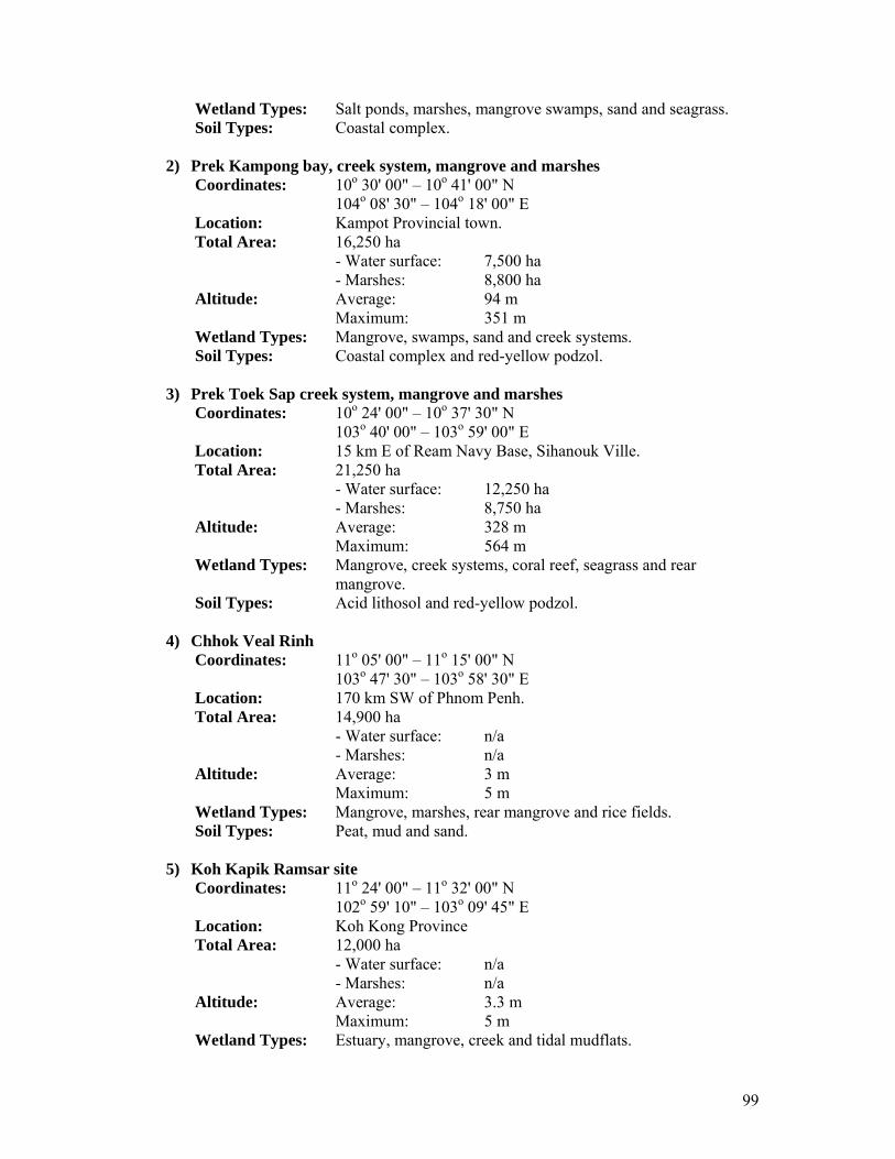
99
Wetland Types: Salt ponds, marshes, mangrove swamps, sand and seagrass. Soil Types: Coastal complex.
2) Prek Kampong bay, creek system, mangrove and marshes
Coordinates: 10o 30' 00" – 10o 41' 00" N 104o 08' 30" – 104o 18' 00" E Location: Kampot Provincial town. Total Area: 16,250 ha - Water surface: 7,500 ha - Marshes: 8,800 ha Altitude: Average: 94 m Maximum: 351 m Wetland Types: Mangrove, swamps, sand and creek systems. Soil Types: Coastal complex and red-yellow podzol.
3) Prek Toek Sap creek system, mangrove and marshes
Coordinates: 10o 24' 00" – 10o 37' 30" N 103o 40' 00" – 103o 59' 00" E Location: 15 km E of Ream Navy Base, Sihanouk Ville. Total Area: 21,250 ha - Water surface: 12,250 ha - Marshes: 8,750 ha Altitude: Average: 328 m Maximum: 564 m Wetland Types: Mangrove, creek systems, coral reef, seagrass and rear
mangrove. Soil Types: Acid lithosol and red-yellow podzol.
4) Chhok Veal Rinh
Coordinates: 11o 05' 00" – 11o 15' 00" N 103o 47' 30" – 103o 58' 30" E Location: 170 km SW of Phnom Penh. Total Area: 14,900 ha - Water surface: n/a - Marshes: n/a Altitude: Average: 3 m Maximum: 5 m Wetland Types: Mangrove, marshes, rear mangrove and rice fields. Soil Types: Peat, mud and sand.
5) Koh Kapik Ramsar site
Coordinates: 11o 24' 00" – 11o 32' 00" N 102o 59' 10" – 103o 09' 45" E Location: Koh Kong Province Total Area: 12,000 ha - Water surface: n/a - Marshes: n/a Altitude: Average: 3.3 m Maximum: 5 m Wetland Types: Estuary, mangrove, creek and tidal mudflats.

100
Soil Types: Mud, sand and peat.
6) Prek Kampong Som mangrove, swamp and marshes Coordinates: 11o 01' 30" – 11o 09' 00" N 103o 37' 30" – 103o 45' 15" E Location: About 52.5 km N of Sihanouk Ville. Total Area: 10,800 ha - Water surface: 3,300 ha - Marshes: 7,500 ha Altitude: Average: 2.5 m Maximum: 10 m Wetland Types: Mangrove, swamps, marshes and rice fields. Soil Types: Mud, sand and brown soil.