revitalization of urban spine- pan city proposal for vadodara · proposal for commercial...
TRANSCRIPT

GRD Journals | Global Research and Development Journal for Engineering | Recent Advances in Civil Engineering for Global Sustainability | March 2016
e-ISSN: 2455-5703
All rights reserved by www.grdjournals.com 580
Revitalization of Urban Spine- Pan City Proposal
for Vadodara
1Dhruvita.D. Zala 2Dr. K. A. Chauhan 3Dr. J.E.M. Macwan 1M. Tech Student 2Associate Professor & Section Head (Urban Planning) 3Professor & Head of Department
1,2,3Department of Civil Engineering 1,2,3SVNIT, Surat, Gujarat, India
Abstract
Vadodara has secured its name in the list of 100 Smart cities under the Smart City Mission of Ministry of Urban Development
(MoUD), Government of India launched in June 2015. Sustainable and Smart city aims at long term high tech solutions. Cities
have turned into concrete jungles due to advent of machines and over population. Vishwamitri river has acted as an urban spine
to the city even though it’s not a perennial as it divides it geographically into eastern and western region. While the river under
design consideration i.e VMC area is 16.5 kms. The average width of the river is 500m while its depth is 8-10 mt. The 25km stretch
of river passing through the city is the only river in the country having 206 crocodiles living in the urban context. A socio- economic
survey was conducted for deriving the design proposal which included 25% of stake holders including ages , workers, slum
dewellers , 50% of experts including VUDA and VMC officers. The rest 25% included the college and institute heads and faculty
opinions. Even a movie is made showering the existing profile of the river. The state has cleared 66-acre plot for developing the
crocodile park and a garden to boost the natural ecological balance and sustainable tourism. This paper envisages the Development
to create a ‘Cleaner, sustainable, diverse and integrated’ river front for Vadodara to add flavor to the dead urban dense fabric.
The river has become largely inaccessible from the city, and is no longer seen as an asset even though it has got potential to generate
employment, education, recreation, business and provide inclusive growth. The first initiative will be to map the existing land use
and propose the barrages to check the flow and accessibility of water for a sustainable development against seasonal flooding.
Proposal for commercial development in the form of ratri bazaar, crafts centre, exhibition grounds, sports ground can add to the
revenue for financial sustainability. The design proposal will provide new public spaces, heritage walk ways, botanical gardens,
crocodile parks, exhibition grounds, promenades, footpaths and ghats along the riverbanks to add to the environmental and cultural
sustainability. To promote walkability and cycle friendly environment larger blocks are broken into smaller ones. Paper focuses
onto bringing a holistic urban innovation for the people of Vadodara. It will also talk about the volumetric guidelines, svp (special
purpose vehicles), boosting of the recreational, commercial and green land use for a better sustainable futuristic urban planning.
Keyword- Volumetric guidelines, Svps (special purpose vehicles), Promenades, Heritage walk way, Walkable Cities,
Swach Bharat Abhiyan __________________________________________________________________________________________________
I. INTRODUCTION
The proposal for ‘Resurging The Urban Spine of Vadodara City – Pan Project Proposal’ aims to investigate the current role and
situation of urban spine and to develop design strategies in context of landscape architecture and urban design. Designing tool
involves thriving spaces that invite people to linger and, interact and connect. They support the popularity of activity centre’s
providing a space for a wide range of formal and informal activities that supports social and cultural life for users of the centre. As
Vadodara is devoid of recreational spots and places, those which are there in the city itself are in unorganized and underdeveloped
condition so due to this people find their recreational spots outside or moved to other zone which causes heavy traffic congestion
and trip generation. As Vadodara is devoid of recreational spots and places, those which are there in the city itself are in unorganized
and underdeveloped condition so due to this people find their recreational spots outside or moved to other zone which causes heavy
traffic congestion and trip generation. Vadodara city has a potential to develop as a focal point for recreational activities with
various garden, shopping areas. Whole riverfront stretch and many places of public attraction etc. This planning proposal for
rejuvenation involves designing strategies to regenerate recreational spaces which are already existed in city. It starts with
identifying pockets for development with respect to the people visited and by taking destination survey about pros and cons of
recreational spots and suggestions regarding the facilities which needs to be modify. Proposal involves identified pockets individual
drawing and the connected recreational transport circuit network so that all recreational spaces should be interconnected to each
other To rejuvenate the urban spine so that people will be benefited by providing ambiguous environment and added advantage to
the aesthetic beauty of the city.
Revitalization of Urban Spine- Pan City Proposal for Vadodara (GRDJE / CONFERENCE / RACEGS-2016 / 106)
581 All rights reserved by www.grdjournals.com
II. OBJECTIVE AND SCOPE OF STUDY
To study the concept of resurging of urban spine in Indian context.
To identify the potential space for resurging the urban spine of Vadodara city.
To analyze demand and need of the residents for proposals.
To rank the locations on basis of their existing condition.
To provide a suitable planning proposal to resurge the urban spine of Vadodara city considering the future scope.
A. Scope of Study
Physical boundary is limited VMC (Vadodara municipal corporation area).
Limited to proposal of land use plan, rejuvenating & recreational spaces in the form of lake front, streetscape, garden, arts and
craft zone, crocodile park, riverfront and places of public attraction.
Financial aspects are out of scope.
B. Need of Study
Recreational spaces in Vadodara city are devoid in aesthetics and proper facilities, so people found their places of interest
outside the zone or else to other commercial spaces.
This crowd in search of recreational open public space for rest and relaxation, food etc results in more trips and heavy traffic
congestion.
Vishwamitri River has been an important part of Vadodara.
Garbage is dumped in the river, sewage flows from the storm water outfalls, sewage flows through the tributaries, slums have
encroached in to the river and cities have turned back onto the river.
The lag in interconnectivity between the recreational spaces needs to be modify.
Since the river is highly inaccessible, it has lost its cultural significance and therefore has been neglected and abused over
the years.
An unused land like the whole riverfront stretch needs to be revitalized in accordance with the existing places of public
attraction for proper functioning of city.
III. STUDY AREA PROFILE
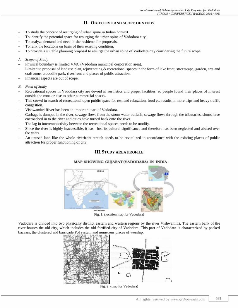
Fig. 1: (location map for Vadodara)
Vadodara is divided into two physically distinct eastern and western regions by the river Vishwamitri. The eastern bank of the
river houses the old city, which includes the old fortified city of Vadodara. This part of Vadodara is characterized by packed
bazaars, the clustered and barricade Pol system and numerous places of worship.
Fig. 2: (map for Vadodara)

Revitalization of Urban Spine- Pan City Proposal for Vadodara (GRDJE / CONFERENCE / RACEGS-2016 / 106)
582 All rights reserved by www.grdjournals.com
Source: Baroda, Gujarat & Bombay states surveyed 1876-77
Vadodara is located at 22.30°N 73.19°E in western India at an elevation of 39 metres (128 ft). It is the 18th largest city in
India with an area of 235 square kilometres (91 sq mi) and a population of 4.1 million according to the 2010–11 census. The city
sits on the banks of the Vishwamitri River, in central Gujarat. The Vishwamitri frequently dries up in the summer, leaving only a
small stream of water. The city is located on the fertile plain between the Mahi and Narmada Rivers. According to the Bureau of
Indian Standards, the town falls under seismic zone-III, in a scale of I to V (in order of increasing proneness to
earthquakes).Vadodara features a tropical savanna climate under Köppen's Climate classification. There are three main seasons:
Summer, Monsoon and Winter. Aside from the monsoon season, the climate is dry.
Fig. 3: (Project influence zone)
Fig. 4: (Evolution of Vadodara City)

Revitalization of Urban Spine- Pan City Proposal for Vadodara (GRDJE / CONFERENCE / RACEGS-2016 / 106)
583 All rights reserved by www.grdjournals.com
IV. METHODOLOGY
The methodology adopted for the study and the sequence of various steps undertaken is shown in the fig below. The first stage is
selection of the study area with aim, objectives. In second stage literature review has been done. Third stage followed by collection
of inventory and field data. Fourth stage consists of analysis and calculation for future requirements. In fifth stage proposals has
been given in various locations to enhance the city development.
Fig. 5: Flow diagram of methodology: author
V. DATA COLLECTION AND ANALYSIS
The Inventory data is collected from different sources like Vadodara Urban Development authority, Vadodara Municipal
Corporation, internet, media and newspapers and the field data are collected from visitors, Experts and Stakeholders.
A. Primary Data Collection
Research papers and journals
Internet and local news channels
newspaper and magazine
Government websites and documents
Case studies and attending seminars, census.
Data from organizations and agencies
B. Secondary Data Collection
Socio economic surveys and physical surveys, interviews and direct observations.
Meetings with subject experts like architects, town planners
Various departments of Vmc& Vuda, local residents and institutions, slums, environmentalist
Made a documentary film and photography
Meetings with Government officials
SWOT analysis is developed following an integrative procedural model that includes the visitors, stakeholders, and experts.

Revitalization of Urban Spine- Pan City Proposal for Vadodara (GRDJE / CONFERENCE / RACEGS-2016 / 106)
584 All rights reserved by www.grdjournals.com
Fig. 6: Data collection procedure: author
C. Analysis
The analysis gives a complete understanding to identify behaviours of visitors, stakeholders and experts for existing situation of
vishwamitri in vaodara city which is followed by comparative analysis, sentimental analysis, gap analysis and SWOT analysis.
D. Preference Analysis
Out of all the surveys conducted 30% of them were college going students youth, then 15% were business class people and 15%
school going kids, 15% working class people while the rest includes retired, home makers and self-employed.
Fig. 7: Data analysis: author
These are the preference for amenities based on the age group.
Fig. 7: Data analysis: author

Revitalization of Urban Spine- Pan City Proposal for Vadodara (GRDJE / CONFERENCE / RACEGS-2016 / 106)
585 All rights reserved by www.grdjournals.com
E. Comparative Analysis
Fig. 8: data analysis: author
Entertainment Elements PREFERENCE 1
MIG
PREFERENCE 2
LOWER INCOME
PREFERENE 3
LIG
PREFERENCE 4
HMIG
PREFERENCE5
HIG
River Based Activities 39 30 11 6 10
Children Park 18 13 38 17 14
Crocodile Park 2 11 18 40 29
Heritage park 40 32 9 7 12
Art & Culture Gallery 1 0 24 30 45
Table 1: Showing The Preferences of Activities According to The Income Group
The comparison between different amenities is shown and it clearly shows residents are mostly wanting to develop with
the heritage, crocodile park and water front.
Fig. 9: data analysis: author
Facilities to be upgraded: Maximum people felt that all the infrastructures are very important and a special consideration aand
care should be taken care while the river front is developed.
F. Gap Analysis
The gap analysis is done on the basis of standard norms considering current scenario for up-gradation of recreational land use for
future development in Vadodara City.
Year Percentage of
Recreational Minimum Requirement of Percentage Gap(N-M)
2011 12.54 15 2.54
Table 2: Gap analysis: author Where,
P = Recreational facilities gap.
M = Existing Recreational
N =Required Recreational facilities
Based on Urban and Regional development plans Formulation and Implementation URDPFI Norms India 2015 for a port
city the recreation area can be minimum 15 to 20 percent of the total land use of the city

Revitalization of Urban Spine- Pan City Proposal for Vadodara (GRDJE / CONFERENCE / RACEGS-2016 / 106)
586 All rights reserved by www.grdjournals.com
G. Attraction Feature
Fig. 10: data analysis: author
The chart shows that maximum attraction for the residents and the out siders lies in the heritage (35%) and culture (25%)
of the city. Thus by the survey strong need for strengthening the heritage should be proposed.
Fig. 11: data analysis: author
Maximum people i.e (35%) people surveyed are having two and four wheelers which contribute largely to the traffic
problem and only 5% are such who have no vehicles which include outsiders, students and slum people.
H. Swot Analysis
1) Strength
Vishwamitri River has great historic and cultural significance in the context of the city.
It is an ecological corridor, a living river.
The river runs through the heart of the city and has several public institutions on its banks.
The character along the river is varied and distinct.
The river has a meandering course which has given rise to several ox bow lakes which are an important environmental asset.
2) Weakness
Over the years the river has become inaccessible, neglected and abused.
Garbage is dumped in the river.
Sewage flows into the river from storm water outfalls and natural drains.
Areas surrounding the river face flood risks every year.
Slums have encroached on the river bank which do not
3) Opportunities
The historic and cultural aspects of the river can be revitalized and given new meaning.
Revitalization of Urban Spine- Pan City Proposal for Vadodara (GRDJE / CONFERENCE / RACEGS-2016 / 106)
587 All rights reserved by www.grdjournals.com
The natural ecology and river system can be preserved and revived to transform an important natural feature into an asset for
the city.
Existing cultural district can be strengthened and new one can be created along the riverfront.
Existing commercial district can be redeveloped and transformed as the new central business district of the city.
Northern and southern stretches of the river are relatively undeveloped and can provide many opportunities for growth and
development.
4) Threats
Flood management and mitigation is required so that areas surrounding the riverfront may be developed and habitable.
Pollution in the river needs to be curbed and diverted so that the natural ecological system is restored.
Crocodiles in the river need to be moved to a dedicated habitat for public safety.
In the central portion the city has already developed upto the edge of the river and the vision for the riverfront will need to
take this into consideration
VI. PLANNING PROPOSAL
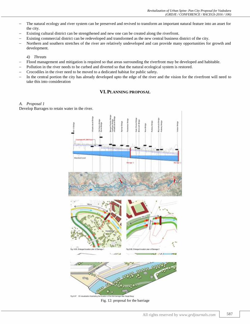
A. Proposal 1
Develop Barrages to retain water in the river.
Fig. 12: proposal for the barriage

Revitalization of Urban Spine- Pan City Proposal for Vadodara (GRDJE / CONFERENCE / RACEGS-2016 / 106)
588 All rights reserved by www.grdjournals.com
Fig. 13: proposal for developing a barriage
B. Proposal 2
Suggesting a sewage treatment plant.
Fig. 14: proposal for the sewage treatment plant
C. Proposal 3- Designing of The SAMA Lake Front
Fig. 15: SAMA talav location - google earth

Revitalization of Urban Spine- Pan City Proposal for Vadodara (GRDJE / CONFERENCE / RACEGS-2016 / 106)
589 All rights reserved by www.grdjournals.com
Fig. 16: conceptual diagram for developing sama talav
Fig. 16.1: Uniform embankments

Revitalization of Urban Spine- Pan City Proposal for Vadodara (GRDJE / CONFERENCE / RACEGS-2016 / 106)
590 All rights reserved by www.grdjournals.com
With the growing threat to pollution and encroachments, conserving the lake as an urban asset of the city is important
1) Recommendations
A comprehensive strategy for development of the lake should be formulated that addresses the needs of the local area and the wider
context. This is necessary to ensure that the project is successful in the long run.
2) Improve accessibility
Create new accesses to the lakefront in order to integrate the master plan with its overall context.
3) Entry Points
Create new and distinct entry points to the lakefront
4) Uniform Embankment
Developing a uniform embankment provides more land area for the development around the lake for the public use.
5) Activity Zone
After the development of uniform embankment and availability of land, various supporting facilities for the public can be
distributed across all sides of the lake.
6) Flood
Catchment area needs to be studied and an overflow linkage to Vishwamitri River needs to be designed accordingly to ensure that
rain water during monsoons does not pose a threat to the surrounding areas.
Other parameters to be considered for detail design- Quality of water, lighting, materials etc.
D. Proposal 4 Crocodile Park Proposal
A unique characteristic of Vishwamitri River is that it is an urban river with a thriving population of crocodiles in the city limits.
Mugger, the crocodile species are very crucial to protect from human activities and vice versa.
A protected habitat for the crocodiles shall enable a mutually secure solution.
Fig. 17: conceptual diagram for developing crocodile park

Revitalization of Urban Spine- Pan City Proposal for Vadodara (GRDJE / CONFERENCE / RACEGS-2016 / 106)
591 All rights reserved by www.grdjournals.com

Revitalization of Urban Spine- Pan City Proposal for Vadodara (GRDJE / CONFERENCE / RACEGS-2016 / 106)
592 All rights reserved by www.grdjournals.com
1) Benefits
This project will provide protection for crocodiles against predators, extreme climate, disease while providing appropriate and
sufficient food and water to sustain health and vitality.
It will also provide protection for Humans as crocodiles will be kept in a confined habitat.
It will promote public understanding of the value of crocodiles in the wild.
Fig. 18: conceptual diagram for developing crocodile park
2) Considerations for a Crocodile Habitat
All crocodiles must have access to clean water at all times.
Crocodiles require a pool of water that is large and deep enough to enable the crocodile to completely submerge. It is recommended
that between 60-75% of the bottom of the tank or enclosure is water.
There must be sufficient dry ground to enable the animal to exit the water completely to bask itself and turn around
comfortably. The land substrate should consist of a large flat rock, stones or pebbles. As a general guideline, the land area should
be approximately 25-40% of the total area of the tank or enclosure.

Revitalization of Urban Spine- Pan City Proposal for Vadodara (GRDJE / CONFERENCE / RACEGS-2016 / 106)
593 All rights reserved by www.grdjournals.com
The crocodile must have exposure to sun and shade within the pool as well as on dry ground so that the animal may
regulate its temperature. Shade is very important because crocodiles may burn and /or overheat. In particular, young crocodiles
must have shelter.
Water temperatures must be maintained at between 26°C and 29°C. Crocodiles prefer air temperatures that range between 29°C
and 33°C.
E. Proposal 5 - Integrated Public Transport
Fig. 19: conceptual diagram for developing public transport
A river link public transport route has also been recommended for providing dedicated public transport along the
riverfront. This will encourage visitors and ensure access for all. This public transport route will cater to all the future development
along the riverfront and should be integrated with planned BRTS routes and other existing public transport routes. Pedestrian and
cycling network. The public promenades along the riverfront will form a dedicated pedestrian & cycling network which can be

Revitalization of Urban Spine- Pan City Proposal for Vadodara (GRDJE / CONFERENCE / RACEGS-2016 / 106)
594 All rights reserved by www.grdjournals.com
integrated with a wider city plan for pedestrian and cyclists. 29 km of promenades will be developed which will form part of the
pedestrian and cycling network. 3 nos of pedestrian bridges are proposed.
F. Proposal 6- River Front Edges
Fig. 20: conceptual diagram for developing river front edges
G. Monitoring Water Quality with Smart Technology- Smart Water Sensors to Monitor Water Quality in Rivers and Lakes
The following excerpts are from the technical brochure of Libelium, particularly called ‘smart water’.
1) Libelium
To simplify remote water quality monitoring, Libelium launched a Smart Water wireless sensor platform.
To measure the most relevant water quality parameters (more than 15) for water control, it is equipped with multiple sensors
along with an accurate turbidity sensor.
Waspmote Smart Water is the first water quality-sensing platform to feature autonomous nodes that connect to the Cloud for
real-time water control.
It is suitable for potable water monitoring, chemical leakage detection in rivers, remote measurement of swimming pools and
spas, hydroponics, fish tank monitoring and levels of seawater pollution.
2) Features
1) Waspmote plug & sense

Revitalization of Urban Spine- Pan City Proposal for Vadodara (GRDJE / CONFERENCE / RACEGS-2016 / 106)
595 All rights reserved by www.grdjournals.com
2) Solar panel
3) Programming the Nodes
4) MESHLIUM
5) OTAP
Over the Air Programming is also possible once the node has been installed. With this technique you can reprogram wirelessly
one or more Waspmote sensor nodes at the same time by using a laptop and the Waspmote Gateway.

Revitalization of Urban Spine- Pan City Proposal for Vadodara (GRDJE / CONFERENCE / RACEGS-2016 / 106)
596 All rights reserved by www.grdjournals.com
6) Typical OTAP Process
7) Example of installation of a complete mote Program in minutes
The Sensor data gathered by the Waspmote Plug & Sense! nodes is sent to the Cloud by Meshlium, the Gateway router
specially designed to connect Waspmote sensor networks to the Internet via Ethernet, Wi-Fi and 3G interfaces.
VII. A ‘SMART APPROACH’ FOR WATER SYSTEM MANAGEMENT
One of the major road block in the way of revitalizing the urban water bodies is the Lack of Data/Information: India has a number
of lakes, but data about their existence is extremely hazy as there is no orderly or scientific census of lakes. In many cases, we do
not even have correct data on the number of waterbodies that exist in a particular area. For example, in 2001, on the order of High
Court a joint survey committee assessed the number of natural waterbodies in Delhi and came up with a list of 508 waterbodies,
which differed from a count of 794 submitted by TAPAS (a Delhi based NGO). The court asked for another survey and Delhi
Development Authority (DDA) came up with a new count of 580 waterbodies in Delhi in 2004. To make the situation worse, there
is also mismanagement of data by the concerned departments. For example, in many cases lakes have been given different names
by various departments, hence it becomes difficult to locate and identify the lake itself at the first place. This situation underlines
the fact that the urban water bodies will continue to be under stress, encroached and manipulated to be used for alternative uses.
Once identified the next challenge is about monitoring of the water quality, and consequently ensuring the upkeep and
maintenance at the desired level by the urban local body. A methodology is suggested on the next page.
With the emergence of ICT (Information and communication technology) tools and methods, it is now possible to monitor and
manage our precious resource at much closer level. The agenda could be multifold and the opportunity for the application of ICT
at different level can be explored further. Few possibilities are-
1) Geographical integration and networking of these water bodies as per the catchment potential and drainage hierarchy. (Can
we make use of existing storm water infrastructure?)

Revitalization of Urban Spine- Pan City Proposal for Vadodara (GRDJE / CONFERENCE / RACEGS-2016 / 106)
597 All rights reserved by www.grdjournals.com
2) Continuous and real time monitoring of the water levels as well as the pollution levels for closer watch, control and
management.
3) Integration of bio-diversity module for each lake ecosystem by way of ICT sensors and monitors.
4) Better flood moderation and control due to increase of water channelization and increased percolation by way of ground water
recharging.
5) Improved household, business and societal awareness (to bring the public participation),
6) Develop and demonstrate widely applicable concepts for energy recovery from water use, enhancing the water-energy nexus.
REFERENCES
[1] Amol Rane (2012) “A proposal for sustainable waterfront development at eastern bay of Mumbai”. PLEA-2012.
[2] Akkar, Z.M., (2003), “The ‘Publicness’ of the 1990s Public Spaces in Britain with a Special Reference to Newcastle Upon
Tyne, Ph.D. Thesis, University of New Castle.
[3] Ali Madanipour (2003), “Public and Private Spaces of of the city”, Routledge. Taylor and Francis Group.
[4] Buo-Yuan-Hsu (1987). “Urban Square as a Theatre: Issues of continuity and discontinuity in urban design”. Department of
Architecture, May 7, 1993.
[5] Gehl, J. (1987), “Life between Buildings, using public Space”, VanNostrand Reinhold Company, New York.
[6] Lynch, K. (1960). “The Image of the City”. Massachusetts: MIT Press.
[7] 10. Marie Rimanova (2010) “RE-search: Towards socially attractive city squares”. Wageningen University and Research
Centre, Poland.
[8] Melisa Drake, Dr.Mirko Guaralda (2012). “Rejuvenating lost and disused space within fortitude valley: A study into the
effectiveness of Urban greenery in subtropical public space”.
[9] Mitchell, D., (1995) “The end of public space? People’s park, definition of the public and democracy”, Annals of the
Association of American Geographers, 85, pp. 108 - 133.
[10] Shipra Narang Suri (2010) “Making Indian cities liveable: The challenges of India’s Urban transformation”. ISOCARP review
07.
[11] Shirodkar, V.A. (2005) “Transformations in the Streetscape of Mapusa, Goa”, ITPI Journal, Vol. 2, No. 2, pp. 59-68.
[12] Samuel Zipp (2009) “The battle of Lincoln Square: neighborhood culture and the rise of resistance to urban renewal”.
Routledge, Planning Perspectives Vol. 24, No. 4, pp. 409–433.
[13] Salma Begum (2015), “Revitalizing Public Open Space –The Case of Dhakeshwari”, Proceedings of 1ST National Conference
of Sustainable and Smart cities, Surat.
[14] Whyte, W. (1980) “The Social Life of Small Urban Spaces”, Conservation Foundation, Washington D.C.
Reports
[15] Nanded Riverfront Project Detailed Report, 2007.
[16] Public spaces and public life: City of Adelaide, 2002.
[17] Sabarmati Riverfront development, Integrated Environmental Improvement and Urban Revitalization, India Urban
Conference, Mysore 2011, HCP and Project Management Pvt.Ltd.
Webliography
[18] www.imaginativeamerica.in
[19] www.mmrda.gov.in
[20] www.rejuvinatingpublicareas.in
[21] https://www.suratmunicipal.gov.in
[22] www.urbanspaces.com
[23] www.google.com