riparian meadows, mounds, and rooms - amazon s3€¦ · rapher david harvey notes in his book: ......
TRANSCRIPT


R ipar ian Meadows, Mounds, and Rooms
Urban Greenway for Warren, Ark ansas
May 2004
U N I V E R S I T Y O F A R K A N S A S
COMMUNITY DESIGN CENTER
U N I V E R S I T Y O F A R K A N S A SUACDC COMMUNITY DESIGN CENTER

AcknowledgementsUACDC would like to acknowledge the following people for their assistance with this project
Townscape Committee MembersMaribeth Frazer
John Gavin
Sandy Gavin
Janelle Johnson
David King
Jerry R. Lynn
JeNelle Lipton
E. Diane Marine
Bryan Martin
Stephanie Priest
Cecilia Roark
Judy Rockett
Mary Seymore
Lisa Stocker
Joel Tolefree
Mike Weatherford
Mayor of WarrenR. Greg Reep
Project TeamUniversity of Arkansas Community Design Center
Stephen Luoni, UACDC Director
Mark Boyer, Associate Professor, Department of Landscape Architecture
Aaron Gabriel, Project Designer
Laura Chioldi, Project Designer
Alan Noah-Navarro, Project Designer
Jena Rimkus, Project Designer
Roberto Sangalli, Computer Systems Administrator
Amy Marbury, Administrative Assistant
School of Architecture
Jeff Shannon, Dean
School of Architecture Students
Eric Dempsey
Courtney Gunderson
Kelly Spearman
Lee Stewart
Christopher Sullivan
Lori Yazwinski
Department of Biological & Agricultural Engineering
Marty Matlock, Associate Professor
Bob Morgan, Project/ Program Director
U N I V E R S I T Y O F A R K A N S A S
COMMUNITY DESIGN CENTERUACDC4 Riparian Meadows, Mounds, and Rooms | WARREN ARKANSAS

Introduction . . . . . . . . . . . . . . . . . . . . . . . . . . . . . . . . . . . . . . . . . . . . . . . . . . . . . . . . . . . . . . . . . . . . . .
Ecological Services Analysis of Town Branch Creek . . . . . . . . . . . . . . . . . . . . . . . . . .
Recommended Stream Design Practices . . . . . . . . . . . . . . . . . . . . . . . . . . . . . . . . . . . . .
Local Plant Matrix . . . . . . . . . . . . . . . . . . . . . . . . . . . . . . . . . . . . . . . . . . . . . . . . . . . . . . . . . . . . . . . .
Site Plan: Urban Greenway . . . . . . . . . . . . . . . . . . . . . . . . . . . . . . . . . . . . . . . . . . . . . . . . . . . . . .
Project Phasing . . . . . . . . . . . . . . . . . . . . . . . . . . . . . . . . . . . . . . . . . . . . . . . . . . . . . . . . .
Reach 1: City Park Loop . . . . . . . . . . . . . . . . . . . . . . . . . . . . . . . . . . . . . . . . . . . . . . .
Reach 2: Floodplain Park . . . . . . . . . . . . . . . . . . . . . . . . . . . . . . . . . . . . . . . . . . . . . .
Reach 3: YMCA Water Walk . . . . . . . . . . . . . . . . . . . . . . . . . . . . . . . . . . . . . . . . . . .
Project Administration Recommendations . . . . . . . . . . . . . . . . . . . . . . . . . . . . . . . . . . .
Morphology Appendix . . . . . . . . . . . . . . . . . . . . . . . . . . . . . . . . . . . . . . . . . . . . . . . . . . . . . . . . . .
6
10
22
24
28
30
32
36
42
48
50
Land of Tall Pinesand Pink Tomatoes
Table of Contents
WARREN ARKANSAS | Riparian Meadows, Mounds, and Rooms 5UACDCU N I V E R S I T Y O F A R K A N S A S
COMMUNITY DESIGN CENTER
The South Arkansas Vine Ripe Pink Tomato was adopted as the Arkansas State Fruit and

Introduction:Recombining Stream Morphology and Urban Morphology
Stephen LuoniSteven L. Anderson Chair in Architecture and Urban Studies
“Ecology as a science is based on the negation of all things natural. It makes nature into a constituent element of an interrelationship with urban production. This marks the end of nature as an indeterminate field on its own. Now it has to be translated in terms of resources and their exploitation, and ecology -the infinite expansion of the oikos- confines it within borders. The extension of the map, the multiplication of graphs and diagrams that replace the idea of endless space and soil convert resources into a store and provide an inventory of whatever is availalable
for exchange or exploitation.”
Frederic Migayrou, “Extensions of the Oikos”, Archilab’s Earth Buildings Radical Experiments in Land Architecture
Mainstream community planning has never figured out what to do with water. When rivers, streams and wetlands in urban contexts were not drained, diverted, or channelized, they were utilized as waste repositories and freight transport systems. Moving water had value as an infrastructure in service of urban-industrial development, but little to no value as an ecological system. Water’s aesthetic capacity to visually, acoustically, and sensually enhance an environment was, at best, appreciated by gardeners. Water’s organizational role in modulating ecosystem metabolism through pollution abatement, flood control, soil quality maintenance, erosion control, sediment transport,
habitat support, and as a medium for nutrient exchange was certainly not well understood. Wetlands, for instance, were routinely drained because they posed an obstacle to easy land development. Now wetlands are valued and protected as “kidneys of the planet” due to their water purifying functions. Planning could not reconcile development and water due to the latter’s per-ceived instability and the former’s inclination to maximize property develop-ment investments. Though water once represented marginal development potential, environmentalists and the new school of economists agree that healthy hydrological systems are key to healthy communities, and ultimately, healthy economies.
A riparian corridor is the land adjacent to a moving body of water. Riparian Meadows, Mounds, and Rooms is a planning study for the development of a public greenway along the City of Warren’s Town Branch Creek. This study, a collaborative project between the University of Arkansas Community Design Center (UACDC) and the University of Arkansas Department of Biological and Agricultural Engineering (BAEG), is an effort to combine innovations in good stream design with community development. The combined effort represents a new planning model that leverages the individual contributions of each discipline, yielding synergistic improvements in both ecological and urban services. The stream as an important urban riparian corridor links key community assets, landscapes and buildings. Therefore, Riparian Meadows, Mounds, and Rooms collectively engages environmental, landscape, urban and architectural design.
U N I V E R S I T Y O F A R K A N S A S
COMMUNITY DESIGN CENTERUACDC6 Riparian Meadows, Mounds, and Rooms | WARREN ARKANSAS
Vegetable by the General Assembly of 1987. The Pink Tomato Festival is held each year in Bradley County. There are at least 10,000 varieties of tomatoes. Is the tomato a fruit, vegetable, or

Ecology and the End of NatureWhile environmentalists once managed ecosystems as if the city was not a habitat warranting ecological thinking, community planners have designed cities as if humans stood apart from ecological processes. Indeed, ecology as a science negates this opposition between nature and artifice. Ecology comes from the Greek oikos meaning home economy—or habitat. Oikos privileges habitat as a constitutive planning unit, suggesting that human and non-human systems reciprocally determine one another. As cultural geog-rapher David Harvey notes in his book: Justice, Nature and the Geography of Difference, “When an environmental problem is probed to its origin, it reveals an inescapable truth—that the real root cause is to be found in how people interact with each other.” Hence, all community development projects are ecological projects, and in turn, all ecological projects are community devel-opment projects. A contemporary challenge to environmental planning then is the application of ecological solutions for urban contexts.
Town Branch Creek is a first and second order stream expressing the chang-ing philosophies of stream management over time. Stream reach integrity ranges from a naturally determined, stable condition outside of town to a highly disturbed state within town limits. The planning goal is to restore the stream’s ecosystem integrity while enhancing civic functions along the corridor. The scope of Riparian Meadows, Mounds, and Rooms encompasses two objectives: 1) guidance for future greenway development from Bradley County Fairgrounds to the old municipal sewage treatment facility, 2) sche-
Warren, ArkansasPopulation 6,442
scope of work2,750 linear feet
WARREN ARKANSAS | Riparian Meadows, Mounds, and Rooms 7UACDCU N I V E R S I T Y O F A R K A N S A S
COMMUNITY DESIGN CENTER
berry? “A fruit is the edible plant structure of a mature ovary of a flowering plant, usually eaten raw; some are sweet…but the ones that are not sweet such as tomatoes…are commonly

As the project title suggests, Riparian Meadows, Mounds, and Rooms is less the improvement of a strict riparian corridor and more an extended family of spatial conditions generated from the riparian corridor as a community development platform. Riparian Meadows, Mounds, and Rooms seeks a bal-ance between infrastructural and ecological solutions. Indeed, the obsolete model of stream management that relies on structural solutions like stream channelization, culverting, excessive bank armoring, and elimination of floodplains exacerbate the very problems stream management was attempt-ing to resolve. Infrastructure can be more responsive and intelligent when submitted to an ecological approach—and cost less. The riparian corridor as a development platform can offer creative solutions for collateral community projects related to aesthetics, health, and recreation.
matic design for a public greenway between City Park on State Highway 8 and the YMCA on Main Street. Stream management for greenways with public trails is important at least to prevent the washing away of new trails during high water events, which is not an uncommon occurrence in communities failing to coordinate stream and trail design.
Good Stream Design: Both Infrastructure and EcologyWell functioning streams provide urban infrastructural services related to flood control, storm water retention/treatment, and recreation in addition to 14 other ecological services outlined in the following section: “Ecological Analysis of Town Branch Creek”. The two major concerns with Town Branch Creek are flooding and stormwater inflow into the city’s sewer system during high water periods. Both problems cause damage and impose preventable expenses on the community. Stream restoration can provide corrective mea-sures to address existing infrastructural problems caused by flooding, erosion, pollution, and groundwater pollution. Restoration design for the Town Branch Creek should emphasize dampening of the stream’s flow through reclamation of lost floodplains in the urban area, and formation of the riffle-pool-glide algorithm present in healthy stream organization. These corrective measures should be supported with the planting of a vegetated riparian edge, return of stream sinuosity, and strategic bank armoring to prevent excessive ero-sion and sediment transport. Recommendations for stream improvement are substantiated by BAEG stream modeling programs, which have been used to analyze and predict stream behavior in Town Branch Creek.
R i p a r i a n M e a d o w s , M o u n d s , a n d Rooms seeks a balance between infra-s t r u c tur a l an d e co l o g i c a l s o lut i o ns .
U N I V E R S I T Y O F A R K A N S A S
COMMUNITY DESIGN CENTERUACDC8 Riparian Meadows, Mounds, and Rooms | WARREN ARKANSAS
called vegetables. Botanists claim that a fruit is any fleshy material that covers a seed or seeds where as a horticulturalist point of view would pose that the tomato is a vegetable plant.” “The

Though water once represented marginal development potential, environmentalists and the new school of economists agree that healthy hydrological systems are key to healthy commu-
nities, and ultimately, healthy economies.
Therefore, Riparian M e a d o w s , M o u n d s , and Rooms collectively engages environmental, landscape, urban and architectural design.
WARREN ARKANSAS | Riparian Meadows, Mounds, and Rooms 9UACDCU N I V E R S I T Y O F A R K A N S A S
COMMUNITY DESIGN CENTER
United States Congress passed the Tariff Act of 1883, a rather innocuous piece of legislation requiring a 10% tax on imported vegetables, in response to growing international trade. Just a

University of Arkansas Department of Biological and Agricultural Engineering
IntroductionTown Branch Creek is a first and second order creek flowing through the town of Warren, Arkansas. The city is considering construction of a greenway trail along the creek through the downtown portion of the city. At the request of the Townscape Committee of Warren, an ecological analysis of the creek was performed. The scope of this analysis was to evaluate the ecological services currently provided by the stream and to identify possibilities for improving those services through ecological engineering practices. This analysis included hydrologic, geomorphologic, and habitat assessment of the steam and adjacent riparian area. The objective of the study is to make recommendations to the Townscape Committee on the necessary improvements to the stream to accommodate their plans for the greenway. The Townscape Committee’s desires were to develop the greenway from the City Park to the YMCA and to develop a plaza at the YMCA involving covering of the creek for additional distance below the existing culvert.
Watershed Description: The Town Branch Creek originates in southwestern Warren and flows to the northeast through town and on to a confluence with the Saline River a short distance to the north. The stream originates on the Bradley County Fairgrounds in the western portion of the city. The reach studied in this project starts where the stream crosses under State Highway 8 at the Warren City Park and extends downstream to the crossing at Myrtle
Street (Highway 63B). This reach of stream is 3,136 feet long. The total area of the watershed tributary to Town Branch Creek at Myrtle Street is 408 acres. Landuse / land cover is 4% wooded, 19% fairgrounds/institutional, 5% industrial, 9% downtown commercial, and 63% residential. The total channel length to Myrtle Street is roughly 4,960 feet. At the upper end of the study area, the watershed tributary to the stream contains 264 acres. Of that area, 4% is wooded, 2 % is industrial and the rest is either fairgrounds or residential. The watershed is in Arkansas’ Gulf Costal Plain ecosystem. Throughout the study area, the riparian forest has been removed from the stream.
Substrate of the stream is clay in the upper reaches and small gravel in the lower reaches. Through the portion of the reach from the ball park to Main Street, the stream has been riprapped with approximately 10 inch diameter stone. Between Main Street and Myrtle Street, the stream banks have been lined with a variety of materials including broken concrete slabs and wood walls. Bank erosion is evident the full length of the stream. Bed erosion is also present in the upper portion of the study area.
All along the stream from the fairgrounds to below the study area, there are a number of exposed water and sewer pipes exposed. Adjacent to the city maintenance yard, there is an old well casing extending approximately six feet above the stream bed. This well, apparently abandoned for some time, has not been sealed.
Ecological Services Analysisof Town Branch Creek
Watershed area of Town Branch Creek
U N I V E R S I T Y O F A R K A N S A S
COMMUNITY DESIGN CENTERUACDC10 Riparian Meadows, Mounds, and Rooms | WARREN ARKANSAS
few short years later, a tomato importer evaluated the law closely, and decided to challenge it on the botanical grounds that a tomato was

Figure 1 Town Branch Creek Watershed
WARREN ARKANSAS | Riparian Meadows, Mounds, and Rooms 11UACDCU N I V E R S I T Y O F A R K A N S A S
COMMUNITY DESIGN CENTER

MethodsA screening trip was made to Warren, February 26, 2004. That trip was organized by the UACDC. During that trip, the entire length of the stream from the fairgrounds to the old city sewage treatment plant was walked and conditions documented in field notes and photographs. Also during that trip, a meeting was held with the Townscape Committee to determine their goals and objectives for the project. A second trip was made to Warren, March 20 and 21, 2004 to compile data for the assessment.
Geomorphology: A field survey of the stream was conducted to determine geomorphological parameters of the stream. These parameters included the channel slope, bankfull width, bankfull depth, thalwag profile, bankfull profile, typical cross sections, flood prone width, entrenchment, sinuosity, pool-riffle ratio and bed material. Field measurements were made with a standard surveying tape and a laser level.
Bankfull elevation was determined in the field by examination of scour lines on the bank, observation of depositional features and from changes in vegetation on the bank. The flood prone width was determined as the width of the channel at two times the bankfull depth. The entrenchment ratio was then determined as the ration of flood prone width to bankfull width. A lower entrenchment ratio represented a more entrenched system. Sinuosity of the stream was determined as the ratio of the length of the stream to the length of the valley.
Bed material was determined for each reach using 100 pebbles collected in the reach using procedures outlined by the Arkansas Department of Environmental Quality’s protocol for rapid bioassessment in wadeable streams. The ratio of pebble samples taken from pool and riffle was in correspondence with the ratio of pool and riffle area of the stream.
Habitat: Habitat assessments were performed in the Town Branch Creek at a site just upstream from Cedar Street, at the Walnut Creek culvert, and at a reference site in the stream by the old sewage treatment plant (Figure 2). Protocol for habitat assessment was the same as is described by the Environmental Protection Agency (1999).
Table 1 Peak Discharges
U N I V E R S I T Y O F A R K A N S A S
COMMUNITY DESIGN CENTERUACDC12 Riparian Meadows, Mounds, and Rooms | WARREN ARKANSAS
in fact technically a fruit, not a vegetable, and should therefore be exempt from said tax. John Nix’s case posed merit

Figure 2 Habitat Assessment Sites
The HECRAS model of the stream indicates that flooding will occur at the Walnut Street culvert and the Myrtle Street culvert at something less than a two year recurrence interval. Because there are houses with floors lower than the street elevation at Walnut Street, it is obvious that houses and yards are flooded in this vicinity with fairly high frequency.
ResultsHydrology: The NRCS Curve Number method was used to determine runoff volume and peak flow rates for the stream at the City Park, the Walnut Street culvert and the Myrtle Creek bridge (Figure 1). The watershed area was delineated on a 1:24,000 scale USGS quadrangle map using AllTopo© software. Land use, land cover was determined from the 1:24,000 scale digital ortho quarter quad (DOQQ) map of the town obtained from the Center for Advanced Spatial Technologies at the University of Arkansas. Individual land use areas were delineated and their areas determined from the DOQQ maps. A weighted composite CN was then computed for each computation point. Land slope was computed from the average of ten transects from the edge of the watershed to the stream. Twenty-four hour precipitation for 1, 2, 5, 10, 25, 50 and 100-year storms was taken from Technical Release 40. The time of concentration, lag time and peak discharge were then computed using procedures outlined by Ward (1995). Peak discharge was then computed for antecedent moisture condition II.
After computation of the peak discharges, hydraulics of the stream between
Highway 8 and Myrtle Street were modeled using the United States Army Corps of Engineer’s HECRAS computer program. In this model, culverts were modeled using the HECRAS program with invert and crown elevations and widths as measured in the field. The long culvert from Walnut Street to the downstream side of the ball park was modeled as a single five foot radius arch culvert.
Location City Park Walnut StreetMyrtle Street
Watershed Area, acres 264 391 408
CN 81 83.5 83.8Watershed Slope, % 1.51 1.51 1.52Lag Time, hr. 0.83 1.25 1.25Time of Concentration, hr.
1.37 2.09 2.07
1 yr. Peak, cfs 180 280 3002 yr. Peak, cfs 240 390 4105 yr. Peak, cfs 340 540 57010 yr. Peak, cfs 430 680 71025 yr. Peak, cfs 520 820 86050 yr. Peak, cfs 590 910 960100 yr. Peak, cfs 660 1030 1080
WARREN ARKANSAS | Riparian Meadows, Mounds, and Rooms 13UACDCU N I V E R S I T Y O F A R K A N S A S
COMMUNITY DESIGN CENTER
enough to land the case before the Supreme Court in 1893. In Nix vs Hedden, 149 U.S. 304

Hydraulics: The results of the HECRAS model indicate that flooding occurs along the system at the Walnut Street culvert and at the Myrtle Street culvert. This is in accordance with site observations made during the February visit. The flooding occurs at both locations at a recurrence frequency of approximately 2 years (Figure 3). Flooding occurs more generally along the stream at a less frequent recurrence. The HECRAS model indicates that the flooding is caused by entrance conditions at the culvert starting at Walnut Street and also by entrance conditions at the culvert at Myrtle Street.
0 500 1000 1500 2000 2500 3000 350080
85
90
95
100
105
Townbranch predevelopment Plan: Plan 01 4/11/2004
Main Channel Distance (ft)El
evat
ion
(ft)
Legend
EG 2 yr
WS 2 yr
Crit 2 yr
Ground
Townbranch1
Figure 3 Predevelopment Water Surface ProfileFlushed Sewage Infiltration
The HECRAS model indicates that the flooding is caused by entrance conditions at the culvert starting at Walnut Street and also by entrance conditions at the culvert at Myrtle Street.
U N I V E R S I T Y O F A R K A N S A S
COMMUNITY DESIGN CENTERUACDC14 Riparian Meadows, Mounds, and Rooms | WARREN ARKANSAS
(1893), Justice Gray wrote, “Botanically speaking, tomatoes are fruits of a vine, just as are cucumbers, squashes, beans, and peas. But in the common language of the people...all these are

Habitat Assessments: The results of the habitat assessments are given in Figures 4 and 5. The results indicate extensive loss of habitat of the stream in the study area compared to the reference reach downstream from town.
0
2
4
6
8
10
12
14
16
18
20
Epi
faun
alSu
bstra
te/A
vaila
ble
Cove
r
Pool
Sub
stra
teCh
arac
teriz
atio
n
Pool
Var
iabi
lity
Sedi
men
t Dep
ositi
on
Chan
nel F
low
Stat
us
Chan
nel A
ltera
tion
Chan
nel S
inuo
sity
Bank
Sta
bilit
y, L
eft
Bank
Sta
bilit
y, R
ight
Ripa
rian
Zone
Veg
etat
ive
Zone
Wid
th, L
eft
Ripa
rian
Zone
Veg
etat
ive
Zone
Wid
th, R
ight
Category Score
Town BranchPool Habitat Assessment
City Park Dirty TsBelow Lift Station
0
2
4
6
8
10
12
14
16
18
20
Epi
faun
alSu
bstr
ate/
Ava
ilabl
e C
over
Embe
dded
ness
Velo
city
/Dep
th R
egim
e
Sedi
men
t Dep
ositi
on
Cha
nnel
Flo
w S
tatu
s
Cha
nnel
Alte
ratio
n
Freq
uenc
y of
Riff
les
Ban
k St
abili
ty, L
eft
Ban
k St
abili
ty, R
ight
Rip
aria
n Zo
ne V
eget
ativ
eZo
ne W
idth
, Lef
t
Rip
aria
n Zo
ne V
eget
ativ
eZo
ne W
idth
, Rig
ht
Category Score
Town Branch Riffle Habitat Assessment
City ParkDirty TsBelow Lift Station
Figure 5 Riffle Habitat AssessmentFigure 4 Pool Habitat Assessment
WARREN ARKANSAS | Riparian Meadows, Mounds, and Rooms 15UACDCU N I V E R S I T Y O F A R K A N S A S
COMMUNITY DESIGN CENTER
vegetables, which are grown in kitchen gardens, and which, whether eaten cooked or raw, are, like potatoes, carrots, parsnips, turnips, beets,

Discussion of Ecological Services: The following discussion concerns the current status of ecological services provided by Town Branch Creek and opportunities for increasing those services. Costanza, (1997) described 17 ecological services and functions as follows: gas regulation, climate regulation, disturbance regulation, water regulation, water supply, erosion control, soil formation, nutrient cycling, waste treatment, pollination, biological control, refugia, food production, raw material, genetic resources, recreation and cultural values. Services that may of significance in this stream are gas regulation (carbon sequestration), water regulation (flood control), erosion control, nutrient cycling, refugia, recreation and cultural opportunities. Gas regulation: Gas regulation can be measured as the mass of carbon sequestered by a ecological system. This was not directly measured in the Town Branch Creek study, but clearly there is little carbon being sequestered in the riparian zone of the creek. Restoration of woody riparian vegetation would increase the value of this service.
Water Regulation: From the results of the hydrologic survey, it is clear that the stream is not adequately providing for conveyance of flood waters through the town. The entrenchment ratio of the stream indicates that the stream has abandoned its floodplain and the result has been a loss of floodplain storage of excess water. In addition, the culverts at Walnut Street and Myrtle Street create flooding problems because of the need for
Bankfull Depth 1.53 ft ft.Bankfull Width 13.15 ft ft.Width/Depth 8.57 ft. ft.
Flood Prone Width 25.11 ft. ft.Entrenchment Ratio 1.9
Sinuosity 1.09Riffle-Pool Ratio 0.23
D50
1.8 cm
Channel Slope 0.0059 ft/ft ft/ft
Stream Power 2.8 kg/m2 kg/m2
Geomorphology
Table II Geomorpholgic Characteristics of Town Branch Creek
U N I V E R S I T Y O F A R K A N S A S
COMMUNITY DESIGN CENTERUACDC16 Riparian Meadows, Mounds, and Rooms | WARREN ARKANSAS
cauliflower, cabbage, celery and lettuce, usually served at dinner in, with or after the soup, fish or meats which constitute the principal part

hydraulic head to create the velocity needed to push the water into the culvert. Likely, damages are occurring to houses and businesses adjacent to the stream in these locations. In addition to the damage to buildings and direct personal danger created by these flooding conditions, the high water also is causing inflow problem with the city’s sewer system. Unfortunately, there are few opportunities within the project area to improve the situation. One opportunity that does exist is to restore some floodplain in the area just above the Cedar Street culvert. In this area, the northwest bank could be cut back at the bankfull depth above the stream bottom and a new floodplain about 35 feet wide constructed. The bank would then have to be cut back to a suitable angle and revegetated.
Erosion Control: Almost the full length of Town Branch Creek through the project site is experiencing accelerated bank erosion. This is reflected in the very low scores for bank stability in the habitat assessments. Above Cedar Street, bed erosion is also evident. Associated with this bank and bed erosion is the exposure of several water and sewer pipes. Potential failure of one or more of the pipes could cause contamination of the city’s water supply or inundation of the sewage lift station downstream from town. There are several possibilities for improving the erosion control service of the stream and riparian zone. Most notable, restoration of floodplain in the area between the City Park and Cedar Street would result in reduction of stream power and therefore reduce the potential for bank and bed erosion in that area. Banks in the two bends just below the City Park may benefit from
Almost the full length of Town Branch Creek through the project site is experiencing accelerated bank erosion.
WARREN ARKANSAS | Riparian Meadows, Mounds, and Rooms 17UACDCU N I V E R S I T Y O F A R K A N S A S
COMMUNITY DESIGN CENTER
of the repast, and not, like fruits generally, as dessert. The court rejected the botanical truth

protection with erosion control fabric and revegetation. Through the City Park, it may become necessary to riprap the channel to protect the sidewalks along both banks. Below the railroad culvert, it will likely be necessary to cut the left bank of the stream back to a more reasonable slope and then line the bank with riprap. Relocation of the two sewer lines exposed in this bend of the stream would greatly reduce the potential for inflow of runoff into the city’s treatment plant.
Nutrient Cycling: Much of the stream through town has a thick algae growth on the bed. There is potential for nutrient enrichment of this system because of runoff of nutrients from the fairgrounds upstream and from the many suburban lawns in the watershed. Likely the reason for this growth is the abundant sunlight on the stream. Restoration of riparian vegetation would limit the sunlight and reduce the growth of unsightly algae in the system. Riparian forest buffers have been proven to be effective nutrient filters. There is considerable opportunity to restore riparian vegetation along the stream from the City Park down to Cedar Street.
Refugia: Several species of small fishes were observed in the stream through the project site. It is apparent that the stream is providing refuge for some aquatic species. It is not likely that these fish are being recruited from downstream of town because of the approximate two foot drop below the outlet of the culvert at Myrtle Street. The deep hole below the railroad culvert is one potential refuge for fish during low flows. Pool cover and substrate
characteristics rate very low in the habitat assessments compared to the reference site downstream from town. Potentially some pool habitat could be restored by construction of artificial riffles in the stream thus creating plunge pools at the toe of each riffle. The riparian zone vegetation rating is also very low in the habitat assessments compared to the reference site. Restoration of this vegetation would improve the habitat for small mammals and birds along the stream. In addition, the vegetation would shade the stream and reduce summer water temperatures making the available pools more habitable.
Recreational and cultural values: As is, Town Branch Creek does not provide much value for recreation. With restoration of the riparian vegetation, and solving of the bank and channel erosion problems, the stream could become the focal point for a greenway park. Contact recreation may not be advisable in the Town Branch Creek because of the potential contamination from sewer overflows and nonpoint source pollution from the surrounding area.
Re-open the stream to the surface through the ball park area and enlarge the culvert at Myrtle Street.
U N I V E R S I T Y O F A R K A N S A S
COMMUNITY DESIGN CENTERUACDC18 Riparian Meadows, Mounds, and Rooms | WARREN ARKANSAS
that the tomato is in fact a monstrously sized berry, and deferred to the culinary vernacular of vegetable to describe it. Thus is tax yet paid

0 500 1000 1500 2000 2500 3000 350080
85
90
95
100
105
Townbranch predevelopment Plan: Plan 01 4/11/2004
Main Channel Distance (ft)
Elev
atio
n (ft
)
Legend
EG 2 yr
WS 2 yr
Crit 2 yr
Ground
Townbranch1
Figure 6 -2 yr flood profiles, predevelopment and with extended culvert at ball park
Recommendations
1) Reduction of the flooding problems should be the first priority for any stream restoration considered in this area. It is obvious from the HECRAS model, that the proposed extension of the culvert at the ball park will increase the frequency of flooding of at least one house on Walnut Street. Some options are:a) Do nothing. This option will not increase flooding, nor will it decrease flooding. The desired extension of the culvert north of the swimming pool can not be considered in this option.
b) Re-open the stream to the surface through the ball park area and enlarge the culvert at Myrtle Street. This option also does not provide for the desired plaza area at the swimming pool, but it would reduce flooding problems. Both improvements are required. If the upstream culvert is removed without improving the culvert at Myrtle Street, it will worsen existing flooding problems at Mrytle Street.
c) Enlarge the culvert at the ball park to reduce headwater. This option will require improvements at Myrtle Street also. Potentially, the culvert could be enlarged enough and the entrance at Walnut Street improved to allow for reduction of flood elevations and construction of the desired plaza. This is
0 500 1000 1500 2000 2500 3000 350080
85
90
95
100
105
Townbranch postdevelopment extend culver Plan: Plan 06 4/12/2004
Main Channel Distance (ft)
Elev
atio
n (ft
)
Legend
EG 2 yr
WS 2 yr
Crit 2 yr
Ground
Townbranch 1
WARREN ARKANSAS | Riparian Meadows, Mounds, and Rooms 19UACDCU N I V E R S I T Y O F A R K A N S A S
COMMUNITY DESIGN CENTER

the most expensive of the proposed options.
d) Construct a large stormwater detention basin upstream of Highway 8 to reduce the peak flows of the stream to a point where flooding is reduced. This option could allow construction of the plaza. Several acres of land would be required for the detention basin. A more extensive hydrologic study should be conducted before implementing this option.
2) Restore riparian zone vegetation: From the City Park to the Cedar Creek culvert, riparian zone vegetation should be planted on both banks of the stream. This will provide for bank erosion control, water temperature regulation, habitat improvement and improved aesthetic values. The Arkansas Forest Commission can assist with selection of appropriate trees for the riparian zone.
3) Restore floodplain: Between the city maintenance facility, and Cedar Street, the left bank (looking downstream) floodplain can be restored. The bank should be cut down to the bankfull height of 1.53 feet and the floodplain excavated back at least three bank full widths (39 feet) from the channel. The new floodplain should then be topsoiled and replanted with appropriate vegetation. This will restore some floodplain function to the stream, provide some increased flood storage, and provide wetland habitat. Maintenance of floodplain and riparian vegetation often reduces or eliminates the need to maintain the channel. The key to successful restoration is to consider the increased value of Manning’s “n” and provide adequate floodway for
conveyance with this increased n value.
4) Implement bank stability projects in the two bends just below the city park and at the bend below the railroad culvert. Below the City Park, soft engineering processes may be used if the uncertainty of these processes is acceptable to the community. The general process for these two banks would be to 1) install slope toe protection (rock or log) cut the slope back to approximately 3 horizontal to 1 vertical, lay an erosion control mat along the bank, and finally plant appropriate fast growing woody riparian vegetation. At the railroad bend, it will likely be necessary to protect the bank with riprap.
5) If channel bed and bank erosion becomes excessive at the city park, then the channel should be lined with riprap. It may be that planting of appropriate vegetation along the banks will improve the stability so that the more intrusive riprap is not needed.
References:Ward, Andy D. and William J. Elliot, 1995. Environmental Hydrology, Lewis Publishers, New York pp 141- 1160.EPA, Office of Wetlands, Oceans, and Watersheds, 1999. Rapid Bioassessment Protocol for Streams and Wadeable Rivers. Document EPA 8410B-99-002.Costanza, R. R. d’Arge, R. DeGroot, S. Farber, M. Grasso, B. Hannon, K. Limburg, S. Naeem, R. O’Neill, J. Paruelo, R. Raskin, P. Sutton, and M. van den Belt (1997). The value of the world’s ecosystem services and natural capital. Nature 387(15):pp.253-277.
U N I V E R S I T Y O F A R K A N S A S
COMMUNITY DESIGN CENTERUACDC20 Riparian Meadows, Mounds, and Rooms | WARREN ARKANSAS
on imported tomatoes.” “Tomatoes belong to the genus Lycopersicon, which is in the same

N O R T H M A R T I N
M A I N S T R E E T
C E D A R S T R E E T
W E S T C H U R C H
A S H S T R E E T
reclaim floodplain for additional flood storage
remove culvert and reopen stream to the surface
Downstream Improvements
- improve livestock crossing at stream
- secure drainage and accessibility easments
- bank stabilization where neededreplace culvert
enlarge culvert
expand bankfull and create larger floodplainmodify culvert create woody riparian edge
bank stabilization at bends with erosion control fabric
create bioremediation cell for pollution abatement
increase armoring at RR for bank stabilization
relocation of sewer lines to prevent inflow of runoff
4-acre wetland storage upstream
maximize armoring
WARREN ARKANSAS | Riparian Meadows, Mounds, and Rooms 21UACDCU N I V E R S I T Y O F A R K A N S A S
COMMUNITY DESIGN CENTER

Recommended Stream Design
Practices
� � � � � � � � � ��� � � ��
������������������ ������
� � � � � � � �� � � � � � � � � � ��� � � � � � � ��� � � � � � � � � �
� � � � � � � ��� � � � � � � ��� � � � � � � ��� � � � � � � � � � � � � � � � ��
� � � � � � �� � � � �
������������������� � � � � � � � �
� � � � � � � ���������������������������� �� � � � � � ��� � � � � � �
� � � � � � � � � ���� � � � � � � � ��� � � � � �
� � � � � � � ������������� � � � � � � � �
� � � � � � � ��� � � � � � �
� � � � � � � ��� � � � � � ��� � � � � � � �
���������� �� �������������������������� ���������� � � � � � � � � � ��� � � � � � � � �
������������������
������������������ �������
����������������������������
�����������
� � � � � � � ��� � � � � � � � �
� � � � ��������������� � � � � � � � ��
����������������
����������������
����������
����������
�������������������������������
�������������������������������
��������
��������
�������������������
������������������
����� �������� �����
������
Definitions:
Riffle-Pool-Glide : Algorithm of alternat-ing shallow and deep areas in the stream baseflow (thalweg). A function of stream sinuosity and sediment character, riffles are shallow depositories that form between two bends as the thalweg crosses between channel sides. Pools typically form in the thalweg near the outside bank (erosive side) of bends. Pool-to-pool spacing is typically 7-12 times bankfull width.
Stream Reach : Reaches are small-scale stream segments that can be distinguished by differences related to flow characteristics, biochemical dynamics, or by human influ-ences like land-use.
Bankfull: Composite stream channel consist-ing of the thalweg belt (baseflow) with water at least part of the year, and the full channel just before flooding. Bankfull formation is determined by the interaction among sediment discharge, sediment particle size, streamflow, and stream slope.
Riparian Zone: Bank along a moving body of water like rivers, lakes, streams, wetlands,
U N I V E R S I T Y O F A R K A N S A S
COMMUNITY DESIGN CENTERUACDC22 Riparian Meadows, Mounds, and Rooms | WARREN ARKANSAS
family, Solanaceae, as potatoes.” “Tomato plants do not tolerate frost, and grow as annuals in colder regions. In warmer regions, they are perennial, and flower regardless of day length.” ”All

� � � � � � � � � ��� � � ��
������������������ ������
� � � � � � � �� � � � � � � � � � ��� � � � � � � ��� � � � � � � � � �
� � � � � � � ��� � � � � � � ��� � � � � � � ��� � � � � � � � � � � � � � � � ��
� � � � � � �� � � � �
������������������� � � � � � � � �
� � � � � � � ���������������������������� �� � � � � � ��� � � � � � �
� � � � � � � � � ���� � � � � � � � ��� � � � � �
� � � � � � � ������������� � � � � � � � �
� � � � � � � ��� � � � � � �
� � � � � � � ��� � � � � � ��� � � � � � � �
���������� �� �������������������������� ���������� � � � � � � � � � ��� � � � � � � � �
������������������
������������������ �������
����������������������������
�����������
� � � � � � � ��� � � � � � � � �
� � � � ��������������� � � � � � � � ��
����������������
����������������
����������
����������
�������������������������������
�������������������������������
��������
��������
�������������������
������������������
����� �������� �����
������
WARREN ARKANSAS | Riparian Meadows, Mounds, and Rooms 23UACDCU N I V E R S I T Y O F A R K A N S A S
COMMUNITY DESIGN CENTER
members of the genus have perfect flowers (hermaphroditic). Cultivated tomato is self fertile, whereas all other members of the genus are self-incompatible, with the exception of L.

L o c a l P l a n t Matrix
and drainage lines. The riparian corridor con-sists of three zones, the top, middle, and toe of the bank. Healthy riparian corridors are well vegetated to provide terrestrial habitat, bank stability, food and shade for aquatic organisms, and sediment filtering.
Floodplain: Stream valley floor outside of the bankfull periodically inundated by floodwaters and defined by lateral migration of the stream over time. The ideal width of the floodplain is 10-30 times bankfull width. Floodplains provide temporary storage for floodwaters and sediment deposited by the watershed, mitigating flood impacts.
Upland Community: The transitional land-scape between the floodplain and the surrounding context. Floodplain side is often terraced in response to streamflow or sediment transport patterns. Upland plant communities serve as watershed filters, intercepting sediment and pollutants. This is especially critical for first and second order streams, whose health are directly related to the quality of their upland communities.
Stream Order Ranking: Hierarchical classifica-tion of natural channels based on watershed drainage patterns. The headwater channels in a watershed are first-order streams until their first confluence. A second-order stream is formed upon the confluence of two first-order streams and so forth. The Mississippi River is an 11th order stream at its mouth.
U N I V E R S I T Y O F A R K A N S A S
COMMUNITY DESIGN CENTERUACDC24 Riparian Meadows, Mounds, and Rooms | WARREN ARKANSAS

WARREN ARKANSAS | Riparian Meadows, Mounds, and Rooms 25UACDCU N I V E R S I T Y O F A R K A N S A S
COMMUNITY DESIGN CENTER

RE-APPROPRIATED ARMORY BUILDINGS- PUBLIC PLAZAR A I LC O R R I D O R P A R K I N G
REACH 1
REACH 2
REACH 3
U N I V E R S I T Y O F A R K A N S A S
COMMUNITY DESIGN CENTERUACDC26 Riparian Meadows, Mounds, and Rooms | WARREN ARKANSAS
B I OG A T E W A Y - C O N C E S S I O N S - S T A N D S
R ACO R
P R I V A T ER E S I D E N C E S
R A I LC O R R I D O R
D O W N T O W ND E V E L O P M E N T

R I P A R I A NZ O N E
RIPARIANZ O N EP U B L I C P A R K - W A L K I N G L O O P S T R E A M
CHANNELRIPARIANZ O N E P U B L I C P A R K - P I C N I C S H E L T E R - S P O R T S F A C I L I T I E S P A R K I N G
G A R D E N S T R E E T P R I V A T ERESIDENCES
WARREN ARKANSAS | Riparian Meadows, Mounds, and Rooms 27UACDCU N I V E R S I T Y O F A R K A N S A S
COMMUNITY DESIGN CENTER
S T R E A M C H A N N E L
S H A R E DS T R E E T
P R I V A T ER E S I D E N C E S
F L O O DP L A I N
R I P A R I A NZ O N E
S T R E A M CHANNEL
P R I V A T ER E S I D E N C E S
F L O O DP L A I N
RIPARIANZ O N EM O U N D S M E A D O W S R A I L
C O R R I D O R
S W A L E W A L K
I LRIDOR

Site Plan: Urban Greenway
A schematic design plan was prepared for the proposed greenway between City Park on Martin Street and the YMCA on Main Street. Three greenway seg-ments with differing characteristics have been identified as separate reaches. Their neighborhood contexts and the type of local stream improvements recommended distinguish the separate reaches. Reach 1: The City Park Loop proposes enhancement of the existing park as a large room with a green lawn and well defined edges for walking. Reach 2: Floodplain Park proposes conversion of the city maintenance yard to a wet meadow, expanding the stream’s floodplain, with adjacent mounds to accommodate trails and rec-reation during high water occurrences. Reach 3: YMCA Water Walk proposes reopening of the stream to the surface and planting of the stream’s riparian zone as a pedestrian armature along Ash Street.
While the railroad and the surrounding elevated topography interrupts trail connections between Reach 2 and Reach 3, the interruption poses an opportunity to integrate the greenway system with connecting city streets. Pedestrian improvements along connecting city streets are recommended to extend the pedestrian amenities proposed for the greenway. An urban circuit of trails and streets provides choice in circulation routes, replacing the unyielding linear condition typical of many greenways.
Reach 1
Reach 2 Reach 3
U N I V E R S I T Y O F A R K A N S A S
COMMUNITY DESIGN CENTERUACDC28 Riparian Meadows, Mounds, and Rooms | WARREN ARKANSAS
pimpinellifolium, which undergoes various degrees of self-fertilization.” The cultivated tomato, (L. esculentum) has been classified into five botanical varieties: common tomato, cherry

Reach 1 Reach 2
Reach 3
Topographic lines are at 2’-0” increments
WARREN ARKANSAS | Riparian Meadows, Mounds, and Rooms 29UACDCU N I V E R S I T Y O F A R K A N S A S
COMMUNITY DESIGN CENTER
tomato, pear tomato, potato-leaved tomato, and upright tomato. Strong evidence shows that the tomato originated in South America. However, original domestication of the tomato seems

Stream and Ecological Services Improvements:
Project Phasing
Greenway Trails and Rooms Development:
Collateral Community Assets Integration:
Restore stream and riffle-pool-glide algorithmEstablish riparian corridor, vegetation, and armoring
Establish floodplain and wetlandsModify culverts
Remove house on Walnut Street from wetland
Install trails, walks, and bridgesConstruct mounds in Reach 2
Improve streets and parks that connect greenway reachesDevelop green lawn in City Park
Relocate ball field and support services at YMCA
Install trail landscapingIncorporate National Guard Armory Complex
Construct pedestrian colonnade at armory complexRedevelop City Maintenance Facility
Restore YMCA Quonset hut and Y PlazaDevelop further recreation support services at ball field
Relocate car wash in Reach 2Develop bioremediation pond in Reach 2
U N I V E R S I T Y O F A R K A N S A S
COMMUNITY DESIGN CENTERUACDC30 Riparian Meadows, Mounds, and Rooms | WARREN ARKANSAS
to have occurred in Central America dating back to 700 AD, suggesting that domestication happened only in the north. “Aztec writings in Central America mention dishes comprised of

Stream and Ecological Services Improvements:
Greenway Trails and Rooms Development:
Collateral Community Assets Integration:
WARREN ARKANSAS | Riparian Meadows, Mounds, and Rooms 31UACDCU N I V E R S I T Y O F A R K A N S A S
COMMUNITY DESIGN CENTER
peppers, salt and tomatoes, a concoction which seems likely to be the original salsa recipe.” “The earliest mention of the tomato in European literature is found in an herbal written by Mat-

Reach 1: City Park LoopReach 1: The City Park Loop proposes enhancement of the existing park as a large outdoor room defined by a green lawn and a well organized periphery for walking. The open green lawn links surrounding miscellaneous develop-ment into an integrated municipal district. Automobile parking is relocated from the park interior to the West Church Street edge, allowing for improved connections among the playground, stream, and open vistas throughout the lawn. Local stream improvements involving bank stabilization necessitate the relocation of the existing concrete walkways. These popular walks are expanded and institutionalized as a newly landscaped City Park Loop.
The park periphery is a landscaped walking loop screening the city main-tenance building and incorporating the National Guard Armory buildings, slated for donation to the city. A pedestrian colonnade connecting the armory buildings provides a new outdoor community gathering place along the northern edge of the loop. The colonnade is a lightweight metal system with red fabric roof domes. The loop’s western edge is lined by a grove of trees, shielding City Park from the traffic noise on Martin Street. The western and eastern edges of the walking loop absorb existing miscellaneous park attractions (i.e. gazebo, train) relocated to either ends of the two new bridge crossings. A parking garden along the southern edge completes the walking loop. The park periphery links surrounding park development into a clarified loop while strengthening the internal organization of City Park.
Stream improvements include widening of the stream channel and or bank-full, and riparian bank stabilization with shallower slopes and appropriate
riparian zone vegetation. The south side of the stream should be planted with willows to provide the shade necessary for aquatic nutrient exchange and for the prevention of stream eutrophication.
Re-adapted armory buildings: Potential uses
cafe…art gallery…display space…pink tomato fes-tival events…cultural center…event space…shel-ter…farmer’s market…community room…tomato museum…delta regional museum…recreation/ health center…senior center…children’s playroom…railroad/ forestry museum…after-school center…
The open green lawn links surrounding miscellaneous development into an integrated municipal district.
U N I V E R S I T Y O F A R K A N S A S
COMMUNITY DESIGN CENTERUACDC32 Riparian Meadows, Mounds, and Rooms | WARREN ARKANSAS
thiolus in 1544. He described tomatoes, or as they were called in Italy, pomi d’oro (golden apple), and wrote that they were “eaten in Italy with

Mounded, planted edge
Gravel parking
Overflow parking/ lawn
Tomato canopy
Re-adapted armory buildings
Colonnade
Landscaped and bermed walking loop
Stepped manicured lawn (2’ steps)
Riaprian mounds/ re-graded stream bank
Salvaged rail car bridges (2)
Relocated gazebo and train
Trail to Reach 2
Existing playground to remain
Re-adapted maintenance building and yard
Wrapped fence picnic and sports facilities
Gravel and planted parking garden
Street Crossing
Allée
WARREN ARKANSAS | Riparian Meadows, Mounds, and Rooms 33UACDCU N I V E R S I T Y O F A R K A N S A S
COMMUNITY DESIGN CENTER
oil, salt and pepper”.’ “English authors referred to the tomato as a horticultural ornamental as early as 1578. One such English cultivator wrote in 1596, “these love apples are eaten abroad”,

City Park Walking Loop: A new landscaped physical activity loop for walking, jogging, and gathering rings the park. The loop is also a cultural ring, absorbing miscel-laneous historic attractions scattered throughout the park and accommodating new pedestrian amenities associated with festivals and markets. The center of the park is returned to green lawn bisected by a new lush riparian zone, akin to an oasis. The walking loop is the western anchor of the urban greenway.
Festivals, Forums, and Markets on the Loop: A new pedestrian colonnade reclaims the National Guard Armory complex as a community center along the northern edge of City Park. A hanging network of illuminated globes supplements the red fabric sky domes punctuating a lightweight metal structure. The functional realignment of the armory provides Warren with expanded outdoor market and festival venues. Appropriate, since Warren is home to Arkansas’s renowned Pink Tomato Festival.
U N I V E R S I T Y O F A R K A N S A S
COMMUNITY DESIGN CENTERUACDC34 Riparian Meadows, Mounds, and Rooms | WARREN ARKANSAS
but went on to describe them “of rank and stinking savour”.’ “The first cookbook to mention tomatoes was published in Naples in 1692.” “The introduction of the tomato did not proceed

WARREN ARKANSAS | Riparian Meadows, Mounds, and Rooms 35UACDCU N I V E R S I T Y O F A R K A N S A S
COMMUNITY DESIGN CENTER
peacefully in all areas of Europe. Northern cultures associated the tomato plant with poisonous members of the Solanaceae family, specifically henbane, mandrake and deadly nightshade,

Reach 2: Floodplain ParkReach 2: Floodplain Park proposes conversion of the city maintenance yard to a wet meadow, expanding stream width and the stream floodplain to mitigate the inevitable flooding that occurs in this reach. Floodplains are necessary in dissipating excessive stream energy and mitigating flood impacts through increased water storage capacity. Adjacent mounds overlooking the flood-plain create high ground to accommodate trails and recreation during high water occurrences. The wet meadow also absorbs the surface water drainage inputs from downtown and prevents further bank erosion. Besides increased flood storage capacity, the tall grass meadow serves as a low-maintenance landscape matrix, conveying an expansive visual order for the western edge of downtown. The meadow is an excellent animal habitat and will increase urban biodiversity.
The manicured lawns topping the mounds sponsor stationary activities related to gathering, picnicking, and performance. Picnicking is an ideal activ-ity for the middle mound, which is framed by a dense stand of local specimen trees. Performances can occur on the northern mound, shaped to function both as an outdoor theater and a gateway to the greenway from Cedar Street. Because railroad lines and inaccessible topography prevent continuation of the greenway along the stream between Reach 2 and Reach 3, Cedar Street becomes an important switching point as the greenway moves from a stream-side trail to an improved sidewalk along Walnut and Seminary Streets.
Perhaps as a more long-term, ideal solution, the carwash north of Cedar Street is a significant point source polluter of the stream and should be relo-
cated away from the stream. In its place, a bioremediation pond to mitigate the impacts of surface pollution from the adjacent railroad service depot should be considered for the entire site between Cedar Street and the rail-road lines.
B e s i d e s i n c r e a s e d f l o o d s to r-age capacity, the tall grass m e a d o w ser ves as a low-mainte-nance land-scape matrix, c o n v e y i n g an expansive visual order for the west-ern edge of downtown.
U N I V E R S I T Y O F A R K A N S A S
COMMUNITY DESIGN CENTERUACDC36 Riparian Meadows, Mounds, and Rooms | WARREN ARKANSAS
which bore morphological resemblance. Deadly nightshade, Atropus belladonna, in particular bears good resemblance to a tomato plant. It

Street improvements
Existing historic railroad building
Existing trees
Existing monument with new paving and trees
Existing building
Relocate carwash and construct bioremediation pond
Riparian meadow
Local specimen trees
Parking plaza
Mounds
Recycled rail car bridge
Existing house
Existing water treatment facilities
Planted edge at railroad corridor
Railroad corridor
Caretaker’s house to be removed
FEMA 100-year flood plain
WARREN ARKANSAS | Riparian Meadows, Mounds, and Rooms 37UACDCU N I V E R S I T Y O F A R K A N S A S
COMMUNITY DESIGN CENTER
is a poisonous plant, which has been used as both a hallucinogenic drug and a beauty aid in different parts of Europe.” “Old German folklore has it that witches used plants of the nightshade

Akin to the historic planted r ipar ian levees along the nearby Mississippi River... the mounds provide habitable park space during high water events in this low area of the city.
P A R KC I T Y
T O W ND O W N Y M C A
P A R KC I T Y
T O W ND O W N Y M C A
CITY
PARKCITY DOWN
TOWN
YMCA
PARKDOWN TOWN
YMCA
CITYPARK
DOWN TOWN
YMCA
P A R KC I T Y
T O W ND O W N Y M C A
Existing Stream Improved Stream Flooded Stream
U N I V E R S I T Y O F A R K A N S A S
COMMUNITY DESIGN CENTERUACDC38 Riparian Meadows, Mounds, and Rooms | WARREN ARKANSAS
family to evoke werewolves, a practice known as lycanthropy. The common German name for tomatoes translates to “wolf peach”, and was avoided for obvious reasons.” People believed
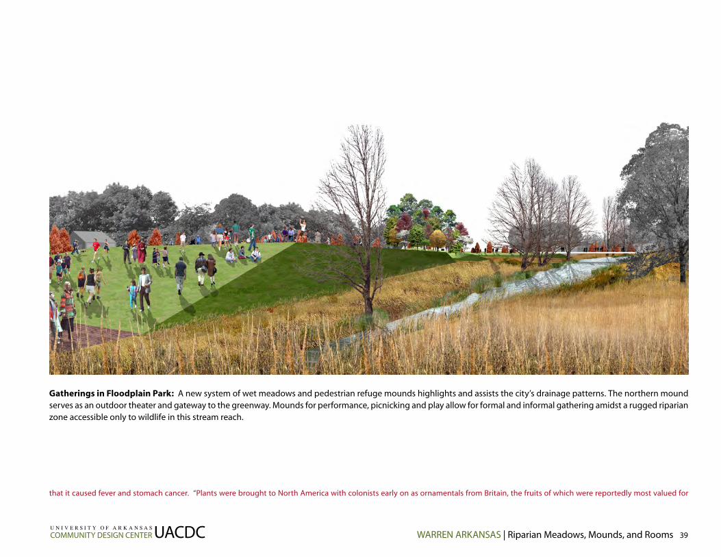
Gatherings in Floodplain Park: A new system of wet meadows and pedestrian refuge mounds highlights and assists the city’s drainage patterns. The northern mound serves as an outdoor theater and gateway to the greenway. Mounds for performance, picnicking and play allow for formal and informal gathering amidst a rugged riparian zone accessible only to wildlife in this stream reach.
WARREN ARKANSAS | Riparian Meadows, Mounds, and Rooms 39UACDCU N I V E R S I T Y O F A R K A N S A S
COMMUNITY DESIGN CENTER
that it caused fever and stomach cancer. “Plants were brought to North America with colonists early on as ornamentals from Britain, the fruits of which were reportedly most valued for

Floodplain Park: Meadows and Mounds: Floodplain Park provides new flood storage capacity for Warren, which experiences significant and recurring flooding as Town Branch Creek passes through the community. Wet meadows accommodate a combination of stream baseflow and urban stormwater runoff from downtown. The tall grass meadow serves as a low-maintenance landscape matrix, conveying an expansive visual order for the western edge of downtown.
U N I V E R S I T Y O F A R K A N S A S
COMMUNITY DESIGN CENTERUACDC40 Riparian Meadows, Mounds, and Rooms | WARREN ARKANSAS
pustule removing properties.” Though New Orleans cuisine had incorporated the tomato by 1812, the fruit was avoided in many areas. By 1840, “every pill and panacea was extract of tomato”.
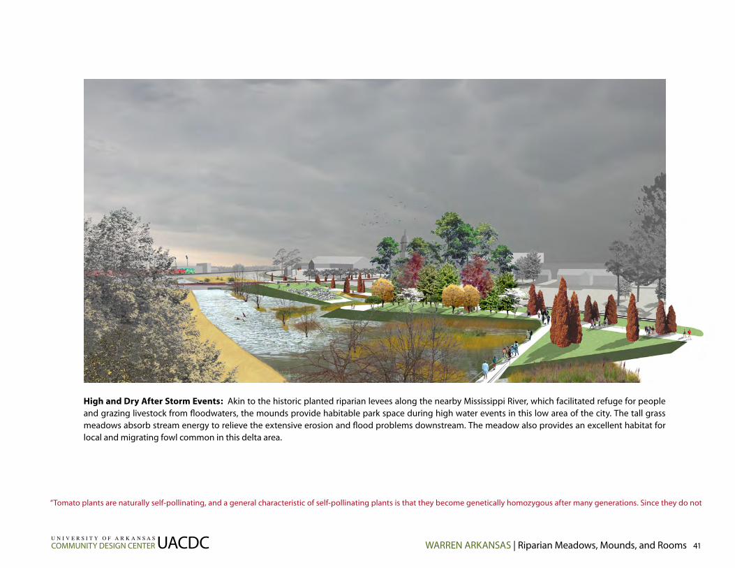
High and Dry After Storm Events: Akin to the historic planted riparian levees along the nearby Mississippi River, which facilitated refuge for people and grazing livestock from floodwaters, the mounds provide habitable park space during high water events in this low area of the city. The tall grass meadows absorb stream energy to relieve the extensive erosion and flood problems downstream. The meadow also provides an excellent habitat for local and migrating fowl common in this delta area.
WARREN ARKANSAS | Riparian Meadows, Mounds, and Rooms 41UACDCU N I V E R S I T Y O F A R K A N S A S
COMMUNITY DESIGN CENTER
“Tomato plants are naturally self-pollinating, and a general characteristic of self-pollinating plants is that they become genetically homozygous after many generations. Since they do not

Reach 3: YMCA Water Walk
Reach 3: YMCA Water Walk proposes reopening the stream to the surface and planting of the stream’s riparian zone as a pedestrian armature along Ash Street. This would entail rotation of the baseball field to its original position fronting the railroad right-of-way and relocation of supporting recreational service structures. Internalization of service structures related to restrooms, concession stands, announcement boxes, viewing stands and dugouts to the interior of the block, and away from the street, improves safety for children.
Though it may still accommodate local traffic, Ash Street should be considered more a “parking garden” than a thru street. Ash Street could function in the tradition of a “shared street” where motorists and pedestrians equally share street space and right-of-way. The street is essentially designed as a garden with landscape simultaneously acting as a traffic-calming device and as a pedestrian amenity to facilitate walking and gathering. Vegetation along the parallel riparian edge amplifies the landscaping in Ash Street. The YMCA Quonset hut building, a local point of interest (the barrel vault-like space of the interior cannot be matched), should be rehabilitated as a recreational and social asset to Main Street, and as a gateway to Ash Street. A new plaza, link-ing the refurbished Quonset hut and a planned addition to the main YMCA building, accommodates both active and passive outdoor activities.
Expansion of the stream bankfull and floodplain will assist to mitigate the existing flood problem and prevent its predicted intensification. However, if structural engineering stream management practices related to channeliza-
U N I V E R S I T Y O F A R K A N S A S
COMMUNITY DESIGN CENTERUACDC42 Riparian Meadows, Mounds, and Rooms | WARREN ARKANSAS
naturally outcross very often, seeds of a tomato will produce plants resembling the parents. Early cultivars did not change much because of

Refurbished Quonset hut
Parking and pedestrain plaza
YMCA Water Walk: The YMCA Water Walk reopens the piped stream to the surface and replants the stream’s riparian zone as a pedestrian armature along Ash Street. Neighboring Ash Street is converted from a thru street to a “shared street” condition. Ash Street becomes more a “parking garden” as motorists and pedestrians equally share street space and right-of-way. The street is essentially a garden with landscape simultaneously acting as a traffic-calming device and as a pedestrian amenity to facili-tate socializing. The reclaimed riparian corridor and street are combined to yield a hybrid ecological-infrastructural urban element.
Sports equipment (basketball, street hockey, skateboarding, etc.)
Shared street
Metal grating over stream at plaza
Riparian belt
Uncover stream
Stormwater gardens
Existing and proposed YMCA buildings
Consolidated refreshment and restroom facilities
Pervious parking and specimen tree
Relocated ball field and bleachers
Tree buffer
Extended floodplain/ wetland
Purchase and remove existing residence and return to floodplain condition
WARREN ARKANSAS | Riparian Meadows, Mounds, and Rooms 43UACDCU N I V E R S I T Y O F A R K A N S A S
COMMUNITY DESIGN CENTER
this property, and were kept in a family or community for long periods of time, thus earning the name heirlooms. Heirloom cultivars dating back over a hundred years are still grown today.

The Y Plaza: The YMCA Quonset hut building, a local point of interest (the barrel vault-like space of the interior cannot be matched), is rehabilitated as a recreational and social asset to Main Street, and as a gateway to the YMCA Water Walk. A new plaza, linking the porous, refurbished Quonset hut and a planned addition to the main YMCA building, accommodates both active and passive outdoor activities. The Y Plaza is the eastern anchor of the urban greenway.
tion, culverting, and increases in impervious ground surface are continued in this reach of the stream, flooding problems will intensify. Building over a watershed (whether the water is piped underground or on the surface) is several times costlier in both initial and life cycle expenses than conven-tional practice, and represents a suboptimal use of resources. The YMCA is a distinguished community institution and its development practices should demonstrate pace-setting stewardship befitting of its civic importance.
Hanging Gardens?
U N I V E R S I T Y O F A R K A N S A S
COMMUNITY DESIGN CENTERUACDC44 Riparian Meadows, Mounds, and Rooms | WARREN ARKANSAS
Most heirloom varieties are unique in size, shape or color. Some are black, dark purple, or red with black shoulders. Many are green, some have green stripes. Some are rainbow colored, or

WARREN ARKANSAS | Riparian Meadows, Mounds, and Rooms 45UACDCU N I V E R S I T Y O F A R K A N S A S
COMMUNITY DESIGN CENTER
shaped like peppers. Of course there are orange and yellow cultivars too, and everything in between. Some are cherry size, some are over 2 pounds.” “Canning of tomatoes was first docu-

Thank You Potlatch!: The new ball field facilities could show off the timber products made by the local employment force and Potlatch Corporation. Inexpensive materials like chain link fence, translucent polycarbonate panels, and locally produced wood products are combined to make dugouts, viewing stands, concession stands and public restrooms. Ordinary elements and materials could be combined to make an extraordinary outdoor recreation facility for the YMCA.
Polycarbonate gateway
Parking
Wooden dugouts
Wooden bleachers
Chain link fence
Pedestrian bridge to shared street Concessions
and restrooms
U N I V E R S I T Y O F A R K A N S A S
COMMUNITY DESIGN CENTERUACDC46 Riparian Meadows, Mounds, and Rooms | WARREN ARKANSAS
mented in 1847 by Harrison Crosby of Lafayette College in Easton, Pennsylvania.” “Juice extractors were invented in the 1920’s. Shortly after, a young entrepreneur named Joseph Campbell

WARREN ARKANSAS | Riparian Meadows, Mounds, and Rooms 47UACDCU N I V E R S I T Y O F A R K A N S A S
COMMUNITY DESIGN CENTER
found a ready market for canned tomato products, and went on to make millions with his soup company.” Roma is a backyard favorite spanning half a century of cultivation and has been

Project AdministrationRecommendations
v
Riparian Meadows, Mounds, and Rooms outlines a range of solutions from those requiring minimal resources to more ambitious proposals. Design and engineering recommendations specific to each greenway segment are out-lined and summarized in their respective sections. Environmental engineering recommendations are outlined and summarized in the section: “Ecological Analysis of Town Branch Creek”.
The greenway can be incrementally phased as funding, technical resources, and political will permit. The study is not intended to be a “blueprint” for new construction, but rather a planning document to direct more detailed design studies, leading to new construction projects. Procuring professional design services from the private sector in collaboration with technical assistance from state agencies will be necessary to fulfill the recommendations outlined in Riparian Meadows, Mounds, and Rooms.
The following are recommendations for the next steps.
• Continue work through the Townscape Committee, which has proven to be an effective and knowledgeable organization for pursuing civic develop-ment issues in Warren.
• Pursue funding opportunities with private foundations and government agencies, particularly those sponsors whose award profiles privilege environ-mental issues. The recombinant design principles pose a better chance of private and multiple agency funding. Integrated design solutions combining
multiple interests will especially attract funding interested in new approaches for public works projects.
• Coordinate further technical assistance from state extension agencies like the Arkansas Forest Commission, Arkansas Department of Environmen-tal Quality, and the Arkansas Soil and Water Conservation Commission. The Arkansas Forest Commission can provide expertise on tree planting and plant sociology appropriate to the local riparian edge condition. The Arkansas Department of Environmental Quality can collaborate with city officials in bringing municipal waste infrastructure into compliance with federal and state legislation governing clean water. The Arkansas Soil and Water Conser-vation Commission can provide further field assistance with stream design and rehabilitation.
• Contract with the University of Arkansas Biological and Agricultural Engineering Department (BAEG) for further ecological assessments, design development and construction administration of stream improvements. BAEG will also coordinate any required permit applications for stream improvement and work with the local Arkansas Soil and Water Conservation Commission field representative.
• Contract with a professional landscape architect for Design Development and Construction Administration services. The UACDC would like to remain involved with the project as a design and planning partner.
U N I V E R S I T Y O F A R K A N S A S
COMMUNITY DESIGN CENTERUACDC48 Riparian Meadows, Mounds, and Rooms | WARREN ARKANSAS
widely used for sauces because of its high solids content.” “The very best tasting tomatoes are those that are grown at home in soil rich with compost.” “In 1981, the USDA chairman declared
ketchup to be a vegetable in order to justify Reagan administration budget cuts in the school lunch program.” “In the 1980’s a project was undertaken by Calgene Fresh, Inc. using biotechnology
to tweak the tomato genetics to inactivate the gene responsible for softening the tomato during ripeness. These tomatoes turned red, but remained firm indefinitely. They called this culti-
var Flavr Savr because vine-ripening supposedly gave it better flavor. It hit the produce sections of stores in the US during 1993. The Flavr Savr tomato represents one of the greatest public
relations blunders of the decade. Industry executives severely underestimated the public’s concern over biotechnology, and failed to anticipate the backlash from consumers over this new
and potentially risky technology applied to human food.” “…tomatoes harvested green to prevent bruising and spoilage during shipment don’t produce the natural ripening gas, ethylene.
Even when these green tomatoes are artificially ripened with ethylene, the immature fruit lacks the complex brew of sugars and acids that makes home grown tomatoes so tasty. Theologis
and his team located the gene that triggers ethylene production. They manipulated the genetic sequence using “splicing techniques” and reinserted it into the DNA of the tomato cells. In
theory this would prevent the test tomato from producing ethylene on the vine.” “The latest buzz surrounding tomatoes is the purported benefit of lycopene, the major carotenoid contained
in tomatoes that is responsible for the deep red color. Tomatoes are an excellent source of lycopene, and numerous studies have confirmed that people who consume increased amounts

• Coordinate Design Development of Reach 3 with the YMCA and their design consultants. The city may consider offering development incentives to achieve better site development practices from the YMCA.
• Enroll the City of Warren in the Federal Emergency Management Agency’s National Flood Insurance Program. The Arkansas Soil and Water Conservation Commission can assist with this effort. Enrollment would relieve the city of liability and recurring payouts to individual property owners from damages caused by flooding.
• The greenway system should also contain a heritage component celebrat-ing the tomato, and perhaps the pine tree, as commodities important to the community’s identity. The heritage component would be developed in the Design Development Phase of work, once a design professional is hired.
• If property along the stream cannot be purchased, secure access ease-ments along the greenway from private owners for purposes of connectiv-ity.
• Further information on riparian corridors is available and well illustrated in Stream Corridor Restoration: Principles, Processes, and Practices by the Federal Interagency Stream Restoration Working Group (1998). The report is available on the internet at www.usda.gov/stream_restoration.
Tomato References:http://www.webterrace.com/tomato/history.htmhttp://www.tomato-cages.com/tomato-history.htmlhttp://www.vegparadise.com/highestperch8.htmlhttp://www.pallensmith.com/report_library/archive/333_tomato-history.htmlhttp://myweb.cableone.net/tfcox/tomato.htmhttp://lamar.colostate.edu/~samcox/Tomato.html
WARREN ARKANSAS | Riparian Meadows, Mounds, and Rooms 49UACDCU N I V E R S I T Y O F A R K A N S A S
COMMUNITY DESIGN CENTER
of tomato products experience marked reductions in cancer risk.” “The top five tomato
producing countries of the world are United States, China, Turkey, Italy and India, in that order.
Within the US, Florida, California and Georgia are the top commercial producing states, with
about 200 square miles under cultivation in 1997. An estimated 35 million backyard gardens
across the country grow tomatoes as well.” “A University of California at Davis survey ranked
the tomato as the single most important fruit or vegetable of western diets in terms of over-
all source of vitamins and minerals.” Tomatoes contain approximately 35 calories for a medium
tomato. “To refrigerate or not to refrigerate is the question. Tomatoes purchased from the
supermarkets have been refrigerated, and will not keep well unrefrigerated. However, toma-
toes fresh from the garden will keep quite well at room temperature for about a week, as will
those organically grown from farmers’ markets.” Tomatoes prefer a neutral soil (pH between
six and seven) with good drainage. “Heirloom tomato grower Maryann Underwood recom-
mends growing marigolds between tomato plants. The flower’s strong scent drives off pests
while attracting pollinators such as bees.” “The world record for heaviest tomato goes to
Gordon Graham of Edmond, Okla., for a seven-pound, 12-ounce Delicious.”

