river bourne sfra technical report - woking 2027 · volume 2: technical report (final) capita...
TRANSCRIPT
WOKING AND SURREY HEATH STRATEGIC FLOOD RISK ASSESSMENT
For WOKING BOROUGH COUNCIL and SURREY HEATH BOROUGH COUNCIL
MARCH 2007
VOLUME 2: TECHNICAL REPORT
(FINAL)
Capita Symonds © Capita Symonds Ltd
24-30 Holborn London
EC1N 2LX
Tel: 02078709300 Fax: 02078709399
Email: [email protected]
Woking and Surrey Heath SFRA
Woking Borough Council and Surrey Heath Borough Council
March 2007
Woking and Surrey Heath Strategic Flood Risk
Assessment
Technical Document
Final Report REV 0.0 / March 2007
This document is the property of the Woking Borough Council and
Surrey Heath Borough Council and its contents are confidential. If you
have received it in error, please return it immediately to one of the
above named Local Authorities.
Job Number: CS/021102
PD: AGJD
PM: RG
Report status: FINAL REV 0.0
Date of issue: 19/03/07
CSL Main author(s): CB/SC
CSL Checked: RG
Client Approval: -
This report has been prepared by Capita Symonds Limited with all
reasonable skill, care and diligence within the terms of the Contract with
the Client, incorporating our General Terms and Conditions of Business
and taking account of the resources devoted to it by agreement with the
client. We disclaim any responsibility to the client and other in respect
of any matters outside the scope of the above. This report is
confidential to the client and we accept no responsibility of whatsoever
nature to third parties to whom this report, or any part thereof, is made
known. Any such party relies on the report at their own risk

Woking and Surrey Heath SFRA
Woking Borough Council and Surrey Heath Borough Council
March 2007
PREFACE
It is accepted that the technical content of the Woking & Surrey Heath SFRA will need to be
reviewed and amended as new information becomes available.
Although there is no statutory consultation requirement at this stage the nature of the intended
end use for the information makes it appropriate to obtain feedback relating to the report in
order to contribute to the overall robustness and credibility of this work. This information will also
be an aid when formulating the necessary next steps in engaging those parties who will be
involved in the future.
It is the responsibility of the reader to be satisfied that they are using the most up to date
information and that this has been included within the Woking & Surrey Heath SFRA.
Woking and Surrey Heath SFRA
Woking Borough Council & Surrey Heath Borough Council Page iii
March 2007
CONTENTS
PREFACE ..................................................................................................................................... II
GLOSSARY ................................................................................................................................VII
1. INTRODUCTION ...................................................................................................... 1
2. DOCUMENT REGISTER.......................................................................................... 2
3. ENVIRONMENTAL AND PLANNING CONTEXT ................................................... 3 Background ............................................................................................................. 3
Introduction ............................................................................................................. 3
National Flood Risk Policy..................................................................................... 3
Regional Flood Risk Policy.................................................................................... 5
4. METHODOLOGY ..................................................................................................... 7 Principles................................................................................................................. 7
Flood Risk Assessments ....................................................................................... 8
Long Term Management ........................................................................................ 8
5. CATCHMENT DESCRIPTION ............................................................................... 10 The Catchment ...................................................................................................... 10
Regional Geology ................................................................................................. 11
Watercourses in the Study Area ......................................................................... 11
Topography ........................................................................................................... 12
The Record of Flooding in the Addlestone Catchment .................................... 13
Flooding Processes Within the Catchment ....................................................... 13
Flood Defences in the Study Area ...................................................................... 13
Structures over Watercourses ............................................................................ 14
Drainage and Surface Water................................................................................ 14
6. DATA REVIEW....................................................................................................... 16
7. HYDROLOGICAL ANALYSIS ............................................................................... 18 Catchment Characteristics .................................................................................. 18
Catchment Hydrology........................................................................................... 18
8. HYDRAULIC ANALYSIS........................................................................................ 20 Introduction ........................................................................................................... 20
Approach ............................................................................................................... 20

Woking and Surrey Heath SFRA
Woking Borough Council & Surrey Heath Borough Council Page iv
March 2007
Flood Model Selection.......................................................................................... 20
Flood Model Development ................................................................................... 21
Flood Model Inflows ............................................................................................. 21
Downstream Boundary......................................................................................... 22
Model Calibration and Sensitivity Testing ......................................................... 22
Hydraulic Modelling to Define Flood Zones....................................................... 23
Hydraulic Modelling to Define Actual Risk......................................................... 24
Hydraulic Modelling to Define Residual Risk .................................................... 24
9. OTHER SOURCES OF FLOODING ...................................................................... 25 Groundwater, Surface Water and Other Sources of Flooding ......................... 25
The Basingstoke Canal ........................................................................................ 27
10. MAPPING OF FLOOD EXTENTS.......................................................................... 30 Floodplain Topographic Survey.......................................................................... 30
Methodology.......................................................................................................... 30
Recommendations................................................................................................ 31
11. UNCERTAINTIES IN FLOOD RISK ASSESSMENT............................................. 32 Generic Risks and Uncertainties......................................................................... 32
12. STRATEGIC FLOOD RISK ASSESSMENT.......................................................... 34 Introduction ........................................................................................................... 34
Justification and Statutory Responsibilities...................................................... 34
Approach ............................................................................................................... 35
STAGE 1 – Flood Zone Review............................................................................ 36
STAGE 2 – Assessment of Actual Risk .............................................................. 38
STAGE 3 – Assessment of Residual Risk .......................................................... 43
STAGE 4 – Assessment of Breach Hazard......................................................... 44
Application of the Woking and Surrey Heath SFRA.......................................... 45
Implementation of the SFRA................................................................................ 48
Emergency Planning ............................................................................................ 48
Summary of Strategic Flood Risk Assessment................................................. 49
13. SFRA GUIDANCE FOR PLANNERS .................................................................... 50
14. CONCLUSIONS ..................................................................................................... 58 Summary of Flood Risk in the Woking and Surrey Heath SFRA Study Area. 58
Outcomes of the Strategic Flood Risk Assessment ......................................... 59

Woking and Surrey Heath SFRA
Woking Borough Council & Surrey Heath Borough Council Page v
March 2007
15. REFERENCES ....................................................................................................... 60
Woking and Surrey Heath SFRA
Woking Borough Council & Surrey Heath Borough Council Page vi
March 2007
APPENDICES (INCLUDED AS A SEPARATE DOCUMENT VOLUME 3 - APPENDICES)
Appendix A – Risk Based Sequential Approach
Appendix B – Catchment Information
Appendix C – Flood Zones
Appendix D – Actual Risk
Appendix E – Residual Risk
Appendix F – Hazard Maps
Appendix G – Hydraulic Modelling Results
Appendix H – Flood Risk from the Basingstoke Canal
Woking and Surrey Heath SFRA
Woking Borough Council & Surrey Heath Borough Council Page vii
March 2007
GLOSSARY
Actual Risk The risk from flooding based on best available information
and representing the influence of flood defences and the
distribution of risk within the Flood Zones.
BHS British Hydrological Society
cu.m (cumecs) Cubic metres of water per second
DCLG Department for Communities and Local Government
(previously ODPM)
DEFRA Department for Environment, Food and Rural Affairs
DTM Digital Terrain Model created using LiDAR, IfSAR or
Photogrammetry data.
EA Environment Agency
FEH The Flood Estimation Handbook (1999) gives guidance on
rainfall and river flood frequency estimation in the UK and is
the main method used for the calculation of peak flood flows.
The Handbook is accompanied by the FEH CD-ROM
containing catchment descriptors and gauging station details
for catchments throughout the UK.
Flood Zones This refers to the Flood Zones in accordance with Table D1
of PPS 25 derived for this Woking and Surrey Heath SFRA
and do not refer to the Environment Agency’s Flood Zones.
Flood Zones (EA) This refers to the Environment Agency’s Flood Zones.
FSR Flood Studies Report (1975) the predecessor method of
flood peak estimation in the UK largely superseded by the
Flood Estimation Handbook.
GIS Geographical Information System
IFSAR (NEXTmap) Interferometric Synthetic Aperture - An aircraft-mounted
sensor designed to measure surface elevation, which is used
to produce topographic imagery. Sold under the name
NEXTmap.
iSIS iSIS Flow is a one-dimensional fully hydrodynamic simulator
for modelling flows and levels in open channels and
estuaries; it incorporates both unsteady and steady flow
solvers.
Woking and Surrey Heath SFRA
Woking Borough Council & Surrey Heath Borough Council Page viii
March 2007
JFLOW JFLOW is a 2-D flood routing program developed by JBA,
which is able to calculate time travel across flood cells and
simulate inundation extent based on the accuracy of an
underlying Digital Elevation Model
Km2 Square kilometres
LiDAR Light Detection and Ranging survey method used to collect
data for construction of a ground model.
M Metres
m/sec Metres per second
mAOD Metres Above Ordnance Datum
Main River As Defined by the Environment Agency main rivers are
usually larger streams and rivers, but also include smaller
watercourses of strategic drainage importance. A main river
is defined as a watercourse shown as such on a main river
map, and can include any structure or appliance for
controlling or regulating the flow of water in, into or out of the
main river. The Agency’s powers to carry out flood defence
works apply to main rivers only. Main rivers are designated
by the Department for Environment, Food & Rural Affairs in
England and by the Welsh Assembly Government.
mm Millimetres
NEXTMAP Digital terrain elevation and radar image data
ODPM Office of the Deputy Prime Minister (now DCLG)
Ordinary Watercourse As Defined by the Environment Agency an ordinary
watercourse is every river, stream, ditch, drain, cut, dyke,
sluice, sewer (other than public sewer) and passage through
which water flows which does not form part of a main river.
On ordinary watercourses, the local authority and, where
relevant, IDBs have similar permissive powers as the Agency
has on main rivers.
PPG 25 Policy Planning Guidance Note 25: Development and Flood
Risk - Guidance explaining how flood risk should be
considered at all stages of the planning and development
process in order to reduce future damage to property and
loss of life.

Woking and Surrey Heath SFRA
Woking Borough Council & Surrey Heath Borough Council Page ix
March 2007
PPS 11 PPS11 Regional Spatial Strategies. This Statement replaces
Planning Policy Guidance note 11 - Regional Planning and
sets out the procedural policy on the nature of Regional
Spatial Strategies (RSS) and focuses on procedural policy,
on what 'should' happen in preparing revisions to them and
explains how this relates to the Act and associated
regulations.
PPS 12 PPS12 Local Development Frameworks. This statement
replaces Planning Policy Guidance note 12 - Development
Plans and sets out the Government's policy on the
preparation of local development documents which will
comprise the local development framework.
PPS 25 Planning Policy Statement 25. Development and Flood Risk
Guidance replacing PPG 25 in December 2006 and outlining
how flood risk should be considered at all stages of the
development process.
Precautionary Principle “Where there are threats of serious or irreversible damage,
lack of full scientific certainty shall not be used as a reason
for postponing cost effective measures to prevent
environmental degradation’’. The precautionary principle
was stated in the Rio Declaration in 1992. Its application in
dealing with the hazard of flooding acknowledges the
uncertainty inherent in flood estimation.
QMED The median flood flow calculated in the FEH method and
used to estimate flood peaks by the statistical method in the
WINFAP package. This is the flood that can be said to occur
with a return period of two years (50% annual probability).
Residual Risk An event more severe than that for which particular flood
defences have been designed to provide protection.
Return Period The average time until the next occurrence of a defined
event.
Section 105 Environment Agency Floodplain Modelling produced from
hydrological and hydraulic modelling.
Sequential risk-based
assessment
Priority in allocating or permitting sites for development, in
descending order to the Flood Zones set out in Table D1 of
PPS 25, including the sub divisions in Zone 3. Those
responsible for land development plans or deciding
applications for development would be expected to
demonstrate that there are no reasonable options available
in a lower- risk category.
Woking and Surrey Heath SFRA
Woking Borough Council & Surrey Heath Borough Council Page x
March 2007
SFRA Strategic Flood Risk Assessment
SHBC Surrey Heath Borough Council
Study Area Refers to the combined Woking and Surrey Heath Boroughs.
TUFLOW A two-dimensional fully hydrodynamic modelling package.
The TUFLOW model differs from the iSIS model in that it
models the whole floodplain as 2D domains, providing a
more complete description of flood behaviour where complex
overland flows and backwater filling occur.
WBC Woking Borough Council
WINFAP-FEH WINFAP is the software package associated with the Flood
Estimation Handbook and FEH flood peak dataset used to
calculate flood flow peaks by the FEH statistical method.
1D 1 Dimensional
2D 2 Dimensional
1 in 20 year return period flood
event
The flood event that is predicted to occur with an annual
probability of 5.0% (there is a 1 in 20 (5%) chance each year
this event will be witnessed).
1 in 100 year return period
flood event
The flood event that is predicted to occur with an annual
probability of 1.0% (there is a 1 in 100 (1%) chance each
year this event will be witnessed)
1 in 1000 year return period
flood event
The flood event that is predicted to occur with an annual
probability of 0.1% (there is a 1 in 1000 (0.1%) chance each
year this event will be witnessed)
Woking and Surrey Heath SFRA
Woking Borough Council & Surrey Heath Borough Council Page 1
March 2007
1. INTRODUCTION
1.1 This document is the Volume 2: Technical Report of the Woking and Surrey Heath
SFRA, and should be read in conjunction with the Woking and Surrey Heath Volume 1: Main
Report. Volume 1 (The Main Report) provides a summary of the background and methodology
adopted for assessing strategic flood risk. The main report also includes the Strategic Flood
Risk Assessment, described here in chapter 12.
1.2 This document outlines and explains the strategy adopted to assess strategic flood risk
issues in the Woking and Surrey Heath Boroughs. The principal requirement for adopting a
strategic approach to the assessment and consideration of flood risk is in accordance with
advice given in Planning Policy Guidance Note 25 (PPG 25, ODPM July 2001) and Planning
Policy Statement 25 (PPS 25, DCLG 2006).
1.3 The approach adopted has primarily been developed in recognition of the need to
provide flood risk information to support appropriate land use allocations within the Woking
and Surrey Heath Boroughs and to support the application of the sequential test.
1.4 The underlying objective is to initiate a strategy that provides a framework for the
consistent consideration of flood risk in seeking to accommodate current practice and best
available data for the lifetime of the planning process. This framework will be used to inform
the emerging Local Development Frameworks (LDF).
1.5 The assessment evaluates risk as the product of the probability and the consequence of
a particular hazard event. Probability is defined as the frequency and magnitude of floods that
are generated by fluvial flows and intense rainfall activity. The consequence is defined as the
impact of floodwater on receptors (people, property, land, etc). This approach is sympathetic
to the concept of source, path and receptor now adopted for flood risk management.
1.6 This document does not replace, and should be read in conjunction with, national and
regional policy including PPS 25 and relevant regional policy. The SFRA does not replace the
responsibility at a broader level to consider wider catchment flood risk management
approaches and solutions, nor does it remove the requirement for appropriately focused
local/site FRA’s.
1.7 This Strategic Flood Risk Assessment (SFRA) assesses the Flood Zones, Actual Flood
Risk and Residual Risk for the existing conditions within the Study Area (as defined in
Appendices C, D and E).
1.8 This report is a full technical report documenting the assumptions, processes and
assessment undertaken in the development of the SFRA. It is intended to serve as a
transparent record of the decisions and methodology that led to the outcomes of the SFRA.
Woking and Surrey Heath SFRA
Woking Borough Council & Surrey Heath Borough Council Page 2
March 2007
2. DOCUMENT REGISTER
2.1 The Woking and Surrey Heath SFRA (this document) is a live document requiring
review in the event of an improvement or change in the fundamental principles or best
available data underpinning the strategy. This is likely to include, but should not be limited to:
(i) An improvement in the best available information or a reduction in uncertainty as identified in Section 11.
(ii) Revision to relevant policy, plans or guidance.
(iii) Outcomes of neighbouring strategies.
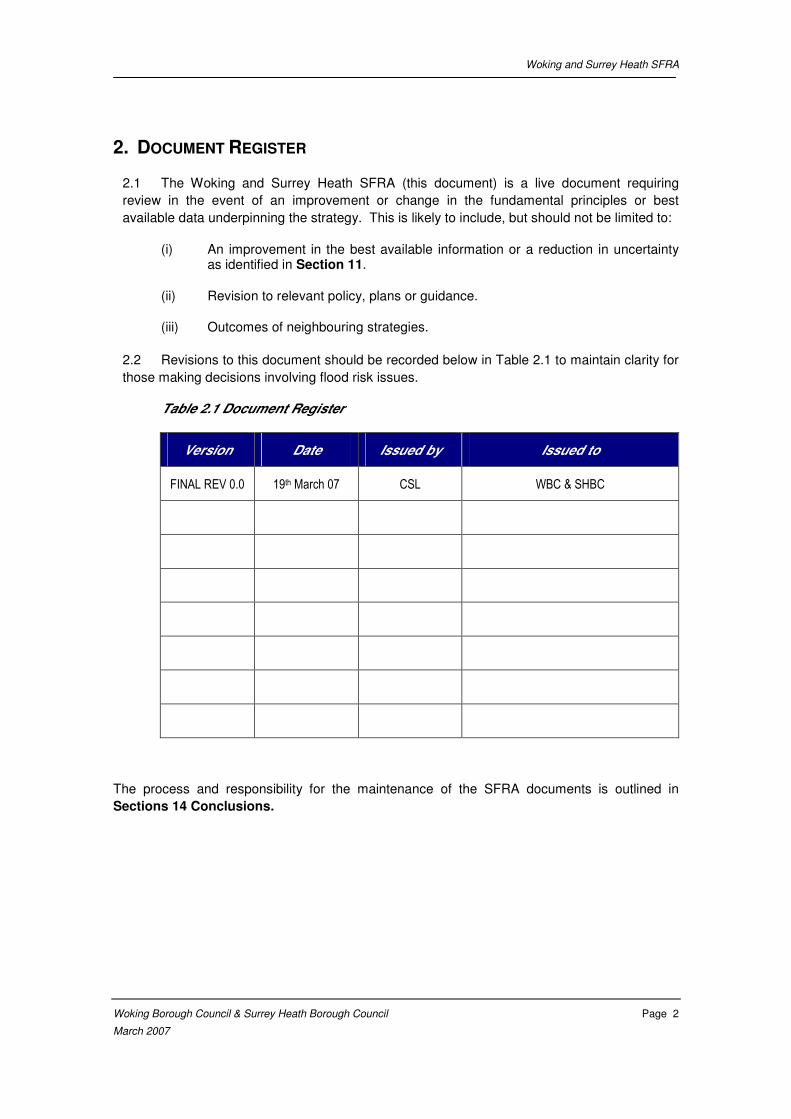
2.2 Revisions to this document should be recorded below in Table 2.1 to maintain clarity for
those making decisions involving flood risk issues.
Table 2.1 Document Register
Version Date Issued by Issued to
FINAL REV 0.0 19th March 07 CSL WBC & SHBC
The process and responsibility for the maintenance of the SFRA documents is outlined in
Sections 14 Conclusions.

Woking and Surrey Heath SFRA
Woking Borough Council & Surrey Heath Borough Council Page 3
March 2007
3. ENVIRONMENTAL AND PLANNING CONTEXT
Background
3.1 The Woking and Surrey Heath SFRA covers an area of 90km2, and within this area the
Addlestone and Hale Bourne are the primary watercourses, The Windle Brook rises north of
Bagshot and then becomes the Hale Bourne further downstream. The Hale Bourne flows in an
easterly direction towards Chobham where it joins the Addlestone Bourne. The Addlestone
Bourne then continues until its confluence with the River Wey and the Chertsey Bourne. The
River Blackwater flows along the western boundary of the area but does not have a significant
catchment within the SFRA area.
3.2 Current flood risk management measures are confined to localised flood bunds, bank
protection, balancing ponds, and sluices. Towards Addlestone a number of improvements
have been made to the channel with the aim of increasing conveyance. No formal raised flood
defences exist within the SFRA study area.
3.3 The Study Area includes a section of the Basingstoke Canal, which is owned and
managed by British Waterways, and used mainly for recreational purposes.
Introduction
3.4 There is a need to consider the policy context for the strategic assessment of flood risk
in the Woking and Surrey Heath SFRA area. Both regional policy directly related to Woking
and Surrey Heath and more broad scale national policy guidelines have been considered.
National Flood Risk Policy
Planning Policy Statement 25 (PPS25)
3.5 PPS25 was issued in December 2006 and replaces PPG 25. PPS 25 generally follows
the guidance originally described in PPG 25, advising that a strategic approach to flood risk
should be adopted in keeping with Government’s aims to ensure that new development is
sustainable. However, notably it introduces:
• The concept of classification of the vulnerability of development to flood risk;
• The need to conform to the requirements of the “Exception Test” in circumstances where it is deemed necessary to locate new development in “high risk” Flood Zones;
• It identifies the need to apply Strategic Flood Risk Assessment to decisions taken at all levels of planning, i.e. the need for assessment at the Regional Spatial Strategy level; and
• Additionally the PPS introduces the concept of Flood Risk Reduction, particularly in circumstances where development has been justified on the basis of the “Exception Test”.
Woking and Surrey Heath SFRA
Woking Borough Council & Surrey Heath Borough Council Page 4
March 2007
3.6 PPS 25 reclassifies the Flood Zones as being “Low probability”, “Medium probability”
and “High probability”. PPS 25 provides the main context and the driver for preparation of this
SFRA, and states in relation to Local Development Documents that, “sustainability appraisals,
land allocation, and development control policies should all be informed by a SFRA carried out
in liaison with the Environment Agency”.
Policy and Practice for the Protection of Floodplains (Environment Agency, 1997)
3.7 In addition to the above, Environment Agency national policy is described in the
document Policy and Practice for the Protection of Floodplains. The main principles for this
document are:
• Development should not take place which has an unacceptable risk of flooding, leading to danger to life, damage to property and wasteful expenditure on remedial works
• Development should not exacerbate flooding elsewhere;
• To minimise increases in surface water runoff by incorporating runoff source control measures where appropriate;
• The Government policy on flood defence is consistent with sustainable development and recognises the need to maintain and protect floodplains avoiding inappropriate development.; and
• Development should not cause unacceptable detriment to the environment.
• Natural floodplain areas are retained and where practicable restored in order to fulfil their natural functions.
• Development should not take place which prejudices possible flood works to reduce flood risk;
The key engineering principles include:
• Development on a floodplain may be at risk from flooding. Protection by flood defences reduces, but does not eliminate that risk.
• Development in a floodplain may obstruct flood flows. If it does, flood levels upstream of the development are increased and this increases upstream flood risks.
• Development on a floodplain may reduce the amount of land available for flood water storage. Loss of flood water storage reduces flood attenuation which results in an increase in downstream flood levels, thereby increasing downstream flood risks.
• The adverse effects of inappropriate development, however small, are cumulative and can lead to significant problems in the longer term.
• The removal of any existing inappropriate developments, particularly during redevelopment, can help to restore the function of natural floodplains.

Woking and Surrey Heath SFRA
Woking Borough Council & Surrey Heath Borough Council Page 5
March 2007
• Development generally increases the amount of impermeable land in river catchments. This increases the amount and rate of surface water run-off which if unmanaged can increase river flows and the risk of flooding.
Development and Flood Risk – Guidance for the Construction Industry, CIRIA (2004)
3.8 This document provides guidance to developers and the construction industry on the
implementation of good practice in relation to flood risk and development process. The
following are noted to be important considerations:
• All developments, even those that lie outside Flood Zone 2 or 3, may lead to an increase in downstream flood risk due to increased runoff rates and volumes. Therefore, all new developments should be designed so that runoff from the development is considered and, if appropriate, controlled.
• Safe access to and from the development should be allowed for during a flood event
• The development design should be such that future users will not have difficulty obtaining insurance or mortgage finance as a result of flood risk issues.
The above should be met for the lifetime of the development including considerations
for climate change.
Regional Flood Risk Policy
3.9 Regional policy relating specifically to the Woking and Surrey Heath Boroughs is
contained in several plans and strategies. Key documents to consider are the Thames
Catchment Flood Management Plan, existing local plans of WBC and SHBC, and the
emerging Local Development Frameworks which this SFRA advises. In addition to these the
Environment Agency will be completing the Inception Stage of the Addlestone and Hale
Bourne Strategy in early 2007. The Wey Strategy Review is also an important document
relevant to WBC. Further details of the Wey Strategy Review are given in the Woking and
Guildford SFRA.
Thames Region Catchment Flood Management Plan (CFMP)
3.10 There is a Catchment Flood Management Plan (CFMP) for Thames Region, which
provides a broad scale assessment for the entire Thames Catchment. The Thames CFMP will
not provide the same level of detail relating to the Hale and Addlestone catchment as this
SFRA.
Addlestone Bourne Strategy Inception Study
3.11 The Environment Agency will be finalising the Strategy Inception phase in the near
future and do not anticipate that the study will progress to a full Strategy. They report that
there is little interconnectivity between flood risk areas and it is unlikely that any structural
schemes will be recommended to proceed to design stage. The key recommendations of the
strategy Inception are likely to be:
(i) Continuing with the current watercourse maintenance regime;

Woking and Surrey Heath SFRA
Woking Borough Council & Surrey Heath Borough Council Page 6
March 2007
(ii) Object to inappropriate development within the floodplain;
(iii) Promote use of SUDs and encourage Greenfield run-off rate for attenuation in
all new developments within the catchment;
(iv) Encourage people at risk to flood proof their homes; and
(v) Improve the flood warning system to better reflect catchment hydrology.
Local plans
3.12 The Woking and Surrey Heath Local Plans contain guidance on flood risk, the guidance
given does not deviate significantly from that given in PPG25 and other National Flood Risk
Policies.
Strategic Flood Risk Assessment
3.13 Six other boroughs bound the Woking and Surrey Heath SFRA Study area: Guildford,
Runnymede, Elmbridge, Mole Valley, Waverley, and Rushmoor.
3.14 Woking and Guildford have commissioned a joint SFRA to assess the flooding within
the Study Area associated with the Wey Catchment. This SFRA is currently in progress and
due for completion early 2007. Waverley Borough Council has published a draft SFRA
(October 2006) on its web site
Woking and Surrey Heath SFRA
Woking Borough Council & Surrey Heath Borough Council Page 7
March 2007
4. METHODOLOGY
Principles
4.1 The Woking and Surrey Heath SFRA has been prepared because there is a need to
provide information on flood risk to support the decision making process during land use
allocation and to inform development control and the potential scope of future FRAs that may
be required. The information provided for this purpose must:
(i) be based on the best available information at the time of submission;
(ii) be precautionary in accordance with PPS 25;
(iii) consider current and future flood risk for all sources;
(iv) address the need to accommodate changes in the level of uncertainty;
(v) result in the provision of consistent flood risk management measures for the
Study Area; and
(vi) provide a transparent tool for the long term management, maintenance and
review of flood risk.
4.2 The strategic approach to risk assessment requires that proposals take account of
present and future flood risks within the Study Area. Additionally PPS 25 advocates a
precautionary, risk based sequential approach when assessing flooding.
4.3 It is conventional to consider risk as the product of the probability and magnitude of the
hazard and the severity of the consequences.
4.4 The approach adopted in this SFRA addresses the consequences of inundation for
designated scenarios. The platform that can be used for the sequential characterisation of
flood risk is described in Appendix D PPS 25 in conjunction with Table D.1 to D.3 of PPS 25
as shown in Appendix A.
4.5 The Flood Zones available from the EA provided an initial broad indication of the areas
which may be at risk of flooding.
4.6 The Flood Zones in this SFRA are based on those provided by the Environment Agency
Flood Zone Maps (FZM’s), but in addition this study has completed and obtained detailed
modelling for some parts of the study area, which has been used to refine the EA Flood
Zones. Where detailed flood modelling was not available EA Flood Zones have been used.
The use of these Flood Zones is complemented by the preparation of plans identifying Actual
Risk and Residual Risk.
4.7 Having identified the Actual Risk associated with particular zones it is possible to
identify the appropriate development land use and the requirement for strategic responses or
flood risk management commitment.
Woking and Surrey Heath SFRA
Woking Borough Council & Surrey Heath Borough Council Page 8
March 2007
Flood Risk Assessments
4.8 To implement the strategy, and in accordance with PPS 25, detailed Flood Risk
Assessment submissions may subsequently need to be prepared to accompany planning
applications for particular development proposals.
4.9 The Flood Risk Assessments for particular applications will need to draw on information
derived from the Woking and Surrey Heath SFRA in conjunction with further detailed
hydrological and hydraulic analyses of the river and floodplain system where necessary.
Having developed or acquired hydraulic models for the baseline condition (within this SFRA) it
is proposed that the hydraulic models and the SFRA will be periodically updated as necessary
in future updates of the SFRA to take account of changing knowledge and circumstances, and
to provide the basis to predict the impact of development proposals and the requirements for
mitigation.
4.10 Site specific Flood Risk Assessments should asses risks associated with all types of
flooding, both in combination and individually. Types of flooding which should be considered
and may occur within the area covered by this SFRA include fluvial flooding, groundwater
flooding, flooding from overland flows, artificial drainage systems, and infrastructure failure.
Historic and anecdotal evidence of flooding should be considered as part of the assessment.
4.11 A GIS layer is provided with this SFRA which summarises known information on these
‘other’ sources of flooding. This dataset is based on information provided by SHBC, WBC and
the EA and is a record of known flooding problems and past events.
Long Term Management
4.12 The Woking and Surrey Heath SFRA is based on information that will inevitably be
amended by better data, changes in the baseline condition due to development, changing
institutional and policy conditions, and changing predictions of the effects of climate change.
To be robust and able to withstand challenge in the planning process there is a need to ensure
the Woking and Surrey Heath SFRA reflects conditions at the time particular evaluations are
made. Failure to maintain the SFRA into the future may reduce the effectiveness of flood risk
management measures; delay plan making and development processes and potentially lead
to the neglect of flood risk considerations and the failure to capture strategic responses and
interventions.
4.13 Accordingly it will be necessary to identify a “Management Group” of appropriately
selected parties with responsibility for monitoring, managing and maintaining the Woking and
Surrey Heath SFRA. This group will be led by representatives from the respective Boroughs.
Although the group may include representatives from other influential organisations. The EA
are likely to play a key role in providing technical and process guidance to this management
process.
4.14 The roles and terms of reference for the Management Group have not been identified in
this report. This group is crucial in making the technical information contained in the Woking
and Surrey Heath SFRA accessible and transparent to those responsible for land use
decisions.

Woking and Surrey Heath SFRA
Woking Borough Council & Surrey Heath Borough Council Page 9
March 2007
4.15 The prime responsibility for managing and maintaining this SFRA lies with the Planning
Policy Teams at WBC and SHBC. The SFRA will be reviewed annually as part of the annual
monitoring report.
Woking and Surrey Heath SFRA
Woking Borough Council & Surrey Heath Borough Council Page 10
March 2007
5. CATCHMENT DESCRIPTION
The Catchment
5.1 The Addlestone Bourne, and its tributary the Hale Bourne are the two principle
watercourses considered in this SFRA. The River Blackwater also flows along the edge of the
SFRA study area for a short distance.
5.2 The Addlestone Bourne is located to the west of London and drains primarily into the
Chertsey Bourne north of Ham Moor via the Woburn Park Stream. There is also a linkage to
the River Wey east of Ham Moor at Weybridge. The channel to the Wey is controlled by a
sluice which is normally kept closed and therefore in general the Wey does not impact on
conditions in the Addlestone Bourne.
5.3 The Addlestone/Hale Bourne has a catchment area of approximately 90km2 and as well
as the two main channels there are a number of other smaller tributaries including
Windlesham Ditch, Lightwater Stream, Chobham Park Brook, Clappers Brook, Knaphill Brook
and Parley Brook.
5.4 The northwest part of the catchment, from Bagshot Park and Pennyhill Park eastwards,
drains into the Hale Bourne and its tributaries, the largest of which are Clappers Brook and
Chobham Park Brook. The Hale Bourne feeds into the Addlestone Bourne around 3km east
of Chobham. Both the Hale Bourne and the Addlestone Bourne flow through the town of
Chobham which has experienced severe flooding in the past.
5.5 The south of catchment, from the head of the system at Lightwater Country Park, drains
into the Addlestone Bourne along with other major tributaries, Knaphill Brook and Parley
Brook, together with several smaller tributaries.
5.6 There is a lake within the Addlestone Bourne catchment at Goldsworth Park, it has a
catchment of approximately 1.5km2. The lake provides attenuation for the surrounding
residential areas. A small baseflow is able to drain under gravity into Parley Brook, as the
water level in the lake increases, a series of pumps operate which discharge flows of up to
0.85m3/s.
5.7 Runoff routes are influenced by the presence of the Basingstoke Canal and by artificial
surface water drainage networks, particularly in Woking. Certain parts of the Addlestone
Bourne catchment which lie to the south of the canal, have particular topography that result in
the runoff from these catchment flowing into the canal. This complicates the hydrology of the
area.
5.8 There are several significant urban areas in the catchment. In the West, the towns of
Bagshot, Windlesham, and Lightwater are within close proximity to the Hale Bourne. In the
centre of the catchment West End and Chobham are close to both the Hale and Addlestone
Bourne. Woking lies to the south of the catchment, with the towns of Addlestone and
Ottershaw lying at the most easterly end of the catchment close to the Addlestone Bourne.
Woking and Surrey Heath SFRA
Woking Borough Council & Surrey Heath Borough Council Page 11
March 2007
Regional Geology
5.9 This section describes the geology of the Addlestone Bourne catchment. The
underlying geology of the Addlestone/Hale Bourne catchment is predominately Bagshot Beds
(fine grained sands) with London Clay to the North.
5.10 In the Addlestone Bourne Middle Catchment the dominant geology is the Bagshot
Bedrock, with occasional superficial deposits of Alluvium. In the Addlestone Bourne Upper
Catchment the geology changes from Bracklesham Bedrock to Barton Bedrock as it moves
west. There are also superficial deposits of Plateau Gravel in the west of the area.
5.11 In the Hale Bourne Lower Catchment the geology is predominantly Bagshot Bedrock.
Along with this there are superficial deposits of river terrace gravels, such as Taplow and
gravels deposited on the floodplain. In the Hale Bourne Middle Catchment the underlying
geology is predominantly Bracklesham Bedrock. This catchment also contains superficial
deposits of peat. In the Hale Bourne Upper Catchment the underlying Bedrock merges from
Bracklesham to Barton Bedrock when travelling west. There are also superficial deposits of
Plateau Gravel.
5.12 The catchment geology and its’ influence on catchment hydrology is discussed in the
Environment Agency’s Addlestone/Hale Bourne Flood Mapping Study, Interim Hydrology
Report (Mott MacDonald, November 2005).
Watercourses in the Study Area
5.13 The Hale Bourne starts out as a small stream with the name of Windle Brook, which
rises at an unnamed lake in Bagshot Park. After flowing under the railway line it becomes the
Hale Bourne. It flows as an open channel, in quite a direct easterly direction. The Hale Bourne
runs to the north of Lightwater, then through Chobham before flowing into the Addlestone
Bourne 2km to the east of Chobham. It begins at a height of 60m AOD and at the confluence
with the Addlestone Bourne is at a height of 21m AOD. The Hale Bourne, including its source
watercourse of the Windle Brook, is approximately 10km long. The Hale Bourne travels under
both the railway line at Bagshot and the M3 motorway along its course towards the Addlestone
Bourne.
5.14 Along its path the Hale Bourne is joined by a number of smaller tributaries. In the Upper
Catchment it is met by the Lightwater Stream, which begins in the Pirbight Ranges to the
south of Lightwater before travelling northward to form a small lake in Lightwater. The
Lightwater Stream then runs through Lightwater and around the north of its sewage works
before meeting the Hale Bourne. In the Hale Bourne Middle Catchment the Clappers Brook
converges with the Hale Bourne. It begins in Brick Hill, the other side of the M3 before flowing
under the motorway and then around Westcroft Park. It meets the Hale Bourne to the south of
Shrubbs Farm. In the Hale Bourne Lower Catchment, the Chobham Park Brook joins the
Hale Bourne. It begins at two different sources, one in Burrowhill, the other from the woodland
to the north of Butts Hill. They converge to the north of Chobham Farm, where they split and
then rejoin before meeting the Hale Bourne by Emmetts Mill, approximately one kilometre to
the east of Chobham.
5.15 The Addlestone Bourne has its source in West End Common and Bisley Common. It
flows between the settlements of West End and Bisley and then to the south of Chobham
Woking and Surrey Heath SFRA
Woking Borough Council & Surrey Heath Borough Council Page 12
March 2007
before meeting Hale Bourne. It meanders eastwards before its confluence with the Hale
Bourne.
5.16 After the Hale Bourne confluence the Addlestone Bourne continues up through
Addlestone and eventually meets the Woburn Park Stream which leads it to the Chertsey
Bourne. There is a connection to the River Wey at Weybridge, but a sluice gate is in place. It
flows predominantly as open channel, in an easterly direction. It is largely a rural catchment
with the town of Addlestone being the largest urban area within the catchment. The
Addlestone Bourne flows beneath the M25 and a railway line by Addlestone on its course to
drain into the Chertsey Bourne.
5.17 Along its path, the Addlestone Bourne is joined by a number of smaller tributaries. In the
Upper Catchment there are three very small-unnamed tributaries that join the Addelstone
Bourne, beginning in Bisley, Penny Pot and Brook Place respectively. In the Addelstone
Bourne Middle Catchment there is one major tributary that joins the Addlestone Bourne,
Parley Brook. Its source is the Goldsworth Park lake in west Woking. It travels northward for
short distances before converging with another tributary named the Knaphill Brook, which
begins in Littlewick and flows eastwards. They both converge just before the point at which
they meet the Addlestone Bourne to the north of Horsell Birch.
5.18 The River Blackwater rises to the south of Aldershot and flows around the south of the
town before turning north flowing adjacent to the A331. The River Blackwater flows under the
Basingstoke Canal and then continues adjacent to the A331 between Farnborough and
Mytchett, Frimley, and Camberley. The Cove Brook, a tributary of the Blackwater, flows
through Farnborough and into the Blackwater near Hawley. The Blackwater then flows west
past Yateley and Eversley to its confluence with the River Whitewater near Riseley. Finally the
Blackwater reaches it confluence with the River Loddon north of Swallowfield.
Topography
5.19 The topography of a catchment has a significant impact on the mechanisms and
processes of flooding.
5.20 The topography changes significantly within the SFRA Study Area, with the upstream
point at Windle Brook being 60m AOD, and at the point of eventual confluence between
Addlestone Bourne and the River Wey at 12m AOD.
5.21 The floodplain extent is very sensitive to the local topography, and varies dramatically
along short stretches of watercourse. The overall summary of the floodplain is that it very
slightly increases in width from west to east, with an average of 0.15km wide in the west and
0.18km in the east. Although in the middle, at the confluence between the two Bournes the
floodplain widens to a width of 0.64km. Apart from this confluence the floodplain width remains
fairly constant.
5.22 With much of the area around the watercourses being quite undeveloped in comparison
to the surrounding area, there has been little if any diversion of the river from its natural
course. Although downstream of the study are towards Addlestone, improvements have been
made to the channel to increase conveyance.
Woking and Surrey Heath SFRA
Woking Borough Council & Surrey Heath Borough Council Page 13
March 2007
The Record of Flooding in the Addlestone Catchment
5.23 In the relatively recent past a number of storms that occurred within the catchment area
of the Hale and Addlestone Bourne resulted in the rivers bursting their banks. In particular
flood events are recorded in November 2000, October 1993, February 1990, and September
1968. These storms resulted in several houses being flooded and roads being blocked.
Reports suggest that sandbags were deployed in the more recent events and were able to
alleviate property flooding in the majority of cases.
5.24 The most recent out of bank event was in August 2006, during which many properties
were flooded internally and externally. Principle areas affected were Windlesham, Lightwater,
West End, and Chobham. Flooding was from a combination of fluvial, surface, and sewer (foul
and storm water) sources
5.25 Areas within the catchment with known flooding problems include Bagshot, Chobham,
West End, Windlesham and Lightwater.
5.26 The local Flood Risk Action Group notes that 130 properties in Chertsey including St
Anne’s County Primary School were flooded when the Chertsey Bourne came out of bank in
January 2003. The Chertsey Bourne catchment is to the north of the Hale Bourne catchment.
Flooding from the Chertsey Bourne is also noted to have occurred in 2000.
Flooding Processes Within the Catchment
5.27 The Environment Agency’s Addlestone/Hale Bourne Flood Mapping Study, Interim
Hydrology Report (November 2005) and Modelling Report (July 2006) describe how during
flood events, runoff in the north of Woking, which normally flows in the Basingstoke Canal will
enter the Addlestone Bourne catchment. In addition to this the lake at Goldsworth Park, which
normally drains under gravity into Parley Brook, discharges additional flow into the Brook
through a series of pumps during high flows.
5.28 The Hale Bourne and the Addlestone Bourne flow through the town of Chobham, which
has experienced severe flooding in the past. The floodplain is at its widest in this area of the
catchment.
5.29 As observed during the 2003 flood the Hale Bourne and upper part of the Addlestone
Bourne can respond individually during a flood event.
5.30 The flooding processes within the Wey catchment are discussed in detail in the Woking
and Guildford SFRA.
Flood Defences in the Study Area
5.31 The study area is generally considered to be undefended. The defences that do exist
are localised, tend to be informal, and offer very little reduction in flood risk to properties. The
main area considered to have some level of defence is the Goldsworth Park area. The
construction of Goldsworth Park lake provides flood attenuation for the surrounding
development up to a 100 year return period Flood water is attenuated and pumped from this
Woking and Surrey Heath SFRA
Woking Borough Council & Surrey Heath Borough Council Page 14
March 2007
lake via a culvert into Parley Brook. The lake was constructed in 1970’s and is therefore
expected to alleviate flooding such as that observed in the 1968 event.1
5.32 As mentioned previously improvements have been made to the Addlestone Bourne in
the Addlestone area, including widening, deepening of the channel, bank protection, and
straightening to increase conveyance. The Addlestone scheme includes a flood alleviation
culvert under Pitson Close. The flow into this is controlled by a crump weir with a low flow
notch. The culvert provides a direct flow route for high flows to bypass the Pitson Close river
loop.
5.33 The sluice between the Wey and Addlestone Bourne may provide some degree of
protection, as it reduces the interaction between the two catchments. It was originally installed
to alleviate flooding of the trading estate from River Wey flood water flowing up the Wey-
Bourne channel.
5.34 In 1995 the National Rivers Authority commissioned the Chobham Flood Alleviation
Scheme Strategy, which presented options for reducing flood risk. Although some of the
recommendations were taken further, the cost benefit ratios were not sufficient for major
works. The Hale and Addlestone Bourne Strategy Inception Report is looking at flood risk in
the catchment with a focus on Chobham, Bagshot, and Lightwater. However this will not
necessarily lead to any structural flood risk measures being implemented in the short or
medium term.
Structures over Watercourses
5.35 There are a number of existing structures over watercourses inside the Study Area.
The structures include sluice gates, spillways, weirs, culverts and bridges. All hydraulically
significant structures have been included in the hydraulic models used in the production of this
SFRA. Section 5.2.2 of the Addlestone/Hale Bourne Flood Mapping Study (Mott MacDonald,
July 2006) describes the inclusion of structures over the watercourse in the Addlestone and
Hale Bourne iSIS models. Whilst most of these structures are small and will have minimal
impact on conveyance, most were identified to cause potential constriction in the flow regime.
Drainage and Surface Water
5.36 The lake at Goldsworth Park was purpose built in the 1970’s for attenuation purposes.
The Addlestone/Hale Bourne Flood Mapping Study Modelling Report suggests that the pumps
installed to feed into the Parley Brook do not work at the originally quoted rate. In fact it is
suggested that the rate of discharge would only ever be as much as 0.25m3/s compared to the
originally quoted 0.85m3/s.
5.37 A large percentage of the Study Area is currently undeveloped, therefore surface water
runoff and drainage is relatively unchanged from the Greenfield condition in these more rural
areas.
5.38 The most intensive existing development within the Study Area is the Woking urban
centre and its respective suburbs, but there is also considerable development in Camberley
(Blackwater catchment), Bagshot, Chobham, Lightwater and other smaller settlements.
1 Environment Agency, Addlestone/Hale Bourne Flood Mapping Study Modelling Report, July 2006
Woking and Surrey Heath SFRA
Woking Borough Council & Surrey Heath Borough Council Page 15
March 2007
5.39 Surface water runoff from these developed areas is, if unmitigated, very likely to result
in increased water levels within either the Addlestone or the Hale Bourne compared to the
natural catchment river levels. Although this has not been quantified, it is generally accepted
that a positive drainage system associated with development increases the peak flow rate
from a development area and therefore in the receiving watercourses. Sustainable Drainage
systems can reduce this impact.
5.40 Sustainable drainage involves controlling surface water runoff close to its origin through
the use of softer engineering solutions which seek to mimic natural drainage regimes.
Sustainable drainage techniques have many benefits such as reducing flood risk, encouraging
groundwater recharge, improving water quality, and providing amenity and wildlife benefits.
When being designed site drainage schemes should aim to reduce pollution, flooding, and
provide landscape and wildlife benefits, as advocated by CIRIA. The Environment Agency can
provide further guidance on applying sustainable drainage systems and this aspect of the
planning process.
5.41 The public sewer network managed by Thames Water drains surface water within some
parts of the Study Area. All surface water within the Study Area ultimately discharges to the
Thames via both the Addlestone and Hale Bournes, and the Wey.
5.42 Areas where flooding, from sources other than fluvial, has been recorded are included
in the final study outputs. This is discussed further in Chapter 9, where consideration is given
to other sources of flooding.

Woking and Surrey Heath SFRA
Woking Borough Council & Surrey Heath Borough Council Page 16
March 2007
6. DATA REVIEW
6.1 The following table details the key information received from various organisations /
people in order to develop the Woking & Surrey Heath SFRA.
Table 6.1: Summary of Key Information
DATA DESCRIPTION DATE
PROVIDED
OWNER /
AUTHOR
Addlestone / Hale
Bourne Flood Mapping
Study, Modelling Report,
July 2006
Study undertaken by Mott
MacDonald for the
Environment Agency. This
report included all mapping
and appendices in .pdf and
GIS format.
15 September
2006
Environment
Agency
Addlestone / Hale
Bourne Flood Mapping
Study, Interim Hydrology
Report, November 2005
Study undertaken by Mott
MacDonald for the
Environment Agency.
15 September
2006
Environment
Agency
Photogrammetry
Photogrammetry of the
Addlestone / Hale Bourne
study area received in .dxf
AutoCAD format.
15 September
2006
Environment
Agency
Model sub-catchment
boundaries
GIS Layer of model sub-
catchments as used by
Mott MacDonald in
generation of hydraulic
model inflows the
Addlestone / Hale Bourne
Flood Mapping Study
15 September
2006
Environment
Agency
River Defence & Asset
information
NFCDD GIS database
information within study
Area
23 June 2006 Environment
Agency
WBC & SHBC Development proposal
GIS Layers showing: -Primary Employment sites -PFI housing sites
-Town Centre Boundaries -Safeguarded sites -Retail regions -Infill villages -Housing potential sites -Gypsy sites
21 June 2006 WBC & SHBC
Watercourses (EA Main
River)
Watercourse layer - line
data only 1:10000 scale
(within Woking & Surrey
20 June 2006 Environment
Agency

Woking and Surrey Heath SFRA
Woking Borough Council & Surrey Heath Borough Council Page 17
March 2007
DATA DESCRIPTION DATE
PROVIDED
OWNER /
AUTHOR
Heath study area)
Historical Flood
records/data
Information on incidents of
flooding from various
sources within the Woking
and Surrey Heath
Boroughs
14 June 2006 WBC & SHBC
Mapping 1:10,000 mapping of
Woking and Surrey Heath
Boroughs
24 June 2006 WBC & SHBC
PPG25 Guidance for development
in relation to flood risk.
19 September
2003
ODPM
WBC Core Strategy Development Plan
Document, Preferred
Option, Woking Local
Development Framework,
January 2006.
14 June 2006 WBC
Surrey Heath Local Plan,
2000
Surrey Heath Local Plan,
2000
14 June 2006 SHBC
Information on the
Basingstoke Canal
Received from Tony
Beecher at the Basingstoke
Canal Authority, covering
risk of breach and
emergency procedures
August 2006 Basingstoke
Canal Authority
Chobham Flood
Alleviation Scheme
strategy Report, 1995
Study undertaken by Rofe,
Kennard, & Lapworth for
the National Rivers
Authority.
- Environment
Agency.
Woking and Surrey Heath SFRA
Woking Borough Council & Surrey Heath Borough Council Page 18
March 2007
7. HYDROLOGICAL ANALYSIS
7.1 This chapter outlines the hydrological methodology used by Mott Macdonald in the flood
Risk Mapping Study and how new hydrological (flow) estimates have been derived for the
Addlestone Bourne and Hale Bourne for the 1 in 1000 flood event. The flows derived have
been used to run hydraulic models of significant parts of the catchment, as described in
Chapter 8. Where watercourses within the SFRA study area have not been modelled, EA
Flood Zone data has been used to inform the SFRA. These unmodelled watercourses include
the River Blackwater and some tributaries of the River Wey.
7.2 The characteristics of the catchment and the hydrological analysis undertaken as part of
the Woking and Surrey Heath SFRA are discussed below.
Catchment Characteristics
7.3 FEH classifies the Addlestone Bourne as a moderately urbanised (URBEXT = 0.073),
gently sloping catchment (DPSBAR = 27.50) with moderately permeable soils (SPRHOST =
29.5). The soils of the catchment comprise Bagshot Beds (fine grained sands) with London
Clay to the north. The catchment is affected by the flood attenuation effects of lakes or
reservoirs (FARL = 0.980) and receives a standard average annual rainfall (SAAR) of 664mm.
Catchment Hydrology
Previous studies: Addlestone / Hale Bourne SFRM, Mott MacDonald, 2005
7.4 Flood risk mapping of the Addlestone and Hale Bourne catchments was undertaken by
Mott MacDonald in 2006 for the Environment Agency under the Strategic Flood Risk Mapping
Framework.
7.5 A one-dimensional (1D) hydrodynamic iSIS (version 2.2) model was developed for the
catchment.
7.6 Hydrological inputs were derived using the FEH Rainfall Runoff Method due to a lack of
flow gauging records within the catchment and full hydrographs being required for input to the
hydraulic model. The initial unit hydrograph parameters were calibrated/verified against
historic events recorded in the catchment. A critical storm duration of 37 hours, representative
of the entire catchment, was used at each flow node. Rainfall depths for each return period
were extracted from the FEH CD-ROM and distributed using the 75% winter storm profile.
7.7 The modelled sub-catchments are shown in Appendix B2.
Addlestone Bourne Hydrology
7.8 As the Addlestone / Hale Bourne SFRM was undertaken recently and involved detailed
study of the catchment, there was the potential to re-use some of the data in this study.
7.9 Following a review of the hydraulic iSIS model developed for the Addlestone / Hale
Bourne SFRM it was decided to re-use the existing model in this study. However, the existing
modelling only analysed events up to the 1 in 100 year return period. This study requires a
Woking and Surrey Heath SFRA
Woking Borough Council & Surrey Heath Borough Council Page 19
March 2007
100 and a 1000-year flood outline and therefore it was necessary to adjust the hydrological
inputs to the model to reflect a 1000-year event.
7.10 The 100-year flows had been determined based on a rainfall depth of 82mm at each
flow node. As the complete set of hydrological data used in the study was not available, it was
necessary to use the relationship between the modelled value and the FEH estimate of 100
year 37-hour rainfall depth (104.9mm) to determine a ratio. This ratio (0.782) could then be
used to scale the FEH estimate of the 1000 year, 37 hour rainfall depth (171mm) to be
proportional to the value used in the previous study. The rainfall depth used for estimating the
1000-year flows at each flow node was 133.7mm.
Woking and Surrey Heath SFRA
Woking Borough Council & Surrey Heath Borough Council Page 20
March 2007
8. HYDRAULIC ANALYSIS
Introduction
8.1 The SFRA requires that levels of flood risk in the study area are quantified both for the
current situation and including the effects of future climate change. The complex nature of the
watercourses that interact within the study area necessitate the use of computational hydraulic
modelling to provide a flood estimation tool for use in this SFRA.
8.2 Those watercourses that have been deemed critical to the outcomes of the SFRA have
been modelled. The extents of hydraulic modelling are detailed in Appendix B1.
8.3 Where watercourses within the SFRA study area have not been modelled the EA Flood
Zone Data set has been used to inform the SFRA. Watercourses not modelled include the
River Blackwater and some smaller tributaries of the Addlestone and Hale Bournes. The
Blackwater is currently being modelled by the EA, and the results of this study will be
incorporated into a later version of the SFRA when available.
Approach
8.4 1D computational models constructed using the HR Wallingford software package iSIS
have been previously developed for the Addlestone/Hale Bourne Flood Mapping Study by the
engineering consultancy, Mott MacDonald. The Addlestone/Hale Bourne Study models have
been adopted for use in the SFRA and supplemented with new modelling specific to the
SFRA. Details of the hydraulic modelling that has been adopted from the Addlestone/Hale
Bourne Flood Mapping Study are given in the Environment Agency’s Addlestone/Hale Bourne
Flood Mapping Study, Modelling Report (Mott MacDonald, July 2006).
8.5 The hydraulic modelling carried out for the Addlestone/Hale Bourne Flood Mapping
Study was based upon ‘best available’ information. The Flood Mapping Study and the
information it was based on is still deemed to be best available and therefore assumed fit for
use in this SFRA.
8.6 The objectives of the Addlestone/Hale Bourne Flood Mapping Study were to produce
flood extent maps for various scenarios in order to aid the Environment Agency and Local
Planning Authorities in assessing the flood risk of existing and proposed developments. These
objectives are very similar to those of this SFRA and therefore a detailed review and
reconstruction of this model is not required. It has however been necessary to re-run the
model to provide additional information for the 1 in 1000 year flood outlines,
Flood Model Selection
8.7 An iSIS 1D model of the Addlestone/Hale Bourne was provided by the EA (developed
for the Addlestone/Hale Bourne Flood Mapping Study). Initial assessment of this model
deemed it fit for the purpose of an SFRA. Full details of the model selection and modelling
approach adopted for this watercourse are provided in the Environment Agency’s
Addlestone/Hale Bourne Flood Mapping Study, Modelling Report (July 2006).

Woking and Surrey Heath SFRA
Woking Borough Council & Surrey Heath Borough Council Page 21
March 2007
Flood Model Development
8.8 No specific new model development was required for the Addlestone/Hale Bourne as
part of the SFRA, as completed models were received from the EA which were previously
developed for the Addlestone/Hale Bourne Flood Mapping Study.
8.9 The hydraulic model extent covers the Addlestone Bourne, the Hale Bourne, and the
Lightwater Stream (a tributary of the Hale Bourne). All other tributaries have been modelled as
inflow nodes. The location of model cross sections are shown in Appendix B3
8.10 The extents of the watercourses covered in the Addlestone/Hale Bourne model are
listed in Table 8.1 below.
Table 8.1 – Addlestone/Hale Bourne Hydraulic Model Extents
Watercourse Upstream Extent Downstream Extent
Addlestone Bourne Upper main river limit Woburn Park Stream and
Chertsey Bourne confluence
Hale Bourne Upper main river limit Confluence with Addlestone
Bourne
Lightwater Stream Hammonds Pond Confluence with Hale Bourne
8.11 The Addlestone/Hale Bourne model had only previously been run with inflows up to a 1
in 100 year + 20% (climate change allowance) for the Addlestone/Hale Bourne Flood Mapping
Study. When these models were run for the 1 in 1000 year event, it was found that the
maximum flood levels for a number of cross-sections exceeded that of the extents of the
modelled cross-section. Once this occurs, the iSIS software package assumes a vertical wall
at the extremities of the cross-section. This results in a reduction in conveyance for the cross-
section and water levels higher than would result if the model cross-section extents were
sufficient.
8.12 In order to prevent this occurring, it is necessary to extend the cross-section to a level
known to exceed that of the maximum modelled flood level. This was performed with the best
available topographic data which, for the purposes of this SFRA, is the photogrammetry data
provided by the EA and used in the Flood Mapping Study.
8.13 The photogrammetry data has been checked for consistency, quality and
completeness. It was deemed acceptable as part of the Flood Mapping Study and in turn
assumed fit for use in this SFRA. Further details on the photogrammetry data provided may be
found in Addlestone/Hale Bourne Flood Mapping Study, Modelling Report (July 2006).
8.14 Figure B1 in Appendix B shows the extent of hydraulic modelling.
Flood Model Inflows
8.15 Hydrological inputs for the Addlestone/Hale Bourne model utilised in this SFRA were
provided by the EA with the models for the Addlestone/Hale Bourne Flood Mapping Study.
These inflows were provided for the 5 year, 20 year, and 100 year return periods. The
Addlestone/Hale Bourne catchment was divided into smaller sub-catchments based on
topography, drainage paths and a range of other hydrological factors. There are a total of 17
hydrological sub-catchments for the greater Addlestone/Hale Bourne catchment. Mott
MacDonald have adopted the FEH rainfall-runoff method to calculate the inflows, and this is
Woking and Surrey Heath SFRA
Woking Borough Council & Surrey Heath Borough Council Page 22
March 2007
discussed in detail in Section 5.2.3 of the Environment Agency’s Addlestone/Hale Bourne
Flood Mapping Study, Interim Hydrology Report (Mott MacDonald, November 2005).
8.16 The model inflows generated for the extreme 1 in 1000 year flood event for use in this
SFRA study were scaled from the inflows provided. Further information on how these model
inflows were generated is included in Section 7 of this report.
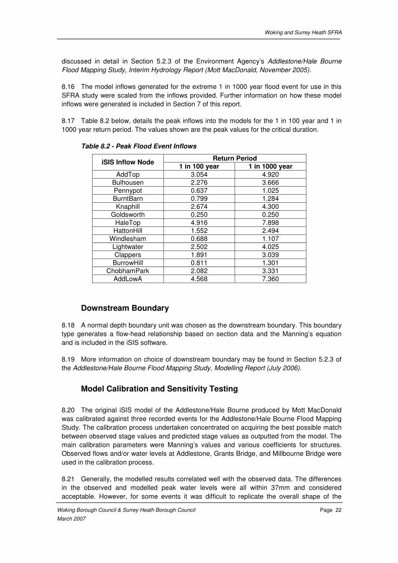
8.17 Table 8.2 below, details the peak inflows into the models for the 1 in 100 year and 1 in
1000 year return period. The values shown are the peak values for the critical duration.
Table 8.2 - Peak Flood Event Inflows
Return Period iSIS Inflow Node
1 in 100 year 1 in 1000 year
AddTop 3.054 4.920
Bulhousen 2.276 3.666
Pennypot 0.637 1.025
BurntBarn 0.799 1.284
Knaphill 2.674 4.300
Goldsworth 0.250 0.250
HaleTop 4.916 7.898
HattonHill 1.552 2.494
Windlesham 0.688 1.107
Lightwater 2.502 4.025
Clappers 1.891 3.039
BurrowHill 0.811 1.301
ChobhamPark 2.082 3.331
AddLowA 4.568 7.360
Downstream Boundary
8.18 A normal depth boundary unit was chosen as the downstream boundary. This boundary
type generates a flow-head relationship based on section data and the Manning’s equation
and is included in the iSIS software.
8.19 More information on choice of downstream boundary may be found in Section 5.2.3 of
the Addlestone/Hale Bourne Flood Mapping Study, Modelling Report (July 2006).
Model Calibration and Sensitivity Testing
8.20 The original iSIS model of the Addlestone/Hale Bourne produced by Mott MacDonald
was calibrated against three recorded events for the Addlestone/Hale Bourne Flood Mapping
Study. The calibration process undertaken concentrated on acquiring the best possible match
between observed stage values and predicted stage values as outputted from the model. The
main calibration parameters were Manning’s values and various coefficients for structures.
Observed flows and/or water levels at Addlestone, Grants Bridge, and Millbourne Bridge were
used in the calibration process.
8.21 Generally, the modelled results correlated well with the observed data. The differences
in the observed and modelled peak water levels were all within 37mm and considered
acceptable. However, for some events it was difficult to replicate the overall shape of the
Woking and Surrey Heath SFRA
Woking Borough Council & Surrey Heath Borough Council Page 23
March 2007
observed results. This was found to have little bearing on the overall results and was thus
deemed acceptable.
8.22 Comparisons of the resulting flood extents were also compared to the historical flood
maps for the 1968 and 2003 flood events. The 1968 event is understood to represent a severe
flood of at least a 1 in 100 year return period event, whilst the 2003 event was only severe in
the Hale catchment and in the reach of the Addlestone Bourne downstream of the Hale
confluence.
8.23 Further details of the calibration work carried out by Mott MacDonald are available in
Section 5.3 of the Addlestone/Hale Bourne Flood Mapping Study, Modelling Report (July
2006).
8.24 Sensitivity testing was carried out for the Addlestone/Hale Bourne model as part of the
Flood Mapping Study by Mott MacDonald. The analysis aims to adjust the parameters where
the greatest uncertainty lies, or where assumptions have been made, and examine their
impacts on peak flood levels. The main parameters tested were flow and Manning’s values,
which were adjusted by ±15% and ±10% respectively.
8.25 The results of the testing showed that the peak levels remained within ±150mm of the
original values. An increase of 15% in flow resulted in a maximum predicted stage level of
140mm in the Hale catchment. Elsewhere, the increase in values generally remained less than
50mm. An increase in Manning’s values of 10% raised the predicted stage levels by a
maximum of just 80mm. There is consequently a reasonable degree in confidence in the
model results.
8.26 Further details of the sensitivity testing carried out by Mott MacDonald may be seen in
Section 6 of the Addlestone/Hale Bourne Flood Mapping Study, Modelling Report (July 2006).
Hydraulic Modelling to Define Flood Zones
8.27 A number of simulations of the 1D iSIS models were undertaken by Mott MacDonald for
the Addlestone/Hale Bourne Flood Mapping Study and Capita Symonds for this SFRA. The
simulations aimed to produce the maximum flood extents for the 1 in 100 year and 1 in 1000
year return period flood events. Within the Study Area there are no significant defence
structures present and hence there was no requirement to modify the model from its existing
state.
8.28 The method for generating the Flood Zones and criteria agreed with the EA are detailed
below and used in the analysis:
• Zone 1 (Little or No Risk) including land on higher ground than the areas defined by Zones 2 and 3. Therefore no specific flood modelling was required to define this zone, as it can be derived by creating Zones 2 and 3.
• Zone 2 (Low to Medium Risk) was defined by the peak flood envelope of the 1 in 1000 year return period fluvial flows and a model geometry representing the current River Wey system (undefended). The 1 in 1000 year flood levels were not included in previous studies and therefore were completed by Capita Symonds as part of this SFRA. The results from these runs were extracted from iSIS and used for
Woking and Surrey Heath SFRA
Woking Borough Council & Surrey Heath Borough Council Page 24
March 2007
generation of the Flood Zone outlines as detailed in Section 10 of this SFRA report. The tabular output can be seen in the Appendix G.
• Zone 3 (High Risk) was defined by producing a peak flood envelope of the 1 in 100 year return period fluvial flows and a model geometry representing the undefended case. This model run was completed by Mott MacDonald for the Addlestone/Hale Bourne Flood Mapping Study and has not been re-run for this SFRA. The 1 in 100 year outline produced by Mott MacDonald was supplied by the EA and has been used for definition of Flood Zone 3.
8.29 Plans showing the modelled Flood Zones are included in Appendix C.
Hydraulic Modelling to Define Actual Risk
8.30 Simulations carried out by Mott MacDonald for the Addlestone/Hale Bourne Flood
Mapping Study were aimed at defining the 1 in 100 year flood outline for existing geometry.
The Actual Risk characteristics of the Study Area are defined by a peak flood envelope
produced using the 1 in 100 year return period fluvial inflows. As there are no formal raised
flood defence structures within the study area this peak flood envelope is the same for the
defended and undefended scenarios, and hence the outline produced by Mott MacDonald for
the Addlestone/Hale Bourne Flood Mapping Study has been adopted and unchanged for
definition of Actual Risk in this SFRA. The tabular output may be seen in the Appendix G.
8.31 The impacts of climate change were also assessed as part of the assessment of Actual
Risk. Climate change has been accounted for by adding on additional 20% to model inflows.
The resulting peak flood envelope is displayed with the 1 in 100 year Actual Risk envelope in
Appendix D.
8.32 The 1 in 20 year flood event has also been modelled. As discussed in Chapter 12 this
return period has been modelled to give an indication of those areas that may flood with
relative frequency. Simulations carried out for the Addlestone/Hale Bourne Flood Mapping
Study defined the 1 in 20 year flood outline for existing geometry. This outline has been
adopted for use in this SFRA.
Hydraulic Modelling to Define Residual Risk
8.33 A number of simulations of the 1D iSIS models were carried out for this SFRA with the
aim of defining the Residual Risk of flooding within the Study Area.
8.34 The assessment of Residual Risk was based on the maximum modelled flood extent
using the 1 in 1000 year flood event inflows. As previously noted there are no formal flood
defences within the Study Area and hence there was no requirement to modify the model from
its existing state. The tabular output from these model runs may be seen in the Appendix G.
8.35 The peak flood envelope associated with this Residual Risk is shown on plans in
Appendix E.
8.36 The Residual Risk of defence breach has not been assessed, as no formal raised flood
defences have been identified within the Study Area.
Woking and Surrey Heath SFRA
Woking Borough Council & Surrey Heath Borough Council Page 25
March 2007
9. OTHER SOURCES OF FLOODING
Groundwater, Surface Water and Other Sources of Flooding
9.1 A large percentage of the Study Area is currently undeveloped, therefore surface water
runoff and drainage is relatively unchanged from the Greenfield condition in the more rural
areas.
9.2 The most intensive existing development within the Study Area is predominantly in
Camberley, Lightwater, Bagshot, and Woking.
9.3 Goldsworth Park to the north west of Woking may warrant further investigation to asses
the capacity and efficiency of the lake system, and whether it is sufficient to meet current and
future requirements.
9.4 Surface water runoff from these developed areas is very likely to result in increased
water levels within the local watercourses compared to the natural catchment river levels,
although this has not been quantified, it is generally accepted that a positive drainage system
associated with development increases the peak flow rate from a development area and
therefore in the receiving watercourses. Sustainable Drainage systems can reduce this
impact.
9.5 Sustainable drainage involves controlling surface water runoff close to its origin through
the use of engineering solutions which mimic natural drainage regimes. Sustainable drainage
techniques have many benefits such as reducing flood risk, encouraging groundwater
recharge, improving water quality, and providing amenity and wildlife benefits. When being
designed site drainage schemes should aim to reduce pollution, flooding, and provide
landscape and wildlife benefits. Further information on sustainable drainage systems (SUDS)
is given below. The Environment Agency can provide further guidance on applying SUDS and
this aspect of the planning process. (Environment Agency, 2006)
9.6 The public sewer network managed by Thames Water drains surface water from urban
areas within the Study Area. All surface water within the Study Area ultimately discharges to
the Thames via the Hale Bourne, Addlestone Bourne and Wey.
9.7 Surface water flooding has not been specifically assessed as part of the Woking and
Surrey Heath SFRA. However areas recorded as having experienced surface water,
groundwater or other types of flooding in the past, have been included on a GIS layer supplied
on CD at the back of this report and can be used to give an indication of where these issues
may occur again in the future.
Sustainable Drainage Systems (SUDs)
9.8 Sustainable drainage systems endeavour to mimic the natural movement of water over
the land and aim to control runoff near its source. SUDs have a number of benefits including
reducing flood risk, improving water quality and often provide attractive features, enhancing
development quality. The European Water Framework Directive requires sustainable
management of water resources and protection of water quality. SUDs offer an integrated
approach that could play a part in delivering these requirements.
Woking and Surrey Heath SFRA
Woking Borough Council & Surrey Heath Borough Council Page 26
March 2007
9.9 As land is developed, natural drainage patterns are disrupted. In the majority of cases
development will results in an increase in the proportion of impermeable cover. Traditionally
drainage systems have removed rainfall from developments as quickly as possible. This
causes higher flow rates in receiving watercourses. Through this and the reduction in the time
it takes for rainfall to reach rivers, flooding further downstream can result.
9.10 SUDS fall into three broad groups based on their primary function:
(a) Reduce the quantity of runoff from the site (source control techniques);
(b) Slow the velocity of runoff to allow settlement, filtering and infiltration (permeable conveyance systems); and
(c) Provide passive treatment to collected surface water before discharge into groundwater or to a watercourse (end of pipe systems).
9.11 Although many SUDs techniques can provide all three elements, the advantages and
disadvantages of different surface water management techniques should be considered for
each development site. When doing this consideration should be given to the particular setting
and especially the ground conditions. Some of the benefits that may be offered by SUDS
include:
(i) protection and enhancement of water quality and biodiversity;
(ii) maintenance or restoration of natural flow regimes in streams;
(iii) protection of people and property from flooding, now and in the future;
(iv) protection of watercourses from pollution caused by accidental spillages and misconnections;
(v) they can be designed in a way that is sympathetic to their environmental setting and the needs of the community; and
(vi) they can allow natural groundwater recharge where this is considered appropriate.
9.12 SUDS can be designed in a way that is sympathetic to their environmental setting and
the needs of the community. SUDs include a wide range of techniques including permeable
pavements, green roofing, infiltration trenches, infiltration basins, filter drains, swales, filter
strips, detention basins, retention ponds, and wetlands.
9.13 Developers should consult WBC and SHBC, the Environment Agency, and sewerage
undertakers at the earliest stage of the development process to establish the best solution for
a particular site.. The Environment Agency advise that widespread adoption of sustainable
drainage system techniques would see a long-term improvement in the quality of rivers and
the reduction in flood risk. (Environment Agency, 2003).
9.14 Relevant documents, which should be consulted for further information include:
• CIRIA 522 (SUDS Design manual for England and Wales)
• CIRIA 523 (SUDS Best Practice manual)
• CIRIA 609 (SUDS – hydraulic, structural and water quality advice)

Woking and Surrey Heath SFRA
Woking Borough Council & Surrey Heath Borough Council Page 27
March 2007
• National SUDS Working Group, 2004, Interim Code of Practice for
Sustainable Drainage Systems.
• Environment Agency Thames Region – DRAFT Sustainable Drainage
Systems, A Practical Guide, October 2006
The Basingstoke Canal
9.15 The Basingstoke Canal stretches between the villages of Greywell in Hampshire and
Woodham in Surrey.
9.16 Conceived as an agricultural waterway to connect the area of North East Hampshire
with the London markets, the Basingstoke Canal took seven years to complete with
construction starting in 1787 and being completed in 1794. The canal stretches for a distance
of 32 miles (51km) incorporating 29 locks to raise the canal from the River Wey up to the
plateau in Hampshire which was 245ft (75m) above sea level, a tunnel at Greywell which was
1200 yards (1097m) long and took the canal through the hill under Butterwood.
9.17 The Basingstoke Canal is what is known as a contour canal. This means that as far as
possible the canal is built around the side of the hills on a contour maybe 5m above the
normal ground level. Where the canal crosses a valley to pick up the next hill, it was raised on
an embankment. Where a large hill blocked the path of the canal and it was not economical to
follow the contour around the hill then the hill was excavated to form a cutting which carried
the canal through the hill in a man made valley. If the hill was too high to form a cutting, then
as a last resort, the canal would be carried through the hill in a tunnel. Where the local ground
level starts to drop away, the canal is carried on an embankment of steadily increasing height
until it approaches the 5m height at which time a lock is inserted into the system to lower the
canal by 2 or 3 m to the next contour line. This system of following contours eventually brings
the canal to the same level as the Wey Navigation at New Haw near Byfleet in Surrey. Over its
32 mile length, it remains level for the 15 miles from Greywell to Aldershot in Hampshire and
then drops by approx 60m over the next 17 miles to the Wey Navigation in Surrey. When the
canal was built it was only required to excavate a ledge around a hill, the spoil was then piled
up on the downhill side of the excavation to form a bank to keep the water in, and hence total
excavation and haulage distances were reduced.
9.18 By 1964, the canal was almost completely derelict as The New Basingstoke Canal
Company had allowed maintenance issues to mount. On September 15th 1968, due to its
neglect and following a period of exceptionally heavy rain, the canal burst its banks in two
places, an event which led to the restoration of the Basingstoke Canal. The canal is now fully
navigable, and connects to the River Wey Navigation, which in turn joins the River Thames.
9.19 After the realisation that the canal could not be managed as two halves, both
Hampshire County Council and Surrey County Council, have handed control of management
and maintenance of the Basingstoke Canal to the Basingstoke Canal Authority.
Interaction of the Canal with Other Watercourses
9.20 The Basingstoke Canal passes through the study area near Frimley Green, Mytchett,
and Woking. In addition to the Basingstoke Canal the Wey navigation also passes through the
south of the study area. The flood risk from the Wey navigation is not significant as the canal
is not raised above ground level like the Basingstoke Canal and is also located for most of its
Woking and Surrey Heath SFRA
Woking Borough Council & Surrey Heath Borough Council Page 28
March 2007
length within the fluvial floodplain of the River Wey. The Wey navigation is discussed in more
detail within the Woking and Guildford SFRA.
9.21 Within the study area the Basingstoke Canal interacts with both watercourses classified
as ‘Main River’ and drainage ditches. These include the Rive Ditch (enmained April 2006) and
the Brookwood Lye (defined by the EA as ordinary watercourses). Figures H1-H6 in
Appendix H (provided by the Basingstoke Canal Authority) highlight the areas that would be
liable to flooding in event of an embankment breach or culvert failure, the mechanisms behind
these flooding problems are outlined below:
Breach of embankment
9.22 In the Study Area, the Basingstoke Canal passes through low-lying land, which at some
sites was originally marshland and has been historically drained for development.
Consequently the land particularly to the south of the canal has extensive drainage ditch
networks in place. In the event of the canal breaching its banks, these drainage ditches would
back-up or may have a surcharge effect and waterlog the surrounding areas causing flooding.
This will affect drainage and possibly result in flooding remote from the canal (Refer Figures
H1-H6 in Appendix H). A breach at sites 2 to 10 (refer Appendix H) would possibly result in
a discharge of very large volumes of water into the Rive Ditch.
Culvert Failure
9.23 There are many culverts under the Basingstoke Canal within the Study Area. These
culverts enable the canal to pass over many minor watercourses. A blockage or collapse
(resulting in blockage) of any of these culverts could result in extensive flooding and could also
surcharge the land drainage system. The sites at risk of culvert failure include sites 8, 10 and
13.
Bypassing
9.24 It is possible that if the canal were to breach its embankments at certain points within
the Study Area, floodwaters could re-join the canal further downstream. At site 20 (refer
Appendix H), this possibility could result in further bank failure further downstream.
Flood Risk Associated with a Breach of the Canal
9.25 As discussed in Section 9.16 the contour style construction of the Basingstoke Canal
requires that a ledge be excavated around the hill, for which the spoil is then placed on the
downhill side of the excavation to form a bank to retain water. This form of construction is
considered low risk if construction is to currently accepted standards - spoil forming water
retaining embankments ‘keyed’ into the hillside, is properly compacted in layers, has a well
drained core to prevent saturation and potential slippage, and has a slope constructed to
match angle of repose of the material used. It has been advised that the Basingstoke Canal
embankment is not ‘keyed’ into hill side, compaction is only a result of gravity over the past
200 years, there is no core drainage, and the embankments have slopes which exceed
currently accepted standards. These factors make the Basingstoke Canal embankment
inherently prone to failure.
Woking and Surrey Heath SFRA
Woking Borough Council & Surrey Heath Borough Council Page 29
March 2007
9.26 As mentioned in Section 9.17 there are historic records of the canal breaching its
banks. Due to a lack of routine maintenance and a period of exceptionally heavy rainfall, the
Basingstoke Canal breached its banks in two places on September 15th 1968. The first
breach was at Farnborough and the second at Aldershot. The Aldershot breach caused
limited damage, but did leave a substantial opening in the Ash embankment. Should the
breach occur today it has potential to cause substantial damage, however the Aldershot
section of the canal is outside of the study area for this SFRA so will not be considered in any
more detail.
9.27 In addition to increased water levels within the canals as a direct effect of excessive
rainfall, flood risk has been increased by large amounts of surface water runoff that have been
diverted from road drains, camp parade grounds and railway line drainage into the canal
during its working life.
9.28 The flood risk posed by the Basingstoke Canal has been considered within the Weir
Protocols (instructions on the operation of the canal weirs held by the Basingstoke Canal
Authority) and draining down procedures produced by The Basingstoke Canal Authority. There
are three protocols in place for the Basingstoke Canal; Summer, Winter and Emergency (or
server weather) Protocols.
9.29 Summer Weir Protocols ensures that the adjustable sections of weirs in the Surrey
section of the canal will be restored to their normal working heights to maintain full water levels
in the canal. Winter Weir Protocols require the adjustable sections of weirs on the Surrey
section of the canal to be reduced in height by 100mm to establish a flow on the canal towards
the weirs. In the event of extreme rainfall or a canal emergency, the protocol states that the
canal should be isolated into discrete sections, which can then be controlled via the use of
sluices. In the case of a dire emergency it is advised in the protocol that the sluices are fully
drawn to allow canal water to drain quickly. Although this would result in an immediate relief
of flood risk to the area, it is likely that this action could cause flooding problems elsewhere in
the vicinity. In such an event the Environment Agency would be informed of this magnitude of
weir movement.
9.30 It should be noted that flood risk from the Basingstoke Canal is considered a Residual
Risk and in accordance with PPS25 new developments will be required to manage this risk but
may not be required to fully mitigate this risk. Therefore, those sites identified on Figures H1-6
in Appendix H as being at risk of flooding from a breach of the Basingstoke Canal or culvert
failure are still considered suitable for most development types.
9.31 Locations where sources of flooding discussed in this chapter have been identified are
described in Chapter 12.
Woking and Surrey Heath SFRA
Woking Borough Council & Surrey Heath Borough Council Page 30
March 2007
10. MAPPING OF FLOOD EXTENTS
Floodplain Topographic Survey
10.1 Topographic survey of the floodplain was received from the Environment Agency. This
consisted of survey data at modelled cross-section locations and photogrammetry for the
entire study area. Section 4 of the Addlestone/Hale Bourne Flood Mapping Study, Modelling
Report (Mott MacDonald, July 2006) gives details of survey data that was available for that
study, which was also made available for this SFRA.
10.2 The photogrammetry data has undergone a series of checks to ensure consistency,
quality and completeness. It should be noted that the data was collected in 1996 and as such
does not include changes to the topography (such as land raising as a result of new
developments) since that date.
10.3 To maintain consistency with the Addlestone/Hale Bourne Flood Mapping Study, the
Digital Terrain Model (DTM) created by Mott MacDonald and used in the generation of flood
extents, was adopted and unchanged for this SFRA. This DTM had been generated purely
from the photogrammetry provided.
10.4 It should be noted that this level of accuracy is considered suitable for a SFRA, however
is not considered suitable for more detailed studies into flood risk at specific sites and those
preparing detailed FRA for specific sites are advised to obtain more accurate topographic data
where possible.
Methodology
10.5 Flood extents for the 1 in 100 year and 1 in 100 year + 20% (climate change allowance)
were produced by Mott MacDonald for the Addlestone/Hale Bourne Flood Mapping Study and
were provided to Capita Symonds electronically in GIS formats by the Environment Agency for
use in this study. These flood outlines have been adopted unchanged for this SFRA. The 1 in
1000 year flood was not modelled as part of the Addlestone/Hale Bourne Flood Mapping
Study and therefore required modelling and mapping for this SFRA.
10.6 Model results from the 1 in 1000 year simulations (results included in Appendix G)
were used to generate flood extent maps for the Addlestone/Hale Bourne catchments.
10.7 The mapping of the 1 in 1000 year extent was carried out manually based on the results
generated in iSIS. The key steps in this procedure are outlined below:
• Generate a contoured DTM from the photogrammetry data provided;
• Using the cross-section locations as used by Mott MacDonald for the Addlestone/Hale Bourne Flood Mapping Study, and match these cross-sections with the corresponding maximum stage level as outputted from iSIS;
• Ensure consistency with the flood widths as outputted in iSIS and the 1 in 100 outlines generated by Mott MacDonald for the Addlestone/Hale Bourne Flood Mapping Study

Woking and Surrey Heath SFRA
Woking Borough Council & Surrey Heath Borough Council Page 31
March 2007
10.8 For further details on the mapping procedures used in the Environment Agency’s Flood
Mapping Study for the generation of the 1 in 100 and 1 in 100 + 20% extents, refer to Section
7 of the Addlestone/Hale Bourne Flood Mapping Study, Modelling Report (Mott MacDonald,
July 2006).
Recommendations
10.9 The produced outlines are based on model predicted flood levels for given flood
conditions. These extents represent an assessment of the Addlestone/Hale Bourne catchment
utilising the best available data. It is important to take into account the limitations of the data in
which these outlines have been generated, particularly the photogrammetry data. If it is known
that new developments have significantly raised or lowered land within the catchment, then
this should be investigated and the flood extents modified accordingly.
10.10 Furthermore, the flood extents will need to be continually updated in the future to
account for new developments as these will affect flows and water levels within the catchment.
Woking and Surrey Heath SFRA
Woking Borough Council & Surrey Heath Borough Council Page 32
March 2007
11. UNCERTAINTIES IN FLOOD RISK ASSESSMENT
11.1 When assessing risk, the impact of uncertainties associated with the predictions of the
hazard and the consequences should be recognised and appreciated so informed decisions
can be made.
11.2 The strategy for risk management requires that all phases of the planning and
implementation process are fully co-ordinated. The level of detail on flood risk assigned to
particular proposals will be limited by the information available at the time of the submission of
respective planning applications. It should be noted that the outputs of the SFRA are only as
good as the data inputs.
11.3 The Woking and Surrey Heath SFRA should be kept as a live document, reviewed and
updated as necessary as the best available information is improved or the inherent
uncertainties identified are reduced. In particular it should be noted that an improvement in
topographic data may result in a change in the flood extents presented in this SFRA. The
implementation of measures or strategic options may change the Actual Risk, Residual Risk
and Flood Hazard.
Generic Risks and Uncertainties
11.4 Following a review of the available baseline information it has been possible to identify
the following principal elements that contribute to the uncertainty in the quantification of the
flood risk in the Study Area:
(i) There is a lack of flow gauging records within the Addlestone/Hale Bourne Catchment, and as such flows were predicted using the FEH Rainfall Runoff Method;
(ii) The impact of global warming could result in a 20% increase in the magnitude of predicted peak flow contributions to the watercourses within the Study Area;
(iii) Best available topographic data was used in production of the flood extents. However the accuracy of this data has a bearing on the uncertainty and accuracy of the flood mapping produced; and
(iv) Not all watercourses in the Study Area have been specifically modelled for this SFRA. Quantification of flood risk on these watercourses is subject to greater uncertainty.
11.5 Other future uncertainties that will affect the estimate of flood risk in the Woking and
Surrey Heath SFRA Study Area during the course of the planning and implementation of the
Woking and Surrey Heath development options include (but are not limited to):
(i) The outcomes of the Environment Agency’s Hale and Addlestone Bourne Strategy Inception Report, which it is anticipated should be completed in December 2006;
(ii) The outcomes of the Thames CFMP;
(iii) Change to the upstream catchment or revision to inflows
Woking and Surrey Heath SFRA
Woking Borough Council & Surrey Heath Borough Council Page 33
March 2007
(iv) Changes to the Study Area; and
(v) Revision of climate change predictions.
11.6 It can be seen that there is a wide envelope of ‘fixed base’ uncertainty attached to the
estimation of risk. It should be accepted that adopting a precautionary approach throughout
the process could either result in the implementation of excessive defence proposals that
envisage an event that is unlikely to be witnessed or the specification of defences at locations
where the standard of protection is compromised as a consequence of provision of revised
data. Different standards of risk may also be assigned to adjacent sites simply as a
consequence of the timing of the application and the values obtained from the best available
information at a particular time. To be consistent with current guidance a precautionary
approach is adopted together with recognition of the need to review the results as
circumstances change.
11.7 It is probable that development proposals will be a focus for the collection of better data
in the future and the catalyst for commissioning studies that lead to a reduction in the
uncertainty in the magnitude or frequency of influential parameters, i.e. the improvement of
hydrometric data, or completion of new hydraulic models on previously unmodelled reaches.
A prudent response is to use the best available data at each stage of the planning process
and prepare proposals that are respectively precautionary in accordance with the advice in
PPS 25 and flexible with respect to uncertainty. The need to prepare stand alone Flood Risk
Assessments in support of the submission of particular planning applications will serve to
highlight information that would be the trigger for a review of the Woking and Surrey Heath
SFRA.
11.8 The Woking and Surrey Heath SFRA is based on information that will inevitably be
amended by better data, changes in the baseline condition due to development and changing
institutional and policy conditions. To be robust and able to withstand challenge in the planning
process there is a need to ensure the Woking and Surrey Heath SFRA reflects conditions at
the time particular evaluations are made. Failure to maintain the SFRA may reduce the
effectiveness of flood risk management measures; delay plan making and development
processes; and potentially lead to the neglect of flood risk considerations and the failure to
capture strategic responses and interventions.
11.9 The Planning Policy Teams at WBC and SHBC will have the prime responsibility for
managing and maintaining this SFRA. The SFRA will be reviewed annually as part of the
annual monitoring report.
Woking and Surrey Heath SFRA
Woking Borough Council & Surrey Heath Borough Council Page 34
March 2007
12. STRATEGIC FLOOD RISK ASSESSMENT
Introduction
12.1 A Strategic Flood Risk Assessment (SFRA) is the term currently used for a flood risk
assessment undertaken to inform the spatial planning process at the local scale2. A SFRA is
not a spatial plan or a planning policy, rather it informs the planning process of the present,
and likely future, flood risks. It is part of an iterative, whole-life process and should not be
considered in isolation from the flood risk management requirements resulting from the spatial
plan. The SFRA is a means of applying a risk-based search sequence as advocated by
PPS 25 in the land use planning and development control process. The SFRA may be used to
apply the Sequential Test and as a starting point for applying the Exception Test to land
allocations.
12.2 A SFRA, by providing information on flood risk, also enables Local Planning Authorities
(as well as those involved in strategic planning and decision-making) to identify and designate
those areas which are more or less suitable for particular types of different development
following a risk-based sequential test3. The SFRA can be used to inform:
• Regional Spatial Strategies;
• Local Development Frameworks;
• Area Action Plans
• Sustainability Appraisals
• Development Control; and
• Flood Risk Management.
Justification and Statutory Responsibilities
12.3 National planning guidance notes PPS 11 and PPS 12 identify that guidance given in
PPG 25 (now superseded by PPS 25) should be used when considering flood risk. The thrust
of Government planning guidance is that new development should be located and designed so
that the overall risks of flooding are reduced and that allowance should be made in a
precautionary fashion for climate change impacts, particularly in areas exposed directly to ‘sea
level rise’ effects, or in areas where increased fluvial flows could be experienced in the future.
PPS 25 includes these concepts by advising the adoption of a strategic approach with the
objectives of minimising the exposure of development allocations to flood risk, using a
sequential search sequence. In addition to Government guidance, the EA has policies for
consideration in respect of development affected by flood risk.
12.4 The SFRA is the primary mechanism by which the strategic planning process is
informed of the implications of flood risk and is strategic by virtue of the fact that it is spatially
extensive and considers the potential impact of future climate change effects.
12.5 Decision-making on land use, development form, essential services, emergency
procedures and strategic flood risk management solutions can be developed from information
2 Flood Risk Assessment Guidance for New Development: Phase 2, FD2320/2
3 Planning Policy Statement 25: Development and Flood Risk
Woking and Surrey Heath SFRA
Woking Borough Council & Surrey Heath Borough Council Page 35
March 2007
from the Woking and Surrey Heath SFRA. The process enables the vulnerability of particular
types of development to be considered in the context of flood risk and potential hazards. This
may then influence the spatial distribution of particular development types, with the aim of
placing the most vulnerable development in the least hazardous areas and the least
vulnerable development in areas that are subject to greatest risk. This is important since the
consequences of flood risk affect the social, economic and environmental sustainability of the
developments within the Study Area. The outputs from the process can also be used to
specify Development Control advice, such as guidance on the ‘built form’ of development so
that development can be implemented in a way that minimises consequences in the event of a
flood. Finally it can identify and evaluate the efficiency of strategic interventions that could
contribute to a reduction in flood risk.
12.6 The objective of the Woking and Surrey Heath SFRA is to supply guidance that informs
those responsible for decision-making in a context that is demonstrably compatible with the
guidance given in PPS 25.
12.7 The Woking and Surrey Heath SFRA relies on the Risk Evaluation Procedure to identify
Flood Zones, predict Actual Flood Risk, identify Residual Risk and examine Flood Hazard, as
described in Appendix A and the relevant guidance in PPS 25. The predictions of Flood
Zones and Actual Flood Risk provide evidence to assist in demonstrating that there are no
reasonable development options available in a lower-risk category, consistent with all other
sustainable development objectives. This process of allocation therefore meets the
requirements of a sequential risk based assessment as defined in PPS 25 and can also
identify strategic responses that may deliver a long term reduction in flood risk.
Approach
12.8 In keeping with the guidance in PPS 25 there is a need to adopt the following staged
Risk Evaluation Procedure to the sequential examination of flood risk, this four step procedure
is outlined in greater detail in the figure shown in Appendix A:
• Stage 1 Flood Zones - To investigate the extent of the Flood Zones as
described in Table D.1 of PPS 25.
• Stage 2 Actual Risk - To assess the actual level of flood risk taking account of
man made structures and any defences or features not included in the Flood
Zones.
• Stage 3 Residual Risk - To examine the Residual Risk posed by an event
more severe than that for which particular flood mitigation measures or spatial
planning responses have been designed.
• Stage 4 Breach Hazard - To examine the risk associated with the failure of any
relevant man made structures or flood protection works.
12.9 It would be normal to include an assessment of the risks of a flood defence breach as
part of Stage 4. However due to the absence of formal raised flood defences on the main
rivers within the study area this Stage has only considered the risk of canal breach.
12.10 It is intended that all current and subsequent development plans and planning
applications within the study area refer to and take account of the results from the Woking and
Woking and Surrey Heath SFRA
Woking Borough Council & Surrey Heath Borough Council Page 36
March 2007
Surrey Heath SFRA. As stated earlier in this document, the Woking and Surrey Heath SFRA is
considered a live document based upon the existing conditions at January 2007 and there will
be a need in the future to review the Woking and Surrey Heath SFRA such that it takes
account of all the best available information at the time particular planning decisions are taken.
12.11 The Woking and Surrey Heath SFRA facilitates the delivery of a suite of co-ordinated
responses that will deliver sustainable development and long term reduction in flood risk. This
can only be achieved if a commitment is made to the appropriate long term delivery of
strategic goals. The suite of responses that the Woking and Surrey Heath SFRA makes
available includes:
(i) Influencing development allocation through the provision of Strategic Planning Guidance;
(ii) Identification of strategic interventions that contribute to flood risk reduction;
(iii) Influencing Development Control; and
(iv) Identification of emerging planning procedure.
STAGE 1 – Flood Zone Review
12.12 Flood Zones are defined in Table D.1 of PPS 25 reproduced in Appendix A. It is
important to recognise that the basic Environment Agency Flood Zone maps, as represented
on the EA website, do not necessarily describe an actual level of flood risk since they are
derived on the basis of a broad scale topography which often does not include important
features such as flood defences, man made topography, such as road and rail embankments,
and hydraulic structures, such as bridges and culverts, all of which have a significant effect on
the spatial distribution of flood hazard.
12.13 Within the Woking and Surrey Heath SFRA the EA Flood Zones have been revised
based on more detailed information where this was available. For the purposes of modelling
Flood Zones within the SFRA it would be normal to remove all flood walls and fixed defences
as defined by the EA, however structures of this type are largely absent from the Woking and
Surrey Heath Study Area. Conveyance structures such as flood relief channels and culverts
remain in the baseline model. The Flood Zone maps in this SFRA can be used to inform a
risk-based search sequence. In the case of the Woking and Surrey Heath SFRA the absence
of formal flood defences has meant that the Flood Zone extents can be taken to be
representative of Actual Risk and Residual Risk flood extents. The Actual and Residual risk
maps provide additional information on flood depths and the distribution of risk within the
defined flood zones as well as information on the effects of climate change.
12.14 Flood Zone boundaries are defined by water levels associated with a defined probability
of occurrence. The Flood Zones for the Woking and Surrey Heath SFRA are based primarily
on detailed hydraulic modelling of the Addlestone and Hale Bourne catchment. This provides
an improved level of information on the baseline flooding situation.
12.15 Figure 3.1 shows a graphical definition of the Flood Zones.
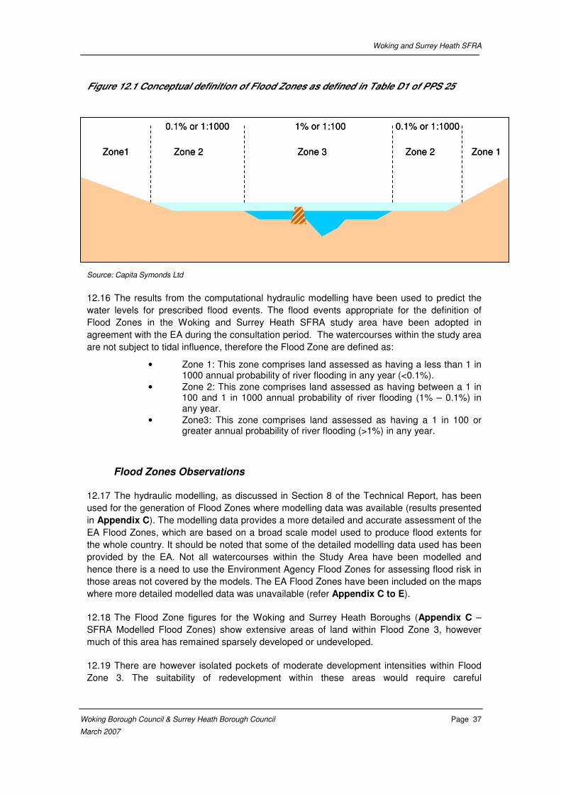
Woking and Surrey Heath SFRA
Woking Borough Council & Surrey Heath Borough Council Page 37
March 2007
Figure 12.1 Conceptual definition of Flood Zones as defined in Table D1 of PPS 25
Source: Capita Symonds Ltd
12.16 The results from the computational hydraulic modelling have been used to predict the
water levels for prescribed flood events. The flood events appropriate for the definition of
Flood Zones in the Woking and Surrey Heath SFRA study area have been adopted in
agreement with the EA during the consultation period. The watercourses within the study area
are not subject to tidal influence, therefore the Flood Zone are defined as:
• Zone 1: This zone comprises land assessed as having a less than 1 in 1000 annual probability of river flooding in any year (<0.1%).
• Zone 2: This zone comprises land assessed as having between a 1 in 100 and 1 in 1000 annual probability of river flooding (1% – 0.1%) in any year.
• Zone3: This zone comprises land assessed as having a 1 in 100 or greater annual probability of river flooding (>1%) in any year.
Flood Zones Observations
12.17 The hydraulic modelling, as discussed in Section 8 of the Technical Report, has been
used for the generation of Flood Zones where modelling data was available (results presented
in Appendix C). The modelling data provides a more detailed and accurate assessment of the
EA Flood Zones, which are based on a broad scale model used to produce flood extents for
the whole country. It should be noted that some of the detailed modelling data used has been
provided by the EA. Not all watercourses within the Study Area have been modelled and
hence there is a need to use the Environment Agency Flood Zones for assessing flood risk in
those areas not covered by the models. The EA Flood Zones have been included on the maps
where more detailed modelled data was unavailable (refer Appendix C to E).
12.18 The Flood Zone figures for the Woking and Surrey Heath Boroughs (Appendix C –
SFRA Modelled Flood Zones) show extensive areas of land within Flood Zone 3, however
much of this area has remained sparsely developed or undeveloped.
12.19 There are however isolated pockets of moderate development intensities within Flood
Zone 3. The suitability of redevelopment within these areas would require careful
Zone1 Zone 2 Zone 3 Zone 2 Zone 1
0.1% or 1:1000 1% or 1:100 0.1% or 1:1000
Zone1 Zone 2 Zone 3 Zone 2 Zone 1
0.1% or 1:1000 1% or 1:100 0.1% or 1:1000
Woking and Surrey Heath SFRA
Woking Borough Council & Surrey Heath Borough Council Page 38
March 2007
consideration given the high risk of flooding. An assessment of the risk to these areas is
covered in more detail in STAGE 2 – Assessment of Actual Risk.
12.20 Flood Zone 2 covers a wider area outside Flood Zone 3. In the upper part of the
catchment Flood Zone 2 is significantly larger than Flood Zone 3; however in the lower part of
the catchment it is not substantially wider than Flood Zone 3. The areas of particular note,
where Flood Zone 2 is much larger than Flood Zone 3 include Goldsworth Park, land south of
Chobham, and Penny Pot.
12.21 Although the floodplain areas within the Study Area are generally sparsely developed
there are a number of transport links within the floodplain considered at high risk of flooding.
12.22 Accordingly it can be concluded that:
(i) Generally existing development is at limited risk of flooding within the study
area (particular exceptions noted in Stage 2)
(ii) The Flood Zones should be taken into consideration as part of the Woking and
Surrey Heath Development Frameworks, and by Development Control,
ensuring that vulnerable land uses (including residential and essential
infrastructure) are kept outside high risk areas wherever possible.
(iii) Future development within Flood Zones 2 and 3 should take into consideration
the potential to alter the Flood Zones via diversion, obstruction or increasing
peak flow rates, thus increasing flood risk.
12.23 For further information on the flood risk associated with Flood Zone 2 refer to STAGE 3
– Assessment of Residual Risk. For further information on the flood risk associated with
Flood Zone 3 refer to STAGE 2 – Assessment of Actual Risk below.
STAGE 2 – Assessment of Actual Risk
Introduction
12.24 PPS 25 advises Local Planning Authorities to give appropriate weight to information on
flood-risk and how it might be affected by climate change in preparing development plans and
considering individual proposals for development. Such guidance is equally applicable to all
stakeholders, authorities and organisations involved in strategic planning and decision making.
12.25 The sequential risk-based approach is based on the premise that land use decisions
are based on the Actual Risk and should take account of:
(i) the area at risk from flooding;
(ii) the probability of it occurring, both now and over time;
(iii) the extent and standard of any existing defences and their effectiveness over
time;
(iv) the likely depth of flooding;
Woking and Surrey Heath SFRA
Woking Borough Council & Surrey Heath Borough Council Page 39
March 2007
(v) the rates of flow likely to be involved;
(vi) the likelihood of impacts to other areas, properties and habitats;
(vii) the effects of climate change; and
(viii) the nature, vulnerability and currently expected lifetime of the development
proposed and the extent to which it is designed to deal with flood risk.
12.26 Stage 2 of the SFRA assesses the Actual Risk to areas within the SFRA area.
Although the basic assessment is related to the 1 in 100 year flood outline (which is the same
as the modelled Flood Zone 3 in Stage 1), Stage 2 also considers the impacts of climate
change, which can be expected to increase the risk of flooding over the development plan
lifetime. Stage 2 also considers the distribution of flood hazard (based on flood depth) within
Flood Zone 3 and provides information on the extent of the Functional Floodplain.
12.27 The probability of flooding, both now and over time has been assessed using the
relevant probabilities of flows described in Table D1 of PPG 25, where necessary adjusted to
allow for future trends driven by potential global warming impacts. For the purposes of this
study flows were increased by 20% to assess the possible future impacts of climate change.
12.28 In addition to this there is also a need to consider the Functional Floodplain. This is
discussed further in section 3.34. The Functional Floodplain comprises land where water has
to flow or be stored in times of flood. SFRAs identify this Flood Zone as land which would flood
with an annual probability of 1 in 20 (5%) or greater in any year or is designed to flood in an
extreme (0.1%) flood, or at another probability to be agreed between the LPA and the
Environment Agency, including water conveyance routes.
12.29 The flood extents (1 in 20, 1 in 100 and 1 in 100+ 20%) for the Actual Risk scenarios
are provided in Appendix D.
12.30 Consideration should also be given to flooding from other sources. A CD containing a
GIS layer of areas historically recorded as flooding from sources other than fluvial has been
included at the back of this report. This information should be consulted to inform planners and
developers of flood risk from other sources. The information provided indicates areas where
flooding has been recorded in the past. It aims to provide additional information based on that
currently available, but does not provide an absolute listing. Areas or roads recorded as
flooding are mainly within Woking, Byfleet, Camberley, Frimley, Bagshot, Lightwater, and
Chobham but also include Mytchett, Windlesham, Bisley, West End and Send.
12.31 As the data available on other sources of flooding is not complete, does not give
comprehensive coverage, and is of varied quality, it should be used as a trigger for further
investigation at development sites affected.. The geology of the study area is described in
Section 5 of Volume 2 – Technical Report. Within the Addlestone\Hale Bourne catchment the
geology is a combination clay, sand, and gravels, the later two being where groundwater
flooding is most likely.
Woking and Surrey Heath SFRA
Woking Borough Council & Surrey Heath Borough Council Page 40
March 2007
Actual Risk Observations
12.32 To aid in the assessment of Actual Risk Flood Hazard Maps have been produced.
These maps show the distribution of flood depth during a 1 in 100 year flood event, and can
be seen in Appendix F. It should be noted that these Flood Hazard Maps have been
generated using the supplied topographic data. This data is based on Photogrammetry
collected in 1996. Due to the age of this data it may not provide an accurate representation of
the current topography. Therefore these maps should be considered indicative only, and not
necessarily representative of the true flood depths in a 1 in 100 year flood event.
12.33 The results of the flood risk predictions can be summarised as follows:
5% annual probability (1 in 20 year return period) flow
12.34 In accordance with PPS 25 consideration should be given to development deemed to
be in the Functional Floodplain. In line with PPS 25, all development should be kept outside of
the Functional Floodplain, with the exception of certain ‘water compatible’ land uses (e.g.
recreational and conservation uses), as well as essential transport/utilities infrastructure that
have no viable alternative location. The exception test must be passed for essential
infrastructure developments to take place in this zone. The Functional Floodplain zone
comprises land where water has to flow or be stored in times of flood. For the purpose of this
SFRA the 1 in 20 year return period flood outline defines those areas which may be acting as
Functional Floodplain.
12.35 It should be noted that information on the 1 in 20 year floodplain could only be provided
where detailed hydraulic modelling has been carried out. Modelling of the Blackwater and a
number of tributaries within the Addlestone and Hale Bourne catchment has not been
completed as part of this SFRA and EA Flood Zones have been used to assess risk in this
area. As no sub-division of the EA Flood Zone 3 information is available, it was not possible to
consider the extent of the Functional Floodplain in these areas. However where detailed Flood
Risk Assessments for specific sites are completed within Flood Zone 3, and there is currently
no information on the 1 in 20 year floodplain, it is recommended that the extent of the
Functional Floodplain is assessed. This may be through further modelling, or if this is not
possible, information on historic flooding may be of assistance in defining the Functional
Floodplain
12.36 The majority of flooding from the 1 in 20 year return period within the Study Area is
limited to open space and rural or semi-rural areas. The results of hydraulic modelling
demonstrate the following more developed areas may be at risk from a 1 in 20 year return
period flood event:
• Properties between Bridge Road (B3029) and Guildford Road in Bagshot are at risk of fluvial flooding from the Hale Bourne.
• Parts of Riverside Avenue in Lightwater are at risk of fluvial flooding.
• Land and property west of the High Street, to the north of the A319 and around Grants bridge at Chobham
• Land and property between the river and Sandpit hall Road at Rothwell Nursery.

Woking and Surrey Heath SFRA
Woking Borough Council & Surrey Heath Borough Council Page 41
March 2007
• Land and Property at Philpot Lane west of Fairoaks Airport.
1% annual probability (1 in 100 year return period) flow
12.37 The majority of flooding within the Study Area is limited to open space and rural or
semi-rural areas. A few developed areas are at high risk from flooding. The results of hydraulic
modelling demonstrate that in addition to those listed above the following areas are presently
at risk from a 1 in 100 year return period flood event:
• Properties in Bagshot between Bridge Road (B3029) and the railway, and between the railway and Freemantle Road. Flooding is concentrated to the left bank of the Hale Bourne and flood depths are generally below 0.5 m.
• Properties in Lightwater, including properties on Riverside Avenue, The Willows, and Birchwood Drive. Flood Depths are generally below 0.75 m. Possible flooding mechanisms include flow constriction at culverts.
• Land, roads, and property in Chobham south of the A319 and around the High Street flood from the Hale Bourne. Flooding also occurs at Grants bridge from the Addlestone Bourne. Flood depths are generally below 0.5 m.
• Land and property between the river and Sandpit Hall Road at Rothwell Nursery. The floodplain is wide here with flood depths generally less than 0.5 m.
• Land and Property at Philpot Lane west of Fairoaks Airport. This area is upstream of the confluence between the Hale and Addlestone Bournes.
• The flood extent at Mimbridge encroaches into the gardens of properties. Flood depths are less than 0.3 m.
• Property south of the A3046 and a school north of the road is partially within the flood extent. The flood extent extends between the Hale and Addlestone Bournes. The flood depths south of the road and near the school are generally less than 0.25 m.
• A few properties are at risk on Epsom Close, north of Camberley and at York Town between the stream and Stanhope Road. Flooding here originates from the Wish Stream. This is based on EA Flood Zones.
• Gas Holder Station and Industrial units adjacent to the A331 are at risk from the Blackwater.
• Frimley Business Park, Albany Park Industrial Estate, Lyon Way Industrial Estate, and property in Frimley Village to both the north and south of the High Street are within EA Flood Zone 3.
12.38 For further details on predicted flood depths refer to Appendix F.
1% annual probability (1 in 100) flow + 20% increase in magnitude combined
Woking and Surrey Heath SFRA
Woking Borough Council & Surrey Heath Borough Council Page 42
March 2007
12.39 Current predictions of climate change suggest river flows may increase by as much as
20% in extreme events over the next 50 years. It is therefore very necessary to consider how
flood risk may change and potentially increase in coming years.
12.40 As expected there is an extension of the floodplain in some areas as a result of
increased flows, however generally flooding mechanisms within the Study Area remain the
same. Due to the generally well defined river floodplains, which exists on many of the
watercourses within the Study Area, the increase in flows resulting from climate change has
had only a minimal impact on flood extent in many areas. The spatial impacts on Actual Flood
Risk associated with climate change within the Study Area are shown in Appendix D.
Modelling of the Blackwater has not been completed and EA Flood Zones are being used to
assess risk. Therefore it was not possible to consider the impacts climate change in the
Camberley area.
12.41 The most notable areas of increased flood extent resulting from potential climate
change are as follows:
• The number of properties affected in Bagshot increases, particularly to the east.
• Although the flood extent not much greater in Lightwater, it does incorporate a number of additional properties.
• A few additional properties shown at risk at the Nurseries south of West End on the Guildford Road.
Woking and Surrey Heath SFRA
Woking Borough Council & Surrey Heath Borough Council Page 43
March 2007
STAGE 3 – Assessment of Residual Risk
Introduction
12.42 In recognition that flood management and mitigation measures including appropriate
spatial planning in relation to Actual Risk cannot eliminate flood-risk, there is a need to be
aware of the Residual Risk generated by an event more severe than that for which particular
flood management/planning and mitigation measures have been designed. Consideration of
the Residual Risk is a key requirement of Flood Risk Assessments as defined in Annex E and
Annex G of PPS25.
12.43 The Stage 3 – Assessment of Residual Risk provides information on the flood risk
associated with extreme events within the Study Area. The Residual Risk will be assessed for
the same return period for which Flood Zone 2 was based (1 in 1000 year return period). The
assessment of Residual Risk would usually differ from the Flood Zone 2 assessment due to
the inclusion of an assessment of the performance of any existing flood defences. Due to the
absence of formal raised flood defences within the Woking and Surrey Heath Study Area, the
assessment of Residual Risk from fluvial sources is the same as that for Flood Zone 2.
12.44 The flood extents for the Residual Risk scenario are available in Appendix E.
Residual Risk Observations
12.45 The results of the residual hazard analyses can be summarised as follows:
0.1% annual probability (1 in 1000 year return period) flow
12.46 As expected the Residual Risk floodplain is significantly larger than the Actual Risk
floodplain in some areas as a result of increased flows, however generally flooding
mechanisms within the study area remain the same. Where there are informal defence
structures or infrastructure, these may impact upon the residual risk. Due to the generally well
defined river floodplains, which exist on many of the watercourses within the study area, the
increase in flows associated with the Residual Risk flood event has had only a minimal impact
on flood extent in many areas within the Study Area. The flood extents associated with the
Residual Risk flood event are shown in Appendix E.
12.47 Much of the flooding resulting from the Residual Risk flood event within the study area
is limited to open space and rural or semi-rural areas. In accordance with PPS 25, highly
vulnerable land uses should be avoided in areas potentially susceptible to Residual Flood
Risk, unless the exception test is passed.
12.48 As discussed above, generally the Residual Risk scenario flooding mechanisms and
extents are similar to those for Actual Risk due to the generally well defined floodplain. The
most notable exceptions to this, which impact on existing developments are discussed below:
• Areas to the east of the A3046, are shown to be at risk in a 1 in 1000 year event from the Hale and Addlestone Bournes.
• Additional properties in the vicinity of Riverside Avenue are at risk from the Lightwater Stream during a 1 in 1000 year event, when compared to the 1 in 100 year flood event.

Woking and Surrey Heath SFRA
Woking Borough Council & Surrey Heath Borough Council Page 44
March 2007
• Bell Place and properties off Freemantle road are at risk from the Hale Bourne in a 1 in 1000 year event
• Although less developed, the area at risk of flooding to the south of West End increases during a 1 in 100 year event, incorporating a number of additional properties.
• Areas to the west of Camberley, particularly the industrial/commercial area to the east of the A331 has a significantly greater Residual Risk, with the 1 in 100 year flood event outline being significantly larger than the 1 in 100 year outline. This is based on EA Flood Zones.
• The 1 in 1000 year flood event outline is also larger in areas of open land between the Frimley Green, and Mytchett and the A331. This is based on EA Flood Zones.
STAGE 4 – Assessment of Breach Hazard
12.49 The only breach scenarios considered are those relating to the Basingstoke Canal, as
there are no formal flood defences in the study area. Areas at potential risk of Canal breach
are described in Section 9 of Volume 2 – Technical Report and shown in Appendix H.
Woking and Surrey Heath SFRA
Woking Borough Council & Surrey Heath Borough Council Page 45
March 2007
Application of the Woking and Surrey Heath SFRA
Introduction
12.50 The remaining sections of this chapter give an initial indication of how the Woking and
Surrey Heath SFRA technical information can be used in the decision making process. It is
accepted that this guidance will be revised during the SFRA implementation ‘start up’ period. It
is possible to use a largely digital GIS platform to make the procedure easier to access, apply
and consider in conjunction with other relevant land use planning data sets.
12.51 An SFRA has been prepared for the Woking and Surrey Heath Study Area so that
planning decisions can be made taking into consideration the probability of potential flood
hazards and the significance of the potential impact of inundation. The Woking and Surrey
Heath SFRA achieves this through:
(i) Delivery of information on those areas that would be affected by frequent
flooding;
(ii) Examination of the Actual Risk that will exist over the lifetime of proposed
development; and
(iii) Identification of areas that would be vulnerable to the consequences of flooding
in the event larger than that for which flood management measures and spatial
planning has been developed (Residual Risk).
12.52 All those preparing development proposals, investigating feasibility options or simply
performing due diligence exercises on land within the Study Area should make reference to
the results of the Woking and Surrey Heath SFRA. In order to be effectively included in the
planning and development process, the results of the SFRA need to be available in a simple,
clear and well understood process mechanism. To facilitate the use of the strategic flood risk
information; a Strategic Risk Evaluation Procedure has been developed. This procedure is
further clarified in the Flow Chart in Section 4.
The Strategic Risk Evaluation Procedure
12.53 A Strategic Risk Evaluation Procedure has been developed to make flood risk
information and strategic guidance more accessible to decision makers and, with the
application of appropriate management protocols, this will ensure that decisions are robust
and will withstand challenge. It is essential that the guidance and strategic risk information
contained in the SFRA is managed and maintained throughout all phases of implementation.
Thus, the Woking and Surrey Heath SFRA documentation is only the starting point for a
process that must be continuously applied, monitored and managed
12.54 The Strategic Risk Evaluation Procedure is intended for use by those involved in all
levels of planning and development within the Study Area. The procedure consists of four
steps and makes reference to a series of four sets of maps. By following the procedure, site
specific enquiries on flood risk can be investigated, such as:
(i) Is my site at risk from flooding?
(ii) To what extent is my site affected by flooding?

Woking and Surrey Heath SFRA
Woking Borough Council & Surrey Heath Borough Council Page 46
March 2007
(iii) What kind of flood mechanisms or storm events may affect my site?
(iv) How do these flood risks affect the planning and development decisions I make
at this site?
Step 1: Identification of Flood Zones (refer to Appendix C)
12.55 Identifying the Flood Zones for the area of interest is the first step of the Strategic Risk
Evaluation Procedure. The Flood Zones determine areas of high risk, (Zone 3), medium to low
risk (Zone 2) and little or no risk (Zone 1).
12.56 The appropriate planning response in each of these Flood Zones is identified in Table
D.1 and D.3 of PPS 25, which is reproduced in Appendix A.
12.57 Additional strategic guidance is also available in Section 4, which gives specific
guidance on the application of the principles of the SFRA to allocations or planning
applications.
Step 2: Investigation into Actual Risk (refer to Appendix D)
12.58 Step 2 of the Strategic Risk Evaluation Procedure is to investigate the Actual Risk.
Appendix D provides more detailed information regarding the flood risk and sub-divides Flood
Zone 3 into areas at higher and lower risk. Appendix F also provides depth information to
assist in the determination of Actual Risk.
12.59 The investigation into Actual Risk provides further information on how often a site may
flood (including the Functional Floodplain), the likely extent of flooding and possible impacts to
other areas, properties and habitats.
12.60 The Actual Risk extent is based on a fluvial 1% annual probability (1 in 100 year) event.
12.61 Appendix D also includes the 1 in 100 +20% (for climate change) flood extent and the 1
in 20 flood extent (to give an indication of the area defined as Functional Floodplain).
12.62 Information in relation to other, (non river) sources of flooding is provided in a GIS layer
accompanying this SFRA. This GIS layer contains all available information on past flooding
caused by surface water, sewer flooding and groundwater flooding that have been recorded in
the area.
12.63 Strategic advice relating to Actual Risk and land use is provided in Section 4. These
figures give specific guidance on the application of the principles of the SFRA to allocations or
planning applications.
Step 3: Investigation of Residual Risk (refer to Appendix E)
12.64 After determining Actual Risk, the third step of the Procedure is to identify the Residual
Risk. Appendix E demonstrates the potential Residual Risk within the Study Area.
12.65 The Residual Risk extent is based on an event more severe than that for which
particular flood management / planning and mitigation measures have been designed. In the
Woking and Surrey Heath Study area Residual Risk can be defined as a fluvial 0.1% annual
probability (1 in 1000 year) event and demonstrates the impact of a low probability but large
Woking and Surrey Heath SFRA
Woking Borough Council & Surrey Heath Borough Council Page 47
March 2007
consequence fluvial event. Residual risk is assessing the impact of a design event larger than
that for which any defences or structures have been designed. The 1 in 1000 year event is
likely to be larger than any flood event used in the design of existing channel structures and
modifications, such as channel widening.
12.66 Strategic advice relating to Residual Risk and land use is provided in Section 4. These
figures give specific guidance on the application of the principles of the SFRA to allocations or
planning applications.
Step 4: Determine Potential Failure Hazard (refer to Appendix H)
12.67 Step 4 of the Strategic Risk Evaluation Procedure is to investigate the potential hazard
posed to people, vehicles and property from the breach of defences. Sections, C9 and G2 of
PPS 25 indicate a consideration of the impact of a breach that should be taken into account
when considering development options.
12.68 As there are currently no formal raised flood defences within the study area, a fluvial
breach is not considered a possibility. However, this may not always be the case and may
require assessment in future revisions of the SFRA.
12.69 The information contained in Appendix H provides an indication of those areas that
may be at risk from a possible breach of the embankment along the Basingstoke Canal. Prior
to development in these locations a site specific assessment of risk should be carried out to
ensure that the risks from a breach can be effectively managed.

Woking and Surrey Heath SFRA
Woking Borough Council & Surrey Heath Borough Council Page 48
March 2007
Implementation of the SFRA
12.70 The emerging Woking Local Development Framework and Surrey Heath Local
Development Framework need to take into consideration the recommendations within the
SFRA. It is important to recognise that the allocation of future development may impact flood
risk, and should be managed carefully.
12.71 Tables 4.3 and 4.4 provide an indicative assessment of the implications for the areas
already identified for possible future development in the Study Area. This is an indication of
how the SFRA can be used to guide the planning and allocation of potential development sites
and should be continually updated as new information becomes available.
12.72 The majority of possible future development sites provided by Woking Borough Council
are affected by the Wey catchment covered by Woking and Guildford SFRA. However
possible future development sites in the Goldsworth area are affected by the Addlestone and
Hale Bourne catchment. Possible future development sites provided by Surrey Heath Borough
Council are affected by the Addlestone/Hale Bourne catchment and the River Blackwater
which runs along the western boundary of the study area, and flood risk here should also be
considered.
12.73 In the longer term there is a need to maintain and manage the information in the SFRA
so that further and future decisions are made using the best available data. It will also be
necessary for proposals to be validated against the guidance given in the SFRA and adapted
as necessary during the delivery and implementation process.
Emergency Planning
12.74 Through the understanding of flood mechanisms and processes developed for the
SFRA, with the use of a broad scale 1D hydraulic modelling program (iSIS), several key points
relevant to the planning of Emergency Response have been identified;
12.75 Emergency services, evacuation centres and related emergency infrastructure should
be located in consideration of the risk of flooding.
12.76 Outcomes from the SFRA should be addressed in a Flood Management Plan, which
may then be incorporated into a Local Emergency Plan or Major Incident Plan as seen
appropriate. It is expected that other professional partners including Local Authorities, the
Environment Agency, Fire Service, Police Service and Health Authority will contribute to the
Flood Management Plan. This is an obligation under the Civil Contingencies Act (July 2004).
12.77 It is likely the aims of the Flood Management Plan will be to:
• Identify the responsibilities of professional partners and others in the management of flood risk;
• Identify the appropriate response to flood warnings;
• Identify the actions required during instigation of the plan;
• Identify recovery actions following a flood event; and
• Identify clear communications routes between professional partners.
Woking and Surrey Heath SFRA
Woking Borough Council & Surrey Heath Borough Council Page 49
March 2007
12.78 In particular the Flood Management Plan should include consideration of:
• The risk of isolation of residential areas
• The risk of flooding of major transport routes into and out of the Study Area
• The risk of flooding of vulnerable industry including power infrastructure.
Summary of Strategic Flood Risk Assessment
12.79 The flow chart in Section 4 provides further guidance in the application of this SFRA to
land allocation decisions and to development control.
12.80 The outcome of the assessment identifies that there is an underlying requirement for a
Flood Risk Management Strategy for the Study Area. The strategy essentially requires
consideration of the following five principal Actual Risk management measures:
(i) Selection of development solutions that complement the least risk options in
accordance with Flood Zones, Actual Risk areas and Residual Risk areas;
(ii) Provision of development forms in areas at Actual Risk from fluvial flooding,
where such development is permitted, that include appropriate mitigation and
management measures;
(iii) Preparation of Flood Risk Assessments for all applications in Zones 2 and 3
that include an appraisal of the strategic considerations;
(iv) Preparation of Flood Management Plan or update of existing plan for
incorporation in local Emergency Plan or Major Incident Plan; and
(v) Identification and implementation of strategic interventions that offer a
sustainable means of addressing long-term flood risk and hazard, and
contribute to a reduction in flood risk.
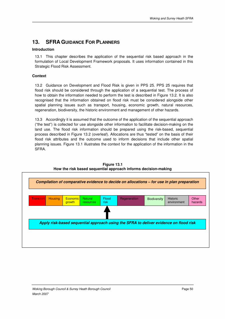
Woking and Surrey Heath SFRA
Woking Borough Council & Surrey Heath Borough Council Page 50
March 2007
13. SFRA GUIDANCE FOR PLANNERS
Introduction
13.1 This chapter describes the application of the sequential risk based approach in the
formulation of Local Development Framework proposals. It uses information contained in this
Strategic Flood Risk Assessment.
Context
13.2 Guidance on Development and Flood Risk is given in PPS 25. PPS 25 requires that
flood risk should be considered through the application of a sequential test. The process of
how to obtain the information needed to perform the test is described in Figure 13.2. It is also
recognised that the information obtained on flood risk must be considered alongside other
spatial planning issues such as transport, housing, economic growth, natural resources,
regeneration, biodiversity, the historic environment and management of other hazards.
13.3 Accordingly it is assumed that the outcome of the application of the sequential approach
(“the test”) is collected for use alongside other information to facilitate decision-making on the
land use. The flood risk information should be prepared using the risk-based, sequential
process described in Figure 13.2 (overleaf). Allocations are thus “tested” on the basis of their
flood risk attributes and the outcome used to inform decisions that include other spatial
planning issues. Figure 13.1 illustrates the context for the application of the information in the
SFRA.
Figure 13.1 How the risk based sequential approach informs decision-making
Transport Housing Economic growth
Natural resources
Regeneration Biodiversity Historic environment
Other hazards
Flood risk
Compilation of comparative evidence to decide on allocations – for use in plan preparation
Apply risk-based sequential approach using the SFRA to deliver evidence on flood risk
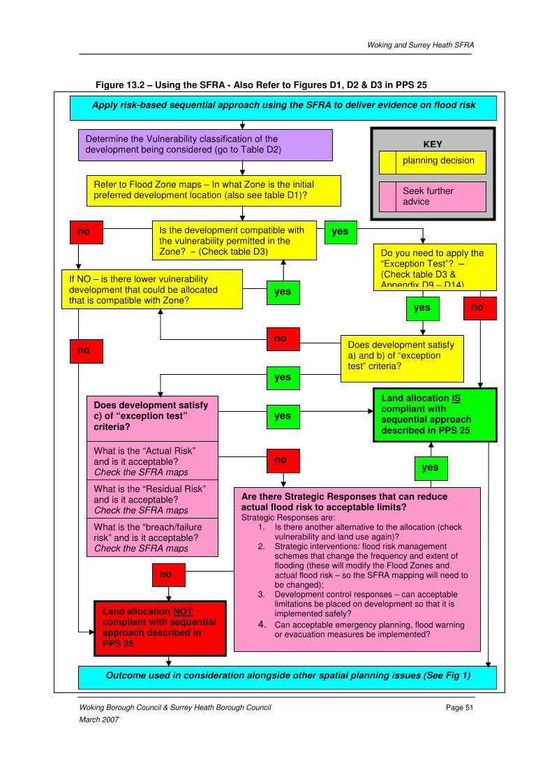
Woking and Surrey Heath SFRA
Woking Borough Council & Surrey Heath Borough Council Page 51
March 2007
Figure 13.2 – Using the SFRA - Also Refer to Figures D1, D2 & D3 in PPS 25
Determine the Vulnerability classification of the development being considered (go to Table D2)
Refer to Flood Zone maps – In what Zone is the initial preferred development location (also see table D1)?
Is the development compatible with the vulnerability permitted in the Zone? – (Check table D3)
Does development satisfy a) and b) of “exception test” criteria?
Land allocation IS compliant with sequential approach described in PPS 25
Does development satisfy c) of “exception test” criteria?
What is the “Actual Risk” and is it acceptable? Check the SFRA maps
What is the “Residual Risk” and is it acceptable? Check the SFRA maps
What is the “breach/failure risk” and is it acceptable? Check the SFRA maps
Are there Strategic Responses that can reduce actual flood risk to acceptable limits? Strategic Responses are:
1. Is there another alternative to the allocation (check vulnerability and land use again)?
2. Strategic interventions: flood risk management schemes that change the frequency and extent of flooding (these will modify the Flood Zones and actual flood risk – so the SFRA mapping will need to be changed);
3. Development control responses – can acceptable limitations be placed on development so that it is implemented safely?
4. Can acceptable emergency planning, flood warning or evacuation measures be implemented?
yes
no
yes
yes
no
no
yes
no
no
Do you need to apply the “Exception Test”? – (Check table D3 & Appendix D9 – D14)
yes no
yes
If NO – is there lower vulnerability development that could be allocated that is compatible with Zone?
KEY
planning decision
Seek further advice
Outcome used in consideration alongside other spatial planning issues (See Fig 1)
Apply risk-based sequential approach using the SFRA to deliver evidence on flood risk
Land allocation NOT compliant with sequential approach described in PPS 25

Woking and Surrey Heath SFRA
Woking Borough Council & Surrey Heath Borough Council Page 52
March 2007
Table 13.3 Areas Identified for Potential Development in the Woking Core Strategy
Potential development sites contained within this table are based on the Woking Core Strategy, Development Plan Document, Preferred Option. (January 2006) and GIS layers provide by WBC. This table covers all sites identified in Appendix 1 of the project brief dated April 2006 as well as other sites identified as potentially being at risk of flooding during the course of the SFRA.
Sites Identified for Potential
Future Development Flood Zones
Actual Risk
1% annual probability fluvial event or a 0.5% annual
probability tidal event
Residual Risk
0.1% annual probability event Potential Breach Hazard Additional comments
1 Camphill Industrial Estate All zone 1 Very low Actual Risk. Inundation unlikely. Very low Residual Risk- inundation unlikely
The site is adjacent to the Basingstoke Canal and therefore potentially at risk of flooding caused by a breach of the canal or culvert failure. Information received from the Basingstoke Canal Authority has indicated that discharge from the canal to the River Ditch could result in flooding of what is referred to as Area 4 (See Appendix H). The site is adjacent to this Area.
Despite possible Residual Risks from breach site is considered suitable for industrial development provided this risk is appropriately managed.
This area is not considered at risk of fluvial flooding, however any planning application within this area in excess of 1ha will require a detailed Flood Risk Assessment.
2 Forsyth Road Industrial Estate All zone 1 Very low Actual Risk. Inundation unlikely. Very low Residual Risk- inundation unlikely
The site is located less than 350m from the Basingstoke Canal. Despite its proximity to the Basingstoke Canal, information received from the Basingstoke Canal Authority has indicated that this area is not at risk of flooding from a potential breach of the canal or culvert failure.
This site is considered suitable for vulnerable development as the site falls within Zone 1. This site is not considered at risk of fluvial flooding however any planning application for this site in excess of 1ha will require a detailed Flood Risk Assessment.
3 Goldsworth Road Industrial Estate
All zone 1 Very low Actual Risk. Inundation unlikely. Very low Residual Risk- inundation unlikely
The site is located within 350m from the Basingstoke Canal at its nearest point, and therefore potentially at risk of flooding caused by a breach of the canal or culvert failure. Information received from the Basingstoke Canal Authority has indicated that discharge from the canal to the River Ditch could result in flooding of what is referred to as Area 12 (See Appendix H). The site is in the vicinity of this Area.
Despite possible Residual Risks from breach, site is considered suitable development provided this risk is appropriately managed.
This area is not considered at risk of fluvial flooding, however any planning application within this area in excess of 1ha will require a detailed Flood Risk Assessment.
4 Robin Hood Works All zone 1 Very low Actual Risk. Inundation unlikely. Very low Residual Risk- inundation unlikely
Breach hazard analysis not undertaken in this area as topography and absence of defences suggests that there is no hazard of breach in this area.
This site is considered suitable for vulnerable development as the site falls within Zone 1. This site is not considered at risk of fluvial flooding however any planning application for this site in excess of 1ha will require a detailed Flood Risk Assessment.
5
Ash Road PFI Site
Zone 1- majority
Zone 2 – Eastern corner of eastern block
Zone 3 – Eastern boundary of eastern block
Low Actual Risk to majority of the site, although some inundation is possible from the eastern boundary.
Low Residual Risk to majority of the site, although some inundation is possible from the eastern boundary.
Breach hazard analysis not undertaken in this area as topography and absence of defences suggests that there is no hazard of breach in this area.
This site is considered suitable for vulnerable development as the majority of the site falls within Zone 1. This should be confirmed with a detailed Flood Risk Assessment, which will be required to accompany a planning application for this site.
6 Moor Lane PFI Site
Zone 1- majority
Zone 2 - South east corner of site currently Little Moor Lane Farm
Zone 3 – Eastern boundary of site
Low Actual Risk to majority of the site, although some inundation is possible from the eastern boundary.
Some Residual Risk- with inundation likely at Little Moor Lane Farm corner of site.
Breach hazard analysis not undertaken in this area as topography and absence of defences suggests that there is no hazard of breach in this area.
This site is considered suitable for vulnerable development as the majority of the site falls within Zone 1. It is noted that a Flood Risk Assessment has been completed for the site by Bettridge Turner & Partners in June 2006 (refer References), which confirmed the majority of the site falls within Flood Zone 1.
7 Brookwood Farm PFI Site All Zone 1
The minor watercourse/drain that runs past the Brookwood Farm PFI site has not been modelled and therefore Actual Risk at this site must be based on EA Flood Zones. EA Flood Zones show there to be no Actual Risk at this site.
The minor watercourse/drain that runs past the Brookwood Farm PFI site has not been modelled and therefore Residual Risk at this site must be based on EA Flood Zones. EA Flood Zones show there to be no Residual Risk at this site.
The site is located 350m from the Basingstoke Canal at its nearest point. Despite its proximity to the Basingstoke Canal, Information received from the Basingstoke Canal Authority has indicated that this area is not at risk of flooding from a potential breach of the canal or culvert failure.
This site is considered suitable for vulnerable development as the site falls within Zone 1. It is noted that a Flood Risk Assessment has been completed for the site by Bettridge Turner & Partners in June 2006 (refer to References), which confirmed the sites location within Flood Zone 1.
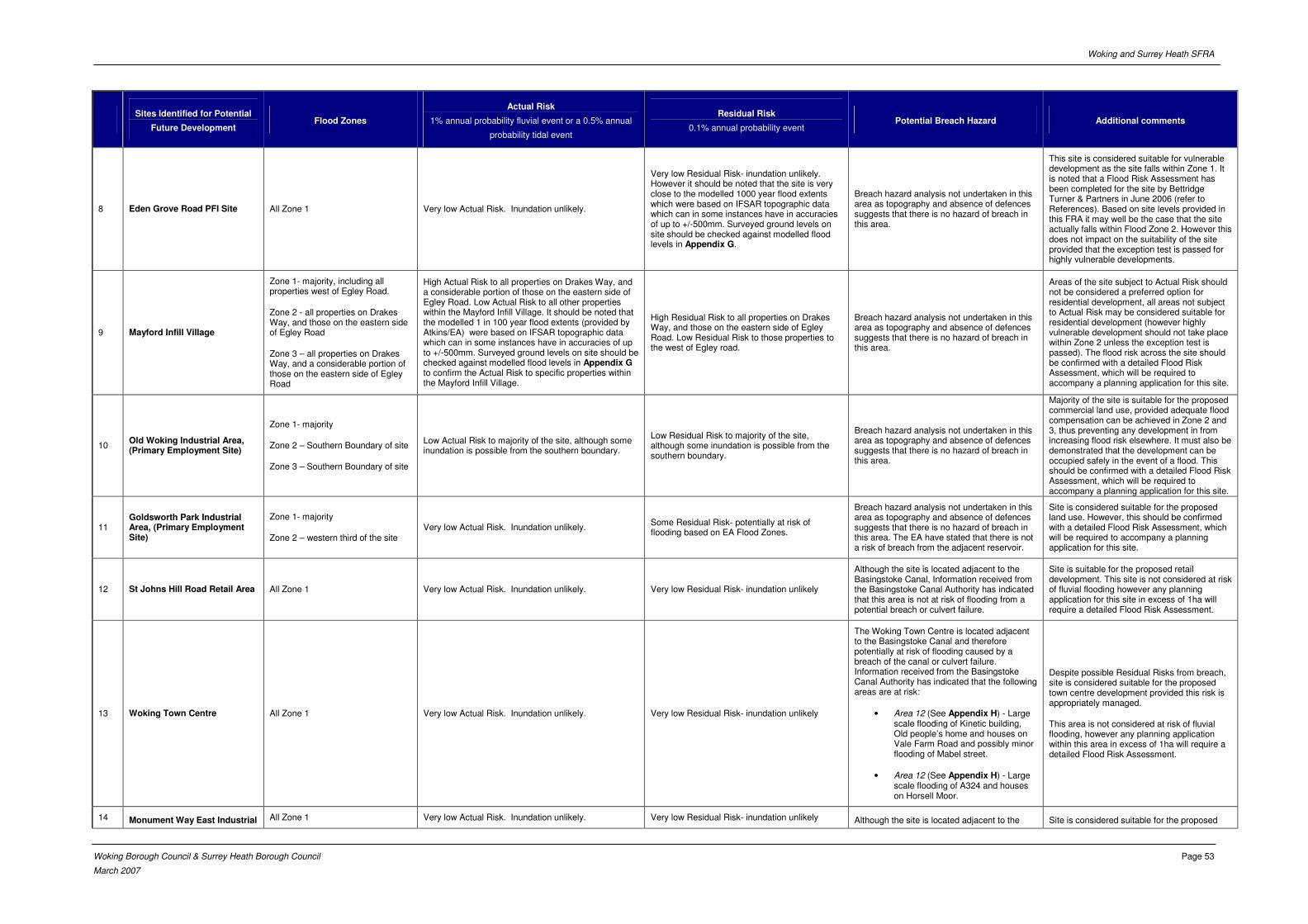
Woking and Surrey Heath SFRA
Woking Borough Council & Surrey Heath Borough Council Page 53
March 2007
Sites Identified for Potential
Future Development Flood Zones
Actual Risk
1% annual probability fluvial event or a 0.5% annual
probability tidal event
Residual Risk
0.1% annual probability event Potential Breach Hazard Additional comments
8 Eden Grove Road PFI Site All Zone 1 Very low Actual Risk. Inundation unlikely.
Very low Residual Risk- inundation unlikely. However it should be noted that the site is very close to the modelled 1000 year flood extents which were based on IFSAR topographic data which can in some instances have in accuracies of up to +/-500mm. Surveyed ground levels on site should be checked against modelled flood levels in Appendix G.
Breach hazard analysis not undertaken in this area as topography and absence of defences suggests that there is no hazard of breach in this area.
This site is considered suitable for vulnerable development as the site falls within Zone 1. It is noted that a Flood Risk Assessment has been completed for the site by Bettridge Turner & Partners in June 2006 (refer to References). Based on site levels provided in this FRA it may well be the case that the site actually falls within Flood Zone 2. However this does not impact on the suitability of the site provided that the exception test is passed for highly vulnerable developments.
9 Mayford Infill Village
Zone 1- majority, including all properties west of Egley Road.
Zone 2 - all properties on Drakes Way, and those on the eastern side of Egley Road
Zone 3 – all properties on Drakes Way, and a considerable portion of those on the eastern side of Egley Road
High Actual Risk to all properties on Drakes Way, and a considerable portion of those on the eastern side of Egley Road. Low Actual Risk to all other properties within the Mayford Infill Village. It should be noted that the modelled 1 in 100 year flood extents (provided by Atkins/EA) were based on IFSAR topographic data which can in some instances have in accuracies of up to +/-500mm. Surveyed ground levels on site should be checked against modelled flood levels in Appendix G to confirm the Actual Risk to specific properties within the Mayford Infill Village.
High Residual Risk to all properties on Drakes Way, and those on the eastern side of Egley Road. Low Residual Risk to those properties to the west of Egley road.
Breach hazard analysis not undertaken in this area as topography and absence of defences suggests that there is no hazard of breach in this area.
Areas of the site subject to Actual Risk should not be considered a preferred option for residential development, all areas not subject to Actual Risk may be considered suitable for residential development (however highly vulnerable development should not take place within Zone 2 unless the exception test is passed). The flood risk across the site should be confirmed with a detailed Flood Risk Assessment, which will be required to accompany a planning application for this site.
10 Old Woking Industrial Area, (Primary Employment Site)
Zone 1- majority
Zone 2 – Southern Boundary of site
Zone 3 – Southern Boundary of site
Low Actual Risk to majority of the site, although some inundation is possible from the southern boundary.
Low Residual Risk to majority of the site, although some inundation is possible from the southern boundary.
Breach hazard analysis not undertaken in this area as topography and absence of defences suggests that there is no hazard of breach in this area.
Majority of the site is suitable for the proposed commercial land use, provided adequate flood compensation can be achieved in Zone 2 and 3, thus preventing any development in from increasing flood risk elsewhere. It must also be demonstrated that the development can be occupied safely in the event of a flood. This should be confirmed with a detailed Flood Risk Assessment, which will be required to accompany a planning application for this site.
11 Goldsworth Park Industrial Area, (Primary Employment Site)
Zone 1- majority
Zone 2 – western third of the site Very low Actual Risk. Inundation unlikely.
Some Residual Risk- potentially at risk of flooding based on EA Flood Zones.
Breach hazard analysis not undertaken in this area as topography and absence of defences suggests that there is no hazard of breach in this area. The EA have stated that there is not a risk of breach from the adjacent reservoir.
Site is considered suitable for the proposed land use. However, this should be confirmed with a detailed Flood Risk Assessment, which will be required to accompany a planning application for this site.
12 St Johns Hill Road Retail Area All Zone 1 Very low Actual Risk. Inundation unlikely. Very low Residual Risk- inundation unlikely
Although the site is located adjacent to the Basingstoke Canal, Information received from the Basingstoke Canal Authority has indicated that this area is not at risk of flooding from a potential breach or culvert failure.
Site is suitable for the proposed retail development. This site is not considered at risk of fluvial flooding however any planning application for this site in excess of 1ha will require a detailed Flood Risk Assessment.
13 Woking Town Centre All Zone 1 Very low Actual Risk. Inundation unlikely. Very low Residual Risk- inundation unlikely
The Woking Town Centre is located adjacent to the Basingstoke Canal and therefore potentially at risk of flooding caused by a breach of the canal or culvert failure. Information received from the Basingstoke Canal Authority has indicated that the following areas are at risk:
• Area 12 (See Appendix H) - Large scale flooding of Kinetic building, Old people’s home and houses on Vale Farm Road and possibly minor flooding of Mabel street.
• Area 12 (See Appendix H) - Large scale flooding of A324 and houses on Horsell Moor.
Despite possible Residual Risks from breach, site is considered suitable for the proposed town centre development provided this risk is appropriately managed.
This area is not considered at risk of fluvial flooding, however any planning application within this area in excess of 1ha will require a detailed Flood Risk Assessment.
14 Monument Way East Industrial All Zone 1 Very low Actual Risk. Inundation unlikely. Very low Residual Risk- inundation unlikely Although the site is located adjacent to the Site is considered suitable for the proposed
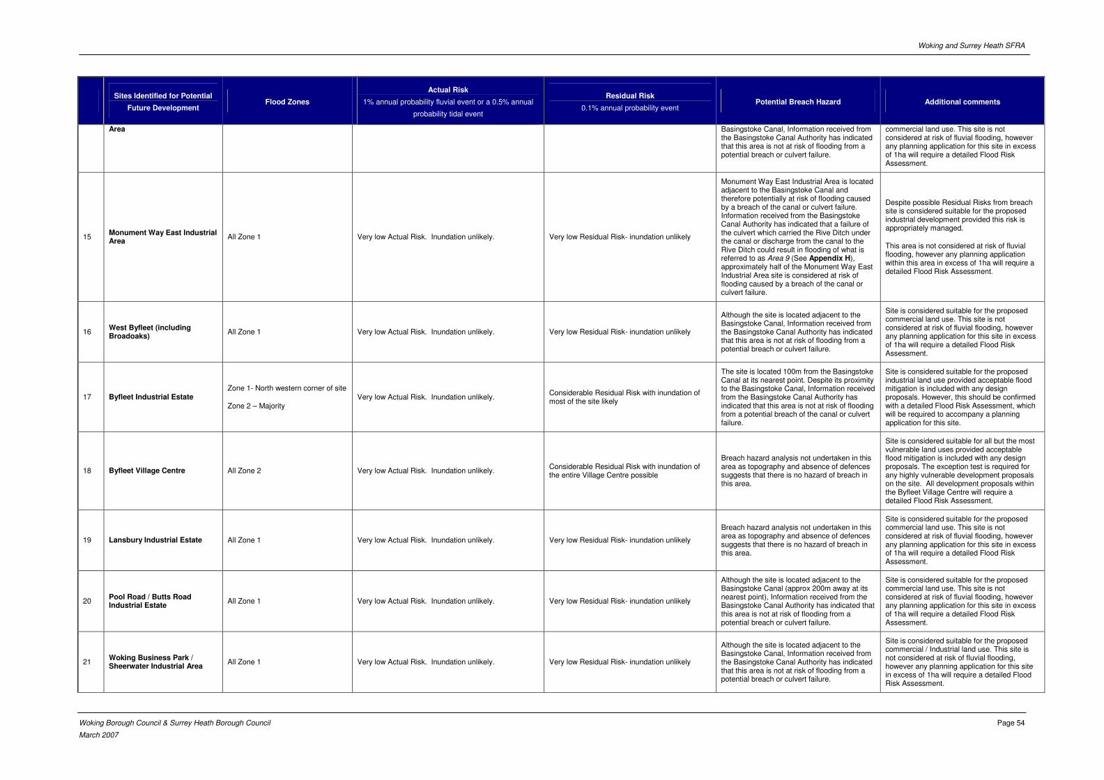
Woking and Surrey Heath SFRA
Woking Borough Council & Surrey Heath Borough Council Page 54
March 2007
Sites Identified for Potential
Future Development Flood Zones
Actual Risk
1% annual probability fluvial event or a 0.5% annual
probability tidal event
Residual Risk
0.1% annual probability event Potential Breach Hazard Additional comments
Area Basingstoke Canal, Information received from the Basingstoke Canal Authority has indicated that this area is not at risk of flooding from a potential breach or culvert failure.
commercial land use. This site is not considered at risk of fluvial flooding, however any planning application for this site in excess of 1ha will require a detailed Flood Risk Assessment.
15 Monument Way East Industrial Area
All Zone 1 Very low Actual Risk. Inundation unlikely. Very low Residual Risk- inundation unlikely
Monument Way East Industrial Area is located adjacent to the Basingstoke Canal and therefore potentially at risk of flooding caused by a breach of the canal or culvert failure. Information received from the Basingstoke Canal Authority has indicated that a failure of the culvert which carried the Rive Ditch under the canal or discharge from the canal to the Rive Ditch could result in flooding of what is referred to as Area 9 (See Appendix H), approximately half of the Monument Way East Industrial Area site is considered at risk of flooding caused by a breach of the canal or culvert failure.
Despite possible Residual Risks from breach site is considered suitable for the proposed industrial development provided this risk is appropriately managed.
This area is not considered at risk of fluvial flooding, however any planning application within this area in excess of 1ha will require a detailed Flood Risk Assessment.
16 West Byfleet (including Broadoaks)
All Zone 1 Very low Actual Risk. Inundation unlikely. Very low Residual Risk- inundation unlikely
Although the site is located adjacent to the Basingstoke Canal, Information received from the Basingstoke Canal Authority has indicated that this area is not at risk of flooding from a potential breach or culvert failure.
Site is considered suitable for the proposed commercial land use. This site is not considered at risk of fluvial flooding, however any planning application for this site in excess of 1ha will require a detailed Flood Risk Assessment.
17 Byfleet Industrial Estate Zone 1- North western corner of site
Zone 2 – Majority Very low Actual Risk. Inundation unlikely.
Considerable Residual Risk with inundation of most of the site likely
The site is located 100m from the Basingstoke Canal at its nearest point. Despite its proximity to the Basingstoke Canal, Information received from the Basingstoke Canal Authority has indicated that this area is not at risk of flooding from a potential breach of the canal or culvert failure.
Site is considered suitable for the proposed industrial land use provided acceptable flood mitigation is included with any design proposals. However, this should be confirmed with a detailed Flood Risk Assessment, which will be required to accompany a planning application for this site.
18 Byfleet Village Centre All Zone 2 Very low Actual Risk. Inundation unlikely. Considerable Residual Risk with inundation of the entire Village Centre possible
Breach hazard analysis not undertaken in this area as topography and absence of defences suggests that there is no hazard of breach in this area.
Site is considered suitable for all but the most vulnerable land uses provided acceptable flood mitigation is included with any design proposals. The exception test is required for any highly vulnerable development proposals on the site. All development proposals within the Byfleet Village Centre will require a detailed Flood Risk Assessment.
19 Lansbury Industrial Estate All Zone 1 Very low Actual Risk. Inundation unlikely. Very low Residual Risk- inundation unlikely
Breach hazard analysis not undertaken in this area as topography and absence of defences suggests that there is no hazard of breach in this area.
Site is considered suitable for the proposed commercial land use. This site is not considered at risk of fluvial flooding, however any planning application for this site in excess of 1ha will require a detailed Flood Risk Assessment.
20 Pool Road / Butts Road Industrial Estate
All Zone 1 Very low Actual Risk. Inundation unlikely. Very low Residual Risk- inundation unlikely
Although the site is located adjacent to the Basingstoke Canal (approx 200m away at its nearest point), Information received from the Basingstoke Canal Authority has indicated that this area is not at risk of flooding from a potential breach or culvert failure.
Site is considered suitable for the proposed commercial land use. This site is not considered at risk of fluvial flooding, however any planning application for this site in excess of 1ha will require a detailed Flood Risk Assessment.
21 Woking Business Park / Sheerwater Industrial Area
All Zone 1 Very low Actual Risk. Inundation unlikely. Very low Residual Risk- inundation unlikely
Although the site is located adjacent to the Basingstoke Canal, Information received from the Basingstoke Canal Authority has indicated that this area is not at risk of flooding from a potential breach or culvert failure.
Site is considered suitable for the proposed commercial / Industrial land use. This site is not considered at risk of fluvial flooding, however any planning application for this site in excess of 1ha will require a detailed Flood Risk Assessment.
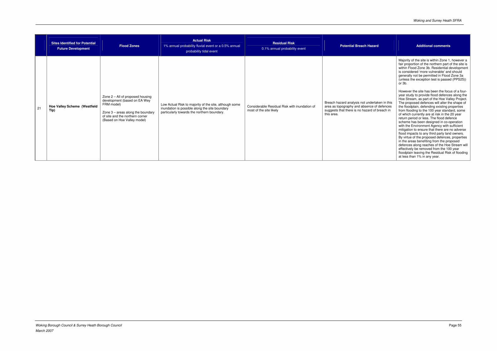
Woking and Surrey Heath SFRA
Woking Borough Council & Surrey Heath Borough Council Page 55
March 2007
Sites Identified for Potential
Future Development Flood Zones
Actual Risk
1% annual probability fluvial event or a 0.5% annual
probability tidal event
Residual Risk
0.1% annual probability event Potential Breach Hazard Additional comments
21 Hoe Valley Scheme (Westfield Tip)
Zone 2 – All of proposed housing development (based on EA Wey FRM model)
Zone 3 – areas along the boundary of site and the northern corner (Based on Hoe Valley model)
Low Actual Risk to majority of the site, although some inundation is possible along the site boundary particularly towards the northern boundary.
Considerable Residual Risk with inundation of most of the site likely
Breach hazard analysis not undertaken in this area as topography and absence of defences suggests that there is no hazard of breach in this area.
Majority of the site is within Zone 1, however a fair proportion of the northern part of the site is within Flood Zone 3b. Residential development is considered ‘more vulnerable’ and should generally not be permitted in Flood Zone 3a (unless the exception test is passed (PPS25)) or 3b.
However the site has been the focus of a four-year study to provide flood defences along the Hoe Stream, as part of the Hoe Valley Project. The proposed defences will alter the shape of the floodplain, defending existing properties from flooding to the 100 year standard, some of which currently are at risk in the 20 year return period or less. The flood defence scheme has been designed in co-operation with the Environment Agency with sufficient mitigation to ensure that there are no adverse flood impacts to any third party land owners. By virtue of the proposed defences, properties in the areas benefiting from the proposed defences along reaches of the Hoe Stream will effectively be removed from the 100 year floodplain leaving the Residual Risk of flooding at less than 1% in any year.
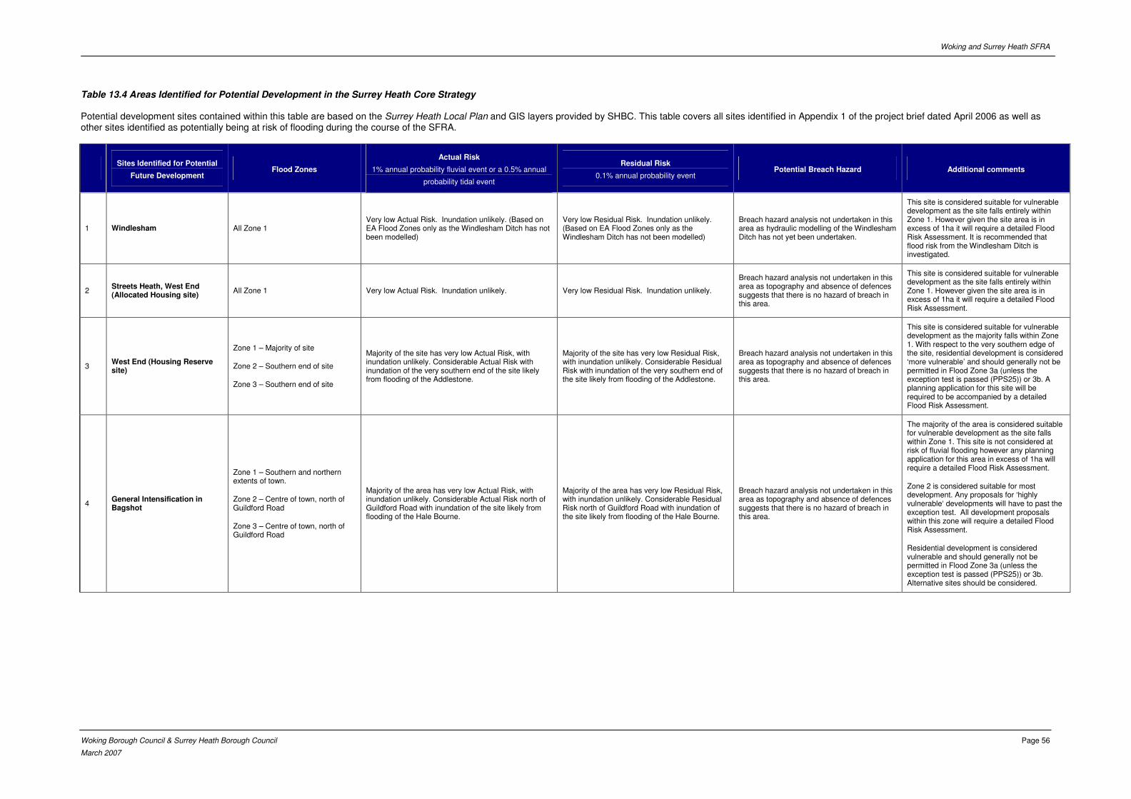
Woking and Surrey Heath SFRA
Woking Borough Council & Surrey Heath Borough Council Page 56
March 2007
Table 13.4 Areas Identified for Potential Development in the Surrey Heath Core Strategy Potential development sites contained within this table are based on the Surrey Heath Local Plan and GIS layers provided by SHBC. This table covers all sites identified in Appendix 1 of the project brief dated April 2006 as well as other sites identified as potentially being at risk of flooding during the course of the SFRA.
Sites Identified for Potential
Future Development Flood Zones
Actual Risk
1% annual probability fluvial event or a 0.5% annual
probability tidal event
Residual Risk
0.1% annual probability event Potential Breach Hazard Additional comments
1 Windlesham All Zone 1 Very low Actual Risk. Inundation unlikely. (Based on EA Flood Zones only as the Windlesham Ditch has not been modelled)
Very low Residual Risk. Inundation unlikely. (Based on EA Flood Zones only as the Windlesham Ditch has not been modelled)
Breach hazard analysis not undertaken in this area as hydraulic modelling of the Windlesham Ditch has not yet been undertaken.
This site is considered suitable for vulnerable development as the site falls entirely within Zone 1. However given the site area is in excess of 1ha it will require a detailed Flood Risk Assessment. It is recommended that flood risk from the Windlesham Ditch is investigated.
2 Streets Heath, West End (Allocated Housing site)
All Zone 1 Very low Actual Risk. Inundation unlikely. Very low Residual Risk. Inundation unlikely.
Breach hazard analysis not undertaken in this area as topography and absence of defences suggests that there is no hazard of breach in this area.
This site is considered suitable for vulnerable development as the site falls entirely within Zone 1. However given the site area is in excess of 1ha it will require a detailed Flood Risk Assessment.
3 West End (Housing Reserve site)
Zone 1 – Majority of site
Zone 2 – Southern end of site
Zone 3 – Southern end of site
Majority of the site has very low Actual Risk, with inundation unlikely. Considerable Actual Risk with inundation of the very southern end of the site likely from flooding of the Addlestone.
Majority of the site has very low Residual Risk, with inundation unlikely. Considerable Residual Risk with inundation of the very southern end of the site likely from flooding of the Addlestone.
Breach hazard analysis not undertaken in this area as topography and absence of defences suggests that there is no hazard of breach in this area.
This site is considered suitable for vulnerable development as the majority falls within Zone 1. With respect to the very southern edge of the site, residential development is considered ‘more vulnerable’ and should generally not be permitted in Flood Zone 3a (unless the exception test is passed (PPS25)) or 3b. A planning application for this site will be required to be accompanied by a detailed Flood Risk Assessment.
4 General Intensification in Bagshot
Zone 1 – Southern and northern extents of town.
Zone 2 – Centre of town, north of Guildford Road
Zone 3 – Centre of town, north of Guildford Road
Majority of the area has very low Actual Risk, with inundation unlikely. Considerable Actual Risk north of Guildford Road with inundation of the site likely from flooding of the Hale Bourne.
Majority of the area has very low Residual Risk, with inundation unlikely. Considerable Residual Risk north of Guildford Road with inundation of the site likely from flooding of the Hale Bourne.
Breach hazard analysis not undertaken in this area as topography and absence of defences suggests that there is no hazard of breach in this area.
The majority of the area is considered suitable for vulnerable development as the site falls within Zone 1. This site is not considered at risk of fluvial flooding however any planning application for this area in excess of 1ha will require a detailed Flood Risk Assessment.
Zone 2 is considered suitable for most development. Any proposals for ‘highly vulnerable‘ developments will have to past the exception test. All development proposals within this zone will require a detailed Flood Risk Assessment.
Residential development is considered vulnerable and should generally not be permitted in Flood Zone 3a (unless the exception test is passed (PPS25)) or 3b. Alternative sites should be considered.

Woking and Surrey Heath SFRA
Woking Borough Council & Surrey Heath Borough Council Page 57
March 2007
Sites Identified for Potential
Future Development Flood Zones
Actual Risk
1% annual probability fluvial event or a 0.5% annual
probability tidal event
Residual Risk
0.1% annual probability event Potential Breach Hazard Additional comments
5 General Intensification in Chobham
Zone 1 – Majority
Zone 2 – Areas to the south of Chobham.
Zone 3 - Areas to the south of Chobham.
Majority of the north of the area has very low Actual Risk, with inundation unlikely. Considerable Actual Risk south of A319 with inundation of the area likely from flooding of both the Hale and Addlestone Bourne.
Majority of the north of the area has very low Residual Risk, with inundation unlikely. Considerable Residual Risk south of A319 with inundation of the area likely from flooding of both the Hale and Addlestone Bourne.
Breach hazard analysis not undertaken in this area as topography and absence of defences suggests that there is no hazard of breach in this area.
The majority of the area is considered suitable for vulnerable development as the site falls within Zone 1. This site is not considered at risk of fluvial flooding however any planning application for this area in excess of 1ha will require a detailed Flood Risk Assessment.
Zone 2 is considered suitable for most development. Any proposals for ‘highly vulnerable‘ developments will have to past the exception test. All development proposals within this zone will require a detailed Flood Risk Assessment.
Residential development is considered vulnerable and should generally not be permitted in Flood Zone 3a (unless the exception test is passed (PPS25)) or 3b. Alternative sites should be considered.
6 General Intensification in Lightwater
Zone 1- Majority
Zone 2 – small portion of eastern side of town
Zone 3 – small portion of eastern side of town
Very low Actual Risk in the majority of the town. Inundation unlikely. Considerable Actual Risk between Guildford Road (at Riverside Avenue) and the A322, with inundation of the area likely from flooding of the Lightwater Stream.
Very Low Residual Risk in the majority of the town. Inundation unlikely. Considerable Residual Risk between Guildford Road (at Riverside Avenue) and the A322, with inundation of the area likely from flooding of the Lightwater Stream.
Breach hazard analysis not undertaken in this area as topography and absence of defences suggests that there is no hazard of breach in this area.
The majority of the area is considered suitable for vulnerable development as the site falls within Zone 1. This site is not considered at risk of fluvial flooding however any planning application for this area in excess of 1ha will require a detailed Flood Risk Assessment.
Zone 2 is considered suitable for most development. Any proposals for ‘highly vulnerable‘ developments will have to past the exception test. All development proposals within this zone will require a detailed Flood Risk Assessment.
Residential development is considered vulnerable and should generally not be permitted in Flood Zone 3a (unless the exception test is passed (PPS25)) or 3b. Alternative sites should be considered.
7 Linsford Farm, Mytchett (housing allocation site)
Zone 1 – Majority of site
Zone 2 - Western section of site Very low Actual Risk. Inundation unlikely.
Very Low Residual Risk to the majority of the site. Some Residual Risk- with inundation of western corner of site likely. (Based on EA Flood Zones only)
Breach hazard analysis not undertaken in this area as topography and absence of defences suggests that there is no hazard of breach in this area.
The majority of this site is considered suitable for development as it falls within Zone 1. ‘Highly vulnerable’ development can only be located in Zone 2 if the exception test is passed. This should be confirmed with a detailed Flood Risk Assessment, which will be required to accompany a planning application for this site.
8 Linsford Farm, Mytchett (small firms allocation site)
All Zone 2 Very low Actual Risk. Inundation unlikely. Considerable residual flood risk with the site falling within Flood Zone 2. Inundation of the site likely. (Based on EA Flood Zones only)
Breach hazard analysis not undertaken in this area as topography and absence of defences suggests that there is no hazard of breach in this area.
Site is considered suitable for the proposed commercial land use provided acceptable flood mitigation is included with any design proposals. However, this should be confirmed with a detailed Flood Risk Assessment, which will be required to accompany a planning application for this site.
9 Mytchett Place Road and Salisbury Terrace
All Zone 1 Very low Actual Risk. Inundation unlikely. Very low Residual Risk. Inundation unlikely.
Although the site is located adjacent to the Basingstoke Canal. Information received from the Basingstoke Canal Authority has indicated that this area is not at risk of flooding from a potential breach or culvert failure.
This site is considered suitable for vulnerable development as the site falls within Zone 1. This site is not considered at risk of fluvial flooding however any planning application for this site in excess of 1ha will require a detailed Flood Risk Assessment.
Woking and Surrey Heath SFRA
Woking Borough Council & Surrey Heath Borough Council Page 58
March 2007
14. CONCLUSIONS
Summary of Flood Risk in the Woking and Surrey Heath SFRA Study Area
14.1 Through the use of a strategic level 1D hydraulic modelling program (iSIS), and the
understanding of flood mechanisms and processes developed for the Woking and Surrey
Heath SFRA, flood risk in the Study Area can be summarised as follows;
14.2 Much of the flooding in the Study Area is limited to rural/farmland areas and results in
limited risk to existing development.
14.3 Within the Study Area there are areas of existing development at Actual Risk of flooding
(1 in 100 year return period). The most notable areas are summarised as follows:
• Areas of Bagshot
• Areas to the east of Lightwater
• Areas of Chobham
• Areas to the west of Camberley.
14.4 The potential impacts of climate change have been assessed, and as expected, a
significant extension of the floodplain in some areas resulted from increased river flows.
However, due to the generally well defined river floodplains which exist on many of the
watercourses within the study area, the increase in flows resulting from climate change has
had only a minimal impact on flood extent in many areas. The climate change scenarios most
notably impacted on existing developed areas in Bagshot, Lightwater, and West End. The 1 in
20 year flood extent has also been mapped to aid in defining the Functional Floodplain.
14.5 Within the Study Area there are areas of existing development considered to be at risk
of flooding in a Residual Risk flood scenario (1 in 1000 year return period). The Residual Risk
scenario flooding mechanisms and extents are similar to those for Actual Risk due to the
generally well defined floodplain topography. The most notable exceptions to this, which
impact on existing developments, are summarised below:
• Areas to the west of Camberley, particularly the industrial/commercial area to the east of the A33.
• Areas to the south of Chobham;
• Areas to the north east of Guildford Road in Bagshot.
14.6 During a flood event major transport infrastructure may be non operational. An
Emergency Plan should be formulated to facilitate an appropriate response should areas
become cut off.
14.7 There are areas within the Study Area that are potentially at risk of flooding resulting
from a breach or failure along the Basingstoke Canal alignment (refer Section 9 & Appendix
H)
Woking and Surrey Heath SFRA
Woking Borough Council & Surrey Heath Borough Council Page 59
March 2007
Outcomes of the Strategic Flood Risk Assessment
14.8 The Woking and Surrey Heath SFRA predictions are based on approach using “best
science” and “best available data”.
14.9 The Woking and Surrey Heath SFRA defines the Flood Zones, the Actual Flood Risk,
and Residual Risk and gives guidance on the application of a risk-based sequential approach
for implementation of development within the Study Area.
14.10 The approach is precautionary and allows for the potential impacts of climate change.
14.11 Computational hydraulic models have been acquired and developed to assist in the
estimation of flood risk. 1D fully hydrodynamic iSIS models have been acquired and
developed to investigate the baseline flood risk in the Study Area.
14.12 It is imperative that the results of the technical analyses described in this report are
accessible to those making strategic planning decisions.
14.13 For the Woking and Surrey Heath SFRA and its outputs to remain useful and able to
withstand scrutiny it must be monitored, managed and maintained to take into account
changes in proposals or new information. This can be achieved by assembly of a
“Management Group” with appropriate terms of reference and responsibility.
Woking and Surrey Heath SFRA
Woking Borough Council & Surrey Heath Borough Council Page 60
March 2007
15. REFERENCES
National Rivers Authority (Thames Region), Chobham Flood Alleviation Scheme
Strategy Report, September 1995.
Surrey Heath Borough Council, Surrey Heath Local Plan, December 2000.
Environment Agency, Addlestone/Hale Bourne Flood Mapping Study Interim Hydrology
Report, November 2005
Woking Borough Council, Core Strategy Development Plan Document, Preferred
Option, Woking Local development Framework, January 2006.
Woking Borough Council (Bettridge Turner and Partners), Brookwood Farm, Woking,
Flood Risk Assessment, June 2006
Woking Borough Council (Bettridge Turner and Partners), Moor Lane, Woking, Flood
Risk Assessment, June 2006
Environment Agency, Addlestone/Hale Bourne Flood Mapping Study Modelling Report, July 2006.