river corridor integrated land planning … rev. 0 i contents 1.0 introduction and background 1 2.0...
TRANSCRIPT

DOE/RL-2015-59
Revision 0
RIVER CORRIDOR INTEGRATED
LAND PLANNING DOCUMENT
Prepared for the U.S. Department of Energy
Approved for Public Release; Further Dissemination Unlimited

This page intentionally left blank.

DOE/RL-2015-59
Revision 0
River Corridor Integrated Land Planning Document
Date Published
February 2016
Prepared for the U.S. Department of Energy
P.O. Box 550
Richland, Washington 99352
________________________________ _________________________ Release Approval Date
Approved for Public Release; Further Dissemination Unlimited
By Janis D. Aardal at 3:42 pm, Feb 24, 2016
DOE/RL-2015-59
Revision 0
TRADEMARK DISCLAIMER
Reference herein to any specific commercial product, process, or service by trade name,
trademark, manufacturer, or otherwise, does not necessarily constitute or imply its
endorsement, recommendation, or favoring by the United States Government or any agency
thereof or its contractors or subcontractors.
This report has been reproduced from the best available copy.
Printed in the United States of America.
DOE/RL-2015-59, Rev. 0
ES-1
EXECUTIVE SUMMARY
This document describes the current state of Hanford Site lands, including considerations and
constraints associated with future public and tribal access and use of remediated land in the
220-square miles of the Columbia River Corridor portion of the Hanford Site. The U.S.
Department of Energy (DOE), Richland Operations Office (RL) is working with the U.S. Fish
and Wildlife Service (USFWS) to provide opportunities for stakeholders, the public, community
members, the tribes and others to provide input on future Hanford land uses.
In 1999, after an extensive public process, DOE made decisions about how Hanford Site land
could be used as cleanup from the Site’s plutonium production mission is completed. Those
decisions are provided in the Final Hanford Comprehensive Land-Use Plan1 Environmental
Impact Statement [HCP EIS (DOE/EIS-0222-F)2] Record of Decision (ROD)3. With the cleanup
progress that has been made along Hanford’s River Corridor over the ensuing 15 years,
opportunities for reuse of Hanford Site land are being realized. This document begins the process
of planning for the next steps by inventorying the land-planning constraints for the River
Corridor lands and identifying more specific land-use decisions in the Hanford comprehensive
land-use plan (CLUP).
The CLUP policies, recreational facility development and other future land uses in the River
Corridor are influenced by a number of land-planning considerations that constrain the River
Corridor lands. These planning constraints include CLUP land-use designations, the Hanford
Reach National Monument (HRNM), the Manhattan Project National Historical Park, ecological
and cultural resources, DOE environmental and safety programs, real estate encumbrances,
post-cleanup institutional controls, and infrastructure.
Current constraints impede or prevent the ability to establish uncontrolled public and tribal
access to the lands along the Columbia River. Security controls and environmental permits
related to DOE’s ongoing cleanup mission will need to be modified to maintain compliance with
the associated requirements. Several actions have been defined ranging from administrative and
programmatic changes to actual physical changes. These actions include revisions to Hanford’s
Air Operating Permit4 and Radioactive Air Emissions License (FF-015), along with
administrative changes to various security programs that regulate the current controlled-access
areas.
1DOE/EIS-0222-F, 1999, Final Hanford Comprehensive Land-Use Plan Environmental Impact Statement,
U.S. Department of Energy, Washington, D.C. 2The CLUP was reaffirmed in two Supplement Analyses to the HCP–EIS (DOE/EIS–0222–SA–01; June 2008, and
DOE/EIS-0222-SA-02; April 2015) and amended ROD (73 FR 55824; September 26, 2008). 364 FR 61615, 1994, “Record of Decision: Hanford Comprehensive Land-Use Plan Environmental Impact
Statement (HCP EIS),” Federal Register, Vol. 64, No. 218, pp. 61615-61625, November 12, 1999. 400-05-06, 2013, Hanford Site Air Operating Permit, Renewal 2, Washington State Department of Ecology,
Olympia, Washington. 5FF-01, 2014, Radioactive Air Emissions License for the Department of Energy Richland Office – Hanford Site,
Issued by the State of Washington Department of Health, Olympia, Washington.

DOE/RL-2015-59, Rev. 0
ES-2
Security controls are necessary in order to release those lands from radiological controls before
allowing uncontrolled public and tribal access in areas of the River Corridor. Physical security
controls include installing fencing, gates, and signage to provide demarcation between potential
future public access areas and DOE’s remaining operational areas. Although modifications to the
River Corridor would facilitate uncontrolled public and tribal access to the River Corridor, they
do not authorize this access.
The overall goal of restoring access to Hanford Site lands, along with factors being considered, is
detailed in Figure ES-1.
Figure ES-1. Hanford Site Future Access and Use.
Restore Hanford Lands for
Access and Use
Manage and operate the Manhattan Project National Historical Park in
partnership with the National Park
Service
Protect cultural resources and restore natural
resources
Work closely with our partners to enable reuse of Hanford lands
consistent with the CLUP
Increase controlled tribal
and public access and use

DOE/RL-2015-59, Rev. 0
i
CONTENTS
1.0 INTRODUCTION AND BACKGROUND ........................................................................ 1
2.0 PURPOSE AND OBJECTIVES .......................................................................................... 4
3.0 RIVER CORRIDOR LAND PLANNING CONSTRAINTS .............................................. 5
3.1 CLUP Land-Use Designations ......................................................................................... 5 3.2 Hanford Reach National Monument ................................................................................ 7 3.3 Manhattan Project National Historical Park .................................................................... 8 3.4 Ecological Resources ....................................................................................................... 8
3.4.1 Hanford’s Biological Resources ............................................................................... 9 3.4.2 Resource Management Approach and Implementation ............................................ 9
3.4.3 General Directives and Practices ............................................................................ 10
3.4.4 Ecological Compliance Assessment ....................................................................... 11
3.5 Cultural Resources ......................................................................................................... 11
3.5.1 Hanford’s Cultural Resources ................................................................................. 12 3.5.2 Resource Management Approach and Implementation .......................................... 12
3.5.3 General Directives and Practices and Compliance Assessment ............................. 12
3.6 Cultural Protected Areas ................................................................................................ 13 3.7 Natural Resource Damage Assessment ......................................................................... 13 3.8 Nuclear Facility Safety Bases ........................................................................................ 14 3.9 Emergency Management ............................................................................................... 16
3.10 Hazardous Materials Transportation .............................................................................. 18 3.11 Security .......................................................................................................................... 18
3.12 RCRA/CERCLA Controls ............................................................................................. 20 3.13 Environmental Air Permits ............................................................................................ 24
3.14 Radiological Controls .................................................................................................... 25 3.15 Real Estate Encumbrances ............................................................................................. 26
3.16 Infrastructure .................................................................................................................. 28
3.16.1 Roadway System ..................................................................................................... 28
3.16.2 Electrical Transmission and Distribution System ................................................... 29 3.16.3 Water System .......................................................................................................... 29 3.16.4 Sanitary Sewer Systems .......................................................................................... 29 3.16.5 Information Technology Network Systems ............................................................ 29
3.17 Mining ............................................................................................................................ 32
3.17.1 Active Pits ............................................................................................................... 32
3.17.2 Inactive Pits ............................................................................................................. 32
3.17.3 Proposed Pits ........................................................................................................... 32
4.0 PUBLIC AND TRIBAL ACCESS TO THE RIVER CORRIDOR .................................. 34
4.1 Nuclear Facility Safety Bases ........................................................................................ 36 4.2 Hazardous Material Transportation – Nuclear Security – RCRA - CERCLA .............. 36
DOE/RL-2015-59, Rev. 0
ii
4.3 Environmental Air Permits ............................................................................................ 36 4.4 Radiological Controls .................................................................................................... 37 4.5 Summary of Actions to Facilitate Access ...................................................................... 37
5.0 REFERENCES .................................................................................................................. 39
FIGURES
Figure 1. Land Management Areas by Agency. .......................................................................... 2
Figure 2. ILP Area of Interest. ..................................................................................................... 3
Figure 3. CLUP Land-Use Designations. .................................................................................... 6
Figure 4. Nuclear Facility Exclusive Use Zones. ...................................................................... 15
Figure 5. Hanford Site Emergency Planning Zones. ................................................................. 17
Figure 6. Current Controlled Area Boundary. ........................................................................... 19
Figure 7. River Corridor Ongoing Cleanup. .............................................................................. 21
Figure 8. Institutional Controls Areas. ....................................................................................... 23
Figure 9. Real Estate Encumbrances. ........................................................................................ 27
Figure 10. DOE Electrical Utility Lines. ..................................................................................... 30
Figure 11. Water Systems. ........................................................................................................... 31
Figure 12. Borrow Pit Areas. ....................................................................................................... 33
Figure 13. Potential Future Controlled Area Configuration. ....................................................... 35
DOE/RL-2015-59, Rev. 0
iii
TERMS
ASIL acceptable source impact level
BPA Bonneville Power Administration
BRMP Hanford Site Biological Resources Management Plan
CCP Hanford Reach National Monument Comprehensive Conservation
Plan and Environmental Impact Statement
CERCLA Comprehensive Environmental Response, Compensation, and
Liability Act of 1980
CFR Code of Federal Regulations
CGS Columbia Generating Station
CHPRC CH2M HILL Plateau Remediation Company
CLUP comprehensive land-use plan
CTUIR Confederated Tribes of the Umatilla Indian Reservation
District Cold War Era Historic District
DOE U.S. Department of Energy
Ecology Washington State Department of Ecology
EPA U.S. Environmental Protection Agency
EPZ Emergency Planning Zone
EUZ exclusive-use zone
HCP EIS Final Hanford Comprehensive Land-Use Plan Environmental
Impact Statement
HCRMP Hanford Cultural Resources Management Plan
HRNM Hanford Reach National Monument
HTSD Hanford Sitewide Transportation Safety Document
IC institutional control
ILP River Corridor Integrated Land Planning Document
IT information technology
LIGO Laser Interferometer Gravitational Wave Observatory
MEI maximally exposed individual
NDAA National Defense Authorization Act of 2015
NEPA National Environmental Policy Act of 1969
NOC notice of construction
NPS National Park Service
NRC U.S. Nuclear Regulatory Commission
NRDA natural resource damage assessment
RCRA Resource Conservation and Recovery Act of 1976
Register National Register of Historic Places
RL U.S. Department of Energy, Richland Operations Office
ROD record of decision
SPAB Site Planning Advisory Board
DOE/RL-2015-59, Rev. 0
iv
SR State Route
TAP toxic air pollutant
TED total effective dose
TEDE total effective dose equivalent
Tri-Party Agreement Hanford Federal Facility Agreement and Consent Order
USFWS U.S. Fish and Wildlife Service
WAC Washington Administrative Code
WDFW Washington Department of Fish and Wildlife
WRPS Washington River Protection Solutions LLC
WTP Waste Treatment and Immobilization Plant

DOE/RL-2015-59, Rev. 0
1
1.0 INTRODUCTION AND BACKGROUND
One of the nation’s largest and most complex environmental cleanup projects is underway at the
U.S. Department of Energy’s (DOE) Hanford Site located in southeastern Washington State.
Hanford is a 586-mi2 (366,000-acre) site that was established in 1943 as part of the Manhattan
Project, a top-secret American research and development effort to produce the first atomic bomb.
Plutonium production facilities continued operating at Hanford beyond World War II and
through the Cold War. In 1989, DOE stopped producing plutonium and began cleaning up
facilities, lands, and groundwater contaminated with hazardous materials, including
radionuclides and chemical waste.
The DOE-Office of Environmental Management manages the Hanford Site under the statutory
authority of the Atomic Energy Act of 1954 and in accordance with a host of public laws,
regulations, and DOE orders. Environmental cleanup decisions and activities are conducted
primarily under two federal laws: 1) The Comprehensive Environmental Response,
Compensation, and Liability Act of 1980 (CERCLA); and 2) the Resource Conservation and
Recovery Act of 1976 (RCRA). Cleanup efforts are regulated by the U.S. Environmental
Protection Agency (EPA) and the Washington State Department of Ecology (Ecology) under the
Hanford Federal Facility Agreement and Consent Order (Tri-Party Agreement). DOE manages
Hanford’s lands in accordance with Federal Property Management regulations under the
framework of DOE/EIS-0222-F, Final Hanford Comprehensive Land-Use Plan Environmental
Impact Statement (HCP EIS).
Significant progress is being made toward achieving the Tri-Party Agreement cleanup goals for
the operational areas surrounding the Hanford Site’s Central Plateau and more detailed planning
can begin to facilitate the future land uses established by the comprehensive land-use plan
(CLUP) to support public and tribal access6. This planning begins with understanding the
various land-planning constraints that affect the 220-square-mile area along the Columbia River,
known as the River Corridor and a recognition of where constraints currently prohibit public
access. The geographic scope of the River Corridor Integrated Land Planning Document (ILP)
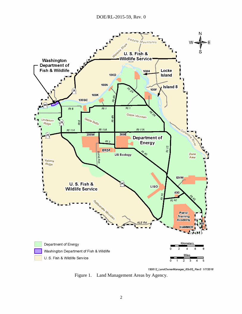
is defined first by those lands on the Hanford Site that are managed by DOE, as shown in
Figure 1. The balance of lands are managed by the U.S. Fish and Wildlife Service (USFWS) and
the Washington Department of Fish and Wildlife (WDFW) under permit by DOE. The land-use
designations in the CLUP narrow the scope further to include only those lands set aside for
preservation, conservation, and recreation. For continuity, the 4,700 acres of industrial area at
May Junction also is included in Figure 2. As such, the geographic area of interest in the scope
of the IPL covers 145,000 acres surrounding the Central Plateau and includes portions of the
Hanford Reach National Monument (HRNM) River Corridor and the McGee Ranch/Riverlands
area. The boundaries also encompass Locke Island and Island 8 in the Columbia River. The ILP
area of interest is shown in Figure 2.
6 “Public access,” as used in this document, is assumed to mean uncontrolled access for members of the public and
tribal members unless otherwise noted.
DOE/RL-2015-59, Rev. 0
2
Figure 1. Land Management Areas by Agency.

DOE/RL-2015-59, Rev. 0
3
Figure 2. ILP Area of Interest.
DOE/RL-2015-59, Rev. 0
4
2.0 PURPOSE AND OBJECTIVES
This document describes various land-planning constraints that will affect land uses and public
and tribal access for the River Corridor lands, ensuring that land-use decisions are consistent
with CLUP land-use designations and policies, and are within the constraints of the ongoing
DOE cleanup mission.
The ILP is consistent with laws, regulations, agency policies, and existing planning documents
(e.g., DOE/RL-96-32, Hanford Site Biological Resources Management Plan [BRMP], and
DOE/RL-98-10, Hanford Cultural Resources Management Plan [HCRMP]) and includes the
following objectives:
Describes various land-planning considerations for future land uses within the River Corridor
(Section 3.0).
Describes cultural resources in the River Corridor and protected areas of cultural significance
(Sections 3.5 and 3.6).
Describes the emergency preparedness considerations for notifying and evacuating the
transient population and areas where public and tribal access may be authorized
(Section 3.9).
Proposes boundaries between controlled areas associated with the ongoing cleanup mission
the Central Plateau and general access areas in the River Corridor that are designed for future
recreational activities and tribal use (Section 4.0).
This document does not address the specific land uses within the River Corridor that may be
implemented to meet the final land-use pattern defined by the CLUP. Specific land uses
consistent with the CLUP may be developed as a next step in the land management process for
these lands and documented in another document, the River Corridor Area Management Plan.
DOE/RL-2015-59, Rev. 0
5
3.0 RIVER CORRIDOR LAND PLANNING CONSTRAINTS
Under the requirements of the National Environmental Policy Act of 1969 (NEPA), the HCP EIS
was approved to establish a CLUP for the Hanford Site for at least the next 50 years. The CLUP
includes a final land-use map depicting the desired future patterns of land use on the Hanford
Site. Within the River Corridor, the land-use patterns are significantly influenced by the
conservation and preservation of ecological and cultural resources. These patterns are balanced
with land uses that include traditional tribal activities and public recreational activities along the
Columbia River.
To achieve the future land-use patterns in the River Corridor, land-use decisions will be made by
evaluating a variety of factors that constrain potential land uses. When defining the set of
constraints that apply to land-use decisions, DOE is assumed to retain ownership of the lands for
the foreseeable future. These constraints include the following:
CLUP designations
HRNM
Manhattan Project National Historical Park
Ecological resources
Cultural resources
Areas sacred to the Tribal Nations
Natural Resource Damage Assessment
Nuclear facility safety
Emergency management
Hazardous waste transportation
Security
RCRA/CERCLA security requirements and institutional controls
Environmental air permitting
Radiological controls
Realty agreements/encumbrances
Site infrastructure
Mining.
The following sections describe the existing environment supporting the land-use decision
process.
3.1 CLUP LAND-USE DESIGNATIONS
The five key land-use designations (Figure 3) in the River Corridor are: 1) Preservation;
2) Conservation (Mining); 3) Low-Intensity Recreation; 4) High-Intensity Recreation; and
5) Industrial. A majority of the River Corridor is designated for preservation or conservation to
meet the CLUP policy to “protect and preserve the natural and cultural resources of the Site for
the enjoyment, education, study, and use of future generations.” The industrial area
(May Junction) is set aside for future DOE missions or economic development. DOE has no
current plans to use this area and it remains in a conservation status.

DOE/RL-2015-59, Rev. 0
6
Figure 3. CLUP Land-Use Designations.
DOE/RL-2015-59, Rev. 0
7
Within the areas designated for conservation and preservation, the CLUP defines both
low-intensity and high-intensity recreational activities and their locations along the River
Corridor, as shown in Figure 3. Recreational activities include escorted tours of the historic B
Reactor, hiking trails, biking, boating access to the Columbia River, and visitor-serving facilities.
Implicit in these areas, as defined by CLUP policies, treaties with American Indian Tribes will
be honored as they relate to land uses and resource uses. Mining is allowed in the areas
designated for conservation; however, mining is permitted only to support government missions
or further the biological function of wetlands. All future land uses within the River Corridor
must be consistent with these land-use designations.
As prescribed by the CLUP, a Site Planning Advisory Board (SPAB), consisting of
representatives from DOE, the cooperating agencies with land-use authority, and the affected
tribes shall be formed to evaluate and make recommendations on development proposals and
land-use requests. It is anticipated that some requested activities will be permitted under the plan,
but that others will need to be modified or required to incorporate mitigation to reduce potential
impacts. To date the SPAB has not been established by DOE.
3.2 HANFORD REACH NATIONAL MONUMENT
Presidential Proclamation 7319 of 2000 established the HRNM for the purposes of conserving a
“unique and biologically diverse landscape, encompassing an array of scientific and historic
objects.” The proclamation describes the increasingly scarce objects of scientific and historic
interest of the Hanford Site, including the shrub-steppe ecosystem, the Hanford Reach of the
Columbia River, the wealth of uncommon native plant and animal species, the rich
archaeological and historic record, and other values of national significance.
In June 2000, the HRNM was established by Presidential proclamation for the preservation of
nationally significant natural, cultural, and scientific resources. The proclamation recognizes that
Native American groups have cultural ties to the monument: “Hundreds of prehistoric
archaeological sites have been recorded, including the remains of pithouses, graves, spirit quest
monuments, hunting camps, game drive complexes, quarries and hunting and kill sites” are
contained within the monument. Nothing in the proclamation shall enlarge or diminish the Treaty
of 1855 language of any Indian Tribe.
The proclamation directs the USFWS to manage the HRNM under existing agreements with
DOE, and directs DOE to manage the lands within the monument not subject to management
agreements with USFWS, and to consult with the Secretary of the Interior in developing any
management plans and rules and regulations governing portions of the monument for which
DOE has management responsibility.
DOE manages approximately 30,000 acres of the HRNM under the guidelines of Presidential
Proclamation 7319 and the CLUP. The USFWS oversees 165,000 acres of the HRNM under a
DOE permit and memorandum of understanding, guidelines of the Proclamation and the Hanford
Reach National Monument Comprehensive Conservation Plan and Environmental Impact
Statement (CCP) (USFWS 2008). The CCP, developed and approved through the NEPA
process, is consistent with DOE’s CLUP, with a focus on management goals, objectives, and
actions aimed at fulfilling the purposes of the monument under the authority of the National
Wildlife Refuge System Administration Act of 1966.
DOE/RL-2015-59, Rev. 0
8
The WDFW, under DOE permit, manages approximately 800 acres of monument land northwest
of Vernita Bridge to provide public fishing and boat launching.
3.3 MANHATTAN PROJECT NATIONAL HISTORICAL PARK
In December 2014, as part of the National Defense Authorization Act of 2015 (NDAA), Congress
passed legislation authorizing the creation of the Manhattan Project National Historical Park at
Oak Ridge, Tennessee; Los Alamos, New Mexico; and at the Hanford Site in the state
Washington. The legislation required the Secretary of Energy and Secretary of Interior to sign a
Memorandum of Agreement (MOA) within one year to outline roles and responsibilities and
determine which of the eligible historic facilities would be included in the park at each of the
three locations. A joint DOE-Headquarters (HQ)/Field team worked extensively with a National
Park Service (NPS) HQ/Regional team to negotiate an MOA, make recommendations on which
facilities should be in the park, and to propose boundaries for the park sites. The MOA was
signed by Energy Secretary Ernest Moniz and Secretary of the Interior Sally Jewell on
November 10, 2015, officially creating the new Park, which will be jointly managed by DOE and
NPS.
Consistent with the authorizing legislation, DOE’s obligations under the MOA are to preserve
and protect all historic resources, elements and landscapes associated with the Manhattan Project
National Historical Park narrative, and to expand public access to those areas. The NPS is
responsible for interpreting the Manhattan Project and providing all visitor services associated
with the Park. At the Hanford Site, the facilities included in the Manhattan Project National
Historical Park are the B Reactor National Historic Landmark, the Bruggemann Warehouse, the
1908 Hanford Irrigation District (Allard) Pump House, the White Bluffs Bank, and Hanford
High School (including a portion of the co-located Hanford Construction Camp). Several of
these facilities are immediately adjacent to and/or partially within the HRNM. Per the MOA,
DOE also is required to maintain and preserve historic elements associated with the Park
facilities and interpretive themes as if they were within the Park boundaries.
3.4 ECOLOGICAL RESOURCES
Ecological resource stewardship is an integral part of DOE’s responsibilities at the Hanford Site.
Appropriate management strategies and actions, based on the best scientific information
available, are important components of stewardship and land-use planning at the Site.
The BRMP is DOE’s primary implementation plan for managing biological resources under
the CLUP.
The BRMP establishes DOE’s management objectives, strategies, actions, and general directives
for managing biological resources on the Hanford Site. The objective of the BRMP is to provide
a consistent approach to protecting and managing biological resources onsite. Essential aspects
of Hanford Site biological resource management include resource monitoring, impact
assessment, mitigation, and restoration. The BRMP has the following overarching goals:
Foster preservation of important biological resources
Minimize adverse impacts to biological resources from Site development and other
management activities
Balance the Site cleanup mission with resource stewardship obligations.

DOE/RL-2015-59, Rev. 0
9
3.4.1 Hanford’s Biological Resources
The Hanford Site lies within the interior, low-elevation Columbia River Basin, which is within
the shrub-steppe zone. The diversity of physical features across the Hanford Site contributes to a
corresponding diversity of biological communities. The majority of the Hanford Site consists of
shrub-steppe habitats. In addition, valuable riparian, wetland, and aquatic habitats are associated
with the Hanford Reach of the Columbia River. The Hanford Site also contains rarer terrestrial
habitats such as riverine islands, bluffs and cliffs, basalt outcrops, and sand dunes. Both
shrub-steppe and riparian habitats are considered “priority habitats” by the WDFW.
Washington’s Natural Heritage Program mapped and classified portions of the native plant
communities found on the Hanford Site as priority ecosystems.
The Hanford Site is home to at least 46 species of mammals, 10 species of reptiles, 5 species of
amphibians, more than 200 species of birds, and many more than 1,000 species of insects and
invertebrates, and approximately 700 species of plants. There have been 46 fish species
identified in the Hanford Reach, as well as numerous insect, crayfish, and mollusk species.
Many of these species are considered to be rare or of special concern to federal or state resource
management agencies.
The Columbia River is designated as critical habitat for three federal endangered or threatened
fish species (Upper Columbia River spring Chinook, Upper Columbia River steelhead, and bull
trout). Two federal threatened terrestrial plant species (Umtanum buckwheat and White Bluffs
bladderpod) grow on the Hanford Site. The greater sage grouse is currently a candidate for
listing under the Endangered Species Act of 1973 and, if the bird is listed, the Hanford Site may
be an important part of efforts for its recovery. In addition to these species, the Washington
Natural Heritage Program lists approximately 25 plant species as endangered, threatened,
or sensitive. The WDFW lists 29 wildlife species as threatened, endangered, sensitive, or
candidate. Also, approximately 23 plant species and 51 wildlife species are listed on the state
monitor, review, and watch list.
The ecological resource inventory at Hanford is routinely monitored and updated to ensure the
proper protection of critical ecological resources. Efforts are ongoing to update the mapping of
Hanford’s vegetation and evaluate additional conservation measures that might be appropriate.
In FY 2016, the BRMP is expected to be updated to include this new information to support
future land-use decisions.
3.4.2 Resource Management Approach and Implementation
The principal objective of BRMP is to provide strategies and management actions necessary to
sustain Hanford Site biological resources. Specific resource management objectives for the Site
are as follows:
Protect species and habitats of state and federal concern
Maintain and preserve native biological diversity
Reduce the spread of invasive species and provide integrated control of noxious weeds
Where and when feasible, improve degraded habitats to increase landscape connectivity and
native diversity
Reduce and minimize fragmentation of habitats

DOE/RL-2015-59, Rev. 0
10
Maintain landscapes that provide regional connectivity to habitats surrounding the Site.
3.4.3 General Directives and Practices
The following general directives and practices have been developed for managing the Site’s
biological resources. They apply to all actions occurring within the portions of the Site managed
by DOE.
All actions and activities that potentially affect biological resources require an ecological
compliance review and determination of potential impacts before proceeding. This directive
applies not only to groundbreaking disturbances and excavation, but also to any treatments or
actions that alter the current natural state of the environment, habitat, or a species population,
including mowing, prescribed burning, herbicide application in native vegetation, and
creating excessive noise. The ecological review process should be a component of early
project planning.
If an ecological compliance review determines adverse impacts to biological resources, such
as habitat alterations or disturbances that could affect the reproductive success of a species of
concern, specific mitigative actions (i.e., avoidance, minimization, or compensation) will be
identified and implemented by the responsible party.
All entities on the Hanford Site will conduct activities and work in accordance with access
restrictions and administrative designations, including the following:
Areas containing rare plant communities
Mitigation and restoration areas
Collection and propagation areas for native plant materials
Lands used under permit and leased properties
Administrative control areas for species of concern, which include bald eagle buffer
zones, fall Chinook salmon spawning locations, ferruginous hawk and burrowing owl
buffer zones, and known populations and occurrences of plant species of concern.
Activities that increase habitat fragmentation and degrade existing native habitats should be
avoided. New facilities should be located within previously disturbed areas; new linear
infrastructure development should be co-located with existing roads or corridors.
No vehicles are permitted off established roads on the Hanford Site unless specifically
approved by the DOE-Richland Operations Office (RL) and the Hanford Fire Department
unless required by an emergency situation.
Actions that remove or significantly alter native vegetation will be required to include
replanting with native species in areas not needed for ongoing operations following the
practices outlined in DOE/RL-2011-116, Hanford Site Revegetation Manual.
Plant material used for habitat improvements or habitat restoration should be native to the
Hanford Site and should be locally derived native stock.
Domestic grazing is not allowed on Hanford Site lands.
Recreational hunting, fishing, or trapping is not allowed on RL-managed lands.
DOE/RL-2015-59, Rev. 0
11
3.4.4 Ecological Compliance Assessment
The Hanford Site ecological compliance assessment incorporates an evaluation of potential
impacts to biological resources before they occur and mitigation of adverse impacts if they
do occur. This process provides an essential link between DOE’s responsibility to protect
biological resources and Site missions and activities. All actions with the potential to affect
biological resources require an ecological compliance review.
An ecological compliance review ensures the proposed action will not affect rare plants or
animals or adversely affect habitats of concern. The review requires a site-specific field survey
by a qualified biologist. Records from previous surveys, maps, photos, and scientific literature
also may be used.
If the proposed action will adversely affect rare species or habitats, the ecological compliance
review will include provisions to mitigate these impacts as defined in the BRMP. All projects
and programs are expected to comply with the requirements identified in the ecological
compliance review. These requirements may include recommendations to avoid and/or
minimize adverse impacts to ecological resources by performing one or more of the following
actions:
Implementing alternatives that would result in fewer adverse impacts
Locating the project at a less ecologically sensitive site
Reducing or modifying the project footprints
Scheduling project activities to minimize disruption of key species and functions.
In cases when significant impacts cannot be reasonably avoided or minimized, the ecological
compliance review will provide recommendations for compensatory mitigation based on the
floral and faunal characteristics or the habitat that will be disturbed.
3.5 CULTURAL RESOURCES
The Hanford Site is one of the most cultural resource-rich areas in the western Columbia Plateau.
It contains numerous well-preserved archaeological sites representing prehistoric, precontact,
and historic periods and is thought of as homeland by many Native American people, as well as
settler and homesteader families. Historic period resources include sites, buildings, and
structures from the pre-Hanford Site, Manhattan Project, and Cold War eras. Sitewide
management of Hanford’s cultural resource follows the HCRMP (DOE/RL-98-10).
The HCRMP provides guidance and strategies for protecting the unique cultural resources
specific to the Hanford Site and is updated through consultation with local Tribal Nations;
interested members of the public; and local, state, and federal agencies.
The overall objective of the HCRMP is to identify, document, evaluate, protect, and preserve the
fragile, nonrenewable cultural resources found on the Hanford Site. Consistent with the CLUP,
all proposals and projects are to be integrated with existing DOE land-use-review procedures,
including cultural, historic, and archaeological resources, as outlined in the HCRMP. The DOE
procedure for cultural resources reviews applies to all federal undertakings that occur on the
Hanford Site and for any activity that has the potential to affect cultural resources.

DOE/RL-2015-59, Rev. 0
12
3.5.1 Hanford’s Cultural Resources
The Hanford Site has more than 1,260 recorded archaeological sites, 208 are eligible for listing
in 36 CFR 60, “National Register of Historic Places” (Register), and 46 are listed. Seven
Archaeological Districts and Archaeological Sites are listed in the Register and four
Archaeological Districts are eligible for listing in the Register. Several recorded and unrecorded
Traditional Cultural Properties are also located at the Hanford Site. The number of recorded
resources will increase as more land is archaeologically surveyed.
Historic properties that have been affected by Hanford’s cleanup mission may have ongoing
mitigation activities developed in project memoranda of agreement with the State Historic
Preservation Officer and the Advisory Council on Historic Preservation.
The Hanford Site Manhattan Project and Cold War Era Historic District (District) and its
associated programmatic agreement (DOE/RL-96-77) address management of 185 buildings,
structures and complexes selected as contributing properties and approximately 900 buildings
and structures identified as either contributing properties not selected for mitigation or as
noncontributing properties of the District.
3.5.2 Resource Management Approach and Implementation
The HCRMP provides requirements and management actions necessary to protect and manage
significant cultural resources and historic properties. Specific resource management objectives
are as follows:
Take into account the effects of projects on Register cultural resources and historic properties
Manage and protect Register cultural resources
Maintain and operate records and databases to ensure cultural resource locations and
previously surveyed areas are documented and searchable.
3.5.3 General Directives and Practices and Compliance Assessment
The following directives and practices have been developed for cultural resource management
for actions occurring within RL-managed portions of the Site.
All actions and activities that have the potential to affect cultural resources require a cultural
resources compliance review and determination of potential impacts before they can proceed.
This directive applies to groundbreaking disturbances and excavation, and any treatments or
actions that could affect a cultural resource or historic property including mowing, prescribed
burning, herbicide application, and off-road driving. The cultural resources compliance
review process should be a component of early project planning.
The cultural resources compliance review is project specific and analyzes the potential
effects to cultural resources for a defined project scope. The cultural resources compliance
review must be conducted by a qualified archaeologist meeting the Secretary of the Interior’s
Professional Qualification Standards for Archaeology. At a minimum, each review must
include a well-defined project scope of work and a literature review of known historic
properties, archaeological sites, traditional cultural places, historic structures, and previous
cultural resources surveys. The results of this research will determine the effect each project
may have on cultural resources and historic properties.

DOE/RL-2015-59, Rev. 0
13
When a cultural resources compliance review determines the presence of cultural resources
within the project area that cannot be avoided, a determination of Register eligibility is
completed and specific mitigations will be identified (i.e., avoidance, minimization, or
project redesign) and implemented by the responsible party.
Initiate consultation with Tribal Nations, the Washington State Historic Preservation Officer,
the Advisory Council on Historic Preservation, and interested parties in accordance with the
HCRMP.
3.6 CULTURAL PROTECTED AREAS
Since the Hanford Site was established, the Tribal Nations have stated that there are areas of
special significance located within the Hanford Site. At Hanford, the DOE works with the
Confederated Tribes and Bands of the Yakama Nation, Confederated Tribes of the Umatilla
Indian Reservation (CTUIR), the Nez Perce Tribe, and the Wanapum Band. The role of Tribal
Nations at Hanford is guided by DOE O 144.1, Department of Energy American Indian Tribal
Government Interactions and Policy, communicating departmental, programmatic, and field
responsibilities for interacting with American Indian governments. DOE O 144.1 incorporates
both the policy and the consultation guidance for working with Tribal Nations at the Hanford
Site and further defines cultural resources as including sacred sites that have importance to
American Indian peoples. Under Executive Order No. 13007, Indian Sacred Sites, as federal
managers of the Hanford Site, DOE should accommodate access and use, and avoid adversely
affecting the physical integrity of sacred areas.
Over the last several years, RL has consulted with the Confederated Tribes and Bands of the
Yakama Nation, the Confederated Tribes of the Umatilla Indian Reservation, the Nez Perce
Tribe and the Wanapum Band of Indians to identify these sacred areas. Through tribal
consultation, RL will be establishing “Cultural Protected Areas.” These areas are culturally or
religiously significant to an Indian Tribe or Band and may contain significant materials, objects
or places. RL will develop management plans for these areas in consultation with the Tribal
Nations. These plans may include information about tribal access and use, public access and use,
signage, erosion control, re-vegetation and/or restoration and monitoring.
3.7 NATURAL RESOURCE DAMAGE ASSESSMENT
Under the umbrella of CERCLA, when contaminant releases are suspected to have led to
“injury” of natural resources, federal law requires government officials, acting as natural
resource “trustees,” to conduct a natural resource damage assessment (NRDA) process.
The objective of this process is to restore, replace, or acquire the equivalent of the injured natural
resources and to compensate the public for any loss of services that occurs while natural
resources are in an injured state.
The U.S. Department of the Interior promulgated regulations that establish a framework and a set
of procedures for conducting a NRDA. These regulations define three sequential NRDA phases:
Pre-assessment
Injury assessment
Post-assessment/restoration. This phase may involve restoration in some areas of the
Hanford Site.
DOE/RL-2015-59, Rev. 0
14
During the post-assessment/restoration phase, the trustees prepare an assessment report and make
a formal claim for damages from the responsible parties. On settlement of the claim or awarding
of damages, this phase concludes by implementing a restoration plan. The objectives of this plan
are to restore affected natural resources to their baseline condition and compensate the public for
the interim loss of services resulting from those resources. Although most restoration projects
begin during the post-assessment phase, some restoration projects may occur earlier in the
NRDA process.
The Hanford Natural Resource Trustee Council may agree upon early restoration activities on
Hanford, where feasible and appropriate, to accelerate site recovery. Because projects
implemented under NRDA are designed to compensate for natural resource injuries, the scope
may create constraints on future uses of the associated lands to ensure continued protection of
the resources. It is possible that restoration projects will occur within the ILP area of interest, as
well as within the HRNM and Central Plateau.
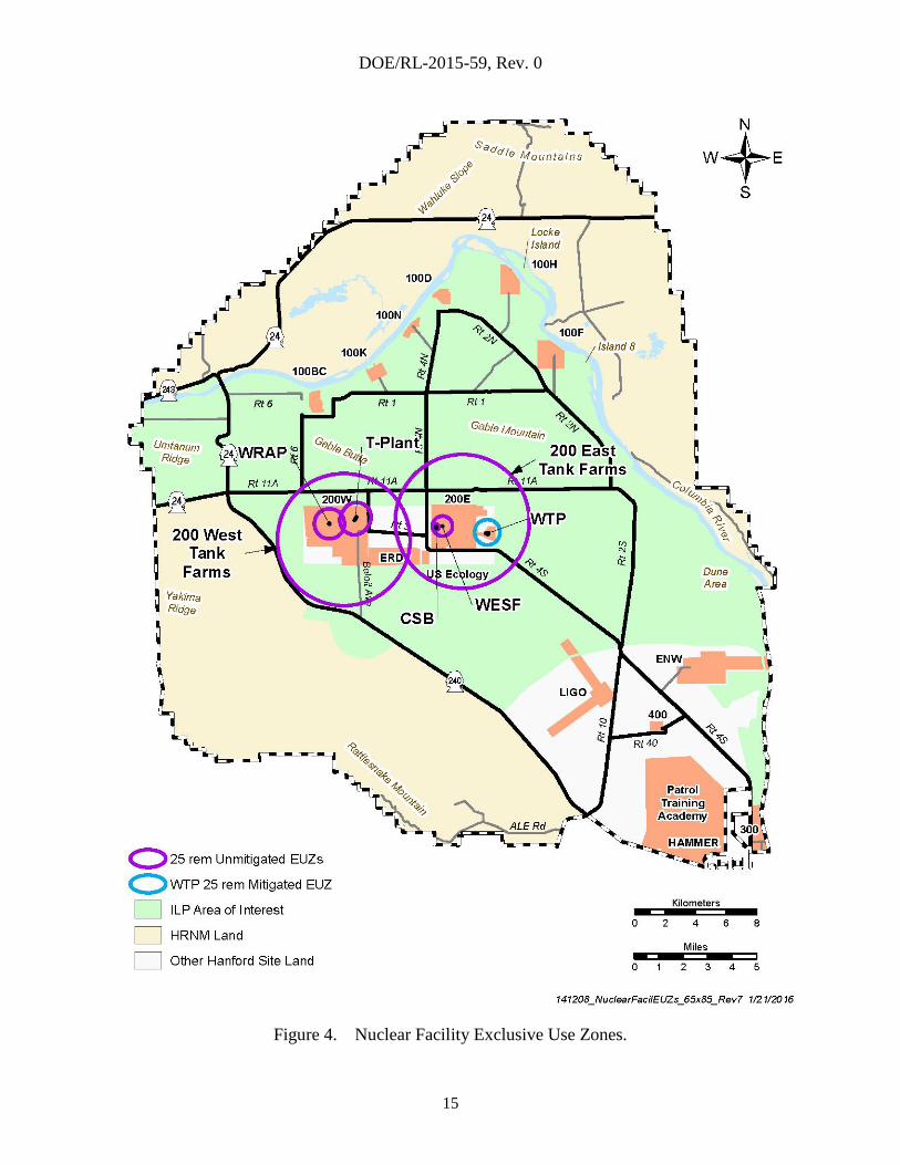
3.8 NUCLEAR FACILITY SAFETY BASES
Risks associated with handling, processing, and storing nuclear materials at the Hanford Site
dictate the need for nuclear facilities to be designed, constructed, and operated to strict standards
that ensure risks are prevented and/or mitigated such that the workers, public, and environment
are protected. The CLUP describes protective safety buffer zones around nuclear facilities to
limit public exposure to radiological and hazardous chemicals from routine operations and
accidents. These zones, known as exclusive use zones (EUZ), extend from the facility to a
distance that the public could potentially be exposed to radiological doses from routine and
accidental releases, to the point where uncontrolled public access can be routinely allowed.
For potential accidental releases from Hanford nuclear facilities, DOE/RL-2014-21, Review of
Exclusive Use Zones Nuclear Safety Bases in Relation to Potential Alternative Land
Use/Conveyances of the Hanford Site, provides an evaluation of the bases for establishing the
EUZs. The report concluded that the EUZs could be defined by the calculated radiological dose
consequences from accidental releases under two scenarios.
Scenario one: For nuclear facilities that do not have safety-class structures, systems, or
components to reduce radiological consequences from accidental releases, the distance to the
EUZ boundary would be defined by a potential unmitigated dose of 25 rem total effective
dose equivalent (TEDE).
Scenario two: For nuclear facilities where safety-class structures, systems, and components
have been defined to mitigate radiological releases, the distance to the EUZ boundary would
be defined by a potential mitigated dose of 25 rem TEDE.
Figure 4 shows the EUZ boundaries for each of the major Central Plateau nuclear facilities.
The EUZ for the 100K Sludge Treatment Project has not been included because the project will
be completed by 2020 before any land reuse near the 100K Area. Outside of these boundaries,
uncontrolled public and tribal access can be routinely allowed without affecting the facilities’
nuclear safety bases. Nuclear safety is only one of the protective features to ensure public safety
before routine uncontrolled public and tribal access. Other protective features include
environmental permits, radiological controls, and emergency preparedness. The discussion on
nuclear facility safety and EUZs does not account for these other features, which might be more
restrictive than features emplaced strictly from a nuclear safety perspective.
DOE/RL-2015-59, Rev. 0
15
Figure 4. Nuclear Facility Exclusive Use Zones.

DOE/RL-2015-59, Rev. 0
16
3.9 EMERGENCY MANAGEMENT
Emergency management considerations for public access areas are based on requirements
defined in DOE O 151.1C, Comprehensive Emergency Management System. This system
identifies planning, preparedness, and response activities that are required to protect permanent
and transient populations that may be affected by a release of hazardous materials.
These activities are conducted within an area called an Emergency Planning Zone (EPZ), which
is established for facilities with a potential to release hazardous materials to the environment.
The EPZs are determined based on potential emergencies in each facility’s emergency planning
hazards assessment and an evaluation process that is documented in DOE/RL-2012-18,
Evaluation of the Hanford Emergency Planning Zones.
The River Corridor is within current EPZs (Figure 5) for the Plutonium Finishing Plant, 100K
Area, 200 East and 300 Areas. As cleanup progresses for the Plutonium Finishing Plant and the
100K Area, these EPZs are expected to be reduced and finally eliminated. The 300 Area EPZ is
expected to remain relatively unchanged until demolition of buildings 324 and 325.
The hazards associated with the Waste Treatment and Immobilization Plant (WTP) will require a
new EPZ, the size is yet to be defined but can be assumed to be no larger than the 10-mile
maximum established for DOE facilities.
DOE maintains detailed planning and resources to provide time-urgent warning, protective
action direction (i.e., evacuation/sheltering), and controlling access within EPZs. Because of the
nature of activities that can be expected in general access areas, audible outdoor warning signals
(sirens) would be needed to notify the onsite public. Existing Columbia River emergency sirens
may provide coverage for some of the River Corridor, but do not provide coverage for all the
future general access areas. Based on current guidance, evacuation should be accomplished
within approximately 1 hour of an emergency, on-duty personnel would be needed to establish
access control and sweep areas to ensure evacuation has been completed. Accountability
methods, such as a visitor sign-in process, would allow emergency responders to prioritize
actions.
DOE is responsible to advise the public about how they will be notified and what actions they
should take in an emergency. Signage will be installed at the entrance, in parking lots, sign-in
locations, and other prominent points in the public access areas advising the public about what to
do in an emergency.
The onsite public who may have been exposed to hazardous materials during a declared
emergency would be monitored or provided access to medical evaluation. Current Hanford
emergency procedures would likely require more detailed planning for the monitoring and
evaluation process (e.g., locations, numbers of people, and frequency of visits).
The Columbia Generating Station (CGS) has a 10-mile EPZ that encompasses portions of the
River Corridor lands south of F Reactor. In the event of an emergency at CGS, DOE has been
responsible to determine protective actions and warn persons on the Hanford Site outside the
CGS leased lands. These responsibilities would carry forward for the onsite public who may be
within the CGS 10-mile EPZ.

DOE/RL-2015-59, Rev. 0
17
Figure 5. Hanford Site Emergency Planning Zones.
DOE/RL-2015-59, Rev. 0
18
3.10 HAZARDOUS MATERIALS TRANSPORTATION
Long-term cleanup activities associated with the Central Plateau will include transporting
hazardous materials on Site roadways. DOE O 460.1C, Packaging and Transportation Safety;
and 10 CFR 830, “Nuclear Safety Management,” require establishing and maintaining an onsite
transportation and packaging program for the safe movement of hazardous materials, substances,
and wastes. The transportation and packaging program is documented in DOE/RL-2001-36,
Hanford Sitewide Transportation Safety Document (HTSD). The program provides a level of
onsite (out-of-commerce) safety equivalent to that achieved offsite (in commerce) under
U.S. Department of Transportation regulations provided in 49 CFR 1, Subchapter C, “Hazardous
Materials Regulations,” and U.S. Nuclear Regulatory Commission (NRC) standards provided in
10 CFR 71, “Packaging and Transportation of Radioactive Material.”
The HTSD describes the transportation and packaging program for all packaging and shipments
of hazardous materials on Site-controlled access roads. The HTSD defines the Site-controlled
access roads as:
Hanford Site roads where public access is controlled or otherwise restricted. Controls
include barricades, fences, signs, and Hanford Patrol checkpoints. Road closures can
be executed on certain roads to convert a public access roadway to a controlled access
roadway.
These roads are sometimes referred to as out of commerce because the public cannot comingle
with the hazardous material shipments. When physically controlling out-of-commerce areas, the
HTSD, Section 3.2, Public Access, cites:
The Hanford Site boundary is marked by fences and signs. With the exception of one
area, public access to other than roadways is restricted. Fences, signs, and security
patrols are used to enforce the access restrictions.
If public access areas are opened in the River Corridor, converting portions of Hanford’s road
system to public access roads would require modifying barricades, fencing, and signage to mark
the out-of-commerce areas and maintain compliance with the HTSD.
3.11 SECURITY
A majority of the ILP area of interest remains controlled as a ‘property protection area’ to
support ongoing DOE missions. While more stringent security requirements exist around several
of DOE’s facilities on the Central Plateau, the property protection area is established to protect
employees, government buildings and facilities, and property. The physical restrictions of the
property protection area also comply with public safety requirements for waste management
activities under RCRA and CERCLA while providing buffer zones for nuclear safety and
security associated with facilities and activities on the Central Plateau and in the River Corridor.
Figure 6 shows the current controlled area (or property protection area) for Central Hanford.
As shown in the figure, vehicle access to the 100, 200, and North 600 Areas is through one of
three gates: 1) Wye, 2) Yakima, or 3) Rattlesnake Barricade. All three barricades are expected
to remain open and active to support DOE’s missions on the Central Plateau.

DOE/RL-2015-59, Rev. 0
19
Figure 6. Current Controlled Area Boundary.
DOE/RL-2015-59, Rev. 0
20
As with the HTSD, to maintain compliance with DOE security directives (DOE O 473.3,
Protection Program Operations), modifications to existing barricades, fencing, and signage
would be required to reduce the size of the property protection area and create general access
areas that facilitate public access and development of recreational facilities along the
River Corridor. The physical security requirements for general access areas will be a constraint
on future land uses in those areas.
3.12 RCRA/CERCLA CONTROLS
The Hanford cleanup mission follows both RCRA and CERCLA regulations. Under
Washington state regulations, the Site is considered a single RCRA facility consisting of multiple
treatment, storage, and disposal units, and is covered under one RCRA permit. The Hanford Site
also contains multiple CERCLA operable units governed by 40 CFR 300, “Protection of the
Environment.” Cleanup for each operable unit is defined under CERCLA by remedial actions
that are approved in separate RODs.
Washington state regulations for RCRA facilities and 40 CFR 300 requirements for CERCLA
operable units dictate the need to maintain physical security around active cleanup areas.
40 CFR 300.415, “Removal Actions,” part e(1), states, in part, that “fences, warning signs, or
other security or site control precautions — where humans or animals have access to the release”
are appropriate as a general rule for removal actions under CERCLA. Washington
Administrative Code (WAC) 173-303-310, “Security,” requires RCRA treatment, storage, and
disposal units to have “signs posted at each entrance to the active portion, and at other locations,
in sufficient numbers to be seen from any approach to the active portion.” The facility also must
have “an artificial or natural barrier, or a combination of both, which completely surrounds the
active portion of the facility, with a means to control access through gates or other entrances to
the active portion of the facility at all times.” These security requirements are provided in
WA7890008976 Hanford Facility Resource Conservation and Recovery Act Permit, Dangerous
Waste Portion, Rev. 8C, dated December 31, 2014.
A majority of the remedial actions have been completed for CERCLA operable units in the River
Corridor in accordance with the associated RODs. Over the long term, DOE is required to
maintain the institutional controls (ICs) specified by the CERCLA RODs, conduct CERCLA
5-Year Reviews to assess the effectiveness of the remedial actions, and determine and implement
the actions necessary for final disposition of the plutonium production reactors. DOE has no
near-term plans to delist the 300 and/or 100 Areas of the River Corridor from the CERCLA
National Priority List.
The majority of the River Corridor has been cleaned up in accordance with interim CERCLA
RODs established in the mid-1990’s. Remedial actions taken under the interim CERCLA RODs
allow for “unrestricted” surface use of the lands. DOE is in the process of obtaining final
CERCLA RODs and will complete any additional River Corridor cleanup required by the final
RODs. DOE also is remediating the 618-10 and 618-11 burial grounds, remediating a waste site
under a former chemical laboratory (324 Building) and demolishing the 324 Building itself.
DOE also is remediating the remaining waste sites and demolishing the remaining facilities in
the 100K Area, placing the last two production reactors into “interim safe storage,” and
continuing to remediate areas of contaminated groundwater called plumes, in the River Corridor
(Figure 7).

DOE/RL-2015-59, Rev. 0
21
Figure 7. River Corridor Ongoing Cleanup.
Ongoing cleanup in the 100K Area, including interim safe storage, or “cocooning” of the 100K
East and 100K West reactor buildings, will continue through approximately 2025. Remedial
actions remain for the other six cocooned reactor buildings in the 100 Areas and for groundwater
operable units. The reactor buildings will remain in their approved “interim safe storage”
configuration for up to 75 years to allow sufficient time for radiation levels within the graphite
cores to decay to levels safe for final demolition.
Active groundwater treatment systems in the 100D and 100H Areas (100-HR-3 groundwater
operable unit) and the 100K Area (100-KR-4 Groundwater Operable Unit) are expected to
operate for another 15 years or more to reduce contamination levels to acceptable standards.
Security controls under the CERCLA regulations will be evaluated for these remaining remedial
actions to support future public and tribal access.
RCRA and CERCLA waste sites on and around the Central Plateau are expected to remain under
active cleanup for 35 years or more. Additional fences (artificial barriers) and signage needs to
be placed around these remaining active areas as a demarcation between any future public access
areas in the River Corridor and DOE’s controlled waste management areas. These boundaries
LIGO
Central Plateau
100 BC
100 N
100 D & DR
100 H
100 F
Outer Area
200 EastArea
200 WestArea
400 Area
618-11
Burial Ground
618-10
Burial Ground
300 Area
Energy NW
FFTF
Inner Area
100 KE & KW
Complete
Complete
Complete
Hanford Reach
National Monument
Richland Operations Office River Corridor Projects
To Go Work
River Corridor Cleanup
Central Plateau Outer Area Cleanup Production Reactors & FFTF
Energy Northwest Hanford Reach National Monument
100 K-Area• Transport sludge to Central
Plateau for treatment
• Demolish facilities
• Remediate waste sites
• Put reactors in Interim Safe Storage
Continue groundwater treatment• Hexavalent chromium
pump and treat (D, H and K Areas)
• Strontium apatite barrier (N Area)
• Uranium sequestration (300 Area)
618-11 Burial Ground
618-10 Burial Ground
324 Building and waste sitesNote: Reactor removal and FFTF D&D Post 2030/2040
Additional work to be identified as Records of
Decision finalized

DOE/RL-2015-59, Rev. 0
22
should be consistent with those currently used for the property protection area for Site physical
security.
In addition to limiting public access to the active cleanup areas, ICs are in place to ensure
cleanup work completed in the River Corridor continues to be protective of people and the
environment. ICs are administrative and physical mechanisms used to protect the integrity of a
cleanup or response action and/or minimize exposure to residual contamination in soil and
groundwater until contamination is at levels that allow for unlimited use and
unrestricted exposure. ICs include nonengineered restrictions on activities and access to land,
groundwater, surface water, waste sites, waste disposal areas, and other areas or media that may
contain hazardous substances to minimize the potential for human exposure. DOE is responsible
for implementing, maintaining, reporting, and enforcing ICs established in the appropriate
RODs.
Implementation, maintenance, and periodic inspection requirements for ICs are described in
DOE/RL-2001-41, Sitewide Institutional Controls Plan for Hanford CERCLA Response Actions
and RCRA Corrective Actions. Specific IC information and land-use control maps are found in
DOE/RL-2001-41 (Appendix A) and individual RODs. The ROD for the Hanford 100 Area
Superfund Site 100-FR-1, 100-FR-2, 100-FR-3 100-IU2, and 100-IU-6 Operable Units
(EPA 2014) provides land-use controls that will be maintained until cleanup levels are achieved
and concentrations of hazardous substances are at levels that allow for unlimited use and
unrestricted exposure, and EPA authorizes the removal of restrictions. ICs that support
achieving remedial action objectives include the following:
Soil:
Utilize ICs in areas where contamination below 4.6 m (15 ft) exceeds residential use
cleanup levels to ensure that future activities do not carry contamination to the surface or
otherwise result in exposure to contaminant concentrations that exceed the cleanup levels.
Prohibit irrigation over or near the 107-F Retention Basin (Waste Site 116-F-14) that
represents an unacceptable surface water protection risk.
Groundwater:
Employ and maintain an excavation permit program limiting groundwater access and use
in the 100-FR-3 Operable Unit to research purposes and employee monitoring and
treatment in areas where groundwater contamination is still higher than cleanup levels.
Prevent access or use of the groundwater for drinking water purposes until cleanup levels
are met.
Figure 8 identifies areas where ICs are applicable on the Hanford Site. Detailed and site-specific
ICs are found in DOE/RL-2001-41.

DOE/RL-2015-59, Rev. 0
23
Figure 8. Institutional Controls Areas.
DOE/RL-2015-59, Rev. 0
24
3.13 ENVIRONMENTAL AIR PERMITS
WAC 173-401, “Operating Permit Regulation,” establishes the elements of a comprehensive air
operating permit program consistent with the requirements of the Clean Air Act of 1977, Title V;
WAC 173-480, “Ambient Air Quality Standards for Emission Limits for Radionuclides”; and
WAC 246-247, “Radiation Protection—Air Emissions,” establishes the specific state permitting
and compliance requirements for radioactive air emission units, while similar state requirements
for toxic air emission units, frequently referred to as “nonradioactive air emission units,” are
found in WAC 173-400, “General Regulations for Air Pollution Sources,” and WAC 173-460,
“Controls for New Sources of Toxic Air Pollutants.”
Applicable air permitting and compliance requirements for the Hanford Site are included in the
Hanford Site Air Operating Permit, No. 00-05-006, issued under the authority of the State of
Washington Departments of Ecology and Health, and the Benton Clean Air Agency. All
Hanford Site air emission units are captured in this permit and can be referenced by permit
number.
To determine compliance for radioactive emissions from air emission units, calculations are
performed for the maximally exposed individual (MEI). WAC 246-247-030 defines the MEI as
“any member of the public (real or hypothetical) who abides or resides in an unrestricted area,
and may receive the highest TEDE from the emission unit(s) under consideration, taking into
account all exposure pathways affected by the radioactive air emissions.” Developing
uncontrolled public access areas along the River Corridor require an evaluation of the MEI
location and a potential revision to Hanford’s Radioactive Air Emissions License, FF-01.
When determining compliance for nonradioactive emissions of toxic air pollutants (TAP), an
emission unit can be evaluated to show that emissions are either below the small-quantity
emissions rate or the acceptable source impact level (ASIL) for a particular TAP. Current
Hanford Site nonradioactive air emission units were reviewed and several have TAP emissions
either below a defined de minimis value where a notice of construction (NOC) application is not
required or below the small-quantity emissions rate where dispersion modeling is not required to
show compliance to the ASIL. These emission units would be unaffected by allowing public
access to the River Corridor lands. However, for several emission units on the Central Plateau,
air dispersion modeling was used to show compliance with the associated ASIL for a NOC
application submittal. The dispersion calculations used for these NOCs typically assumed a
point of exposure to the TAP at the Hanford Site boundary, outside of which routine public
access is allowed and/or expected. The point of exposure would have to be recalculated to verify
continued compliance with TAP air quality standards before establishing public and tribal access
to the River Corridor.
The Hanford Site Dangerous Waste Permit provides requirements for a risk assessment regarding
the Hanford Tank WTP operations. The WTP will include two waste vitrification facilities and a
pretreatment facility in the 200E Area of the Central Plateau. The risk assessment evaluates
potential risks to human health and ecological resources from air emissions of the WTP under
various, realistic exposure scenarios and is reported in 24590-WTP-RPT-ENV-14-002,
Environmental Risk Assessment Work Plan for the Hanford Tank Waste Treatment and
Immobilization Plant. The potential exposure scenario for recreational activities within the River
Corridor should be evaluated to determine if the scenario creates new, bounding exposure
conditions. While preliminary analyses indicate that the recreational scenario does not pose any
DOE/RL-2015-59, Rev. 0
25
higher risks than the scenarios evaluated in the current risk assessment, the assessment
documentation would need to be updated to reflect the official evaluation.
3.14 RADIOLOGICAL CONTROLS
River Corridor lands are currently monitored under the requirements of 10 CFR 835,
“Occupational Radiation Protection,” to ensure the safety of workers and visitors from the
hazards of ionizing radiation. Before establishing public and tribal access to the River Corridor,
the lands need to be evaluated and released from radiological controls.
To remove those controls and allow safe public access, DOE O 458.1, Radiation Protection of
the Public and the Environment, dictates the high-level process for the radiological clearance of
real property. Real property includes land and structures permanently attached to the land.
The radiological clearance process includes the following requirements:
Historical Site Assessment. The historical site assessment provides the radiological history of
the site being considered for clearance. The historical site assessment develops a conceptual
model describing the type (radionuclides of concern) and distribution of the radioactive material
on the site and includes recommendations about how to divide the site into survey units. It is the
basis on which authorized limits are developed and one of the bases of the main survey plan.
Authorized Limits. Authorized limits are soil concentration levels of radionuclides
(radionuclides of concern) for land and surface contamination limits for existing structures that
still meet the DOE dose constraint (25 mrem/year for humans) given the type of activity
(e.g., recreation) to be conducted on the site. Limits for biota also must be met. DOE approves
authorized limits.
Main Survey Plan. The main survey plan (sometimes called a sampling and analysis plan)
describes how radiological surveys will be conducted to demonstrate that approved authorized
limits have been met. The plan describes the number and locations of soil samples, the areas to
be radiologically scanned for elevated radioactivity, quality assurance measures, staff training
and qualifications, and operating instructions. The main survey plan is typically reviewed by an
independent verification contractor and is approved by DOE.
Field Measurements and Analyses. Field measurements and analyses include soil sampling
and surface scanning, followed by analyses to determine whether the authorized limits have been
met. These activities are sometimes supported by subplans that provide more detail on soil
sampling and surface scanning. Soil sampling analyses compare the sample results with the
authorized limit, duplicate quality assurance samples, and sometimes with the independent
verifier’s samples. DOE’s independent verification contractor may take independent soil
samples for analyses at their laboratory, examine calibrations of instruments, and perform related
activities.
Final Report. The final report summarizes results of the radiological clearance process and the
results of the measurements and analyses. The report recommends whether or not the authorized
limits have been met and justifies the recommendation. From this report, DOE will make the
final decision regarding release of the real property.

DOE/RL-2015-59, Rev. 0
26
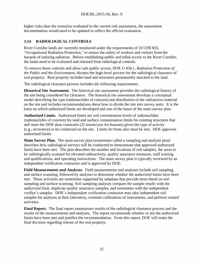
3.15 REAL ESTATE ENCUMBRANCES
RL has many agreements with non-DOE entities to use Hanford Site property. These
agreements include leases, easements, licenses, and permits. The type of agreement depends on
the type of access needed, the party the agreement is with and the length of time access is
needed. Depending on the individual agreement and its conditions, other land uses could be
denied or limited. The limitations on these agreements vary and would need to be explored on a
case-by-case basis. Figure 9 shows the real estate encumbrances on the Hanford Site.
A major subset of the Hanford Site is the HRNM (discussed in Section 3.2). The HRNM
encompasses approximately 195,000 acres within the Hanford Site. While DOE is the land
owner, the USFWS manages approximately 165,000 acres of the monument through DOE-RL
(2001), First Amended Memorandum of Understanding Between the U.S. Department of the
Interior, Fish and Wildlife Service and the U.S. Department of Energy, Richland Operations
Office for the Operation of the Fitzner-Eberhardt Arid Lands Ecology Reserve at the Hanford
Site; Fourth Amendment to the Wahluke Slope Permit. The Proclamation that established the
HRNM requires USFWS and DOE to consult each other about management of the monument
lands.
Bonneville Power Administration (BPA) has a long-term permit for electrical transmission lines
across the Site. Several substations and a network of transmission lines are located in rights of
way permitted by RL. Power generated by federal hydroelectric stations on the Snake and
Columbia rivers, and from the CGS is routed through the substations. The BPA substations and
associated transmission lines are a key component of the federal Columbia River Transmission
System for electrical power distribution in the Pacific Northwest. The width of the permitted
area varies for each section of the transmission line and substation facility depending on the
equipment in use. Additional agreements include permits for the hundreds of miles of
high-voltage electrical transmission lines that traverse the Hanford Site.
Energy Northwest leases a 1,085-acre parcel where the CGS is located. The CGS is an
NRC-licensed nuclear power plant. Energy Northwest recently completed a license extension
with the NRC and holds a permit out to 2043. An emergency planning zone surrounding the
station and a firing range could affect activities outside the leased parcel. Energy Northwest also
has a license for eight emergency sirens located along the Columbia River outside the leased
parcel.
The Laser Interferometer Gravitational Wave Observatory (LIGO) is an advanced scientific
observatory used to measure gravity waves at extremely minute levels. LIGO is operated under
a permit with the National Science Foundation by the California Institute of Technology and the
Massachusetts Institute of Technology. Although not a DOE mission, LIGO was situated on the
Hanford Site because of the availability of space, its seismic stability, and minimal man-made
sources of vibration such as heavy traffic, mining, or wind turbines. Although, the initial permit
under which LIGO was constructed is set to expire in 2018, significant equipment upgrades were
completed at LIGO in 2015 to increase measurement sensitivity. Following these upgrades,
LIGO is expected to have a research mission until approximately 2035. The permit will be
extended to support the balance of LIGO’s research.
DOE/RL-2015-59, Rev. 0
27
Figure 9. Real Estate Encumbrances.
DOE/RL-2015-59, Rev. 0
28
The U.S. Department of the Navy has a permit for interim storage of decommissioned naval
reactor plants in the operating area of the Central Plateau (pursuant to Strategic Arms Limitation
Treaty II [SALT II 1979]). The receipt of decommissioned naval reactor cores is planned to
continue through approximately 2050. Routes 2S and 11A are used to transport the reactor cores
from the Port of Benton in north Richland to the Central Plateau and must remain accessible.
DOE deeded 640 acres of the River Corridor area to Ecology for the purpose of storing,
processing, and disposing of hazardous industrial waste. This 1-mi2 parcel is located
approximately 3 miles west of LIGO, north of State Route (SR) 240. While the state of
Washington does not have specific plans to develop the site, it remains an encumbrance to other
future land uses.
DOE provides numerous smaller licenses, permits, easements, memoranda of understanding, and
other instruments that provide interim or long-term access to Hanford Site lands. These
instruments range from easements provided to Washington for state-operated roads and
highways to easements for fiber optic cable and fixed-term licenses for small
telecommunications towers. Future land-use decisions will need to consider these easements and
miscellaneous instruments on a case-by-case basis.
3.16 INFRASTRUCTURE
Hanford Site infrastructure is driven by both internal DOE mission requirements and external
needs (e.g., Hanford Site tenants, BPA transmission system). The River Corridor major
infrastructure consists of the following systems:
Roadway system
Electrical transmission and distribution system
Water system
Sanitary sewer system
Information Technology (IT) network system.
HNF-44238, Infrastructure and Services Alignment Plan, is the Site’s infrastructure strategic
plan, which is updated annually to address the changing needs of DOE and the Site tenants and
integrates these requirements to develop a long-term strategy for construction, modernization,
and elimination of Site infrastructure. Portions of the infrastructure in the River Corridor have a
long-term mission to support DOE’s cleanup efforts and the needs of other Hanford Site tenants.
The infrastructure could support the facilities associated with the Manhattan Project National
Historical Park; however, several systems are expected to be abandoned and potentially removed
as cleanup continues to progress.
3.16.1 Roadway System
The River Corridor roadway system was constructed and is maintained by DOE and its
contractors to support DOE’s missions and to access the US Ecology, Inc., low-level waste
disposal facility and the U.S. Navy’s reactor core disposal facility. With completion of cleanup
efforts in the 100 Areas (excluding reactor demolition and disposal), resources will focus on the
road system supporting Central Plateau facilities.

DOE/RL-2015-59, Rev. 0
29
No new major roadways are anticipated and DOE-funded maintenance of paved roadways in the
100 Areas will be eliminated. While the existing roadways in the 100 Areas will no longer be
maintained by the DOE-funded cleanup program, the roads may remain as available access
routes to the River Corridor to support the recreational facilities described in the CLUP as well
as access to the Manhattan Project National Historical Park facilities.
3.16.2 Electrical Transmission and Distribution System
The electrical transmission system that traverses the River Corridor includes both 115kV and
230kV transmission lines and their associated rights of way. The distribution system, shown in
Figure 10, comprises the 100K Area substation and several 13.8kV overhead distribution lines.
The system supports DOE’s ongoing cleanup missions in the River Corridor (mainly 100K) and
the B Reactor National Historic Landmark operations, tours and maintenance. Distribution lines
also provide power to raw water pumping facilities in the 100B and 100D Areas. These facilities
have a long-term mission providing raw water to the Central Plateau. While it is anticipated that
the 100K Area substation can be eliminated following completion of cleanup work in the
100K Area, the 13.8kV distribution lines in the 100 Areas are likely to remain to support current
and future DOE cleanup needs.
3.16.3 Water System
The River Corridor contains two water supplies from the Columbia River. Pump houses in the
100B and 100D Areas draw water from the river and pump it to nearby holding reservoirs.
A second set of pumps at each reservoir exports the water to the Central Plateau for potable
water, fire suppression, process cooling water, and waste remediation. These systems and the
associated buried piping are expected to remain in place for the duration of DOE’s cleanup
mission. Figure 11 shows the water system layout.
The export water system feeds a distribution line to the 100K Area that supports ongoing cleanup
and several additional lines that supply remote fire hydrants in the River Corridor. The fire
hydrant distribution lines to the 100F, 100H, and 100N Areas are expected to be abandoned and
capped, making the lines unavailable for future land uses. The 100K Area supply line will be
capped off when remediation work in the area is completed.
3.16.4 Sanitary Sewer Systems
The only active sanitary sewer systems in the River Corridor are in the 100K Area supporting
remediation work expected to continue through approximately 2025. A sanitary sewer lagoon
serves holding tanks in the 100K Area. A majority of the septic systems built to support the
production reactors in the 100 Areas were removed because they contained hazardous materials
and/or radiological contamination. The few systems that were not contaminated were isolated
and backfilled. Because these systems were closed in accordance with state permits, the legacy
sanitary sewer systems in the River Corridor do not represent a nonconformance to future land
uses.
3.16.5 Information Technology Network Systems
IT infrastructure in the River Corridor comprises radio and pager towers in the 100 Areas, Gable
Butte and Gable Mountain, and emergency sirens along the river for emergency notification of
Site workers and the public. The IT infrastructure is expected to remain in place in the near term
to continue supporting DOE’s missions.
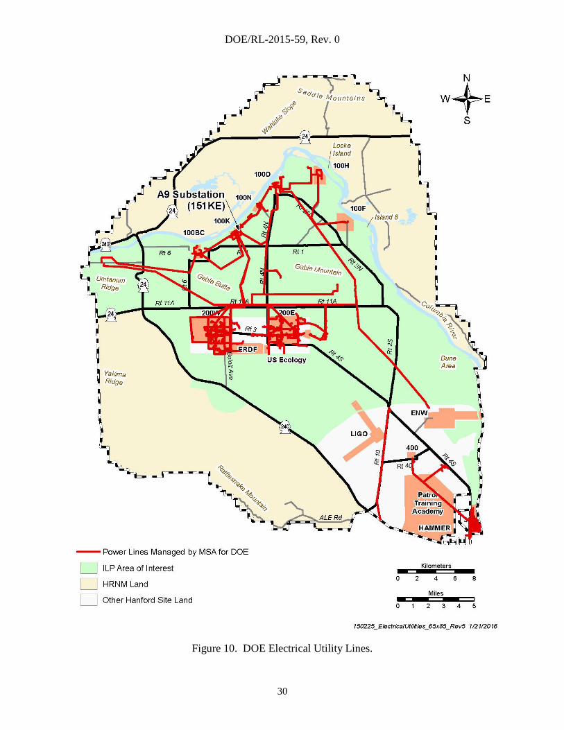
DOE/RL-2015-59, Rev. 0
30
Figure 10. DOE Electrical Utility Lines.

DOE/RL-2015-59, Rev. 0
31
Figure 11. Water Systems.
DOE/RL-2015-59, Rev. 0
32
3.17 MINING
Borrow pits have been used throughout Hanford to provide sand, gravel, and basalt materials for
the following:
Backfill and capping of waste sites
Aggregate for concrete and roads
Construction material for landfill disposal cells in the Environmental Restoration Disposal
Facility (interim cap and drainage layer)
General construction aggregate.
Figure 12 shows the borrow pits and quarries onsite. These pits are managed in accordance with
DOE/RL-2015-53, Industrial Mineral and Conservation Plan.
3.17.1 Active Pits
The ILP area of interest contains five active borrow pits (Pits H, N, 21, 23, and 24). These pits
provide aggregate and soil to support ongoing remediation activities. An environmental
assessment, DOE/EA-1934, Environmental Assessment for the Expansion of Borrow Areas on
the Hanford Site, allows for continued use of existing pits and system expansion to 11 pits
(Pits F, H, N, 6, 9, 18, 21, 23, 24, 30, and 34). Pits F and 18 are not needed and are considered
inactive. DOE/EA-1934 allows for the continued supply of aggregate and soil through FY 2023.
3.17.2 Inactive Pits
Other pits and quarries that are no longer active are scattered throughout the Site. Many of these
pits have been referred to by different names over the years (e.g., quarries, unofficial pits,
construction pits). Pits identified by the U.S. Geological Survey as borrow pits include some that
predate the Manhattan Project. The exact use for many of these pits is unknown, but most were
considered one-time use to support onsite construction of roads and rail. These pits have not
been used for many years (often 20 years) and have naturally revegetated. A significant number
of these pits are not shown on the map but can be recognized as slight depressions.
3.17.3 Proposed Pits
DOE/EIS-0222-F identifies Borrow Area C as the primary source of silt, loam, and basalt rock
borrow material available for Hanford Site remediation activities. Borrow Area C is located on
the southwest side adjacent to SR 240 opposite Rattlesnake Gate and Beloit Avenue. Borrow
Area C is not part of the HRNM, but is in the National Register of Historic Places Determination
of Eligibility Form for Laliik—eligible traditional cultural property of Rattlesnake Mountain
(Laliik) (RL 2008). Quarry 2, a small part of the northern portion of Borrow Area C, has been
used as a borrow pit.

DOE/RL-2015-59, Rev. 0
33
Figure 12. Borrow Pit Areas.
DOE/RL-2015-59, Rev. 0
34
4.0 PUBLIC AND TRIBAL ACCESS TO THE RIVER CORRIDOR
Facilitating public and tribal access to the River Corridor requires redefining the boundaries that
separate controlled areas from general access areas that are designated for future recreational
activities and tribal access. The goal is to prevent or minimize any adverse impacts to DOE’s
ongoing missions. To achieve that goal, the following criteria are applied:
The safety bases of the Central Plateau nuclear facilities will not be adversely impacted such
that the classification of safety systems would have to be amended.
Air emission units would not require additional controls or monitoring to ensure compliance
with toxic air pollutant limits.
Radioactive air emission units would not require additional controls or monitoring to ensure
compliance with the ambient air standard.
Costs for treatment, packaging, transportation, and disposal of hazardous materials do
not increase.
Significant geographic features (e.g., roadways) will be used wherever possible to simplify
the boundary demarcation.
Existing roadways will be used for general access areas.
Costs for the new boundary will be minimized by applying fencing and signage practices
used along SR 240.
Site access vehicle barricades will not be relocated.
These criteria ensure a property protection area boundary that maintains an appropriate distance
from active facilities on the Central Plateau while providing adequate public and tribal access to
areas in the River Corridor. The new boundary also facilitates access to most of the facilities
designated under the Manhattan Project National Historical Park. Figure 13 shows the
configuration of the controlled-area and where potential public and tribal access might be
authorized.
Establishing uncontrolled public access outside the new controlled area will require evaluating
and potentially modifying the following DOE programs:
Nuclear facilities safety bases
Hazardous material transportation and packaging
Environmental air permitting
Nuclear security
RCRA/CERCLA controls
Radiological controls.

DOE/RL-2015-59, Rev. 0
35
Figure 13. Potential Future Controlled Area Configuration.

DOE/RL-2015-59, Rev. 0
36
4.1 NUCLEAR FACILITY SAFETY BASES
The Central Plateau nuclear facilities define their safety bases by analyzing the potential
radiological dose consequences from off-normal facility events to a hypothetical offsite person
located at the Columbia River or Hanford’s geographic boundary. To eliminate the need to
revise the analyses and the safety bases of the nuclear facilities, the uncontrolled public that may
visit the River Corridor lands will be assumed to be “onsite.” This “onsite” designation will
drive both notification and evacuation requirements for that population in the event of an
emergency at one of the nuclear facilities.
4.2 HAZARDOUS MATERIAL TRANSPORTATION – NUCLEAR SECURITY –
RCRA - CERCLA
These program areas require physical boundaries and signage to separate controlled access areas
from uncontrolled areas. As such, new fencing, gates, and signage will be required to identify
the new controlled area boundary before establishing uncontrolled access to the River Corridor
lands. DOE/RL-2001-41 and DOE/RL-2001-36 will require minor administrative revisions to
reflect the geographic change in the controlled waste management area boundary.
4.3 ENVIRONMENTAL AIR PERMITS
Unrestricted access to the River Corridor lands for recreational activities is assumed to meet the
radioactive air emissions regulatory definition for the location of an MEI. Compliance
calculations for Hanford’s radioactive air emission units will require a revision to reflect an MEI
location west of the Columbia River instead of the current location at Ringold, east of the river.
While the results of preliminary calculations do not indicate the need to make any physical or
administrative changes to the radioactive emission units on the Central Plateau, costs will be
associated with updating the Hanford Site Air Operating Permit and Radioactive Air Emissions
License, FF-01, to reflect the new MEI location.
For nonradioactive air emission units, where regulatory compliance was demonstrated through
air dispersion modeling, public access to the River Corridor will drive the need to re-verify
compliance using a new receptor location. Those emission units and their associated
permits/approval orders are noted below:
Bechtel National Incorporated:
DE02NWP-002, “River Protection Project Waste Treatment Plant Notice of Construction
(NOC) Approval Order”
DE07NWP-004, “Criteria and Toxic Air Emissions Notice of Construction Application
Approval Order, Waste Treatment and Immobilization Plant Construction Heaters and
Dehumidifiers”
CH2M HILL Plateau Remediation Company (CHPRC):
DE00NWP-002, “Air Emission Notice of Construction Approval for Drummed and
Packaged Waste Storage, Hanford Central Waste Complex (CWC)”
DE01NWP-002, Notice of Construction for T Plant Complex”, Rev. 1

DOE/RL-2015-59, Rev. 0
37
DE03NWP-002, “Notice of Construction and Approval Order for Waste Receiving and
Processing (WRAP) Facility”
Washington River Protection Solutions LLC (WRPS):
DE05NWP-001, “Non-Radioactive Air Emissions Notice of Construction Approval
Order For Waste Retrieval Systems in Single-Shell Tank Farms,” Rev. 1
DE05NWP-002, “Criteria and Toxics Air Emissions Notice of Construction Application
for Operations of Waste Retrieval Systems in Single Shell Tank Farms and the Hanford
Single Shell Tank Categorical Retrieval Toxic Air Pollutant Emission Estimate of NOC
Approval Order,” Rev. 2
DE07NWP-003, “Effluent Treatment Facility”, Rev. 1
DE11NWP-001, “Notice of Construction Application for Operations of New Ventilation
Systems in 241-AP, SY, and AY/AZ Tank Farms and the NOC Approval Order.”
NOC 94-07, “Non-Radioactive Air Emissions Notice of Construction Permit Amendment
for the Operation of Ventilation Systems in Various Hanford Tank Farms,” Amendment
A, “241-AY and 241-AZ Ventilation Upgrades – increase in ammonia emission limit”
Pending NOC Approval Order for Core Sampler.
The Hanford Site Air Operating Permit will require revision to reflect the new receptor location
used for demonstrating compliance and to incorporate the revised compliance information under
the associated NOCs.
For WTP operations, a more formal evaluation of the recreational exposure scenario associated
with potential future recreational activities in the River Corridor, would need to be completed to
ensure that there are no unacceptable risks to the public. The evaluation would be incorporated
in 24590-WTP-RPT-ENV-14-002.
4.4 RADIOLOGICAL CONTROLS
As discussed in Section 3.14, the release of real property within the River Corridor from
radiological controls requires implementation of a clearance process under DOE O 458.1.
The radiological clearance process is necessary to allow unfettered public access to the River
Corridor lands. Because of the overall size of the potential public access areas (approximately
45,000 acres) and the history of radiological activities within those areas, the radiological release
process will be a significant undertaking and will warrant careful planning.
4.5 SUMMARY OF ACTIONS TO FACILITATE ACCESS
Reconfiguring the controlled areas of the Hanford Site to facilitate access to the River Corridor
would require both physical and administrative actions. Based on the programmatic discussions
in previous sections, these actions include the following:
Update the Hanford Site Air Operating Permit to reflect the new offsite receptor points for
the nonradioactive air emission units that use dispersion modeling for TAP compliance.
Update the Hanford Radioactive Air Emissions License (FF-01) to reflect the new MEI
locations associated with proposed public access areas in the River Corridor.

DOE/RL-2015-59, Rev. 0
38
Evaluate the need to modify the Hanford Facility RCRA Permit related to facility description
and security.
Establish perimeter fencing along the proposed controlled area boundary with “No
Trespassing” signage to meet security requirements under the Site Security Program, RCRA,
CERCLA, and the HTSD.
Install gates at appropriate intersections on the controlled boundary perimeter.
Establish procedures for authorized personnel to access the gates.
Modify the Wye Barricade interchange to provide public access around the barricade to
Route 2S and the future eastern recreational facilities in the River Corridor.
Revise 24590-WTP-ICD-MG-01-012, ICD-12-Interface Control Document for Roads, to
remove the 2S/11A route as a commuting and construction route for the WTP.
Revise DOE/RL-2001-41 to describe the new controlled-area boundary (changes to specific
ICs for waste sites in the unrestricted area may be required, but are expected to be minimal).
Revise applicable security procedures to reflect a new controlled area and general
access areas.
Perform radiological clearance of real property where public access will be authorized.
Note that these actions will facilitate public access to the River Corridor, but they do not
“authorize” access.

DOE/RL-2015-59, Rev. 0
39
5.0 REFERENCES
00-05-006, 2013, Hanford Site Air Operating Permit, Renewal 2, Washington State Department
of Ecology, Olympia, Washington.
10 CFR 71, “Packaging and Transportation of Radioactive Material,” Code of Federal
Regulations, as amended.
10 CFR 830, “Nuclear Safety Management,” Code of Federal Regulations, as amended.
10 CFR 835, “Occupational Radiation Protection,” Code of Federal Regulations, as amended.
36 CFR 60, “National Register of Historic Places,” Code of Federal Regulations, as amended.
40 CFR 300, Subpart E, “Hazardous Substance Response,” Code of Federal Regulations, as
amended.
40 CFR 300.415, “Removal Actions,” Code of Federal Regulations, as amended.
49 CFR 1, Subchapter C, “Hazardous Materials Regulations,” Code of Federal Regulations, as
amended.
24590-WTP-ICD-MG-01-012, ICD-12-Interface Control Document for Roads, current revision,
Washington River Protection Solutions, LLC, Richland, Washington.
24590-WTP-RPT-ENV-14-002, Environmental Risk Assessment Work Plan for the Hanford
Tank Waste Treatment and Immobilization Plant, Rev. 0, Bechtel National Inc., Richland,
Washington.
Atomic Energy Act of 1954, 42 USC 2011, et seq.
Clean Air Act of 1977, 42 USC 7401, et seq.
Comprehensive Environmental Response, Compensation, and Liability Act of 1980,
42 USC 9601, et seq.
DE00NWP-002, 2006, “Air Emission Notice of Construction Approval for Drummed and
Packaged Waste Storage, Hanford Central Waste Complex (CWC),” Rev. 1, Washington
State Department of Ecology, Olympia, Washington (AEI Number: J-CWC-001)
DE01NWP-002, 2013, “Notice of Construction for T Plant Complex,” Rev. 1, Washington State
Department of Ecology, Olympia, Washington.
DE02NWP-002, 2013, “River Protection Project Waste Treatment Plant Notice of Construction
(NOC) Approval Order,” Rev. 2, Washington State Department of Ecology, Olympia,
Washington (AEI number: P-WTP-001).
DE03NWP-002, 2006, Revised and Amended Air Emission Notices of Construction Approval
for Waste Receiving and Packaging (WRAP) Facility, Amendment 1, Washington State
Department of Ecology, Olympia, Washington (AEI Number: P-296W004 001).
DE05NWP-001, 2009, “Non-Radioactive Air Emissions Notice of Construction Approval
Order,” Rev. 1, Washington State Department of Ecology, Olympia, Washington
(AEI Number: P-296A046-001).
DOE/RL-2015-59, Rev. 0
40
DE05NWP-001, 2013, “Installation and Operation of a New Ventilation System in AN and AW
Tank Farms –increase in ammonia emission limit,” Washington State Department of
Ecology, Olympia, Washington.
DE05NWP-002, 2007, “Criteria and Toxics Air Emissions Notice of Construction Application
for Operations of Waste Retrieval Systems in Single Shell Tank Farms and the Hanford
Single Shell Tank Categorical Retrieval Toxic Air Pollutant Emission Estimate of NOC
Approval Order,” Rev. 2, Washington State Department of Ecology, Olympia, Washington
(AEI Number P-241A101-001).
DE07NWP-003, 2007, “Effluent Treatment Facility,” Rev. 1, Washington State Department of
Ecology, Olympia, Washington.
DE07NWP-004, 2007, “Criteria and Toxic Air Emissions Notice of Construction Application
Approval Order, Waste Treatment and Immobilization Plant Construction Heaters and
Dehumidifiers,” Washington State Department of Ecology, Olympia, Washington (AEI
number: WTP Construction Heaters & Dehumidifiers).
DE11NWP-001, 2013, “Notice of Construction Application for Operations of New Ventilation
Systems in 241-AP, SY, and AY/AZ Tank Farms and the NOC Approval Order,”
Washington State Department of Ecology, Olympia, Washington.
DOE, 2009, Department of Energy American Indian & Alaska Native Tribal Government Policy,
U.S. Department of Energy, Washington, D.C.
DOE, 2014, Memorandum of Understanding Between the Department of Energy and the
Department of the Interior, dated August 2014, U.S. Department of Energy,
Washington, D.C.
DOE O 144.1, 2009, Department of Energy American Indian Tribal Government Interactions
and Policy, U.S. Department of Energy, Washington, D.C.
DOE O 151.1C, 2005, Comprehensive Emergency Management System, U.S. Department of
Energy, Washington, D.C.
DOE O 458.1, Admin Chg 3, 2013, Radiation Protection of the Public and the Environment,
U.S. Department of Energy, Washington, D.C.
DOE O 460.1C, 2010, Packaging and Transportation Safety, U.S. Department of Energy,
Washington, D.C.
DOE O 473.3, 2011, Protection Program Operations, U.S. Department of Energy,
Washington, D.C.
DOE/EA-1934, 2013, Environmental Assessment for the Expansion of Borrow Areas on the
Hanford Site, Rev. 0, U.S. Department of Energy, Washington, D.C.
DOE/EIS-0222-F, 1999, Final Hanford Comprehensive Land-Use Plan Environmental Impact
Statement, U.S. Department of Energy, Washington, D.C.
DOE/EIS–0222–SA–01, 2008, Supplement Analysis: Hanford Comprehensive Land-Use Plan
Environmental Impact Statement, U.S. Department of Energy, Richland Operations Office,
Richland, Washington.

DOE/RL-2015-59, Rev. 0
41
DOE/EIS–0222–SA–02, 2015, Supplement Analysis of the Hanford Comprehensive Land-Use
Plan Environmental Impact Statement, U.S. Department of Energy, Richland Operations
Office, Richland, Washington.
DOE-RL, 2001, First Amended Memorandum of Understanding Between the U.S. Department of
the Interior, Fish and Wildlife Service and the U.S. Department of Energy, Richland
Operations Office for the Operation of the Fitzner-Eberhardt Arid Lands Ecology Reserve
at the Hanford Site; Fourth Amendment to the Wahluke Slope Permit, U.S. Department of
Energy, Richland Operations Office, Richland, Washington, and U.S. Department of the
Interior, Fish and Wildlife Service, Washington, D.C.
DOE/RL-96-32, 2013, Hanford Site Biological Resources Management Plan, Rev. 1,
U.S. Department of Energy, Richland Operations Office, Richland, Washington.
DOE/RL-96-77, 1996, Programmatic Agreement Among the U.S. Department of Energy,
Richland Operations Office, the Advisory Council on Historic Preservation, and the
Washington State Historic Preservation Office for the Maintenance, Deactivation,
Alteration, and Demolition of the Built Environment on the Hanford Site, Washington,
Rev. 0, U.S. Department of Energy, Richland Operations Office, Richland, Washington.
DOE/RL-98-10, 2003, Hanford Cultural Resources Management Plan, Rev. 0, U.S. Department
of Energy, Richland Operations Office, Richland, Washington.
DOE/RL-2001-36, 2011, Hanford Sitewide Transportation Safety Document, Rev. 1E,
U.S. Department of Energy, Richland Operations Office, Richland, Washington.
DOE/RL-2001-41, 2015, Sitewide Institutional Controls Plan for Hanford CERCLA Response
Actions and RCRA Corrective Actions, Rev. 8, U.S. Department of Energy, Richland
Operations Office, Richland, Washington.
DOE/RL-2011-116, 2011, Hanford Site Revegetation Manual, Rev. 0, U.S. Department of
Energy, Richland Operations Office, Richland, Washington.
DOE/RL-2012-18, 2012, Evaluation of the Hanford Emergency Planning Zones, Rev. 0,
U.S. Department of Energy, Richland Operations Office, Richland, Washington.
DOE/RL-2014-21, 2014, Review of Exclusive Use Zones Nuclear Safety Bases in Relation to
Potential Alternative Land Use/Conveyances of the Hanford Site, Rev. 2, U.S. Department
of Energy, Richland Operations Office, Richland, Washington.
DOE/RL-2015-53, Industrial Mineral and Conservation Plan, Rev. 0, U.S. Department of
Energy, Richland Operations Office, Richland, Washington.
Ecology, EPA, and DOE, 1989, Hanford Federal Facility Agreement and Consent Order,
2 vols., as amended, Washington State Department of Ecology, U.S. Environmental
Protection Agency, and U.S. Department of Energy, Olympia, Washington.
Endangered Species Act of 1973, 16 USC 35 et seq.
EPA, 2014, Hanford 100 Area Superfund Site 100-FR-1, 100-FR-2, 100-FR-3, 100-1U-2, and
100-IU-6 Operable Units, U.S. Environmental Protection Agency, Region 10,
Seattle, Washington.
DOE/RL-2015-59, Rev. 0
42
Executive Order 13007, 1996, Indian Sacred Sites, William J. Clinton, The White House,
Washington, D.C.
FF-01, 2014, Radioactive Air Emissions License for the Department of Energy Richland Office –
Hanford Site, Issued by the State of Washington Department of Health, Office of Radiation
Protection, Olympia, Washington.
HNF-44238, 2014, Infrastructure and Services Alignment Plan, Rev. 4, Mission Support
Alliance, LLC, Richland, Washington.
Howard P. “Buck” McKeon National Defense Authorization Act for Fiscal Year 2015, Public
Law 113-291.
National Environmental Policy Act of 1969, 42 USC 4321, et seq.
National Historic Preservation Act of 1966, 16 USC 470, et seq.
National Wildlife Refuge System Administration Act of 1966, 16 USC 668dd-668ee, et seq.
NOC 94-07, “Non-Radioactive Air Emissions Notice of Construction Permit Amendment for the
Operation of Ventilation Systems in Various Hanford Tank Farms, Amendment A,
“241-AY and 241-AZ Ventilation Upgrades – increase in ammonia emission limit,”
Washington State Department of Ecology, Olympia, Washington.
Presidential Proclamation 7319, 2000, Establishment of the Hanford Reach National Monument,
Public Law 100-605, as amended, William J. Clinton, The White House, Washington, D.C.
Resource Conservation and Recovery Act of 1976, 42 USC 82, et seq.
RL, 2008, National Register of Historic Places Determination of Eligibility Form for Laliik,
U.S. Department of Energy, Richland Operations Office, Richland, Washington.
SALT II, 1979, Strategic Arms Limitation Treaty II, United States of America and Union of
Soviet Socialist Republics. The text is available on line at
http://www.state.gov/www/global/arms/treaties/salt2-1.html.
USFWS, 2008, Hanford Reach National Monument Comprehensive Conservation Plan and
Environmental Impact Statement, U.S. Fish and Wildlife Service, Washington, D.C.
WA7890008976, Hanford Facility Resource Conservation and Recovery Act Permit, Dangerous
Waste Portion, Rev. 8C, dated December 31, 2014.
WAC 173-303-310, “Dangerous Waste Regulations,” “Security,” Washington Administrative
Code, as amended, Olympia, Washington.
WAC 173-400, “General Regulations for Air Pollution Sources,” Washington Administrative
Code, as amended, Olympia, Washington.
WAC 173-401, “Operating Permit Regulation,” Washington Administrative Code, as amended,
Olympia, Washington.
WAC 173-460, “Controls for New Sources of Toxic Air Pollutants,” Washington Administrative
Code, as amended, Olympia, Washington.
WAC 173-480, “Ambient Air Quality Standards and Emission Limits for Radionuclides,”
Washington Administrative Code, as amended, Olympia, Washington.

DOE/RL-2015-59, Rev. 0
43
WAC 246-247, “Radiation Protection—Air Emissions,” Washington Administrative Code, as
amended, Olympia, Washington.