road management plan - shire of mornington · pdf filethe road management plan ... the shire...
TRANSCRIPT

Road Management Plan
2011 Final Version 12 September 2011

Road Management Plan
Page 2 of 31
APPROVAL VERSION COUNCIL GOVERNMENT GAZETTE
No. MEETING
DATE No. ISSUE DATE PAGE No.
1 6 December
2004 G51 16 December
2004 3384
2 12 September
2011 G49 8 December
2011 2874
AMENDMENTS VERSION
No. DETAILS APPROVED
BY DATE
APPROVED * DATE OF
EFFECT

Road Management Plan
Page 3 of 31
Table of Contents:
1. Executive Summary.......................................................................................................4
2. About the Mornington Peninsula ....................................................................................5
3. Road Facts ....................................................................................................................7
3.1. Purpose of Asset: .................................................................................................7 3.2. Description: ..........................................................................................................7 3.3. Works: ..................................................................................................................7 3.4. Stakeholders: .......................................................................................................8 3.5. Funding: ...............................................................................................................9 3.6. Relevance of Plan to Community Plan: ................................................................9
4. Legislative Control ....................................................................................................... 11
4.1. Road Management Act: ...................................................................................... 11 4.2. Road Safety Act: ................................................................................................ 11
5. Assets to which this Plan Applies ................................................................................ 13
5.1. Classification: ..................................................................................................... 14 5.2. Register of Public Roads: ................................................................................... 19
6. Demarcation ................................................................................................................ 20
6.1. State Roads: ...................................................................................................... 20 6.2. Boundary Roads: ................................................................................................ 20 6.3. Public Transport: ................................................................................................ 20 6.4. Bridges: .............................................................................................................. 21 6.5. Street Lighting: ................................................................................................... 21 6.6. Utilities: .............................................................................................................. 21 6.7. Vehicle Crossings: .............................................................................................. 21 6.8. Paths: ................................................................................................................. 22 6.9. Equestrian Trails: ............................................................................................... 22 6.10. Roadsides: ......................................................................................................... 22
7. Levels of service .......................................................................................................... 23
7.1. Specifications and Standards: ............................................................................ 23 7.2. Inspection and Maintenance: .............................................................................. 23 7.3. Standards of Maintenance and Repair: .............................................................. 24 7.4. Reseal and Rehabilitation: .................................................................................. 25 7.5. Events Beyond Control of Council: ..................................................................... 25
8. Data Management System .......................................................................................... 26
9. Plan Improvement and Monitoring ............................................................................... 28
10. Glossary ...................................................................................................................... 29
11. Appendices ................................................................................................................. 31

Road Management Plan
Page 4 of 31
1. Executive Summary
In accordance with Division 5 of the Road Management Act 2004 the Mornington Peninsula Shire, as a road authority, has developed and published this Road Management Plan.
The Road Management Plan (referred to hereafter as the ‘Plan’) for Mornington Peninsula Shire roads and associated infrastructure assets and is a communication tool used to document current levels of service and management practices. The plan provides a transparent and a network wide approach to managing the roads.
This plan will be implemented to fulfil the Shire’s Community Plan objectives in regard to infrastructure assets and is in line with the Asset Management Policy and Strategy.
This plan will enable the Shire to fully comply with the requirements of the Road Management Act 2004, (referred to hereafter as the ‘Act’). The primary objective of the Act closely aligns with the Shire’s Asset Management Policy objective.
Section 4 of the Act states its objectives as:
“The primary object of this Act is to establish a coordinated management system that will promote safe and efficient road networks at State and local levels and the responsible use of road reserves for other legitimate purposes”. 1
The three main requirements to which the Shire needs to comply are the establishment of:
1. A Register of Roads
2. Levels of Service/Standards
3. A Management System

Road Management Plan
Page 5 of 31
2. About the Mornington Peninsula
Our Place
Mornington Peninsula Shire (MPS) is located at the fringe of Melbourne’s outer southern suburbs, between 40 and 80 kilometres south of the Melbourne CBD. Mornington Peninsula is bounded by Frankston City and the City of Casey in the north, Western Port in the east, Bass Strait in the south and Port Phillip Bay in the west.
The Shire encompasses a total land area of about 724 square kilometres, including over 190 kilometres of coastline, which is approximately 10% of Victoria’s coastline. The region is one of Melbourne’s premier holiday and retirement destinations and has magnificent landscapes, coasts and beaches that are of state significance and attract millions of visitors every year.
Our Community
The Shire has forty townships spread across the peninsula, with the majority of the residential population living along the coastline of Port Phillip Bay, between Mount Eliza and Dromana.
The Shire is a second home to many thousands of additional households from Melbourne and surrounds that make regular holiday and weekend visits seeking the health giving properties and recreational opportunities of the beautiful beaches, landscapes and natural environments. Many beach holiday houses are based along the Port Phillip coastline, with

Road Management Plan
Page 6 of 31
the population swelling by up to 30% in the summer months, mostly in the southern bayside towns from Dromana to Portsea.
Australian Bureau of Statistics (ABS) Estimated Resident Population data for the Mornington Peninsula 30 June 2008 was 145,356. The population is estimated to increase to more than 160,000 by 2021.
Almost 4 million people are recorded as visiting the Mornington Peninsula each year providing increased opportunities for tourism.
Our Environment
Approximately 70% of the Shire is retained as rural land within the Green Wedge planning zone, whilst the other 30% is taken up by towns and villages. Within the Green Wedge, there are areas of highly productive farm land as well as highly significant landscapes and ecosystems. The Mornington Peninsula and Western Port has become part of the world-wide network of biosphere reserves recognised by the United Nations. The region has been recognised for its: great biological diversity; many significant, rare native plants and vegetation; wetlands; sites of geomorphological significance; remnant indigenous vegetation; highly scenic landscape values; and sites of historic importance.
Our Economy
The Mornington Peninsula has a growing and diverse local economy that includes retail, manufacturing, construction and business services. The region also has a distinguished agricultural history, including dairy, viticulture (grapes) and horticulture (fruit, vegetables and flowers), with the existing food and wine producers being recognised as world class and industry leaders in their respective fields. Tourism is another significant contributor to the local economy, with the Peninsula being a popular weekend, recreation and holiday destination.

Road Management Plan
Page 7 of 31
3. Road Facts
3.1. Purpose of Asset:
The network of roads is provided primarily for travel and transport and the road reserves are available for other appropriate uses. 1 This might include for example provision for nature strips, remnant vegetation, native animal corridors, and utilities.
3.2. Description:
The Shire’s road network has approximately 3,700 separate roadways with a total length of approximately 1,980 km. This is made up of:
· 1,330 km of local roads with a sealed surface · 370 km of local roads with a unsealed or unformed surface · 276 km of roads controlled and maintained by VicRoads
In addition to the above length of roads, the following road assets form a significant component of the road network that the Shire has responsibility for:
· Kerbs approx 1,920 km · Shoulders: approx 500 km · Roundabouts: approx. 120 No. · Medians: approx 1,230 No. · Pathways: approx 580 km · Car parks: approx 500 No. · Road bridges: 7 No. · Major culverts: approx. 30 No. · Drainage Pits: approx. 47,000 No. · Drainage Pipes: approx. 1,200 km
3.3. Works:
· The maintenance of bitumen surface pavements and shoulders requires attention by service providers to repair corrugations, potholes, depressions and scouring. Intervention levels have been specified for road failures and, when repaired, must comply with Shire standards.
· Maintenance for unsealed pavements and shoulders is as above plus road and shoulder grading and dust suppression.
· Service providers carry out regular inspections to identify failures that need to be repaired as well as responding to failures that have been identified by concerned members of the community.
· The service provider also provides a street sweeping program. · Roads are resealed and rehabilitated annually in order to achieve the specified
pavement performance outcomes of the Safer Local Roads contract. In order to identify and prioritise roads for treatment, a three-yearly cycle of independent road pavement inspections is undertaken. The resultant data is modelled through the service providers Pavement Management System in order to determine the annual works program. This program is subject to approval and
1 Road Management Act 2004, s. 20(1).

Road Management Plan
Page 8 of 31
sign-off by appropriate Shire representatives prior to commencement of annual works. If the required performance outcomes are not achieved and verified by subsequent condition assessments, an approved rectification program of works are undertaken to bring the network back to the specified standard.
· Agreements for works have been established on municipal boundary roads between the Shire and the two abutting municipalities, Frankston City and the City of Casey.
· Utilities will also do works on their own infrastructure which can involve Shire assets, such as having to dig up a section of road. The utilities are required to comply with the Road Management Act Code of Practice for Management of Infrastructure in Road Reserves.
· New roads and other assets that are constructed by developers as part of new subdivisions do not become the responsibility of Council until assessed by Shire Officers as meeting required standards.
3.4. Stakeholders:
A stakeholder is any person or group having an interest in the service provided by the asset. The following key stakeholders have been identified:
· Mornington Peninsula Shire Council
· Shire residents · Local community groups · Private road groups · Bicycling groups · Public transport operators · Commerce and industry groups · Tourism operators
· State Road Authorities · Abutting municipalities · Utilities · Emergency and disaster services · Road developers and consultants · Civil contractors · Foreshore committees of
management · Shire’s insurer
The management of the municipal road network requires extensive resources from the Shire. The following is a list of Shire staff, units or contractors that have involvement in various stages of road management.
· Councillors & Executive · Safer Local Roads Contract
Coordinator · Safer Local Roads Service
Provider · Infrastructure Maintenance
Contract Coordinators – Parks & Roadsides – Signs & Street Furniture – Cleansing
· Infrastructure Maintenance Service Providers – Parks & Roadsides – Signs & Street Furniture – Cleansing
· Infrastructure Strategy · Asset Management · Infrastructure Planning & Policy
· Project Management · Design · Development Engineering · Construction and Asset
Protection · Renewable Resources · Geographic Information Systems · Finance · Insurance & Risk Management · Recreation and Leisure · Community and Special Events · Aged and Disabled Care · Social Planning and Community
Development · Environment Protection · Property Services · Cemeteries

Road Management Plan
Page 9 of 31
· Traffic & Road Safety · Special Charge Schemes
· Customer Service · Records Management
All have the opportunity to provide input into the delivery of a safe and efficient road network. Apart from the commitment of these people the other resource that is required is adequate funding.
3.5. Funding:
Given the long term contracts with external service providers for the delivery of maintenance services on Shire controlled assets, the Council as part of their annual budget process provides operational funding to cover monthly contractual payments to the service providers. The monthly payments are primarily a lump sum with a small amount payable under Schedule of Rates arrangements for any minor discretionary works outside lump sum maintenance works.
Included in the annual operational budget is an allowance for growth to reflect additional assets being added to the contracts through subdivision and capital projects. In addition, included in the annual operational budget is an allowance for annual adjustment (variation) to the contract payments to allow for rise and fall in the cost of service delivery.
Council as part of the annual budget also provides funding towards ongoing annual programs involving asset renewal / rehabilitation. Annual programs include funding for such programs as crushed rock re-sheeting of unsealed roads, replacement of kerb & channel / kerbing, footpath replacement and drainage rehabilitation. The level of funding is set by Council and programs delivered per annum are limited to the available funds.
In addition to the operational funds Council provides through its budget process, Council may receive grant funding from State or Federal Governments Programs (e.g. Roads to Recovery) for specific projects / works.
The functions required to be exercised by the Council, as a road authority, are limited by the financial and other resources that are reasonably available to the Council. The Council must also give consideration to the broad range of other services it provides to the community.
3.6. Relevance of Plan to Community Plan:
The Road Management Plan is consistent with the key elements of the Community Plan as the following points highlight:
3.6.1. Creating safe, healthy and engaged communities
Accessible, valued and well utilised community resources:
· to effectively manage and maintain our road and path network. Planning, developing and maintaining community assets:
· to effectively develop and manage our transport network to provide for access, mobility and community safety.
· to develop and implement road safety.

Road Management Plan
Page 10 of 31
· to manage and renew existing infrastructure assets.
A safe and supportive community:
· to provide, protect and enhance Shire amenity for community enjoyment.
3.6.2. Being responsive, accountable and forward looking
We embrace the principles of continuous improvement and best practice to ensure that we deliver reliable, efficient and effective services to the community. We achieve this through responsible financial management, effective advocacy and engagement, and by highly valuing our people.
Quality service:
· to provide high-quality service outcomes by ensuring that Council processes and systems are effective and efficient.
Good governance:
· to monitor and minimise our risk exposure.
Effective leadership, advocacy & engagement:
· to encourage community engagement through communication, education and debate on key issues.
· to engage with the community in diverse and different ways to capture and understand issues of community concern.
Responsible financial management:
· To sustainably manage the Council's finances and resources. To effectively develop and manage the capital works program.

Road Management Plan
Page 11 of 31
4. Legislative Control
4.1. Road Management Act:
The “Road Management Act” (referred to hereafter as the ‘Act’) was developed by the Victorian Government to establish improved road management legislation to provide a more efficient and safer road network for all Victorians. The need for this new legislation has also arisen as a result of a High Court decision that changed the common law governing civil liability for road management to make road authorities more accountable for the safety of their road networks”.
The Road Management Act places a statutory duty on a road authority to inspect, maintain and repair a public road to a standard specified in the road management plan. 2
The statutory duty does not create a duty to upgrade a road or to maintain the road to a higher standard than the standard to which the road is constructed.
The statutory duty to inspect applies to any part of a public road which is a roadway, pathway, shoulder or road infrastructure.
4.2. Road Safety Act:
Obligations of road users:
All road users have a duty of care under the Road Management Act 2004, section 106, with particular obligations prescribed in Section 17A of the Road Safety Act 1986, which states:
17A Obligations of road users
(1) A person who drives a motor vehicle on a highway must drive in a safe manner having regard to all the relevant factors, including (without limiting the generality) the—
(a) physical characteristics of the road; (b) prevailing weather conditions; (c) level of visibility; (d) condition of the motor vehicle; (e) prevailing traffic conditions; (f) relevant road laws and advisory signs; (g) physical and mental condition of the driver.
(2) A road user other than a person driving a motor vehicle must use a highway in a safe manner having regard to all the relevant factors.
(3) A road user must—
(a) have regard to the rights of other road users and take reasonable care to avoid any conduct that may endanger the safety or welfare of other road users;
2 Road Management Act 2004, s. 40.

Road Management Plan
Page 12 of 31
(b) have regard to the rights of the community and infrastructure managers in relation to road infrastructure and non-road infrastructure on the road reserve and take reasonable care to avoid any conduct that may damage road infrastructure and non-road infrastructure on the road reserve;
(c) have regard to the rights of the community in relation to the road reserve and take reasonable care to avoid conduct that may harm the environment of the road reserve.
(4) In subsection (3), infrastructure manager, non-road infrastructure, road infrastructure and road reserve have the same meanings as in section 3(1) of the Road Management Act 2004.
Road Management Plan
Page 13 of 31
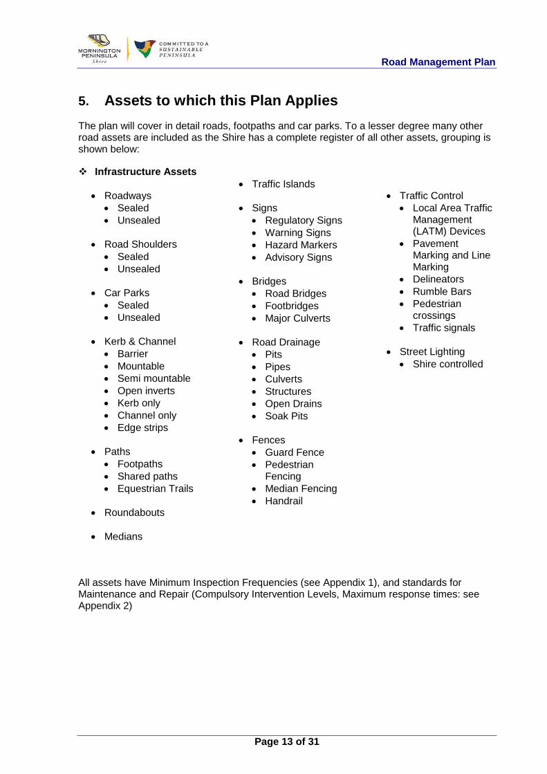
5. Assets to which this Plan Applies
The plan will cover in detail roads, footpaths and car parks. To a lesser degree many other road assets are included as the Shire has a complete register of all other assets, grouping is shown below:
v Infrastructure Assets
· Roadways · Sealed · Unsealed
· Road Shoulders
· Sealed · Unsealed
· Car Parks
· Sealed · Unsealed
· Kerb & Channel
· Barrier · Mountable · Semi mountable · Open inverts · Kerb only · Channel only · Edge strips
· Paths
· Footpaths · Shared paths · Equestrian Trails
· Roundabouts
· Medians
· Traffic Islands
· Signs
· Regulatory Signs · Warning Signs · Hazard Markers · Advisory Signs
· Bridges
· Road Bridges · Footbridges · Major Culverts
· Road Drainage
· Pits · Pipes · Culverts · Structures · Open Drains · Soak Pits
· Fences
· Guard Fence · Pedestrian
Fencing · Median Fencing · Handrail
· Traffic Control · Local Area Traffic
Management (LATM) Devices
· Pavement Marking and Line Marking
· Delineators · Rumble Bars · Pedestrian
crossings · Traffic signals
· Street Lighting
· Shire controlled
All assets have Minimum Inspection Frequencies (see Appendix 1), and standards for Maintenance and Repair (Compulsory Intervention Levels, Maximum response times: see Appendix 2)

Road Management Plan
Page 14 of 31
Local Arterial Road
Collector Road
Access Road
Access Road
Limited Access Track
Arterial Road (VicRoads)
5.1. Classification:
5.1.1. Road Hierarchy:
The Shire engaged ARRB Transport Research to investigate the functional hierarchy and service levels for sealed and unsealed roads.3 Working closely with Shire staff, and building on the experience from the Safer Local Roads contract, the following road classifications have been developed.
The purpose of a road hierarchy is to ensure that appropriate management, risk management, engineering standards and planning practices are applied to a road based on its function. It also enables more efficient use of limited resources by allocating funding to those roads that are in greater need and on which expenditure is better justified. The functional local road classifications cover both urban and rural areas. Shire officers have reviewed the road network and reclassified the hierarchy based on these functional types:
Figure 1: Schematic Diagram of MPSC Road Classification System – Rural
3 ARRB. (G. Giummarra). Report for MPSC – Development of Roads Classifications, Design
Standards, Maintenance/Intervention Levels and Access Provision Guidelines (2004).

Road Management Plan
Page 15 of 31
Table 1: Road Classifications in Rural Areas
Road Class Class Type Service Function
Description Brief Description RURAL AREAS
4A Rural Arterial Provides primarily for the main connection from town centres and local areas to the wider State main road network.
Two-way, two-lane, mainly sealed.
4B Rural Collector Provides for collecting and distributing traffic and acting as a feeder service to local arterial roads.
Two-way, two- lane, sealed or unsealed road.
4C Rural Access Provides predominantly for direct access to properties, recreational areas and industries in rural zones.
Two-way, mainly two-lane, sealed or unsealed road.
4CS Rural Access - Substandard
Provides similar functions to rural access roads, however not constructed to Shire standards but to a maintainable standard. Once the road becomes uneconomic to maintain it will be reclassified as 4CN
Generally a two lane, two-way sealed road not constructed to Shire standards.
4CN Rural Access - Not Maintainable
Provides similar functions to rural access roads, however not constructed to Shire standards and cannot be economically maintained.
Generally a single lane, two-way, unformed or unsealed road of low construction standards that cannot be economically maintained.
4D Rural Limited Access
Provides primarily for limited access and in rural areas using four wheel-drive vehicles.
Two-way, unformed, single lane road with limited geometry and possible access restrictions imposed.
4DS Rural Limited Access - Substandard
Provides similar functions to rural limited access roads, however not constructed to Shire standards but to a maintainable standard. Once the road becomes uneconomic to maintain it will be reclassified as 4DN
Generally a single lane, two-way, sealed road not constructed to Shire standards.
4DN Rural Limited Access - Not Maintainable
Provides similar functions to rural limited access roads, however not constructed to Shire standards and cannot be economically maintained.
Generally a single lane, two-way, unformed or unsealed road of low construction standards that cannot be economically maintained.

Road Management Plan
Page 16 of 31
Figure 2: Schematic Diagram of MPSC Road Classification System – Urban
Road Class Class Type Service Function
Description Brief Description URBAN AREAS
8A Urban Local Arterial
Provides primarily for the main connection from urban centres and local areas to the wider State arterial road network.
Generally a four-lane, or two-lane, two-way sealed road with parking provisions on both sides.
8B Urban Collector Provides for collecting and distributing traffic and acting as a feeder service to local arterial roads.
Mainly a two lane, two-way sealed road with commonly parking on one side.
8C Urban Access Provides predominantly for direct access to properties, recreational areas and industries in urban zones.
Generally a two lane, two-way sealed road, or unsealed road.
8CS Urban Access - Substandard
Provides similar functions to urban access road, however not constructed to Shire standards but to a maintainable standard. Once the road becomes uneconomic to maintain it will be reclassified as 8CN
Generally a sealed two-way road not constructed to Shire standards.
8CN Urban Access - Not maintainable
Provides similar functions to urban access roads, however not constructed to Shire standards and cannot be economically maintained.
Generally an unformed or unsealed two-way road of low construction standards that cannot be economically maintained.
8D Urban Limited Access
Provides primarily for limited access to rear of properties or within recreational parks
Generally a single lane, two way roads at the rear of properties or informal road within a recreational park.
8DS Urban Limited Access - Substandard
Provides similar functions to urban limited access road, however not constructed to Shire standards but to a maintainable standard. Once the road becomes uneconomic to maintain it will be reclassified as 8DN
Generally a sealed single lane, two-way road not constructed to Shire standards at the rear of properties.
8DN Urban Limited Access - Not maintainable
Provides similar functions urban limited access road, however not constructed to Shire standards and cannot be economically maintained.
Generally an unformed or unsealed single lane, two-way road of low construction standards that cannot be economically maintained.
access road
access road
Sta
te a
rter
ial r
oad

Road Management Plan
Page 17 of 31
Appropriate geometric design guidelines for Class A, B and C roads have been established. The standards take into account road user requirements relating to operational comfort, convenience and safety and the funding resources available to Council.
Maintenance intervention levels for sealed and unsealed road pavements are provided based on an extensive review of the maintenance of its assets. This review involved input from the community to ensure maintenance service standards and service levels reflected the expectations of the community.
5.1.2. Off-Street Car Park Hierarchy:
· CP 1 – High Profile Commonly an off-street sealed car park in a major commercial area.
· CP 2 – Low Profile
Commonly an off-street car park in other areas.
5.1.3. Path Hierarchy:
The Shire keeps a register of all footpaths and their classification. All paths are categorised as either a Shared Path, Residential, Foreshore, Park or Other. There are also High Profile paths that attract a higher level of inspection and maintenance. The list below details the types of path that are typically included in each classification, although this is not a definitive list. Residential, Commercial and Industrial Areas P 1 – High Profile A footpath immediately adjacent to:
· Large Township activity centres · Small Township activity centres · Local activity centres · Convenience centres · Schools · Child Care Centres · Kindergartens · Hospice & Palliative Care · Hospitals · Nursing Homes
P2 – Low Profile All other paths in a Residential, Commercial or Industrial area Shared Paths (includes Boardwalks) P1 – High Profile
· Any path that connects two townships · Any shared path that also fits the criteria for a high profile footpath.
P2 – Low profile
· All other paths

Road Management Plan
Page 18 of 31
Foreshore P1 – High Profile During daylight savings the following paths are considered high profile:
· Any path in a camping area · Bay trail · Hastings foreshore
P2 – Low Profile
· All other paths during daylight savings time · All paths are considered low profile outside daylight savings time
Parks P1 – High profile:
· Typically any path in park of regional significance P2 – Low profile
Any other path in a Shire park or reserve

Road Management Plan
Page 19 of 31
5.2. Register of Public Roads:
As a road authority the Shire must keep a Register of Public Roads in accordance with the Road Management Act to record the details of the Public Roads and Ancillary area for which it is responsible. Council must make a decision that the roads included in the Register are reasonably required for general public use. For further information refer to the Shire’s of Register of Public Roads Policy.
Roads for which Council is not the authority will either be the responsibility of other road authorities, e.g. VicRoads, Parks Victoria and Department of Sustainability & Environment. For a list of VicRoads roads refer to Appendix 3.
Council will not become the road authority for new subdivisions until all works are complete and are to Council’s standards.
The compilation of the register is an ongoing process of refinement with new assets coming on line all the time, plus newly found areas and dispute resolution between other road authorities.
A sample of the Register of Public Roads is shown below:
ROAD BLOCK ROAD ROAD LOCALITY ALTERNATIVE FROM TO LENGTH DATE
BECAME DATE
CEASED TO ROAD MAINT/CONTROL ANCILLARY AGREEMENTS, COMMENTS
ID ID NAME TYPE ROAD NAME PUBLIC ROAD
BE A PUBLIC ROAD CLASS DESCRIPTION AREAS PLANS ETC.
104827 1 SHAKTI PLACE HASTINGS TARA DVE TWAY END 124 1/7/2004 URBAN
ACCESS
304680 1 SHALIMAR COURT SORRENTO LADY
NELSON TWAY END 80 1/7/2004 URBAN
ACCESS
211650 1 SHANDON STREET MORNINGTON HERBERT LUCERNE 170 1/7/2004 URBAN
ACCESS
211650 2 SHANDON STREET MORNINGTON LUCERNE BELEURA HL 180 1/7/2004 URBAN
ACCESS
211650 3 SHANDON STREET MORNINGTON BELEURA HL AMELIA 117 1/7/2004 URBAN
ARTERIAL
211650 4 SHANDON STREET MORNINGTON AMELIA NEPEAN 242 1/7/2004 URBAN
ARTERIAL
204717 1 TANGERINE COURT MOUNT
MARTHA PAPERBARK TWAY END 99 1/7/2004 URBAN
ACCESS
118820 1 TANNENBAUM AVENUE MERRICKS
NORTH
OLD BITTERN-DROMANA TWAY END 472 1/7/2004
RURAL ACCESS
211100 1 BELEURA HILL ROAD MORNINGTON JOHN
ROWEL ROTHESAY 145 1/7/2004 URBAN
COLLECTOR
211100 2 BELEURA HILL ROAD MORNINGTON ROTHESAY CHANNEL 140 1/7/2004 URBAN
COLLECTOR

Road Management Plan
Page 20 of 31
6. Demarcation
6.1. State Roads:
Guidance on the physical limits of operational responsibility between VicRoads and municipal councils for different parts or elements of the road reserve of a Freeway or Arterial Road is provided in the Road Management Act Code of Practice – Operational Responsibility for Public Roads, Part 1.
6.1.1. Car Parking Bays on Arterial Roads:
VicRoads is responsible for any part of the roadway that could be used by through traffic. Distances of less than 200 metres are considered to be of limited use for through traffic.
Therefore the Shire is responsible on Arterial Roads for maintaining isolated parking areas of lengths less than 200 metres between kerb outstands.4
6.2. Boundary Roads:
The Shire has entered into agreements with abutting municipalities where a municipal road defines the boundary between the two Councils.
6.2.1. City of Frankston:
The Shire has a letter of agreement, dated 30 June 2004, with the City of Frankston concerning municipal boundary road responsibilities.
6.2.2. City of Casey:
The Shire has entered into a Memorandum of Understanding, dated 24 December 2004, with the City of Casey concerning the management of boundary roads.
6.3. Public Transport:
6.3.1. Bus Passenger Facilities:
Council has a contract with the Department of Transport for the supply and maintenance of bus shelters and some DDA compliant bus shelter pads at specific locations throughout the Shire.
4 Road Management Act 2004, Code of Practice for Operational Responsibility for Public
Roads (December 2004), p. 11.

Road Management Plan
Page 21 of 31
The service contract is for the full asset management of the shelters and pads, including routine maintenance along with cleaning and also periodic maintenance along with structural integrity maintenance.
Council also has and extensive network of DDA compliant bus stop pads and bus shelters that are not part of the abovementioned service contract. Council directly manages these pads and shelters with respect to asset management incorporating routine and periodic maintenance along with asset renewal.
6.3.2. Bus Bays:
Responsibilities for bus bays are described in RMA Code of Practice, Operational Responsibility for Public Roads, dated 17 December 2004.
6.3.3. Rail Tracks (Railway Level Crossings):
Responsibilities of public transport operators and the road authority for roads with rail crossings are set out in a Safety Interface Agreement (SIA) between the two parties. The SIA clearly defines which authority is responsible for maintenance and renewal of assets relating to rail crossings, both level and grade-separated.
6.4. Bridges:
See Definitions: Road infrastructure
The MPSC is responsible for inspecting, maintaining and repairing all road bridges, including pathways, on Municipal Roads within the Shire on its Register of Public Roads
6.5. Street Lighting:
Standard street lighting is generally the responsibility of the electrical distribution business.
The Shire is responsible for the maintenance of non-standard lighting in specific areas such as subdivisions.
The Shire works with the relevant electrical authority to ensure the regular inspection and repair or replacement of such lights and poles as required.
6.6. Utilities:
The Shire and utilities work together cooperatively to facilitate the installation, maintenance and operation of road and non-road infrastructure within road reserves. This work is undertaken in accordance with the Road Management Act 2004, Code of Practice for Management of Infrastructure in Road Reserves.
6.7. Vehicle Crossings:
The Road Management Act provides that a road authority is not liable for private vehicle crossings (driveways). This applies in both urban and rural areas.

Road Management Plan
Page 22 of 31
This is consistent with the general principle in the Road Management Act that the owner of an asset is responsible for the condition and maintenance of that asset. This does not, however, prevent the Council from imposing conditions on the construction of a driveway.
The adjacent property owner is responsible for the construction and maintenance of their vehicle crossing, including the pathway section and the adjacent kerb and channel. The property owner is also responsible for pathways on road reserves that provide access to land adjoining a road.
The adjacent property owner is responsible for a culvert crossing including end walls.
Vehicle crossings must comply with the relevant Shire Policy
For further details refer to the Shires’ Register of Public Roads Policy.5
6.8. Paths:
The Shire is responsible for all paths on its reserves and road reserves that appear on its asset register.
For a definition of Foot trodden track refer to the Road Management Act
6.9. Equestrian Trails:
The Shire will only be responsible for Designated Equestrian Trails constructed or developed by the Shire for use by members of the public with horses.
A horse trodden track over roadside land is not an Equestrian Trail.
6.10. Roadsides:
The statutory duty imposed by the Road Management Act to inspect does not apply to any roadside that has not been developed by a road authority for use by the public as a roadway or pathway. A road authority is not under a duty to maintain roadside bushland.6
At its discretion, the Shire has included some parks and roadsides standards in this Road Management Plan as it is considered that they may affect the safety of road users.
5 Mornington Peninsula Shire Council. Register of Public Roads Policy – Background
Paper (adopted by Council 24 March 2008), p. 8. 6 Road Management Act 2004, s. 40(4)(b), s. 107.

Road Management Plan
Page 23 of 31
7. Levels of service
7.1. Specifications and Standards:
The Shire has specifications and standards for constructed assets that are the Shire’s responsibility, or will become so. The standards cover all areas of construction, OH&S, traffic management and quality systems. The Development Engineer and Construction and Asset Protection Unit work together to ensure that new assets are constructed to these specifications and standards and after the assigned maintenance period make sure the assets at handover are serviceable. The specifications and standards can be viewed at our web site - http://www.mornpen.vic.gov.au .
7.2. Inspection and Maintenance:
The Shire has a process in place for inspection frequencies, intervention levels and time to complete works. Higher risk areas have a higher inspection frequency, tighter intervention levels and quicker response times, e.g. footpaths around schools or shopping centres are inspected more frequently than footpaths in residential areas. The response times have been developed giving consideration to matters such as the type of infrastructure, public usage, community expectations, risk analysis, and the resources available. Nominated inspection and audit regimes are an integral part of pro-active service delivery and risk management.
The nominated response times have been developed as a maximum response time that will be achieved at all times in all circumstances within the control of the Shire. It is not the desirable level of service but a level of service that it is intended to achieve in all circumstances. In most circumstances it is expected that a higher level of service will be achieved. Refer to Events Beyond Control of Council: on page 25.
The Shire’s service providers must plan and implement programs of inspections of the road network which:
· are undertaken at an agreed minimum frequency, · identifies defects, · prioritises defects giving consideration to potential risk, · are responsive to reports or complaints, · are carried out at intervals designed to establish programs of periodic
maintenance.
The Shire’s service providers respond to three types of inspections:
7.2.1. Programmed Inspections
Where each asset type is inspected at a specified minimum frequency, the minimum frequency of inspection for all road infrastructure assets can be viewed in Appendix 1

Road Management Plan
Page 24 of 31
7.2.2. Reactive Inspections
Inspections of individual assets are undertaken in response to reports, complaints, notifications or other representations made to the Shire or inspections by work crews.
The following road classes are only inspected reactively:
· 4CN: Rural access – not maintainable
· 4DN: Rural limited access – not maintainable
· 8CN: Urban access – not maintainable
· 8DN: Urban limited access – not maintainable
7.2.3. Triggered Inspections
Inspections of certain assets following defined events notified to the Shire or of which the Shire is aware. These could include events such as the movement of an abnormally heavy load, a road opening, special event, or events likely to cause defects in an asset.
7.3. Standards of Maintenance and Repair:
A table of Standards of maintenance and repair, including compulsory intervention levels and maximum response times can be viewed in Appendix 2.
7.3.1. Unmaintainable Roads
Standards for maintenance and repair for unmaintainable (Type 4CN, 4DN, 8CN and 8DN roads) will be as follows:
· Only a minimal standard of maintenance will be delivered.
· An attempt will be made to make a road passable by a standard model two-wheel drive vehicle (e.g. Ford Falcon, Holden Commodore) at very low speed in the following circumstances:
Ø Primary access to a property where people reside.
Ø Dry weather access only.
Ø Work can be undertaken economically within available road maintenance resources.
· The road will not be upgraded or maintained to a higher standard than the standard to which the road is constructed.
· Response time for reactive inspections: 7 days.
· Response time for repairs or making safe: 28 days.

Road Management Plan
Page 25 of 31
7.3.2. Car Parks
Standards for Maintenance and Repair for Car Parks will be as follows:
· High Profile Off-Street Car parks ( CP 1) are the same as Type B roads.
· Other Off-Street Car parks (CP 2) are the same as Type C roads.
· On-street car parks are the same as Type C roads, unless nominated as a CP 1 classification in the Register of Public Roads.
7.4. Reseal and Rehabilitation:
The Safer Local Roads service provider’s Pavement Management System is utilised to determine the annual local sealed roads reseal and rehabilitation program (see 3.3 Works:). Factors taken into account when optimising expenditure to achieve SLR pavement performance outcomes are roughness, rutting, surface texture depth, crocodile cracking, pavement defects, flushing, stripping, surface age and traffic loading. Various surface and pavement treatment options are considered in order to achieve best performance outcomes.
The current status of the local sealed road network within SLR is indicated by the Pavement Condition Index (PCI), an index that takes into account condition related data. The PCI is a useful method for comparison of the network condition during three year assessment cycles, however it cannot be used as a ‘universal’ scale of comparison between other municipalities.
7.5. Events Beyond Control of Council:
Council will make every endeavour to meet all aspects of its Road Management Plan. However in the event of natural disasters and events but not limited to fires, wind storms and floods, as well as human factors, but not limited to lack of Council staff or suitably qualified contractors, because of Section 83 of the Victorian Wrongs Act, 1958, as amended, Council reserves the right to suspend compliance with its Road Management Plan.
In the event that the Chief Executive Officer of Council, has to, pursuant to Section 83 of the said Act, consider the limited financial resources of Council and its other conflicting priorities, meaning Council’s Road Management Plan cannot be met, they will write to Council’s Officer in charge of its Road Management Plan and inform them that some, or all of the timeframes and responses in Council’s Road Management Plan, are to be suspended.
Once the events beyond the control of Council have abated, or if the events have partly abated, Council’s Chief Executive Officer will write to Council’s Officer responsible for Council’s Road Management Plan and inform them which parts of Council’s Road Management Plan are to be reactivated and when.

Road Management Plan
Page 26 of 31
8. Data Management System
Service Providers are responsible for the maintenance of roads, footpaths, kerb & channels, bridges, major culverts and other infrastructure assets. To achieve the contract standards and inspection frequencies the service providers have implemented various systems. The Safer Local Roads contractor runs a maintenance management system that follows works from inception to completion. Inspectors have Global Positioning System (GPS) handheld technology in the field so that each defect for roads, footpaths and kerb & channels is mapped and prioritised. This is an effective way of logging a defect to a point on the asset. For example, a pot hole is located by GPS and thereby linking the defect to the road block, so that each defect is logged against an asset. This means it is there for future reference, such as supervisor audit, customer inquiry or, if it is a failure that happens repeatedly, then further investigation can be carried out. Once inspections are complete the inspectors upload their data directly into the system which produces work schedules based on compliance with intervention levels and response times. A completion date is entered into the system when works are complete. This can then be archived and will be used for the supervisors to audit and for future use to use in road modelling. The Parks and Roadsides team maintain and update a historical reference of identified trees (trees inspected). The trees are individually identified via a unique barcode number. Information includes details such as tree species, tree height, GPS location and previous maintenance, to name a few. This database is known as the Tree Risk Database.

Road Management Plan
Page 27 of 31
Following is the flowchart of maintenance works as provided by a Service Provider.
In the case of customer request or staff initiated activities; they will be generated by the Shire’s customer service software Merit. The Safer Local Roads service provider will tag all works generated via Merit with a customer request ID so that the activity is tracked from inception to completion. Giving a full history as described earlier for feedback to customers if required. This data can also be used by the contracts supervisor for auditing quality of works, response times and customer relations.

Road Management Plan
Page 28 of 31
9. Plan Improvement and Monitoring
The area of roads and asset management has been rapidly changing over several years and will continue to do so in the future. Therefore there is a need to continually improve the Shire’s Road Management Plan and to update amendments as required by the Road Management Act. Improvement will come from monitoring changes in:
· Legislation · Technology · Community needs · Methodology · Resources · Liability claims · Dispute resolution and · Agreement finalisation.
The Plan will be reviewed in compliance with legislation and any changes or amendments made will be put forward for public review and gazettal as required

Road Management Plan
Page 29 of 31
10. Glossary
The following terms are used in this Road Management Plan.
TERM MEANING AS USED IN THIS PLAN
Day Refers to all calendar days
Week Refers to 7-day week
Month Refers to calendar month.
Year Refers to calendar year.
Bridge Includes all structures, including culverts, on, over or under a road that have a single span or diameter of 1.8 metres or greater, or have a waterway area of 3 m2 or greater and includes all structural components (e.g. abutments, retaining walls, traffic safety barriers), and associated pathways, within the limits of the structure, but excludes approach embankments.
Public Road A road that the Council decides is reasonably required for general public use and is then registered on the Shire’s Register of Public Roads.
Repair The taking of any action to remove or reduce a risk arising from a defect, including – (a) reinstating a road to its former standard. (b) providing a warning to road users of a defect.
Road Any public highway; Any ancillary area; Any land declared to be a road under section 11 of the RMA or forming part of a public highway or ancillary area.
Road Reserve All the area of land that is within the boundaries of a road.
Roadside Any land that is within the boundaries of a road (other than the shoulders of the road) which is not a roadway or a pathway and includes the land on which any vehicle crossing or pathway which connects from a roadway or pathway on a road to other land has been constructed; Example: Any nature strip, forest, bushland, grassland or landscaped area within the road reserve would be roadside.
Roadway (a) In the case of a public road, the area of the public road that is open to or used by members of the public and is developed by a road authority for the driving or riding of motor vehicles;
(b) In the case of any other road, the area of the road within the meaning of road in section 3(1) of the Road Safety Act 1986 —

Road Management Plan
Page 30 of 31
but does not include a driveway providing access to the public road or other road from adjoining land;
Vehicle Crossing An improved area between the carriageway of any Road to the adjacent property line of private property and includes culverts, kerb and channel laybacks and pavement thickening of footways, that provides safe, all weather access to properties and prevents damage to services and other assets located within the Road Reserve.7
7 • Mornington Peninsula Shire Council. Local Law No. 5 – Streets and Roads (2005).

Road Management Plan
Page 31 of 31
11. Appendices