room to move. towards a strategy to assist the adelaide
TRANSCRIPT

DWLBC REPORT
Room to move
Towards a strategy to assist
the Adelaide Hills apple
industry adapt to climate
change in a contested
peri-urban environment
2008/20

Room to move
Towards a strategy to assist the Adelaide Hills apple industry adapt to climate change in a contested peri-urban environment
Peter Houston (PIRSA) and Jan Rowland (DWLBC) with input from Douglas Bardsley, Susan Sweeney and David Maschmedt (DWLBC); Peter Hayman and Uday Nidumolu (SARDI); Paul James and Amy Williams (Rural Solutions SA); Trevor Ranford (APGA of SA); Penny Baldock, Peter Willmott and John Fennell (PIRSA); Bruce Brooks and Darren Ray (BoM); Gayle Greiger and Karen Hollamby (AMLR NRM Board).
Land and Biodiversity Services Department of Water, Land and Biodiversity Conservation
April 2008
Report DWLBC 2008/20

Land and Biodiversity Services Department of Water, Land and Biodiversity Conservation 25 Grenfell Street, Adelaide GPO Box 2834, Adelaide SA 5001 Telephone National (08) 8463 6946 International +61 8 8463 6946 Fax National (08) 8463 6999 International +61 8 8463 6999 Website www.dwlbc.sa.gov.au Disclaimer The Department of Water, Land and Biodiversity Conservation and its employees do not warrant or make any representation regarding the use, or results of the use, of the information contained herein as regards to its correctness, accuracy, reliability, currency or otherwise. The Department of Water, Land and Biodiversity Conservation and its employees expressly disclaims all liability or responsibility to any person using the information or advice. Information contained in this document is correct at the time of writing. © Government of South Australia, through the Department of Water, Land and Biodiversity Conservation 2008 This work is Copyright. Apart from any use permitted under the Copyright Act 1968 (Cwlth), no part may be reproduced by any process without prior written permission obtained from the Department of Water, Land and Biodiversity Conservation. Requests and enquiries concerning reproduction and rights should be directed to the Chief Executive, Department of Water, Land and Biodiversity Conservation, GPO Box 2834, Adelaide SA 5001. ISBN 978-1-921528-09-5 Preferred way to cite this publication Houston P & Rowland J, 2008, Room to move. Towards a strategy to assist the Adelaide Hills apple industry adapt to climate change in a contested peri-urban environment, DWLBC Report 2008/20, Government of South Australia, through Department of Water, Land and Biodiversity Conservation, Adelaide.
Report DWLBC 2008/20 Room to move. Towards a strategy to assist the Adelaide Hills apple industry adapt to climate change in a contested peri-urban environment
iii
FOREWORD
South Australia’s unique and precious natural resources are fundamental to the economic and social wellbeing of the state. It is critical that these resources are managed in a sustainable manner to safeguard them both for current users and for future generations.
The Department of Water, Land and Biodiversity Conservation strives to ensure that our natural resources are managed so that they are available for all users, including the environment.
In order for us to best manage these natural resources it is imperative that we have a sound knowledge of their condition and how they are likely to respond to management changes. The Department of Water, Land and Biodiversity Conservation’s scientific and technical staff continues to improve this knowledge through undertaking investigations, technical reviews and resource modelling.
Arguably the most fundamental challenge in managing these natural resources is that posed by climate change. This report describes one of a series of case studies conducted as part of a wider project titled A regional climate change decision framework for natural resource[s] management. The intention of this larger project has been to work with the Adelaide and Mount Lofty Ranges Natural Resources Management Board to: • undertake an assessment of key areas of natural resources management that are
vulnerable to climate change
• develop and demonstrate methodologies for creating a regional decision framework for wider application in managing climate change risk and developing adaptation responses.
The case studies were identified after an initial analysis of vulnerability to climate change within the Adelaide and Mt Lofty Ranges Natural Resources Management region (Bardsley 2006). Each case study examines methodologies relevant to the various natural resources management sectors with the intention of developing a regional natural resources management response to climate change risk.
Rob Freeman CHIEF EXECUTIVE DEPARTMENT OF WATER, LAND AND BIODIVERSITY CONSERVATION

Report DWLBC 2008/20 Room to move. Towards a strategy to assist the Adelaide Hills apple industry adapt to climate change in a contested peri-urban environment
iv
Report DWLBC 2008/20 Room to move. Towards a strategy to assist the Adelaide Hills apple industry adapt to climate change in a contested peri-urban environment
v
ACKNOWLEDGEMENTS
This report was produced with generous contributions from Douglas Bardsley, Susan Sweeney, David Maschmedt and Andrew Fisher (Department of Water, Land and Biodiversity Conservation); Peter Hayman and Uday Nidumolu (South Australian Research and Development Institute); Paul James and Amy Williams (Rural Solutions SA); and Trevor Ranford (Apple and Pear Growers Association of SA Inc). Other contributors include: Penny Baldock, Peter Willmott and John Fennell (Primary Industries and Resources South Australia); Bruce Brooks and Darren Ray (Bureau of Meteorology); Gayle Greiger and Karen Hollamby (Adelaide and Mount Lofty Ranges Natural Resources Management Board); and Paul Mickan, Senior Strategic & Statutory Planner, Adelaide Hills Council.
Many thanks to Scott Douglas and Sue Giles, Planning SA, for reviewing the report.
This work has been financially supported by the SA Department of Water, Land and Biodiversity Conservation, by the Australian Government through the Department of Climate Change, (formerly the Australian Greenhouse Office in the Department of the Environment and Water Resources), and by the AMLR NRM Board.

Report DWLBC 2008/20 Room to move. Towards a strategy to assist the Adelaide Hills apple industry adapt to climate change in a contested peri-urban environment
vi
Report DWLBC 2008/20 Room to move. Towards a strategy to assist the Adelaide Hills apple industry adapt to climate change in a contested peri-urban environment
vii
CONTENTS
FOREWORD........................................................................................................................... iii
ACKNOWLEDGEMENTS........................................................................................................v
SUMMARY...............................................................................................................................1
1. INTRODUCTION...............................................................................................................3
2. AIM AND OBJECTIVES ...................................................................................................9
3. METHODOLOGY............................................................................................................11
3.1 BACKGROUND........................................................................................................11 3.2 SUMMARY OF METHODOLOGY............................................................................21
4. RESULTS........................................................................................................................27
5. DISCUSSION ..................................................................................................................31
6. CONCLUSIONS AND RECOMMENDATIONS...............................................................33
APPENDICES........................................................................................................................35
A. PROJECT MEETINGS AND PRESENTATIONS.....................................................35 B. PEER REVIEW – INDUSTRY EXPERTS ................................................................36 C. TECHNICAL REVIEW – CLIMATE SCIENCE .........................................................38 D. ADDITIONAL MAPS.................................................................................................40
UNITS OF MEASUREMENT .................................................................................................43
GLOSSARY ...........................................................................................................................45
REFERENCES.......................................................................................................................47

CONTENTS
Report DWLBC 2008/20 Room to move. Towards a strategy to assist the Adelaide Hills apple industry adapt to climate change in a contested peri-urban environment
viii
LIST OF FIGURES
Map 1. Mean annual rainfall, South Australia (Source: DWLBC) ......................................4 Map 2. Pome (apple and pear) fruit production areas in the Adelaide Hills (Source: EPA)5 Map 3. Rural dwelling construction in Adelaide’s peri-urban region, 1985–2005 (Source:
Houston & Baldock 2008) ......................................................................................6 Map 4. Bureau of Meteorology monitoring sites for temperature.....................................12 Map 5. Bureau of Meteorology monitoring sites for rainfall .............................................13 Map 6. Land capability classes for apples .......................................................................15 Map 7. Groundwater salinity and yield.............................................................................15 Map 8. Average wet season (April–October) rainfall .......................................................16 Map 9. Average wet season (May–November) rainfall ....................................................16 Map 10. Average dry season (November–March) rainfall .................................................17 Map 11. Average dry season (December–April) rainfall ....................................................17 Map 12. Average minimum temperature of the coldest month in autumn .........................18 Map 13. Average minimum temperature of the coldest month in winter............................18 Map 14. Average minimum temperature of the coldest month in spring ...........................19 Map 15. Average maximum temperature of the warmest month in spring ........................19 Map 16. Average maximum temperature of the warmest month in summer .....................20 Map 17. Average maximum temperature of the warmest month in autumn ......................20 Map 18. Pome fruit production areas and land capability classes 1 and 2 for apples .......22 Map 19. Current resource availability for high quality apple production using selected
criteria ..................................................................................................................22 Map 20. Future resource availability for high quality apple production using selected
criteria ..................................................................................................................24 Map 21. Comparison of current and future resource availability for high quality apple
production ............................................................................................................24 Map 22. Current and future resource availability modified by excluded areas and existing
orchards...............................................................................................................26 Map 23. Land unavailable for future apple production due to rural residential development
(Source: AMLR NRM land use mapping, 2008) ..................................................26 Map 24. Current and future resource availability in the Adelaide Hills modified by excluded
areas, rural residential development, native vegetation and existing orchards ...29
LIST OF TABLES
Table 1. Data sets used in GIS modelling .........................................................................14
Report DWLBC 2008/20 Room to move. Towards a strategy to assist the Adelaide Hills apple industry adapt to climate change in a contested peri-urban environment
1
SUMMARY
Located on the eastern edge of the Adelaide and Mount Lofty Ranges Natural Resources Management (AMLR NRM) region, the Adelaide Hills are an ‘island’ of high rainfall, cool-climate conditions in an otherwise dry state. For South Australia’s apple industry, the Adelaide Hills are its key asset. The region generates on average 85% of the state’s total pome (apple and pear) fruit production and most of its premium quality fruit. In 2005–06, this share of production was worth about $25.5 million (PIRSA 2006). Other production districts are comparatively minor elements of the industry in South Australia and could not fully replicate the role of the Adelaide Hills.
Anticipated climate change seems likely to shrink the already limited opportunities for high quality apple production in the AMLR region. This will restrict the industry’s ability to adapt by relocating or reconfiguring itself, as suggested in a recent discussion paper prepared for the Primary Industries Standing Committee (Department of Primary Industries 2007). Peri-urban pressures, and especially rural residential development, will further narrow those options and amplify the effect of climate change. In these circumstances there would seem to be a risk of the industry being squeezed out of existence unless strategic action is taken soon.
There appears to be a sound prima facie argument for employing land use policy to secure key resources for the industry. However, the credibility of any policy prescription will depend on a robust understanding of both the sensitivity of Adelaide Hills’ apple production to current climate and climate change, and the resources available to industry in future. To investigate those matters this project used geographic information system (GIS) techniques to develop an interactive model of high quality apple production in the AMLR region.
Provisional findings suggest that there is currently an area of 20 300 ha in the AMLR region with bioclimatic conditions (ie. soils, water, rainfall and temperature) broadly similar to the Lenswood Valley, where apple production currently occurs. Based on assumptions about how climate change will manifest itself in a scenario of 1°C warming (by 2030) for a small bioclimatic ‘island’ like the Adelaide Hills, the model predicts future resource availability will shrink to 9000 ha. After accounting for urban areas, public land, major infrastructure, zoning constraints, native vegetation and ad hoc rural residential development, the figures for current and future resource availability fall to 11 400 and 4200 ha respectively. Because both of these figures include the 1750 ha of current production areas, the area of potential new production sites is correspondingly smaller again.
These assessments are very probably conservative (ie. overestimates of resource availability). They do not yet account for the possibility of future water quality protection policies in the Mount Lofty Ranges water catchment or the indirect effects of ad hoc rural residential development. Neither do they attempt to estimate the likely consequences of continuing rural residential development across the region or competition from other primary industries, such as wine grapes and forestry. In these circumstances the case for utilising land use policy to reserve key resources for the apple industry in the AMLR region seems compelling.
However, as emphasised throughout the report, the analysis behind this conclusion would benefit from further refinement. The model is currently limited by problems associated with the availability, quality and scale of climate and natural resource data. A second phase of
SUMMARY
Report DWLBC 2008/20 Room to move. Towards a strategy to assist the Adelaide Hills apple industry adapt to climate change in a contested peri-urban environment
2
project development would provide an opportunity to address those data problems. It would also provide an opportunity to engage with and seek expert input from a range of other potential project participants and stakeholders, including the Bureau of Meteorology (BoM), South Australian Research and Development Institute (SARDI) and growers. Continuing to develop the project in this way would enable policy makers to use the findings of this case study with greater confidence when considering regional-scale adaptation issues for agricultural industries generally.
The report recommends that the AMLR NRM Board: 1. carry on the task of developing and refining the model
2. seek to engage industry and relevant planning authorities in considering appropriate land use policy responses.

Report DWLBC 2008/20 Room to move. Towards a strategy to assist the Adelaide Hills apple industry adapt to climate change in a contested peri-urban environment
3
1. INTRODUCTION
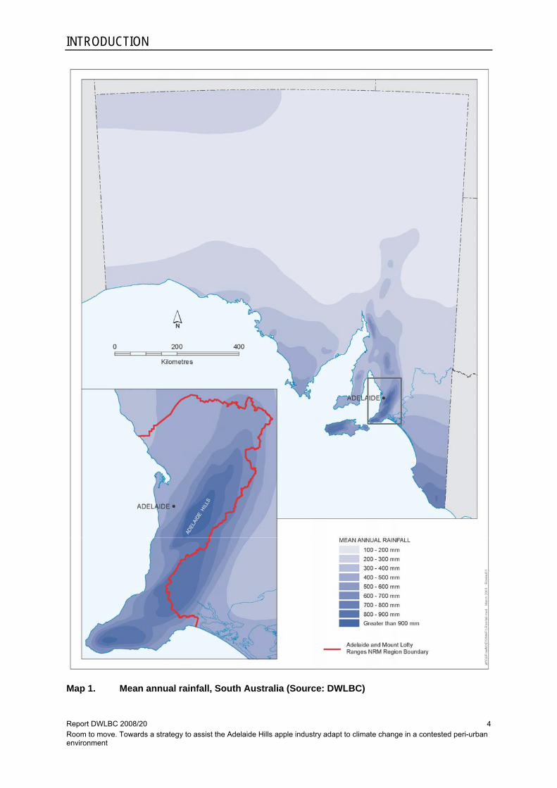
Located on the eastern edge of the Adelaide and Mount Lofty Ranges Natural Resources Management (AMLR NRM) region, the Adelaide Hills1 are an ‘island’ of high rainfall, cool-climate conditions in an otherwise dry state (Map 1). Compared to South Australia’s other main cool-climate region in the South-East, the Hills also enjoy better soil drainage and superior conditions for ripening of fruit (Paul James [Rural Solutions SA], pers. comm., [8 March 2005]). The scarcity of these conditions make this ‘island’ a key resource for the state’s food and wine sectors, especially premium, cool-climate horticulture.
For South Australia’s apple industry, the Adelaide Hills are its key asset. The region generates on average 85% of the state’s total pome (apple and pear) fruit production and most of its premium quality fruit (Trevor Ranford [APGA of SA], pers. comm., [31 October 2006]). This share of production was worth about $25.5 million in 2005–06.2 The Riverland and South-East produce early- and late-season fruit respectively but these are comparatively minor elements of the South Australian industry. It is unlikely that either could fully replicate the role of the Adelaide Hills as the key production district, and any significant loss of capacity in the Hills would jeopardise the South Australian industry as a whole.
The Lenswood Valley, located in the heart of the Adelaide Hills, is the traditional centre of this industry. The combination of favourable soil, rainfall and temperature conditions, along with reliable groundwater, has seen the development of a major apple production district comprising about 1750 ha of orchards over the past 100 years (Map 2). The presence of those orchards has led, in turn, to the establishment of an extensive local support infrastructure for the apple industry, including significant technical expertise and a strong industry culture. These features have enabled Adelaide Hills’ apple growers to be not just productive but competitive too.3
Anticipated climate change poses no immediate threat to production in the Lenswood Valley because existing management systems provide scope for coping with any short-term effects (Trevor Ranford [APGA of SA], pers. comm., [31 October 2006]). However, it does introduce uncertainty about the long-term availability of suitable sites for high quality apple production in the AMLR region. Given the constrained nature of the resource on which the industry relies, and the presence of other climate-sensitive NRM sectors in this ‘island’, such as biodiversity, climate change seems likely to shrink its already limited opportunities in South Australia. This would restrict the industry’s ability to adapt by relocating or reconfiguring4 itself across the landscape, as suggested in a recent discussion paper prepared for the Primary Industries Standing Committee (Department of Primary Industries 2007). 1 There is no precise definition of the Adelaide Hills but the region is generally understood to comprise that part of the Mount Lofty Ranges immediately adjacent to the Adelaide metropolitan area. 2 According to the SA Food Industry Scorecards project, total South Australian pome fruit production in 2005–06 was valued at $30 million (PIRSA 2006). Because the Adelaide Hills produce the bulk of premium quality fruit, $25.5 million may be a conservative estimate of production by value. 3 In recent years a number of Adelaide Hills growers have secured export contracts to supply UK retailers with Pink Lady apples (Trevor Ranford [APGA of SA], pers. comm., [26 February 2008]). 4 These two terms seek to distinguish between adaptation responses that involve a wholesale relocation of apple production to other parts of the region or the state; and those that require only a reconfiguration of current production areas, utilising parts of the local landscape not currently occupied by apple orchards but likely to be suitable in future climate scenarios. These two responses are variations along a spectrum of adaptation options and may coexist in time and space.
INTRODUCTION
Report DWLBC 2008/20 Room to move. Towards a strategy to assist the Adelaide Hills apple industry adapt to climate change in a contested peri-urban environment
4
Map 1. Mean annual rainfall, South Australia (Source: DWLBC)

INTRODUCTION
Report DWLBC 2008/20 Room to move. Towards a strategy to assist the Adelaide Hills apple industry adapt to climate change in a contested peri-urban environment
5
Map 2. Pome (apple and pear) fruit production areas in the Adelaide Hills (Source: EPA)
These circumstances would be difficult enough on their own but in the Adelaide Hills, and the AMLR region generally, primary production faces additional difficulties arising from its proximity to the metropolitan area. Land use conflict and escalating land values associated with urban encroachment have the effect of further limiting the industry’s room to manoeuvre; the pending introduction of revised catchment management policies to protect metropolitan water supplies may do the same. Whatever narrowing of opportunities might be attributable to climate change, peri-urban pressures will amplify that effect, as illustrated by the analysis of rural dwelling construction activity shown in Map 3. In these circumstances there would seem to be a very real risk of the industry being squeezed out of existence unless strategic action is taken soon.
Successful adaptation to climate change by the Adelaide Hills apple industry is likely to require action at a variety of scales. Some of those responses are already part of industry research and development programs and would be very familiar to growers. For example, conversion to alternative varieties and adoption of protective measures such as netting seem to have good potential to ameliorate the impacts of the extreme weather events in the short-term.

INTRODUCTION
Report DWLBC 2008/20 Room to move. Towards a strategy to assist the Adelaide Hills apple industry adapt to climate change in a contested peri-urban environment
6
Map 3. Rural dwelling construction in Adelaide’s peri-urban region, 1985–2005 (Source:
Houston & Baldock 2008) Note: Map 3 is part of a time-series analysis and shows the 30% increase in ad hoc rural dwellings that occurred in Adelaide’s peri-urban region over the 20-year study period. An analysis of rural dwelling construction in the AMLR NRM region (shown in blue) would likely show a similar increase.

INTRODUCTION
Report DWLBC 2008/20 Room to move. Towards a strategy to assist the Adelaide Hills apple industry adapt to climate change in a contested peri-urban environment
7
However, property-scale responses may be inadequate over the long-term or under conditions of scarcity and competition for resources, as is the case in the Adelaide Hills. Those scenarios are likely to require regional-scale responses that address the fundamental issue of resource availability and utilise land use policy to ensure industries have long-term access to resources.
Although various commonwealth and state government documents relating to climate change anticipate this type of adaptation (COAG 2007; Department of Primary Industries 2007; Natural Resource Management Ministerial Council 2006; Sustainability and Climate Change Division 2007), there is little evidence of its conceptual development or practical application. This situation limits the range of responses that can be adopted by agricultural industries in developing a climate change adaptation strategy. To help address that gap, this project undertook a case study analysis of the regional-scale adaptation issues faced by the Adelaide Hills apple industry. While the findings produced are specific to that industry, they nevertheless shed light on the situation for vulnerable industries generally, and especially on the question of future resource availability and its implications for land use policy.
Statutory land use planning is an obvious tool for reserving land suitable for future apple production. South Australian Development Plans have identified ’deferred urban’, ‘deferred residential’ and ‘deferred industry’ zones for many years and, more generally, the planning system has traditionally sought to promote ’orderly, economic and efficient’5 patterns of development. These features are clearly intended to avoid foreclosing land use options and make provision for future circumstances. It would be a small step conceptually and practically to use land use policy in the same way to assist primary production to adapt to climate change.
Of course, the cost-benefit argument for reserving or protecting agricultural land resources in this way needs to be made in each case: a strong argument may not exist where there is no scarcity or resource competition, or where the industry in question is very minor or has only a limited strategic outlook.6 In this particular case there does appear to be a sound prima facie argument for employing land use policy. Nevertheless, the credibility of any policy prescription will depend on a robust understanding of both the sensitivity of Adelaide Hills apple production to current climate and climate change, and the resources available to industry in the future.
To investigate those matters this project used GIS techniques to develop an interactive model of high quality apple production in the AMLR region. Importantly, the intention of this exercise was not to make precise predictions about the long-term fate of particular parcels of land: rather, it simply sought to help stakeholders understand the potential scale of changes to resource availability in a scenario of 1°C warming (by 2030), and the broad pattern of that 5 The latest version of Planning SA’s Better Development Plan (BDP) library speaks of ‘orderly and sustainable’ development, http://www.planning.sa.gov.au/go/development-plans/better-development-plans-project/bdp-policy-library-and-guides. 6 Another reason for using land use policy in this way is that failing to do so may prematurely foreclose future resource use options and industries that have yet to be considered: options and industries that will only become apparent in years to come as the challenge of climate change unfolds. From this perspective, long-term risk management, rather than contemporary cost-benefit analysis, may be a more relevant basis for decision-making when considering regional-scale adaptation. Long-term risk management is not explored here because of the industry specific nature of this project. However, in a more generalised assessment of adaptation options for primary production at large it would be as important, if not more important, than cost-benefit analysis.

INTRODUCTION
Report DWLBC 2008/20 Room to move. Towards a strategy to assist the Adelaide Hills apple industry adapt to climate change in a contested peri-urban environment
8
change. Limitations in available data and the current state of climate change modelling prevent anything more sophisticated.
The following sections set out and explain the aims and objectives for the project, the methodology used and the main outputs and findings, before a discussion of key issues raised and a conclusion that includes a number of recommendations.
Report DWLBC 2008/20 Room to move. Towards a strategy to assist the Adelaide Hills apple industry adapt to climate change in a contested peri-urban environment
9
2. AIM AND OBJECTIVES
The general aim of this project was to investigate the case for a regional-scale climate change response by the Adelaide Hills apple industry, one that would allow for future relocation or reconfiguration of orchards by using land use policy to reserve key resources. As mentioned previously, this type of adaptation response is anticipated in a number of key climate change policy documents but there is little evidence of its conceptual development or practical application. Lack of knowledge about this type of response will limit the agricultural sector in its adaptation efforts.
Testing the case for such a response in the AMLR region will allow local stakeholders to better understand the necessary features of an overall climate change strategy for the apple industry. More generally, it will inform the adaptation efforts of other industries and regions where this type of regional-scale response may be needed. To undertake this investigation, the project had a secondary aim to develop an interactive GIS model to provide stakeholders with a better understanding of resource availability for apple production under current and future climate conditions. These two areas of inquiry became the first two objectives of the project.
The first objective was to form a better understanding of current resource availability for apple production in the AMLR region and, related to this, the extent to which high quality apple production is climatically ‘elastic’. While current limits to production may be understood intuitively by the industry and by individual growers, it is unlikely that the wider community is aware of those constraints. Undertaking this analysis will enable a more informed assessment of the general context for adaptation by the apple industry, including the case for using land use policy to reserve key resources.
This objective comprised two distinct elements: analysis of the AMLR region to identify the extent of the bioclimatic envelope with conditions similar to the Lenswood Valley; and an expert-based review of whether there is more scope (‘elasticity’) for high quality apple production in the region than this analysis suggests. With adequate climate and natural resource data the former is a relatively straightforward exercise. The latter would ideally be the subject of a long-term research project based on trial plantings and detailed climate monitoring across the region, but in the circumstances must rely on inferences from research in other regions and industries, and the advice of experts. As such, it is less likely to produce a definitive finding and will probably be contentious. Nevertheless, it is a necessary task for climate-sensitive industries wanting to consider the full range of adaptation options.
The second objective was to form a better understanding of possible future resource availability scenarios under projected climate change. Ordinarily this would be difficult, if not impossible, given the absence of fine resolution climate projections in Australia (Suppiah et al. 2006). However, a relatively small bioclimatic ‘island’ such as the Adelaide Hills, where climate and elevation are strongly correlated, lends itself to simulation of the circumstances that could reasonably confront the apple industry. In particular, future resource availability can be simulated by nominating incremental changes in temperature, based on projected warming, and using these to map an alternative bioclimatic envelope with current data. Although such an approach simplifies a very complex topic and must be heavily qualified, it does allow stakeholders to consider scenarios that have a demonstrable logic.

AIM AND OBJECTIVES
Report DWLBC 2008/20 Room to move. Towards a strategy to assist the Adelaide Hills apple industry adapt to climate change in a contested peri-urban environment
10
A third objective was to examine the manner in which development pressures in the AMLR region may interact with and amplify the impact of climate change on resource availability for apple production. This issue would not be relevant in more remote regions, or where there is less cause for concern about resource scarcity. However, in situations where resources are already limited and stand to be further constrained by climate change, and where other climate-sensitive NRM sectors, such as biodiversity, also have claims for priority, this perspective is important. The Adelaide Hills apple industry is confronted not just with the prospect of a shrinking resource base, but also an increasingly crowded and contested policy space. Ignoring the latter would leave any adaptation strategy seriously flawed.
Meeting these three objectives, even partially, will enable a better understanding of both future resource availability for apple production in the AMLR region and the case for changes to land use policy that will secure those resources. Such insights will assist industry in the formulation of its climate change adaptation strategy, and policy-makers, including the AMLR NRM Board, in their response to such plans.
It is important to emphasise here that although this project was conceived with the potential application of land use policy as a climate change adaptation response in mind, it did not set out to develop land use planning policies per se. As mentioned above, there already exists within the planning system the necessary facility to reserve land for particular purposes. Furthermore, there is currently a project underway in the Outer Metropolitan Adelaide Region (which includes the AMLR NRM region) to develop planning policies specifically for reserving key agricultural land resources7. The project described here was concerned only with helping to clarify the case for such policies.
Likewise, it is important to emphasise that this project did not attempt to develop or use available climate projections as the basis for its investigations. Instead, it used a simple simulation technique, made possible by the distinctive bioclimatic context of the Adelaide Hills, to provide general insights about possible resource availability scenarios under anticipated future climate conditions. These insights should be regarded as indicative and qualified, and consistent with low-budget exploratory research. 7 This project flows out of Policy 3.16.1 in the Outer Metropolitan Adelaide Region volume of the Planning Strategy (Planning SA 2007), which aims to ‘identify and protect areas of primary production significance’.

Report DWLBC 2008/20 Room to move. Towards a strategy to assist the Adelaide Hills apple industry adapt to climate change in a contested peri-urban environment
11
3. METHODOLOGY
3.1 BACKGROUND Following the decision to construct an interactive GIS model, a project team was established in late 2006. The initial task of the team was to assemble and assess available spatial data sets and to begin construction of the model. All of the data for the early development of the model, including land capability assessments, groundwater salinity and yield, average annual rainfall and elevation, came from existing DWLBC sources.
A Technical Reference Group was established to provide the project team with specialist input. The group comprised expertise in horticultural production, climate science, soil science and GIS analysis, as well as representatives of the horticulture industry, AMLR NRM Board, BoM, Primary Industries and Resources South Australia (PIRSA), SARDI and DWLBC. As well as meetings with individual members, the project team met with this group on two occasions in the first half of 2007. The aim of these workshops was to discuss the key determinants of high quality apple production, consider the data requirements and options for the model, and review progress with the project.
The first Technical Reference Group meeting identified a range of key parameters and criteria for consideration in the modelling. The more significant of these included: • the overriding importance of an adequate water supply for managing heat stress in
summer
• the need for temperatures <7°C during autumn and winter months to provide sufficient chill for successful fruit set
• susceptibility to frost during spring months
• the desirability of a high diurnal temperature range in spring, summer and autumn months
• the undesirability of extended hot days >35°C during spring and summer months
• the need for relatively deep soils with good drainage and acceptable magnesium levels
• the desirability of slopes generally <30%.
Some of these criteria can be readily translated into rules for GIS analysis, others not. For example, soil characteristics and slope can be inferred directly from land capability assessments. On the other hand, susceptibility to frost is a much more difficult parameter to model and, in any case, is amenable to on-farm management in ways that variables such as chilling requirements and access to water are not. For these reasons the modelling focused primarily on the fundamental soil, water, rainfall and temperature determinants of resource availability.

METHODOLOGY
Report DWLBC 2008/20 Room to move. Towards a strategy to assist the Adelaide Hills apple industry adapt to climate change in a contested peri-urban environment
12
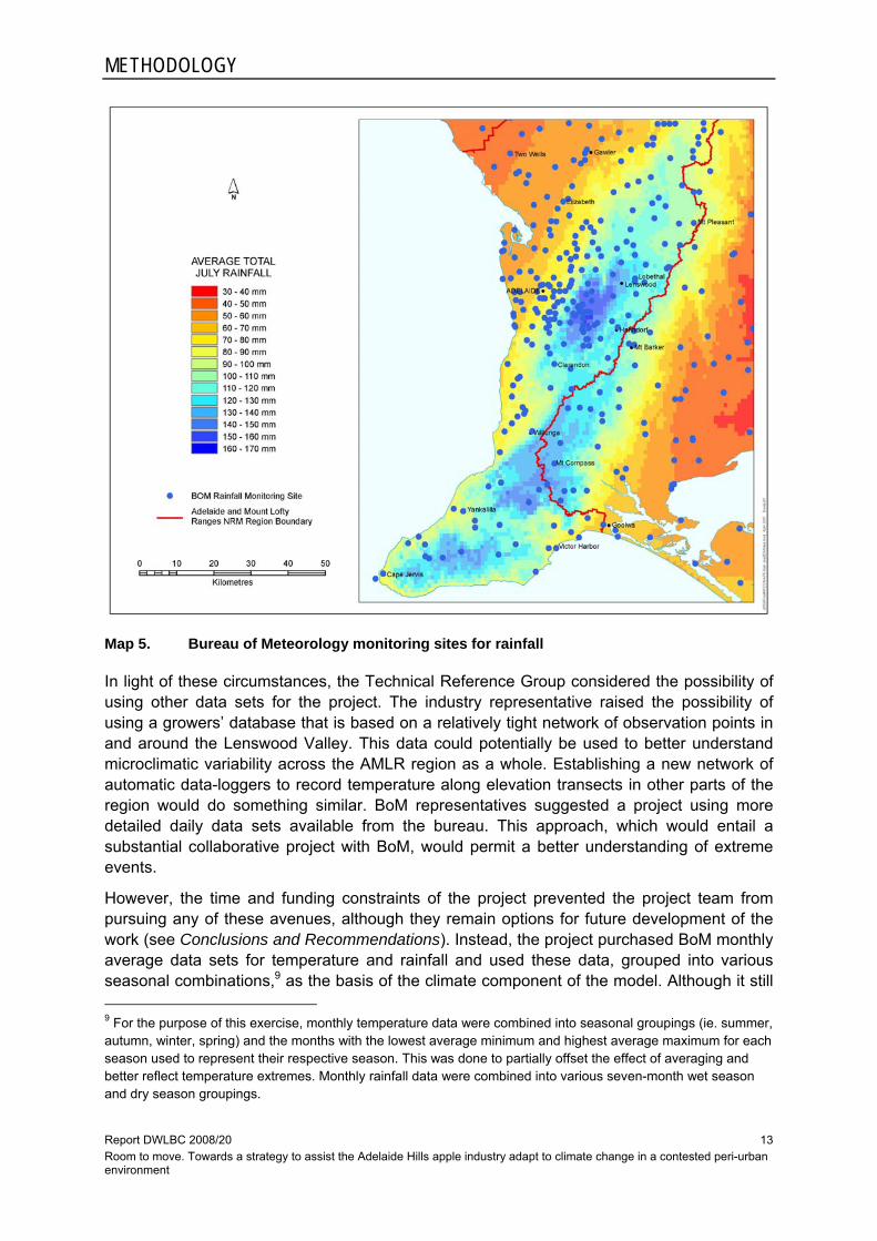
Investigations following the first Technical Reference Group meeting revealed that current climate data8 were likely to present problems for the project. Readily available temperature and rainfall data were limited to average annual and seasonal records. Concern was expressed that such generalised data mask extreme events, which are critical to understanding the success or failure of apple production. There were also serious doubts over the spatial validity of modelling behind some of the resultant mapping, especially the extent to which it accurately reflects microclimate. In the context of this study, inability to understand microclimatic variation between weather observation points is problematic. The ‘blind-spots’ that potentially result from interpolation between limited observation points could easily encompass whole properties, perhaps even whole valleys.
Maps 4 and 5 show the monitoring sites used to produce maps of temperature and rainfall respectively. The limited number of sites is especially problematic for temperature but parts of the study area also have limited coverage for rainfall. It should be noted that converting the original gridded data sets shown here, to isoline mapping, as used elsewhere in this report, does not render the data any more spatially accurate. All of the temperature and rainfall mapping in this report should be regarded as indicative rather than an accurate representation of reality.
Map 4. Bureau of Meteorology monitoring sites for temperature
8 The project did not attempt to use climate change projections because even the most recent (Suppiah et al. 2006) are at a scale that is unsuitable for a meaningful regional-scale assessment of resource availability.
METHODOLOGY
Report DWLBC 2008/20 Room to move. Towards a strategy to assist the Adelaide Hills apple industry adapt to climate change in a contested peri-urban environment
13
Map 5. Bureau of Meteorology monitoring sites for rainfall
In light of these circumstances, the Technical Reference Group considered the possibility of using other data sets for the project. The industry representative raised the possibility of using a growers’ database that is based on a relatively tight network of observation points in and around the Lenswood Valley. This data could potentially be used to better understand microclimatic variability across the AMLR region as a whole. Establishing a new network of automatic data-loggers to record temperature along elevation transects in other parts of the region would do something similar. BoM representatives suggested a project using more detailed daily data sets available from the bureau. This approach, which would entail a substantial collaborative project with BoM, would permit a better understanding of extreme events.
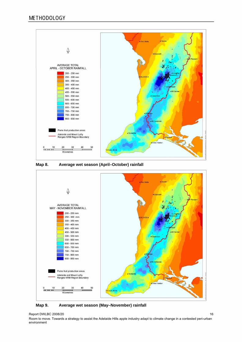
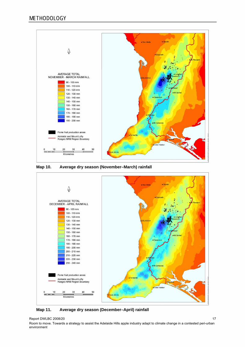
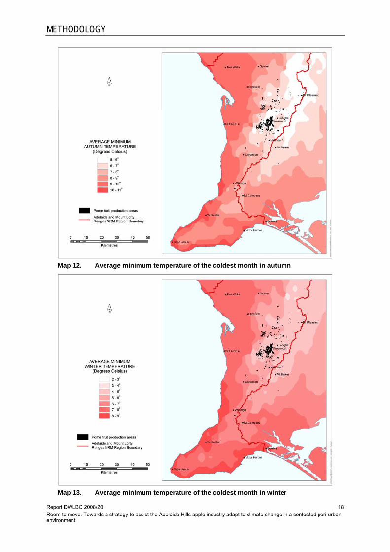
However, the time and funding constraints of the project prevented the project team from pursuing any of these avenues, although they remain options for future development of the work (see Conclusions and Recommendations). Instead, the project purchased BoM monthly average data sets for temperature and rainfall and used these data, grouped into various seasonal combinations,9 as the basis of the climate component of the model. Although it still 9 For the purpose of this exercise, monthly temperature data were combined into seasonal groupings (ie. summer, autumn, winter, spring) and the months with the lowest average minimum and highest average maximum for each season used to represent their respective season. This was done to partially offset the effect of averaging and better reflect temperature extremes. Monthly rainfall data were combined into various seven-month wet season and dry season groupings.

METHODOLOGY
Report DWLBC 2008/20 Room to move. Towards a strategy to assist the Adelaide Hills apple industry adapt to climate change in a contested peri-urban environment
14
masks extreme weather events, monthly average data provide somewhat more insight into climatic patterns than annual average data.
Work on the first two objectives commenced using the data sets listed in Table 1 below. Maps 6–17, which are derived from those data sets, appear on the following pages. These maps illustrate the relationships between various biophysical parameters and current apple growing areas. Slope, aspect and elevation data were also available to the project but not used (App. D). Slope and aspect were considered too site-specific in their impact on production to be useful in a regional-scale analysis, while elevation and slope are adequately reflected in the climatic and land capability data, which have a more direct influence on apple production anyway.
Table 1. Data sets used in GIS modelling
Parameter Criteria (source) Comment
Land capability — apples Classes 1–5
(DWLBC Soil and Land Information Group, Soil Landscapes database)
Describes soil and topography across broadly homogenous landscape units.
Some doubt over attribute rules used to define land capability for apple production.
Groundwater — salinity <1500, 1500–3000, >3000 ppm
(DWLBC Groundwater Group, Bore Records database)
This classification is not well suited to apples, which prefer <1000 ppm. Reclassification to smaller increments, eg. 250 mm, would help.
Groundwater — yield <5, >5 L/s
(DWLBC Groundwater Group, bore Records database)
Very coarse classification for planning commercial irrigated horticulture.
Rainfall — monthly average grouped into ‘wet season’ and ‘dry season’
Various user-defined mm increments
(BoM)
Temperature — monthly average minimum grouped into seasons
Various user-defined °C increments
(BoM)
Temperature — monthly average maximumgrouped into seasons
Various user-defined °C increments
(BoM)
No detail about extreme events.
Modelling is based on interpolation from a small number of observation points (esp. temperature).

METHODOLOGY
Report DWLBC 2008/20 Room to move. Towards a strategy to assist the Adelaide Hills apple industry adapt to climate change in a contested peri-urban environment
15
Map 6. Land capability classes for apples
Map 7. Groundwater salinity and yield
METHODOLOGY
Report DWLBC 2008/20 Room to move. Towards a strategy to assist the Adelaide Hills apple industry adapt to climate change in a contested peri-urban environment
16
Map 8. Average wet season (April–October) rainfall
Map 9. Average wet season (May–November) rainfall
METHODOLOGY
Report DWLBC 2008/20 Room to move. Towards a strategy to assist the Adelaide Hills apple industry adapt to climate change in a contested peri-urban environment
17
Map 10. Average dry season (November–March) rainfall
Map 11. Average dry season (December–April) rainfall
METHODOLOGY
Report DWLBC 2008/20 Room to move. Towards a strategy to assist the Adelaide Hills apple industry adapt to climate change in a contested peri-urban environment
18
Map 12. Average minimum temperature of the coldest month in autumn
Map 13. Average minimum temperature of the coldest month in winter

METHODOLOGY
Report DWLBC 2008/20 Room to move. Towards a strategy to assist the Adelaide Hills apple industry adapt to climate change in a contested peri-urban environment
19
Map 14. Average minimum temperature of the coldest month in spring
Map 15. Average maximum temperature of the warmest month in spring

METHODOLOGY
Report DWLBC 2008/20 Room to move. Towards a strategy to assist the Adelaide Hills apple industry adapt to climate change in a contested peri-urban environment
20
Map 16. Average maximum temperature of the warmest month in summer
Map 17. Average maximum temperature of the warmest month in autumn

METHODOLOGY
Report DWLBC 2008/20 Room to move. Towards a strategy to assist the Adelaide Hills apple industry adapt to climate change in a contested peri-urban environment
21
3.2 SUMMARY OF METHODOLOGY Objective 1: To form a better understanding of current resource availability for apple production in the AMLR region and, related to this, the extent to which high quality apple production is climatically ‘elastic’.
The first part of this objective required identification of a bioclimatic envelope with conditions the same as the Lenswood Valley. This is similar to a ‘homoclime’ exercise (Peter Hayman [SARDI], pers. comm., [20 December 2006]). but with reference to the physical as well as climatic factors that influence crop production potential. By using existing orchards10 as an indicator or benchmark it was possible, by simple extrapolation, to identify other parts of the AMLR region with bioclimatic conditions suitable for high quality apple production.
Each of the maps derived from the parameters listed in Table 1 were examined by the project team to find the particular criterion that most closely coincided with current apple production around Lenswood. Map 18 below illustrates this in relation to the soils parameter: comparison of land capability classes with existing orchards, shown in black on all the maps, suggests a strong correlation with class 1 and 2 land. This same process was undertaken with all other parameters. The criteria determined by that process were as follows:
• Soils Class 1 or 2
• Groundwater salinity <1500 ppm
• Groundwater yield any yield
• Average ‘winter’ (April-October) rainfall >600 mm
• Average minimum autumn temperature <8°C
• Average minimum winter temperature <6°C
• Average minimum spring temperature <7°C
• Average maximum spring temperature <24°C
• Average maximum summer temperature <29°C
• Average maximum autumn temperature <26°C
Map 19 shows the areas identified as suitable for high quality apple production on this basis11. The second part of this objective called for an expert assessment about whether or not the selected criteria accurately reflect the true bioclimatic limits of high quality apple production. If high quality apple production is more ‘elastic’ than these criteria (and the current extent of orchards in the Lenswood district) suggest, then the initial assessment of resource availability will be an understatement. This task has not been undertaken to date and should be a priority in any further development of the project. 10 Current pome fruit production areas were identified from land use mapping conducted by the EPA in 2002. Although that mapping only covers the Mount Lofty Ranges watershed area, it shows the vast bulk of apple production in the AMLR region and, as such, was sufficient for this exercise. 11 Note that average minimum spring temperature might have been expressed as <7°C but >x°C, to address frost susceptibility as well as chilling requirements. However, that refinement was not possible in this instance because of limitations in the temperature modelling and the likelihood that temperatures associated with frost events would be lost in an average monthly data figure.

METHODOLOGY
Report DWLBC 2008/20 Room to move. Towards a strategy to assist the Adelaide Hills apple industry adapt to climate change in a contested peri-urban environment
22
Map 18. Pome fruit production areas and land capability classes 1 and 2 for apples
Map 19. Current resource availability for high quality apple production using
selected criteria

METHODOLOGY
Report DWLBC 2008/20 Room to move. Towards a strategy to assist the Adelaide Hills apple industry adapt to climate change in a contested peri-urban environment
23
Objective 2: To form a better understanding of possible future resource availability scenarios under projected climate change.
Future resource availability was simulated using the same data sets and method as above, but with two key premises underpinning the analysis. The first premise was that anticipated warming will, as a rule of thumb, cause Australian climate patterns to shift ‘south and uphill’ (Peter Hayman [SARDI], pers. comm., [20 December 2006]). The second was that the strong correlation between climate and elevation in the Adelaide Hills will hold under future climate conditions and allow this rule of thumb, or at least that part of it related to elevation, to be interpreted literally. In other words, the project hypothesised that the future bioclimatic envelope for high quality apple production in the AMLR region will shrink uphill in a manner that can be inferred from current climate and natural resource data.
In this exercise, the criteria for physical factors were left unchanged, with the exception of a requirement for a minimum groundwater yield in anticipation of an increased need for supplementary water. Temperature criteria were adjusted to simulate a warming of 1°C by 2030, which is a commonly-used scenario for adaptation planning and broadly consistent with the most recent projections for South Australia (Suppiah et al. 2006). Specifically, criteria for minima over autumn, winter and spring, and for maxima over spring, summer and autumn, were set 1°C lower (ie. cooler temperatures according to current data) to indicate the likely future location of the criteria used in Map 19 under anticipated warming. The rainfall criterion was increased for the same reason but on a more arbitrary basis given the greater uncertainty over future rainfall patterns. The modified criteria for this part of the project were as follows: • Soils Class 1 or 2
• Groundwater salinity <1500 ppm
• Groundwater yield >5L/s
• Average ‘winter’ (April-October) rainfall >650 mm (+50mm)
• Average minimum autumn temperature <7°C (-1°C)
• Average minimum winter temperature <5°C (-1°C)
• Average minimum spring temperature <6°C (-1°C)
• Average maximum spring temperature <22°C (-1°C)
• Average maximum summer temperature <27°C (-1°C)
• Average maximum autumn temperature <24°C (-1°C)
Map 20 shows the areas identified as suitable for high quality apple production on this basis. Map 21 compares the current (Map 19) and future (Map 20) resource availability assessments and illustrates how the rule changes shown above shrink the area available for apple production. Note that Map 20 introduces no new areas suitable for apple production: it is a sub-set of the area shown on Map 19. Areas shown in blue on Map 21 are notionally ’lost’ as a result of the modelled climate change scenario.

METHODOLOGY
Report DWLBC 2008/20 Room to move. Towards a strategy to assist the Adelaide Hills apple industry adapt to climate change in a contested peri-urban environment
24
Map 20. Future resource availability for high quality apple production using selected
criteria
Map 21. Comparison of current and future resource availability for high quality apple
production

METHODOLOGY
Report DWLBC 2008/20 Room to move. Towards a strategy to assist the Adelaide Hills apple industry adapt to climate change in a contested peri-urban environment
25
Objective 3: To examine the manner in which development pressures in the AMLR region may interact with and amplify the impact of climate change on resource availability for apple production.
The preceding assessments of current and future resource availability were generated without reference to factors that have already alienated land suitable for apple production. To show the impact of urban areas, public land, major infrastructure and zoning of rural land for non-farm purposes (eg. rural living zones, landscape zones and special purpose zones), an exclusion layer was added to the model. This identified what are essentially no-go areas for primary production due to past development and government commitments to other land use priorities. Map 22 shows this exclusion layer along with existing orchards.
An exclusion layer is an important part of understanding resource availability in the AMLR region and begins to shift this exercise out of the theoretical and into real life. However, it provides only a static perspective on development pressure and fails to capture the major driver of change in peri-urban settings such as this. The real threat to primary production in the AMLR region is from ad hoc residential development scattered across the rural parts of the landscape. This form of development typically has negative impacts on agriculture at the level of: • agricultural operations (as a result of land-use conflict)
• farm-level investment (as a result of escalating land prices)
• the local agricultural economy (as a result of fragmentation and disintegration which leads to loss of service industries and input suppliers, reduced viability of infrastructure, closure of local processing plants, etc.).
To understand the likely effect of ad hoc rural residential development on current and future resource availability in the AMLR region, the project made reference to a recent analysis of rural dwelling construction in Adelaide’s peri-urban region (Houston & Baldock 2008). Map 3 in the Introduction shows the 30% increase in rural dwellings that occurred across Adelaide’s peri-urban region between 1985 and 200512. That analysis demonstrates graphically how rural land has been, and continues to be fragmented, over and above the changes illustrated in the exclusion layer.
To incorporate the impact of rural residential development into the resource availability assessments, a further data layer was added to the model. Map 23 shows land parcels unavailable for future primary production, including apple production, due to the presence of rural residential development. Importantly, this map only illustrates where such development will directly preclude the development of orchards. It does not show how land use conflict, escalating land prices and fragmentation will indirectly affect options for apple production. 12 That analysis demonstrates graphically how rural land has been, and continues to be fragmented, over and above the changes illustrated in the exclusion layer.

METHODOLOGY
Report DWLBC 2008/20 Room to move. Towards a strategy to assist the Adelaide Hills apple industry adapt to climate change in a contested peri-urban environment
26
Map 22. Current and future resource availability modified by excluded areas and
existing orchards
Map 23. Land unavailable for future apple production due to rural residential
development (Source: AMLR NRM land use mapping, 2008)

Report DWLBC 2008/20 Room to move. Towards a strategy to assist the Adelaide Hills apple industry adapt to climate change in a contested peri-urban environment
27
4. RESULTS
This project has revealed some significant issues with the data and information systems necessary for understanding future resource availability for apple production in the AMLR region. Significantly, those shortcomings are not so much with climate projections, which despite their limitations are nevertheless the subject of considerable investment by governments. Rather, they relate to the most basic data sets that describe current climatic and natural resource conditions for primary production. These data sets are essential for industries and sectors wanting to understand the context and starting point for their consideration of climate change adaptation strategies.
This topic is taken up in more detail below but is mentioned here because of the way these shortcomings have affected the project and its output to this stage. All of the preceding maps and their accompanying analysis need to be qualified because of limitations in the data or its classification. Similarly, the modelling process was based on various premises and assumptions that need to be clearly stated. For these reasons, it is important not to read the detail of these maps too literally. The important message is not the fate of particular parcels of land but the aggregate, regional-scale consequences for resource availability.
Subject to these qualifications and caveats, the maps presented here provide an objective and reasonable starting point for stakeholders to begin investigating resource availability for apple production under current and future climate conditions. The major outputs of the project are summarised below under their respective headings.
Objective 1: To form a better understanding of current resource availability for apple production in the AMLR region and, related to this, the extent to which high quality apple production is climatically ‘elastic’.
Map 19 shows a regional bioclimatic envelope with conditions generally similar to the Lenswood Valley. This area comprises 20 300 ha13 that are suitable, though not necessarily available, for apple production in the AMLR NRM region. Qualifications here include the following: • concerns about the spatial validity of temperature and rainfall modelling (ie. would
modelling based on a larger number of monitoring sites reveal greater microclimatic variability across the region and significantly change the assessments of resource availability?)
• concerns that this type of analysis fails to provide any insight into extreme weather events and conditions other than the average14
• minor questions about the soil attribute rules used by DWLBC to create the land capability assessment for apple production (ie. the treatment of subsoil magnesium; issues with the lower limits of class 2).
13 This figure and other calculated areas in this section are for the AMLR NRM region only. They do not include small areas shown on the maps but outside the AMLR region. 14 This raises the question as to whether the spatial pattern of extreme weather events can ever be reliably modelled for the purposes of regional strategic planning, or whether these events can only be the subject of farm-level planning and risk management.

RESULTS
Report DWLBC 2008/20 Room to move. Towards a strategy to assist the Adelaide Hills apple industry adapt to climate change in a contested peri-urban environment
28
• Questions about the coarse classification of groundwater salinity and yield, and the relevance of those classes to strategic planning for commercial horticulture (ie. would reclassification substantially reduce resource availability?).
Besides qualifications relating to data, Map 19 includes two important assumptions that underpin the extrapolation process used to identify the regional bioclimatic envelope. The first assumption is that existing production in and around the Lenswood Valley is at the limit of its climatic ‘elasticity’ and provides a good benchmark for high quality apple production. The second is that there is no significant intra-regional variability in climate attributable to either latitude or to maritime influence. Generalised assumptions such as these are not uncommon in environmental modelling but need to be clearly understood in this context.
As to the question of ‘elasticity’, the project was not able to pursue this beyond superficial consideration. If the model is to be further developed, it will be important to convene an expert panel to address this matter. The key task here would be to determine where current Lenswood Valley apple production sits relative to its theoretical bioclimatic limits. In other words, does the industry still have considerable time and ‘room to move’ in its current configuration, or is it at the ‘top of the hill’? The answer to this question is quite central to the validity of the modelling. It also has important strategic implications: if it reveals the industry still has significant ‘room to move’ in the Lenswood district, then wholesale relocation of production may not be necessary.
Objective 2: To form a better understanding of possible future resource availability scenarios under projected climate change.
Based on modified criteria that reflect anticipated warming, Map 20 shows a reduced bioclimatic envelope of 9000 ha. Here again, the map shows land that is suitable for apple production but not necessarily available.
It is important to reiterate that this part of the project did not constitute climate change modelling and the maps cannot be described as showing climate change projections. Rather, this was a simple simulation to help stakeholders understand the type of circumstances that could conceivably confront the Adelaide Hills apple industry under future climate scenarios. As suggested above, the key message here is not the particular details of the map but the scale of difference between current and future assessments and what it reveals about the broad pattern of future resource availability.
Objective 3: To examine the manner in which development pressures in the AMLR region may interact with and amplify the impact of climate change on resource availability for apple production.
After deductions to account for excluded areas and rural residential development, the assessments of current and future resource availability shrink to 13 100 ha and 4950 ha respectively, not including the 1750 ha of current production areas. Quarantining tracts of remnant native vegetation, which should presumably be treated as ‘no go’ areas, reduces these figures even further to 11 400 ha and 4200 ha respectively. Map 24 combines the two preceding assessments with these new data layers (ie. excluded areas, rural residential development and native vegetation) to illustrate current and future resource availability in the Lenswood Valley area.

RESULTS
Report DWLBC 2008/20 Room to move. Towards a strategy to assist the Adelaide Hills apple industry adapt to climate change in a contested peri-urban environment
29
Map 24. Current and future resource availability in the Adelaide Hills modified by excluded areas, rural residential development, native vegetation and existing orchards
Although it appears to leave considerable ‘room to move’ for the apple industry in the Adelaide Hills, this provisional finding should be regarded cautiously. For example, excluding areas of high water pollution sensitivity in the Mount Lofty Ranges catchment area, where apple production might conceivably be restricted, if not excluded, would modify this finding further. In addition, both assessments are still somewhat static in that they only account for existing land use and ignore trends. In reality, continuing rural residential development and ongoing competition from other primary industries, such as wine grapes and forestry, are likely to progressively narrow the apple industry’s options.
The issue of ad hoc rural residential development is especially problematic. Recent analysis of rural dwelling construction activity in the region (Houston & Baldock 2008) reveals not just the scale of recent development, but also the inability of current land use policy to restrain rural dwelling construction, despite objectives to the contrary. In other words, the trend illustrated by Map 3 is likely to continue without a significant policy change. This theme is discussed further in the following section.

Report DWLBC 2008/20 Room to move. Towards a strategy to assist the Adelaide Hills apple industry adapt to climate change in a contested peri-urban environment
30
Report DWLBC 2008/20 Room to move. Towards a strategy to assist the Adelaide Hills apple industry adapt to climate change in a contested peri-urban environment
31
5. DISCUSSION
Map 24 and those immediately preceding it enable a number of preliminary observations about future resource availability for high quality apple production in the AMLR region. Rather than examine those matters in detail here they are simply noted for consideration in due course: the task of interpreting what they mean for a climate change adaptation strategy rests with the Adelaide Hills apple industry and other regional stakeholders. Instead, three key observations are used as the basis for a wider discussion of several issues that emerged during the project.
The first observation concerns the provisional finding of a more than 50% reduction in available land within the regional bioclimatic envelope (ie. from 11 400 ha to 4200 ha) as the result of projected warming. These figures must be regarded cautiously, at least until the model has been further developed and augmented with data on other relevant factors, such as areas of high water pollution sensitivity. However, if it is assumed that those changes would have an equivalent effect on both current and future assessments, a loss on that scale is a strategically significant issue for the industry.
The likelihood of such a loss from an even smaller envelope than that calculated here underlines the need to further develop and refine the model as a matter of priority. At a minimum this should include addressing all of the issues related to data that have been raised already: ideally it would also include some more complex matters, such as the interaction between rainfall and groundwater, and the impact of the water allocation planning (WAP) process. While improving the model will not deliver definitive findings, it will enable the industry and stakeholders to make more informed decisions with a higher level of confidence.
On this point it is important to note the need for better basic data on current climatic conditions. While it might be assumed that the only data needed for adapting to climate change is that which describes anticipated changes, this project suggests something different. For industries and sectors seeking to understand the context and starting point for an adaptation strategy, especially one concerned with resource availability, current data with good coverage is essential. GIS modelling like that used here is a relatively simple, low-cost method for beginning to understand the scenarios that confront these groups, but it is only as good as the available data.
The second observation is that future resource availability seems to lie in much the same part of the AMLR region as that already occupied by the industry (see Map 21). Other parts of the AMLR region that appeared to hold some promise at the beginning of the project, such as the Fleurieu Peninsula with its low summer maximum temperatures, were not identified by the model.15 Whatever the reasons for this, it suggests a different role for land use policy to that originally envisaged. Instead of reserving new sites in remote parts of the region to enable future relocation of production areas, the challenge for planners will be to maintain the integrity of existing areas so that orchards can be progressively reconfigured. 15 The low summer maxima experienced by the Fleurieu Peninsula are offset by relatively high winter minima. This may be due to maritime influence but, equally, may be a consequence of limited temperature observation points in that part of the region failing to identify microclimatic variation.

DISCUSSION
Report DWLBC 2008/20 Room to move. Towards a strategy to assist the Adelaide Hills apple industry adapt to climate change in a contested peri-urban environment
32
This suggests the need for more attention to the issue of how resource availability is dealt with in adaptation strategies. As mentioned in the Introduction, a number of commonwealth and state government policy documents anticipate the need for relocation in response to resource availability demands but do not further explore that theme. For its part, the Garnaut Climate Change Review (2008), in its preliminary issues paper on agriculture, appears to ignore questions of resource availability in favour of in situ adaptation, whereby primary producers might end up growing different crops. Part of the answer here is to avoid the trap of thinking about responses to climate change, including issues of resource availability, in isolation from other contemporary circumstances. The importance of this point is illustrated by the phenomenon of peri-urban regions.
Peri-urban regions, especially those adjacent to the major metropolitan areas, comprise some of the fastest growing parts of Australia, due in large part to the so-called ‘sea change’ and ‘tree change’ effects (Land and Water Australia 2007). The AMLR region is no different, as illustrated by a recent analysis of rural dwelling construction activity over the past 20 years (Houston & Baldock 2008). The findings of that study show how crowded and contested the operating environment for the Adelaide Hills apple industry is becoming. They also reveal an open-ended policy approach by planning authorities that is steadily narrowing the options for all forms of primary production in the region.
Without addressing this coincidental development pressure, climate change adaptation strategies for peri-urban primary production (and for some other peri-urban sectors) risk being undermined. Regardless of whether producers relocate entirely, reconfigure locally or adapt in situ, securing future resource availability—or ensuring the continuing ability to use existing resources without impediment—seems a fundamental prerequisite for successful climate change adaptation. This will require more of land use policy than it has traditionally delivered and poses a major challenge for the South Australian planning system.
The third observation concerns the significant proportion of existing orchards that in future will fall outside the bioclimatic envelope (see Map 24). It is important that this finding not be read literally by affected growers. Even if it remains unchanged after refinements to the model, this finding essentially indicates marginal changes to the statistical probability of weather events that affect high quality apple production: it does not spell the imminent demise of apple production in those locations.
Nevertheless, this finding could provide a useful basis for prioritising adaptive action at the property level within the Adelaide Hills. Even allowing for the limitations with data and the need for refinement, the model can readily describe an adaptation gradient along which growers will have a changing array of options and timeframes for action. This might be one of the more immediately transferable outcomes of the project.16 16 It should be noted that the modelling technique used in this project is probably best suited to bioclimatic ‘islands’, like the Adelaide Hills, where there is a strong correlation between elevation and climate. NRM Boards and other parties interested in using this type of approach elsewhere should seek technical advice about its suitability for their circumstances.

Report DWLBC 2008/20 Room to move. Towards a strategy to assist the Adelaide Hills apple industry adapt to climate change in a contested peri-urban environment
33
6. CONCLUSIONS AND RECOMMENDATIONS
This project has provided important insights into the nature of current and future resource availability for high quality apple production in the AMLR region. While the findings must be qualified, and the GIS model from which those findings are derived is a work in progress that needs refinement, the project has confirmed the constrained nature of the resources available to the industry. It also provides stakeholders with an objective starting point (and a mechanism) for investigating regional-scale adaptation responses that address resource availability.
Provisional findings suggest that there is currently an area of 20 300 ha in the AMLR region with bioclimatic conditions (ie. soils, water, rainfall and temperature) broadly similar to the Lenswood Valley. Based on assumptions about how climate change will manifest itself in a small bioclimatic ‘island’ like the Adelaide Hills, the model predicts future resource availability will shrink to 9000 ha. After accounting for urban areas, public land, major infrastructure, zoning constraints, native vegetation and ad hoc rural residential development, the figures for current and future resource availability fall to 11 400 and 4200 ha respectively. Because both of these figures include the 1750 ha of current production areas, the area of potential new production sites is correspondingly smaller again.
These assessments are very probably conservative (ie. overestimates). They do not yet account for the possibility of future water quality protection policies in the Mount Lofty Ranges catchment or the indirect effects of ad hoc rural residential development. Neither do they attempt to estimate the likely consequences of continuing rural residential development across the region or competition from other primary industries, such as wine grapes and forestry. In these circumstances, the case for utilising land use policy to reserve key resources for the apple industry in the AMLR region seems compelling. However, as emphasised throughout the report, the analysis behind this conclusion would benefit from further development. Accordingly, a two-part recommendation is made.
First, it is recommended that the AMLR NRM Board note the existence of the GIS model and consider the following options for its further technical development. This work could be undertaken jointly, as a consortium of stakeholders, or independently if partners cannot be found. Because most of the data sets involved have wide application the work might also be broadened to include other industries and sectors faced with uncertainty over future resource availability.
The key areas for further attention are:
Bioclimatic factors • Investigate options for refinement of available temperature and rainfall modelling,
including:
○ use growers’ data for the Lenswood district to model microclimatic variability according to elevation/topography
○ establish networks of data loggers along selected transects throughout the region to generate new data that could be used to model microclimatic variability.

CONCLUSIONS AND RECOMMENDATIONS
Report DWLBC 2008/20 Room to move. Towards a strategy to assist the Adelaide Hills apple industry adapt to climate change in a contested peri-urban environment
34
• Investigate collaborative projects with BoM that will provide more insight into the pattern and nature of extreme weather events, including:
○ interrogate BoM daily data sets regarding the frequency/duration of extreme heat events, chill events, frost events, etc.
○ spatial modelling of frost hazard using digital elevation models. • Review/confirm the rules used to create the land capability assessment for apple
production.
• Reclassify groundwater salinity and yield data to allow for greater differentiation in the modelling.
• Investigate how the industry’s long-term outlook for access to water from all sources (ie. rainfall and groundwater combined) and the impacts of water allocation planning (WAP) can be incorporated into the model.
Other limiting factors • Add more detailed data layers relating to native vegetation and water quality sensitivity.
• Review regional land use data to identify other activities (eg. rural residential development and other competing primary industries, such as wine grapes and forestry) that may further limit resource availability.
Related to this work, but separate from the task of developing and refining data layers for the model, it will be necessary to convene an expert forum to investigate the ‘elasticity’ of high quality apple production in the AMLR region. The key task here would be to determine where current Lenswood Valley apple production sits relative to its theoretical bioclimatic limits. The answer to this question, which may need to consider varieties and market trends, will help the industry make best use of the model.
Second, it is recommended that the AMLR NRM Board note the findings relating to current and future resource availability for apple production and, notwithstanding the qualified nature of those findings, commence engagement with industry and relevant planning authorities, including Planning SA, to consider appropriate land use policy responses for reserving key resources.
Report DWLBC 2008/20 Room to move. Towards a strategy to assist the Adelaide Hills apple industry adapt to climate change in a contested peri-urban environment
35
APPENDICES
A. PROJECT MEETINGS AND PRESENTATIONS Technical Reference Group meeting #1, Prescott Building, Waite Campus, Urrbrae, 7 March 2007
Attendees: Douglas Bardsley, Jane Rowland and David Maschmedt (DWLBC); Peter Houston and Peter Willmott (PIRSA); Peter Hayman (PIRSA/SARDI); Paul James (Rural Solutions SA); Trevor Ranford (APGA of SA); Bruce Brooks and Darren Ray (BoM); Karen Hollamby (AMLR NRM Board)
Technical Reference Group meeting #2, AMLR NRM Board Offices, Eastwood, 16 June 2007
Attendees: Douglas Bardsley, Jan Rowland and David Maschmedt (DWLBC); Peter Houston and Peter Willmott (PIRSA); Peter Hayman (PIRSA/SARDI); Trevor Ranford (APGA of SA); Bruce Brooks and Darren Ray (BoM); Karen Hollamby (AMLR NRM Board);
Presentation to APGASA Inc forum, Lenswood Centre, 8 November 2007
Presentation to DWLBC, NRM and other staff, PRC Waite Campus, 6 December 2007
Attendees: Peter Houston and John Fennell (PIRSA); Susan Sweeney and David Maschmedt (DWLBC); Peter Hayman (PIRSA/SARDI); Trevor Ranford (APGA of SA); Gayle Greiger (AMLR NRM Board); Amy Williams (Rural Solutions SA)
Peer Review meeting, Level 14, 25 Grenfell St, 26 February 2008.
Attendees: Paul James and Amy Williams (Rural Solutions SA); Trevor Ranford (APGA of SA); Peter Houston (PIRSA); Jan Rowland and Susan Sweeney (DWLBC)

APPENDICES
Report DWLBC 2008/20 Room to move. Towards a strategy to assist the Adelaide Hills apple industry adapt to climate change in a contested peri-urban environment
36
B. PEER REVIEW – INDUSTRY EXPERTS Technical Peer Review Meeting 26 February 2008
Venue: PIRSA Meeting Room, Level 14, 25 Grenfell Street
Participants: Paul James and Amy Williams (Rural Solutions SA); Trevor Ranford (APGA of SA); Peter Houston (PIRSA) and Jan Rowland and Susan Sweeney (DWLBC)
Feedback Response
Given that this was a scoping study, undertaken in a limited timeframe with a limited budget, the participants were satisfied with the methodology
The report frames its findings in this context
Native vegetation is not currently excluded from the envelope of areas suitable for apple production
Native vegetation has been added to the exclusions (and also excluded from estimations of the area suitable for apple production)
Microclimatic factors may be significant This is recognised as a limitation in the report
Climate data with a daily time step is important to pick up limiting factors, particularly relating to more extreme weather conditions—for example, frost and extreme heat Data on the frequency of extreme events could be more useful than temperature data (averages) Hail has also not been included
This is recognised as a limitation in the report Should be considered in any further work
Industry data sets may be available—particularly for future work
Basic enquiries were made regarding data relating to black spot—utilisation of this data should be considered as part of any further work
Other potentially significant factors: Water permits and licensing policies Water quality protection policies and zones ‘Right to farm’ (or peri-urban) issues relating to ‘environmental covers’ and sprays, for example
Management practices/adaptations17
These are mentioned in the report but could be considered in more detail in any further work
Timing and duration of climatic conditions is only partly incorporated (eg. duration of chilling conditions)
Could be considered in more detail in any further work
Need data to show water sources less than 1000 ppm (compared with less than 1500 ppm)
This is noted in the report, but should be incorporated into any further work
Try to combine ‘access to water of an appropriate quality’ parameters into one criterion (and perhaps even include water permit and licensing policy considerations), given that growers can sometimes interchangeably use more than one source
Could be considered in more detail in any further work
Climatic requirements (or levels of vulnerability to climatic parameters/changes) may vary somewhat between varieties
Any further work should incorporate a comprehensive literature review, examining research correlating climatic parameters and yield, quality, timing factors or incidence of pests or disease (eg. including SARDI work correlating maturity date and chill hours) The methodology used in this project could be applied to specific varieties if/where significant differences in climatic requirements exist
17 Is there a pattern to their adoption? For example, does the prevalence of ‘environmental covers’ in an area tend to indicate that the area is near the edge of the bioclimatic range for apples?

APPENDICES
Report DWLBC 2008/20 Room to move. Towards a strategy to assist the Adelaide Hills apple industry adapt to climate change in a contested peri-urban environment
37
Feedback Response
The critical mass for the industry is not known – would 1500 or 1200 ha allow the industry to remain viable? (This is likely to depend partly on yield rates per hectare)
This could potentially be examined further to inform planning strategies—eg. What are the critical factors for retaining the industry in the region? What are the critical levels for industry service providers?
Key growers (with appropriate knowledge) could have been included in the Technical Reference Group (from the start)
Implement for any further work (that utilises a Technical Reference Group)
Project findings should be communicated to: the AMLR NRM Board, PIRSA, Planning SA, DWLBC, EPA, SA Water, DEH, SARDI—possibly also CSIRO, universities
Noted
Specific comments related to: page 15 (4th dot point—change summer to autumn, 6th dot point—relates to excessively high levels of magnesium in the soil); page 44 (5th dot point at top—should be DEW point, 6th dot point—should be STANTHORPE); page 45 (dot point, second to bottom on page—another reference that should refer to excessively high magnesium levels in sub soil); page 27 (note to explain change in threshold, rather than change in data set—ie. why the temperature parameters are decreased, rather than increased)
NB: The page numbering has changed since the abovementioned draft.
Changes made accordingly

APPENDICES
Report DWLBC 2008/20 Room to move. Towards a strategy to assist the Adelaide Hills apple industry adapt to climate change in a contested peri-urban environment
38
C. TECHNICAL REVIEW – CLIMATE SCIENCE Peter Hayman and Uday Nidumolu SARDI Climate Applications Unit
Feedback Response
A more comprehensive literature review is required—including further examination of the climatic ‘elasticity’ of apple production, as well as methodologies used in other instances
This should be undertaken at the commencement of any further work
Daily data and/or measurements of extremes are required This is recognised as a limitation in the report and should be addressed in any further work
Correlating current production areas with the climatic envelope assumes that climate is the key determinant of the location of the current industry location/s
Agreed
NB: Advice from industry experts was also used in setting the criteria for the model
The report should be careful to set out the constraints and limitations of the data and methodology used
For example, estimates of land areas suitable for apple production (currently and under the climate change scenario) should be rounded off
Climate data describing the microclimate seems a major constraint as the SILO data base at 5 km interpolated grid may not adequately describe the climatic conditions of the undulating terrain of the AMLR with a sparse network of weather stations
Database on the land cover is from 2002—for future work an updated data set may be relevant
Comments regarding constraints and limitations have been included in the report and area estimates (for land suitable for apple production) rounded accordingly
These points should all be considered in undertaking any further work
Boolean aggregation and strict binary choice modelling is not flexible to allow for measurement error or ambiguities, especially taking into account data availability and quality constraints
Further developments could use methods such as Fuzzy sets or Analytic Hierarchy Process (AHP)
Agreed
Climate change projections
Work by CSIRO Marine and Atmospheric Research in Victoria has tailored climate change scenarios to a 5 km grid—this could be considered for further work
Some more detail on climate projections is required (eg. the rough timeframe of scenario used)
The project initially incorporated increases of 1°C to minimum temperatures and 2°C to maximum temperatures—it was suggested that this be changed to a 1°C increase for both maxima and minima
Agreed
Minor changes were made to incorporate this suggestion
Changed accordingly
For modelling frost risk, the approach taken by Tait and Zheng (2003) could be considered (where minimum temperature events are mapped from land surface temperatures at 1 km pixels derived from satellite remote sensing and downscaled to 50 m pixels using digital elevation model
Should be considered for further work

APPENDICES
Report DWLBC 2008/20 Room to move. Towards a strategy to assist the Adelaide Hills apple industry adapt to climate change in a contested peri-urban environment
39
Feedback Response
Comment regarding the definitions of land capability and land suitability (or land suitable)
The report did not use capability and suitability interchangeably
There are references to land capability (ie. DWLBC’s assessments of soil physical and chemical properties as well as landform characteristics) and references to land which is suitable for high quality apple production (ie. it is capable plus meets other requirements regarding climate and water supply)
Land which is suitable is different again to land which is available (ie. after exclusions and other inhibiting factors have been taken into account)
No change
Why not use slope data at the 1:50 000? Class 2 land excludes slopes >30%, so no need to use a separate slope layer
Further work could include investigation of the amount of Class 3 land that has a slope of less than 30%, as well as a more refined soils assessment
Introduction could be restructured under three headings—the current apple industry in the Adelaide Hills; climate change projections; peri-urban pressure and the planning process
Good suggestions and minor changes were made
However, time was not available for major re-writing of the report
For any future work, these areas can be strengthened (eg. providing a more detailed context regarding the apple industry in the Adelaide Hills—giving a greater sense of how significant the industry is on the national scale relative to Victoria and Tasmania and some sense of the threat of NZ imports and the question of fireblight)
The strength of the project is the combination of planning issues with climatic and other apple industry requirements (including soil/land capability requirements, for example), and should be highlighted
Noted and some minor changes made
Specific comments related to: page 11, para 1 (add ‘current’ before climate); page 24 (regarding climate patterns moving uphill and south/polewards); map captions
NB: The page numbering has changed since the abovementioned draft.
Changes made accordingly

APPENDICES
Report DWLBC 2008/20 Room to move. Towards a strategy to assist the Adelaide Hills apple industry adapt to climate change in a contested peri-urban environment
40
D. ADDITIONAL MAPS Some additional maps were generated for the project but not used as it was considered that other parameters were more appropriate.
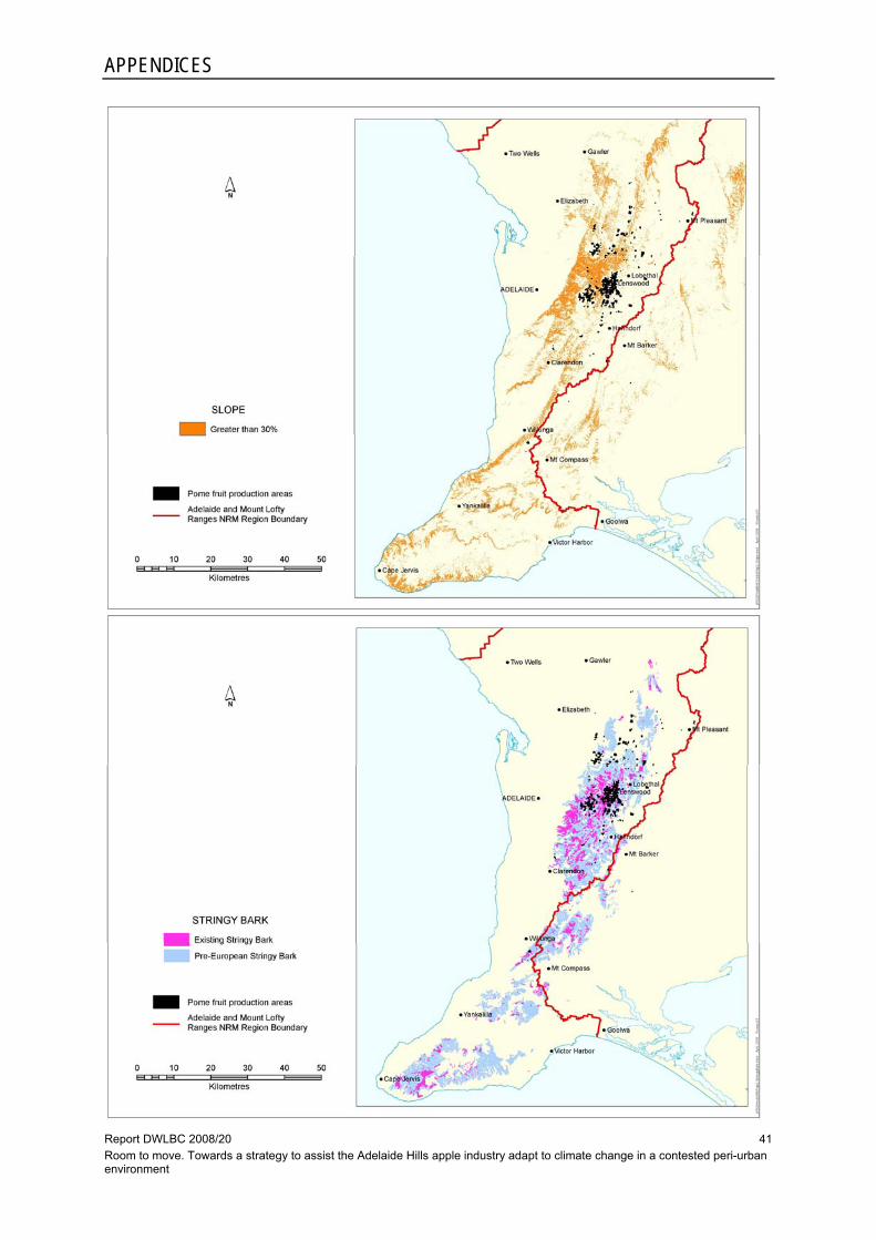
APPENDICES
Report DWLBC 2008/20 Room to move. Towards a strategy to assist the Adelaide Hills apple industry adapt to climate change in a contested peri-urban environment
41

Report DWLBC 2008/20 Room to move. Towards a strategy to assist the Adelaide Hills apple industry adapt to climate change in a contested peri-urban environment
42

Report DWLBC 2008/20 Room to move. Towards a strategy to assist the Adelaide Hills apple industry adapt to climate change in a contested peri-urban environment
43
UNITS OF MEASUREMENT
Units of measurement commonly used (SI and non-SI Australian legal) Name of unit Symbol Definition in terms of other
metric units Quantity
day d 24 h time interval
gigalitre GL 106 m3 volume
gram g 10–3 kg mass
hectare ha 104 m2 area
hour h 60 min time interval
kilogram kg base unit mass
kilolitre kL 1 m3 volume
kilometre km 103 m length
litre L 10-3 m3 volume
megalitre ML 103 m3 volume
metre m base unit length
microgram μg 10-6 g mass
microlitre μL 10-9 m3 volume
milligram mg 10-3 g mass
millilitre mL 10-6 m3 volume
millimetre mm 10-3 m length
minute min 60 s time interval
second s base unit time interval
tonne t 1000 kg mass
year y 365 or 366 days time interval
Shortened forms
°C degrees Celsius
L/s litres per second
ppm parts per million

Report DWLBC 2008/20 Room to move. Towards a strategy to assist the Adelaide Hills apple industry adapt to climate change in a contested peri-urban environment
44

Report DWLBC 2008/20 Room to move. Towards a strategy to assist the Adelaide Hills apple industry adapt to climate change in a contested peri-urban environment
45
GLOSSARY Act (the) – In this document, refers to the Natural Resources Management (SA) Act 2004, which supercedes the Water Resources (SA) Act 1997
AGO — Australian Greenhouse Office (now the Department of Climate Change, Australian Government)
AMLR — Adelaide and Mount Lofty Ranges – natural resources management region established under the Natural Resources Management Act 2004
APGA — Apple and Pear Growers Association of SA Inc
BoM — Bureau of Meteorology, Australia
Catchment — That area of land determined by topographic features within which rainfall will contribute to run-off at a particular point
DWLBC — Department of Water, Land and Biodiversity Conservation (Government of South Australia)
EPA — Environment Protection Authority (Government of South Australia)
GIS — Geographic information system; computer software linking geographic data (for example land parcels) to textual data (soil type, land value, ownership). It allows for a range of features, from simple map production to complex data analysis
Groundwater — Water occurring naturally below ground level or water pumped, diverted and released into a well for storage underground; see also ‘underground water’
Land capability — The ability of the land to accept a type and intensity of use without sustaining long-term damage
Model — A conceptual or mathematical means of understanding elements of the real world that allows for predictions of outcomes given certain conditions. Examples include estimating storm run-off, assessing the impacts of dams or predicting ecological response to environmental change
Monitoring — (1) The repeated measurement of parameters to assess the current status and changes over time of the parameters measured (2) Periodic or continuous surveillance or testing to determine the level of compliance with statutory requirements and/or pollutant levels in various media or in humans, animals, and other living things
Natural resources — Soil, water resources, geological features and landscapes, native vegetation, native animals and other native organisms, ecosystems
NRM — Natural resources management; all activities that involve the use or development of natural resources and/or that impact on the state and condition of natural resources, whether positively or negatively
NRM Board – Regional board established and charged with natural resources management under the Natural Resources Management Act 2004
Peri-urban – Peri-urban regions are those superficially rural districts within the sphere of influence of adjacent urban centres. Alternatively referred to as ‘exurban’ regions, the ‘rural-urban fringe’ or ‘the fringe’, they are generally understood to comprise the zone of transition between the edge of the newest suburbs and the outer limits of the commuter belt. See also Land and Water Australia’s (2007) peri-scoping report
PIRSA — Primary Industries and Resources South Australia (Government of South Australia)
SA — South Australia
SARDI — South Australian Research and Development Institute, a division within PIRSA
Underground water (groundwater) — Water occurring naturally below ground level or water pumped, diverted or released into a well for storage underground

GLOSSARY
Report DWLBC 2008/20 Room to move. Towards a strategy to assist the Adelaide Hills apple industry adapt to climate change in a contested peri-urban environment
46
Water allocation — (1) In respect of a water licence means the quantity of water that the licensee is entitled to take and use pursuant to the licence. (2) In respect of water taken pursuant to an authorisation under s.11 means the maximum quantity of water that can be taken and used pursuant to the authorisation
WAP — Water allocation plan: a plan prepared by a NRM Board or water resources planning committee and adopted by the Minister for Environment and Conservation in accordance with the Act

Report DWLBC 2008/20 Room to move. Towards a strategy to assist the Adelaide Hills apple industry adapt to climate change in a contested peri-urban environment
47
REFERENCES
Bardsley D, 2006, There's a change on the way — an initial integrated assessment of projected climate change impacts and adaptation options for Natural Resource Management in the Adelaide and Mount Lofty Ranges Region, Report DWLBC 2006/06, Department of Water, Land and Biodiversity Conservation, Land and Biodiversity Services Division, Adelaide
Council of Australian Governments, 2007, National climate change adaptation framework, COAG, viewed 10 April 2008, http://www.coag.gov.au/meetings/130407/docs/national_climate_change_ adaption_framework.pdf
Department of Primary Industries, 2007, ‘The climate change challenge for agriculture’, discussion paper prepared for Primary Industries Standing Committee (PISC) CEO’s Forum, 19 September 2007, Melbourne, Department of Primary Industries, Victoria
Garnaut Climate Change Review, 2008, Issues paper 1 — climate change: land use — agriculture and forestry, Garnaut Review Public Forum, viewed 10 April 2008, http://www.garnautreview.org.au/ CA25734E0016A131/WebObj/GarnautIssuesPaper1-Agricultureandforestry/$File/Garnaut%20Issues %20Paper%201%20-%20Agriculture%20and%20forestry.pdf
Houston P & Baldock P, 2008, ‘Tracking growth pressures in the outer metropolitan region: results of a study examining rural dwelling construction in Adelaide's peri-urban region 1985–2005’, internal report, Primary Industries and Resources South Australia, Agriculture, Food and Wine Division, and Spatial Information Services, Adelaide
Land and Water Australia, 2007, Peri-scoping: outcomes of an expert workshop scoping social and institutional research issues for natural resource management in peri-urban environments, Land and Water Australia, viewed 10 April 2008, http://downloads.lwa2.com/downloads/publications_pdf/ PR071250.pdf
Primary Industries and Resources South Australia, 2006, South Australian horticulture industry overview 2005–06, ScoreCard Paper 06-B4, PIRSA, Adelaide, viewed 10 April 2008, http://www.safoodcentre.com/foodtalk/files/communities/docman/141/b4horticulture industryover.pdf
Planning SA , 2007, Planning strategy for the Outer Metropolitan Adelaide Region, Planning SA, Adelaide, viewed 10 April 2008, http://www.planning.sa.gov.au/go/strategy/land-use-planning-strategy-for-sa/outer-metropolitan-adelaide-region
Planning SA, 2008, Better development planning project — planning policy library and guides, Planning SA, viewed 10 April 2008, http://www.planning.sa.gov.au/go/development-plans/better-development-plans-project/bdp-policy-library-and-guides
Suppiah R, Preston B, Whetton PH, McInnes KL, Jones RN, Macadam I, Bathols J & Kirono D, 2006, Climate change under enhanced greenhouse conditions in South Australia — an updated report on: assessment of climate change, impacts and risk management strategies relevant to South Australia, Climate Impacts and Risk Group, CSIRO Marine and Atmospheric Research, viewed 10 April 2008, http://www.greenhouse.sa.gov.au/PDFs/SA_CMAR_report_High_resolution.pdf
Sustainability and Climate Change Division, 2007, Tackling climate change: South Australia’s greenhouse strategy 2007–2020, Sustainability and Climate Change Division, Department of the Premier and Cabinet, Adelaide, viewed 10 April 2008, http://www.climatechange.sa.gov.au/PDFs/FINAL_TACKLING_CLIMATE_CHANGE_STRATEGY_ MAY_2007/TACKLING_CLIMATE_CHANGE_STRATEGY.pdf
Tait A & Zheng X, 2003, ‘Mapping frost occurrence using satellite data’, in Journal of Applied Meteorology, 42, pp. 193-203