ross environmental associates, inc
TRANSCRIPT
ROSS ENV IRONMENTAL ASSOC IATES , I NC .
Hyd r og eo l o g y , Wa t e r Qu a l i t y , G I S P l a n n i n g , R emed i a ti o n , R eg u l a t o r y
C omp l i a n c e & P e rm i t t i n g , E n v i r o nmen t a l S i t e A s s e s smen t s , P e t r o l e um
I n v e s t i g a t i o n s , Geo t h e rma l T e ch n o l o g y a n d R ad on M i t i g a t i o n
MA IN OFF I C E ° P .O . Bo x 1 533 ° S t owe , V e rmon t 0 5672 ° p h on e 8 0 2 . 2 53 . 4 280 ° f a x 8 0 2 . 2 53 . 4 258 R EG IONAL OFF I C E ° P .O . Bo x 7 86 ° Newp o r t , V e rmon t 0 5855 ° p h on e 8 0 2 . 3 34 . 9 982 ° p a g e r 8 0 2 . 2 40 . 1 151
Initial Site Investigation Report
Vermont Department of Labor
5 Green Mountain Drive
Montpelier, Vermont
SMS Site #: 2008-3878
Site Coordinates: 44o 15’ 30.05” N 72
o 35’ 24.65’’ W
7 October 2011
Prepared For:
Mr. Tom Tomasi
5 Green Mountain Drive
Montpelier, Vermont 05601-0488
Phone: (802) 828-4000
Prepared By:
Ross Environmental Associates, Inc.
P.O. Box 1533
Stowe, Vermont 05672
Phone: (802) 253-4280
Fax: (802) 253-4258
R.E.A. Project No. 28-118
R.E.A. Document #: 28118ISI
TABLE OF CONTENTS
Page
Executive Summary .................................................................................................................................. i
Site Profile .... .......................................................................................................................................... ii
1.0 Introduction ................................................................................................................................ 1
1.1 Site Location and Setting .................................................................................................... 1
1.2 Site History ......................................................................................................................... 2
1.3 Land Use and Adjacent Property Ownership ....................................................................... 2
2.0 Field Investigation Results and Procedures ........................................................................... 3
2.1 Contaminants of Concern .................................................................................................. 3
2.2 Source Area Evaluation ...................................................................................................... 3
2.3 Soil Boring and Monitoring Well Installation .................................................................... 3
2.4 Ground-Water Elevations and Flow Direction ................................................................... 5
2.5 Ground-Water Sampling and Analysis ............................................................................... 5
2.6 Investigation Procedures.......................................................................................................... 6
3.0 Sensitive Receptor Identification and Risk Assessment ......................................................... 7
3.1 Receptor Identification ....................................................................................................... 7
3.2 Risk Assessment .................................................................................................................. 7
4.0 Data Evaluation and Conceptual Model.................................................................................... 7
5.0 Recommendations ...................................................................................................................... 8
6.0 Limitations .................................................................................................................................. 8
7.0 References ................................................................................................................................... 8
List of Appendices
Appendix A Figures and Tables
Appendix B Photographs
Appendix C Soil Boring/Monitoring Well Logs
Appendix D Laboratory Reports
EXECUTIVE SUMMARY
ISI Report – VT Dept. of Labor page i
Ross Environmental Associates, Inc. 28118ISI
Ross Environmental Associates, Inc. (R.E.A.) has conducted an initial site investigation (ISI) at the
Vermont Department of Labor building, located at 5 Green Mountain Drive in Montpelier, Vermont.
Field investigation included: completion of five soil borings, the installation of four groundwater
monitoring wells, sampling and analysis of groundwater from four on-site monitoring wells, and a
receptor survey to identify potential risks to the environment and human health.
Five soil borings (SB-1, SB-2, SB-3, SB-4, and SB-5) were installed on the property to evaluate the
degree and extent of subsurface contamination that was discovered in the vicinity of a 10,000-gallon fuel-
oil underground storage tank (UST), during the tank replacement in October 2008. Soils mainly consisted
of grey clay, coarse to medium brown sand with and gravel layers. Four monitoring wells (MW-1, MW-
2, MW-3, and MW-4) were installed on the property to evaluate the degree for potential groundwater
contamination in relation to the former 10,000-gallon fuel-oil underground storage tank (UST). Available
information indicates that groundwater beneath the site has not been impacted by residual petroleum
contamination. No volatile petroleum compounds or total petroleum hydrocarbons (TPH) were detected
above laboratory method detection limits in the groundwater samples collected from the onsite
monitoring wells. Based on available information, the extent of subsurface contamination has been
adequately determined and no downgradient sensitive receptors appear to be impacted or threatened.
On the basis of the results of this investigation, R.E.A. makes the following recommendation.
1. The on-site monitoring wells should be closed in accordance with VT DEC guidelines.
2. A summary report should be completed following the closure of the monitoring wells, which
will include recommendations for Site Management Activities Completed (SMAC) status.
SITE PROFILE
ISI Report – VT Dept. of Labor page ii
Ross Environmental Associates, Inc. 28118ISI
Site Information
Site Name: Vermont Department of Labor
SMS Site #: 2008-3878
Site Address: 5 Green Mountain Drive, Montpelier, VT
Mailing Address: P.O. Box 488, Montpelier, VT 05601-0488
Telephone: (802) 828-4000
Contact/Owner: Mr. Tom Tomasi
Coordinates: latitude 44o 15’ 29.69” N, and longitude 72
o 35’ 25.77’’ W.
Contaminants of Concern: Petroleum compounds, characteristic of fuel oil.
Source: Former 10,000-gallon fuel oil UST.
Aquifer Characteristics
Soil Type: The soils at the site consisted of clay, coarse to medium sand and gravel.
Effective Porosity: 0.4
Hydraulic conductivity: 0.5 to 5.7 ft/day
Ground-water flow direction: northwest
Horizontal hydraulic gradient: 1.5 % (10/1/2011)
Average ground water velocity: 0.225 to 2.5 ft/day.
Ground-water depth bgs: 12.48 to 15.01 feet bgs.
Saturated thickness: 5.52 to 4.99 feet.
Depth to Bedrock: Refusal from 16.5 to 20 feet bgs.
Receptors
Drinking water: Drinking water for the site and the surrounding properties is provided by the
Montpelier Water System (WSID #5722)
Ground water: No volatile organic compounds or total petroleum hydrocarbons (TPH) were
detected above laboratory method detection limits in samples collected from the
monitoring wells. (Table 2, Appendix A).
Surface water: The nearest surface water feature is the Winooski River, which is located
approximately 500 feet north of the former UST.
Buildings: The property is occupied by the Vermont Department of Labor offices.
Underground utilities: The building utilizes the Montpelier municipal wastewater treatment system.
ISI Report – VT Dept. of Labor page 1
Ross Environmental Associates, Inc. 28118ISI
1.0 INTRODUCTION
On 22 August 2011, Mr. Tom Tomasi, retained the services of Ross Environmental Associates, Inc.
(R.E.A.) to complete an initial site investigation (ISI) at the property in Montpelier, Vermont in
accordance with Vermont Department of Environmental Conservation (VT DEC) guidelines. The ISI
was completed to address the presence of petroleum contamination discovered in the former location of a
10,000-gallon fuel oil underground storage tank (UST), which was removed in October 2008. This
report has been prepared by R.E.A. under the direction of Mr. Tom Tomasi, unauthorized use or
reproduction of this report is prohibited without written authorization from R.E.A., or Mr. Tomasi.
1.1 Site Location and Setting
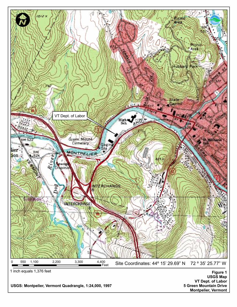
The Vermont Department of Labor (VT DOL) building is located at 5 Green Mountain Drive in
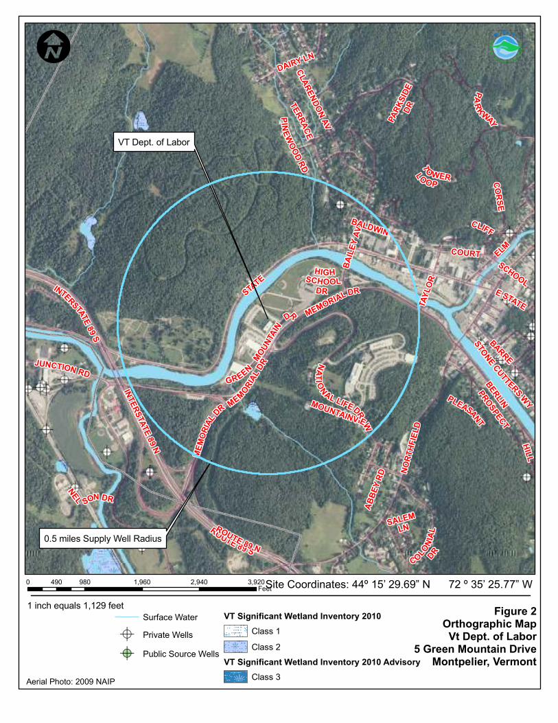
Montpelier, Vermont (Figure 1, Appendix A). The property is occupied by a state government
office, and is located in a commercial area of the Montpelier. Drinking water for the site and
surrounding properties is provided by the Montpelier Water System (WSID #5722). Based on
review of the VT Agency of Natural Resources (ANR) Private Well GIS database, is one supply well
located within a 0.5 mile radius of the release area. Wastewater disposal for the property is provided
by the Montpelier municipal wastewater system.
The ground surface of the Site slopes northward with an average elevation of approximately 530 feet
above mean sea level (Google Earth, 2011). The Winooski River is located approximately 500 feet
north and in the apparent downgradient direction from the former UST. The geographic coordinates
of the site are: latitude 44° 15’ 29.69” N, and longitude 72° 35’ 25.77” W.
The surficial geology in the vicinity of the site is mapped as a glaciolacustrine deposits consisting of
lake bottom sediments composed predominately of silt, silty clay and clay (Stewart and MacClintock,
1970). Bedrock in the area is mapped as the Missisquoi formation, Moretown member (Omm)
consisting of quartzite and quartz plagioclase granulite in layers and is of Ordovician age (Doll,
1961). No bedrock outcrops were observed on the site or adjacent properties, however, bedrock was
encountered during soil boring activities.
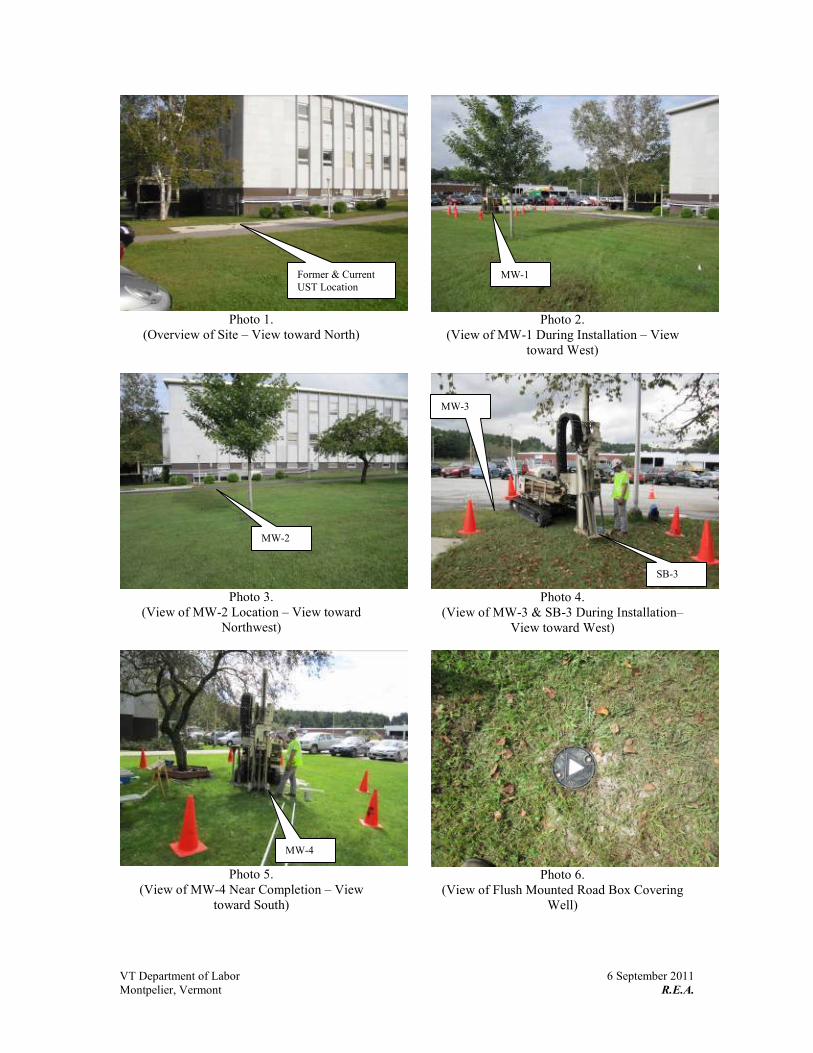
An orthophotograph showing the site and surrounding properties is included as Figure 2 (Appendix
A) and photographs of the site and surrounding area taken during the initial site investigation are
included in Appendix B.
ISI Report – VT Dept. of Labor page 2
Ross Environmental Associates, Inc. 28118ISI
1.2 Site History
On 7 October 2008, Ross Environmental Associates, Inc. (R.E.A.) provided oversight for the closure
of one 10,000-gallon fuel oil underground storage tank (UST) located at 5 Green Mountain Road in
Montpelier, Vermont. Excavation, cutting and cleaning of the UST was completed by FPH Tank
Installation and Service (FPH) of Orleans, Vermont. The age of the tank was approximately 43 years
old and was discovered to be was found to be in fair/poor condition upon removal, with some rust
and minor pitting, with observable weeps but no observable holes. A replacement 10,000-gallon
UST was installed within the open excavation. Soils in the immediate UST excavation consisted of
medium brown sand with gravel, cobbles and boulders from ground surface to approximately ten feet
below ground surface (bgs). Native soil surrounding the immediate soils consisted of grey clay from
ground surface to ten feet bgs. Additionally, organic matter with a rotting odor (presumed to be an
old wetland) was encountered at approximately 8.0 feet bgs. Groundwater was not observed in the
excavation, which extended to approximately ten feet bgs. Soils in the tank excavation were
screened for the possible presence of volatile organic compounds (VOCs) with a RAE Systems,
MiniRae 2000 photo-ionization detector (PID). PID readings on soils from the UST excavation
ranged between 0.0 to 259 parts per million per volume (ppmv), which is above the VT DEC action
level of 10 parts per million-volume (ppmv) for fuel oil contaminated soils. The highest PID
readings came from soils collected from the eastern end of the excavation below the tank at ten feet
bgs just above the concrete tank tie-down pad. The limits of soil and groundwater contamination
could not be defined during the UST closure; therefore, the VT DEC requested additional work to
identify possible impacts to the groundwater, soil, and drinking water in the vicinity of the former
UST.
To investigate the possible impacts to sensitive receptors in the vicinity of the former UST, R.E.A.
completed an Initial Site Investigation (ISI) in accordance with VT DEC guidelines. Based on this
information, R.E.A. contacted the VT DEC project manager (Mr. Ashley Desmond) and received
permission to install monitoring wells to properly characterize site conditions.
1.3 Land Use and Adjacent Property Ownership
The subject property is located at 5 Green Mountain Drive in the town of Montpelier, Vermont. The
Green Mountain Drive roadway abuts the property to the south, Montpelier High School abuts the
property to the east and a commercial property abuts the property to the west. The Winooski River
ISI Report – VT Dept. of Labor page 3
Ross Environmental Associates, Inc. 28118ISI
bounds the property to the north. An attached aerial photograph shows adjacent property site
features (Figure 2, Appendix A).
2.0 Field Investigation Results and Procedures
R.E.A.’s field investigation included: the installation of five soil borings (SB-1, SB-2, SB-3, SB-4
and SB-5) with four borings completed as groundwater monitoring wells (MW-1, MW-2, MW-3, and
MW-4); field screening of subsurface soil samples for the possible presence of volatile organic
compounds (VOCs) using a portable photo-ionization detector (PID); collection and analysis of
water samples from the four on-site monitoring wells, and a receptor survey to identify potential risks
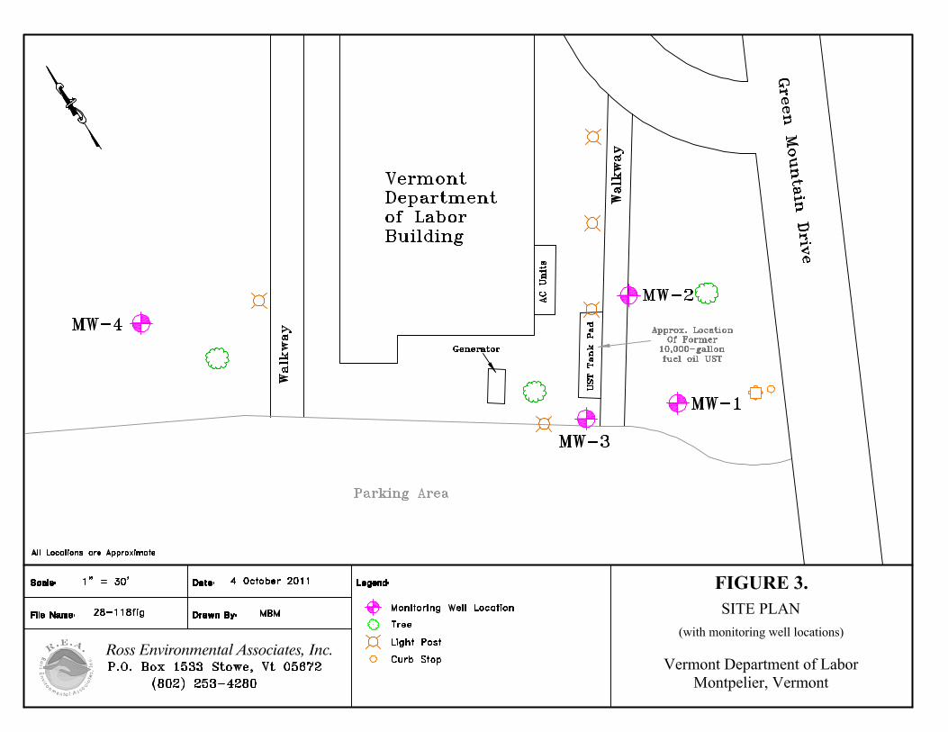
to the environment and human health. Approximate monitoring well/soil boring locations and
significant site features are shown on Figure 3 (Appendix A).
The objectives of this initial site investigation were to:
� Evaluate the degree and extent of petroleum contamination in soils and ground water;
� Qualitatively assess the risks to environmental and public health via relevant sensitive receptors
and potential contaminant migration pathways.
� Identify the need for further site characterization, appropriate monitoring, and/or remedial
actions based on the site conditions.
2.1 Contaminants of Concern
Based on available information, the contaminants of concern (COC) at the VT Dept. of Labor
building are petroleum compounds related to No. 2 fuel oil. A summary of various regulatory
standards and chemical properties for petroleum compounds typically associated with No. 2 fuel oil
is included on Table 1, Appendix A.
2.2 Source Area Evaluation
Based on the review of the UST closure report and information collected during the Initial Site
Investigation, the presence of the subsurface petroleum contamination discovered on-site is related to
the former UST, which was removed in October 2008. No other upgradient sources of petroleum
contamination were identified during the Initial Site Investigation.
2.3 Soil Boring and Monitoring Well Installation
On 6 September 2011, R.E.A. provided oversight during the installation of five soil borings (SB-1,
SB-2, SB-3, SB-4 and SB-5) four of which were completed as monitoring wells (SB-1/MW-1, SB-
ISI Report – VT Dept. of Labor page 4
Ross Environmental Associates, Inc. 28118ISI
2/MW-2, SB-4/MW-3, and SB-5/MW-4). MW-1 was installed approximately 30 feet southeast of
the UST pad, MW-2 was installed approximately 10 feet east of the UST pad, MW-3 was installed
approximately 5 feet to the southwest of the UST pad and MW-4 was installed approximately 170
northwest of the UST pad. Monitoring well/soil boring locations are shown on Figure 3, Appendix
A.
Subsurface soils at the site consisted primarily of clay, coarse to medium brown sand and gravel.
Groundwater was encountered at from approximately 12 to 17 feet below ground surface (bgs) at the
time of drilling. Soil boring SB-1/MW-1 and SB-2/MW-2 were advanced to 20 feet bgs, and SB-3,
SB-4/MW-3 and SB-5/MW-4 were advanced to 16.5, 19 and 18 feet bgs, respectively, where refusal
was met.
Photo-ionization detector (PID) readings on the soil samples collected from the soil borings ranged
between 0.0 to 0.1 ppmv. None of the soil samples exceed the VT DEC action level of 10 ppmv for
fuel-oil contaminated soil. PID screening results are included on the soil boring logs in Appendix C.
Each monitoring well was constructed using 1.0-inch-diameter schedule 40 polyvinyl chloride (PVC)
with flush threaded joints and 0.01-inch factory-slotted well screens. All of the monitoring wells
were completed with five-foot well screens. Solid PVC risers, extending to ground surface, were
used to complete each well. A clean sand pack was placed around the screened section of each
monitoring well extending one to two feet above the top of the screen, with a bentonite seal placed
above the sand pack. Flush-mounted road-box protective casings were installed over each
monitoring well. Each well was developed after installation by removing eight to ten standing
volumes of water using a peristaltic pump. Soil descriptions and monitoring well construction details
are included on the soil boring logs in Appendix C. Technical Drilling Services (TDS) of Sterling,
Massachusetts installed the soil borings and monitoring wells with a Geoprobe Drill under direct
supervision of R.E.A.
R.E.A.’s Scientist screened soil samples from the soil borings for the possible presence of volatile
organic compounds (VOCs) using a RAE Systems mini-RAE 2000 portable PID. The PID was
calibrated with an isobutylene standard gas to a benzene reference on the day of drilling.
After installation of the soil boring/monitoring wells, R.E.A. surveyed the locations of the
boring/wells in relation to existing site features. Each boring/well was located in azimuth to an
accuracy of ± 1.0 feet, and in elevation with an accuracy of ± 0.01 feet relative to an on-site
benchmark of 100.00 feet.
ISI Report – VT Dept. of Labor page 5
Ross Environmental Associates, Inc. 28118ISI
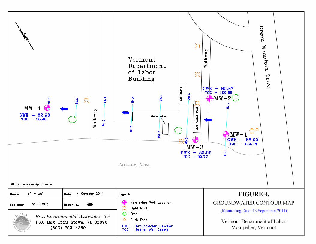
2.4 Ground Water Elevations and Flow Direction
On 13 September, ground-water flow in the unconfined surficial aquifer at the site was toward the
northwest with an estimated hydraulic gradient of approximately 1.5 percent (MW-2 to MW-4).
Water-level measurements and elevation calculations for 13 September 2011, are presented in Table
2 and the ground-water contour map prepared using this data is presented as Figure 4, Appendix A.
Static water-table elevations were computed for each monitoring well by subtracting measured depth-
to-water readings from the surveyed top-of-casing (TOC) elevations, which are relative to an
arbitrary site datum of 100.00 feet.
The effective porosity of the predominantly clayey silt encountered below the water-table is
presumably around 0.4, with hydraulic conductivities of 0.5 to 5.7 feet per day (Freeze & Cherry,
1979). Assuming Darcian flow, these estimates combine with the calculated horizontal gradient of
eight percent to yield an estimated range of ground-water flow velocities of between 0.225 to 2.5 feet
per day. Contaminant migration would be less accounting for retardation and dispersion of the
contaminants.
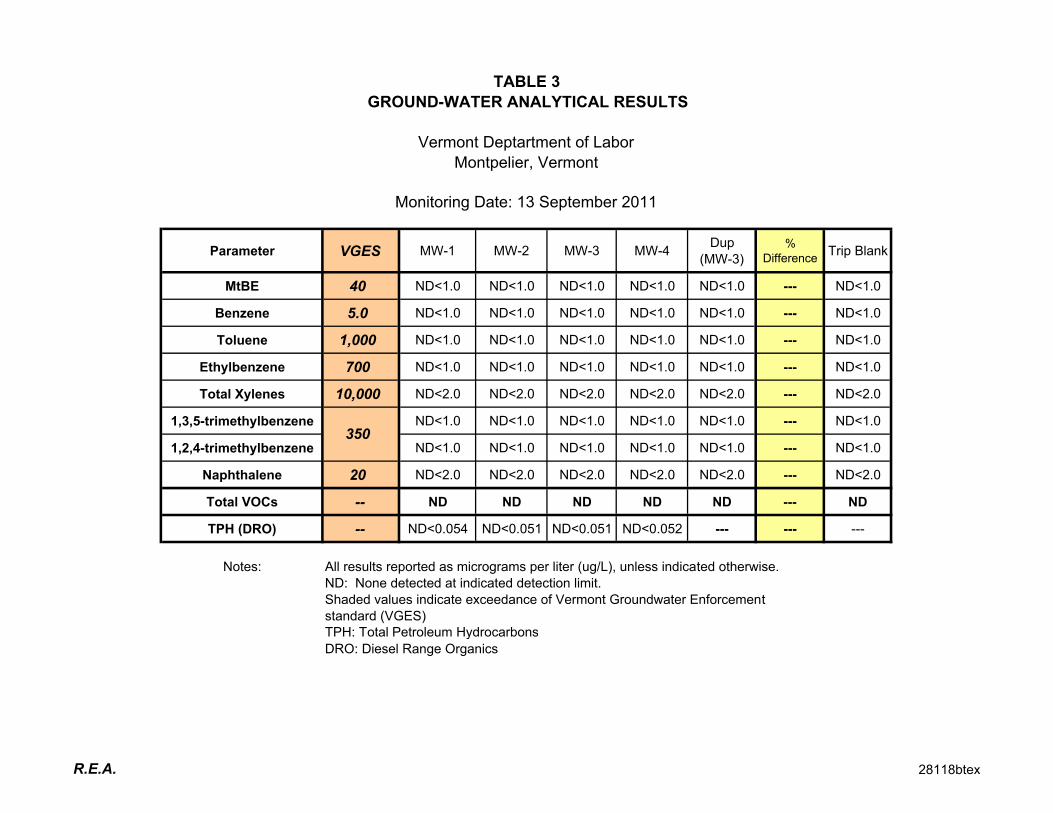
2.5 Ground Water Sampling and Analysis
Based on available information, groundwater in the immediate vicinity of the former UST system has
not been impacted by residual petroleum contamination. At this time, the extent of subsurface
petroleum contamination has been adequately defined and no off-site sensitive receptors have been
impacted or appear to be threatened by residual petroleum contamination.
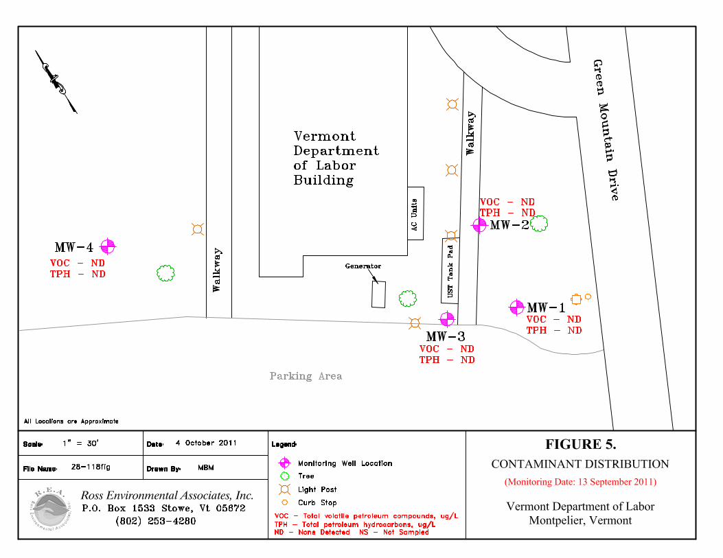
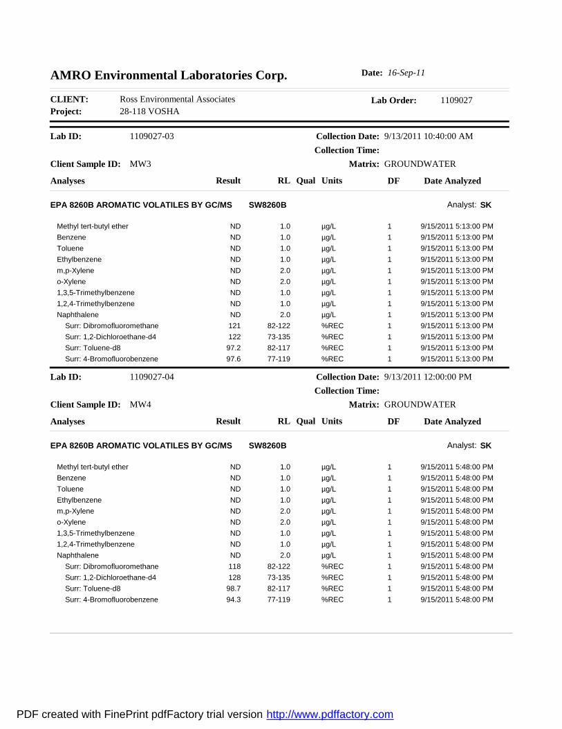
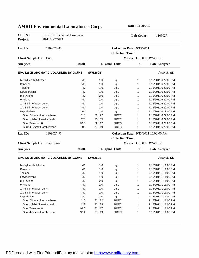
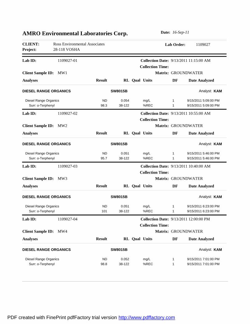
No volatile petroleum compounds or total petroleum hydrocarbons (TPH) were detected above
laboratory method detection limits in the groundwater samples collected from the four on-site
monitoring wells. No petroleum compounds were detected in the trip-blank sample, and the
duplicate sample (MW-3) was equal to the original . The analytical results are summarized on Table
3 (Appendix A), and copies of the laboratory analytical reports are included as Appendix D.
Contaminant distribution, based on samples collected on 13 September 2011, is shown on Figure 5
in Appendix A.
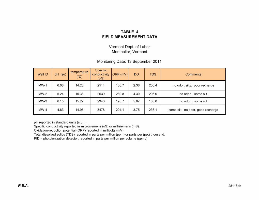
Prior to sample collection, R.E.A field personnel measured the water level in each monitoring well
and purged approximately three to five standing volumes of water from each well. All of the
ISI Report – VT Dept. of Labor page 6
Ross Environmental Associates, Inc. 28118ISI
groundwater samples were collected using dedicated polyethylene tubing. Groundwater was pumped
directly into 40-milliliter glass vials with teflon-lined septum lids. Each sample vial was preserved
with hydrochloric acid to reduce the pH to less than 2 standard units.
Immediately after sample collection, field measurements were obtained for pH, specific conductivity,
temperature, total dissolved solids (TDS), and oxygen reduction potential (ORP). A summary of the
field measurement data is included on Table 4, in Appendix A.
On 13 September 2011, groundwater samples were collected from four on-site monitoring wells
(MW-1, MW-2, MW-3, and MW-4). Groundwater samples from the monitoring wells were analyzed
for the possible presence of volatile petroleum compounds and total petroleum hydrocarbons (TPH)
in accordance with U.S. EPA Methods 8021B, and 8015 DRO (diesel-range organics), respectively.
All samples were transported under chain-of-custody in an ice-filled cooler to AMRO Environmental
Laboratories of Merrimack, New Hampshire for laboratory analysis.
2.6 Investigation Procedures
The procedures used during the initial site investigation at the Vermont Department of Labor
building are consistent with the following guidance documents:
� “Underground Storage Tank Closure and Site Assessment Requirements.” Vermont Agency
of Natural Resources, Waste Management Division. June 2003.
� “Site Investigation Guidance.” Vermont Agency of Natural Resources, Waste Management
Division. June 2005.
� “Corrective Action Guidance.” Vermont Agency of Natural Resources, Waste Management
Division. November 1997.
� “Agency Guidelines for Petroleum Contaminated Soil and Debris.” Vermont Agency of
Natural Resources, Waste Management Division. August 1996.
� ASTM D 2488-93. “Standard Practice for Description and Identification of Soils (Visual-
Manual Procedure).” American Society for Testing and Materials.
� ASTM D 5092-90. “Standard Practice for Design and Installation of Ground Water
Monitoring Wells in Aquifers.” American Society for Testing and Materials.
� ASTM D 4750-87. “Standard Test Method for Determining Subsurface Liquid Levels in a
Borehole or Monitoring Well.” American Society for Testing and Materials.
� ASTM D 4448-85a. “Standard Guide for Sampling Ground Water Monitoring Wells.”
American Society for Testing and Materials.
ISI Report – VT Dept. of Labor page 7
Ross Environmental Associates, Inc. 28118ISI
3.0 SENSITIVE RECEPTOR IDENTIFICATION AND RISK ASSESSMENT
Based on available information, the onsite supply well and underlying groundwater formation have not
been impacted and are not threatened by the use of the former UST or residual petroleum contamination.
3.1 Receptor Identification
The following sensitive receptors were identified in the vicinity of the subject property.
� Soil and groundwater within the general vicinity of the former UST.
� Drinking water wells located within 1,000 feet of the former UST.
� The Winooski River, located approximately 400 feet north of the former UST.
3.2 Risk Assessment
On the basis of the information obtained during this investigation, R.E.A. has qualitatively assessed
the risks that the subsurface contamination poses to human health and the environment. The findings
are summarized as follows:
� Based on available information, groundwater beneath the site has not been impacted by
residual petroleum contamination or the past operation of the former UST system. No
petroleum contamination was detected in the groundwater samples collected from the on-site
monitoring wells on 13 September 2011.
� Based on available information, nearby drinking water wells are not threatened or likely to
be impacted by the use of the former UST located on the Vermont Department of Labor
building. No petroleum contamination was detected in the groundwater samples collected
from the on-site monitoring wells on 13 September 2011.
� Based on the findings of the Initial Site Investigation, the Winooski River is not threatened
by the residual petroleum contamination.
4.0 DATA EVALUATION AND CONCEPTUAL MODEL
Information collected during the Initial Site Investigation indicates that petroleum contamination
discovered during the October 2008 UST closure has not impacted the underlying groundwater formation
or onsite drinking water well. Based on available information, the extent of subsurface contamination
has been adequately determined, and no downgradient or off-site sensitive receptors have been impacted.
A summary of the significant findings of the ISI is outlined below:
ISI Report – VT Dept. of Labor page 8
Ross Environmental Associates, Inc. 28118ISI
� No volatile petroleum compounds or total petroleum hydrocarbons were detected above
laboratory method detection limits in groundwater samples collected from any of the onsite
monitoring wells.
� Subsurface soils at the site consisted of clay, coarse to medium sand and gravel.
� Photo-ionization detector (PID) readings on soil samples collected from the soil borings ranged
from 0.0 to 0.1 ppmv.
� Ground-water flow in the unconfined surficial aquifer at the site was toward the northwest.
5.0 RECOMMENDATIONS
On the basis of the results of this investigation and the conclusions stated above, R.E.A. makes the
following recommendations.
1. The on-site monitoring wells should be closed in accordance with VT DEC guidelines.
2. A summary report should be completed following the closure of the monitoring wells, which will
include recommendations for Site Management Activities Completed (SMAC) status.
6.0 LIMITATIONS
This report was completed by Ross Environmental Associates, Inc. (R.E.A.) for the sole use of Mr. Tom
Tomasi in connection with an assessment of on-site environmental conditions. Use of this report by any
other person or for any other use is not authorized except with prior written consent of R.E.A. or Mr.
Tomasi.
The work was undertaken to assess environmental conditions specifically on the subject property in
accordance with generally accepted engineering and hydrogeological practices. No other warranty,
express or implied, is made. Absolute assurance that any and all possible contamination at the site was
identified cannot be provided.
The report conclusions are based, in part, on information provided by the client, their agents, or third
parties, including state or local officials. R.E.A. assumes no responsibility for the accuracy and
completeness of the information. Where visual observations are included in the report, they represent
conditions at the time of the inspection, and may not be indicative of past or future site conditions.
7.0 REFERENCES
Doll, C.G. and others, 1961. “Geologic Map of Vermont”, Office of the State Geologist.
Freeze. R. A., and Cherry, J.A., 1976. Groundwater, Prentice-Hall, Inc., Englewood Cliffs, New Jersey,
29 p.
ISI Report – VT Dept. of Labor page 9
Ross Environmental Associates, Inc. 28118ISI
Fetter, C.W., 1994. Applied Hydrogeology, 3rd Ed., Prentice Hall, Englewood Cliffs, New Jersey, 98 p.
Google Earth, 2007. “544 Moscow Road, Moscow, Vermont.”
Stewart, D.P. and MacClintock, P., 1970. “Surficial Geologic Map of Vermont”, Office of the State
Geologist.
FIGURES AND TABLES
AA
PP
PP
EE
NN
DD
II
XX
AA
I
rƒ‡¡?b››‒~ƒ‹\‡¡†Y?SS×?PT☂?QXMUX☝?m????VQ?×?RT☂?QTMVV☝?v
USGS: Montpelier, Vermont Quadrangle, 1:24,000, 1997
us?c¡fi‡M?›¢?k\‘›‒
O PKPOO QKQOO RKROO SKSOOTTOe¡¡‡
Figure 1USGS Map
VT Dept. of Labor5 Green Mountain Drive
Montpelier, Vermont
P?ƒ‹|⁄?¡fl·\“†?PKRVU?¢¡¡‡
T
OWER
L
OOP C
OR
SE
MOUNTAINVIEW
CLIFF
COLO
NIA
L D
R
BA
ILE
Y A
V
NA
TIO
N
AL LIFE DR
ROUTE 89 S
STO
NE
CU
TT
ERS
WY
GREEN
MO
UN
TAIN
D
R
JUNCTION RD
INT
ER
STA
TE
89
N
NEL
SON DR
TA
YL
OR
MEMORIAL DR
AB
BE
Y R
D
PA
RK
WAYPA
RK
SID
ED
R
STATE
ROUTE 89 N
PIN
EW
OO
D R
D
HIGH SCHOOL
DRINTE
RSTA
TE
89
S
SALEM
LN
BER
LINPLEASA
NT
ELM
HIL
L
BALDWIN
COURT
PR
OSPEC
T
ME
MO
RIA
L D
R
BARRE
NO
RT
HF
IEL
D
E STATE
MEM
OR
IAL
DR
DAIRY LN
CLA
RE
ND
ON
AV
TE
RR
AC
E
SCHOOL
I
rƒ‡¡?b››‒~ƒ‹\‡¡†Y?SS×?PT☂?QXMUX☝?m??????VQ?×?RT☂?QTMVV☝?v
us?c¡fi‡M?›¢?k\‘›‒
O XWO PKXUO QKXSO RKXQOSXOe¡¡‡
`¡‒ƒ\“?o⁄›‡›Y?QOOX?m`ho
Figure 2Orthographic MapVt Dept. of Labor
5 Green Mountain DriveMontpelier, Vermont
r·‒¢\|¡?v\‡¡‒
!A o‒ƒ¶\‡¡?v¡““†
!A o·‘“ƒ|?r›·‒|¡?v¡““†
VT Significant Wetland Inventory 2010
b“\††?P
b“\††?Q
VT Significant Wetland Inventory 2010 Advisory
b“\††?R
OMT?«ƒ“¡†?r·fifi“„?v¡““?q\~ƒ·†
P?ƒ‹|⁄?¡fl·\“†?PKPQX?¢¡¡‡
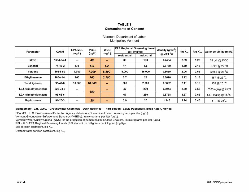
residential Industrial
MtBE 1634-04-4 --- 40 -- 39 190 0.7404 2.89 1.20 51 g/L @ 25 oC
Benzene 71-43-2 5.0 5.0 1.2 1.1 5.6 0.8789 1.69 2.13 1,820 @ 22 oC
Toluene 108-88-3 1,000 1,000 6,800 5,000 46,000 0.8669 2.06 2.65 519.5 @ 25 oC
Ethylbenzene 100-41-4 700 700 3,100 5.7 29 0.8670 2.22 3.13 187 @ 25 oC
Total Xylenes 95-47-6 10,000 10,000 -- 600 2,600 0.8802 2.11 3.13 152 @ 20 oC
1,3,5-trimethylbenzene 526-73-8 -- -- 47 200 0.8944 2.80 3.55 75.2 mg/kg @ 25oC
1,2,4-trimethylbenzene 95-63-6 -- -- 67 280 0.8758 3.57 3.65 51.9 mg/kg @ 25 oC
Naphthalene 91-20-3 -- 20 -- 3.9 20 1.145 2.74 3.40 31.7 @ 25oC
Montgomery, J.H., 2000. "Groundwater Chemicals - Desk Refrence" Third Edition. Lewis Publishers, Boca Raton, Florida.
EPA MCL. U.S. Environmental Protection Agency - Maximum Contaminant Level. In micrograms per liter (ug/L).
Vermont Groundwater Enforcement Standards (VGESs). In micrograms per liter (ug/L).
Vermont Water Quality Criteria (WQC) for the protection of human health in Class B waters. In micrograms per liter (ug/L).
RSL - U.S. EPA Regional Screening Levels (RSL) for soil. In milligrams per kilogram (mg/Kg)
Soil sorption coefficient, log Koc
Octanol/water partition coefficient, log Kow
Montpelier, Vermont
Vermont Department of Labor
Contaminants of Concern
TABLE 1
CASNParameterEPA MCL
(ug/L)
VGES
(ug/L)
350
water solubility (mg/L)
EPA Regional Screening Level-
soil (mg/kg)WQC
(ug/L)
density (g/cm3)
@ 20/4 oC
log Koc log Kow
R.E.A. 28118COCproperties
TABLE 2
GROUND WATER ELEVATION CALCULATIONS
Well I.D.Top of Casing
Elevation (ft)
Depth to
Water (ft)
Water Table
Elevation (ft)
MW-1 100.48 14.48 86.00
MW-2 100.88 15.01 85.87
MW-3 99.77 14.11 85.66
MW-4 95.46 12.48 82.98
All values reported in feet relative to arbitrary site datum of 100.00 feet
Vermont Department of Labor
Montpelier, Vermont
Monitoring Date: 13 September 2011
R.E.A. 28118gwe
Parameter VGES MW-1 MW-2 MW-3 MW-4Dup
(MW-3)
%
DifferenceTrip Blank
MtBE 40 ND<1.0 ND<1.0 ND<1.0 ND<1.0 ND<1.0 --- ND<1.0
Benzene 5.0 ND<1.0 ND<1.0 ND<1.0 ND<1.0 ND<1.0 --- ND<1.0
Toluene 1,000 ND<1.0 ND<1.0 ND<1.0 ND<1.0 ND<1.0 --- ND<1.0
Ethylbenzene 700 ND<1.0 ND<1.0 ND<1.0 ND<1.0 ND<1.0 --- ND<1.0
Total Xylenes 10,000 ND<2.0 ND<2.0 ND<2.0 ND<2.0 ND<2.0 --- ND<2.0
1,3,5-trimethylbenzene ND<1.0 ND<1.0 ND<1.0 ND<1.0 ND<1.0 --- ND<1.0
1,2,4-trimethylbenzene ND<1.0 ND<1.0 ND<1.0 ND<1.0 ND<1.0 --- ND<1.0
Naphthalene 20 ND<2.0 ND<2.0 ND<2.0 ND<2.0 ND<2.0 --- ND<2.0
Total VOCs -- ND ND ND ND ND --- ND
TPH (DRO) -- ND<0.054 ND<0.051 ND<0.051 ND<0.052 --- --- ---
Notes: All results reported as micrograms per liter (ug/L), unless indicated otherwise.
ND: None detected at indicated detection limit.
Shaded values indicate exceedance of Vermont Groundwater Enforcement
standard (VGES)
TPH: Total Petroleum Hydrocarbons
DRO: Diesel Range Organics
Monitoring Date: 13 September 2011
350
TABLE 3
GROUND-WATER ANALYTICAL RESULTS
Vermont Deptartment of Labor
Montpelier, Vermont
R.E.A. 28118btex
Well ID pH (su)temperature
(oC)
Specific
conductivity
(uS)
ORP (mV) DO TDS Comments
MW-1 6.08 14.28 2514 186.7 2.36 200.4 no odor, silty, poor recharge
MW-2 5.24 15.38 2539 280.8 4.30 206.0 no odor , some silt
MW-3 6.15 15.27 2340 195.7 5.07 188.0 no odor , some silt
MW-4 4.83 14.96 3478 204.1 3.75 236.1 some silt, no odor, good recharge
pH reported in standard units (s.u.).
Specific conductivity reported in microsiemens (uS) or millisiemens (mS).
Oxidation-reduction potential (ORP) reported in millivolts (mV).
Total dissolved solids (TDS) reported in parts per million (ppm) or parts per (ppt) thousand.
PID = photoionization detector, reported in parts per million per volume (ppmv)
Monitoring Date: 13 September 2011
TABLE 4
FIELD MEASUREMENT DATA
Vermont Dept. of Labor
Montpelier, Vermont
R.E.A. 28118ph

SITE PHOTOGRAPHS
AA
PP
PP
EE
NN
DD
II
XX
BB
VT Department of Labor 6 September 2011
Montpelier, Vermont R.E.A.
Photo 1.
(Overview of Site – View toward North)
Photo 3.
(View of MW-2 Location – View toward
Northwest)
Photo 5.
(View of MW-4 Near Completion – View
toward South)
Photo 2.
(View of MW-1 During Installation – View
toward West)
Photo 4.
(View of MW-3 & SB-3 During Installation–
View toward West)
Photo 6.
(View of Flush Mounted Road Box Covering
Well)
MW-4
MW-2
MW-1 Former & Current
UST Location
SB-3
MW-3
SOIL BORING
MONITORING WELL LOGS
AA
PP
PP
EE
NN
DD
II
XX
CC
Site Name:
Site Location:
Well Depth: 20.0' Boring Depth: 20.0' Installation Date:
6.0' Job Number:
Screen Diameter: 1" Depth: 15' REA Representative:
Screen Type/Size: Drilling Company:
Riser Diameter: 1" Depth: 5' Sampling Method:
Riser Type/Size: Reference Point (RP):
Depth (ft)Sample Depth
(ft)Recovery (%) PID (ppm) Well Profile Legend
0.0
0.1
0.1
5 0-5' 100% 0.0
0.0
10 5-10' 100% 0.0
0.0
15 10-15' 100%
0.0
0.0
20 15-20' 100% 0.0
25
AND 33-50% LITTLE 10-20% <2 VERY SOFT 8-15 STIFF 0-4 VERY LOOSE 30-50 DENSE
SOME 20-33% TRACE 0-10% 2-4 SOFT 15-30 VERY STIFF 4-10 LOOSE>50 VERY
DENSE
4-8 MEDIUM STIFF >30 HARD 10-30 MEDIUM DENSE
6-Sep-11
28-118
S. Feuer
PROPORTIONS USED NOTES:
Riser
Screen
Water Level
grey CLAY and SAND
miniRAE 2000
BLOW COUNT (COHESIVE SOILS) BLOW COUNT (GRANULAR SOILS)
Boring Terminated at 20.0' bgs.
Concrete
Native Material
ORGANICS
grey CLAY and GRAVEL
Bentonite
Filter Sand
BORING / WELL IDENTIFICATION: SB-1/MW-1
VOHSA Building
Montpelier, VT
Depth to Water (during drilling):
T.D.S.
Sample Description / Notes
0.01
0.01
GeoProbe
ROSS ENVIRONMENTAL ASSOCIATES
PHONE: (802) 253-4280 FAX: (802) 253-4258
638 Main St. Suite 1B, P.O. Box 1533
Stowe, VT 05672

Site Name:
Site Location:
Well Depth: 20.0' Boring Depth: 20.0' Installation Date:
6.0' Job Number:
Screen Diameter: 1" Depth: 15' REA Representative:
Screen Type/Size: Drilling Company:
Riser Diameter: 1" Depth: 5' Sampling Method:
Riser Type/Size: Reference Point (RP):
Depth (ft)Sample Depth
(ft)Recovery (%) PID (ppm) Well Profile Legend
0.0
0.0
0.0
5 0-5' 75% 0.0
0.0
0.0
0.0
0.0
10 5-10' 75% 0.0
0.0
0.0
15 10-15' 75%
0.0
0.0
20 15-20' 100% 0.0
25
AND 33-50% LITTLE 10-20% <2 VERY SOFT 8-15 STIFF 0-4 VERY LOOSE 30-50 DENSE
SOME 20-33% TRACE 0-10% 2-4 SOFT 15-30 VERY STIFF 4-10 LOOSE>50 VERY
DENSE
4-8 MEDIUM STIFF >30 HARD 10-30 MEDIUM DENSE
Sample Description / Notes
T.D.S. 0.01
GeoProbe
6-Sep-11
28-118Depth to Water (during drilling):
0.01
S. Feuer
BORING / WELL IDENTIFICATION: SB-2/MW-2
VOHSA Building
Montpelier, VT
PROPORTIONS USED NOTES:
Riser
Screen
Water Level
coarse medium brown SAND and CLAY
coarse medium brown SAND with Clay
miniRAE 2000
BLOW COUNT (COHESIVE SOILS) BLOW COUNT (GRANULAR SOILS)
Concrete
Native Material
Bentonite
Filter Sand
ORGANICS
Boring terminated at 20' bgs
grey CLAY with Gravel
ROSS ENVIRONMENTAL ASSOCIATES
PHONE: (802) 253-4280 FAX: (802) 253-4258
638 Main St. Suite 1B, P.O. Box 1533
Stowe, VT 05672
Site Name:
Site Location:
Well Depth: N/A Boring Depth: 9.5' Installation Date:
8.0' Job Number:
Screen Diameter: 1" Depth: 9.5' REA Representative:
Screen Type/Size: Drilling Company:
Riser Diameter: 1" Depth: 2' Sampling Method:
Riser Type/Size: Reference Point (RP):
Depth (ft)Sample Depth
(ft)Recovery (%) PID (ppm) Well Profile Legend
0.0
0.0
5 0-5' 75% 0.0
0.0
10 5-10' 75% 0.0
0.0
0.0
15 10-15' 75%
0.0
0.0
20 15-20' 25%
25
AND 33-50% LITTLE 10-20% <2 VERY SOFT 8-15 STIFF 0-4 VERY LOOSE 30-50 DENSE
SOME 20-33% TRACE 0-10% 2-4 SOFT 15-30 VERY STIFF 4-10 LOOSE>50 VERY
DENSE
4-8 MEDIUM STIFF >30 HARD 10-30 MEDIUM DENSE
miniRAE 2000
BLOW COUNT (COHESIVE SOILS) BLOW COUNT (GRANULAR SOILS)
Concrete
Native Material
Bentonite
Filter Sand
coarse medium brown SAND and CLAY
Boring Refusal at 16.5' bgs
coarse medium brown SAND and CLAY little Gravel
0.01
PROPORTIONS USED NOTES:
Riser
Screen
Water Level
T.D.S.
BORING / WELL IDENTIFICATION: SB-3
VOHSA Building
Montpelier, VT
coarse medium brown SAND and GRAVEL
6-Sep-11
28-118
0.01
ORGANICS
GeoProbe
S. Feuer
Sample Description / Notes
Depth to Water (during drilling):
ROSS ENVIRONMENTAL ASSOCIATES
PHONE: (802) 253-4280 FAX: (802) 253-4258
638 Main St. Suite 1B, P.O. Box 1533
Stowe, VT 05672

Site Name:
Site Location:
Well Depth: 20.0' Boring Depth: 20.0' Installation Date:
6.0' Job Number:
Screen Diameter: 1" Depth: 15' REA Representative:
Screen Type/Size: Drilling Company:
Riser Diameter: 1" Depth: 5' Sampling Method:
Riser Type/Size: Reference Point (RP):
Depth (ft)Sample Depth
(ft)Recovery (%) PID (ppm) Well Profile Legend
0.0
0.0
5 0-5' 75% 0.0
0.0
0.0
10 5-10' 75% 0.0
0.0
15 10-15' 75% 0.0
0.0
20 15-20' 25% 0.0
25
AND 33-50% LITTLE 10-20% <2 VERY SOFT 8-15 STIFF 0-4 VERY LOOSE 30-50 DENSE
SOME 20-33% TRACE 0-10% 2-4 SOFT 15-30 VERY STIFF 4-10 LOOSE>50 VERY
DENSE
4-8 MEDIUM STIFF >30 HARD 10-30 MEDIUM DENSE
Sample Description / Notes
S. Feuer
0.01
GeoProbe
grey CLAY
ROCK
Depth to Water (during drilling):
T.D.S.
BORING / WELL IDENTIFICATION: SB-4/MW-3
VOHSA Building
Montpelier, VT
6-Sep-11
28-118
0.01
PROPORTIONS USED NOTES:
Riser
Screen
Water Level
coarse to medium brown SAND with Gravel
miniRAE 2000
BLOW COUNT (COHESIVE SOILS) BLOW COUNT (GRANULAR SOILS)
Concrete
Native Material
Bentonite
Filter Sand
ORGANICS
Boring refusal at 19.0' bgs
ROSS ENVIRONMENTAL ASSOCIATES
PHONE: (802) 253-4280 FAX: (802) 253-4258
638 Main St. Suite 1B, P.O. Box 1533
Stowe, VT 05672
Site Name:
Site Location:
Well Depth: 20.0' Boring Depth: 20.0' Installation Date:
6.0' Job Number:
Screen Diameter: 1" Depth: 8' REA Representative:
Screen Type/Size: Drilling Company:
Riser Diameter: 1" Depth: 10' Sampling Method:
Riser Type/Size: Reference Point (RP):
Depth (ft)Sample Depth
(ft)Recovery (in) PID (ppm) Well Profile Legend
0.0
0.0
0.0
75% 0.0
5 0-5' 0.0
0.1
0.0
100%
0.0
10 5-10' 0.0
100% 0.1
15 10-15'
20 15-20'
25
AND 33-50% LITTLE 10-20% <2 VERY SOFT 8-15 STIFF 0-4 VERY LOOSE 30-50 DENSE
SOME 20-33% TRACE 0-10% 2-4 SOFT 15-30 VERY STIFF 4-10 LOOSE>50 VERY
DENSE
4-8 MEDIUM STIFF >30 HARD 10-30 MEDIUM DENSE
Sample Description / Notes
S. Feuer
Depth to Water (during drilling):
T.D.S.
BORING / WELL IDENTIFICATION: SB-5/MW-4
VOHSA Building
Montpelier, VT
6-Sep-11
28-118
0.01
0.01
GeoProbe
PROPORTIONS USED NOTES:
Riser
Screen
Water Level
medium to coarse brown SAND and GRAVEL
Boring refusal at 18.0' bgs
miniRAE 2000
BLOW COUNT (COHESIVE SOILS) BLOW COUNT (GRANULAR SOILS)
Concrete
Native Material
Bentonite
Filter Sand
ORGANICS
medium to coarse brown SAND and CLAY
ROSS ENVIRONMENTAL ASSOCIATES
PHONE: (802) 253-4280 FAX: (802) 253-4258
638 Main St. Suite 1B, P.O. Box 1533
Stowe, VT 05672
LABORATORY
ANALYTICAL REPORTS
AA
PP
PP
EE
NN
DD
II
XX
DD
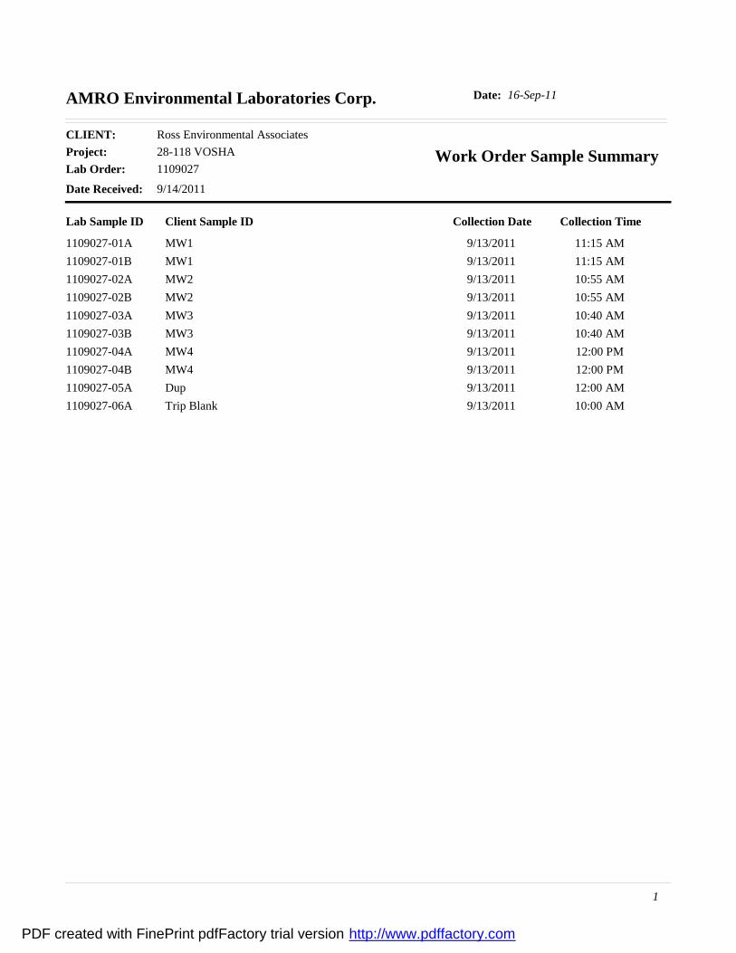
16-Sep-11Date:AMRO Environmental Laboratories Corp.
Project: 28-118 VOSHACLIENT: Ross Environmental Associates
Lab Order: 1109027Work Order Sample Summary
Date Received: 9/14/2011
Lab Sample ID Client Sample ID Collection Date Collection Time
1109027-01A MW1 9/13/2011 11:15 AM1109027-01B MW1 9/13/2011 11:15 AM1109027-02A MW2 9/13/2011 10:55 AM1109027-02B MW2 9/13/2011 10:55 AM1109027-03A MW3 9/13/2011 10:40 AM1109027-03B MW3 9/13/2011 10:40 AM1109027-04A MW4 9/13/2011 12:00 PM1109027-04B MW4 9/13/2011 12:00 PM1109027-05A Dup 9/13/2011 12:00 AM1109027-06A Trip Blank 9/13/2011 10:00 AM
1
PDF created with FinePrint pdfFactory trial version http://www.pdffactory.com
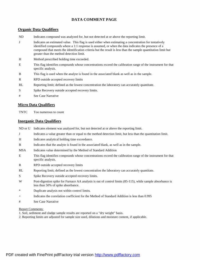
DATA COMMENT PAGE
Organic Data Qualifiers
ND Indicates compound was analyzed for, but not detected at or above the reporting limit.
J Indicates an estimated value. This flag is used either when estimating a concentration for tentatively identified compounds where a 1:1 response is assumed, or when the data indicates the presence of a compound that meets the identification criteria but the result is less than the sample quantitation limit but greater than the method detection limit.
H Method prescribed holding time exceeded.
E This flag identifies compounds whose concentrations exceed the calibration range of the instrument for that specific analysis.
B This flag is used when the analyte is found in the associated blank as well as in the sample.
R RPD outside accepted recovery limits
RL Reporting limit; defined as the lowest concentration the laboratory can accurately quantitate.
S Spike Recovery outside accepted recovery limits.
# See Case Narrative
Micro Data Qualifiers
TNTC Too numerous to count
Inorganic Data Qualifiers
ND or U Indicates element was analyzed for, but not detected at or above the reporting limit.
J Indicates a value greater than or equal to the method detection limit, but less than the quantitation limit.
H Indicates analytical holding time exceedance.
B Indicates that the analyte is found in the associated blank, as well as in the sample.
MSA Indicates value determined by the Method of Standard Addition
E This flag identifies compounds whose concentrations exceed the calibration range of the instrument for that specific analysis.
R RPD outside accepted recovery limits
RL Reporting limit; defined as the lowest concentration the laboratory can accurately quantitate.
S Spike Recovery outside accepted recovery limits.
W Post-digestion spike for Furnace AA analysis is out of control limits (85-115), while sample absorbance is less than 50% of spike absorbance.
* Duplicate analysis not within control limits.
+ Indicates the correlation coefficient for the Method of Standard Addition is less than 0.995
# See Case Narrative
Report Comments:1. Soil, sediment and sludge sample results are reported on a "dry weight" basis.2. Reporting limits are adjusted for sample size used, dilutions and moisture content, if applicable.
PDF created with FinePrint pdfFactory trial version http://www.pdffactory.com
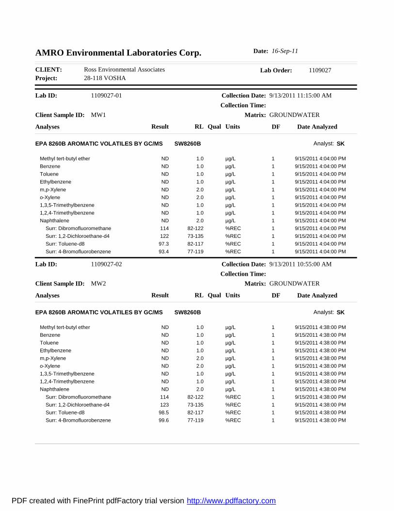
Project: 28-118 VOSHACLIENT: Ross Environmental Associates Lab Order: 1109027
AMRO Environmental Laboratories Corp. Date: 16-Sep-11
Client Sample ID: MW1
Lab ID: 1109027-01 Collection Date: 9/13/2011 11:15:00 AM
Matrix: GROUNDWATER
Analyses Result Qual Units Date AnalyzedRL DF
Collection Time:
EPA 8260B AROMATIC VOLATILES BY GC/MS SW8260B Analyst: SK
Methyl tert-butyl ether 9/15/2011 4:04:00 PM1.0 µg/L 1NDBenzene 9/15/2011 4:04:00 PM1.0 µg/L 1NDToluene 9/15/2011 4:04:00 PM1.0 µg/L 1NDEthylbenzene 9/15/2011 4:04:00 PM1.0 µg/L 1NDm,p-Xylene 9/15/2011 4:04:00 PM2.0 µg/L 1NDo-Xylene 9/15/2011 4:04:00 PM2.0 µg/L 1ND1,3,5-Trimethylbenzene 9/15/2011 4:04:00 PM1.0 µg/L 1ND1,2,4-Trimethylbenzene 9/15/2011 4:04:00 PM1.0 µg/L 1NDNaphthalene 9/15/2011 4:04:00 PM2.0 µg/L 1ND Surr: Dibromofluoromethane 9/15/2011 4:04:00 PM82-122 %REC 1114 Surr: 1,2-Dichloroethane-d4 9/15/2011 4:04:00 PM73-135 %REC 1122 Surr: Toluene-d8 9/15/2011 4:04:00 PM82-117 %REC 197.3 Surr: 4-Bromofluorobenzene 9/15/2011 4:04:00 PM77-119 %REC 193.4
Client Sample ID: MW2
Lab ID: 1109027-02 Collection Date: 9/13/2011 10:55:00 AM
Matrix: GROUNDWATER
Analyses Result Qual Units Date AnalyzedRL DF
Collection Time:
EPA 8260B AROMATIC VOLATILES BY GC/MS SW8260B Analyst: SK
Methyl tert-butyl ether 9/15/2011 4:38:00 PM1.0 µg/L 1NDBenzene 9/15/2011 4:38:00 PM1.0 µg/L 1NDToluene 9/15/2011 4:38:00 PM1.0 µg/L 1NDEthylbenzene 9/15/2011 4:38:00 PM1.0 µg/L 1NDm,p-Xylene 9/15/2011 4:38:00 PM2.0 µg/L 1NDo-Xylene 9/15/2011 4:38:00 PM2.0 µg/L 1ND1,3,5-Trimethylbenzene 9/15/2011 4:38:00 PM1.0 µg/L 1ND1,2,4-Trimethylbenzene 9/15/2011 4:38:00 PM1.0 µg/L 1NDNaphthalene 9/15/2011 4:38:00 PM2.0 µg/L 1ND Surr: Dibromofluoromethane 9/15/2011 4:38:00 PM82-122 %REC 1114 Surr: 1,2-Dichloroethane-d4 9/15/2011 4:38:00 PM73-135 %REC 1123 Surr: Toluene-d8 9/15/2011 4:38:00 PM82-117 %REC 198.5 Surr: 4-Bromofluorobenzene 9/15/2011 4:38:00 PM77-119 %REC 199.6
PDF created with FinePrint pdfFactory trial version http://www.pdffactory.com
Project: 28-118 VOSHACLIENT: Ross Environmental Associates Lab Order: 1109027
AMRO Environmental Laboratories Corp. Date: 16-Sep-11
Client Sample ID: MW3
Lab ID: 1109027-03 Collection Date: 9/13/2011 10:40:00 AM
Matrix: GROUNDWATER
Analyses Result Qual Units Date AnalyzedRL DF
Collection Time:
EPA 8260B AROMATIC VOLATILES BY GC/MS SW8260B Analyst: SK
Methyl tert-butyl ether 9/15/2011 5:13:00 PM1.0 µg/L 1NDBenzene 9/15/2011 5:13:00 PM1.0 µg/L 1NDToluene 9/15/2011 5:13:00 PM1.0 µg/L 1NDEthylbenzene 9/15/2011 5:13:00 PM1.0 µg/L 1NDm,p-Xylene 9/15/2011 5:13:00 PM2.0 µg/L 1NDo-Xylene 9/15/2011 5:13:00 PM2.0 µg/L 1ND1,3,5-Trimethylbenzene 9/15/2011 5:13:00 PM1.0 µg/L 1ND1,2,4-Trimethylbenzene 9/15/2011 5:13:00 PM1.0 µg/L 1NDNaphthalene 9/15/2011 5:13:00 PM2.0 µg/L 1ND Surr: Dibromofluoromethane 9/15/2011 5:13:00 PM82-122 %REC 1121 Surr: 1,2-Dichloroethane-d4 9/15/2011 5:13:00 PM73-135 %REC 1122 Surr: Toluene-d8 9/15/2011 5:13:00 PM82-117 %REC 197.2 Surr: 4-Bromofluorobenzene 9/15/2011 5:13:00 PM77-119 %REC 197.6
Client Sample ID: MW4
Lab ID: 1109027-04 Collection Date: 9/13/2011 12:00:00 PM
Matrix: GROUNDWATER
Analyses Result Qual Units Date AnalyzedRL DF
Collection Time:
EPA 8260B AROMATIC VOLATILES BY GC/MS SW8260B Analyst: SK
Methyl tert-butyl ether 9/15/2011 5:48:00 PM1.0 µg/L 1NDBenzene 9/15/2011 5:48:00 PM1.0 µg/L 1NDToluene 9/15/2011 5:48:00 PM1.0 µg/L 1NDEthylbenzene 9/15/2011 5:48:00 PM1.0 µg/L 1NDm,p-Xylene 9/15/2011 5:48:00 PM2.0 µg/L 1NDo-Xylene 9/15/2011 5:48:00 PM2.0 µg/L 1ND1,3,5-Trimethylbenzene 9/15/2011 5:48:00 PM1.0 µg/L 1ND1,2,4-Trimethylbenzene 9/15/2011 5:48:00 PM1.0 µg/L 1NDNaphthalene 9/15/2011 5:48:00 PM2.0 µg/L 1ND Surr: Dibromofluoromethane 9/15/2011 5:48:00 PM82-122 %REC 1118 Surr: 1,2-Dichloroethane-d4 9/15/2011 5:48:00 PM73-135 %REC 1128 Surr: Toluene-d8 9/15/2011 5:48:00 PM82-117 %REC 198.7 Surr: 4-Bromofluorobenzene 9/15/2011 5:48:00 PM77-119 %REC 194.3
PDF created with FinePrint pdfFactory trial version http://www.pdffactory.com
Project: 28-118 VOSHACLIENT: Ross Environmental Associates Lab Order: 1109027
AMRO Environmental Laboratories Corp. Date: 16-Sep-11
Client Sample ID: Dup
Lab ID: 1109027-05 Collection Date: 9/13/2011
Matrix: GROUNDWATER
Analyses Result Qual Units Date AnalyzedRL DF
Collection Time:
EPA 8260B AROMATIC VOLATILES BY GC/MS SW8260B Analyst: SK
Methyl tert-butyl ether 9/15/2011 6:22:00 PM1.0 µg/L 1NDBenzene 9/15/2011 6:22:00 PM1.0 µg/L 1NDToluene 9/15/2011 6:22:00 PM1.0 µg/L 1NDEthylbenzene 9/15/2011 6:22:00 PM1.0 µg/L 1NDm,p-Xylene 9/15/2011 6:22:00 PM2.0 µg/L 1NDo-Xylene 9/15/2011 6:22:00 PM2.0 µg/L 1ND1,3,5-Trimethylbenzene 9/15/2011 6:22:00 PM1.0 µg/L 1ND1,2,4-Trimethylbenzene 9/15/2011 6:22:00 PM1.0 µg/L 1NDNaphthalene 9/15/2011 6:22:00 PM2.0 µg/L 1ND Surr: Dibromofluoromethane 9/15/2011 6:22:00 PM82-122 %REC 1118 Surr: 1,2-Dichloroethane-d4 9/15/2011 6:22:00 PM73-135 %REC 1123 Surr: Toluene-d8 9/15/2011 6:22:00 PM82-117 %REC 198.6 Surr: 4-Bromofluorobenzene 9/15/2011 6:22:00 PM77-119 %REC 1100
Client Sample ID: Trip Blank
Lab ID: 1109027-06 Collection Date: 9/13/2011 10:00:00 AM
Matrix: GROUNDWATER
Analyses Result Qual Units Date AnalyzedRL DF
Collection Time:
EPA 8260B AROMATIC VOLATILES BY GC/MS SW8260B Analyst: SK
Methyl tert-butyl ether 9/15/2011 1:11:00 PM1.0 µg/L 1NDBenzene 9/15/2011 1:11:00 PM1.0 µg/L 1NDToluene 9/15/2011 1:11:00 PM1.0 µg/L 1NDEthylbenzene 9/15/2011 1:11:00 PM1.0 µg/L 1NDm,p-Xylene 9/15/2011 1:11:00 PM2.0 µg/L 1NDo-Xylene 9/15/2011 1:11:00 PM2.0 µg/L 1ND1,3,5-Trimethylbenzene 9/15/2011 1:11:00 PM1.0 µg/L 1ND1,2,4-Trimethylbenzene 9/15/2011 1:11:00 PM1.0 µg/L 1NDNaphthalene 9/15/2011 1:11:00 PM2.0 µg/L 1ND Surr: Dibromofluoromethane 9/15/2011 1:11:00 PM82-122 %REC 1115 Surr: 1,2-Dichloroethane-d4 9/15/2011 1:11:00 PM73-135 %REC 1123 Surr: Toluene-d8 9/15/2011 1:11:00 PM82-117 %REC 199.0 Surr: 4-Bromofluorobenzene 9/15/2011 1:11:00 PM77-119 %REC 197.4
PDF created with FinePrint pdfFactory trial version http://www.pdffactory.com
Project: 28-118 VOSHACLIENT: Ross Environmental Associates Lab Order: 1109027
AMRO Environmental Laboratories Corp. Date: 16-Sep-11
Client Sample ID: MW1
Lab ID: 1109027-01 Collection Date: 9/13/2011 11:15:00 AM
Matrix: GROUNDWATER
Analyses Result Qual Units Date AnalyzedRL DF
Collection Time:
DIESEL RANGE ORGANICS SW8015B Analyst: KAM
Diesel Range Organics 9/15/2011 5:09:00 PM0.054 mg/L 1ND Surr: o-Terphenyl 9/15/2011 5:09:00 PM38-122 %REC 198.3
Client Sample ID: MW2
Lab ID: 1109027-02 Collection Date: 9/13/2011 10:55:00 AM
Matrix: GROUNDWATER
Analyses Result Qual Units Date AnalyzedRL DF
Collection Time:
DIESEL RANGE ORGANICS SW8015B Analyst: KAM
Diesel Range Organics 9/15/2011 5:46:00 PM0.051 mg/L 1ND Surr: o-Terphenyl 9/15/2011 5:46:00 PM38-122 %REC 195.7
Client Sample ID: MW3
Lab ID: 1109027-03 Collection Date: 9/13/2011 10:40:00 AM
Matrix: GROUNDWATER
Analyses Result Qual Units Date AnalyzedRL DF
Collection Time:
DIESEL RANGE ORGANICS SW8015B Analyst: KAM
Diesel Range Organics 9/15/2011 6:23:00 PM0.051 mg/L 1ND Surr: o-Terphenyl 9/15/2011 6:23:00 PM38-122 %REC 1101
Client Sample ID: MW4
Lab ID: 1109027-04 Collection Date: 9/13/2011 12:00:00 PM
Matrix: GROUNDWATER
Analyses Result Qual Units Date AnalyzedRL DF
Collection Time:
DIESEL RANGE ORGANICS SW8015B Analyst: KAM
Diesel Range Organics 9/15/2011 7:01:00 PM0.052 mg/L 1ND Surr: o-Terphenyl 9/15/2011 7:01:00 PM38-122 %REC 198.8
PDF created with FinePrint pdfFactory trial version http://www.pdffactory.com