ross township feasibility study report
DESCRIPTION
Guide for developing TownshipsTRANSCRIPT

FEASIBILITY STUDY REPORT For
ROSS TOWNSHIP 1 of 2
Prepared By: Prepared For:
The Gateway Engineers, Inc. Ross Township 400 Holiday Drive 1000 Ross Municipal Drive
Pittsburgh, PA 15220 Pittsburgh, PA 15237
Project Number: C-17749-1320 Prepared By: James Thomas, E.I.T.
Reviewed By: Kurt Todd, P.E. Project Manager: Richard Minsterman, P.E.
July 2013 Version 1.0

Ross Township Feasibility Study Report Table of Contents
TOC-1
Copyright © 2013 The Gateway Engineers, Inc. July 2013
TABLE OF CONTENTS
Section Number
Description Page
Number Common Abbreviation List CA-1
Executive Summary ES-1
1.0 Introduction 1-1
1.1 Feasibility Study Objectives 1-2
1.2 Report Contents 1-4
2.0 Background 2-1
2.1 Regulatory Requirements 2-1
2.1.1 ACO/COA Requirements for Municipalities 2-1
2.1.2 Consent Decree Requirements Relating to Design Flow for Municipalities 2-2
2.2 Role of the FSWG 2-6
2.2.1 Objectives of the FSWG 2-7
2.2.2 Task List Developed by the FSWG 2-8
2.3 Municipal Coordination Overview 2-22
3.0 Existing System Description 3-1
3.1 Municipal Systems 3-1
3.1.1 Existing Sewershed Description for Ross Township 3-1
3.1.2 Multi-Municipal System(s) and Complex Sewersheds 3-3
3.1.3 Current Flow Management Agreements 3-4
3.2 Existing Overflows 3-9
3.3 Direct Stream Inflows 3-9
4.0 Sewer System Characterization 4-1
4.1 2008 Flow Monitoring Data Evaluation 4-1
4.1.1 Flow Monitoring Program Background 4-1
4.1.2 Additional Flow Monitoring 4-2
4.1.3 Flow Monitoring Results 4-2
4.2 Description of Flow Isolation Studies and Sewer System Evaluation Surveys 4-3
4.2.1 Flow Isolation Study/SSES Procedures 4-3
4.3 Recommendations Resulting from Ross Township Flow Isolation Studies/SSES 4-3
4.4 Best Management Practices – Green Technology Screening 4-4
4.5 Summary of Defect Repairs 4-6
5.0 Sewer System Capacity Analysis 5-1
5.1 Development and Calibration/Verification of H&H Tools 5-1
5.2 Baseline Conditions 5-5
5.2.1 Dry Weather Flows (Existing and Future) 5-7
5.2.2 Groundwater Infiltration (Existing and Future) 5-10
5.2.3 Estimation Process for Unmonitored Areas 5-11
5.3 Preliminary Flow Estimates 5-12
5.4 Capacity Deficient Sewers 5-13
5.4.1 Existing Basement Flooding Areas – History and Locations 5-20
5.4.2 Capacity Requirements for Various Design Storms and Levels of Protection 5-20
5.5 Overflow Frequency and Volume 5-22

Ross Township Feasibility Study Report Table of Contents
TOC-2
Copyright © 2013 The Gateway Engineers, Inc. July 2013
TABLE OF CONTENTS - CONTINUED
Section Number
Description Page
Number 6.0 CSO/SSO Control Levels 6-1
6.1 Background for Selection of Control Level 6-1
6.1.1 CSO Control Level 6-1
6.1.2 SSO Control Level 6-1
6.2 Recommendations for Control Levels 6-3
7.0 Alternative Evaluation (Internal Municipal) 7-1
7.1 Evaluation Criteria Development 7-7
7.2 Cost Estimates 7-7
7.3 Alternative Selection Process 7-10
7.4 Alternative Evaluation Results 7-10
7.5 Recommended Alternative Description 7-11
7.6 Recommended Alternative Operation and Maintenance Per POC 7-14
7.7 Stream Removals 7-14
8.0 Multi-Municipal Sewershed Recommended Alternatives 8-1
9.0 Financial and Institutional Considerations 9-1
9.1 MOU and Inter-Municipal Agreements 9-1
9.2 Funding Alternatives 9-1
9.3 User Cost Analysis 9-5
9.4 Affordability 9-6
10.0 Integration of Selected Alternatives 10-1
11.0 Implementation 11-1
11.1 Implementation Schedule 11-1
11.2 Joint Municipal Planning and Implementation 11-1
11.3 Regulatory Compliance Reporting 11-1
Appendices
Tab Number
A 3RWW FSWG Document 002A
B POC Report: A-67 (on attached CD)
C POC Report: A-68 (on attached CD)
D POC Report: O-15 (on attached CD)
E Agreement Information (on attached CD)
F Hydrographs
G PFE Results
H SPC Population Data
I Interconnections Table
J Capacity Tables (A-58 & A-60)
K Alternative Mapping
L Detailed Cost Estimates
M Schedule 6 CSO Affordability

Ross Township Feasibility Study Report Table of Contents
TOC-3
Copyright © 2013 The Gateway Engineers, Inc. July 2013
TABLE OF CONTENTS - CONTINUED
Section Number
Description Tab
Number Figures
1 Existing Sewershed Map
2 POC O-15 Map
3 POC O-18 Map
4 POC O-25 Map
5 POC O-27 Map
6 POC A-58 Map
7 POC A-60 Map
8 POC A-67 Map
9 POC A-68 Map
10 Flow Monitoring Program
11 Additional Design Meters
12 2 Year Capacity Map – POC A-68
13 10 Year Capacity Map – POC A-68
14 2 Year Capacity Map – POC O-15
15 10 Year Capacity Map – POC O-15
16 2 Year Capacity Map – POC O-18
17 10 Year Capacity Map – POC O-18
18 2 Year Capacity Map – POC O-25
19 10 Year Capacity Map – POC O-25
20 2 Year Capacity Map – POC O-27
21 10 Year Capacity Map – POC O-27
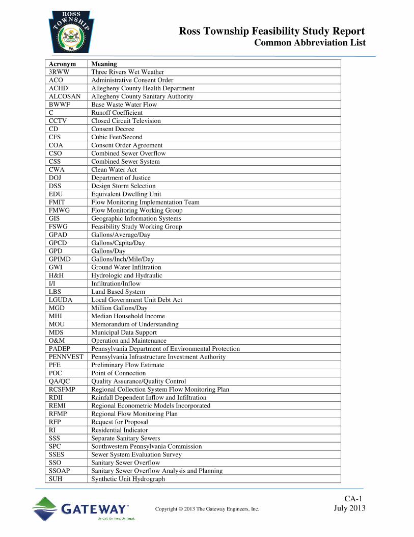
Ross Township Feasibility Study Report Common Abbreviation List
CA-1
Copyright © 2013 The Gateway Engineers, Inc. July 2013
Acronym Meaning 3RWW Three Rivers Wet Weather
ACO Administrative Consent Order
ACHD Allegheny County Health Department
ALCOSAN Allegheny County Sanitary Authority
BWWF Base Waste Water Flow
C Runoff Coefficient
CCTV Closed Circuit Television
CD Consent Decree
CFS Cubic Feet/Second
COA Consent Order Agreement
CSO Combined Sewer Overflow
CSS Combined Sewer System
CWA Clean Water Act
DOJ Department of Justice
DSS Design Storm Selection
EDU Equivalent Dwelling Unit
FMIT Flow Monitoring Implementation Team
FMWG Flow Monitoring Working Group
GIS Geographic Information Systems
FSWG Feasibility Study Working Group
GPAD Gallons/Average/Day
GPCD Gallons/Capita/Day
GPD Gallons/Day
GPIMD Gallons/Inch/Mile/Day
GWI Ground Water Infiltration
H&H Hydrologic and Hydraulic
I/I Infiltration/Inflow
LBS Land Based System
LGUDA Local Government Unit Debt Act
MGD Million Gallons/Day
MHI Median Household Income
MOU Memorandum of Understanding
MDS Municipal Data Support
O&M Operation and Maintenance
PADEP Pennsylvania Department of Environmental Protection
PENNVEST Pennsylvania Infrastructure Investment Authority
PFE Preliminary Flow Estimate
POC Point of Connection
QA/QC Quality Assurance/Quality Control
RCSFMP Regional Collection System Flow Monitoring Plan
RDII Rainfall Dependent Inflow and Infiltration
REMI Regional Econometric Models Incorporated
RFMP Regional Flow Monitoring Plan
RFP Request for Proposal
RI Residential Indicator
SSS Separate Sanitary Sewers
SPC Southwestern Pennsylvania Commission
SSES Sewer System Evaluation Survey
SSO Sanitary Sewer Overflow
SSOAP Sanitary Sewer Overflow Analysis and Planning
SUH Synthetic Unit Hydrograph

Ross Township Feasibility Study Report Common Abbreviation List
CA-2
Copyright © 2013 The Gateway Engineers, Inc. July 2013
Acronym Meaning SWMM5 Storm Water Management Model
TMDL Total Maximum Daily Load
USEPA United States Environmental Protection Agency
VRS Virtual Reference Station
WWP Wet Weather Plan

Ross Township Feasibility Study Report Executive Summary
ES-1
Copyright © 2013 The Gateway Engineers, Inc. July 2013
EXECUTIVE SUMMARY
On May 4, 2004, Ross Township (Township) entered into an Administrative Consent Order
(ACO) with the Allegheny County Health Department (ACHD) in order to eliminate sanitary
sewer overflows and comply with the Clean Streams Law. As part of this Consent Order, the
Township was required to inventory it’s system, complete necessary repairs, perform flow
monitoring, dye testing, adopt a point-of-sale dye testing ordinance, adopt an ordinance to
eliminate storm water connections, perform a hydraulic analysis of the collection system,
develop an Operation and Maintenance (O&M) Plan, and prepare a Feasibility Study to address
any collection system deficiencies to eliminate SSO’s. This report was to be submitted to the
ACHD within six (6) months after the submittal of an Allegheny County Sanitary Authority
(ALCOSAN) wet weather plan or July 31, 2013, based on the submittal date of the ALCOSAN
plan.
The Ross Township sanitary sewer system consists of all gravity sewers. The system is
interconnected with other sanitary collection systems and all treatment is provided by
ALCOSAN at the Woods Run Treatment Facility. Approximately half of the sanitary sewers in
the Township are owned by the Girty’s Run Joint Sewer Authority and flow to ALCOSAN
through the Point of Connection (POC) A-67, while the other half are owned by the Township.
The Ross Township portion of the system serves a population of approximately 16,000 residents,
utilizing approximately 94 miles of gravity sewer and 2,300 structures.
The Ross Township owned sewers are part of the following seven (7) multi-municipal
sewersheds:
• A-58, which is a sub-shed of A-51, Ross flows through the City of Pittsburgh before
connecting into the ALCOSAN system.
• A-60, Ross flows through the City of Pittsburgh before connecting into the ALCOSAN
system.

Ross Township Feasibility Study Report Executive Summary
ES-2
Copyright © 2013 The Gateway Engineers, Inc. July 2013
• A-68, Ross receives flow from the Town of McCandless and Shaler Township then the
combined flows travel through Shaler Township and Etna Borough before connecting
into the ALCOSAN system.
• O-15, Ross flows to the ALCOSAN system through the LROC interceptor that is shared
with Kilbuck Township, Ohio Township, Franklin Park Borough, the Town of
McCandless, West View Borough and Emsworth Borough.
• O-18, Ross flows through Borough of Bellevue, Avalon Borough and Ben Avon Borough
before connecting into ALCOSAN.
• O-25 is mainly made up of an area which receives flow from Borough of Bellevue before
connecting into ALCOSAN and a small section that flows into the City of Pittsburgh
before connecting into ALOCSAN.
• O-27, Ross flows through the City of Pittsburgh before connecting into the ALCOSAN
system.
Through the Feasibility Study analysis it was determined that no internal projects (projects
related to Ross Township sewers) are required in POC’s A-58, A-60, O-15 and O-27, as the
Township owned lines are already capable of conveying a 10-year design storm. The presented
alternatives for POC’s A-68, O-18 and O-25 were designed to 2- and 10- year design storm
control levels. For the A-68 sewershed, the winter storm was used in the analysis, as it had the
greatest impact on the system. For all of the remaining sewersheds the summer design storms
created the highest peak flow rates and therefore were used for analysis. During the alternative
design and cost estimation process it was found that the differences between the 2- and 10- year
level of control did not yield significant differences in projects or estimated construction costs,
therefore the Township chose the following 10-year design options as the preferred alternatives:
• A-68: The preferred alternative in POC A-68 (Alternative 1B: Parallel and Sewerline
Upsizing) includes the construction of approximately 3,300 linear feet (LF) of 10”
parallel sewer along the main municipal interceptor, from manhole (MH) #4826 to MH
#4065, the upsizing of approximately 1,600 LF of pipe ranging in size from 12” to 18”,

Ross Township Feasibility Study Report Executive Summary
ES-3
Copyright © 2013 The Gateway Engineers, Inc. July 2013
from MH #4305 to MH #4826, MH #873 to MH #339 and MH #4065 to MH #4086 and
the installation, and operation and maintenance of, a 1.557 Million-Gallons/Day (MGD)
storage tank after MH #4086. (This tank was sized to address overflows within Ross
Township as well as downstream overflows in Shaler Township). Prior to the
construction and permitting of this alternative, flow isolation and potential removal of
Infiltration/Inflow (I&I) will be completed in order to refine the sizing of the storage
tank.
• O-18: The preferred alternative in POC O-18 (Alternative 2B: Parallel and Sewerline
Upsizing) includes the upsizing of approximately 4,500 LF of pipe ranging from 8” to
24” in size along the main municipal interceptor from MH #3780 to MH #9101. Also
included is approximately 1,100 LF of parallel sewers ranging from 12” to 21” from MH
#2139 to MH #2135B.
• O-25: The preferred alternative in POC O-25 (Alternative 3A: Sewerline Upsizing)
includes the upsizing of approximately 3,400 LF of pipe ranging from 12” to 15” in size
along the main municipal interceptor from MH #1388 to MH #1218. Also included are
the removal of the diversion MH #2092 and the upsizing of approximately 300 LF of
sanitary sewer to 10” from MH#707 to MH #2092.
As per the requirements of the ACO, significant structure deficiencies within the system are
continuously repaired throughout the Township as they are identified through the Consent Order
Closed Circuit Television (CCTV) Program. Since 2004, the Township has completed
approximately 24,000 LF of sewer line repairs, encompassing new construction, pipe bursting,
excavation and cured in place pipe (CIPP) work. In addition, the Township has also completed
approximately 100 structure repairs including new and raised manholes.
In addition to the proposed internal municipal projects and the previously completed repair work,
the Township is also required to contribute to the multi-municipal projects in POC’s O-15 and
A-68. The Township is aware of twelve municipal agreements specific to individual points of
connection sewersheds within the Township and another two agreements that relate to the entire

Ross Township Feasibility Study Report Executive Summary
ES-4
Copyright © 2013 The Gateway Engineers, Inc. July 2013
Township sewer system. These agreements will assist the municipalities in determining the
shared costs of the multi-municipal projects. The following table shows the summary of Ross
Township required funding for both internal and shared multi-municipal projects.
SUMMARY OF ROSS TOWNSHIP REQUIRED FUNDING
POC Ross Township Internal
Alternative Costs Ross Township Project Multi-Municipal Alternative Costs
Total Capital Cost
A-581 $0.00 $20,000.00 $20,000.00
A-60 $0.00 $0.00 $0.00
A-67 $0.00 $17,630,000.002 $17,630,000.00
A-68 $15,247,000.00 $6,130,000.00 $21,377,000.003
O-15 $0.00 $5,780,000.00 $5,780,000.00
O-18 $3,674,000.00 $0.00 $3,674,000.00
O-25 $1,527,000.00 $0.00 $1,527,000.00
O-27 $0.00 $0.00 $0.00
TOTAL $50,008,000.00 1) A-58 contributes in part to the A-51 sewershed. Project Cost is based off of the total population of the sewershed.
2) Projected cost to Ross Township Users located within POC A-67 based on the Draft A-67 POC report located in
Appendix B.
3) Shaler Township is projected to contribute approximately $4,000,000.00 towards this portion of a shared
equalization tank; however, no formal negotiations have occurred.
The projected Ross Township required funding for 2026 capital construction costs is
$50,008,000.00. This equates to a present worth cost of $30,351,000.00, which includes
$18,601,000.00 of direct costs to Ross Township and $11,750,000.00 of costs attributed to the
GRJSA portion of Ross Township.
Based on an Average User Cost Analysis, the Township has a current annual cost per household
of $463.00. After the completion of all wet weather improvements (2027) the cost per
household will be $1,380.56 or 1.52% of the 2027 Median Household Income (MHI). United
States Environmental Protection (USEPA) standards for combined sewer flows, indicate that
anything above 2% MHI could be considered High Burden. Although the Township does not
have a combined sewer system, The Gateway Engineers, Inc. (Gateway) used this EPA standard
for comparison of affordability to the Township residents related to their MHI. The addition of
Ross Township Feasibility Study Report Executive Summary
ES-5
Copyright © 2013 The Gateway Engineers, Inc. July 2013
the proposed Feasibility Study wet weather improvements will put the Township in the Low
Burden range for overall Financial Capability.
If approved, Ross Township projects may take place concurrently with neighboring municipal
construction projects in order to minimize disturbance and ensure that the all interconnected
systems can handle any additional flow from the Township. Prior to the design and construction,
the following tasks shall be completed:
• 2014 through 2026 – Perform flow monitoring and flow isolation and source reduction of
project areas.
• March 2015 – Termination of current ACO.
• December 2015 – Regional negotiation of multi-municipal trunk sewer agreements.
• June 2016 – Negotiation with agencies.
• December 2017 Negotiation/Agreements between municipalities.
• December 2026 – Design/permits/approvals/financing; construction.
*Dates are for completion of the task

Ross Township Feasibility Study Report Section 1 - Introduction
1-1
Copyright © 2013 The Gateway Engineers, Inc. July 2013
1.0 INTRODUCTION
The Pennsylvania Clean Streams Law of 1937 and the Federal Clean Water Act (CWA)
establishes criterion governing communities’ sewage conveyance and treatment systems.
Specifically, the Pennsylvania Clean Streams Law prohibits overflows from separate sanitary
sewers, and the CWA through the Combined Sewer Policy, requires certain controls be applied
to reduce pollutants from Combined Sewer Systems (CSS). For the eighty-three communities
tributary to the Allegheny County Sanitary Authority (ALCOSAN) Conveyance and Treatment
System, ongoing non-compliance with these two laws resulted in the issuance of Administrative
Consent Orders (ACOs) and Consent Order and Agreements (COAs) in early 2004 by the
Allegheny County Health Department (ACHD) and Pennsylvania Department of Environmental
Protection (PADEP), respectively. Subsequent to that, in January 2008, ALCOSAN, ACHD,
and the PADEP entered into a Consent Decree (CD) with the Federal Department of Justice
(DOJ) and the United States Environmental Protection Agency (USEPA) to prepare and submit
an approvable Wet Weather Plan (WWP) by January 2013.
These ACOs, COAs (collectively known as the Orders) and the ALCOSAN CD require the
respective entities to gather data and information, characterize their respective systems, analyze
and perform alternative analyses, and submit Feasibility Studies. These Feasibility Studies will
address work required to bring the systems into compliance with the Pennsylvania Clean Streams
Law and the CWA and eliminate Sanitary Sewer Overflows (SSOs). Lastly, the Feasibility
Studies will fulfill the Pennsylvania and USEPA Combined Sewer Overflow (CSO) Policy
obligations. ALCOSAN’s CD required them to submit a plan to the regulators by January 2013
that outlined a program to comply with these laws and requires the facilities, including the
municipal facilities, to be constructed by 2026. The tributary municipalities are required to
submit their Feasibility Studies to the regulators on or before July 31, 2013 (within six months of
ALCOSAN submitting its plan). These plans were developed in coordination with ALCOSAN
and all the municipalities that contribute flow to the ALCOSAN Point of Connection (POC).
The intent is to explain how the municipality will retain, store, convey and/or treat sewage
overflows within their respective sewage collection and conveyance systems. It is understood

Ross Township Feasibility Study Report Section 1 - Introduction
1-2
Copyright © 2013 The Gateway Engineers, Inc. July 2013
that the Feasibility Studies will serve as the basis for the next round of Orders that will mandate
implementation of selected/approved alternatives. This report addresses the internal municipal
alternatives that were evaluated as part of the Feasibility Study. Any alternatives developed as
part of an ALCOSAN POC (also known as “multi-municipal”) sewershed Feasibility Study are
included in the appendices of this report.
1.1 Feasibility Study Objectives
The Feasibility Study objectives for the Township’s system were generated from objectives
outlined in the Feasibility Study Working Group (FSWG) Document 027 and the PADEP’s Draft
Feasibility Study Outline. The objectives of this Feasibility Study include:
• Participate and cooperate with ALCOSAN in the development of a WWP.
• In July 2013, submit a municipal flow management compliance plan (Feasibility
Study Report), which evaluates a range of practicable alternatives to:
o Meet CWA and Clean Stream Law requirements.
o Eliminate SSOs.
o Fulfill Pennsylvania and USEPA CSO Policy obligations.
o Develop a cost effective Feasibility Study with other municipalities within the
same ALCOSAN POC sewershed.
o Develop short-term and long-term flow management proposals that will meet
the municipality’s flow management objectives through September 30, 2046.
In response to SSOs within a given system, ACOs were negotiated between the municipalities
tributary to the ALCOSAN service area and the ACHD. The ACO required certain tasks
including an Assessment (Phase I) and Flow Monitoring Plan (Phase II) on each of the municipal
systems. Semi-Annual Progress Reporting was a mandated requirement of the ACO.

Ross Township Feasibility Study Report Section 1 - Introduction
1-3
Copyright © 2013 The Gateway Engineers, Inc. July 2013
As part of a collaborative, multi-municipal effort, 3 Rivers Wet Weather (3RWW) developed a
Flow Monitoring Working Group (FMWG) consisting of approximately thirty to forty
representatives made up of municipal managers, representatives from municipal engineering
firms, regulatory agencies, 3RWW, and ALCOSAN. The FMWG ultimately developed the
municipal Flow Monitoring Plan that was submitted to the regulatory agencies and implemented
in 2008 and 2009.
After submittal of the Flow Monitoring Plan, the 3RWW FMWG evolved into the FSWG. The
FSWG developed an engineering approach to the Feasibility Study that included a ten-task
synopsis of the ACO requirements:
• System Inventory/System Investigation.
• Flow Monitoring Program.
• System Characterization.
• System Capacity Analysis.
• System Infiltration/Inflow (I/I) Investigation (separate sanitary sewer systems).
o Initial I/I Screening.
o Detailed I/I Investigation.
• Alternative Evaluation (1) – Internal Municipal Alternatives.
• Alternative Evaluation (2) – Multi-Municipal Alternatives (integrate regional
alternatives).
• Compare/Review Internal/Multi-Municipal Alternatives with
Regional/ALCOSAN System Alternatives.
• Financial and Institutional Analysis.
• Feasibility Study Report(s).
These tasks are defined in greater detail in the FSWG Document 002 dated June 9, 2009. As
noted above, the final task is a Feasibility Study Report.
Ross Township Feasibility Study Report Section 1 - Introduction
1-4
Copyright © 2013 The Gateway Engineers, Inc. July 2013
1.2 Report Contents
This report presents a description of the work tasks performed and the results of the tasks that
culminate in recommended wet weather control alternatives. This report includes Ross
Township information regarding the development, evaluation, and selection of recommended
alternatives for wet weather control. The report was prepared according to guidelines provided
in the 3RWW FSWG documents in cooperation with the participating municipalities.
This report is divided into eleven sections. Details on the information contained in each section
are described below:
• Section 1.0 presents the objectives of this Feasibility Study.
• Section 2.0 provides a discussion of the regulatory background and requirements
under which this Feasibility Study was prepared, the role that the 3RWW FSWG
played in the development of this study, and an overview of municipal coordination.
• Section 3.0 provides a description of the ALCOSAN planning basins, the existing
municipal systems that are the subject of this study, and the existing overflows that
occur in those systems.
• Section 4.0 describes the 2008 Flow Monitoring Data that was collected for the
system, provides a summary of sewer system investigations and discusses any defects
that were identified and how they were addressed.
• Section 5.0 explains the development of the hydraulic analysis tools that were used
and the model conditions that were developed and evaluated as a basis for alternative
development.
• Section 6.0 presents the water quality issues that are the reason behind the need for
controlling sewer overflows. Design storm development and the levels of control that
will be evaluated are discussed.
• Section 7.0 presents the development process for alternatives to be implemented
entirely within the municipality. These include the technology screening and site
screening processes, alternative formation, alternative evaluation criteria, cost
estimating, green infrastructure, and alternative selection.

Ross Township Feasibility Study Report Section 1 - Introduction
1-5
Copyright © 2013 The Gateway Engineers, Inc. July 2013
• Section 8.0 is similar to Section 7.0 except that it describes alternatives that would
have to be implemented by more than one municipality to be effective for the control
of overflows at the downstream ALCOSAN connection point.
• Section 9.0 provides a discussion of how costs will be allocated for the
implementation of the recommended alternative including details on financial
responsibility agreements, affordability analyses, and funding alternatives.
• Section 10.0 explains how the recommended alternative works with the internal
municipal projects implemented separately from the recommended alternative, and
how it will integrate with the overall regional ALCOSAN recommended alternative.
• Section 11.0 includes details about how the recommended alternative will be
implemented including schedule, cost sharing agreements, and Operation and
Maintenance (O&M) agreements.

Ross Township Feasibility Study Report Section 2 - Background
2-1
Copyright © 2013 The Gateway Engineers, Inc. July 2013
2.0 BACKGROUND
As discussed in Section 1, this Feasibility Study is the culmination of numerous studies and
activities and will fulfill the requirements of the Township’s ACO. Details of the regulatory
requirements and activities performed leading to this Feasibility Study are subsequently
presented.
2.1 Regulatory Requirements
The regulatory requirements to be met are outlined in the municipal ACO/COA as well as in
ALCOSAN’s CD. The applicable sections of these documents are presented below.
2.1.1 ACO/COA Requirements for Municipalities
The ACO and COA include a section entitled “Feasibility Study in Conjunction with an
ALCOSAN Enforcement Order”, which has the following requirement:
COA /ACO Definition (Section 15 of ACO)
i. Establishing with ALCOSAN the quantity and rate of sewage flow from the
municipality that ALCOSAN will be able to retain, store, convey and treat upon
implementation of a Wet Weather Plan and/or LTCP [Long-Term Control Plan]; and
ii. Developing a feasibility study with an alternatives analysis evaluating the
Municipality’s options to construct sewage facilities necessary to retain, store,
convey and treat sewage flows from the Municipality including, but not limited to,
any sewage flows that: (A) ALCOSAN cannot accommodate or (B) ALCOSAN could
accommodate, but which the Municipality decides to address in a separate manner
(“Feasibility Study”).
iii. The Municipality shall submit to ACHD the Feasibility Study within six (6) months
after ALCOSAN submits a Wet Weather Plan and/or LTCP to EPA and/or DEP as
required by the Enforcement Order. The Feasibility Study shall evaluate a range of
alternatives, including but not limited to, alternatives to eliminate SSOs, and shall
estimate the cost and time necessary to implement or construct each alternative.

Ross Township Feasibility Study Report Section 2 - Background
2-2
Copyright © 2013 The Gateway Engineers, Inc. July 2013
The section in the ACO on operations and maintenance also includes language that requires
separate sewer systems to plan for adequate system capacities in order to eliminate SSOs. This
requirement is reiterated below.
Operation and Maintenance Program (Section 17 of ACO)
(iii) Take all feasible steps to provide required capacity(ies) to eliminate SSOs in its Sanitary
Sewer System and to plan for additional capacity, or other means to eliminate such SSOs.
2.1.2 Consent Decree Requirements Relating to Design Flows for Municipalities
ALCOSAN’s CD requires the following:
A. Compliance Requirements:
1. Within the time frames established as part of the Wet Weather Plan process
described in this Consent Decree, ALCOSAN shall:…
a. construct and operate conveyance, storage, and treatment facilities for flows
from the Regional Collection System in accordance with Section VI,
Subsections B (Planning, Design, and Construction Requirements) and C
(Operational Requirements).
B. Planning, Design, and Construction Requirements
1. Sanitary Sewer System Flow Within the time frames established as part of the Wet
Weather Plan process described below, but in no event later than September 30,
2026, ALCOSAN shall design and construct facilities for the Conveyance and
Treatment System sufficient to:…….
a. eliminate all Sanitary Sewer Overflows from the Conveyance and Treatment
System; and

Ross Township Feasibility Study Report Section 2 - Background
2-3
Copyright © 2013 The Gateway Engineers, Inc. July 2013
b. capture and provide Treatment, for at least twenty years after completion of
construction of the remedial controls, and implementation of the remedial
activities, required under the Wet Weather Plan approved by the Plaintiffs, for
a flow volume equivalent to all of the Sanitary Sewer System flow that is
generated in the Regional Collection System. Notwithstanding the foregoing,
ALCOSAN need not design and construct facilities to capture and provide
Treatment for a given amount of Sanitary Sewer System flow from a Customer
Municipality within the Regional Collection System if:
i. the Customer Municipality has constructed or is legally committed under
an Enforceable Document to construct facilities to capture and provide
Treatment for that amount of Sanitary Sewer System flow; or
ii. insufficient capacity exists to convey a given amount of flow from the
Customer Municipality to the Conveyance and Treatment System, the
Customer Municipality certifies that it does not intend to create and/or
cannot create capacity sufficient to convey that given amount of flow to
the Conveyance and Treatment System, and PADEP and EPA have
determined that the Customer Municipality can comply with the Clean
Water Act through means other than conveying this amount of flow to the
Conveyance and Treatment System; and
iii. ALCOSAN submits a proposal to the Plaintiffs to exclude such municipal
flow on the grounds set forth above in Subparagraphs 17(b)(i) or 17(b)(ii),
with sufficient detail for review and approval by EPA and PADEP, and for
review and comment by ACHD, in accordance with Section VIII (Review
and Approval of Submittals); and
iv. EPA and PADEP approve of ALCOSAN’s proposal to exclude the
municipal flow from its planning, design, and construction of such
facilities.
Ross Township Feasibility Study Report Section 2 - Background
2-4
Copyright © 2013 The Gateway Engineers, Inc. July 2013
2. Combined Sewer System Flow Within the time frames established as part of the
Wet Weather Plan process described below, but in no event later than September
30, 2026, ALCOSAN shall design and construct facilities for the Conveyance and
Treatment System sufficient to capture and treat flows from the Combined Sewer
System for at least twenty years after completion of construction of the remedial
controls, and implementation of the remedial activities, required under the Wet
Weather Plan approved by the Plaintiffs, as follows:
a. Demonstration Approach – If ALCOSAN submits the Wet Weather Plan
utilizing the Demonstration Approach pursuant to Section VI, Subsections H
(Wet Weather Plan – General Requirements) and J (Wet Weather Plan –
Demonstration Approach), and EPA’s Combined Sewer Overflow Policy, then:
ALCOSAN shall design and construct facilities for the Conveyance and
Treatment System sufficient to capture and provide Treatment to the volumetric
equivalent of all Peak Dry Weather Flow generated in the Regional Collection
System; and, for the volumetric equivalent of all Wet Weather Flow generated
in the Combined Sewer System portion of the Regional Collection System,
ALCOSAN shall design and construct facilities that will meet the requirements
of the Clean Water Act, consistent with EPA’s Combined Sewer Overflow
Policy. Notwithstanding the foregoing, ALCOSAN need not design and
construct facilities to capture and provide such treatment to a given amount of
Combined Sewer System flow from a Customer Municipality within the
Regional Collection System if:
i. the Customer Municipality has constructed or is legally committed
under an Enforceable Document to construct facilities to achieve such
capture and treatment; or

Ross Township Feasibility Study Report Section 2 - Background
2-5
Copyright © 2013 The Gateway Engineers, Inc. July 2013
ii. insufficient capacity exists to convey a given amount of flow from the
Customer Municipality to the Conveyance and Treatment System, the
Customer Municipality certifies that it does not intend to create and/or
cannot create capacity sufficient to convey that given amount of flow
to the Conveyance and Treatment System, and PADEP and EPA have
determined that the Customer Municipality can comply with the Clean
Water Act through means other than conveying this amount of flow to
the Conveyance and Treatment System; and
iii. ALCOSAN submits a proposal to the Plaintiffs to exclude such
municipal flow on the grounds set forth above in Subparagraphs
18(a)(i) or 18(a)(ii), with sufficient detail for review and approval by
EPA and PADEP, and for review and comment by ACHD, in
accordance with Section VIII (Review and Approval of Submittals);
and
iv. EPA and PADEP approve of ALCOSAN’s proposal to exclude the
municipal flow from its planning, design, and construction of such
facilities.
C. Planning, Design, and Construction Requirements
1. Customer Municipality Input on Managing Sewer System Flow. As part of the
evaluation of remedial controls and remedial activities that ALCOSAN shall
undertake in developing the Wet Weather Plan in accordance with Appendix S
(Wet Weather Plan Requirements for Demonstration Approach) or Appendix V
(Wet Weather Plan Requirements for Demonstration Approach), ALCOSAN shall
solicit input from each Customer Municipality on the following:
Ross Township Feasibility Study Report Section 2 - Background
2-6
Copyright © 2013 The Gateway Engineers, Inc. July 2013
a. the forecasts of total flow (in gallons per day and, if available, in
gallons-per-day-per-inch-mile of sewer line), that each Point of
Connection will contribute to the Conveyance and Treatment System
upon implementation of the Wet Weather Plan, and the total service
population or each Point of Connection;
b. a characterization of the flows from both the contributing Combined
Sewer System and/or the Sanitary Sewer System at each Point of
Connection, a description of how each such characterization was
prepared, and a description of how such flows will be managed and/or
maintained at each Point of Connection; and
c. a program for managing contributions from the customer Municipality
so that such contributions to the Conveyance and Treatment System do
not result in exceedances of system capacity or do not preclude
compliance with the requirements of the Clean Water Act, consistent
with EPA’s Combined Sewer Overflow Policy.
2.2 Role of the FSWG
The role of the FSWG was to facilitate coordination between the municipalities and the
regulatory agencies and to provide guidance to the municipalities to comply with regulatory
requirements. The Township was represented in the FSWG meetings by The Gateway
Engineers, Inc. (Gateway). The FSWG coordinated meetings with PADEP in order to provide
input on what they wanted to be addressed by each municipality in the Feasibility Studies. The
following are some of the outcomes of the coordinated meetings:
• Describe the CSS hydraulic characterization efforts and parameters, tools and other
evaluation and estimation tools used by the Township to develop its Feasibility Study.
• Identify and summarize all additional flow monitoring efforts (and other related flow
information utilized by the Township), which is in addition to the ALCOSAN
sponsored flow monitoring program.

Ross Township Feasibility Study Report Section 2 - Background
2-7
Copyright © 2013 The Gateway Engineers, Inc. July 2013
• For each ALCOSAN POC-shed, describe and comment on the inter-municipal and
ALCOSAN cooperation and coordination efforts for which the Township has actively
participated in to develop its Feasibility Study.
• For each POC-shed, briefly outline the flow management proposals developed with
all municipalities and ALCOSAN. Should another municipality fail to propose
improvements the municipality deems necessary to fulfill the Feasibility Study
objectives, then the municipality should outline those for ACHD and/or Department
consideration.
The following sections describe the FSWG activities in more detail.
2.2.1 Objectives of the FSWG
The 3RWW FSWG evolved from the 3RWW FMWG to continue facilitation and coordination
efforts with the eighty-three municipalities to develop this Feasibility Study. The group’s
objectives were:
• To facilitate the municipal obligations to achieve compliance with the ACO/COA
request for municipal Feasibility Studies.
• To establish a coordinated schedule.
• To facilitate identification of cost-effective and sustainable solutions.
• To facilitate technical, financial and institutional solutions.
• To develop standardized processes and reporting.
• To develop objectives and identify deliverables and due dates for Feasibility Study
elements.
• To establish a reasonable schedule for the municipal Feasibility Studies in
conjunction with ALCOSAN and the Basin Planners.
• To serve as a venue/forum for municipal engineers, ALCOSAN, Basin Planners,
Agencies, 3RWW, and the 3RWW/Program Management (3RWW/PM) Team, for
discussion of items related to Feasibility Studies.
• To foster intra- and inter-basin collaboration.
Ross Township Feasibility Study Report Section 2 - Background
2-8
Copyright © 2013 The Gateway Engineers, Inc. July 2013
• To address issues from the Basin Planners.
• To facilitate utilization of the ALCOSAN provided tools such as the hydraulic models
and costing tool by the municipal engineer.
• To develop information to engage municipal/authority boards regarding the
Feasibility Study process.
• To develop ways to look at Feasibility Studies on a sewershed basis.
• To involve municipal managers in the Feasibility Study process.
• To provide a forum for sharing tools and techniques necessary to complete the
Feasibility Studies.
• To achieve compliance with the ACO/COA.
2.2.2 Task List Developed by the FSWG
The 3RWW FSWG developed a detailed outline of tasks listed below that needed to be
completed by the municipalities in order to meet regulatory requirements.
Task 1 – System Inventory/System Investigation
This work has already been completed by the municipality. The ACO/COA required completion
dates were:
• Physical Survey – May 31, 2007.
• Closed Circuit Television (CCTV) – May 31, 2010.
• Defect Repairs – November, 30, 2010.
Outcomes/Deliverables:
• Geographic Information Systems (GIS) Map of Sewer System.
• Identify defects related to pipe structure, capacity restriction, and inflow.
Ross Township Feasibility Study Report Section 2 - Background
2-9
Copyright © 2013 The Gateway Engineers, Inc. July 2013
Task 2 – Flow Monitoring Program
Subtasks:
• Regional Collection System Flow Monitoring Program (RCSFMP) administered by
ALCOSAN and coordinated with municipalities and authorities by the Flow
Monitoring Implementation Team (FMIT) and FMWG.
• Quality Assurance/Quality Control (QA/QC) review by ALCOSAN and 3RWW
program teams.
• Initial review for data quality and consistency by the municipal engineers; begin
investigation/resolution of any observed discrepancies or unexpected results.
• Acceptance of flow monitoring data by municipalities.
Outcomes/Deliverables:
• QA/QC’d flow monitoring data (glass box data set).
• Flow monitoring data summary and report submittal to ACHD and PADEP.
Task 3 – System Characterization
Required Inputs:
• Deconstructed hydrographs from 3RWW and ALCOSAN.
• ALCOSAN Basin Planner model of portion of sewershed (if desired).
Subtasks:
• Confirm delineation of POC and flow-monitor sewersheds.
• Deconstruct or obtain deconstructed storm hydrographs.
• Evaluate flow data consistency to identify abnormalities. Identify any additional field
work needed to ensure understanding of system connectivity.
• Identify any stream inflows.
• Develop Hydrologic and Hydraulic (H&H) Tools or H&H model – municipality to
choose best methodology from the following four basic approaches:
o Develop a regression analysis tool.
o Develop a unit hydrograph from flow data.

Ross Township Feasibility Study Report Section 2 - Background
2-10
Copyright © 2013 The Gateway Engineers, Inc. July 2013
o Develop a Synthetic Unit Hydrograph (SUH) (RTK or other) using available
SHAPE Program from ALCOSAN/Camp, Dresser & McKee, Inc. (CDM) and/or
o Develop full hydraulic model or extend the ALCOSAN model to include
upstream areas not covered by the Basin Planner’s model.
• Calibrate/Verify H&H tools or models using information from the flow monitoring
program for dry and wet weather flows.
• Dry weather evaluation.
• Wet weather evaluation.
• For areas with insufficient flow monitoring data, either collect additional data or use
data from similar monitored areas to estimate flows.
• Identify and develop methodology for estimating dry and wet weather flows for
unmonitored areas.
• Coordinate the chosen approach with ALCOSAN’s Basin Planner.
Outcomes/Deliverables:
• Calibrated Analysis Tool or H&H model.
• Capture values for each flow monitor.
• Wet weather/runoff derived I&I Rainfall Dependent Inflow and Infiltration (RDII)
volumes and peak rates for monitored storms.
• Volume, frequency and duration for each overflow during monitored events.
• Dry weather flows (24-hour volume and peak flow).
• Estimate dry and wet weather flows for unmonitored areas using similitude.
Task 4 – System Capacity Analysis
Required Inputs:
• Regulatory design criteria and compliance requirements for both Separate Sanitary
Sewers (SSS) and CSS from PADEP and ACHD.
• Identify existing inter-municipal and ALCOSAN sewer agreements for upstream and
downstream sewage conveyance and sewer ownership.
Ross Township Feasibility Study Report Section 2 - Background
2-11
Copyright © 2013 The Gateway Engineers, Inc. July 2013
• Preliminary flows (FSWG definition) from upstream and downstream municipalities
(iterative process as Task 4 is refined by all municipalities).
Subtasks:
• Establish baseline conditions that include near-term improvements and application of
Nine Minimum Controls (NMC) and an O&M plan for SSS.
• Identify population growth, commercial development, and corresponding future flows
for the chosen design year (2046) and coordinate with Basin Planner.
• Wet weather evaluation for selected rainfall events using regulatory criteria. Perform
evaluation of the sewer system to determine existing capacity and compare with
future conditions. For CSS, show levels of surcharge for each design storm. Also, for
CSS, develop a typical year’s overflow statistics for each outfall.
• Share preliminary flows (FSWG definition) with upstream and downstream
municipalities.
• Identify capacity deficiencies.
• Consider capacity deficiencies in regard to existing inter-municipal sewer
agreements.
• Identify the need for inter-municipal sewer agreements with upstream and
downstream municipalities and refer to the Municipal Manager and Board for the
commencement of discussions.
• Identify required capacities. For CSS, municipalities can determine “level of service”
to provide to its customers.
• Estimate overflow volumes and peak rates for various flow conditions (typical
year/design storms as discussed in FSWG Document 003).
• Plot wet weather control alternatives for each design storm or level of service versus
present worth costs to develop a cost benefit analysis in order to identify the cost
effective “knee of the curve” for the minimum design storm.
• Coordinate Design Storm Selection (DSS) (“knee-of-the-curve”) results with other
municipalities and ALCOSAN.

Ross Township Feasibility Study Report Section 2 - Background
2-12
Copyright © 2013 The Gateway Engineers, Inc. July 2013
• Coordinate with ALCOSAN and submit consolidated design storm for review,
comment and approval.
Outcomes/Deliverables:
• Map of sewer surcharge levels (for CSS).
• Map of areas of deficient sewer capacity (for SSS).
• Annual overflow statistics for CSO outfalls.
• Quantification of peak rates and volumes lost from the system (for SSS).
• Identification and understanding of current inter-municipal ownership of sewers and
service agreements.
• Information for completing alternative development and evaluation.
• Preliminary flows (current and future) if all flow is conveyed to ALCOSAN without
intra or inter-municipal pipe conveyance capacity deficiencies for the 1-, 2-, 5- and
10- year design storm (for SSS) and the typical year 2003 for CSS (provide to
ALCOSAN and upstream/downstream municipalities).
• Submission of Design Storm recommendations to agencies (PADEP and ACHD) for
review and acceptance of Design Storm control level.
Task 5 – System I/I Investigation (SSS)
This task is to proceed parallel with Tasks 3 and 4.
Task 5A – Initial I/I Screening
Required Inputs:
• Flow monitoring data.
• System characteristics (area, footage by diameter, and population).
Subtasks:
• Define criteria for screening process.
o Peaking factor, GPIMD (Gallons/Inch/Mile/Day), GPAD (Gallons/Average/Day),
GPCD (Gallons/Capita/Day), “C” (Runoff Coefficient).
o SSOs and/or basement flooding issues.

Ross Township Feasibility Study Report Section 2 - Background
2-13
Copyright © 2013 The Gateway Engineers, Inc. July 2013
o Capacity deficiencies.
o Capacity allocation issues.
• Apply screening criteria to metershed flow data.
• Determine need for flow isolation studies.
• Prepare approach and methodology.
• Outline schedule to perform the study.
Outcomes/Deliverables:
• Quantification and distribution of I/I on a metershed basis.
• Decision on whether to perform a Flow Isolation Study.
• Plan for I/I Flow Isolation Study (if needed).
Task 5B – Detailed I/I Investigation
Required Inputs:
• Results from Task 5A screening.
Subtasks:
• Perform nighttime Flow Isolation Field Study.
• Analysis of Flow Isolation Field Study results.
Outcomes/Deliverables:
• Quantification and distribution of I/I on a sub-unit basis.
Task 6 – Alternative Evaluation (1) – Internal Municipal Alternatives
The identification and development of control alternatives for municipal SSS and CSS, including
internal municipal CSOs and SSOs, was coordinated with ALCOSAN, other municipalities in
the sewershed, and the FSWG. At this point, each municipality looked at what was required to
resolve the deficiencies internal to each municipality first (Task 6) and then looked regionally
(Task 7).
Required Inputs:
• Alternative technology list with preliminary design and performance criteria.
• ALCOSAN’s cost tool (Part of ALCOSAN Technical Memo 6 [TM-6]).

Ross Township Feasibility Study Report Section 2 - Background
2-14
Copyright © 2013 The Gateway Engineers, Inc. July 2013
• Task 4 Outcomes and Deliverables.
• Quantification and distribution of I/I on a sub-unit basis.
• Preliminary flows (current and future) if all flow is conveyed to ALCOSAN without
regard to actual intra or inter-municipal pipe conveyance capacity or deficiencies
(FSWG Definition).
• ALCOSAN Transport and Treatment cost.
• ALCOSAN’s proposed billing basis (surcharge vs. water consumption).
• Water quality objectives (internal municipal CSOs).
• Agency (PADEP and ACHD) comments/approval of Design Storm control levels.
Subtasks:
• FSWG review of all technologies.
o Listing of pros and cons.
o Develop short list of technologies for the municipalities to consider.
• Municipal screening of technologies.
o Use surviving technologies for further alternative formation.
• Develop evaluation criteria – Cost and Non-cost Factors.
o Define all the non-cost factors (including siting/zoning, expandability of sites,
operability, work force training, community acceptability, etc.).
o Include municipality assigned weight for each factor.
o Obtain buy-in from stakeholders and municipality.
• Use surviving technologies (including green solutions) to formulate feasible
alternatives for municipal systems for each of the design storms and CSS surcharge
levels or SSS deficient sewers.
o Transport (parallel relief or other).
o Storage (basin or tunnel).
o Flow reduction (I/I) removal.
o Satellite treatment (CSS).
• Develop Present Worth Costs.
o Capital costs and O&M costs.

Ross Township Feasibility Study Report Section 2 - Background
2-15
Copyright © 2013 The Gateway Engineers, Inc. July 2013
o Compute present worth value (use common interest rates and term).
o The FSWG will review ALCOSAN’s cost tool (Part of TM-6) to ensure the tool is
applicable to municipalities. Supplement with additional cost tools required to
develop internal municipal alternatives.
• Apply evaluation criteria to alternatives and rank all alternatives.
• Select “highest ranked” wet weather control alternative(s) for the internal municipal
alternative.
• Present selected alternatives to local governing body at a public meeting for review,
comment and consensus.
Outcomes/Deliverables:
• Internal municipal sewershed based evaluation (size, layout and cost) and ranking of
alternative solutions including:
o Convey all flow to ALCOSAN.
o Store and convey all flow to ALCOSAN.
o Flow reduction.
o Satellite treatment (CSS only).
• Identification of highest ranked alternative(s) for the municipality’s internal option.
• If the municipality is the only contributor to a POC, this analysis results in interim
design flows from the municipality to ALCOSAN with control alternatives for the
ALCOSAN Basin Planner’s use.
Task 7 – Alternative Evaluation (2) – Multi-Municipal Alternatives (Integrate Regional
Alternatives)
After completing, or concurrent with Task 6, the municipality was in a position to work with
other neighboring municipalities to identify and analyze cooperative ways to combine their
respective wet weather solutions. This resulted in a series of multi-municipal alternatives. The
identification and development of these alternatives was facilitated by the FSWG and the Basin
Planner in order to ensure that the procedure for alternative development was consistent with
both local and regional approaches.

Ross Township Feasibility Study Report Section 2 - Background
2-16
Copyright © 2013 The Gateway Engineers, Inc. July 2013
Required Inputs:
• Tasks 4 and 5 outcomes and deliverables.
• Alternative technology list with preliminary design and performance criteria.
• ALCOSAN’s cost tool (Part of Technical Memorandum TM-6).
• Quantification and distribution of I/I on a sub-unit basis.
• Preliminary flows (current and future) if all flow is conveyed to ALCOSAN without
regard to actual intra or inter-municipal pipe conveyance capacity or deficiencies
(FSWG Definition).
• ALCOSAN transport and treatment cost.
• ALCOSAN’s proposed billing basis (surcharge vs. water consumption).
• Water quality objectives (internal municipal CSOs).
• Highest ranked alternative(s) for municipality’s internal option, when available.
Subtasks:
• Develop process and schedule for multi-municipal evaluations.
• FSWG review of all technologies.
o Listing of pros and cons.
o Develop short list of technologies for each group of municipalities to consider.
• Screen technologies.
o Use surviving technologies for further alternative formation.
• Continue discussions on and development of multi-municipal sewer agreements with
Municipal Manager and Board.
• Develop evaluation criteria – cost and non-cost factors.
o Define all the non-cost factors (including siting/zoning, operability, work force
training, community acceptability, etc.).
o Include municipality assigned weight for each factor.
o Obtain buy-in from stakeholders and municipalities.
• Use surviving technologies (including green solutions) to formulate feasible
alternatives for multi-municipal systems.
o Transport (parallel relief or other).

Ross Township Feasibility Study Report Section 2 - Background
2-17
Copyright © 2013 The Gateway Engineers, Inc. July 2013
o Storage (basin or tunnel).
o Flow reduction (I/I) removal.
o Satellite treatment (CSS).
• Develop present worth costs.
• Capital costs and O&M costs.
o Compute present worth value (use common interest rates and term).
o The FSWG will review ALCOSAN’s cost tool (Part of ALCOSAN TM-6) to
ensure the tool is applicable to multi-municipal alternatives. Supplement with
additional cost tools required to develop multi-municipal alternatives.
• Apply evaluation criteria to alternatives and rank all alternatives.
• Select “highest ranked” wet weather control alternative(s) for the multi-municipal
alternative.
• Work with municipal managers to refine selected alternative scope and required
multi-municipal sewer agreement outlining cost sharing, ownership, O&M, future
capacity requirements for proposed solutions.
• Present selected alternatives to local governing body at a public meeting for review,
comment and consensus.
Outcomes/Deliverables:
• Identification and understanding of required multi-municipal sewer agreements and
ownership of sewers.
• Multi-municipal sewershed based evaluation (size, layout and cost) and ranking of
alternative solutions including:
o Convey all flow to ALCOSAN.
o Store and convey all flow to ALCOSAN.
o Flow reduction.
o Satellite treatment (CSS only).
• Identify highest ranked alternative for the multi-municipal approach. Will likely
include the internal municipal alternatives as a subset.

Ross Township Feasibility Study Report Section 2 - Background
2-18
Copyright © 2013 The Gateway Engineers, Inc. July 2013
• Size, layout and cost of highest ranked alternative for municipality’s multi-municipal
(regional) option. It is possible to have two best alternatives.
• Interim design flows (for municipalities choosing a multi-municipal approach) to
ALCOSAN Basin Planners.
• Draft multi-municipal sewer agreement outlining cost sharing, ownership, O&M, and
future capacity requirements for proposed solutions.
Task 8 – Compare/Review Internal/Multi-municipal Alternatives with Regional
/ALCOSAN System Alternatives
Following the identification of the highest ranked internal municipal alternatives as well as the
highest ranked multi-municipal alternatives (Tasks 6 and 7), ALCOSAN’s Basin Planner
identified a highest ranked “Planning Basin-wide or ALCOSAN System-wide” alternative to
implement at/near the POC. Under Task 8, the respective engineering teams further refined and
developed alternative approaches. These included achieving consensus of the effectiveness of
each alternative in wet weather flow reduction, identifying and quantifying cost elements that
affect selection, and preparing a life cycle based present worth cost analysis of surviving
alternatives. Alternatives were then ranked.
Required Inputs:
• ALCOSAN’s viable regional alternatives identified by the Basin Planners including
preliminary site plans and design basis/limitations.
• Outcomes/deliverables from Tasks 6 and 7.
• ALCOSAN’s updated transport and treatment costs and billing basis for each
remaining viable alternative under consideration.
• Local governing body acceptance of internal and multi-municipal approaches.
Subtasks:
• Review updates to ALCOSAN’s transport and treatment costs and billing basis for
impact on highest ranked alternatives. Update internal and multi-municipal
alternatives as needed.

Ross Township Feasibility Study Report Section 2 - Background
2-19
Copyright © 2013 The Gateway Engineers, Inc. July 2013
• Meet with Basin Planner and understand Planning Basin and System alternatives for
the municipal sewershed.
• Discuss with the Basin Planner how the internal and multi-municipal alternatives
affect the Planning Basin and System alternatives.
• Identify economies that can be achieved through modification of the internal and
multi-municipal alternatives or the Planning Basin and System alternatives.
• Identify economies that can be achieved through combining of the internal and multi-
municipal alternatives and the Planning Basin and System alternatives into joint
facilities.
• Present alternatives to local governing body at a public meeting for review, comment
and consensus.
Outcomes/Deliverables:
• Coordinated evaluation of alternatives with ALCOSAN.
• Improved cost effectiveness of internal and multi-municipal alternatives and Planning
Basin and System alternatives.
• Identify final highest ranked alternative for the municipality (internal/multi-
municipal/regional).
• Size, layout and cost of the highest ranked alternative for the municipality.
• Final design flows to ALCOSAN based on the final highest ranked alternative from
the municipal Feasibility Study.
Task 9 – Financial and Institutional Analysis
Task 9A – Financial Analysis
The Engineer communicated with the Township Manager during the ongoing analyses and
present worth costs that were developed for the highest ranked alternatives in Tasks 6, 7 and 8.
On an ongoing basis, each municipality evaluated their ability to pay for or finance their portion
of the required system improvements, if any. If the costs were beyond the municipality’s

Ross Township Feasibility Study Report Section 2 - Background
2-20
Copyright © 2013 The Gateway Engineers, Inc. July 2013
financial abilities, then alternative approaches, such as an institutional change, could be
considered.
Required Inputs:
• Project/financing life-cycle term.
• Capital cost.
• O&M cost.
• Wet weather flow surcharge rate structure.
• Consecutive service costs (conveyance, transport and treatment).
Subtasks:
• Determine ability of municipality to incur additional debt (Local Government Unit
Debt Act) (LGUDA).
• Complete financial capacity and affordability analysis.
• Identify revenue sources and borrowing base.
• Identify funding alternatives.
• Calculate user fees under identified funding alternatives.
Outcomes/Deliverables:
• Clear understanding of implementation costs and how costs will be addressed.
• Understanding of financial requirements.
• User fee schedule.
Task 9B – Institutional Analysis
Each municipality considered the benefits and reasonableness of their current institutional
framework to implement the required obligations of the ACO/COA and the municipal Feasibility
Study. Municipalities could then decide if they can operate, maintain, and provide service for the
best interests of their residents and the region.
Required Inputs:
• Existing administration and management structure.
• Existing ordinances and regulations.
• O&M Plan.

Ross Township Feasibility Study Report Section 2 - Background
2-21
Copyright © 2013 The Gateway Engineers, Inc. July 2013
• Existing inter-municipal/agency agreements.
• Institutional alternatives.
Subtasks:
• Perform asset inventory and valuation.
• Identify new or alternative institutional framework necessary to implement the Plan.
Alternatives may include:
o No change.
o Contracted O&M.
o Form an authority – There are financial and political advantages to formation
of an authority where the sewer system is presently owned and operated by the
municipality.
o Form a joint authority – There may be additional efficiencies to be gained by
formation of a joint authority where the sewer system is presently owned and
operated by a municipality or a small authority.
o Convey ownership of the system to an authority – Not every municipality
needs to be in the sewer business. The professional operation of the sewer
system can provide efficiency and improved operations.
• Identify and prepare, as necessary, new or updated administrative and O&M Plans.
• Prepare new or updated inter-municipal sewer agreements, as necessary.
• Prepare new or updated municipal ordinances, as necessary.
• Select preferred institutional framework.
Outcomes/Deliverables:
• Municipal selection of the final alternatives, schedules, and costs.
• Municipal consideration of sewer consolidation.
• Understanding of institutional options, advantages and disadvantages.
• Defined best institutional framework for the future.
• Draft ordinances and agreements.

Ross Township Feasibility Study Report Section 2 - Background
2-22
Copyright © 2013 The Gateway Engineers, Inc. July 2013
Task 10 – Feasibility Study Report
Required Inputs:
• Outcomes and deliverables from all prior tasks.
Subtasks:
• This Feasibility Study Report is the final product of Task 10. Each municipality with
an ACO or COA must submit this study to the governing agency. In addition, if the
municipality is part of an ALCOSAN-defined “complex” sewershed, ALCOSAN has
requested that the municipality also contribute information to the POC Feasibility
Study Report(s) to which it is tributary. The FSWG has developed a uniform format
for both types of Feasibility Studies that the municipality may use as a template.
Outcomes/Deliverables:
• Draft Feasibility Study Report
• Final Feasibility Study Report
2.3 Municipal Coordination Overview
An overall plan for municipal coordination is presented in 3RWW FSWG Document 002A,
Document 002A is attached in Appendix A. Extensive meetings were conducted throughout the
Feasibility Study process between the communities located in multi-municipal POCs. Please
refer to the POC reports for POC’s A-67, A-68 and O-15, in Appendices B, C and D
respectively, for detailed information regarding meetings between the municipalities. Through
communication with the Pittsburgh Water and Sewer Authority (PWSA), the Township was
informed that there were no downstream projects proposed for POC’s O-25, O-27 and A-60.
There is a project downstream of the Township’s connection to PWSA, which is a sub-shed of
POC A-51; however, the Township portion of the sewershed flow is considered negligible and
PWSA has indicated that they may not propose any cost sharing agreements. A meeting between
the Ross Township Engineer and the Borough of Bellevue Engineer was held on April 2, 2013 to
review the O-18 and O-25 POCs. At that time, no downstream projects were proposed by the
Borough of Bellevue Engineer, to be completed in either POC. See the Borough of Bellevue
report for any additional information.

Ross Township Feasibility Study Report Section 3 – Existing System Description
3-1
Copyright © 2013 The Gateway Engineers, Inc. July 2013
3.0 EXISTING SYSTEM DESCRIPTION 3.1 Municipal Systems
A description of the existing municipal system is provided below.
3.1.1 Existing Sewershed Description for Ross Township
The Ross Township sanitary sewer system consists of all gravity sewers. The system is
interconnected with other sanitary collection systems and all treatment is provided by
ALCOSAN at the Woods Run Treatment Facility. Approximately half of the sanitary sewers in
the Township are owned by the Girty’s Run Joint Sewer Authority and flow to ALCOSAN
through POC A-67, while the other half are owned by the Township. The Ross Township
portion of the system serves a population of approximately 16,000 residents, utilizing
approximately 94 miles of gravity sewer and 2,300 structures.
A map is included as Figure 1 that shows the sanitary sewer system and the corresponding
ALCOSAN POC’s. Table 3-1 summarizes the sewers located within the Township.

Ross Township Feasibility Study Report Section 3 – Existing System Description
3-2
Copyright © 2013 The Gateway Engineers, Inc. July 2013
TABLE 3-1: SEWERSHED CHARACTERISTICS FOR ROSS TOWNSHIP BY POC
POC Tributary
Area (Acres) 1
Population2 Equivalent Dwelling
Units3
Separate
Inch-Miles
Linear Feet
Inch-Miles per Acre
A-58 4.30 22 10 3.0 1,555 0.36
A-60 3.54 28 11 1.1 711 0.28
A-674 4,738.63 15,172 5,518 798.0 460,077 0.17
A-68 900.78 3,957 3,790 201.5 127,435 0.22
O-15 2,038.45 5,538 3,670 383.7 202,895 0.19
O-18 601.21 2,346 2,330 103.2 62,246 0.17
O-25 886.14 3,833 3,350 168.5 95,139 0.19
O-27 53.76 262 240 12.7 8,430 0.24 1From current GIS data.
2Calculated based on house count and average household size of 2.15 from the Southwestern Pennsylvania
Commission 2010 Census Data.
3EDU defined calculated using total flow at POC divided by 400GPD.
4All sewers that are attributed to POC A-67 are owned and maintained by the Girty’s Run Joint Sewer Authority.
Please refer to the attached report in Appendix B for specific information regarding POC A-67.

Ross Township Feasibility Study Report Section 3 – Existing System Description
3-3
Copyright © 2013 The Gateway Engineers, Inc. July 2013
3.1.2 Multi-Municipal System(s) and Complex Sewersheds
There are some ALCOSAN POCs that receive flow from more than one municipality. These are
considered to be “multi-municipal” systems because more than one municipality contributes
flow, and a solution for managing flow would have to consider each of the contributing
municipalities. There are over one-hundred such multi-municipal sewersheds contributing to the
ALCOSAN System. Some of these multi-municipal systems are more complex than others and,
as such, are defined by ALCOSAN as “complex sewersheds”. Complex sewersheds are those
that the flows and changes in flows would have a significant impact to the ALCOSAN
alternatives. There are forty-eight complex sewersheds in the ALCOSAN system.
ALCOSAN sent letters, dated November 7, 2011, to each municipality in a complex sewershed,
requesting that one comprehensive Feasibility Study, designated by POC, be submitted for each
complex sewershed. ALCOSAN also requested that each complex sewershed Feasibility Study
be submitted with a “Resolution” from the governing bodies of the participating municipalities.
The “Resolution” should acknowledge the joint effort of the participating municipalities and
authorize the release of the Feasibility Study to ALCOSAN for planning and review purposes.
Ross Township is part of eight (8) complex and multi-municipal sewer systems, seven (7) of
which convey the flow from the Township sewers and one (POC A-67), that conveys flow from
the Girty’s Run section of the Township. Maps of the complex and multi-municipal sewersheds
that the Township is part of are presented in:
• Figure 2 (O-15)
• Figure 3 (O-18)
• Figure 4 (O-25)
• Figure 5 (O-27
• Figure 6 (A-58)
• Figure 7 (A-60)
• Figure 8 (A-67)
• Figure 9 (A-68).

Ross Township Feasibility Study Report Section 3 – Existing System Description
3-4
Copyright © 2013 The Gateway Engineers, Inc. July 2013
Information regarding the development and evaluation of the recommended alternatives for the
municipal area that is tributary to the complex/multi-municipal sewersheds can be found in the
following areas:
• The A-67 POC report prepared by the Girty’s Run Joint Sewer Authority, which owns
and maintains all sewers located in Ross Township that flow to POC A-67, is attached as
Appendix B. As of July 23, 2013, a final A-67 POC report had not been submitted. The
attached report is a draft, dated July 31, 2012.
• The A-68 POC Report prepared by Buchart Horn, on behalf of Etna, is attached as
Appendix C. As of July 23, 2013, a final A-68 POC report had not been submitted. The
attached report is a draft, dated July 31, 2012.
• The O-15 POC Report, prepared by the Lowries Run Operating Committee (LROC),
which manages sewer issues for the Lowries Run Interceptor, is attached as Appendix D.
As of July 23, 2013, a final O-15 POC report had not been submitted. The attached
report is a draft, dated July 31, 2012.
• For information regarding the small sections of the Township that flow into POCs: A-58,
A-60 and O-27, please refer to the PWSA Feasibility Study Report.
3.1.3 Current Flow Management Agreements
The following are summaries of Ross Township’s current Flow Management Agreements broken
down by POC. Detailed information for each agreement is attached in Appendix E.
A-58:
There are no known recorded agreements specific to POC A-58.
A-60:
There are no known recorded agreements specific to POC A-60.

Ross Township Feasibility Study Report Section 3 – Existing System Description
3-5
Copyright © 2013 The Gateway Engineers, Inc. July 2013
A-67:
• 1985_09-24 – Ross Township and Girty’s Run Joint Sewer Authority
Summary: This agreement is for the Corrective Action Plan.
• 1985_09-24 – Ross Township and Girty’s Run Joint Sewer Authority
Summary: This agreement is for routine maintenance.
• 2011_04-07 – Ross Township and Girty’s Run Joint Sewer Authority
Summary: This agreement references permit transfer documentation and
contains information relating to the transfer of Township sewer lines to the
Girty’s Run Joint Sewer Authority. This cleans up an oversight which
occurred when the various sewer systems were transferred to the Girty’s Run
Joint Sewer Authority in 1984 – 1985. At that time, the associated PADEP
permits were not transferred with the agreements.
A-68:
• 1957_06-09 – Ross Township, Shaler Township and Etna Borough
Summary: This agreement permits Ross Township to connect to the sewers in
Shaler Township and for Shaler Township to construct sewers in the Little
Pine Creek Sewer Shed to the Ross Township Line. It then discusses a
simultaneous agreement with Etna Borough for the use of sewers. The
agreement also permits Ross Township to extend the sewers to serve the Little
Pine Creek Sewer Shed.
• 1995_09-27 – The Town of McCandless, ALCOSAN and the City of
Pittsburgh
Summary: This agreement is between the Town of McCandless, ALCOSAN
and the City of Pittsburgh for sewage flow from the Bennington Woods Plan
at the upper portion of the Little Pine Creek Sewershed that runs through Ross
Township. The agreement extends the “Project Z” area to include this
development. The agreement also indicates that a meter is to be installed at the
Ross Township line and the flow to be estimated at 0.024 MGD. Ross
Township is not directly part of the agreement.
Ross Township Feasibility Study Report Section 3 – Existing System Description
3-6
Copyright © 2013 The Gateway Engineers, Inc. July 2013
O-15:
• 1963_11-13 – Ross Township, the Town of McCandless and Franklin
Township
Summary: The agreement permits Franklin Township to use the Lowries Run
Interceptor sewers. The agreement establishes payments, fees, rules and
regulations regarding the addition of Franklin Townships’ flows.
• 1974_12-30 – The Town of McCandless, Ross Township and West View
Borough
Summary: This agreement permits West View Borough to use the Lowries
Run Interceptor and Ross Township Sewers to serve a development in the
northwest corner of West View Borough. The area is designated as F-1-R
developed by Frank J. Heintz & Sons, Inc.
• 2000_06-19 – Ross Township, McCandless Township Sanitary Authority
(MTSA), Town of McCandless and Ohio Township
Summary: This agreement permits Ohio Township to use the Lowries Run
Interceptor sewers. This is an amendment to the original agreement between
the parties dated March 6, 1969. The Agreement discusses user and
transportation fees, tapping Fees, use of interceptor, future capacity costs,
projects utilizing capacity and regulatory directives.
• 1969 – Ross Township, the Town of McCandless, Franklin Township, Ohio
Township, West View Borough, Kilbuck Township, Ben Avon Heights
Borough, Ben Avon Borough and Emsworth Borough
Summary: This agreement establishes specifications and regulations for the
design and construction of sanitary sewers connecting to the Lowries Run
intercepting trunk line sewer; providing conditions of service to such sanitary
sewers; providing the procedure for connecting said sanitary sewers to said

Ross Township Feasibility Study Report Section 3 – Existing System Description
3-7
Copyright © 2013 The Gateway Engineers, Inc. July 2013
Lowries Run intercepting trunk line sewer; providing charges and rates for the
use of the said Lowries Run intercepting trunk line sewer; and providing
penalties for violations thereof.
Note: A new agreement has recently been accepted by Emsworth Borough
which establishes that future work on the Lowries Run trunkline will have
costs distributed based on dry weather flow.
O-18:
• 2005_03-24 – ALCOSAN, the City of Pittsburgh, Borough of Bellevue and
Ross Township
Summary: This agreement is for the Jack’s Run Relief Sewer. It refers to the
February 1, 1960 agreement and states that those improvements are now
inadequate. The agreement refers to a project which is extensive and includes
overflow and diversion structures, a stream culvert, creek restoration and
relief sewers. Ownership is shared between the City of Pittsburgh and
ALCOSAN.
O-25:
• 1960_02-01 – ALCOSAN, Borough of Bellevue, the City of Pittsburgh and
Ross Township
Summary: This agreement is in reference to the use of the Jack’s Run
Interceptor. It establishes shared costs to construct a relief sewer to correct
problems. The agreement information also contains ordinances enacted for
each entity and supporting documentation.
• 2004_09-08 – the City of Pittsburgh and Ross Township
Summary: This agreement is for a development on Cliffview Road just inside
Ross Township. The sewage flow runs through PWSA along a separate
interceptor sewer to the O-25 point of connection. The sewer line is called the
“Kirby Sewer Facility”.

Ross Township Feasibility Study Report Section 3 – Existing System Description
3-8
Copyright © 2013 The Gateway Engineers, Inc. July 2013
O-27:
• 1965_11-13 – the City of Pittsburgh and Ross Township
Summary: This agreement establishes mutual interests for serving sewage
areas in both Ross Township and the City of Pittsburgh. The agreement
permits Ross Township to use the Woods Run Trunk Sewer along Oakdale
Street in the City of Pittsburgh and permits the City of Pittsburgh to use
sewers in Ross Township near Rodenbaugh Avenue.
The following Flow Management Agreements relate to all of Ross Township sewers and not a
specific POC. Detailed information for each agreement is attached in Appendix E:
• 1949_07-01 – ALCOSAN, the City of Pittsburgh, Ross Township and
Various Municipalities
This agreement provides for sewage treatment and disposal service to the
forty-one boroughs and townships and ALCOSAN. It also establishes the
basis for sewage service charges.
• 1955_05-01 – ALCOSAN, the City of Pittsburgh, Ross Township and
Various Municipalities
This agreement commonly referred to as the “Z” Agreement, refers to the
extent of the service area; commercial, manufacturing and industrial users;
sewer rates and charges, bonds, rules and regulations. It also contains the
Ordinance enacting the long-term agreement.

Ross Township Feasibility Study Report Section 3 – Existing System Description
3-9
Copyright © 2013 The Gateway Engineers, Inc. July 2013
3.2 Existing Overflows
There are no known constructed overflow structures located in the Township. During extreme
storm events there have been signs of manholes surcharging and overflows along the A-68
interceptor, off of Byron Road and Amity Drive, which the Township has proposed to remedy as
part of the alternative analysis. There are also reports of manholes surcharging and overflows at
the intersection of Denny Park Road and Jacks Run Road during extreme storm events that will
be repaired as part of the alternative analysis plan for POC O-25. Please see the attached POC
report for O-15, in Appendix D, for information regarding known surcharging along the LROC
interceptor.
3.3 Direct Stream Inflows
There are no known areas of direct stream inflow in the Township.

Ross Township Feasibility Study Report Section 4 – Sewer System Characterization
4-1
Copyright © 2013 The Gateway Engineers, Inc. July 2013
4.0 SEWER SYSTEM CHARACTERIZATION
This portion of the report presents the approach utilized to determine existing flows in the sewer
system through regional flow monitoring and outlines the location of the flow monitors. Also
discussed is identification of system defects and repairs.
4.1 2008 Flow Monitoring Data Evaluation
The 3RWW/PM Team, along with the municipalities, developed guidelines for implementing a
system-wide flow monitoring program. The program that was implemented is described below.
4.1.1 Flow Monitoring Program Background
On June 1, 2006, a Regional Flow Monitoring Plan (RFMP) was submitted to the PADEP and
the ACHD for review and approval. The purpose of the plan was to comply with the Orders, and
to document the efforts expended in developing the Plan. The RFMP was assembled by 3RWW
and the 3RWW/PM Team with direct input from ALCOSAN and the FMWG. The FMWG was
composed of municipal engineers, some municipal managers and other interested parties.
Concurrently, ALCOSAN was developing a flow monitoring plan to meet the requirements of
the draft CD issued to ALCOSAN. In response to agencies’ comments and provisions of the CD,
ALCOSAN developed and delivered a RCSFMP that incorporated most of the provisions of the
RFMP and provided comprehensive flow monitoring of both the ALCOSAN system and the
municipal collection systems. Implementation of the RCSFMP by ALCOSAN fulfilled the flow
monitoring required by the Orders. See Figure 10 for the locations of regional flow monitoring
conducted.
More details on the Flow Monitoring Program are included in Summary Report of the Flow
Monitoring Conducted Pursuant to the Municipal Administrative Consent Orders and Consent
Order Agreements (3RWW/PM Team, June 30, 2009).

Ross Township Feasibility Study Report Section 4 – Sewer System Characterization
4-2
Copyright © 2013 The Gateway Engineers, Inc. July 2013
4.1.2 Additional Flow Monitoring
No Additional Flow Monitoring was conducted by Ross Township.
4.1.3 Flow Monitoring Results
The information for monitors that were located in the Township and collection of data is
summarized in Table 4-1 below. The extent of the model and the flow monitors that were
monitored in the Township are shown on Figure 10. The results of the system-wide flow
monitoring program are presented in detail in the Summary Report of the Flow Monitoring
Conducted Pursuant to the Municipal Administrative Consent Orders and Consent Order
Agreements (3RWW/PM Team, June 30, 2009). Hydrographs based on RTK analysis of each
flow monitor is presented are presented in Appendix F.
TABLE 4-1: SUMMARY OF FLOW METER(S) IN ROSS TOWNSHIP BY POC*
POC Meter Name Monitor Type Monitor Duration
A-68 A6800__-IM_-S-31_ Inter Municipal 2/1/2008 – 7/2/2008
A-68 A6800__-IMO-L-32_ Inter Municipal Overflow 1/4/2008 – 2/18/2009
A-68 A6800__-IMO-L-33_ Inter Municipal Overflow 1/18/2008 – 2/18/2009
A-68 A6800__-IMO-L-34_ Inter Municipal Overflow 1/2/2008 – 2/18/2009
A-68 A6800__-MB_-S-35_ Municipal Boundary 2/9/2008 – 7/2/2008
A-68 A6800__-OSS-L-21_ Sanitary Sewer Overflow 2/1/2008 – 1/31/2009
A-68 A6800__-OSS-L-22_ Sanitary Sewer Overflow 2/1/2008 – 1/31/2009
O-15 O15A00_-MB_-L-04_ Municipal Boundary 1/2/2008 – 2/2/2009
O-18 O1800__-IM_-S-11_ Inter Municipal 2/19/2008 – 7/8/2008
O-18 O1800__-MB_-L-08_ Municipal Boundary 1/1/2008 – 2/2/2009
O-18 O1800__-MB_-S-10_ Municipal Boundary 2/1/2008 – 7/8/2008
O-25 O2500__-IMO-L-06_ Inter Municipal Overflow 1/13/2008 – 2/24/2009
O-25 O2500__-MB_-L-04_ Municipal Boundary 1/9/2008 – 2/2/2009
O-25 O2500__-MB_-L-05_ Municipal Boundary 1/9/2008 – 2/24/2009
O-25 O2500__-MM_-L-03_ Municipal Monitor 1/11/2008 – 2/2/2009
O-25 O2500__-POC-L-01_ Point Of Connection 2/1/2008 – 1/31/2009
* Note: This does not include monitors that were part of POC A-67 (Girty’s Run Sewershed).

Ross Township Feasibility Study Report Section 4 – Sewer System Characterization
4-3
Copyright © 2013 The Gateway Engineers, Inc. July 2013
4.2 Description of Flow Isolation Studies and Sewer System Evaluation Surveys
The 3RWW FSWG Document 009 (entitled Infiltration/Inflow Screening Guideline/Flow Isolation
Study Decision Criteria Guidelines) provided the decision making guidance as to whether a
municipality/authority should consider a Sanitary Sewer System Flow Isolation Study to locate
areas of excessive infiltration. If the municipality conducted a Flow Isolation Study, general
concepts and techniques typically employed in performing such studies along with guidance in
securing professional services towards implementation of a Flow Isolation Study were
considered by the municipality. In addition, the USEPA Construction Grants Program originated
and developed the concept of “excessive inflow and infiltration (I/I)”. This program mandated I/I
studies and Sewer System Evaluation Surveys (SSES) to evaluate removal of extraneous flow
quite literally at the source (i.e. the joint, roof leader, etc.). Over the years, based partially on lack
of effectiveness of this approach, (i.e. search/fix to remove I/I), the objective has evolved to
“flow reduction” in the form of store/contain. However, the long term cost of simple
contain/store/treat can be prohibitive. Additionally, diversion of stream recharge flow to
downstream remote sewage treatment facilities is not consistent with the intent of maintaining
local stream quality.
4.2.1 Flow Isolation Study/SSES Procedures
No flow isolation was completed in the Township; however the Township intends to perform
flow isolation in the upcoming years to potentially reduce storage tank sizing and project scopes
before actual design and construction of the proposed capital projects begin.
4.3 Recommendations Resulting from Ross Township Flow Isolation Studies/Sewer System Evaluation Surveys
N/A

Ross Township Feasibility Study Report Section 4 – Sewer System Characterization
4-4
Copyright © 2013 The Gateway Engineers, Inc. July 2013
4.4 Best Management Practices – Green Technology Screening
Innovative (green) stormwater management practices were listed as potential source control
technologies for CSO systems in the 3RWW FSWG Document 015 entitled Control
Technologies and Site Screening Process for Municipal Use. That document provided practical
guidance for municipal engineers on the process for identifying locations to incorporate green
infrastructure into their alternatives evaluation for CSO control, and the cost-benefit analysis
with respect to gray CSO controls.
The USEPA defines green infrastructure as an adaptable term used to describe an array of
products, technologies, and practices that use natural systems – or engineered systems that mimic
natural processes to enhance overall environmental quality while providing stormwater
management. As a general principal, green infrastructure techniques use soils and vegetation in
the infiltration, evapotranspiration, and/or recycling of stormwater runoff. When used as
components of a stormwater management system, green infrastructure practices such as green
roofs, permeable pavement, rain gardens, and vegetated swales can produce a variety of
economic, environmental, and social benefits, which will be discussed in the next section.
Although comprehensive monitoring and performance data for green infrastructure in
Southwestern Pennsylvania is limited, green approaches to stormwater are being embraced by
many major urban areas in the United States as a potential part of a sustainable and cost-effective
solution to CSO abatement. Green infrastructure has other benefits, in addition to overflow
control, including pollutant removal, that help to “tip the scale” in their favor in the alternatives
evaluation.
ALCOSAN supports integrating source reduction as part of the municipalities alternative control
evaluations for their WWP. If municipalities are considering implementing specific green
infrastructure elements, ALCOSAN requested that municipalities provide an estimate of the
percentage reduction in CSOs they expect with implementation of green infrastructure at a
particular location and provide final numbers when they are available. ALCOSAN has requested

Ross Township Feasibility Study Report Section 4 – Sewer System Characterization
4-5
Copyright © 2013 The Gateway Engineers, Inc. July 2013
an 18-month extension for the submission of their Final Feasibility Report in order to review
green technologies.
After the submission of this report, Ross Township plans to complete a flow isolation study
within the community and will then have the opportunity to review the possibility of
implementing green solutions. If these are viable solutions, the Township may alter previously
agreed upon alternatives. The Township agrees with the extension ALCOSAN is requesting. If
green solutions can be implemented throughout the ALCOSAN service area the overall project
costs and burden to the region may be reduced, are considered more environmentally friendly,
and represent a more regional approach to the overall problem. Green solutions may increase the
possibility of funding (through grants) for projects that will allow more work to be done with the
same local dollars.
Green infrastructure can be used to reduce stormwater contributions to the sewer, resulting in
reduced flow within the system, which can affect the frequency and volume of CSOs in the
system. The incorporation of green infrastructure into the development of wet weather planning
controls has been explored by a number of cities and found to be a cost effective solution for
CSO control.
Green infrastructure is not intended to eliminate the need for gray infrastructure. However, the
implementation of green infrastructure would provide the ability to extend the existing
infrastructure’s service life in some areas. An additional benefit of green infrastructure practices
is increased sustainability in allowing existing collection systems to meet small increases in
needs of the catchment area over time without necessarily having to upsize the pipes. In addition
to providing the opportunity to reduce the need, cost, and size of gray infrastructure, green
infrastructure provides an opportunity to effectively manage stormwater in a way that results in
additional economic, environmental, and social benefits.

Ross Township Feasibility Study Report Section 4 – Sewer System Characterization
4-6
Copyright © 2013 The Gateway Engineers, Inc. July 2013
Green infrastructure is intended to be used as a source reduction for typical high frequency storm
events. Typically, green infrastructure is designed to capture, retain, and infiltrate the first inch of
rainfall, which includes over 90% of the rainfall events that occur within this region. By
capturing and infiltrating that first inch of rainfall, areas that are controlled through the use of
green infrastructure will not produce runoff, thus reducing the overall impact to the collection
system.
Given that green infrastructure relies on natural processes (i.e. infiltration and vegetative cover)
to reduce stormwater contributions to collection systems, there are a number of site constraints
that must be considered when evaluating green infrastructure. These site considerations include:
soils, slope, proximity to utilities, and adjacent structures.
4.5 Summary of Defect Repairs
As per the requirements of the ACO, significant structural deficiencies within the system were
continuously repaired throughout the Township as they were identified through Consent Order
CCTV. Since 2004, the Township has completed approximately 24,000 linear feet (LF) of sewer
line repairs, encompassing new construction, pipe bursting, excavation and cured in place pipe
(CIPP) work. In addition, the Township has also completed approximately 100 structure repairs
including new and raised manholes.

Ross Township Feasibility Study Report Section 5 – Sewer System Capacity Analysis
5-1
Copyright © 2013 The Gateway Engineers, Inc. July 2013
5.0 SEWER SYSTEM CAPACITY ANALYSIS
This section of the report discusses the use of the data to determine Preliminary Flow Estimates
(PFEs), and the review and acceptance of the calibration of the ALCOSAN H&H model
developed by the Basin Planners.
5.1 Development and Calibration/Verification of H&H Tools
Technical working groups established by 3RWW approached the development and
calibration/verification of H&H tools from a regional standpoint. The FSWG outlined various
evaluation approaches that could be used in the development of H&H Tools for design flow
estimation. The approaches allowed for the use of regression analysis as a means of determining
the peak flow rates from the monitored data set. The municipalities used either a unit hydrograph
approach (synthetic or data-derived) as a standalone tool or in conjunction with an H&H model.
With this in mind, the technical working groups were set up to accommodate the use of these
approaches. Following the flow monitoring, ALCOSAN made available to the municipalities a
SUH development tool known as SHAPE. The USEPA in cooperation with CDM released an
improvement to SHAPE known as the Sanitary Sewer Overflow SSO Analysis Program
(SSOAP). The SHAPE and SSOAP programs deconstructed the flow monitor data to produce
RTK’s.
There were three main uses of the ALCOSAN H&H model. The first was a means to deliver
PFEs to ALCOSAN and the Basin Planners. The second use was as a sewer system capacity
analysis tool. The third use was for the evaluation of future flows as well as internal municipal
and multi-municipal wet weather control alternatives. These uses are presented as distinct uses,
but in application, may be more seamless. Using the tools developed and the provided model,
the following steps were followed to validate the model:

Ross Township Feasibility Study Report Section 5 – Sewer System Capacity Analysis
5-2
Copyright © 2013 The Gateway Engineers, Inc. July 2013
1. Design Rainfall Dependent Inflow and Infiltration (RDII) (Separate Sewer System) and
Stormwater Inflow (Combined Sewer System)
a. Use of Regression Analysis to Estimate Flows
The Township used regression analysis as a starting point to estimate flows to
ALCOSAN. Regression analysis is best used as an initial estimate. The FSWG
strongly recommended the use of a SUH or H&H model if the regression analysis
showed capacity deficiencies at the 1-year or 2-year design storms.
Application to Separate Sewer Systems
For separate sewer systems the total rainfall (inches) was plotted versus the resulting
peak RDII (Cubic Feet per Second or Million Gallons per Day) (CFS or MGD) for
the monitoring period. Storms that included snowmelt, sewer surcharges or unusable
data were identified and removed from the data set. In some cases, the Township,
based on a thorough understanding of the system, chose to use these storms as part of
the regression plot. In order to verify this data, the resulting best fit line was
extrapolated to the design storms (1-, 2-, 5- and 10-year, 24-hour storms.)
b. Use of SUHs
The development, calibration and verification of SUHs were completed concurrently
with the development of the H&H model. The hydrograph deconstructions were
prepared by the 3RWW/PM Team and performed using the SHAPE program. The
Team developed the RTK values for the flow monitors to be used by the Township in
the preparation of their final design flow rates.

Ross Township Feasibility Study Report Section 5 – Sewer System Capacity Analysis
5-3
Copyright © 2013 The Gateway Engineers, Inc. July 2013
After the development of the first level regression plots, the second level analysis for
the determination of design storms was completed. A spreadsheet tool that used the
RTK values from the 3RWW/PM Team along with the corresponding design rainfall
hyetographs to determine the design storm hydrographs was developed. The RTK
values were entered and the spreadsheet tool calculated the design flows for 1-, 2-, 5-
and 10-year 24-hour design flows. The dry weather flows and the Ground Water
Infiltration (GWI) values were entered in the appropriate columns in order to derive
the total flows for ALCOSAN’s PFE submittal (refer to section 5.3 for PFE
information).
c. ALCOSAN’s H&H Model
An H&H model was developed by the Basin Planners and once the results were
reviewed, the model was used to assist in the development of the PFE required by
ALCOSAN. The model was based on the USEPA’s Storm Water Management Model
(SWMM5) Version 0.013 software that can perform basic hydrograph routing or can
provide fully dynamic models which account for backwater conditions in the
collection system. The ALCOSAN H&H models can be used for a wide variety of
planning level analyses including:
• Quantifying and routing both dry weather (BWWF and GWI) and wet weather
(RDI/I) sewer flow generated within the municipal collection systems to the
ALCOSAN Interceptor system.
• Development of the PFEs to the ALCOSAN POCs.
• A tool to assist in developing and accessing both internal and multi-municipal
alternatives to control wet weather flow and any associated discharges. The
model is capable of simulating the impacts of a wide range of alternative
control measures including source reduction, flow equalization, increased
conveyance, green infrastructure controls, and others.

Ross Township Feasibility Study Report Section 5 – Sewer System Capacity Analysis
5-4
Copyright © 2013 The Gateway Engineers, Inc. July 2013
d. Use of ALCOSAN’s H&H Model
In lieu of developing its own model in POCs A-68 and O-25, the Township elected to
use the ALCOSAN models developed by the ALCOSAN Basin Planners. Due to the
large size and time required to run the basin models, POC and/or community models
were separated from the Basin model using PCSWMM 2011.
The Township ran the disaggregated model and reviewed it for consistency with local
knowledge of the system. The Township used appropriate methods to review and
accept the H&H model’s representation of their system, including but not limited to
the use of the various tools developed by 3RWW (i.e. hydrograph deconstructions
presenting diurnal curves, GWI, RTK and PFE calculation tools) to compare and
validate the inputs and loadings utilized by ALCOSAN’s Basin Planners to represent
the local municipal conditions. After an acceptance review of the model was
completed, the model was used to develop flows for the Township. Finally the results
of the analysis were compared to the results generated from the ALCOSAN provided
H&H models. The model was verified and accepted as is in POCs A-68 and O-25.
e. Modifications to ALCOSAN’s H&H model
The Lower Ohio models calibration methods were revised by the Lowries Run
Operating Committee (LROC) on behalf of the POC communities, and are
summarized in the O-15 POC Report attached as Appendix D.

Ross Township Feasibility Study Report Section 5 – Sewer System Capacity Analysis
5-5
Copyright © 2013 The Gateway Engineers, Inc. July 2013
5.2 Baseline Conditions
The municipalities are required by the Orders and the ALCOSAN CD to coordinate with
ALCOSAN in providing municipal planning information for the development of control
alternatives. Information on which the baseline conditions the H&H model could be based on
was developed by municipalities for incorporation into the municipal and ALCOSAN models.
The planning horizon date for the models is September 2046.
This section describes the development of a Baseline Condition H&H model for predicting 2046
wastewater flow without implementing the recommended alternative. There are a number of
factors that need to be accounted for in the development of a Future Conditions model. The
impacts on expected dry weather and wet weather flow from population shifts, future
development, and planned collection system modifications need to be estimated.
To establish baseline conditions in Ross Township, flow rates for the 1-, 2-, 5- and 10-year
design storms were found using an RTK analysis for separate sewers. The dry weather flow,
consisting of GWI and BWWF, was added in the RTK analysis spreadsheet to find the total wet
weather flow per meter. Peak flow rates were found for both summer and winter seasons using
3RWW’s summer and winter RTK spreadsheets.
Future dry weather flows were based on the review of information developed by the
Southwestern Pennsylvania Planning Commission (SPC). SPC develops long range planning
information for a ten county area in southwest Pennsylvania, an area that includes Allegheny
County. To find the future flows, the Township used a SPC growth rate from 2035 and projected
to 2046 to predict future flow. A value of 20% was determined to be the maximum population
increase from this analysis. The existing BWWF is multiplied by this growth rate to find the
future dry weather flows predicted through 2046. A chart showing existing and future
populations and sewered areas of each area is attached as Table 5-1.

Ross Township Feasibility Study Report Section 5 – Sewer System Capacity Analysis
5-6
July 2013 Copyright © 2013 The Gateway Engineers, Inc.
TABLE 5-1: EXISTING AND FUTURE POPULATION AND SEWERED AREAS FOR ROSS TOWNSHIP BY POC*
POC
Sewered Area (acres) Population**
Existing Future Percent Difference Existing Future Percent Difference
A-58 4.30 4.30 0% 22 27 21.4%
A-60 3.54 3.54 0% 28 34 21.4%
A-67 4,738.63 4,738.63 0% 15,172 18,419 21.4%
A-68 900.78 900.78 0% 3,957 4,804 21.4%
O-15 2,038.45 2,038.45 0% 5,538 6,724 21.4%
O-18 601.21 601.21 0% 2,346 2,848 21.4%
O-25 886.14 886.14 0% 3,833 4,654 21.4%
O-27 53.76 53.76 0% 262 318 21.4%
*A-67 population projections are provided in the Girty’s Run Joint Sewer Authority Submittal. **Population Growth Factor per SPC for 2046.

Ross Township Feasibility Study Report Section 5 – Sewer System Capacity Analysis
5-7
Copyright © 2013 The Gateway Engineers, Inc. July 2013
5.2.1 Dry Weather Flows (Existing and Future)
1. Existing Dry Weather Flows
This information was obtained from flow data collected during the 2008 RCSFMP.
The deconstructed hydrographs from the data set produced a set of weekend and
weekday dry weather flows for each flow monitoring site. The dry weather flows
were developed by examining the flow rates from each day and eliminating those
days with recorded precipitation in the previous two days to derive an average dry
weather flow pattern for each site. In the SSOAP program, dry days not meeting the
typical dry weather patterns were also eliminated.
To calculate the sanitary sewerage in the sewer system, the Township used the DEP
recommended flow per person from the PADEP Domestic Wastewater Facilities
Manual of 100 GPD/person, which equates to approximately 250 GPD/ Equivalent
Dwelling Unit (EDU). In most cases, it was found that the average EDU count per
DEP was larger than what was actually shown in the flow meter data. A connection
was made from the Access database to GIS for each address point. This created the
basis for the BWWF per household.
2. Future Dry Weather Flow (Year 2046)
Future dry weather flows were based on the review of information developed by the
SPC.
On September 3, 2009, representatives of the FSWG met with SPC to discuss the
population modeling process. SPC produces the population models primarily for two
purposes – to attract and retain employment opportunity centers and for
traffic/transportation planning. SPC uses a Regional Econometric Models
Incorporated (REMI) Model Geography tool for the seven county region of
Allegheny, Butler, Armstrong, Westmoreland, Fayette, Washington, and Beaver

5-8
Copyright © 2013 The Gateway Engineers, Inc. July 2013
counties. SPC uses the Cycle 8 forecast from the model, developed in 2007. Prior to
Cycle 8, the Cycle 7 forecast was developed in 2003. Information on these models is
available if needed; the summary of information from SPC is attached in Appendix H.
The SPC data was used through 2035. Since most of the municipalities in the
Pittsburgh area are built out and populations have decreased, the highest year for
population was used to determine future capacity. If the municipality continued to
grow to 2035, a graph to project the population into 2046 was developed. A table
showing the existing and future dry weather flows is attached as Table 5-2.
Ross Township used a growth rate of 21.4% for future dry weather flows and selected
2046 for comparison.

Ross Township Feasibility Study Report Section 5 – Sewer System Capacity Analysis
5-9
July 2013 Copyright © 2013 The Gateway Engineers, Inc.
TABLE 5-2: SUMMARY OF DRY WEATHER FLOWS (DWF) FOR ROSS TOWNSHIP BY POC
POC Tributary Area
(acres)
Total Average Dry Weather Flow
Existing Conditions
Winter (MGD)
Existing Conditions Summer (MGD)
Future 2046 Conditions
Winter (MGD)
Future 2046 Conditions Summer (MGD)
Percent Difference
A-58 4.30 0.256 0.134 0.272 0.149 Winter: 6.1% Summer: 11.5%
A-60 3.54 0.009 0.005 0.009 0.005 Winter: 5.8% Summer: 11.1%
A-68 900.78 1.952 1.272 2.118 1.437 Winter: 8.5%
Summer: 13.0%
O-15 2,038.45 1.287 1.290 1.440 1.448 Winter: 11.9%
Summer: 11.9%
O-18 601.21 1.063 0.724 1.125 0.785 Winter: 5.8%
Summer: 8.5%
O-25 886.14 1.530 0.910 1.583 0.963 Winter: 3.5%
Summer: 5.8%
O-27 53.76 0.142 0.142 0.146 0.146 Winter: 2.7%
Summer: 2.7%
DWF Calculated as [GWI+BWWF] (Existing) and [GWI+(BWWF*Growth Factor)] (Future)
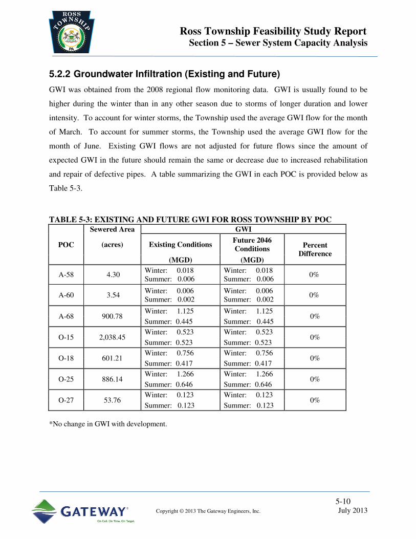
Ross Township Feasibility Study Report Section 5 – Sewer System Capacity Analysis
5-10
Copyright © 2013 The Gateway Engineers, Inc. July 2013
5.2.2 Groundwater Infiltration (Existing and Future)
GWI was obtained from the 2008 regional flow monitoring data. GWI is usually found to be
higher during the winter than in any other season due to storms of longer duration and lower
intensity. To account for winter storms, the Township used the average GWI flow for the month
of March. To account for summer storms, the Township used the average GWI flow for the
month of June. Existing GWI flows are not adjusted for future flows since the amount of
expected GWI in the future should remain the same or decrease due to increased rehabilitation
and repair of defective pipes. A table summarizing the GWI in each POC is provided below as
Table 5-3.
TABLE 5-3: EXISTING AND FUTURE GWI FOR ROSS TOWNSHIP BY POC
POC
Sewered Area GWI
(acres) Existing Conditions Future 2046 Conditions
Percent Difference
(MGD) (MGD)
A-58 4.30 Winter: 0.018 Summer: 0.006
Winter: 0.018 Summer: 0.006
0%
A-60 3.54 Winter: 0.006 Summer: 0.002
Winter: 0.006 Summer: 0.002
0%
A-68 900.78 Winter: 1.125 Winter: 1.125
0% Summer: 0.445 Summer: 0.445
O-15 2,038.45 Winter: 0.523 Winter: 0.523
0% Summer: 0.523 Summer: 0.523
O-18 601.21 Winter: 0.756 Winter: 0.756
0% Summer: 0.417 Summer: 0.417
O-25 886.14 Winter: 1.266 Winter: 1.266
0% Summer: 0.646 Summer: 0.646
O-27 53.76 Winter: 0.123 Winter: 0.123
0% Summer: 0.123 Summer: 0.123
*No change in GWI with development.

5-11
Copyright © 2013 The Gateway Engineers, Inc. July 2013
5.2.3 Estimation Process for Unmonitored Areas
The Township had to determine a way to estimate flows in areas where regional or additional
flow monitors required further refinement for evaluation purposes. This was done by adding an
additional design meter at locations which needed reassessed. Estimated design flows were
prepared for POC O-27 at the two interconnections to PWSA along Oakdale Street, the section
of A-68 at the interconnection with Shaler Township along Hodil Road and the section of O-25
at the interconnection with PWSA along Cliffview Road. These sections of sewer were
estimated in order to more accurately split the flow from downstream meters which were located
in adjacent municipalities. After a review of the available meter data, the Township chose a base
meter to determine flows for a particular design area. The base meter had similar topography,
impervious cover, density of houses, and age of system compared to the design area. The area of
the unmonitored sewershed was found using GIS mapping. This area was divided by the area of
the base meter to find a ratio of unmonitored meter / base meter. Multiplying the base meter
BWWF/house and GWI/inch-mile, the Township was able to estimate the BWWF and GWI of
the design area. Design storms for the area were determined by utilizing the RTK values from
the base meter, and the acreage, BWWF and GWI. The 3RWW RTK spreadsheets for summer
and winter were used to find the 1-, 2-, 5- and 10-year design storms for the new estimated flow
area. A table listing all estimated meters is included below as Table 5-4. Figure 11 shows the
location of all flow estimate meters located in the Township.
TABLE 5-4: ESTIMATED METERS FOR ROSS TOWNSHIP
Estimated Meter Name POC Base Meter Used to Simulate
LBs_1162615 A-68 A6800_-IM_-S-31_
LBs_1258938 O-15 ALCOSAN Lower Ohio Model
LBs_1161446 O-15 ALCOSAN Lower Ohio Model
LBs_1161096 O-15 ALCOSAN Lower Ohio Model
LBs_1163013 O-25 O2500_-MB_-L-05_
LBs_1162012 O-27 A6800__-IM_-S-31_
LBs_1162013 O-27 A6800__-IM_-S-31_

5-12
Copyright © 2013 The Gateway Engineers, Inc. July 2013
5.3 Preliminary Flow Estimates
Preliminary flow estimates were completed by the individual POCs. Please refer to the POC
reports attached for information regarding the steps taken to develop the PFE’s. The submitted
PFE results are available for review and are attached in Appendix G. A table summarizing the
RDII for the Township’s portion of flows per POC is included below, as Table 5-5.
TABLE 5-5: EXISTING AND FUTURE RDII FOR ROSS TOWNSHIP BY POC
RDII
Existing Conditions Future 2046 Conditions
(MGD) (MGD)
POC
Sewered Area 1Year 2 Year 5Year 10 Year 1 Year 2 Year 5 Year 10 Year
(acres)
A-58 4.30 0.04 0.04 0.05 0.05 0.04 0.04 0.05 0.05
A-60 3.54 0.02 0.02 0.02 0.03 0.02 0.02 0.02 0.03
A-68 900.78 3.56 4.23 5.18 5.96 4.04 4.79 5.86 6.74
O-15 2,038.45 2.08 2.53 3.18 4.56 2.34 2.85 3.57 4.12
O-18 601.21 3.76 4.47 5.48 6.29 4.12 4.90 5.99 6.88
O-25 886.14 4.62 5.49 6.73 7.73 8.98 10.60 12.88 14.73
O-27 53.76 2.92 3.48 4.29 4.93 2.99 3.58 4.39 5.06
Calculated as Peak Flows – Dry Weather Flows (were only calculated for the Controlling Season)

Ross Township Feasibility Study Report Section 5 – Sewer System Capacity Analysis
5-13
Copyright © 2013 The Gateway Engineers, Inc. July 2013
5.4 Capacity Deficient Sewers
Accepted engineering practice for the design of sanitary sewers provides for foreseeable future
flows. This results in sewer capacity where the current and future flows are transported within
the pipe system without surcharging, basement backups, manhole pops, or overflows and
includes a factor of safety. In the current analyses required for the Feasibility Study under the
Orders, the possibility exists for a portion of the sanitary sewer system to be slightly over
capacity. Under these conditions, where the remedy could be extremely costly on a per foot
basis, the engineer may want to consider the extent of surcharging. The engineer could then
evaluate whether limited surcharge is appropriate for submission to the regulatory agencies for
their review. Operating sewers in consistent surcharge (especially where the original design did
not intend such operation) can result in continued deterioration of the sewer system as well as
potential exfiltration. This could cause the eventual undermining of the sewer line potentially
resulting in surface or sewer collapse/breaks, etc. Older systems, particularly those with less
resilient joints or structurally weakened by cracks, can sustain physical damage when operated
under surcharge. Accelerated pipe failure associated with cyclical surcharge/non-surcharge
operation is a risk to be considered.
To satisfy the requirement of System Capacity Analysis, capacity maps of the entire municipal
sewer system were developed per POC for the 2- and 10- year design storms and are attached as
Figures 12-21. Based on the small size of POC’s A-58 and A-60 within Ross Township,
capacity tables replaced the capacity maps and are attached as Appendix J and indicate no
capacity issues are present. The capacity map reports the estimated flow in every pipe segment
for the 1-, 2-, 5- and 10-year design storms. It also reports the available capacity of each
corresponding pipe segment based on “Manning’s Equation.” The pipe segment flow is
compared to the pipe segment capacity to determine the level of flow of the pipe or the percent
capacity used during each design storm event. The map specifically highlights the pipe segments
that exceed capacity. In addition, the analysis provides the necessary evidence to show that the
remainder of the sewer segments have sufficient capacity during the 1-, 2-, 5- and 10-year design
storm. The capacity map was developed using the following procedures:

5-14
Copyright © 2013 The Gateway Engineers, Inc. July 2013
1. Development of Draft Capacity Map
a. Initial Flow Monitoring
The flow data collected during the 2008 RCSFMP conducted by ALCOSAN, was
analyzed by 3RWW. The deconstructed hydrographs were used to produce dry weather
flows for each of the meter areas in the study. These values were reviewed by the
Township Engineer in which the meter was located using comparisons to population
estimates and water use estimates. Once the dry weather flows were verified, they
needed to be adjusted to future (2046) conditions using percentage increase factors
supplied by the SPC. Refer to Section 5.2.1.2. For meters that included multiple
municipalities, the percentage increase factor for each municipality involved was
multiplied by their percentage of the flow to obtain a weighted increase factor. The SPC
population data which was used to determine the adjustment factor is attached as
Appendix H. This factor was used to adjust the BWWF to 2046 estimates.
GWI and RTK values for the 2008 RCSFMP meters were also produced by 3RWW from
the deconstructed hydrographs. GIS mapping was used to determine the contributing
acreage to each meter. This information was then entered into the design storm
spreadsheets (developed by 3RWW) to produce each meter’s 1-, 2-, 5- and 10-year
summer and winter design storm peak flows. The peak flows, GWIs, BWWFs,
inches/miles of sewer, customer counts and acreage for each meter were then compiled
into a single database summarizing all flow data for the Township.
b. Development of water usage
In lieu of water records, the Township estimated 250 gallons of water per EDU. Each
address point and corresponding water estimate was then connected to the nearest pipe in
the system with a lower elevation. A map of each address point and its connection was
reviewed to ensure that all points had reasonable water estimates and connected to the
system in a logical manner.

5-15
Copyright © 2013 The Gateway Engineers, Inc. July 2013
c. Interconnection Flows
The Township had to develop a process to determine flows in areas where cross
connections occurred from other communities, called interconnections. Interconnections
with flow coming into Ross Township from the Town of McCandless, Shaler Township,
Franklin Park Borough, and the Borough of Bellevue are shown on the capacity maps
attached as Figures 12-21. Flows at interconnections were calculated by determining
service count and inches/miles of pipe upstream of the interconnection and using the data
from the closest flow meter. The interconnection flow was set up as a design point in the
mapping system. A database was developed to keep track of all interconnections flows.
The database and design point flows were updated each time the upstream community
mapping or meters changed. For a complete list of all interconnections, refer to the
interconnection table attached in Appendix I.
d. Equalization (E.Q.) Tanks
There are no equalization tanks in the Township.
e. Pump Stations
There are no pump stations in the Township.
f. Capacity Calculation Process
The Township’s GIS mapping system was used as the primary collection location for all
layout information including depths of manholes, pipe sizes, materials, flow directions,
and slopes. Pipe segments that were not surveyed were assigned a minimum slope per
the PADEP Domestic Wastewater Facilities Manual requirements as listed below in
Table 5-6:

5-16
Copyright © 2013 The Gateway Engineers, Inc. July 2013
TABLE 5-6: ASSIGNED MINIMUM SLOPE PER PIPE DIAMETER
Sewer Size Minimum Slope in Feet per 100 Feet.
6” 0.600
8” 0.400
10” 0.280
12” 0.220
14” 0.170
15” 0.150
16” 0.140
18” 0.120
21” 0.100
24” 0.080
27” 0.067
30” 0.058
36” 0.046
GWI flow for each meter was distributed to each upstream pipe segment based on the
pipe length and size. This was added to the water estimate flow of each service
connection on the pipe to obtain that segments total dry weather flow. This dry weather
flow was then combined with the next downstream segments GWI and water record flow
to get a total dry weather flow for that pipe. This process was repeated with each
downstream segment to prepare a dry weather flow for each pipe segment in the system.
To determine the peak flow rate (for the 1-, 2-, 5- and 10- year design storm) the total dry
weather flow was multiplied by the same dry weather to peak flow ratio for the
downstream meter, for each pipe segment. The process used makes the conservative
assumption that there is no time delay for the flow to be routed downstream through each
pipe segment.
5-17
Copyright © 2013 The Gateway Engineers, Inc. July 2013
The allowable capacity in the pipe was calculated using the pipe size, slope and
roughness coefficient in conjunction with “Manning’s Equation”. The design storm flow
and allowable capacity values were compared to produce a map showing the potential
locations of over capacity pipes. The over capacity pipe segments were characterized by
the percentage of the pipe area, which was over capacity. For this calculation, it was
assumed that the CSOs and SSOs were not allowed to discharge any flow. Pump
stations, grinder pumps, backflow preventers, overflows and equalization tanks are also
shown on the map. The percentage of pipe area over capacity was shown on the map.
2. Revision of Draft Capacity Map
After the capacity map was prepared, it was reviewed for potential problems with the
slope assumptions made and data used. The assumptions and solutions are as follows:
a. Revised Slopes (Review of Assumed Slopes)
Potentially over capacity/flooded pipe segments, which were calculated using the
assigned minimum slopes (due to lack of survey data in non-critical sewer areas), were
identified on the map. If possible, the manholes in these areas were surveyed using
Virtual Reference Station (VRS) surveying equipment to obtain actual pipe invert
elevations. Conventional survey was utilized in areas where small slope variances could
greatly affect flow calculations. In areas where manholes could not be surveyed because
they were buried or inaccessible to survey, slopes were conservatively estimated by
assuming continuous slope from the next upstream and downstream manhole or using the
local surface area contours and manhole depths to assume elevations.
b. Review of Pipe Sizes
Pipe sizes were reviewed in capacity limited areas to be sure correct values were used. If
pipe sizes in the map database, available CCTV videos or field inspection forms did not
match, field work was done to verify actual pipe diameter.

5-18
Copyright © 2013 The Gateway Engineers, Inc. July 2013
c. Review of Pump Station Peaking
There are no pump stations in the Township.
d. Review of Unmetered Areas
Unmetered areas were then identified and reviewed. These areas were assigned a design
point using a similar area meter flow (refer to Section 5.2.3).
e. Review of Combined/Separate System Interaction
There are no combined sewer areas in the Township.
f. Review of Split Flows
If a manhole or regulator was found which had more than one possible outflow pipe, a
field check was completed. During the field check, the Township representative
reviewed flow directions, outlet elevations and the percentage split of flow per pipe
segment. After the field work was complete, regulators were created in the map database
to split the flow at these points. This was done by either inserting a percentage per pipe
or limiting the flow to the main pipe with the remainder being distributed to the other
outlet pipes.
g. Mapping updates
Through the ACO, CCTV was conducted on the sewers in the system. As a result of this
CCTV, map updates were completed as they were found of additional pipes and layout
changes. These changes were applied to the map database and flows were re-distributed
based on additional revised mapping edits.

5-19
Copyright © 2013 The Gateway Engineers, Inc. July 2013
h. Overall Map Data Check
The overall system was then reviewed to confirm the flows. A QA/QC was conducted
checking the capacity map calculated flow against the actual meter readings. Also, a
flow continuity check was conducted by confirming that each downstream meter had an
appropriate (greater) flow then the upstream meter.
3. Re-metering Based on Review and Revision
There was no additional metering conducted by Ross Township.
4. Review and Revision of Updated Capacity Map
The updated capacity mapping was reviewed again using the techniques described in sections
A through H above as required and the capacity recalculated. A check of the meter flow
against the calculated capacity flow from the mapping was conducted. In areas of multiple
meters and water record discrepancies, a correction factor was applied to make areas match
close to metered values. This factor was applied to account for metering discrepancies and
timing issues. The updates (per sections A through H) and capacity recalculating process
was reiterated until it was determined that all assumptions and data were consistent with
sound engineering judgment.
5. Final Confirmation
Once all engineering assumptions were made and the capacity maps finalized, the
information was compared (in POC’s where possible) with the model to confirm our analysis
was properly calculating capacity in the sewer segments. The capacity map was reviewed
with municipal staff to confirm or deny capacity limited areas. Once all segments with
significantly insufficient capacity were confirmed, alternatives were developed to address the
capacity concerns.

5-20
Copyright © 2013 The Gateway Engineers, Inc. July 2013
5.4.1 Existing Basement Flooding Areas–History and Locations
There are no known records of basement flooding events in the Township; however, there are
backwater valves installed at the following locations: 120 Charterwood Drive, 121 Oxbridge
Drive and 213 Amity Drive.
5.4.2 Capacity Requirements for Various Design Storms and Levels of Protection
The capacity maps for the 2- and 10- year design storms are attached as Figures 12-21. The
maps show areas of flow restriction within the sewer system. In addition, the areas of limited
capacity for the 2- and 10-year design storms are described below, per POC.
A-58:
No capacity issues have been discovered in this area of the Township. See Appendix J for
information regarding the POC A-58 capacity issues.
A-60:
No capacity issues have been discovered in this area of the Township. See Appendix J for
information regarding the POC A-60 capacity issues.
A-68:
2 Year Design Storm Capacity Issues – The municipal interceptor from MH #4305 to the
interconnection with Shaler Township is shown to be 100% over capacity throughout the run.
Three pipe segments on Amity Drive from MH #873 to MH #339 were also discovered to range
from 50% to over 100% over capacity. This was confirmed when compared to the ALCOSAN
model results. See Figure 12 for the 2 year design storm capacity analysis of POC A-68.
10 Year Design Storm Capacity Issues – The municipal interceptor from MH #4305 to the
interconnection with Shaler Township is shown to be 100% over capacity throughout the run.
Three pipe segments on Amity Drive from MH #873 to MH #339 were also discovered to be
100% over capacity. This was confirmed when compared to the ALCOSAN model results. See
Figure 13 for the 10 year design storm capacity analysis of POC A-68.

5-21
Copyright © 2013 The Gateway Engineers, Inc. July 2013
O-15:
2 Year Design Storm Capacity Issues – There are no capacity issues in pipes owned by the
Township in this area. Please refer to the POC report attached in Appendix D for capacity issues
along the shared interceptor. See Figure 14 for the 2 year design storm capacity analysis of POC
O-15.
10 Year Design Storm Capacity Issues – There are no capacity issues in pipes owned by the
Township in this area. Please refer to the POC report attached in Appendix D for capacity issues
along the shared interceptor. See Figure 15 for the 10 year design storm capacity analysis of
POC O-15.
O-18:
2 Year Design Storm Capacity Issues – Five segments to the East of I-279 from MH #3780 to
MH #2209 range from 8% to greater than 100% over capacity. Areas shown to be 100% over
capacity include pipe segments along the municipal interceptor from MH #2135B to the
interconnection with Avalon Borough and along Forest Avenue from MH #2098 to the
interconnection with the Borough of Bellevue. See Figure 16 for the 2 year design storm
capacity analysis of POC O-18.
10 Year Design Storm Capacity Issues – Areas shown to be 100% over capacity include pipe
segments from MH #3785 to MH #3782, along the municipal interceptor from MH #9013 to the
interconnection with Avalon Borough and along Forest Avenue from MH #707 to the
interconnection with the Borough of Bellevue. See Figure 17 for the 10 year design storm
capacity analysis of POC O-18.
O-25:
2 Year Design Storm Capacity Issues – The municipal interceptor along Denny Park Road and
Jacks Run Road has pipe segments ranging from 20% over capacity to 100% over capacity from
MH #5227 to MH #1218. It was also discovered that there are numerous pipe segments along
Jacks Run Road near the interconnections with the Borough of Bellevue that range from 5% over
to 30% over capacity. This issue was confirmed by comparison to the ALCOSAN model. See
Figure 18 for 2 year design storm capacity analysis of POC O-25.

5-22
Copyright © 2013 The Gateway Engineers, Inc. July 2013
10 Year Design Storm Capacity Issues – The municipal interceptor along Denny Park Road and
Jacks Run Road has pipe segments ranging from 20% over capacity to 100% over capacity from
MH #1012 to MH #1218. It was also discovered that there are numerous pipe segments along
Jacks Run Road near the interconnections with the Borough of Bellevue that range from 10%
over to 30% over capacity. This issue was confirmed by comparison to the ALCOSAN model.
See Figure 19 for 10 year design storm capacity analysis of POC O-25.
O-27:
No capacity issues have been discovered in this area of the Township. See Figures 20 and 21 for
the 2- and 10-year design storm capacity analysis of POC O-27.
5.5 Overflow Frequency and Volume
There are no constructed overflows in the Township; however, there are known manhole
overflows along the A-68 interceptor.

Ross Township Feasibility Study Report Section 6 – CSO/SSO Control Goals
6-1
Copyright © 2013 The Gateway Engineers, Inc. July 2013
6.0 CSO/SSO CONTROL GOALS
Water quality issues are the driving force behind the ALCOSAN CD and Municipal COA and
ACO requirements. These requirements stem from the existing water quality criteria in the local
streams that are not being met, some as a result of CSOs and SSOs. CSO and SSO control goals
were developed by ALCOSAN and each municipality so that water quality criteria will be met
after implementation of the regional WWP that includes municipal alternatives.
The detailed methodology that was used to develop the CSO and SSO control goals is described
in the FSWG Document 031 “Water Quality Based Approach to Feasibility Study
Development”. The CSO and SSO control goals that were selected are provided in the following
section.
6.1 Background for Selection of Control Level
6.1.1 CSO Control Level
There are no combined sewers in the Township.
6.1.2 SSO Control Level
Separate sanitary sewers are typically designed to accept only sanitary sewage from residential,
commercial and industrial areas of any given municipality. As a result of aging or improperly
constructed and maintained infrastructure, these sewers are subjected to high flows during wet
weather events. These excessive flows result in SSOs, and/or basement flooding. By definition,
SSOs are illegal and need to be controlled.
During the preliminary discussions in the FSWG meeting on March 26, 2009, the PADEP
introduced a concept to be used for establishing separate sanitary transport and SSO control
criteria.

Ross Township Feasibility Study Report Section 6 – CSO/SSO Control Goals
6-2
Copyright © 2013 The Gateway Engineers, Inc. July 2013
SSO Control and Separate Sanitary Sewer Transport Capacity Criteria
• Develop a “knee-of-the-curve” analysis utilizing the 1, 2, 5, and 10-year, 24-hour
storms at a minimum to determine the break-even point for SSO control. The design
rainfall depths for the design storms should match rainfall depths used or proposed by
ALCOSAN. This evaluation will be performed under the auspices of the FSWG and the
approach and results will be summarized in a different (later) document.
• The design storm approach acknowledges that a 2-year summer rainfall that occurs when
there is snow on the ground would result in runoff that exceeds the intended 2-year
summer storm design. Given this possibility, the FSWG developed a methodology that
includes the selection of a design month. This design month, in addition to the selected
design storm return frequency, would represent the overall intended design conditions.
• Additional discussion was developed around the idea of matching/using the selected
design storm used by ALCOSAN for its separate sanitary sewer interceptors.
For SSO design, the 1-, 2-, 5-, and 10- year design storms were evaluated. This report
summarizes the findings for the 2- and 10- year design storms. For these storms, winter and
summer conditions were evaluated and the highest value for peak and volume were chosen.

Ross Township Feasibility Study Report Section 6 – CSO/SSO Control Goals
6-3
Copyright © 2013 The Gateway Engineers, Inc. July 2013
6.2 Recommendations for Control Levels
The presented alternatives for each POC were designed to 2- and 10- year design storm control
levels. During the alternative design and cost estimation process it was found that the
differences between the 2- and 10- year level of control did not yield significant differences in
projects or estimated construction costs, therefore the Township chose the 10- year design storms
for all of the preferred alternatives. For the A-68 sewershed, the winter storm was used in the
analysis, as it had the greatest impact on the system. For all of the remaining sewersheds the
summer design storms created the highest peak flow rates and therefore were used for analysis.
Through the analysis it was determined that no internal projects are required in POCs A-58, A-
60, O-15 and O-27, as the Ross Township owned lines are already capable of conveying a 10-
year design storm.

Ross Township Feasibility Study Report Section 7 – Alternative Evaluation
7-1
Copyright © 2013 The Gateway Engineers, Inc. July 2013
7.0 ALTERNATIVE EVALUATION (INTERNAL MUNICIPAL)
Once suitable technologies and the best possible sites to house them were identified, a list of
alternatives to be evaluated was developed for each problem. This list provides an identification
of all alternatives evaluated and includes the respective technologies involved, sites identified
and any other variations compared to similar alternatives (for example, a parallel pipe could be
routed in several ways).
For Ross Township, alternatives were developed for all sanitary sewers with projected flows in
excess of 50% over capacity. Areas under 50% over capacity were not evaluated due to
metering inaccuracies, modeling inaccuracies and lack of overflow and surcharge evidence.
These areas will continued to be monitored by Township staff, and if evidence shows capacity
issues occurring, corrective measures will be taken at that time. A list of the alternatives that
were developed for evaluation for the Township is provided below, per POC. Maps depicting
each proposed alternative are attached in Appendix K.
A-58:
No alternatives are required within the Township owned sewers in A-58 for a 10-year design
storm.
A-60:
No alternatives are required within the Township owned sewers in A-60 for a 10-year design
storm.
A-68:
Alternative 1A – Alternative 1A includes the upsizing of approximately 4,600 LF of pipe
ranging from 12” to 18” in size along the main municipal interceptor from MH #4305 to MH
#4086, the upsizing of 330 LF of 12” pipe from MH #873 to MH #339 and the installation, and
operation and maintenance of, a 1.557 MGD storage tank after MH #4086, to control flows into
Shaler Township. This alternative will control the 10-year design storm.

Ross Township Feasibility Study Report Section 7 – Alternative Evaluation
7-2
Copyright © 2013 The Gateway Engineers, Inc. July 2013
Alternative 1B –Alternative 1B includes the construction of approximately 3,300 LF of 10”
parallel sewer along the main municipal interceptor, from MH #4826 to MH #4065, the upsizing
of approximately 1,600 LF of pipe ranging in size from 12” to 18”, from MH #4305 to MH
#4826, MH #873 to MH #339 and MH #4065 to MH #4086 and the installation, and operation
and maintenance of, a 1.557 MGD storage tank after MH #4086. This alternative will control
the 10-year design storm.
Alternative 1C – Alternative 1C includes the upsizing of approximately 4,600 LF of pipe
ranging from 12” to 18” in size along the main municipal interceptor from MH #4305 to MH
#4086, the upsizing of 330 LF of 12” pipe from MH #873 to MH #339 and the installation, and
operation and maintenance of, a 0.912 MGD storage tank after MH #4086, to control flows into
Shaler Township. This alternative will control the 2-year design storm.
Alternative 1D –Alternative 1D includes the construction of approximately 3,300 LF of 10”
parallel sewer along the main municipal interceptor, from MH #4826 to MH #4065, the upsizing
of approximately 1,600 LF of pipe ranging in size from 12” to 18”, from MH #4305 to MH
#4826, MH #873 to MH #339 and MH #4065 to MH #4086 and the installation, and operation
and maintenance of, a 0.912 MGD storage tank after MH #4086. This alternative will control
the 2-year design storm.
O-15:
No alternatives are required within the Township owned sewers in O-15 for a 10-year design
storm. Please refer to the attached O-15 POC report attached in Appendix D, for information
regarding projects along the shared interceptor.

Ross Township Feasibility Study Report Section 7 – Alternative Evaluation
7-3
Copyright © 2013 The Gateway Engineers, Inc. July 2013
O-18:
Alternative 2A: Alternative 2A includes the upsizing of approximately 5,200 LF of pipe
ranging from 8” to 24” in size along the main municipal interceptor from MH #3780 to MH
#9101. Also included is approximately 450 LF of 21” parallel sewers from MH #2136 to MH
#2135B under I-279. This alternative will control the 10-year design storm.
Alternative 2B: Alternative 2B includes the upsizing of approximately 4,500 LF of pipe
ranging from 8” to 24” in size along the main municipal interceptor from MH #3780 to MH
#9101. Also included is approximately 1,100 LF of parallel sewers ranging from 12” to 21”
from MH #2139 to MH #2135B. This alternative will control the 10-year design storm.
Alternative 2C: Alternative 2C includes the upsizing of approximately 5,000 LF of pipe
ranging from 15” to 21” in size along the main municipal interceptor from MH #2138 to MH
#9101 off of Union Avenue. Also included is approximately 450 LF of 21” parallel sewers from
MH #2136 to MH #2135B under I-279. This alternative will control the 2- year design storm.
Alternative 2D: Alternative 2D includes the upsizing of approximately 5,000 LF of pipe
ranging from 12” to 21” in size along the main municipal interceptor from MH #3780 to MH
#9101. This alternative will control the 2-year design storm.
O-25:
Alternative 3A: Alternative 3A includes the upsizing of approximately 3,400 LF of pipe
ranging from 12” to 15” in size along the main municipal interceptor from MH #1388 to MH
#1218. Also included are the removal of the diversion MH #2092 and the upsizing of
approximately 300 LF of sanitary sewer to 10” from MH #707 to MH #2092. This alternative
will control the 10-year design storm.

Ross Township Feasibility Study Report Section 7 – Alternative Evaluation
7-4
Copyright © 2013 The Gateway Engineers, Inc. July 2013
Alternative 3B: Alternative 3B includes the upsizing of approximately 1,400 LF of pipe
ranging from 12” to 15” in size along the main municipal interceptor from MH #1222 to MH
#1218. Also included are the removal of the diversion MH #2092 and the upsizing of
approximately 300 LF of sanitary sewer to 10” from MH #707 to MH #2092. This alternative
will control the 2-year design storm.
O-27:
No alternatives are required within the Township owned sewers in O-27 for a 10-year design
storm.
Table 7-1 lists all of the internal alternatives for the Township by POC. Maps for each of the
alternatives are attached in Appendix K.

Ross Township Feasibility Study Report Section 7 – Alternative Evaluation
7-5
Copyright © 2013 The Gateway Engineers, Inc. July 2013
TABLE 7-1: LISTING OF ALTERNATIVES EVALUATED FOR ROSS TOWNSHIP PER POC
POC Alternative Name System Type Control Level Description
A-58 N/A N/A 10 Year Design Storm There are no 10 year design storm issues
within the Township sewers.
A-60 N/A N/A 10 Year Design Storm There are no 10 year design storm issues
within the Township sewers.
A-68 Alternate 1A Upsizing and Storage
Tank
10 Year Design Storm Upsizing of municipal interceptor and
installation of a storage tank.
Alternate 1B Parallel, Upsizing and
Storage Tank
10 Year Design Storm Run a parallel sewer combined with minor
upsizing and the installation of a storage tank.
Alternate 1C Upsizing and Storage
Tank
2 Year Design Storm Upsizing of municipal interceptor and
installation of a storage tank.
Alternate 1D Parallel, Upsizing and
Storage Tank
2 Year Design Storm Run a parallel sewer combined with minor
upsizing and the installation of a storage tank.
O-15 N/A N/A 10 Year Design Storm There are no 10 year design storm issues
within the Township sewers.
O-18 Alternate 2A Upsizing 10 Year Design Storm Upsizing of existing municipal interceptor.
Alternate 2B Upsizing and Parallel
Sewer System.
10 Year Design Storm Upsizing of existing municipal interceptor with
parallel sewers near the I-279 underpass to
Center Avenue.

Ross Township Feasibility Study Report Section 7 – Alternative Evaluation
7-6
Copyright © 2013 The Gateway Engineers, Inc. July 2013
POC Alternative Name System Type Control Level Description
O-18 Alternate 2C Upsizing 2 Year Design Storm Upsizing of existing municipal interceptor.
Alternate 2D Upsizing and Parallel
Sewer System.
2 Year Design Storm Upsizing of existing municipal interceptor with
parallel sewers near the I-279 underpass to
Center Avenue.
O-25 Alternate 3A Upsizing 10 Year Design Storm Upsizing of existing municipal interceptor.
Alternate 3B Upsizing 2 Year Design Storm Upsizing of existing municipal interceptor.
O-27 N/A N/A 10 Year Design Storm There are no 10 year design storm issues
within the Township sewers.

Ross Township Feasibility Study Report Section 7 – Alternative Evaluation
7-7
Copyright © 2013 The Gateway Engineers, Inc. July 2013
7.1 Evaluation Criteria Development
The alternatives were evaluated based on the following criteria. The first and most important
criteria were the impact of how any potential overflows would affect the community and nearby
watersheds. Next the total cost of the project and the O&M cost to the community was reviewed
and finally the constructability was considered as well as minimizing the total disturbance to the
community from construction.
7.2 Cost Estimates
Once alternatives were developed, a cost estimate was prepared for each potential project using
the ACT spreadsheet supplied by 3RWW. The detailed cost estimates are attached in Appendix
L. For all work that was proposed to be completed across or along roadways, it was assumed
that full roadway replacement would be required. Table 7-2, lists all of the alternatives evaluated
along with their total present worth cost.

Ross Township Feasibility Study Report Section 7 – Alternative Evaluation
7-8
Copyright © 2013 The Gateway Engineers, Inc. July 2013
TABLE 7-2: LISTING OF ALTERNATIVES EVALUATED FOR ROSS TOWNSHIP PER POC WITH PRESENT WORTH COSTS
POC Alternative
Name System Type Control Level Description
Total Present Worth Cost
A-58 N/A N/A 10 Year Design
Storm
There are no 10 year design storm issues within
the Township sewers. $0.00
A-60 N/A N/A 10 Year Design
Storm
There are no 10 year design storm issues within
the Township sewers. $0.00
A-68 Alternate 1A Upsizing and Storage
Tank
10 Year Design
Storm
Upsizing of municipal interceptor and installation
of a storage tank. $8,945,000.00
Alternate 1B Parallel, Upsizing and
Storage Tank
10 Year Design
Storm
Run a parallel sewer combined with minor
upsizing and the installation of a storage tank. $8,833,000.00
Alternate 1C Upsizing and Storage
Tank 2 Year Design Storm
Upsizing of municipal interceptor and installation
of a storage tank. $6,162,000.00
Alternate 1D Parallel, Upsizing and
Storage Tank 2 Year Design Storm
Run a parallel sewer combined with minor
upsizing and the installation of a storage tank. $6,050,000.00
O-15 N/A N/A 10 Year Design
Storm
There are no 10 year design storm issues within
the Township sewers. $0.00
O-18 Alternate 2A Upsizing 10 Year Design
Storm Upsizing of existing municipal interceptor. $2,132,000.00

Ross Township Feasibility Study Report Section 7 – Alternative Evaluation
7-9
Copyright © 2013 The Gateway Engineers, Inc. July 2013
POC Alternative
Name System Type Control Level Description
Total Present Worth Cost
O-18 Alternate 2B Upsizing and Parallel
Sewer System.
10 Year Design
Storm
Upsizing of existing municipal interceptor with
parallel sewers near the 279 underpass to Center
Avenue.
$2,083,000.00
Alternate 2C Upsizing 2 Year Design Storm Upsizing of existing municipal interceptor. $1,983,000.00
Alternate 2D Upsizing and Parallel
Sewer System. 2 Year Design Storm
Upsizing of existing municipal interceptor with
parallel sewers near the 279 underpass to Center
Avenue.
$1,297,000.00
O-25 Alternate 3A Upsizing 10 Year Design
Storm
Upsizing of existing municipal interceptor.
Removal of diversion manhole and upsizing of
sanitary sewers.
$865,000.00
Alternate 3B Upsizing 2 Year Design Storm
Upsizing of existing municipal interceptor.
Removal of diversion manhole and upsizing of
sanitary sewers.
$437,000.00
O-27 N/A N/A 10 Year Design
Storm
There are no 10 year design storm issues within
the Township sewers. $0.00
*ACT costs calculated using estimate year of 2010, ENRCCI of 7636, R.S. mean of 100 and present worth methodology of 1.
**Reported price is the ACT total present worth cost of the current year, based on the above data.

Ross Township Feasibility Study Report Section 7 – Alternative Evaluation
7-10
Copyright © 2013 The Gateway Engineers, Inc. July 2013
7.3 Alternative Selection Process
The alternatives were evaluated based on the following criteria. The first and most important
criteria were the impact of how any potential overflows would affect the community and nearby
watersheds. Next the total cost of the project and the O&M cost to the community was reviewed
and finally the constructability was considered as well as minimizing the total disturbance to the
community from construction
7.4 Alternative Evaluation Results
The following projects were selected as the preferred alternatives per POC:
A-58: No alternatives are required within the Township owned sewers.
A-60: No alternatives are required within the Township owned sewers.
A-68: Alternative 1B (parallel and upsizing).
O-15: No alternatives are required within the Township owned sewers.
O-18: Alternative 2B (parallel and upsizing).
O-25: Alternative 3A (upsizing).
O-27: No alternatives are required within the Township owned sewers.

Ross Township Feasibility Study Report Section 7 – Alternative Evaluation
7-11
Copyright © 2013 The Gateway Engineers, Inc. July 2013
7.5 Recommended Alternative Description Per POC
A-58: No alternatives are required within the Township owned sewers.
A-60: No alternatives are required within the Township owned sewers.
A-68: Alternative 1B (parallel and sewerline upsizing) was chosen as the preferred alternative.
This alternative includes the construction of approximately 3,300 linear feet (LF) of 10” parallel
sewer along the main municipal interceptor, from manhole (MH) #4826 to MH #4065, the
upsizing of approximately 1,600 LF of pipe ranging in size from 12” to 18”, from MH #4305 to
MH #4826, MH #873 to MH #339 and MH #4065 to MH #4086 and the installation, and
operation and maintenance of, a 1.557 Million-Gallons/Day (MGD) storage tank after MH
#4086. (This tank was sized to address overflows within Ross Township as well as downstream
overflows in Shaler Township). Prior to the construction and permitting of this alternative, flow
isolation and potential removal of Infiltration/Inflow (I&I) will be completed in order to refine
the sizing of the storage tank.
O-15: No alternatives are required within the Township owned sewers. .
O-18: Alternative 2B (parallel and sewerline upsizing) was chosen as the preferred alternative.
This alternative includes the upsizing of approximately 4,500 LF of pipe ranging from 8” to 24”
in size along the main municipal interceptor from MH #3780 to MH #9101. Also included is
approximately 1,100 LF of parallel sewers ranging from 12” to 21” from MH #2139 to MH
#2135B.
O-25: Alternative 3A (sewerline upsizing) was chosen as the preferred alternative. This
alternative includes the upsizing of approximately 3,400 LF of pipe ranging from 12” to 15” in
size along the main municipal interceptor from MH #1388 to MH #1218. Also included are the
removal of the diversion MH #2092 and the upsizing of approximately 300 LF of sanitary sewer
to 10” from MH#707 to MH #2092.

Ross Township Feasibility Study Report Section 7 – Alternative Evaluation
7-12
Copyright © 2013 The Gateway Engineers, Inc. July 2013
O-27: No alternatives are required within the Township owned sewers.
Completion of the preferred alternatives will remove the identified capacity deficiencies in the
Township for the 10-year design storm. All flows will be conveyed to the interconnections
leaving the Township without overflow, except in A-68 where the addition of a storage tank will
limit the flows entering Shaler Township. Detailed cost estimates of the alternatives for each
POC are included in Appendix L.
Tables 7-3 and 7-4, show the preferred alternatives with construction and O&M costs.

Ross Township Feasibility Study Report Section 7 – Alternative Evaluation
7-13
Copyright © 2013 The Gateway Engineers, Inc. July 2013
TABLE 7-3: SUMMARY OF CAPITAL IMPROVEMENTS FOR RECOMMENDED ALTERNATIVES PER POC FOR ROSS TOWNSHIP POC
Capital Improvements Size/Capacity Estimated
Capital Cost1 A-68 Parallel, Upsizing and Storage Tank 10 Year Design Storm $15,247,000.00
O-15 N/A 10 Year Design Storm $0.00
O-18 Upsizing and Parallel Sewers 10 Year Design Storm $3,674,000.00
O-25 Upsizing Sewers 10 Year Design Storm $1,527,000.00
O-27 N/A 10 Year Design Storm $0.00
A-58 N/A 10 Year Design Storm $0.00
A-60 N/A 10 Year Design Storm $0.00
A-67 See Girty’s Run Report 10 Year Design Storm $0.00
TOTAL $20,448,000.00
TABLE 7-4: COST BREAKDOWN OF RECOMMENDED ALTERNATIVES PER POC FOR ROSS TOWNSHIP
POC Cost Component SSO Control
Capital Cost1 Annual
O&M Cost2 Total Present Worth Cost3
A-68 Alternative 1B $15,247,000.00 $63,000.00 $8,833,000.00
O-15 N/A $0.00 $0.00 $0.00
O-18 Alternative 2B $3,674,000.00 $5,000.00 $2,083,000.00
O-25 Alternative 3A $1,527,000.00 $2,000.00 $865,000.00
O-27 N/A $0.00 $0.00 $0.00
A-58 N/A $0.00 $0.00 $0.00
A-68 N/A $0.00 $0.00 $0.00
A-67 N/A $0.00 $0.00 $0.00
TOTAL $20,448,000.00 $70,000.00 $11,781,000.00 1ACT – Capital Cost Inflated to 2026
2ACT – Annual O&M Costs (Current Year)
3ACT – 2010 Present Worth Cost
Ross Township Feasibility Study Report Section 7 – Alternative Evaluation
7-14
Copyright © 2013 The Gateway Engineers, Inc. July 2013
7.6 Recommended Alternative Operation and Maintenance
The Township’s O&M Procedures are proposed to follow in compliance with the current O&M
Plan; however, additional O&M will be required for the storage tank located in POC A-68 and
for additional parallel sewers proposed. As such, future budgets will be adjusted to include these
additional costs. The current O&M Plan includes the proactive monitoring, examination,
repairing and maintaining of the collection and conveyance system to prevent backups and
overflows before they occur. This is done by completing CCTV inspection of 10 percent of the
sanitary sewers and inspection of 10 percent of the sanitary manholes each year, in order to
develop a repair list of defective sewers and manholes. The plan also includes the preventative
maintenance (annual cleaning) of problematic sewers which have issues such as sags, excessive
debris, roots, critical segments, etc. Close inspection of sewer segments along streams after
significant storm events as well as annual training for municipal staff members is also conducted
as part of the O&M Plan. The Township may also consider implementing a sewer lateral
maintenance ordinance, to limit the I&I from defective, privately owned sewers.
7.7 Stream Removals
There are no areas of direct stream inflow located within the Township.

Ross Township Feasibility Study Report Section 8 – Multi-Municipal Sewershed Recommended Alternatives
8-1
Copyright © 2013 The Gateway Engineers, Inc. July 2013
8.0 Multi-Municipal Sewershed Recommended Alternatives
Table 8-1 below is a summary of recommended alternatives and costs for multi-municipal
sewershed projects. POC A-67 alternatives are included in order to represent an accurate User
Cost analysis for all Ross Township residents. A-67 alternative projects will be paid for by the
Girty’s Run Joint Sewer Authority. For the proposed multi-municipal project descriptions and
cost estimates please refer to the A-68 and O-15 POC reports that are attached in Appendix C
and D.
TABLE 8-1: SUMMARY OF POC RECOMMENDED ALTERNATIVES
POC Description of Alternative Total Project
Cost1
Ross Township
Projected Cost1
A-58 2 year storm, 4 OF/year, option per POC report $5,590,000.00 $20,000.002
A-60 No projects are proposed. $0.00 $0.00
A-67 Storage Option 1 – 2yr – 10 overflows $23,521,000.003 $11,750,000.004
A-68
Conveyance upgrades on the Ross-Shaler
Interceptor, Equalization/Conveyance upgrades
on the Shaler-Rt. 8 Interceptor and Parallel
Conveyance upgrades in Etna.
$31,600,000.00 $3,500,000.005
O-15 Conveyance upgrades of the entire LROC
interceptor. $15,800,000.00 $3,300,000.006
O-18 No projects are proposed. $0.00 $0.00
O-25 No projects are proposed. $0.00 $0.00
O-27 No projects are proposed. $0.00 $0.00
1ACT – Total Present Worth Cost 2Projected Cost based on total population of the sewershed. 3Cost taken from the A-67 Draft POC report dated July 31, 2012, located in Appendix B. 4A-67-Ross Township Costs calculated per percent usage of GRJSA costumers. 5A-68-Ross Township Costs calculated per the segmental approach with dry weather flows. 6O-15-Ross Township Costs derived from LROC agreement information.

Ross Township Feasibility Study Report Section 9 – Financial and Institutional Considerations
9-1
Copyright © 2013 The Gateway Engineers, Inc. July 2013
9.0 Financial and Institutional Considerations 9.1 MOU (Memorandum of Understanding) and Inter-Municipal Agreements
No MOU will be signed by the Township Board of commissioners. The Board acknowledged
the Feasibility Study Report and approved the submittal, at their meeting on July 15, 2013. Any
existing agreements between the multi-municipalities tributary to a common system have been
made available to all municipalities. Any new agreements will be negotiated once an approval of
projects has been received from the regulators.
9.2 Funding Alternatives
Table 9-1 shows the projected amount of total costs to be funded by Ross Township Residents.
TABLE 9-1: SUMMARY OF ROSS TOWNSHIP REQUIRED FUNDING
POC Ross Township Internal
Alternative Costs Ross Township Project Multi-Municipal Alternative Costs
Total Capital Cost
A-581 $0.00 $20,000.00 $20,000.00
A-60 $0.00 $0.00 $0.00
A-67 $0.00 $17,630,000.002 $17,630,000.00
A-68 $15,247,000.00 $6,130,000.00 $21,377,000.003
O-15 $0.00 $5,780,000.00 $5,780,000.00
O-18 $3,674,000.00 $0.00 $3,674,000.00
O-25 $1,527,000.00 $0.00 $1,527,000.00
O-27 $0.00 $0.00 $0.00
TOTAL $50,008,000.00 1) A-58 contributes in part to the A-51 sewershed. Project Cost is based off of the total population of the sewershed.
2) Projected cost to Ross Township Users located within POC A-67 based on the Draft A-67 POC report located in
Appendix B.
3) Shaler Township is projected to contribute approximately $4,000,000.00 towards this portion of a shared
equalization tank; however, no formal negotiations have occurred.

Ross Township Feasibility Study Report Section 9 – Financial and Institutional Considerations
9-2
Copyright © 2013 The Gateway Engineers, Inc. July 2013
The following are available funding methods for sewage improvement projects.
Multi-municipal sharing of resources is often a cost-effective method for managing the continued
O&M of wet weather control facilities. Material, equipment, and labor can be shared between
communities. For example, a sewer vacuum truck owned by one community can be borrowed or
rented by another community for cleaning of an SSO storage facility or pipeline. Municipal
Councils of Governments (COGs) often function in this manner through cooperative action (e.g.
South Hills COG, Turtle Creek COG).
Bonded Indebtedness
Municipalities may issue bonds as a method of funding capital improvement projects. There are
three types of bonds issued for this purpose. General obligation bonds are issued through a
municipality and repaid through local taxes. These bonds typically have a lower interest rate due
to the secured backing of the municipality. Special assessment bonds are issued when certain
properties are recipients of special benefits not available to all the properties in the municipality.
This bond will only benefit the portion of the project that is located within those certain
properties. Special assessment bonds usually carry a higher interest rate and are considered a
greater risk. Revenue bonds are payable from fees and charges assessed for the sewer services
provided by the municipality that sold the bonds. No further backing is required for revenue
bonds. Revenue bonds do not affect a municipality’s ability to borrow money for other projects.
Long-Term Bank Financing
The Township could borrow funds from banks in the form of long-term bank notes for periods of
up to 20 years. Municipal rates are typically less than the prime rates. Long- term bank
financing is subject to a municipal borrowing limit and will decrease the amount available for
other capital projects.

Ross Township Feasibility Study Report Section 9 – Financial and Institutional Considerations
9-3
Copyright © 2013 The Gateway Engineers, Inc. July 2013
Pennvest Financing
The Pennsylvania Infrastructure Investment Authority (PENNVEST) serves the communities
and citizens of Pennsylvania by funding sewer, storm water and drinking water projects
throughout the Commonwealth by providing low cost financial assistance. Grants and loans are
available.
Criteria for receiving assistance are listed below.
1. The proposed project will improve the health, safety, welfare or economic well-being of
the people served.
2. The proposed project must lead to an effective, long-term solution to the problems
experienced.
3. The proposed project is cost effective.
4. The proposed project is consistent with State and other regional plans.
5. The applicant must be capable of operating and maintaining the project upon completion.
6. The proposed project must consolidate systems where such consolidation will effectively
and efficiently serve the customers.
7. The proposed project must not have a detrimental effect on the air, land or water of the
Commonwealth.
PENNVEST may require a certain level of applicant participation in financing the proposed
project. The extent of applicant participation and the reasonableness of the interest rates for
alternative funding sources will be determined by the effect they will have on user rates and the
customer’s ability to pay. The minimum interest rate on any loan is 1%.
Application may be made for advance funding to cover the costs associated with the engineering
design of the proposed project. A separate application is required for construction costs relative
to the project upon completion of the engineering design phase.

Ross Township Feasibility Study Report Section 9 – Financial and Institutional Considerations
9-4
Copyright © 2013 The Gateway Engineers, Inc. July 2013
Community Development Block Grants
U.S. Department of Housing and Urban Development’s (HUD’s) Community Development
Block Grant (CDBG) program provides annual grants on a formula basis to many different types
of grantees through several programs. Monies are funneled through the state to counties that
administer the funds.
CDBG money can be used to pay for projects for those with incomes within published HUD
guidelines. The HUD guidelines stipulate household incomes for varying family sizes.
Community Infrastructure and Tourism Fund (CITF)
The Allegheny County Economic Development, Community Infrastructure and Tourism Fund
(“Community Infrastructure and Tourism Fund” or “CITF”), overseen by the Redevelopment
Authority of Allegheny County (“RAAC”), is intended to provide financial assistance to entities
to facilitate economic development through infrastructure assistance, stabilize or correct existing
infrastructure problems, or plan and prepare sites and buildings for future use.
The CITF is an annual allocation of $6,600,000 for use in Allegheny County funded by the
Commonwealth of Pennsylvania under the Act of July 5, 2004 (P.L. 572, No. 71), known as the
Pennsylvania Race Horse Development and Gaming Act and authorized pursuant to the Act of
July 25, 2007 (P.L.342, No. 53), known as the Pennsylvania Gaming Economic Development
and Tourism Fund Capital Budget Itemization Act of 2007. The funds are made available to
CITF under these Acts “to fund construction, development, improvement and maintenance of
infrastructure projects.”
CITF provides grants and loans to allow municipalities, authorities, councils of government
(COGs), for-profit businesses (loans only), and others, to carry out important infrastructure-
related projects, or, for the acquisition and development of key sites for future use.

Ross Township Feasibility Study Report Section 9 – Financial and Institutional Considerations
9-5
Copyright © 2013 The Gateway Engineers, Inc. July 2013
9.3 User Cost Analysis
A user cost analysis was performed for the current costs per household within the Township.
Information was obtained from the Township regarding the current annual operations and
maintenance expenses for the sanitary sewer system and current annual debt service to determine
the current Township costs per household. The Township’s O&M costs (less ALCOSAN
charges) were then projected from the year 2012 to 2027 using a Consumer Price Index of 2.48.
The ALCOSAN Wet Weather Report projected a user cost for proposed wet weather projects of
$390 per household and $201 per household for normal O&M costs, for 2027, after the
implementation of wet weather projects. These ALCOSAN costs were added to the Township
O&M and debt service costs to determine a projected sewage rate per household in 2027. Table
9-2 illustrates the current and estimated annual user cost per household.
TABLE 9-2: ESTIMATED ANNUAL COST PER HOUSEHOLD AFTER IMPLEMENTATION OF RECOMMENDED ALTERNATIVES
Current Annual Cost
Per Household (2012)
Cost Per Household After Alternatives
(2027)
Existing User Costs ALCOSAN Costs1 $262.00 $410.00
Municipal Costs $201.00 $291.11
Future Costs
ALCOSAN Projects1 $390.00
Municipal Projects2 $312.26
TOTAL $463.00 $1,403.37
1) Obtained from the ALCOSAN Wet Weather Plan (2012)
2) Average User Cost for Ross Township Costumers based on both Ross Township and Girty’s Run
sewer projects.
Ross Township Feasibility Study Report Section 9 – Financial and Institutional Considerations
9-6
Copyright © 2013 The Gateway Engineers, Inc. July 2013
9.4 Affordability
To determine the affordability of the proposed improvements throughout the region, the EPA’s
Long Term Control Plan EZ Template Schedule 6 - Affordability was used. The template is a
planning tool for small municipalities to determine the “Financial Capability” to undertake wet
weather improvement projects. The template was designed for wet weather flows for CSS. The
ALCOSAN sewershed is located in the City of Pittsburgh, which is a CSS. Separate sanitary
sewer flows from upstream communities are transmitted through trunklines that carry combined
flow. In order to address the wet weather issues for the entire region in the ALCOSAN service
area, the LTCP-EZ Template was used for the affordability analysis to standardize the financial
burden so that it can be compared across municipalities. The “Financial Capability” of Low,
Medium, or High Burden is then identified for the municipality, and can be utilized in addressing
the wet weather issues as a region. The Financial Capability measures the impact that a Long
Term Control Plan will have on both the current and future financial capability of the
municipality.
The Financial Capability of a municipality is based on two phases. Phase one of the analysis is
the Residential Indicator (RI). The RI assesses the residential customer’s affordability as
measured by the cost as a percentage of Median Household Income (MHI). The second phase
evaluates the financial capability of the municipality to fund the proposed improvement projects
and future O&M of the projects.
Calculation of the Residential Indicator
To determine the RI, Ross Township staff collected the data required to calculate the annual cost
per household for wastewater collection and treatment to determine the percentage of sanitary
sewer costs with respect to MHI. The data collected included O&M costs of the existing
collection system, current annual debt service related to sanitary sewers, ALCOSAN’s charges
for treatment and conveyance, projected costs for the proposed capital improvements and O&M
with respect to wet weather alternatives to determine the total current and projected wet weather
costs for the Township.

Ross Township Feasibility Study Report Section 9 – Financial and Institutional Considerations
9-7
Copyright © 2013 The Gateway Engineers, Inc. July 2013
Factors utilized in the form were completed by the Township including MHI and the number of
households in the service area. The RI is then calculated by comparing the cost per household to
the MHI. Once the cost per household is determined, the RI is calculated by dividing the cost
per household by the MHI of the municipality, and is then compared to the USEPA criteria for
classifying the financial impact as “Low, Mid-Range, or High.” See Table 9-3 for classifying the
financial impact based on the calculated RI.
TABLE 9-3: RESIDENTIAL INDICATOR TABLE
Calculation of Financial Capability
The second part of the form takes into account the Township’s financial ability to fund the
proposed projects. Financial indicators include debt indicators, socioeconomic indicators, and
financial management indicators.
The Township provided information on current bonds, type of bond, and bond rating to
determine the Bond Rating Benchmark. The Net Debt Benchmark was determined by
calculating direct debt, debt of overlapping entities, which includes school district debt or other
shared debt for joint projects, and the overall net debt as a percent of full market property values.
All of this information is utilized to determine the “Net Debt Benchmark”.
The unemployment rate for the Township was then compared to the national average to
determine the “Unemployment Rate Benchmark”. The MHI is compared to the national average
to determine the “Median Household Income Benchmark”. The “Property Tax Benchmark” is
determined by calculating the property taxes levied and the property tax revenue collection rate
to determine the Collection Rate Benchmark. These factors are averaged to determine the
average financial capability score.
Financial Impact Residential Indicator (Cost as % of MHI)
Low Less than 1% of MHI
Mid-Range 1% - 2 % of MHI
High Greater than 2% of MHI

Ross Township Feasibility Study Report Section 9 – Financial and Institutional Considerations
9-8
Copyright © 2013 The Gateway Engineers, Inc. July 2013
The benchmark scores are entered into a matrix to calculate the Financial Capability Indicator
Benchmark. Table 9-4 below show the classifications for the financial indicators.
TABLE 9-4: FINANCIAL INDICTOR TABLE
The results of the RI and the Permittee Financial Capability Indicators analysis are combined in
the Financial Capability Matrix to evaluate the level of financial burden that the wet weather
controls impose on the permittee. See Table 9-5 for the Financial Capability Matrix. The goal
of obtaining this Financial Capability is to determine if the Township is able to borrow the funds
required for the Wet Weather Improvements and if the residents can afford the burden to repay
the debt through user costs. Once the Financial Capability has been determined, the Township
can develop a schedule for the proposed wet weather projects.
TABLE 9-5: FINANCIAL CAPABILITY MATRIX
Permittee Financial
Capability Indicators Score
(Socioeconomic, Debt, and Financial
Indicators)
Residential Indicator
(Cost Per Household as a % of MHI)
Low (Below 1.0%)
Mid-Range (Between 1.0 and
2.0%)
High (Above 2.0%)
Weak (Below 1.5)
Medium Burden High Burden High Burden
Mid-Range (Between 1.5 and 2.5)
Low Burden Medium Burden High Burden
Strong (Above 2.5)
Low Burden Low Burden Medium Burden
Financial Capability Financial Indicator
Weak Less than 1.5
Mid-Range Between 1.5 and 2.5
Strong Greater than 2.5

Ross Township Feasibility Study Report Section 9 – Financial and Institutional Considerations
9-9
Copyright © 2013 The Gateway Engineers, Inc. July 2013
FINANCIAL CAPABILITY ANALYSIS See Appendix M for the completed Schedule 6, CSO Affordability Form completed for the
Township. The Affordability worksheet includes $30,351,000 for preferred alternatives to be
completed prior to 2026, which includes costs for POC A-67 in order to represent an accurate
user cost analysis for all residents located within Ross Township. An annual debt service was
calculated using 6% interest for 20 years. In addition to the Township’s project costs and
increased O&M costs, an increase in user rates from ALCOSAN was projected in the
ALCOSAN Draft Wet Weather Report to be $390 in 2026. All proposed project numbers were
adjusted to 2012 numbers for the basis of comparison.
The Township has a MHI of $61,205 which is higher than the national average of $50,831 for
2012. Currently, the Township’s Financial Capability Indicator is Low without the consideration
of future wet weather issues.
However, adding the projected wet weather costs in 2026 from ALCOSANs Draft Wet Weather
Report dated July 2012, indicates a user cost increase of $390 per household in 2026.
Incorporating this increase to the Township’s residents puts their RI at 1.52% which is in the
Mid Range. EPA standards indicate that anything above 2% MHI in considered High Burden.
The proposed wet weather improvements will put the Township in the Low Burden range for
overall Financial Capability.
The Local Government Unit Debt Act (LGUDA) guidelines limit the Township’s borrowing
ability to approximately $52 million. The Township’s current debt totaling $3.8 million leaves
an available borrowing balance of $48 million for the proposed wet weather projects.

Ross Township Feasibility Study Report Section 10 – Integration of Selected Alternatives
10-1
Copyright © 2013 The Gateway Engineers, Inc. July 2013
10.0 Integration of Selected Alternatives
There are currently no planned ALCOSAN projects that would be affected by the completion of
the proposed Township internal alternative projects. The Township plans to conduct flow
isolation and flow monitoring prior to the design and construction of the proposed projects, to
verify the limits and details of work required. The Township will also continue to review green
infrastructure solutions. The Township may also look toward early action projects in POC’s A-
68 and O-25. The ACHD will be notified if implementation of these projects is pursued by Ross
Township. At this time, the Borough of Bellevue does not have any projects proposed along
their interceptor and will need to verify that it can handle additional Township flow before the
proposed projects can be completed in POC O-18. The Borough of Bellevue has also stated that
it has no plans to complete upgrades downstream of Ross Township in POC O-25 however the
projects proposed to be completed by Ross Township within the POC will not increase the
amount of flow exiting the Township into the Borough of Bellevue.

Ross Township Feasibility Study Report Section 11 – Implementation
11-1
Copyright © 2013 The Gateway Engineers, Inc. July 2013
11.0 Implementation 11.1 Implementation Schedule
On July 15, 2013 the Township Board of Commissioners acknowledged the Feasibility Study
Report and approved submittal. The Township projects will take place concurrently with
neighboring municipal construction projects in order to minimize disturbance and ensure that the
all interconnected systems can handle any additional flow from the Township.
• 2014 through 2026 – Perform flow monitoring and flow isolation and source reduction of
project areas.
• March 2015 – Termination of current ACO.
• December 2015 – Regional negotiation of multi-municipal trunk sewer agreements.
• June 2016 – Negotiation with agencies.
• December 2017 Negotiation/Agreements between municipalities.
• December 2026 – Design/permits/approvals/financing; construction.
*Dates are for completion of the task
11.2 Joint Municipal Planning and Implementation
Cost sharing and timing of projects will need to be discussed amongst the municipalities for
work along shared interceptors.
11.3 Regulatory Compliance Reporting
The Township will comply with all post regulatory compliance reports as mandated by the
regulators.