rv maria s. merian cruise msm09/2 - uni-hamburg.de · rv maria s. merian cruise msm09/2 21.08.2008...
TRANSCRIPT

- 1 -
RV MARIA S. MERIAN Cruise MSM09/2
21.08.2008 – 15.09.2008
St. John’s – Labrador Sea – Baffin Bay – St. John’s
Short Cruise Report
Prof. Dr. Michal Kucera, Chief Scientist Institute of Geosciences, Eberhard Karls Universität Tübingen
Sigwartstrasse 10, 72076 Tübingen, Germany Cruise participants
1. Michal Kucera Chief Scientist GeoTü 2. Ralf Aurahs Plankton sampling, Genetics GeoTü 3. Margret Bayer Plankton sampling GeoTü 4. Anne-Sophie Bayer Plankton sampling GeoTü 5. Fabian Bonitz Sediment sampling GeoTü 6. Annekatrin Enge Micropalaeontology GeoTü 7. Linda Genovesi Micropalaeontology UQAM 8. Christoph Hemleben Micropalaeontology GeoTü 9. Bernd Kohlhepp Sediment sampling GeoTü 10. Tobias Moller Sediment sampling GeoTü 11. Uta Neumann CTD/Mooring IFM-GEOMAR 12. Lea Numberger Biooptical measurements GeoTü 13. Uwe Papenburg CTD/Mooring IFM-GEOMAR 14. Kristina Pascher Plankton sampling GeoTü 15. Stefan Riha CTD/Verankerung IFM-GEOMAR 16. Christina Roth CTD/Verankerung IFM-GEOMAR 17. Tim Russon Sediment sampling Uni. Edinburgh 18. Hartmut Schulz Sediment sampling GeoTü 19. Marit-Solveig Seidenkrantz Micropalaeontology Uni. Aarhus 20. Michael Siccha PARASOUND GeoTü 21. Annika Szameitat Plankton sampling GeoTü 22. Henriette Vinther Micropalaeontology Uni. Aarhus 23. Almuth Winther Physician
- 2 -
Participating Institutions Universität Tübingen (GeoTü) Institut für Geowissenschaften Sigwartstrasse 10 D-72076 Tübingen / Germany www.ifg.uni-tuebingen.de Geological Survey of Denmark and Greenland (GEUS) Øster Voldgade 10 DK-1350 Copenhagen K / Denmark www.geus.dk Leibniz-Institut für Meereswissenschaften (IFM-GEOMAR) Wischhofstr. 1-3 D-24148 Kiel / Germany www.ifm-geomar.de University of Aarhus Department of Earth Sciences DK-8000 Arhus / Denmark www.geo.au.dk University of Edinburgh Grant Institute of Earth Sciences West Mains Road Edinburgh EH9 3JW / UK www.ed.ac.uk Université du Québec à Montréal (UQUAM) Centre de recherche en Géochimie isotopique et en Géochronologie - GEOTOP C.P. 8888, succursale "centre ville" Montréal H3C 3P8 / CANADA

- 3 -
Scientific Programme The RV Maria S MERIAN research cruise MSM09/2 followed a combined programme of physical oceanographic observations in the Labrador Sea and a biological and paleoceanographical programme focussing on plankton and sediment sampling in the Baffin Bay. The cruise track in the Labrador Sea was dictated by the position of the oceanographic profiles and the long-term mooring stations. North of the Davis Strait, the cruise was planned to reach the central Baffin Bay with the lowest salinity surface water (< 32 psu), representing the most extreme plankton habitat. a) Physical oceanography The main objectives of the physical oceanographic programme were observations of the different deep circulation branches in the Labrador Sea and investigations of water mass characteristics and its variability. The focus is on the export of Labrador Sea Water and the other components of North Atlantic Deep Water from the subpolar to the subtropical North Atlantic. These observations form a part of a long-term monitoring project which aims to understand the variability of the Atlantic meridional overturning circulation, a major determinant in global climate. Specifically, the aims of the physical oceanographic investigations during the cruise were to determine:
• Multi-year variability of fresh water fluxes into the convective area • Changes in water mass characteristics in relation to convection activity • The role of eddy fluxes and re-circulation cells with respect to the exchange
between the interior Labrador Sea and the boundary current • Transformation of the deep water masses (inflow vs. outflow) • Variability of the Deep Water export in relation to the large scale forcing
These objectives were followed during the cruise by maintenance work to the extensive mooring array, by direct observations of currents (LADCP) during station work, and through underway measurements of currents between stations (RV Merian’s Ocean Surveyor ADCP). For water mass characterization, CTDO2 stations were made along two sections passing by the moorings. b) Micropalaeontology and paleoceanography Extensive sea-ice cover and strong salinity stratification in the summer make the Labrador Sea and the Baffin Bay potentially the best analogs for glacial conditions in the North Atlantic. This region is an important determinant in global ocean circulation and its dynamics controls climate in Europe. Yet, despite extensive efforts, our ability to reconstruct accurately the properties of North Atlantic polar waters in the past have been hampered by poor understanding of the behaviour of the main proxy carriers, planktonic foraminifera, in these extreme environments. The objective of the biological and paleoceanographic programme of this leg is to take advantage of the unique analogous conditions found in the Baffin Bay and collect data and samples that will make it possible to characterise the relationship between hydrographic conditions and living plankton and benthos across a gradient of salinity stratification and sea-ice extent as well as the transfer of the ecological signals from the plankton into the sedimentary archive. Specifically, the biological and paleoceanographical part of cruise MSM09/2 has been planned to pursue the following objectives:
• Collection of data and samples from the water column to understand how the habitats of planktonic and benthic foraminifera and phytoplankton are affected by the extreme environments of seasonal ice cover and large surface salinity

- 4 -
variations and how information on these pelagic habitats are incorporated into microfossil remains of the plankton.
• Sampling of foraminifera for DNA analyses in order to understand the taxonomy and the genetic diversity of the investigated species and to investigate the gene flow between populations of planktonic foraminifera (in particular N. pachyderma) in the marginal basins of the Arctic.
• Collection of surface sediment samples to characterise the transfer of habitat information into foraminiferal shells during life and its integration and modification during transport into the sediment, in order to facilitate the interpretation of paleoproxy records.
• Collection of sediment cores in the Baffin Bay, which could be used as archives of Holocene and late glacial dynamics of surface water parameters and bentho-pelagic coupling and where the newly developed proxies and ecological models could be tested.
The objectives of the biological oceanographic programme were carried out by following a comprehensive sampling and observation programme throughout the working area involving CTD casts, determination of phytoplankton pigment concentration by fluorescence probe, sampling and filtration of vertical water profiles, continuous pumping of surface waters and stratified plankton hauls; high-resolution sampling was planned for a transect across the northern Labrador Sea and through the central Baffin Bay. The micropalaeontological and paleoceanographical objectives were followed by sampling undisturbed surface sediments by means of a boxcorer and multicorer, including sampling of living benthic foraminifera for ecological observations, culturing experiments and genetic investigations. Sediment cores were collected mainly in the Baffin Bay in locations conducive to preservation of proxy signals and where sediment accumulation during the Holocene promised sediment archives with high temporal resolution.
Cruise narrative The mobilisation of the expedition MSM09/3 began in the port of St. John’s on Newfoundland on August 19, 2008. The participants were busy assemblying sampling gear, mooring components and setting up laboratories until the evening of August 20. With all cruise participants including the physician on board, the MERIAN left the port of St. John’s according to the plan on the morning of August 21, heading NWN towards the shelf edge in the Labrador Sea. Due to excellent weather conditions and calm sea, the ship could steam at 13 kn and reached the first station ahead of schedule on August 22 at 12 UTC. The first station of the first of the two planned oceanographic lines in the Labrador Sea was used to test all equipment. Hardware problems with data transmission from the PARASOUND system and the release system of the multinet have been identified and resolved on the same day. Boxcore samples recovered from 300 m depth showed sediment unsuitable for coring and the test of the gravity corer has thus been postponed towards the second half of the cruise. CTD/LADCP deployment and water sampling from the rosette as well the water filtration bench and sampling of plankton with multinet and by filtering the ship’s uncontaminated seawater supply were all tested successfully. The second of the 17 CTD stations of the first Labrador Sea line was reached on August 22 at 18 UTC and the measurements and sampling along the line proceeded without incidents until August 25. Following a successful deep-sea test of the Multibeam and PARASOUND systems and of the mooring releaser – hydrophone communication on

- 5 -
August 22, the IFM-GEOMAR Kiel long-term oceanographic mooring K9 was successfully re-deployed on August 23. The mooring array broke off from its anchor on May 21, 2008 but was promptly recovered by the Canadian RV Hudson, passing in the vicinity of the site. The mooring was delivered to the MERIAN in St John’s and following maintenance and data capture, it could be reassembled and will continue monitoring the water column properties and water mass movement in the region. On three of the 17 stations of the first oceanographic line, plankton nets and surface sediment samples were taken in addition to the CTD/LADCP measurements. Weather conditions were generally good, although at times due to thick fog, the speed had to be reduced to 8 kn. The first station of the second oceanographic line in the Labrador Sea was reached on August 26 at 15 UTC. Unlike the first oceanographic line, the second line traversed the entire Labrador Sea and the CTD/LADCP measurements were accompanied by plankton sampling (water filtration, multinet, phytoplankton pigment probe) at all 17 stations. All systems worked fine, apart from the phytoplankton pigment probe which failed to record data at several occasions. Sediment sampling took place at three stations. At the first sediment sampling station, in the early hours of August 27, a material fault was discovered on the deep-sea winch wire. Operations were aborted for five hours until the wire could be repaired. The boxcorer failed to close upon sediment contact when operations resumed. The station was abandoned for sediment work. Despite increasingly colder weather, the scientific programme proceeded well with scientists getting a routine in operating gear, sampling and working in 24-hour shifts. On August 27 at 23:30 UTC the scientific programme had to be interrupted due to a medical emergency. One of the scientists of the CTD watch stumbled over the high sill of the door between the hangar and the midship gangway. The scientist fall on her right arm and remained immobile on the floor with arm bent at elbow pointing away from body. The injured remained conscious and called for help. The ship’s physician assisted by ship’s crew repositioned and fixed the arm after applying pain relief medication. Considering that no X-ray was available on ship and the working area for the coming weeks would have been significantly more remote (Davis Strait/Baffin Bay), the captain, the physician and the chief scientist jointly decided to interrupt the scientific programme and seek medical rescue for the injured. Following advice from Canadian authorities, a decision was made to head for the port of St. Anthony on Newfoundland Island at maximum speed (reaching at times 15 kn), where the injured was disembarked to the Canadian search and rescue team and taken to the local hospital for immediate attention. The scientific programme resumed on August 30 at 3 UTC, now running approximately two days behind schedule. This loss of time was, however, immediately partly compensated by an extremely smooth and successful exchange (recovery, maintenance and re-deployment) of the IFM-GEOMAR Kiel mooring array K1, which was completed by 20 UTC on August 30. The rest of the operations along the second oceanographic line went without further incidents, except of the sighting of the first iceberg on September 1. On the same day, a message from the injured scientist has reached us, informing us that she is back in Germany with friends and family and under medical observation. The weather turned rainy, foggy and cold, allowing only a small glimpse of the coast of Greenland near Cap Desolation, which was reached on September 2 at 2 UTC. With all oceanographic work in the Labrador Sea completed, the focus of the rest of the cruise was on plankton ecology, micropalaeontology and sediment sampling in the Davis Strait and Baffin Bay. The transit to the Davis Strait is slower than expected due to thick fog limiting visibility to less than 2 nm. The last station in the Labrador Sea was at 62.5N. The deep-water setting was used to repair the deep-

- 6 -
sea wire to enable the deployment of the gravity corer in the Baffin Bay. Following the repair, surface sediment samples were recovered showing signs of winnowing by deep currents. The station was close to the expected position of the floating telemetry buoy of the IFM-GEOMAR Kiel mooring V434-07, which broke away in the Irminger Sea and drifted in the East Greenland Current since May 2007. Given the time loss and the unfavourable timing of arrival at the presumed position (night), it was decided not to pursue the mooring at this stage but reconsider a recovery when returning back from the Baffin Bay. The Davis Strait was reached on September 3; weather was still foggy and the cold was exacerbated by high humidity, resulting from the sea-surface temperature being several degrees warmer than the air. The sediment sampling station was located on the Sukkertop Bank, 5 nm dowtrack from the planned position since bottom topography and parasound indicated poor sediment yield there. Good samples were recovered with soft silty sediment, highly bioturbated, with living ophiurids. Plankton sampling revealed for the first time during the cruise an assemblage of planktonic foraminifera entirely dominated by N. pachyderma, as is typical for polar waters. The polar circle was crossed during the night of September 4 in the region of the Kong Fredrik IX Land. Sporadic icebergs, fog and the danger of growlers have slowed the ship to 6-8 kn. The position of the first Baffin Bay station was reached at 17 UTC, a CTD cast (from now on without LADCP, which relies on a compass that is in this region useless due to the proximity of the magnetic pole) was used to calibrate the Multibeam and PARASOUND systems and sediment sampling commenced on location identified in collaboration with Dr. Kuijpers from GEUS (Copenhagen). Because of previous work on this location, only a quick survey by PARASOUND was necessary, indicating 40 m penetration and continuous sedimentary structures, and a confirmation of favourable sediment properties by boxcorer and multicorer allowed us to deploy a gravity corer in the night of September 5. The first attempt with 5m barrel showed more than full penetration through soft sediment, so a second attempt with 10m barrel was carried out, yielding again full sediment recovery. Due to these for this region unusually favourable sediment properties, it was decided to carry out an extensive bathymetric survey of the deep sediment furrows identified as iceberg ploughmarks by Dr. Kuijpers. The profile revealed new details of the furrows and allowed us to locate a third core in the region. Weather conditions are stable, but icebergs are becoming more frequent, one causing an interruption to the survey. The wind has picked up during the day (Bf6), blowing away the fog, so transfer to the next sampling area proceeded at good speed. The northernmost point of the cruise was reached in the night to September 6 at 72.5N in the Baffin Bay off the Kangek Peninsula in the Upernavik region. PARASOUND survey revealed thick apron of homogenous sound-transparent sediment. Sediment sampling was carried out at 1200 m; gravity core penetrated about 5 m of fine mud with occasional clasts, probably representing glacial sediments. Having cancelled two stations of the original plan, the ship was now only a day behind schedule. Plankton sampling at six stations along a line through the central Baffin Bay was successfully completed on September 7. The CTD casts confirmed strong density stratification in the surface waters and the fluorescence probe identified a strong phytoplankton pigment maximum at 20-30 m below surface. The last plankton station along the Baffin Bay line was completed at 20 UTC and a bathymetric survey was carried out to locate a position for the next sediment sampling station. The conditions on the slope and deep shelf were deemed unsuitable and the MERIAN was directed towards the Scott Inlet off Baffin Island, where a glacial trough cutting the shelf was expected. Enjoying a clear view of the coast of the Baffin Island with glaciers calving into the sea, the glacial trough was

- 7 -
located exactly in the continuation of the Inlet. The narrow trough is deepening towards the coast and contains little sediment. In order to remain within the 12nm zone for which permission was obtained, the sediment sampling commenced in the early hours of September 8 in a small basin inside the trough, recovering soft fossiliferous sediment without coarse glacial clastics. Informed by the situation in the Scott Inlet, it was decided to attempt sampling in the Home Bay, where a sediment basin was expected. A survey in the night to September 9 revealed a narrow channel in the Home Bay, analogous to the previous station, only this time with more obvious sediment infill. A gravity core reveals sediment unexpectedly rich calcareous benthic fauna. The MERIAN then headed for the original position of the next station in the southern Baffin Bay to carry out plankton sampling and a PARASOUND survey of the deeper slope. This revealed again suitable conditions for sediment sampling, with minimal signs of downslope transport and sediment deformation. A core was at 1550m depth, recovering almost 8m of fossiliferous sediment. The sampling programme in the Baffin Bay completed, the MERIAN headed SE, reaching the first station in the Davis Strait on September 10 at 5 UTC. The transit through the Davis Strait was completed on the same day, with sediment sampling at two more stations, all revealing soft bioturbated sediment with coarse clasts. Now being back on schedule, it was decided to attempt to recover the drifting telemetry buoy in the northernmost Labrador Sea. The MERIAN reached the expected position in the early morning of September 11 but failed to register the buoy’s signal. Because of ideal weather conditions (sunshine, clam sea), it was decided to continue the search visually. The buoy was sighted at 11 UTC and was taken on deck an hour later. The last station of the cruise was located due west off the buoy recovery site. A PARASOUND and Multibeam survey revealed complex bathymetry with submarine mounts. Surface sediment was taken from the plane between the mounts and revealed sediment suitable for coring with significant biogenic carbonate (planktonic foraminifera) content. A gravity core was taken subsequently, recovering almost 8m of sandy clay with foraminifera. The scientific programme of the cruise was completed by plankton/CTD sampling in the night to September 12. The transit to St. John’s was used for demobilisation of equipment so that the cruise participants could leave the ship on the day of arrival. Following 2.5 days of comfortable steaming under splendid weather conditions, the MERIAN reached the port of St. John’s according to plan on September 15 in the morning.
Cruise results Despite the significant time loss early during the cruise, the scientific programme could be successfully completed and all aims of the cruise have been met. The long-term monitoring programme of physical oceanography of the Labrador Sea will benefit by data from 34 new CTD/LADCP casts distributed along two lines. Two mooring arrays have been successfully (re)deployed and a drifting telemetry buoy was recovered (Table 3). Within our plankton sampling programme (Table 1), 310 filter samples from 36 stations (typically 11 depths per station) were collected to supplement phytoplankton pigment concentration profiles obtained at 24 stations by the fluorescence probe, providing important data on the vertical distribution of phytoplankton groups (Figure 1). 77 plankton net hauls at 37 stations were used to collect planktonic foraminifera for genetic investigations and for the development of paleoproxies. This collection was supplemented by 41 samples obtained by filtering water from the ship’s uncontaminated seawater supply. 71 net hauls and 7 filtered

- 8 -
samples have been conserved and chemically stabilised for further investigations, along with 198 samples for seawater stable isotope measurements and further 36 samples for measurements of stable isotopes in diatom silica. Sediment sampling (Table 2) included 15 boxcorer and 12 multicorer grabs of undisturbed surface sediments and 8 sediment cores recovering over 50m of sediment profile from the Baffin Bay (Figure 2). Physical oceanography data from the cruise MSM09/2 are stored at the Leibniz-Institut für Meereswissenschaften (IFM-GEOMAR) in Kiel (group of Dr. Jürgen Fischer). All other data and samples are stored at the Institute of Geoscience at the University of Tübingen (group of Prof. Michal Kucera). An overview of the samples and data is given in Tables 1-3 and Figure 3, a complete list of stations is given in Appendix 1.
Figure 1. Profiles of diatom pigment concentrations in the Labrador Sea (upper panel, west-east along the second sampling line) and in the Baffin Bay (lower panel, west-east along a line at 72.5N), interpolated from fluorescence probe profiles.

- 9 -
Figure 2. Summary of sediment cores from cruise MSM09/2, showing PARASOUND profiles at site of core recovery (left) correlated with (dashed lines) 1-cm resolution magnetic susceptibility curves for each core (right). Core positions are listed in Table 2.

- 10 -
Table 1. Water sampling and water-column measurements during cruise MSM09/2.
Station CTD Plankton
Nr. Date Time Latitude Longitude DepthProfile depth LADCP Filter Iso
D-iso USW Nets Pigment
415 22.08.08 12:06 52° 40.01' N 51° 57.99' W 302 279 x x x x x (T) 2 x 416 22.08.08 18:31 52° 46.45' N 51° 43.93' W 497 477 x - - - - - - 417 22.08.08 20:45 52° 52.48' N 51° 29.54' W 1703 1684 x - - - - - - 419 23.08.08 00:15 52° 57.92' N 51° 17.87' W 2261 2222 x x x x x (T) 2 x 420 23.08.08 06:46 53° 3.39' N 51° 3.96' W 2632 2594 x - - - - - - 421 23.08.08 09:51 53° 7.93' N 50° 51.83' W 2891 2871 x - - - - - - 422 23.08.08 17:51 53° 12.44' N 50° 39.39' W 3165 3152 x - - - - - - 423 23.08.08 20:51 53° 18.30' N 50° 27.28' W 3266 3220 x - - - - - - 424 24.08.08 01:11 53° 23.03' N 50° 14.97' W 3372 3345 x x - - x 2 x 425 24.08.08 11:15 53° 29.58' N 49° 59.78' W 3534 3519 x - - - - - - 426 24.08.08 14:45 53° 36.23' N 49° 42.53' W 3619 3608 x - - - - - - 427 24.08.08 18:16 53° 43.11' N 49° 25.28' W 3713 3683 x - - - - - - 428 24.08.08 21:53 53° 50.00' N 49° 8.57' W 3752 3739 x - - - - - - 429 25.08.08 01:25 53° 56.67' N 48° 51.24' W 3777 3765 x - - - - - - 430 25.08.08 05:04 54° 3.55' N 48° 34.17' W 3773 3772 x - - - - - - 431 25.08.08 08:51 54° 10.08' N 48° 18.18' W 3788 3763 x - - - - - - 432 25.08.08 12:40 54° 17.05' N 48° 0.05' W 3841 3831 x x - - x (T) 2 x 433 26.08.08 15:46 54° 55.98' N 54° 20.09' W 320 297 x x x x x (T) 2 failed 434 26.08.08 18:55 55° 11.11' N 54° 3.00' W 1601 1564 x x - - x 2 x 435 26.08.08 23:24 55° 26.98' N 53° 43.96' W 2761 2760 x x x x - 2 x 436 27.08.08 11:49 55° 50.40' N 53° 27.27' W 3105 3082 x x - - - 2 x 437 27.08.08 16:41 56° 13.50' N 53° 10.80' W 3405 3383 x x x x - 2 x 438 27.08.08 20:43 56° 36.62' N 52° 53.75' W 3463 3444 x x - - - 2 failed 439 30.08.08 03:47 56° 53.19' N 52° 41.38' W 3474 3457 x x x x - 2 failed 443 31.08.08 03:30 57° 18.15' N 52° 14.11' W 3499 3493 x x - - - 2 x 444 31.08.08 08:33 57° 41.09' N 51° 47.06' W 3503 3494 x x x x - 2 x 445 31.08.08 14:04 58° 4.36' N 51° 20.50' W 3548 3546 x x - - - 2 x 446 31.08.08 19:15 58° 27.84' N 50° 52.79' W 3533 3523 x x x x - 2 failed 447 01.09.08 00:29 58° 50.84' N 50° 25.88' W 3501 3489 x x - - - 2 failed 448 01.09.08 05:28 59° 14.00' N 49° 57.53' W 3444 3430 x x x x - 2 failed 449 01.09.08 10:24 59° 37.13' N 49° 28.86' W 3336 3325 x x - - - 2 x 450 01.09.08 15:30 60° 0.03' N 49° 0.06' W 3002 2985 x x x x - 2 x 451 01.09.08 23:31 60° 16.18' N 48° 46.13' W 2829 2821 x x - - - 2 failed 452 02.09.08 03:03 60° 32.07' N 48° 28.77' W 165 140 - x x x x (T) 1 x 453 02.09.08 17:41 62° 32.58' N 52° 38.44' W 2618 2584 - x x x - 4 x 454 03.09.08 17:16 64° 57.87' N 56° 26.39' W 736 712 - x x x x 4 failed 455 04.09.08 17:49 68° 58.12' N 59° 34.38' W 1350 1318 - x x x x 4 failed 456 06.09.08 04:28 72° 28.61' N 61° 54.62' W 1172 1158 - x x x x 2 x 457 06.09.08 14:23 72° 31.33' N 63° 0.00' W 2128 1511 - x x x x (T) 2 x 458 06.09.08 18:12 72° 30.94' N 64° 30.24' W 2300 1500 - x - - x (T) 2 x 459 07.09.08 05:12 72° 29.98' N 65° 59.93' W 2364 2332 - x x x x 2 failed 460 07.09.08 09:27 72° 20.57' N 67° 21.41' W 2367 1504 - x - - x 2 x 461 07.09.08 13:36 72° 10.53' N 68° 41.36' W 2166 1500 - x x x - 2 failed 462 07.09.08 17:27 72° 0.00' N 69° 59.96' W 1795 1767 - x - - x (T) 2 x 466 09.09.08 08:47 68° 30.00' N 63° 29.96' W 1474 1447 - x - - x (T) 2 failed 468 10.09.08 05:29 65° 59.97' N 60° 29.98' W 389 369 - x - - x 2 x 469 10.09.08 12:25 65° 0.01' N 59° 0.08' W 464 444 - x - - x 2 x 470 10.09.08 20:29 64° 0.00' N 57° 59.96' W 1010 998 - x - - x (T) 2 x 472 12.09.08 00:18 62° 29.83' N 56° 27.26' W 2119 2098 - x - - x (T) 2 x
Depths are given in meters below sea surface; time and date as UTC; Filter: water samples filtered for phytoplankton, Iso: water samples for stable isotopes, D-iso: samples for stable isotope measurements in diatom silica, USW: plankton samples from ship’s uncontaminated sea water supply, (T): additional samples taken during transit to next station, Nets: number of multinet hauls, Pigment: vertical profiles of phytoplankton pigment concentration measured with fluorescence probe.
- 11 -
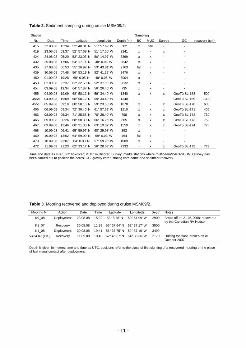
Table 2. Sediment sampling during cruise MSM09/2. Station Sampling
Nr. Date Time Latitude Longitude Depth (m) BC MUC Survey GC - recovery (cm)415 22.08.08 15:34 52° 40.01' N 51° 57.99' W 302 x fail - - 419 23.08.08 03:37 52° 57.69' N 51° 17.60' W 2241 x - x - 424 24.08.08 05:20 53° 23.03' N 50° 14.97' W 3369 x x - - 432 25.08.08 17:06 54° 17.14' N 48° 0.06' W 3842 x x - - 435 27.08.08 06:53 55° 26.92' N 53° 43.81' W 2763 fail - - - 439 30.08.08 07:48 56° 53.19' N 52° 41.38' W 3476 x x - - 450 01.09.08 19:28 60° 0.05' N 49° 0.06' W 3004 x - - - 453 02.09.08 22:37 62° 32.59' N 52° 37.93' W 2632 x x - - 454 03.09.08 19:34 64° 57.87' N 56° 26.40' W 735 x x - - 455 04.09.08 19:09 68° 58.12' N 59° 34.40' W 1340 x x x GeoTü SL-168 500
455b 04.09.08 19:09 68° 58.12' N 59° 34.40' W 1340 - - - GeoTü SL-169 1000 455c 05.09.08 09:10 68° 58.15' N 59° 23.58' W 1078 x - x GeoTü SL-170 600 456 06.09.08 09:34 72° 30.40' N 61° 57.32' W 1210 x x x GeoTü SL-171 405 463 08.09.08 05:34 71° 25.53' N 70° 26.40' W 798 x x x GeoTü SL-172 730 465 09.09.08 00:26 68° 50.30' N 66° 16.26' W 865 x x x GeoTü SL-173 750 467 09.09.08 13:46 68° 31.88' N 63° 19.82' W 1559 x x x GeoTü SL-174 773 468 10.09.08 06:41 65° 59.97' N 60° 29.98' W 393 x - - - 469 10.09.08 13:52 64° 59.99' N 59° 0.03' W 464 fail x - - 470 10.09.08 22:07 64° 0.00' N 57° 59.96' W 1009 x x - - 472 11.09.08 21:23 62° 33.17' N 56° 28.08' W 2333 - x x GeoTü SL-175 773
Time and date as UTC, BC: boxcorer; MUC: multicorer; Survey: marks stations where multibeam/PARASOUND survey has been carried out to position the cores; GC: gravity corer, stating core name and sediment recovery. Table 3. Mooring recovered and deployed during cruise MSM09/2.
Mooring Nr. Action Date Time Latitude Longitude Depth Notes K9_08 Deployment 23.08.08 15:02 53° 8.78' N 50° 51.99' W 2909 Broke off on 21.05.2008; recovered
by the Canadian RV Hudson K1_07 Recovery 30.08.08 11:38 56° 37.64' N 52° 37.17' W 3500 K1_08 Deployment 30.08.08 19:41 56° 37.75' N 52° 37.10' W 3499
V434-07 (CIS) Recovery 11.09.08 10:49 62° 46.57' N 54° 36.36' W 2179 Drifting top float, broken off in October 2007
Depth is given in meters, time and date as UTC, positions refer to the place of first sighting of a recovered mooring or the place of last visual contact after deployment.
- 12 -
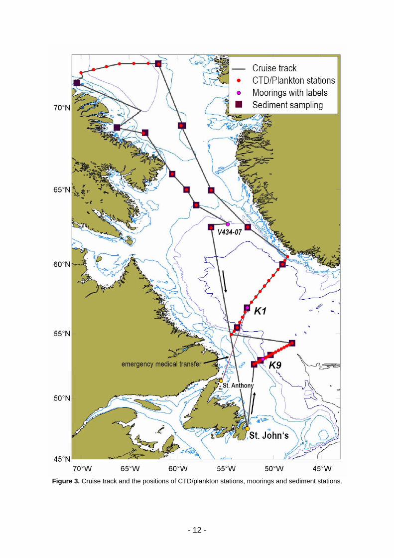
Figure 3. Cruise track and the positions of CTD/plankton stations, moorings and sediment stations.
- 13 -
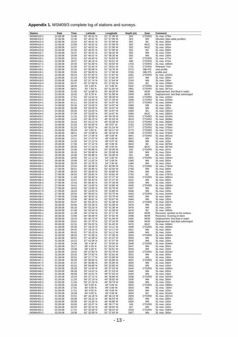
Appendix 1. MSM09/3 complete log of stations and surveys.
Station Date Time Latitude Longitude Depth (m) Gear Comment MSM9/415-1 22.08.08 12:06 52° 40.01' N 51° 57.99' W 302 CTD/RO SL max. 279m MSM9/415-2 22.08.08 12:36 52° 40.01' N 51° 57.99' W 303 MN Aborted; data cable problem MSM9/415-3 22.08.08 13:24 52° 40.01' N 51° 57.99' W 302 BC SL max. 300m MSM9/415-4 22.08.08 13:55 52° 40.01' N 51° 57.99' W 302 MUC SL max. 300m MSM9/415-5 22.08.08 14:57 52° 40.01' N 51° 57.99' W 302 MUC SL max. 305m MSM9/415-6 22.08.08 15:34 52° 40.01' N 51° 57.99' W 302 BC SL max. 300m MSM9/415-7 22.08.08 16:37 52° 40.01' N 51° 58.26' W 300 MN SL max. 220m MSM9/415-8 22.08.08 16:59 52° 40.01' N 51° 58.26' W 300 MN SL max. 100m MSM9/416-1 22.08.08 18:31 52° 46.45' N 51° 43.93' W 497 CTD/RO SL max. 477m MSM9/416-1 22.08.08 18:57 52° 46.19' N 51° 43.51' W 498 CTD/RO SL max. 470m MSM9/417-1 22.08.08 20:45 52° 52.48' N 51° 29.54' W 1703 CTD/RO SL max. 1684m MSM9/417-1 22.08.08 21:08 52° 52.45' N 51° 29.51' W 1701 CTD/RO Releaser Test MSM9/418-1 22.08.08 22:34 52° 58.08' N 51° 18.76' W 2274 MB+PS start profile MSM9/418-1 22.08.08 23:05 52° 58.00' N 51° 17.94' W 2255 MB+PS profile end MSM9/419-1 23.08.08 00:15 52° 57.92' N 51° 17.87' W 2261 CTD/RO SL max. 2222m MSM9/419-2 23.08.08 01:23 52° 57.89' N 51° 17.82' W 2247 MN SL max. 300m MSM9/419-3 23.08.08 01:49 52° 57.74' N 51° 17.64' W 2243 MN SL max. 100m MSM9/419-4 23.08.08 03:37 52° 57.69' N 51° 17.60' W 2241 BC SL max. 2256m MSM9/420-1 23.08.08 06:46 53° 3.39' N 51° 3.96' W 2632 CTD/RO SL max. 2594m MSM9/421-1 23.08.08 09:51 53° 7.93' N 50° 51.83' W 2891 CTD/RO SL max. 2871m MSM9/421-2 23.08.08 12:30 53° 10.68' N 50° 49.28' W 2989 MOR Deployement: first float in water MSM9/421-2 23.08.08 15:02 53° 8.78' N 50° 51.99' W 2909 MOR Deployement: last float submerged MSM9/422-1 23.08.08 17:51 53° 12.44' N 50° 39.39' W 3165 CTD/RO SL max. 3152m MSM9/423-1 23.08.08 20:51 53° 18.30' N 50° 27.28' W 3266 CTD/RO SL max. 3220m MSM9/424-1 24.08.08 01:11 53° 23.03' N 50° 14.97' W 3372 CTD/RO SL max. 3345m MSM9/424-2 24.08.08 02:45 53° 23.03' N 50° 14.97' W 3368 MN SL max. 300m MSM9/424-3 24.08.08 03:08 53° 23.03' N 50° 14.97' W 3369 MN SL max. 100m MSM9/424-4 24.08.08 05:20 53° 23.03' N 50° 14.97' W 3369 BC SL max. 3391m MSM9/424-5 24.08.08 07:59 53° 23.03' N 50° 14.97' W 3366 MUC SL max. 3382m MSM9/425-1 24.08.08 11:15 53° 29.58' N 49° 59.78' W 3534 CTD/RO SL max. 3519m MSM9/426-1 24.08.08 14:45 53° 36.23' N 49° 42.53' W 3619 CTD/RO SL max. 3608m MSM9/427-1 24.08.08 18:16 53° 43.11' N 49° 25.28' W 3713 CTD/RO SL max. 3683m MSM9/428-1 24.08.08 21:53 53° 50.00' N 49° 8.57' W 3752 CTD/RO SL max. 3739m MSM9/429-1 25.08.08 01:25 53° 56.67' N 48° 51.24' W 3777 CTD/RO SL max. 3765m MSM9/430-1 25.08.08 05:04 54° 3.55' N 48° 34.17' W 3773 CTD/RO SL max. 3772m MSM9/431-1 25.08.08 08:51 54° 10.08' N 48° 18.18' W 3788 CTD/RO SL max. 3763m MSM9/432-1 25.08.08 12:40 54° 17.05' N 48° 0.05' W 3841 CTD/RO SL max. 3831m MSM9/432-2 25.08.08 14:11 54° 17.07' N 48° 0.05' W 3841 MN SL max. 300m MSM9/432-3 25.08.08 14:30 54° 17.12' N 48° 0.07' W 3883 MN SL max. 100m MSM9/432-4 25.08.08 17:06 54° 17.14' N 48° 0.06' W 3842 BC SL max. 3876m MSM9/432-5 25.08.08 20:05 54° 17.14' N 48° 0.05' W 3845 MUC SL max. 3874m MSM9/433-1 26.08.08 15:46 54° 55.98' N 54° 20.09' W 320 CTD/RO SL max. 297m MSM9/433-2 26.08.08 16:20 54° 55.98' N 54° 20.08' W 320 MN SL max. 250m MSM9/433-3 26.08.08 16:38 54° 55.98' N 54° 20.08' W 321 MN SL max. 100m MSM9/434-1 26.08.08 18:55 55° 11.11' N 54° 3.00' W 1601 CTD/RO SL max. 1564m MSM9/434-2 26.08.08 19:58 55° 11.02' N 54° 2.69' W 1540 MN SL max. 300m MSM9/434-3 26.08.08 20:20 55° 10.76' N 54° 2.30' W 1484 MN SL max. 100m MSM9/435-1 26.08.08 23:24 55° 26.98' N 53° 43.96' W 2761 CTD/RO SL max. 2760m MSM9/435-2 27.08.08 00:31 55° 26.96' N 53° 43.92' W 2760 MN SL max. 300m MSM9/435-3 27.08.08 00:54 55° 26.94' N 53° 43.86' W 2760 MN SL max. 100m MSM9/435-4 27.08.08 06:53 55° 26.92' N 53° 43.81' W 2763 BC SL max. 2787m MSM9/436-1 27.08.08 11:49 55° 50.40' N 53° 27.27' W 3105 CTD/RO SL max. 3082m MSM9/436-2 27.08.08 12:57 55° 50.40' N 53° 27.27' W 3101 MN SL max. 300m MSM9/436-3 27.08.08 13:18 55° 50.40' N 53° 27.28' W 3100 MN SL max. 100m MSM9/437-1 27.08.08 16:41 56° 13.50' N 53° 10.80' W 3405 CTD/RO SL max. 3383m MSM9/437-2 27.08.08 18:03 56° 13.50' N 53° 10.79' W 3407 MN SL max. 300m MSM9/437-3 27.08.08 18:23 56° 13.50' N 53° 10.80' W 3406 MN SL max. 100m MSM9/438-1 27.08.08 20:43 56° 36.62' N 52° 53.75' W 3463 CTD/RO SL max. 3444m MSM9/438-2 27.08.08 23:08 56° 36.61' N 52° 53.79' W 3462 MN SL max. 300m MSM9/438-3 27.08.08 23:36 56° 36.61' N 52° 53.87' W 3464 MN SL max. 100m MSM9/439-1 30.08.08 03:47 56° 53.19' N 52° 41.38' W 3474 CTD/RO SL max. 3457m MSM9/439-2 30.08.08 04:56 56° 53.18' N 52° 41.38' W 3476 MN SL max. 300m MSM9/439-3 30.08.08 05:18 56° 53.18' N 52° 41.38' W 3476 MN SL max. 100m MSM9/439-4 30.08.08 07:48 56° 53.19' N 52° 41.38' W 3476 BC SL max. 3493m MSM9/440-1 30.08.08 11:38 56° 37.64' N 52° 37.17' W 3500 MOR Recovery: spotted on the surface MSM9/440-1 30.08.08 13:59 56° 39.49' N 52° 37.64' W 3498 MOR Recovery: mooring on deck MSM9/441-1 30.08.08 16:15 56° 40.73' N 52° 41.46' W 3492 MOR Deployement: first float in water MSM9/441-1 30.08.08 19:41 56° 37.75' N 52° 37.10' W 3499 MOR Deployement: last float submerged MSM9/442-1 30.08.08 22:31 56° 53.23' N 52° 41.40' W 3476 MUC SL max. 3494m MSM9/443-1 31.08.08 03:30 57° 18.15' N 52° 14.11' W 3499 CTD/RO SL max. 3493m MSM9/443-2 31.08.08 04:42 57° 18.15' N 52° 14.11' W 3501 MN SL max. 300m MSM9/443-3 31.08.08 05:02 57° 18.15' N 52° 14.11' W 3499 MN SL max. 100m MSM9/444-1 31.08.08 08:33 57° 41.09' N 51° 47.06' W 3503 CTD/RO SL max. 3494m MSM9/444-2 31.08.08 09:51 57° 41.09' N 51° 47.07' W 3503 MN SL max. 300m MSM9/444-3 31.08.08 10:13 57° 41.09' N 51° 47.07' W 3505 MN SL max. 100m MSM9/445-1 31.08.08 14:04 58° 4.36' N 51° 20.50' W 3548 CTD/RO SL max. 3546m MSM9/445-2 31.08.08 15:17 58° 4.35' N 51° 20.51' W 3547 MN SL max. 300m MSM9/445-3 31.08.08 15:38 58° 4.35' N 51° 20.51' W 3545 MN SL max. 100m MSM9/446-1 31.08.08 19:15 58° 27.84' N 50° 52.79' W 3533 CTD/RO SL max. 3523m MSM9/446-2 31.08.08 20:32 58° 27.82' N 50° 52.81' W 3531 MN SL max. 300m MSM9/446-3 31.08.08 20:52 58° 27.77' N 50° 52.89' W 3535 MN SL max. 100m MSM9/447-1 01.09.08 00:29 58° 50.84' N 50° 25.88' W 3501 CTD/RO SL max. 3489m MSM9/447-2 01.09.08 01:41 58° 50.86' N 50° 25.85' W 3502 MN SL max. 300m MSM9/447-3 01.09.08 02:01 58° 50.86' N 50° 25.85' W 3502 MN SL max. 100m MSM9/448-1 01.09.08 05:28 59° 14.00' N 49° 57.53' W 3444 CTD/RO SL max. 3430m MSM9/448-2 01.09.08 06:38 59° 14.01' N 49° 57.53' W 3445 MN SL max. 300m MSM9/448-3 01.09.08 06:58 59° 14.01' N 49° 57.53' W 3444 MN SL max. 100m MSM9/449-1 01.09.08 10:24 59° 37.13' N 49° 28.86' W 3336 CTD/RO SL max. 3325m MSM9/449-2 01.09.08 11:33 59° 37.14' N 49° 28.82' W 3335 MN SL max. 300m MSM9/449-3 01.09.08 11:54 59° 37.16' N 49° 28.73' W 3336 MN SL max. 100m MSM9/450-1 01.09.08 15:30 60° 0.03' N 49° 0.06' W 3002 CTD/RO SL max. 2985m MSM9/450-2 01.09.08 17:02 60° 0.05' N 49° 0.06' W 3003 MN SL max. 300m MSM9/450-3 01.09.08 17:21 60° 0.05' N 49° 0.06' W 3002 MN SL max. 100m MSM9/450-4 01.09.08 19:28 60° 0.05' N 49° 0.06' W 3004 BC SL max. 3016m MSM9/451-1 01.09.08 23:31 60° 16.18' N 48° 46.13' W 2829 CTD/RO SL max. 2821m MSM9/451-2 02.09.08 00:38 60° 16.22' N 48° 46.53' W 2831 MN SL max. 300m MSM9/451-3 02.09.08 00:59 60° 16.26' N 48° 46.86' W 2834 MN SL max. 100m MSM9/452-1 02.09.08 03:03 60° 32.07' N 48° 28.77' W 165 CTD/RO SL max. 140m MSM9/452-2 02.09.08 03:20 60° 32.10' N 48° 28.92' W 167 MN SL max. 100m MSM9/453-1 02.09.08 17:41 62° 32.58' N 52° 38.44' W 2618 CTD/RO SL max. 2584m MSM9/453-2 02.09.08 18:38 62° 32.59' N 52° 37.93' W 2627 MN SL max. 300m

- 14 -
Appendix 1 (continued). MSM09/3 complete log of stations and surveys.
Station Date Time Latitude Longitude Depth (m) Gear Comment MSM9/453-3 02.09.08 18:58 62° 32.59' N 52° 37.93' W 2629 MN SL max. 100m MSM9/453-4 02.09.08 19:17 62° 32.59' N 52° 37.93' W 2630 MN SL max. 300m MSM9/453-5 02.09.08 19:36 62° 32.59' N 52° 37.93' W 2631 MN SL max. 100m MSM9/453-6 02.09.08 22:37 62° 32.59' N 52° 37.93' W 2632 BC SL max. 2641m MSM9/453-7 03.09.08 00:43 62° 32.59' N 52° 37.93' W 2634 MUC SL max. 2641 m MSM9/454-1 03.09.08 17:16 64° 57.87' N 56° 26.39' W 736 CTD/RO SL max. 712m MSM9/454-2 03.09.08 17:48 64° 57.87' N 56° 26.40' W 735 MN SL max. 300m MSM9/454-3 03.09.08 18:10 64° 57.87' N 56° 26.40' W 735 MN SL max. 100m MSM9/454-4 03.09.08 18:34 64° 57.87' N 56° 26.40' W 735 MN SL max. 300m MSM9/454-5 03.09.08 18:56 64° 57.87' N 56° 26.39' W 735 MN SL max. 100m MSM9/454-6 03.09.08 19:34 64° 57.87' N 56° 26.40' W 735 BC SL max. 738m MSM9/454-7 03.09.08 20:19 64° 57.87' N 56° 26.40' W 735 MUC SL max. 738m MSM9/455-1 04.09.08 17:49 68° 58.12' N 59° 34.38' W 1350 CTD/RO SL max. 1318m MSM9/455-2 04.09.08 19:09 68° 58.12' N 59° 34.40' W 1340 BC SL max. 1346m MSM9/455-3 04.09.08 20:28 68° 58.12' N 59° 34.39' W 1339 MUC SL max. 1343m MSM9/455-4 04.09.08 21:49 68° 58.12' N 59° 34.39' W 1342 GC SL max. 1351m MSM9/455-5 04.09.08 23:43 68° 58.12' N 59° 34.39' W 1341 GC SL max. 1360m MSM9/455-6 05.09.08 00:44 68° 58.14' N 59° 29.09' W 1249 MB+PS start profile MSM9/455-6 05.09.08 04:57 69° 1.46' N 59° 8.97' W 705 MB+PS profile end MSM9/455-7 05.09.08 06:08 68° 58.15' N 59° 23.60' W 1088 MN SL max. 300m MSM9/455-8 05.09.08 06:35 68° 58.20' N 59° 23.67' W 1108 MN SL max. 300m MSM9/455-9 05.09.08 06:55 68° 58.25' N 59° 23.77' W 1085 MN SL max. 100m MSM9/455-10 05.09.08 07:07 68° 58.26' N 59° 23.79' W 1093 MN SL max. 100m MSM9/455-11 05.09.08 08:00 68° 58.15' N 59° 23.58' W 1088 BC SL max. 1094m MSM9/455-12 05.09.08 09:10 68° 58.15' N 59° 23.58' W 1078 BC SL max. 1091m MSM9/455-13 05.09.08 10:13 68° 58.15' N 59° 23.58' W 1091 GC SL max. 1114m MSM9/456-1 06.09.08 04:28 72° 28.61' N 61° 54.62' W 1172 CTD/RO SL max. 1158m MSM9/456-2 06.09.08 05:06 72° 28.60' N 61° 54.70' W 1174 MN SL max. 300m MSM9/456-3 06.09.08 05:25 72° 28.60' N 61° 54.69' W 1177 MN SL max. 100m MSM9/456-4 06.09.08 05:34 72° 28.60' N 61° 54.69' W 1176 MB+PS start profile MSM9/456-4 06.09.08 08:42 72° 30.36' N 61° 57.33' W 1217 MB+PS profile end MSM9/456-5 06.09.08 09:34 72° 30.40' N 61° 57.32' W 1210 BC SL max. 1216m MSM9/456-6 06.09.08 10:39 72° 30.38' N 61° 57.35' W 1215 MUC SL max. 1216m MSM9/456-7 06.09.08 11:41 72° 30.40' N 61° 57.31' W 1210 GC SL max. 1226m MSM9/457-1 06.09.08 14:23 72° 31.33' N 63° 0.00' W 2128 CTD/RO SL max. 1511m MSM9/457-2 06.09.08 15:03 72° 31.33' N 63° 0.00' W 2130 MN SL max. 300m MSM9/457-3 06.09.08 15:25 72° 31.33' N 63° 0.00' W 2127 MN SL max. 100m MSM9/458-1 06.09.08 18:12 72° 30.94' N 64° 30.24' W 2300 CTD/RO SL max. 1500m MSM9/458-2 07.09.08 01:49 72° 31.02' N 64° 30.04' W 2306 MN SL amx. 300m MSM9/458-3 07.09.08 02:09 72° 31.02' N 64° 30.04' W 2300 MN SL max. 100m MSM9/459-1 07.09.08 05:12 72° 29.98' N 65° 59.93' W 2364 CTD/RO SL max. 2332m MSM9/459-2 07.09.08 06:07 72° 29.97' N 66° 0.00' W 2363 MN SL max. 300m MSM9/459-3 07.09.08 06:29 72° 29.97' N 66° 0.16' W 2364 MN SL max. 100m MSM9/460-1 07.09.08 09:27 72° 20.57' N 67° 21.41' W 2367 CTD/RO SL max. 1504m MSM9/460-2 07.09.08 10:15 72° 20.57' N 67° 21.41' W 2368 MN SL max. 300m MSM9/460-3 07.09.08 10:37 72° 20.57' N 67° 21.41' W 2368 MN SL max. 100m MSM9/461-1 07.09.08 13:36 72° 10.53' N 68° 41.36' W 2166 CTD/RO SL max. 1500m MSM9/461-2 07.09.08 14:18 72° 10.50' N 68° 41.30' W 2167 MN SL max. 300m MSM9/461-3 07.09.08 14:40 72° 10.44' N 68° 41.11' W 2166 MN SL max. 100m MSM9/462-1 07.09.08 17:27 72° 0.00' N 69° 59.96' W 1795 CTD/RO SL max. 1767m MSM9/462-2 07.09.08 18:12 72° 0.00' N 69° 59.96' W 1795 MN SL max. 300m MSM9/462-3 07.09.08 18:31 72° 0.00' N 69° 59.96' W 1788 MN SL max. 100m MSM9/463-1 07.09.08 19:48 71° 45.71' N 69° 49.96' W 1477 MB+PS start profile MSM9/463-1 08.09.08 04:53 71° 25.44' N 70° 25.71' W 798 MB+PS profile end MSM9/463-2 08.09.08 05:34 71° 25.53' N 70° 26.40' W 798 BC SL max. 804m MSM9/463-3 08.09.08 06:21 71° 25.53' N 70° 26.40' W 798 MUC SL max. 799m MSM9/463-4 08.09.08 07:14 71° 25.53' N 70° 26.40' W 793 GC SL max. 805m MSM9/464-1 08.09.08 23:09 68° 51.01' N 66° 11.43' W 864 MB+PS start profile MSM9/464-1 08.09.08 23:35 68° 50.24' N 66° 16.35' W 872 MB+PS profile end MSM9/465-1 09.09.08 00:26 68° 50.30' N 66° 16.26' W 865 BC SL max. 850m MSM9/465-2 09.09.08 01:16 68° 50.30' N 66° 16.26' W 865 MUC SL max. 865m MSM9/465-3 09.09.08 02:19 68° 50.29' N 66° 16.26' W 872 GC SL max. 877m MSM9/466-1 09.09.08 08:47 68° 30.00' N 63° 29.96' W 1474 CTD/RO SL max. 1447m MSM9/466-2 09.09.08 09:30 68° 30.01' N 63° 30.00' W 1469 MN SL max. 300m MSM9/466-3 09.09.08 09:50 68° 30.01' N 63° 30.00' W 1468 MN SL max. 100m MSM9/466-4 09.09.08 10:00 68° 30.01' N 63° 29.98' W 1473 MB+PS start profile MSM9/466-4 09.09.08 12:04 68° 34.97' N 63° 6.12' W 1663 MB+PS profile end MSM9/467-1 09.09.08 13:46 68° 31.88' N 63° 19.82' W 1559 BC SL max. 1561m MSM9/467-2 09.09.08 15:03 68° 31.88' N 63° 19.83' W 1550 MUC SL max. 1559m MSM9/467-3 09.09.08 16:13 68° 31.87' N 63° 19.83' W 1551 GC SL max. 1566m MSM9/468-1 10.09.08 05:29 65° 59.97' N 60° 29.98' W 389 CTD/RO SL max. 369m MSM9/468-2 10.09.08 05:54 65° 59.97' N 60° 29.98' W 389 MN SL max. 300m MSM9/468-3 10.09.08 06:14 65° 59.97' N 60° 29.98' W 391 MN SL max. 100m MSM9/468-4 10.09.08 06:41 65° 59.97' N 60° 29.98' W 393 BC SL max. 404m MSM9/469-1 10.09.08 12:25 65° 0.01' N 59° 0.08' W 464 CTD/RO SL max. 444m MSM9/469-2 10.09.08 12:52 65° 0.00' N 59° 0.06' W 465 MN SL max. 300m MSM9/469-3 10.09.08 13:15 64° 59.99' N 59° 0.03' W 465 MN SL max. 100m MSM9/469-4 10.09.08 13:52 64° 59.99' N 59° 0.03' W 464 BC SL max. 475 m MSM9/469-5 10.09.08 14:29 64° 59.99' N 59° 0.03' W 466 BC SL max. 474m MSM9/469-6 10.09.08 15:05 64° 59.99' N 59° 0.03' W 466 MUC SL max. 470m MSM9/470-1 10.09.08 20:29 64° 0.00' N 57° 59.96' W 1010 CTD/RO SL max. 998m MSM9/470-2 10.09.08 21:04 64° 0.00' N 57° 59.96' W 1009 MN SL max. 300m MSM9/470-3 10.09.08 21:24 64° 0.00' N 57° 59.96' W 1010 MN SL max. 100m MSM9/470-4 10.09.08 22:07 64° 0.00' N 57° 59.96' W 1009 BC SL max. 1027m MSM9/470-5 10.09.08 23:13 64° 0.00' N 57° 59.96' W 1009 MUC SL max. 1022m MSM9/471-1 11.09.08 10:49 62° 46.57' N 54° 36.36' W 2179 MOR Recovery: mooring spotted on surface MSM9/471-1 11.09.08 11:08 62° 47.41' N 54° 35.17' W 2098 MOR Recovery: mooring on deck MSM9/472-1 11.09.08 14:55 62° 42.22' N 56° 28.80' W 2474 MB+PS start profile MSM9/472-1 11.09.08 18:52 62° 33.18' N 56° 28.10' W 2332 MB+PS profile end MSM9/472-2 11.09.08 19:44 62° 33.17' N 56° 28.08' W 2330 MUC SL max. 2339m MSM9/472-3 11.09.08 21:23 62° 33.17' N 56° 28.08' W 2333 GC SL max. 2358m MSM9/472-4 11.09.08 22:56 62° 29.84' N 56° 27.20' W 2138 MN SL max. 300m MSM9/472-5 11.09.08 23:15 62° 29.84' N 56° 27.20' W 2136 MN SL max. 100m MSM9/472-6 12.09.08 00:18 62° 29.83' N 56° 27.26' W 2119 CTD/RO SL max. 2098m
Positions refer to gear at maximum depth (SL max.), time and date as UTC. Gear abbreviations: BC boxcorer, CTD/RO conductivity, temperature and depth device combined with a rosette; GC gravity corer; MB+PS multibeam and PARASOUND systems, MSN multiple opening-closing plankton net; MOR mooring, MUC multicorer.