safeguarding project of hassan fathy’s new gourna...
TRANSCRIPT
6-Master Plan Final Reportprepared by Daniele Pini, January 2011
Safeguarding project of Hassan Fathy’s New Gourna Village A UNESCO Initiative
in partnership with
Luxor Governorate
DOCUMENTATION:

Management of World Heritage sites in Egypt
SAFEGUARDING OF HASSAN FATHY’S NEW GOURNA VILLAGE
Master Plan Final Report
Prepared by:
Daniele Pini, consultant
Ferrara, 15.01.2011

Content
Terms of Reference .............................................................................................................................. v
1. Introduction ...................................................................................................................................... 1
1.1. New Gourna, the Hassan Fathy’s masterpiece ...................................................................... 1
1.2. The Safeguarding Initiatives ................................................................................................. 1
1.3. The Safeguarding project’s components ............................................................................... 3
1.4. Preparatory activities ............................................................................................................. 3
2. The Safeguarding Project objectives ............................................................................................ 7
2.1. The Project’s Objectives ....................................................................................................... 7
2.2. The Master Plan’s objectives ................................................................................................ 8
2.3. The Study Area ...................................................................................................................... 9
3. Findings from the Preliminary studies ....................................................................................... 12
3.1. The documentation on Hassan Fathy’s work in New Gourna............................................. 12
3.2. The Hassan Fathy’s concept for New Gourna..................................................................... 12
3.3. The implementation of the Hassan Fathy’s original project ............................................... 16
3.4. The physical survey ............................................................................................................. 18
3.5. The Heritage of Hassan Fathy’s work ................................................................................. 24
3.6. The socio-economic condition ............................................................................................ 28
3.7. Critical issues ...................................................................................................................... 29
Planning ..................................................................................................................................... 29
Public Buildings ......................................................................................................................... 29
Housing ...................................................................................................................................... 30
Public Spaces & Infrastructure .................................................................................................. 31

4. The Master Plan proposals ......................................................................................................... 32
4.1. The objectives...................................................................................................................... 32
4.2. The proposed planning strategy .......................................................................................... 33
4.3. Protection measures ............................................................................................................. 34
4.4. Conservation and Land Use measures................................................................................. 34
4.5. The Conservation Area ........................................................................................................ 37
Preservation and rehabilitation of the original village fabric and layout ................................... 37
Restoration and adaptive reuse of Hassan Fathy’s public buildings and houses. ...................... 38
Housing rehabilitation ................................................................................................................ 38
4.6. The “rest of the Core Area” ................................................................................................. 39
Spatial layout.............................................................................................................................. 39
Reorganisation and rehabilitation of the existing services and public facilities ........................ 39
The creation of the ICSA ........................................................................................................... 40
New Housing development ........................................................................................................ 40
Eco - Tourism development ....................................................................................................... 40
5. The implementation of the Master Plan ..................................................................................... 42
5.1. Emergency and priority actions ........................................................................................... 42
Emergency actions ..................................................................................................................... 42
Priority actions ........................................................................................................................... 42
5.2. Long term conservation activities ....................................................................................... 43
Surveys and documentation ....................................................................................................... 43
Development planning and action projects ................................................................................ 43
Housing policy development ..................................................................................................... 43
Overall improvement of urban infrastructure and public spaces ............................................... 45
Annexes .............................................................................................................................................. 46
1. List of participants to the 1st Scientific Committee Meeting, Luxor 2-3 October 2010 ..... 47

2. Project Road Map proposed by the 1st Scientific Committee Meeting, Luxor 2-3 October 2010 48
3. The Hassan Fathy International Centre for Sustainable Architecture. UNESCO preliminary ideas 50
Terms of Reference
The present report refers to the following Terms of Reference, as stated by art. 1, par. D of the contract no. 4500094983, Amendment No.2 of 19.07.2010:
“In addition to your current assignments, this is to request your expertise within the programme Management of World Heritage sites in Egypt for the project "Safeguarding of Hassan Fathy's New Gourna village".
In order to reflect these changes, the above-mentioned contract, established between UNESCO and yourself, is amended as follows:
……
D. Within the programme Management of World Heritage sites in Egypt, in close consultation with the World Heritage Centre and the responsible national authorities, and on the basis of the approved project documents, the Contractor shall coordinate and supervise the implementation of the programme. In particular, according to the project proposal for the Safeguarding of Hassan Fathy's New Gourna village, the Contractor shall:
1. Visit the site to follow-up the on-going activities and meet with local authorities to discuss the goals and objectives of the project;
2. Supervise the physical survey of the village, carried out by a team of surveyors selected by the World Heritage Centre, giving advice on the methodology and assessing the results;
3. Outline a draft Master Plan for the conservation, rehabilitation and development of New Gourna to be submitted to the World Heritage Centre no later than 01 October 201 0;
4. Participate in meetings of the Scientific Committee of the project and to the conception of the "Hassan Fathy Centre for Sustainable Architecture";
5. Submit a final Master Plan for the village, the outline of an operational strategy for the implementation of the project and a work plan for its implementation.”

1
1. INTRODUCTION
1.1. New Gourna, the Hassan Fathy’s masterpiece
The Village of New Gourna was designed and built by Hassan Fathy (1900-1989) between 1946 and 1952. It was created to shelter the community of Old Gourna (Gournii) who had lived above the tombs in the ancient cemetery of Thebes and whose relocation was considered as a solution to reduce the damages to the Pharaonic Tombs.
The main characteristics of the Village consist of its reinterpretation of a traditional urban and architectural setting, its appropriate use of local materials and techniques, as well as its extraordinary sensitivity to climatic problems. It demonstrated, within the era of “modern movement” that sustainability and social cohesion could also be met with vernacular architectures, local materials and techniques. For this reason, it is an outstanding example of sustainable human settlement and appropriate use of technology in architecture and planning.
The Hassan Fathy’s book dedicated to the New Gourna experience is one of the major architecture and planning references. First published in Cairo in 1969 under the title “Gourna, A tale of two cities”, was then published in France as “Construire avec le people” (1970), and later in USA with the title “Architecture for the Poor: An Experiment in Rural Egypt” (1973). It became a source of inspiration for a new generation of architects and planners worldwide calling for an integration of vernacular technology with modern architectural principles.
The book covers of the French and USA editions of the Hassan Fathy’s book and the famous original plan of the village
1.2. The Safeguarding Initiatives
Although New Gourna is situated inside the boundary of the World Heritage Property of Ancient Thebes with its Necropolis (inscribed in 1979 on the World Heritage List), its outstanding value was not recognised in the nomination dossier at the moment of its preparation.
Since 2008, the World Heritage Committee has invited the Government of Egypt “to strengthen efforts to restore Hassan Fathy’s New Gourna Village”1 and, as a follow up, a joint
1 See Decision 32 COM 7B.57, at the 32nd session (Quebec City, 2008).

2
UNESCO/ICOMOS monitoring mission in May 20092, reiterated the need for urgent measures to safeguard the outstanding architectural value of New Gourna. Soon after the Prime Ministry’s Decree n. 3/09/06/3 declared Hassan Fathy’s Village as a “Heritage Protectorate” and created a Committee with members from the Ministry of Culture, Supreme Council for Antiquities, the National Organization for Urban Harmony (NOUH) and Luxor Governorate to identify the perimeters of the village and the legal measures for the protection of the area “as an antiquity or as a distinctive urban style”.
In the meantime, the Mediterra Conference on Earthen Architecture organized by University of Cagliari (Italy), had addressed to UNESCO a petition of the Association “Save the Heritage of Hassan Fathy” expressing their concerns and recommending measures for the safeguard. Several threats were pointed out, which led also the World Monuments Fund to inscribe the village on the 2010 World Monuments Watch List for the 100 most endangered sites in the world.
To support the Egyptian authorities, the WHC has launched in October 2009 the initiative Safeguarding project of Hassan Fathy’s New Gourna Village in partnership with the Governorate of Luxor, the Ministry of Culture, and other international organisations, within the framework of the World Heritage Centre Earthen Architecture Programme (WHEAP)3, under of the phase 2 (2009-2011), which focuses on Africa and Arab States.
UNESCO consulted other international organisations to collaborate in the development in the Project initiative. In particular, the World Monuments Fund (WMF) expressed its interest in participating to the initiative and made a proposal for its preservation and protection through international cooperation in the form of a matching fund project. In the initial phase, the WMF is supporting the socio-economic survey.
Consultations were held to address possible partnership and strategies for the development of the project with the associations “Save the Heritage of Hassan Fathy” and CRAterre-ENSA that presented a study on the state of conservation of New Gourna undertaken in partnership, summarising the threats and degradation facing the village. Both associations have confirmed their interest to support the UNESCO Project initiative and stressed the importance of a detailed physical survey. Also the General Manager and the Director of the Aga Khan Trust for Culture expressed great interest in supporting the project initiative as Hassan Fathy is among the founders of the Aga Khan architectural programmes.
2 See D. Repellin, D. Pini, F. Miglioli: Ancient Thebes with its necropolis. Joint UNESCO/ICOMOS monitoring mission 8 – 11 May 2009.
3 This programme, adopted in 2007, is implemented in partnership with CRAterre-ENSAG, ICOMOS, ICCROM, the Ecole du Patrimoine Africain in Benin (EPA, School of African Heritage), the Center For Heritage Development In Africa (CHDA), Kenya and the Centre de Conservation et de Réhabilitation du Patrimoine Architectural des Zones Atlasiques et Subatlasiques (CERKAS, Centre for Conservation and Restoration of Atlas and Subatlas Architectural Heritage), Morocco, and intends to improve the management and conservation of earthen architecture properties protected under the World Heritage Convention as an important tool for sustainable development and an opportunity to develop sustainable forms of tourist accommodation.

3
1.3. The Safeguarding project’s components
The components of the UNESCO WHC Initiative “Safeguarding Project of Hassan Fathy’s New Gourna Village” were defined as follows in October 2009:
1) Emergency actions, to structurally consolidate major buildings of the Village (the Khan, the Theatre, and Hassan Fathy’s houses) as recommended by the report of a joint UNESCO/ICOMOS mission in May 2009, the World Monuments Fund and the Save the Heritage of Hassan Fathy.
2) Conservation Activities, including:
a) Survey and documentation of the New Gourna Village, to allow a thoroughly understanding of the current state of conservation and identify priority areas of action. This had to be coupled with an archives and documentation study intended to gather valuable data to trace the Village’s evolution since its construction;
b) Urban and Architectural Conservation Project for Community development, to address all relevant aspects such as urban planning, consolidation and conservation, adaptive re-use, local development, socio-economic aspects, infrastructure rehabilitation, aimed at supporting local development and creating new jobs in the fields of conservation and cultural tourism linked to Ancient Thebes and its Necropolis, and to the discovery of Hassan Fathy’s work;
c) Conservation and adaptive re-use of major buildings of the Village, such as the Khan, the Theatre and Hassan Fathy’s houses, to be implemented as pilot examples of good practice, bringing the attention on the great potential of the New Gourna Village to encourage similar initiatives by different actors;
d) Conservation Centre for the Study and Research on Earthen Architecture, to develop and disseminate best practices in the field of earthen architecture conservation in the Arab States Region, constituting a pole of exchange between scientific institutions (public and private), universities, professionals, civil society members and concerned authorities and communities.
1.4. Preparatory activities
Following these initiatives, several missions and preparatory activities carried out in 2010:
1) UNESCO Mission, March 9-14, 2010: the purpose was to discuss with the local authorities the modalities of implementation for the project ‘Safeguarding project of Hassan Fathy’s New Gourna village’ under the programme “Management of World Heritage sites in Egypt”. The Governorate of Luxor is identified as the institutional partner in the project implementation. Ms Franca Miglioli, UNESCO-WHC and Mr Daniele Pini, consultant, met with the Governor of Luxor who provided first documentation on New Gourna and offered logistical support to the initiative.
2) UNESCO Workshop, April 19-21, 2010: the aim was to undertake initial observations to identify concepts and priority actions required for the preparation of a conservation, rehabilitation and development plan. The group of experts invited included Mr Mauro Bertagnin, Ms Pamela Jerome, Mr Ahmed Hamid, the UNESCO consultants Ms Dalia Nabil and Mr Daniele Pini and the WMF representatives Ms Gina Haney and Mr Heba Mohamed Hosny. The following first actions were recommended in regards of the preparation of the work plan:

4
a) Research:
• Overall survey on the state of conservation and occupancy of the Hassan Fathy’s village; • Land-use situation in the surroundings; • Documentation survey and literature search on New Gourna and Hassan Fathy; • Socio-economic study to analyse socio-economic conditions and demographics;
b) Actors and Significance:
• Stakeholder “mapping” to identify key players and institutions, to clarify their associated interests/stakes in the project, and to establish liaisons/representatives to the planning team;
• Significance assessment to fully elucidate the full range of values associated with New Gourna and to map the features that demonstrate those values.
c) Areas definitions:
• Definition of perimeters of the study areas as well as areas for development of public facilities, sustainable tourism structures, possible residential extension to the north, possible areas for agriculture, transport and parking facilities etc.
d) Intervention Assessments:
• The definition of the types of intervention (i.e. maintenance and/or reuse, restoration, rehabilitation/demolition and reconstruction, demolition);
• The need for infrastructure upgrade and management; • The identification of the interventions for the revitalisation of the community core (i.e. the
relocation and/or upgrading of the school, the adaptive reuse of the Khan, the restoration of the theatre, and others);
• Careful assessment of feasibility and areas for possible highly sensitive project outcomes and components such as the demolition of infill structures, construction/reconstruction of Fathy’s original design for the whole village, the potential relocation of some residents, the designation of a tourist development area, developing a training centre for sustainable architecture, and more.
e) Jurisdiction
• Ownership and legal jurisdiction review to determine site boundaries, property owners, agencies with authority over the village, and building regulations;
• The study of the most appropriate forms of housing tenure (rental, property) for the concerned households, to be applied in conjunction with the different interventions of maintenance, rehabilitation, reconstruction or new construction;
• The proposal of a planning and building regulation to be implemented through all the different types of intervention.
f) Education
• The provision of an area for the international centre for sustainable architecture, to be tightly related to the proposals for the revitalisation of the community core. This should be

5
considered as a main driver for both the rehabilitation and the local sustainable socioeconomic development of New Gourna. To this regard a project outline of the centre is needed in order to evaluate the space requirement for the various activities that would be developed.
3) UNESCO Mission April 30-May 1, 2010: it was planned to follow up on the first results of the previous. Mr Francesco Bandarin, Director of the World Heritage Centre and Ms Franca Miglioli, UNESCO-WHC met with the Prime Minister of Egypt, the Minister of Culture and the Governor of Luxor for further discussion. It has been agreed that an outlined proposal should be prepared to launch the first tangible interventions during autumn. An official agreement on a defined plan of operations will be established between UNESCO and the Governorate specifying the obligations of both parties in the implementation of the activities prior to the launch of the activities.
4) The Physical Survey of the village of New Gourna, launched on July 13 by a UNESCO team under the supervision of Mr Daniele Pini, UNESCO consultant, to start the preparation of the draft of the Master Plan. A preliminary phase of preparation was concluded on 31 July 2010, the field survey on 15 August 2010 and the preparation of the GIS maps and the summary report on 30 September 2010, to serve as a fundamental information platform for the first International Scientific Committee meeting (see below). The physical survey was aimed at identifying the planning and conservation area, creating a reliable digitised base map to be transferred into a GIS system linked to a database. A plot-by-plot assessment of the building stock was carried out, producing a set of GIS maps and providing a summary report containing a preliminary analysis of the data. A number of investigations were carried out at the scale of the entire settlement for data related to complete systems, such as infrastructure networks and public open areas and green spaces. More detailed investigations were carried out on the individual plots, concerning housing typologies. The Governor of Luxor offered logistical support for the survey. The findings of the Survey represent the fundamental information platform for the Master Plan presented in this report4.
5) A research on documentation was conducted by a local researcher, from the 15th August until the beginning of November5. It was particularly aimed at identifying the existing sources of materials documenting the work of Hassan Fathy in New Gourna since the initial planning and design phase, through the different phases of the implementation.
6) A socio-economic survey was undertaken from 14 September to the first week of October by a team set-up by the World Monuments Fund. This survey aims to gather social and economic data on the people living in New Gourna, including information about household sizes, employment, tenure, occupancy, in- and out-migration, schooling and access to services. The socio-economic team has utilised, as a basis for the interviews, a survey form defined in collaboration with the physical survey team, for incorporation of data in the GIS system. The results of the physical survey and the preliminary results of the socio-economic survey have been presented at the first International Scientific Committee meeting (see below).
4 See “Safeguarding of Hassan Fathy’s New Gourna Village. Physical Survey Findings. Final Report”, October 2010, prepared by Nevine Aki and Mahmoud Qutb.
5 See “Final Report on Documentation research”, November 2010 prepared by Dalia Nabil Aly Abdul-Ghany

6
7) The 1st Scientific Committee Meeting, organised by UNESCO and the Governorate of Luxor on October 2 and 3, 2010: it was aimed at gathering international expertise, to receive advice and guidance for the development of the project implementation strategy, defining objectives and priority activities for the safeguarding of New Gourna Village. On that occasion, the physical survey and a draft Master Plan were presented by the UNESCO – WHC team. The issues raised by the debate have been summarised as follows6:
• The philosophy of the project should continue with Hassan Fathy’s legacy of addressing the community issues as a top priority on socio-cultural, socio-economic levels. Hassan Fathy’s interest in agricultural and local handicrafts development should also be the focus of the project’s approach;
• Emergency interventions should start immediately to save the endangered buildings from collapsing.
• Legal study of ownership/tenure issues should be carried out as soon as possible to set the legal framework within which the project can operate efficiently.
• Workshops with representatives from the city planning and local council should be organized to find solutions for controlling the situation in the village and for ensuring their collaboration in the village rehabilitation and management process.
• The geo-hydraulic studies must be undertaken to find solutions for the increase in water table.
• Initiating ICSA activities should be starting at the earliest stage of the project for managing the building consolidation and restoration/rehabilitation of pilot projects in the village.
• Tourism development should be marginalized and controlled, and it must not be allowed to cause pressure on the urban development of New Gourna or on the nature of the community.
A “Project road map” 7 was agreed by the participants that focuses on the Philosophy of the Project, and makes proposals for:
• Short term actions (first year): Knowledge of the current situation, Finalization of the Master Plan, Emergency stabilization, Listing of the buildings of Hassan Fathy, ICSA, Participation and Communication Strategy,
• Mid-term (1-3 years): Architectural Design of ICSA, Rehabilitation of the residential blocks designed by Hassan Fathy, Construction of ICSA, Design of other elements, Implementation of environmental remedial action, Sewage and other network and infrastructural systems
6 See “Report on First Scientific committee Meeting. Egypt, Luxor, 2-3 October 2010”, prepared by Dalia Nabil Aly Abdul-Ghany
7 The list of participants and the main outcomes of the First Scientific Committee Meeting are presented in Annex 1 and 2.

7
2. THE SAFEGUARDING PROJECT OBJECTIVES
2.1. The Project’s Objectives
One of the fundamental goals of the proposed UNESCO initiative is to valorise the pioneering ideas and philosophy of Hassan Fathy’s work and to reinforce its relevance to contemporary sustainability concerns. Fathy’s tenets derived from humanistic values about the connections between people and places and the use of traditional knowledge and materials especially the exceptional advantages of earth as full-fledged construction material. New Gourna was a critical experiment in the implementation of that philosophy. Thus, the safeguarding of New Gourna is about more than just preserving its original design and fabric, but is also about promotion, communication and education.
Another important project focus lays on restoration and management concerns. The alteration and destruction of original structures and features are on-going. The degraded state of conservation of New Gourna becomes evident through the destruction and collapse of major buildings due to lack of maintenance. Urgent restoration measures are needed to stop irreversible changes and loss. The number of original mud brick houses in Hassan Fathy’s Gourna is considerably reduced. The few public buildings such as the Khan and the market are in danger of collapse and the remaining open spaces are more and more encroached. The lack of infrastructure and maintenance of public facilities thus constitutes an important threat to the village as well as the on-going very intense construction activity with reinforced concrete pillars in inconsistent out-of-scale buildings.
In the preparation of the 1st Scientific Meeting, the expected results of the Project initiative were set as follows8:
• New Gourna Village’s state of conservation improved with realisation of pilot projects of restoration;
• Master Plan for conservation, rehabilitation and development defined and launched; • Regional and international promotion of Hassan Fathy’s work as a symbol of sustainable
architecture per se enhanced; • International Centre for Sustainable Architecture, dedicated to Hassan Fathy, as a world
training and research institute for sustainable architecture created; • Regional and international awareness of earthen architectural heritage increased; • Capacity of local actors in management and conservation of earthen architecture enhanced; • A network of experts and institutions in the study, conservation and dissemination of
sustainable architecture established.
8 See UNESCO – WHC: “Safeguarding project of Hassan Fathy’s New Gourna Village. A UNESCO Initiative”, First Scientific Committee meeting, Luxor, Egypt 2-3 October 2010

8
2.2. The Master Plan’s objectives
In this framework the Master Plan is intended as a tool to preserve and valorise the Hassan Fathy’s intellectual and physical heritage that still finds its expression in the New Gourna Village, particularly his pioneering planning and architectural ideas.
It aims at defining the spatial framework for the implementation of these different actions proposed by the 1st Scientific Committee for the short and mid-term, to be carried out through specific and detailed conservation and development projects, under the supervision and the technical coordination of the ICSA.
At the same time it provides proposals for a longer term perspective that takes into account the possible development of the village, to be implemented according to the Hassan Fathy’s planning principles, responding to the housing needs and the opportunities eventually created by the conservation and rehabilitation interventions to be undertaken in the short and mid-term.
To this purpose, it considers the creation of the International Centre for Sustainable Architecture (ICSA) proposed by UNESCO and the World Monument Fund as a fundamental option, which could make the village a field of experience to develop and disseminate “good practices”, whilst becoming the “brand location” for the ICSA itself.
Based on the documentation researches and the physical surveys carried out, the Master Plan’s objective is to define appropriate conservation and land-use measures to develop the following interrelated actions:
• The preservation and valorisation of the Hassan Fathy’s Heritage - not only the few building remaining intact but also the village concept, i.e. the urban layout and the spatial texture of the residential blocks which are still preserved to some extent;
• The rehabilitation of the residential blocks and the improvement of the housing conditions; • The revitalisation of the village, with the strengthening of the community core and the
upgrading of the public spaces and facilities; • The development of the village, both physical and socio-economic, to: a) resettle the
resident families, which would be concerned by the rehabilitation works and needed reduction of the housing density, and b) accommodate new facilities and activities that would create opportunities for socio economic development.
It is evident that these conservation and land-use measures cannot be sufficient to ensure the achievements of the wider Project’s objectives. As pointed out by the Road Map proposed by the 1st Scientific Committee Meeting (see Annex 2), these have to be preceded by emergency interventions to avoid further losses and have to be accompanied and completed by the definition of a clear and effective legal framework for land and housing tenure and possible economic incentives for the resident population. Most of all, the implementation of the Master Plan should be based on effective mechanisms of consultation and participation of the inhabitants. These issues require an in-depth knowledge of the present social and economic situation as well as the attitude of the residents that will be provided by the socio-economic study being carried out by a team of the World Monument Fund.

9
Finally, with reference to the Road Map, it is essential to improve the environmental and infrastructural situation addressing some relevant factors of degradation of the houses and public spaces. Detailed and accurate technical analysis are required to provide appropriate solutions to the hydraulic problems and to improve the sewage system that seriously affect the liveability of the village and may considerably affect its future development.
Based on the existing information, the Master Plan has to be intended as a component of a much wider framework of actions to be undertaken to reach the very ambitious objective of preserving and valorising the Hassan Fathy’s heritage, safeguarding the village of New Gourna and providing opportunities for its development.
2.3. The Study Area
The Village of New Gourna is located on the West Bank, at the intersection of the main road connecting the ferry to Luxor to the King’s Valley, (only 1,5 km. far from the Colossi of Memnon, from the Ramesseum and 2,5 from Medinat Habu), and the road along canal running North to South linking several villages and cities on this side of the Nile.
The location of the village of New Gourna, between the Nile and the mountains, on the road connecting the King’s Valley to the ferry to Luxor.
In the two pictures below, the yellow line delimits the surface of the original project of Hassan Fathy.
The perimeter of the original project of Hassan Fathy was assumed as the fundamental reference to define the “planning area” of New Gourna to be surveyed and covered by the Master Plan. This is required for the Master Plan process in order to:
• Identify the geographical domain of the proposed types of intervention, planning modalities and different levels of protection;

10
• Better understand the urban transformations that took place in the Village over the past decades through creating a distinction between the different phases of the Village’s growth.
Accordingly, the following distinctive areas have been identified to delimit the planning area and carry out the necessary surveys and investigations:
• The Core Settlement, corresponding to the perimeter of the original plan of Hassan Fathy of 1945; It stretches for about 700 m. E-W and 300 m. N-S, with a total surface of about 20 ha and merges to the South and the West with the on-going urbanisation along the main roads, whilst to the North and the East is surrounded by a still intact rural area.
• The Peripheral Area, which is located outside the Core Settlement and has been developed over the recent years representing a buffer zone surrounding the Core Settlement.
The Core Settlement can be divided in two areas:
• The Conservation Area, which corresponds to the part of the village that has been built according to the original plan of Hassan Fathy and still includes the maximum concentration of the remaining buildings designed by him;
• The Rest of the Core Settlement, which is the part of the Village surrounding the Conservation Area, and is located within the original boundary of the Hassan Fathy project ‐ officially allocated by the Government for the relocation of Gournii in the 1940s.
Both the Conservation area and the Rest of the Core Settlement constitute together the Core Settlement located within the original boundary of the Hassan Fathy project. Together with the Peripheral area, they constitute today’s New Gourna Village.
The boundaries of the planning area

11
An accurate topographical survey was carried out in august 2010, covering the New Gourna Village to establish a base map to conduct the physical survey of the village and outline the Master Plan, and also to serve as a tool to assess the transformations occurred since the initial implementation of Hassan Fathy’s project until now.

12
3. FINDINGS FROM THE PRELIMINARY STUDIES
3.1. The documentation on Hassan Fathy’s work in New Gourna
A research on bibliography and documentation was carried out concerning the evolution of the New Gourna project, and its different phase of implementation until recent times, and more in general on Hassan Fathy’s work. The following main sources have been investigated:
• The Hassan Fathy Collection in the Rare Books Library at the American University in Cairo. This collection comprises the original drawings, photographs, documents, personal library and other belongings of Hassan Fathy. Already a list of drawings of the New Gourna Village and Touristic Gourna Village has been prepared.
• The ArchNet Digital Library in the Aga Khan Trust for Culture in Geneva; the library’s archive of Hassan Fathy’s works, including New Gourna and Touristic Gourna Villages, is made available online9.
A preliminary bibliography on Hassan Fathy has been compiled, as well as the list of documents found at these locations. Other important documents have been identified at different locations (manuscripts, documentary films, videos, models, collections of photographs) that would be worth consider for a better knowledge and understanding of the project.
As pointed out by the research report, “the literature collected for the bibliography on Hassan Fathy should be further studied and analyzed, especially the manuscripts written by Hassan Fathy himself, as he continues to tell the story of Gourna and the problems encountered during his life, which is also a crucial phase of the history of the place.
Also the drawings are excellent documents of the original designs of the buildings that are greatly reliable for the restoration work of the surviving buildings ... Furthermore, the photographs of Hassan Fathy Collection are very crucial for the study of the different phases of New Gourna. They depict stages of construction, and prominent details for building techniques, as well as stages of deterioration and restoration works that he personally undertook in the 60s and 70s of the 20th
century. Their analysis will provide substantial information for the history of the site as well as its nature and the technical problems. That will be crucial for the restoration and the rehabilitation of the buildings”10.
3.2. The Hassan Fathy’s concept for New Gourna
The book of Hassan Fathy and the literature put in evidence the importance of some well-known principles in the definition of the planning layout and in the shaping of the outstanding architectural work in both the public buildings and the private houses, i.e.:
9 All of the reproductions of Hassan Fathy’s drawings and the old photographs of New Gourna utilized in this report are taken from the website www.archnet.org.
10 See “Final Report on Documentation research”, November 2010, cited.

13
• Creating a new village – that is an integrated and complex social and spatial entity - not simply a “housing development”, for the Old Gourna population to be resettled;
• Preserving the pre-existing community ties11 through a well-articulated spatial layout and architectural solutions based on the participation and involvement of the inhabitants;
• Rediscovering and interpreting the Egyptian and local traditional architectural and constructive culture, to create a living environment fitting to the people’s needs;
• Using appropriate technologies with local materials (earth), and developing a self-construction approach to build affordable and comfortable houses for a very poor population;
On the other hand, the analysis of the original drawings and plans put in evidence some crucial aspects that deserve to be carefully considered.
Particularly the early sketches show a planning and design strategy that gives priority to the study of the “public realm”. The village layout is indeed structured by a system of streets and spatial “nodes” that organically stems from two main entrances to serve the whole settlement. The main entrance, according to the Hassan Fathy’s text, is located at the South-East corner, corresponding to the Market Area that was partially planted with trees, at the intersection of the two main roads, close to the canal and accessible from the rail. The other entrance, which corresponds indeed to the main public square, is connected to the main road heading toward Old Gourna; it is focussed on the mosque with its minaret and comprises some other most relevant public buildings of the village, such as the handicraft centre, the theatre, the community centre, the khan – some of them having disappeared or being totally altered (see below).
Initial sketches showing the main structure of the village and a tentative outline of the residential blocks
From the main entrances, the street pattern branches out with a clear hierarchy of main spines and smaller lanes, the former heading to the public buildings, like schools and other social facilities, the latter forms the network of a continuous and homogeneous residential fabric.
Such aspects of the urban layout are very important and are to be considered as milestones of the urban structure, since some of the structural “focal points” are still there - the mosque, the khan, the
11 The original project entailed the relocation of almost seven thousand Gournii who represented five major tribes that used to live in four district zones on the hillside. Every tribe used to be specifically separated into badanas, or family groupings. This meant to Hassan Fathy the relocation of a complex network of blood and marital relations.

14
theatre, the market – and the urban fabric, though altered and degraded, still keeps it structural layout intact.
A preliminary sketch (left) and the final version of the village layout showing the public buildings system
Thus, the public buildings are the “focal points” of the settlement’s fabric; they determine the “sense of place” in a public space that is essentially created by a continuous sequence of residential blocks. The alignments are not determined by “technical” standards; the geometry and the width of streets and the shape of the public spaces are meant for pedestrian and environmental control (i.e. shading the pathways); they depend on the position of the public buildings and can vary to put in evidence a building landmark, an entrance, a green area or the open landscape.
Detailed plan of the public buildings and residential blocks designed by Hassan Fathy
Accordingly, the shape and the structure of the residential blocks are also continuously varying; they are determined by the organic geometry of the street pattern and public spaces, but they also reflect the social structure of the tribes separated into badanas.
Most of the blocks are structured indeed by a semi-public space formed by single rows of houses, differently shaped by the main streets alignments and by bending lanes to ensure privacy. In other cases a double row block faces different public spaces on the two sides. The buildings on the corner of the block have often a peculiar plan that differs from the rest of the row to follow the shape of the public space.

15
Map showing the land use and the original distribution of the badanas
The house plans as well are all different, because they adapt to the different and changing morphology of the blocks. There is no repetition of pre-established house types, even if all the houses reflect the same principles of spatial organisation – determined by the inner courtyard and the open-air stair, and the same architectural and constructive details – aimed at ensuring formal diversity, environmental control and affordable costs of construction. As a result, it is difficult to find in the village two identical houses, even if all of the houses reflect the sane idea of domestic space.
A smaller housing block showing the articulation of the semi-public space and the variety of house types.

16
3.3. The implementation of the Hassan Fathy’s original project
It is well known that only a part of the 1945 project was implemented according to the Hassan Fathy’s plans. Despite the completion of most of many public buildings and a significant number of houses, the project activities came to a complete hold in 1947 due to various problems with the Government and the Gournii who resisted the Government's offer to relocate them and did not consent to move to Hassan Fathy's New Gourna.
Plan showing the implementation of the Hassan Fathy’s Project.
To establish a Safeguarding Project, it is important to understand how the plan of Hassan Fathy was implemented and the process of change that occurred in 60 years, in order to identify his “heritage” in terms of planning concepts and architectural work. Indeed, not only his original project was never completely implemented, but some key buildings designed by Hassan Fathy’s have been demolished or replaced, whilst the fabric and the image of the village has been severely affected by all kind of alterations.
A comparison between the status quo and the original plan has been carried out, taking in consideration the village layout, the public buildings and spaces, the housing blocks, the landscaping and the surrounding context. The map below shows the overlapping of the existing situation to the Hassan Fathy’s project of 1945 and leads to the following general observations:
• The village is merging with the new urbanisation along the main road and the canal: this has almost completely deleted the former main entrance through the market area (even if some important original structures are still preserve), whilst new public facilities have been built to replace the Hassan Fathy’s original ones;
• In spite of the many amputations and alterations, some of essential elements of the planning concept are still visible in that part of the project that has been implemented, such as the public buildings of the main square forming the focus of the planning layout, as well as the street pattern and the system of public spaces that define the morphology of the housing blocks;

17
• Large areas within the perimeter of the original project are still undeveloped, particularly north of the “conservation area” and to the West.
Comparison of the original plan with the existing situation
A more detailed analysis of the puts in evidence that in the area built according to the Hassan Fathy’s plan (the “conservation area”) many changes have occurred in the urban fabric, in particular:
• New buildings against the Hassan Fathy’s plan, on the eastern and western side, but also around the mosque, which seriously affect the functional and spatial original concepts;
• Subdivision and merging of the original houses • Horizontal and vertical additions to the original buildings; • Reconstruction of original buildings with concrete structures, often with increased height (3
or 4 floors)
Comparison of building footprints Comparison of building types and height

18
As a result of these changes, in the “conservation area” the physical survey has identified 143 distinct building structures that occupy about the same footprints of the original 79, due to the horizontal additions, and houses subdivisions or merging. In the rest of the “core settlement”, 103 structures have been counted and 72 in the Peripheral area.
3.4. The physical survey
The physical survey was aimed at a systematic understanding not only of the Village’s existing problems, but also of its latent opportunities from different points of view, including planning, housing, services and public buildings, and finally public open spaces and infrastructure, so to pave the way for the introduction of integrated and process‐based solutions to the different critical issues. It was conducted plot-plot in all the planning area and the results have been elaborated through a GIS producing a number of thematic maps and several relevant statistical data12.
The most relevant findings can be summarized as follows:
Survey findings – Urban Fabric
• The urban fabric has relatively densified especially along the main roads, due to the existing urban pressures, increasing housing demand and lack of formally recognized planning framework allowing for its natural growth within an overall Master Plan. The vacant lots merely represent 3% of the total number of structures and plots located in the entire New Gourna Village. This fact partially explains the Gournii’s tendency towards demolishing existing buildings (mostly two storeys high) and replacing them with concrete structures that allow for additional floors, hence stimulating vertical growth.
12 For a detailed analysis of the survey results and findings, see Physical Survey Findings. Final Report, cited.

19
Survey findings – Building Height
• The densification of the urban fabric is reflected by the building heights. According to the original Hassan Fathy plan, the maximum height of different buildings was two floors. The current survey has identified 17 buildings that are 3 floors and above out of 143 structures located in the Conservation Area (a percentage of 12%). Moreover, the survey also shows a higher tendency for vertical growth in the Peripheral Area where 13 buildings are 3 floors and above out of 72 structures located in this zone (a percentage of 18%).
Survey findings – Land use

20
• The dominant ground floor use in the Village is still the residential use, but public services and administration even exceeds the commercial use. This is due to the sub‐regional role of the Village as a service provider not only for its local inhabitants but also for the surrounding villages and urban agglomerations. This role has become more important after New Gourna Village has become a City from an administrative point of view following the new administrative arrangements that recently took place in Luxor. The majority of public service and commercial activities are concentrated along the main roads and the main Village square. On the other hand the inner parts of the Conservation Area are predominantly residential, which helps to maintain the privacy of the local community. This is an important point that should be taken into account in the upgrading proposals of the Core Settlement or the design of new extensions of the Village.
Survey findings – Types of buildings
• The majority of the buildings in New Gourna Village are modern structures (fired brick and concrete) that were developed over the past couple of decades. They represent 50% of the total number of structures in the Core Settlement, 68% in the Peripheral Area and an average of 54% in the entire village.
• The high percentage of modern structures distorts the perception about the overall physical conditions of the buildings where almost 50% of the structures in the entire village are in good overall condition. But given the scope of the project, which primarily focus on the restoration and rehabilitation of Hassan Fathy buildings, the situation changes dramatically. The survey shows that more than 91% of the remaining Hassan Fathy buildings are either in poor overall condition or partial ruins.
• The majority of the structural problems identified in the “conservation area” are mostly attributed to foundation related issues, such as: rising dampness and ground water due to the lack of a proper sewage system in the village and village’s relatively low level compared to the surrounding areas; the poor quality of the soil which mostly consist of Nile silt; the poor quality lime stone for the foundation works; lack of water isolation measures that prevent the rising dampness from infiltrating the mud brick walls. As a result, most of the
21
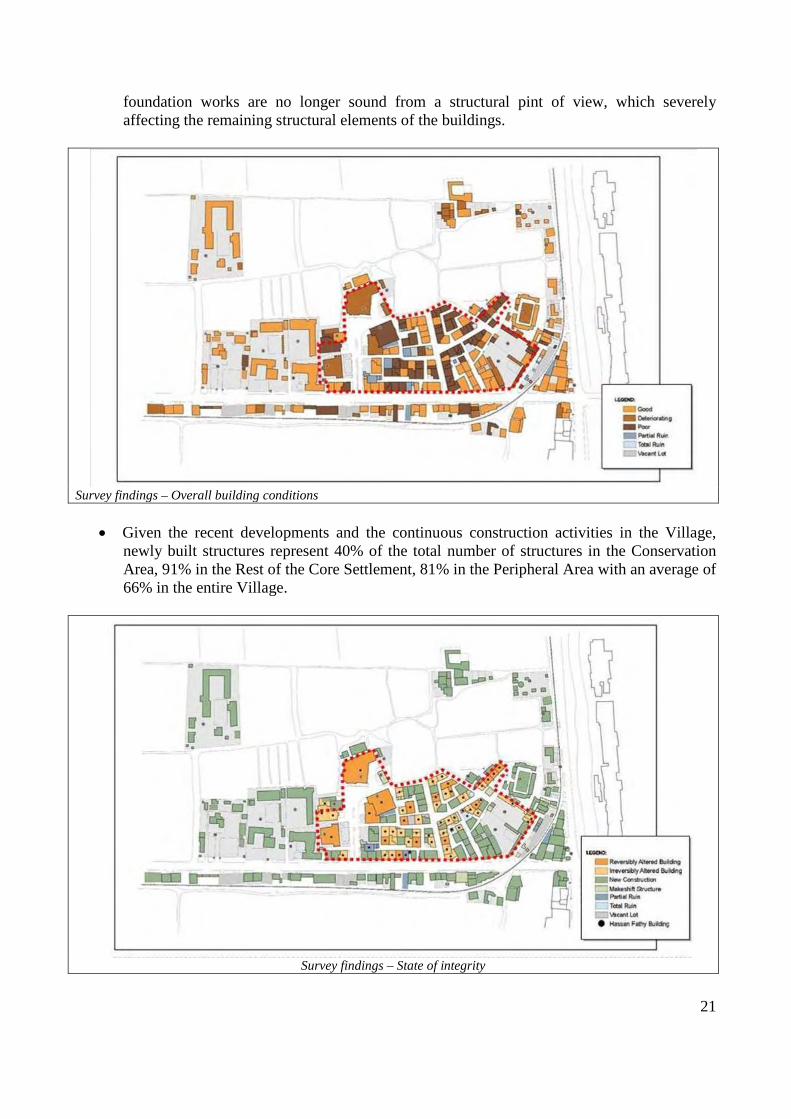
foundation works are no longer sound from a structural pint of view, which severely affecting the remaining structural elements of the buildings.
Survey findings – Overall building conditions
• Given the recent developments and the continuous construction activities in the Village, newly built structures represent 40% of the total number of structures in the Conservation Area, 91% in the Rest of the Core Settlement, 81% in the Peripheral Area with an average of 66% in the entire Village.
Survey findings – State of integrity

22
• The survey has identified 59 remaining Hassan Fathy structures (of which one structure is a partial ruin), which represent 41% of the total number of structures in the Conservation Area and 19% in the entire Village. The survey shows that 31% of the remaining Hassan Fathy structures are reversibly altered buildings, where significant traces of the original design can be traced and retrieved. On the other hand 61% of the remaining Hassan Fathy structures are irreversibly altered, since buildings have been severely modified to the extent that they cannot be retrieved to their original condition.
• In regards to architectural significance, the survey identified 9 architecturally significant buildings (15% of the total number of remaining Hassan Fathy structures), which include most of the public buildings and a few houses that still maintain their original design and features. The survey also identifies 21 buildings that have been modified but still maintain significant architectural elements (36% of the total number of remaining Hassan Fathy structures).
Survey findings – Architectural significance
• As for the land ownership and tenure, according to different interviews with the local officials, the Egyptian Government, and more specifically the Supreme Council of Antiquities (SCA) since 1945 has been, and still is the sole owner of the land. However, interviews with residents indicate that the current occupants of the houses are the owners. Yet, this is still considered as some sort of informal ownership which does not clearly define the difference between ownership of the building and ownership of the land on which it was built. Many of the residents claim that they received letters from the Government acknowledging their ownership of the buildings in return of expropriation of their original houses on the hillside. Neither the SCA, nor the local residents were able to provide the survey team with any documents supporting these arguments, except for the land expropriation decree issued by King Farouk in 1945. Additionally, it was not possible to find any recent documents related to further real estate transactions.
• In similar situations, the Egyptian law gives the occupants who occupy a property for more than a certain period of time ownership rights through the court. This is the case right now

23
where the survey shows that more than 82% of the structures are owner occupied (based on the residents’ claims). The real estate transactions take place though a court case where the buyers prove the validity of the signature of the owner/occupant of the property. This is also the case in many areas in Egypt where property registration is not really active. However, this matter needs to be further investigated not only through the ongoing socioeconomic survey, but more importantly through a legal investigation of the ownership and tenure structure in the Village. This is a highly crucial matter given any proposed upgrading plans which might involve some relocation activities or expropriation of properties.
Survey findings – Status of ownership
• At present, the number of nuclear families in New Gourna Village is 253 families, of which 49 are considered as extended families living in the same house. The total number of families can be subdivided as follows: 76 families living in Hassan Fathy structures, 111 families living in modern structures within the boundary of the Core Settlement, in addition to 66 families living in modern structures in the Peripheral Area.
• In regards to the total floor area occupied per family, the survey reveals some interesting findings that despite the fact that the original average total floor area of Hassan Fathy houses was almost 230 square meter per family, this figure has gone down to an average of 195 square meter per family (15% decrease). This figure includes the recent additions made by the residents to respond to crowding and increase in the number of families occupying the same buildings. On the other hand, there is a considerable increase of total floor area occupied by the families when comparing the modern structures in the Core Settlement with the ones in the Peripheral Area. The total floor area per family increases from 156 square meters in the Core Settlement up to 204 square meters in the Peripheral Area (31% increase).
• The average footprint area of residential buildings is 145 square meters for Hassan Fathy structures, 120 square meters for modern structures in the Core Settlement and 167 square

24
meters for modern structures in the Peripheral Area. This means that the average footprint for modern structures has also considerably increased in the later developments.
• Another important fact is the current level of occupancy in the entire Village which reaches to an average of 89% for residential units and 70% for business units. This means that any type of future intervention will have to address the need for new housing opportunities in the Village since it almost reached its maximum capacity, and cannot cope with any future housing needs if the current situation continues.
These findings, together with the residents’ preferences can give a preliminary idea about the characteristics of any proposed new housing units. It is proposed that new housing units have an average footprint of 140 square meters with the ability of vertical growth up to 2‐3 floors. Such building that can initially shelter one family can grow gradually to host 2‐3 families in the future, which is the current trend of the existing families in New Gourna. The number of the proposed housing units in the Master Plan will primarily depend on the different scenarios to address the existing families occupying the Hassan Fathy structures.
3.5. The Heritage of Hassan Fathy’s work
As previously pointed out, after the initial implementation of the Hassan Fathy’s project in 1945-47, a deep process of change has occurred that depended not only on the “internal” situation of the village (i.e. the attitude of the Gournii towards the master’s project) but also on the new context created by urbanisation process in the surrounding area. The village is no longer an isolated settlement in a rural area, but is now set at the edge of a growing urban area, close to some of the main attractions of the new tourism industry. Its development occurs without a clear and effective urban management process, promoted not only by the local inhabitants, but also by governmental agencies that have created a considerable number of public buildings and services.
25
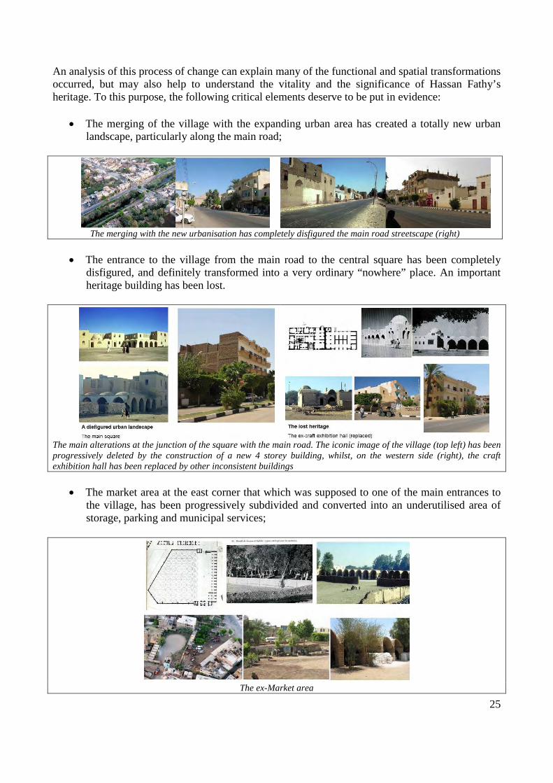
An analysis of this process of change can explain many of the functional and spatial transformations occurred, but may also help to understand the vitality and the significance of Hassan Fathy’s heritage. To this purpose, the following critical elements deserve to be put in evidence:
• The merging of the village with the expanding urban area has created a totally new urban landscape, particularly along the main road;
The merging with the new urbanisation has completely disfigured the main road streetscape (right)
• The entrance to the village from the main road to the central square has been completely disfigured, and definitely transformed into a very ordinary “nowhere” place. An important heritage building has been lost.
The main alterations at the junction of the square with the main road. The iconic image of the village (top left) has been progressively deleted by the construction of a new 4 storey building, whilst, on the western side (right), the craft exhibition hall has been replaced by other inconsistent buildings
• The market area at the east corner that which was supposed to one of the main entrances to the village, has been progressively subdivided and converted into an underutilised area of storage, parking and municipal services;
The ex-Market area

26
• The handicraft activities planned by Hassan Fathy have been abandoned. Not only the craft exhibition hall has been replaced by a residential building along the main road, but also the handicraft school near the Market area has been replaced by a structure for the cattle breeding. The development of the School of Agriculture and the building of new schools along the main road to serve the larger urban area have entailed the demolition of the Hassan Fathy’s Boy school and the Girl school.
• A considerable loss of heritage values has been entailed by the demolition and reconstruction of many courtyard houses, with concrete structures and inconsistent architectural and decorative elements. Most of all, the new constructions replicate the ordinary models of the new peripheral expansions, thus affecting the strong architectural identity of the village.

27
• The diffused interventions of reconstruction, horizontal and vertical additions, merging and subdivision of the original houses, very often out-of-scale, have completely altered the streetscape, definitely deleting in the visual distinction of some landmark buildings.
The same streetscapes in the 1980’s and today: the streets heading to the theatre (left) and to the Market (right)
On the other hand, the following aspects deserve to be valorised:
• The public buildings planned by Hassan Fathy remain as the major “focal points” of the village, even if some of them have been altered (the theatre, the khan) or even rebuilt (the community hall).
The public buildings designed by Hassan Fathy still define the square – the main of the village, in spite of some relevant alterations, made evident by the comparison with the old photos.
The fenced garden added to the theatre and the community hall that replaced the original one has sensibly modified the western side of the square (left); whilst a buildings addition and a small planted green are have considerably modified the western corner of the khan (above)
• In spite of the amputations and alterations to the housing typologies, the street layout and the residential blocks morphology have been preserved and still provide a rich articulation of

28
the public realm, thus preserving to a certain extent one of the most valuable elements of identity of the village.
The aerial views compared to the Hassan Fathy’s drawings show the persistence of the block morphology
• The few preserved public buildings and houses show the outstanding value of Hassan Fathy’s architecture, the richness and distinctiveness of the spaces created through traditional materials and simple but accurate details. Are they becoming a “niche” tourism attraction?
3.6. The socio-economic condition
A WMF team has undertaken a socio-economic survey and a “community assessment” in September 2010 that will comprise analysis of social and economic needs and conditions, factors of

29
change, use of space, and attachment to place. The methodology and the first findings were presented at the 1st Scientific Committee13, but the final report has not been finalized yet.
3.7. Critical issues
The preliminary surveys14 have put in evidence so far the following critical issues to be addressed by the Project:
Planning
Despite the fact that the western bank of Luxor might be subject to a master planning process, it was evident through the physical survey and interviews with the local officials that no planning related documents regarding New Gourna Village currently exist. The Village lacks Master and Detailed Plans that set the framework for the recent developments and construction activities. What currently exist are minimal regulations that mainly focus on building heights which are barely implemented, and often violated by the residents.
Therefore, and given the lack of any planning framework or efficient urban management mechanisms, the Village has been suffering from vertical growth ‐ mostly in the Core settlement, and horizontal unplanned growth through informal building activities along the main roads. In addition, lack of clear building regulations and guidelines resulted into the emergence of new building typologies and architectural features that are in complete contradiction with the original context of the Village.
Public Buildings
Hassan Fathy’s Public buildings not only enrich the architectural identity of the Village but also may represent an important functional asset. On the other hand, the several recent administrative buildings, facilities and services in the rest of the Core Settlement have made the Village the central area in the larger urban context, but have definitely spoiled its peculiar image. An overall improvement is needed, together with urgent interventions to prevent further losses:
• The Khan, recently affected by further serious structural collapses, and the remaining market vaults need for immediate structural consolidation and require interventions of adaptive reuse;
• The Mosque still remain the focal point of the village but requires to be valorized through appropriate landscaping of the surroundings;
• The Theater needs maintenance and plans for a continuous use; • The very poor environment created by recent buildings need to be improved through
appropriate landscape interventions to ensure a closer relationship with the public open spaces, including the remodeling of the volumes and the facades;
13 See the meeting report cited
14 The socio-economic survey and the community assessment have not been finalized. Their findings and proposals will be taken in consideration by the Project in the following stages.
30
• The diffused lack of maintenance needs to be addressed through efficient management;
Housing
Residents of the Village currently suffer from serious housing related problems, especially those who occupy houses that were originally designed and built by Hassan Fathy. Some of these problems are:
• The increasing housing demand in the Village and lack of horizontal growth options with the consequent densification of the original residential blocks (the original Hassan Fathy’s 70 residential plots in the “conservation area” are now occupied by 174 households);
• Lack of potential for development or growth in the Hassan Fathy’s buildings that can accommodate the increasing spatial needs of the inhabitants;
• Inability of these buildings to adapt with the current residents’ lifestyle requirements such as the need for air‐conditioning or satellite dishes, etc.;
• Heavy and diffused structural damage and deterioration of the living conditions.
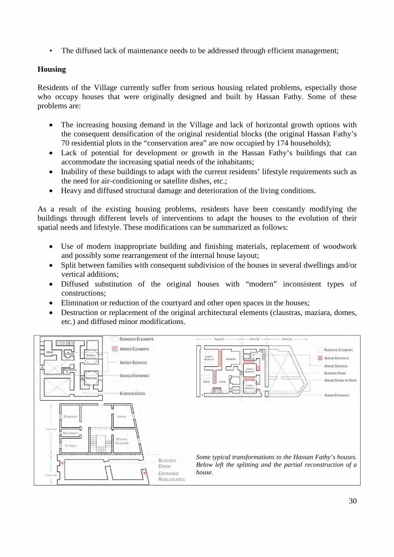
As a result of the existing housing problems, residents have been constantly modifying the buildings through different levels of interventions to adapt the houses to the evolution of their spatial needs and lifestyle. These modifications can be summarized as follows:
• Use of modern inappropriate building and finishing materials, replacement of woodwork and possibly some rearrangement of the internal house layout;
• Split between families with consequent subdivision of the houses in several dwellings and/or vertical additions;
• Diffused substitution of the original houses with “modern” inconsistent types of constructions;
• Elimination or reduction of the courtyard and other open spaces in the houses; • Destruction or replacement of the original architectural elements (claustras, maziara, domes,
etc.) and diffused minor modifications.
Some typical transformations to the Hassan Fathy’s houses. Below left the splitting and the partial reconstruction of a house.

31
Public Spaces & Infrastructure
The street morphology and public open spaces in New Gourna still maintain most of their original structure. However, the overall image of the Village has been severely compromised due to the recent developments and the on‐going construction activities. This situation has aggravated to the extent that, even for a part of the Village’s main square, it is difficult to identify the original character of the Village.
These developments together with the deteriorated infrastructure have left a negative impact on the integrity of the public open space treatments that used to characterize New Gourna. The following major problems need to be address as a priority:
• The sewage system currently relying on septic tanks is completely inadequate. As a result, high water table and rising dampness have severely affected the buildings and the streets surface, which mostly consist of compacted soil. However, any attempt to replace this system with a new sewage network should consider the structural implications of the new system on the Village buildings;
• The Village suffers from increased visual clutter due to the use of inappropriate streetscape elements. This is attributed to the fact that the Village lacks any sort of guidelines controlling the public open space treatments;
• The visual image of the Village is almost lost either on the level of streets, vistas or small public open spaces. This is due to the continuous building violations and the use of inappropriate finishes and facade treatments, either in Hassan Fathy buildings or in the new developments;
• The Village lacks a sustainable approach towards vegetation and landscape which is very much needed given the difficult environmental conditions of the site. New Gourna used to have a considerable number of trees, either in the public open space or in public services such as the Market Place. Currently this green cover has completely gone and needs to be reintroduced on sustainable terms.

32
4. THE MASTER PLAN PROPOSALS
4.1. The objectives
The Master Plan covers the whole area of the original plan of Hassan Fathy along the road connecting the Luxor ferry to the King’s Valley. Following the recommendations and suggestions of several missions and petitions, the outcomes of the workshop held in April 2010 and the International Experts meeting in October 2010, as well as the concerns of the local authorities, the Master Plan considers that:
• The preservation and valorisation of Hassan Fathy’s heritage, concerns not only the outstanding architecture of the public buildings and houses which remain intact, but also the village concept, the urban layout and the spatial texture of the residential blocks, which are still preserved to some extent. Most of all it implies the reviving and the strengthening of New Gourna as an integrated settlement, the place of a vital and developing community;
• The creation of the International Centre for Sustainable Architecture (ICSA) is a fundamental option, derived from Hassan Fathy’s vision. The Centre will provide training and research opportunities for Egyptian and international students so that the same humanistic principles and ideas of Hassan Fathy would be continued and projected into the future. This will make the ICSA an essential driver for the rehabilitation and valorisation of the Hassan Fathy’s heritage, and the village the “brand location” for the new institution;
One these bases, the master Plan develops an approach to the safeguarding of New Gourna that would include the following interrelated actions and concepts:
• The rehabilitation of the residential blocks and the improvement of the housing conditions. These are heavily affected by the densification of the original fabric caused by the subdivision of plots, the vertical and horizontal additions, the diffused alterations to the structures and the domestic spaces, and finally, particularly in recent years, the reconstruction of several houses with out-of-scale concrete buildings;
• The revitalisation of the village, with the strengthening of the community core and the upgrading of the public spaces and facilities. This includes the restoration and the adaptive reuse of the Hassan Fathy’s buildings (particularly the Khan, the theatre and some houses) and the upgrading of the market area with the restoration and valorisation of the remaining original structures and spaces;
• The physical and socio-economic development of the village. On the one hand, a relevant extension of the existing residential pattern is required to resettle about half of the resident families, which would be concerned by the different types of intervention for housing rehabilitation. On the other hand, the location of the village and its urban context suggest, beyond the creation of the ICSA, the reorganisation and reinforcement of the existing agricultural and administrative facilities, the creation of new handicraft activities, and the possible creation of accommodation facilities closely linked to the presence of the ICSA (such a small hotel and guest houses) and to the possible development of ecological tourism (to be very carefully evaluated).

33
4.2. The proposed planning strategy
The Master Plan intends to outline the spatial framework for the coordinated implementation of these different actions, which should be carried out through specific and detailed conservation and development projects, under the supervision and the technical coordination of the ICSA.
The proposed land use and conservation measures are based on some preliminary considerations concerning the urban context, particularly:
• The privileged location on the main road connecting the ferry to Luxor to the East (1,7 km.) and the main attraction of the Kings valley to the West
• The merging with the undergoing urban sprawl, which developed along the road and the canal running N-S.
These two aspects explain the strong pressure toward transformation and the risk of a definitive loss of the recognised heritage values. To this purpose, the following objectives are set:
• To enhance the identity of the village giving emphasis to the HF architectural heritage, enhancing the urban landscape and open spaces (particularly the entrances to the village), re-establishing the original skyline and the visual relationship with the mountains;
• To eliminate (when possible) and mitigate the impact of the recent development along the main road through interventions of “remodelling”, “harmonisation” and demolition;
• Benefiting from the available opportunities such as the new development plans taking place in Luxor Governorate, the increased interest of local and international institutions in safeguarding Hassan Fathy heritage, and the anticipated increase of the level of visitors’ activities;
• Ensuring the sustainability of the safeguarding approach through the development of a comprehensive institutional and planning framework.
The implementation of these strategies will require the consolidation of the existing Village, harnessing uncontrolled development in the Peripheral Area, and the introduction of controlled growth and development opportunities through the continuation of the Village layout to meet the increasing housing demand and provide land for new facilities and services such as the ICSA.
To this effect, the proposed Master Plan aims at providing the framework to develop the detailed action plans and intervention projects that are required to ensure the effective implementation of the safeguarding and regeneration strategy.
It is important to stress that the Master Plan intends to reflect the peculiar “multipurpose” character of the Project. If the Hassan Fathy’s heritage should obviously become the “anchor” for the rehabilitation, revitalisation and development of the Village, the safeguarding should be implemented through a series of combined actions that would include:
• The conservation and adaptive reuse of the Hassan Fathy’s buildings (the theatre, the khan, the “HF houses” with higher degree of authenticity);
• The rehabilitation of the major public spaces designed by Hassan Fathy at the entrance of the village, i.e. the market area and the main square, as well as the urban front along the main road;

34
• The preservation and continuation of the Village layout adopting the planning and urban design criteria of the original Hassan Fathy’s project not yet implemented, to meet the housing demand and ensure the new development opportunities;
• The provision of land for the proposed ICSA and other future activities (different options, see also the HF projects of the ‘70s) within the same framework outlined above.
The safeguarding strategy should be developed through the following steps and actions described in the following sections:
• The application of Protection measures based on the existing legislation, particularly the Law n.119-2008;
• The definition of Conservation and Land Use measures with related regulations and guidelines;
• The identification of urgent and long term interventions.
4.3. Protection measures
Protection measures should be urgently established and enforced based on law 119-2008. According to the suggestions of the 1st Scientific Committee, these would consist in the following:
a) The definition of an “Area of peculiar value” (art.33), corresponding to the “core settlement” as defined above. This would include:
• The “conservation area”, i.e. the part of the settlement reflecting the Hassan Fathy’s plan and comprising the buildings he designed and built, set as “area of maximum protection”;
• The “rest of the settlement core”, i.e. the area covered by the original plan of Hassan Fathy, but partially developed in the following years with inconsistent and scattered interventions mainly for public purposes;
b) The definition of a “Buffer Zone”:
• This would consist in the “peripheral area”, as defined above
c) The “registration” of the Hassan Fathy’s building, being identified by the Physical Survey, to be submitted to different degrees of protection according to their degree of integrity. This would include:
• The public buildings • The houses with higher degree of integrity • The houses showing some original element
The definition and the approval of these measures should be considered as a priority to be undertaken immediately.
4.4. Conservation and Land Use measures
A Conservation and Land Use zoning is proposed for the “core area” corresponding to the whole area covered by the original project of Hassan Fathy, with related planning and building regulations

35
and guidelines, which identifies the areas and the buildings where the following interrelated actions will be implemented:
• The preservation and rehabilitation of the “conservation area”, corresponding to the part of the settlement that was implemented according to the Hassan Fathy’s plan, where his buildings are concentrated;
• The regeneration and development of the “Rest of the core area”, with the reorganisation of the existing public facilities and agricultural activities, the creation of the ICSA, housing development to meet the resident’s needs, and a possible eco-tourism settlements.
General Conservation and Land Use Zoning Proposals
In particular, in the Conservation Area, the proposed measures and interventions are aimed to the following objectives:
• The preservation and recovery of the original Hassan Fathy’s village layout; • The restoration and adaptive reuse of Hassan Fathy’s public buildings and houses • The overall housing rehabilitation • Overall improvement of urban infrastructure and public spaces
In the Rest of the Core Area, the proposed measures and interventions are aimed to the following objectives:
• The maintenance and improvement of the existing public services and facilities, administrative activities and technical plants;
• The reorganisation of the agricultural facilities and activities; • The creation of ICSA;

36
• New housing development to meet the village resident’s needs; • The possible development of eco-tourism activities;
To these purposes, different types of interventions are proposed for each building, based on the physical survey:
a) Actions to preserve:
• Preventive maintenance and repair of elements (i.e. the recent public buildings along the main road: schools, town hall, etc.)
• Restoration (the mosque, the khan, the theatre, the few houses with higher degree of authenticity)
• Adaptive reuse (some of the restored public buildings can be reused based on the Master Plan’s proposed functions);
• Rehabilitation (all houses with some degree of authenticity) • Reconstruction based on the reinterpretation of the original Hassan Fathy’s project
b) Actions to transform:
• Remodelling (all rebuilt houses up to the second floor) • Partial demolition (the vertical additions above the second floor, the horizontal additions) • Total demolition • New development (the ICSA and the new housing developments).
Preliminary definition of the Types of interventions on existing buildings

37
4.5. The Conservation Area
In the Conservation Area, the maximum level of protection should be ensured, as an “area of peculiar value” to be established according to law n. 119-2008 (see section 4.3). This is meant to preserve, recover and valorise all of the conceptual and physical elements that constitute the living heritage of the Hassan Fathy in New Gourna, i.e. the planning concepts, including the sense of community that shaped the urban layout, the architectural work, the public spaces and their relationship with the domestic space.
Detailed prescriptions for the Conservation Area
The proposed measures and interventions manly concern the following aspects:
Preservation and rehabilitation of the original village fabric and layout
An overall rehabilitation of the village urban is proposed that aims at eliminating or reducing the impact of the main alterations in the spatial layout and visual relationships. This implies:
• The demolition of all the buildings and horizontal additions that seriously affect the shape and spatial significance of the street layout and the main public spaces. The proposed interventions aim at recovering the original street alignments;
• The reduction of the building height of the recent buildings exceeding the building height of the Hassan Fathy’s buildings. Interventions of partial demolition or total demolition and reconstruction are required to bring back the height of the building front’s height to the

38
original one. Moreover intervention of remodelling of the facades are required in order to eliminate balconies and other protruding or cantilevered elements;
• The rehabilitation of the main square, to be implemented not only with the restoration and adaptive reuse of the existing public buildings (see below), but also with the demolition of the recent buildings surrounding the mosque, and the reshaping of the central space. All of the added fencing walls and traffic islands should be eliminated in order to recover as much as possible the integrity of the square in its extent. Appropriate landscaping and paving has to be provided in order to accommodate both pedestrian and vehicular mobility and parking, ensuring the spatial continuity of the square;
• The rehabilitation and regeneration of the market area, to recreate a pedestrian entrance to the village from its south-eastern edge. The area should be remodelled and landscaped to recover its original extent as a public space, partially planted with trees and partially paved as a square, to accommodate different uses – a public garden, a temporary market place, a space for special events, festivals and similar uses.
Restoration and adaptive reuse of Hassan Fathy’s public buildings and houses.
The restoration is proposed of the public buildings and houses designed and built by Hassan Fathy and preserved at a high degree of integrity. The interventions are to be carried out according to the established international standards, based on the original drawings and project specifications, and should be aimed at preserving the existing uses, when compatible, and to adaptive reuse in the case of dismissed or unused buildings.
In particular, it is proposed to reuse for new functions the following buildings, to valorise or reinstate the original functions that were intended to make the village an integrated “community”:
• The Khan; to possibly recover the functions of the handicraft exhibition hall demolished in the 80’s;
• The Market vaults, to be kept as public covered open space for different uses; • The house of Hassan Fathy, to exhibit documents and materials concerning the projects of
the Master for New Gourna
Housing rehabilitation
The rehabilitation and upgrading of the existing building stock in the Conservation area, to be implemented through different types of intervention, ranging from restoration to demolition, in order to reduce the housing density and recover as much as possible the original texture. This requires:
• Emergency interventions on seriously deteriorated and abandoned buildings; • Widespread rehabilitation interventions; • Interventions of demolition and reconstruction or remodelling on out-of-scale and offensive
buildings;
These interventions would be possibly implemented though integrated and localised projects combining rehabilitation, reuse and infill on vacant plots.

39
4.6. The “rest of the Core Area”
The “rest of the Core Area”, is to be established as an “area of peculiar value” according to the law 119 - 2008 (see section 4.4) to be protected from uncontrolled development, in order to implement actions related to rehabilitation and revitalisation of the Conservation Area, continuing and eventually completing the Village with new structures and functions, reviving the spirit of Hassan Fathy planning concept. In this framework the following measures and interventions are proposed:
Spatial layout
All of the interventions proposed for the “rest of the Core Area” are set in a planning framework that aims at continuing the spatial layout of the “conservation area”, respecting the original project planning and urban design principles. The intention is not to replicate the Hassan Fathy’s plan – this would be impossible without too expensive end useless demolitions – but to explore its high potential for creating an integrated community.
To this effect the Master Plan has outlined a grid of blocks and street, which is reminiscent of the original one, but incorporates the existing settlements and is intended to integrate different non residential functions and housing development, focussing on the main square and other “focal points” to be created.
Reorganisation and rehabilitation of the existing services and public facilities
The existing functions have to be maintained and reinforced in order to keep the role of New Gourna as a service provider for a larger urban area. To this effect, the following measures and intervention are proposed in the rest of the Core Area:
• To complete the main square surrounding the mosque, with a series of public buildings that would reinforce its function of “central place” for the whole village. This would namely include, on the north-western side, the reconstruction of the “community hall” reinterpreting the planning concept of the demolished building of Hassan Fathy, and the construction of a new built front to accommodate the most “public” functions (lecture hall, exhibition rooms, etc.) of the future ICSA (see below);
• To maintain the existing public services, administrative buildings and technical plants, along the main road and on the eastern side, providing in some case the possibility of an expansion on an adjacent area. These structures require overall interventions of harmonisation to the urban context, which may consist in the façade remodelling, the appropriate landscaping of the surroundings;
• The relocation of the cattle breeding station, and other administrative offices and scattered buildings belonging to the department of Agriculture next to the existing School of Agriculture on the north-western edge of the area, in close relationship with the rural land. This would create the opportunity to continue the fabric of the “Conservation Area” according to the planning concepts of the original Hassan Fathy’s project;
• The construction of a new handicraft training centre (or a similar function) at the south-eastern edge of the Core Area, in the same location of the demolished school, at the entrance of the Village;

40
The creation of the ICSA
The construction of the future premises of the ICSA is proposed in the framework of the system of blocks and streets of the future development. The Centre would be strongly integrated in the fabric of the village, set in a central position to complete the square next to the mosque, and would extend to the west next to existing schools and administrative buildings.
It would occupy different blocks reflecting the articulation of the different activities proposed by the preliminary documents (see Annex 3) – training and dissemination, research and laboratories, accommodation for national and international staff and trainees. A detailed feasibility study is needed to develop a consistent planning concept. Guest houses (linked to ICSA),
New Housing development
The possibility of a new housing development is provided to meet the resident’s needs of new houses that may result from the rehabilitation of the “conservation area”. This would cover the northern and eastern parts of the village, extending the existing pattern and respecting wherever is possible the Hassan Fathy’s original layout, particularly the entrances to the site and the street pattern, the “focal” role of the mosque and the community centre, the morphology of the housing blocks)
If a definite estimate of the housing needs is not possible at the moment due to the lack of comprehensive information, t is considered that the proposed interventions of demolition, partial reconstruction and rehabilitation combined to the reduction of the present housing densities, would require in the long term the resettlement of about 120 households.
New housing development should be consistent with the Conservation Area planning principles, and would consist of two storeys houses, grouped in “open” blocks with semi-public courtyards and lanes, with plots of an average size of about 100 meters and dwellings of 150 square meters with an inner courtyard. The morphology of the blocks and the building typologies should be defined by specific development plans and action projects, to be carried out on the bases of a comprehensive Housing Study (see chapter 5).
Eco - Tourism development
According to the conclusions of the 1st Scientific Committee meeting, tourism would not be the main focus of the Safeguarding Project. It is considered that the possible development of tourist activities should achieve the following:
• Maximizing the community benefit of the expected visitors’ activities and mitigating their negative impact such as uncontrolled gentrification;
• Emphasizing the ‘Value’ of Hassan Fathy heritage as well as sustainable planning and architecture in general;
• Improving the sites’ overall physical conditions and accessibility to cope with the expected level of tourism visitors’ activities;

41
• Improving existing services and introducing new facilities to provide an acceptable level of service in order to accommodate the visitors’ needs (local coffee shops, public toilets, setting areas, etc.);
• Making information on the site, its values and its historic development available for the visitors through training of guides, production brochures and instruction of onsite interpretative signage.
In this framework, the Master Plan identifies the land for a possible eco-tourism development on the western edge, Similar to Hassan Fathy’s Gourna Touristic Project of 1970, but in a different location, the settlement should be next to the residential area, but not interfere too heavily with the village life and its community spaces. In this regard, the proximity to rural areas and agricultural activities could be considered as an asset to valorise.

42
5. THE IMPLEMENTATION OF THE MASTER PLAN
The Master Plan identifies the actions to be undertaken in the framework of the Safeguarding Project, i.e.:
• The emergency and priority actions that are necessary to stop the physical decay of the village, prevent any further loss of the Hassan Fathy’s heritage and start the rehabilitation of the village;
• The long term conservation actions to ensure a sustainable Safeguarding process combining housing rehabilitation, heritage valorisation and socio-economic development.
The implementation of the Master Plan is to be considered as a fundamental condition for the development of the Safeguarding Project. To this purpose, the following planning and management activities are required to set a consistent legal and institutional framework for the different interventions. These activities include:
1. The approval of the Master Plan including the Protection Measures, the Conservation and Land Use zoning and the related planning, urban design and building regulations and guidelines;
2. Putting in place institutional instruments and efficient urban management mechanisms to ensure the sustainability of the proposed emergency, priority and long-term actions;
3. Capacity building of local municipal administration on the management and implementation of the Master Plan and its related interventions
5.1. Emergency and priority actions
Emergency actions
The following emergency and priority actions are propose to stop the ongoing process of decay and prevent further losses of Hassan Fathy’s heritage: undertake the process of rehabilitation and valorisation of Hassan Fathy’s New Gourna:
1. Taking the legal measures to declare New Gourna as a conservation area with special architectural character (the Core Settlement); with the definition of the boundaries of the Conservation Area, the Core Settlement and its immediate buffer zone (the Peripheral Area);
2. Taking the legal measures to issue an immediate building moratorium to stop the ongoing construction, additions and building modification activities;
3. Undertaking urgent interventions for emergency shoring to structurally consolidate major buildings of the Village (the Khan, the Theatre, Hassan Fathy’s houses, the Suq and others); these are indicated in the map
Priority actions
In parallel with the emergency actions the following priority studies and interventions have to be undertaken in order to start a process of rehabilitation and valorisation and create the conditions for long term conservation activities:

43
1. Carrying out an official survey to identify the existing occupants and conduct in‐depth investigation of housing tenure and land/buildings ownership status;
2. Establishing an appropriate legal framework (including land and building tenure) for housing rehabilitation and development interventions.
3. Undertaking the rehabilitation of unoccupied HF buildings to be used for temporary resettlement of households interested by rehabilitation/remodelling or reconstruction interventions.
4. Undertaking the partial demolition and remodelling of the most offensive and intrusive buildings (4 storeys, 3-4 storeys buildings on the main square and along the main streets).
5.2. Long term conservation activities
Surveys and documentation
Completion of Surveys and Documentation research:
• Socio-economic survey • Documents on HF activity and the story of New Gourna Village
Development planning and action projects
Development of different intervention plans, programs and activities which will cover the following aspects:
• The completion of the Master Plan, its related technical documents and proposing effective urban management mechanisms;
• The overall housing rehabilitation of the Village, remodelling of modern structures and the introduction of new housing development either through ‘infill’ or the development of the new Village residential extensions;
• The restoration and adaptive reuse of remaining Hassan Fathy public buildings; remodelling of newly developed public buildings and introduction of new services and facilities required by different stakeholders such as the ICSA;
• The overall upgrading of public open space and infrastructure networks and proposal of streetscape, landscape and urban design guidelines;
• The development of socioeconomic initiatives and responsible tourism concepts to support local development and create new jobs in the fields of conservation and tourism services;
• Implementation of pilot projects focusing on the integration of housing, public buildings, open space, infrastructure, socioeconomic and responsible tourism interventions;
• Putting in place, based on the outcomes of the different interventions, efficient institutional instruments and management mechanisms to ensure the sustainability of these interventions.
Housing policy development
Housing interventions require the development of a comprehensive process rather than short‐term projects. The following is a summary of the main elements of this process and its required actions:
1) Development of new housing models to better understand:
• The preferences and spatial needs of the inhabitants;
44
• The existing structural problems, techniques of rehabilitation and new construction options.
The housing study will entail the following actions:
• Document some of the remaining Hassan Fathy's and newly transformed or reconstructed houses, based on a selection criteria;
• Trace residents’ modifications and spatial preferences in Hassan Fathy’s buildings and the newly reconstructed houses;
• Analyze and categorize existing housing prototypes and typologies; • Identify existing structural problems, building materials and construction methods, • Carry out needs assessment and participatory design sessions with the residents for
rehabilitation of existing houses and development of new housing models; • Propose rehabilitation techniques for existing houses and develop sustainable building
technologies for construction of new housing.
The outcome of this housing study will be two manuals (addressing rehabilitation of existing housing and the construction of new housing models) focusing on: i) housing design criteria, and ii) rehabilitation and new sustainable building materials and techniques.
2) Based on the inhabitants’ preferences and the proposed Master Plan, the study should also develop scenarios to address tenure related issues in the existing Hassan Fathy housing units which might include one or a combination of the following options:
• Housing rehabilitation and maintaining of the existing inhabitants; • Evacuation, rehabilitation and adaptive reuse of the existing housing units;
3) Evaluation of the housing needs resulting from the rehabilitation and upgrading actions (i.e. the elimination of the plots subdivisions, the partial demolitions and remodelling, etc.) which will involve:
• Identification of emergency and priority interventions and possible rehabilitation/reuse/infill pilot projects;
• Identification of localized infill and reuse projects; • Preparation of detailed plans for new housing developments, continuing the original Hassan
Fathy layout).
4) Implementation of different housing interventions in participation with the local inhabitants, which will involve the following activities:
• Setup institutional mechanisms for housing finance and resolving housing tenure and ownership pending issues;
• Development of affordable rehabilitation techniques and sustainable building technologies for housing models and introduction of energy saving measure;
• Rehabilitation and upgrading of the existing building stock (different types of interventions); • Construction of new housing models in the proposed extensions of the Village.

45
Overall improvement of urban infrastructure and public spaces
The upgrading of the public open space and infrastructure will involve the following activities:
• Assessment of the existing infrastructure conditions; • Participatory appraisal of the residents’ needs in terms of required public open space
improvements; • Production of a design and construction manual focusing on the proposed streetscape feature
and elements as well as sustainable vegetation and landscape elements; • Production of a detailed study on the proposed infrastructure interventions and their
implications on the existing buildings; • Implementation of infrastructure improvements and public open space upgrading pilot
projects, with a special focus on the Village main square and the Market area.

46
ANNEXES
1. List of participants to the 1st Scientific Committee Meeting, Luxor 2-3 October 2010
2. Project Road Map proposed by the 1st Scientific Committee Meeting, Luxor 2-3 October 2010
3. The Hassan Fathy International Centre for Sustainable Architecture. UNESCO preliminary ideas

47
1. List of participants to the 1st Scientific Committee Meeting, Luxor 2-3 October 2010
Egyptian Institutions Mr. Samir Farag Governor of Luxor Mr. Abbas el-Zafarany Ministry of Culture Ms. Sohair Zaki Ministry of Culture List of Members of Scientific Committee Mr. Benno Albrecht Venice University’s Institute of Architecture Mr. Gamal Amer Ministry of Culture – Egypt Ms. Erica Avrami World Monuments Fund Mr. Baba Alpha Ismail Cissé Bureau d’Etudes d’Architecture et d’Urbanisme Ms. Leila el-Wakil University of Geneva Mr. Hubert Guillaud CRAterre-ENSAG Mr. Ahmad Hamid Ahmad Hamid ARCHITECTS Mr. John Hurd ICOMOS Mr. Joseph King ICCROM Ms. Adelina Picone Federico II University of Naples Ms. Jana Revedin Jana Revedin Architects Mr. James Steele University of Southern California Ms Ana Tostões DOCOMOMO Ms. Gihane Zaki Ministry of Culture – Egypt Experts Ms. Nevine George Hanna Akl Consultant, Survey Team Ms. Gina Haney Consultant, Survey Team Mr. Mahmoud Ahmed Qutb Consultant, Survey Team Ms. Dalia Nabil Consultant, Documentation Research Mr. Daniele Pini Consultant, Scientific Supervisor Mr. Francesco Siravo Aga Khan Trust for Culture UNESCO Staff Mr. Francesco Bandarin Assistant Director-General, Culture Sector Mr. Lazare Eloundou-Assomo World Heritage Center, Chief Africa Unit Ms. Franca Miglioli World Heritage Center, Program Specialist

48
2. Project Road Map proposed by the 1st Scientific Committee Meeting, Luxor 2-3 October 2010
PHILOSOPHY
A. The preservation and valorisation of Hassan Fathy’s Heritage, consisting of: - design process, - outstanding architecture of the few public buildings and houses which remain intact, - village concept, - urban layout and the spatial texture of the residential blocks, - technology, - material - community
ROAD MAP Short term actions (first year):
A. Knowledge of the current situation: - Completion and extension of the surveys - Hydro-geological assessment - Legal aspects (institutional level, tenure issue, legal system for effective planning measures) - Infrastructural assessment – sewage, roads, networks - Documentation of history of the village (on-going) – including chronology of deterioration
B. Finalization of the Master Plan
1) Submission to the Organization of Urban Harmony and the Supreme Council of Urban Planning (June 2011?)
2) Start-up of the management plan 3) Creation of local Task Force
C. Emergency stabilization
1) Empty houses 2) Khan 3) Hassan Fathy’s house 4) Market
D. Listing of the buildings of Hassan Fathy
E. ICSA
1) Feasibility study to define scope and purpose 2) Legal study and establishment 3) Initial staff and structure (monitoring team) 4) Temporary offices 5) Terms of reference for the invited competition for the ICSA design 6) Studying climate engineering and local resources
F. Participation and Communication Strategy
1) Identification of community focal points 2) Identification of stake-holders 3) Continual dissemination of information and consultation with the community
Mid-term (1-3 years):

49
A. Architectural Design of ICSA (through invited competition) B. The rehabilitation of the residential blocks designed by Hassan Fathy through different types of
intervention, ranging from restoration to the demolition, to reduce the housing density and recover the original texture;
C. The construction of ICSA. This would include guest houses for teachers, scholars and students;
D. Design of other elements
E. Implementation of environmental remedial action
F. Sewage and other network and infrastructural systems

50
3. The Hassan Fathy International Centre for Sustainable Architecture. UNESCO preliminary ideas
The idea of sustainability in architecture finds its concretization in the work of Hassan Fathy, and certainly through numerous building projects not only in Egypt but also in European countries as well as in United States. His architectural work addressed many aspects of the concept of sustainable architecture.
The conception and realization of New Gourna village for Egyptian peasants using available resources, employing self-help methods, applying vernacular construction techniques, while recognising social and cultural aspects of architecture, can be considered as the most inspiring manifestation of his vision that every advance in technology has always been directed toward man's mastery of his environment.
Safeguarding this important architectural oeuvre will therefore mean to perpetuate and promote the ideas of Hassan Fathy’s, who is considered as the “Middle East father of sustainable architecture”.
It is in this context that UNESCO considers that the major outcome of this initiative for the safeguarding of New Gourna should be the establishment of an International Centre for the Sustainable Architecture.
The Centre is viewed as a multidisciplinary research and education Institute that would be a place where training, research and se will be organized on the subject of sustainable architecture and culture.
In order to define the core activities of the Centre, strategic orientations will have to be defined by the Scientific Committee in order to ensure that activities organized are not only for pedagogic and technical purpose but also for promotional of the sustainable architecture message within the context of built environment.
It is expected that the International Centre will at least propose the following activities:
1) Training
The Centre will make available spaces for training courses to be organized on various topics of sustainable architecture for technicians and practitioners. Groups of students from different universities and Schools of Architecture from the world will have the opportunity to stay in the Centre and conduct practical training and experiments.
2) Research and documentation
Various laboratories and a library will be made available for invited researchers, students, and university lecturers to conduct studies and research on the work of Hassan Fathy and related

51
subjects on sustainable architecture. It is expected to have the library made of documents donated by various institutions such as the American University of Cairo, the Aga Khan, IUA, etc…
3) Seminars and experiments
Meeting rooms will be made available for the organization of seminars and international conferences on various issues of sustainable architecture. Meetings will accommodate 50 to 100 persons
4) Residence for researchers and students
Facilities such as bedrooms, and restaurants should be made available for a maximum of 50 persons.