sam houston parkway/tollway, beltway 8 · sam houston parkway/tollway, beltway 8 even before the...
TRANSCRIPT
Sam Houston Parkway/Tollway, Beltway 8Even before the alignment of Loop 610 had been finalized, the city of Houston was
formulating plans for a second loop. It was a remarkable act of vision and foresight to rec-ognize the future importance of loop highways in today’s predominant suburb-to-suburb transportation patterns. However, the first wave of freeway construction in Houston from the 1950s to the 1970s came and went with very little progress on the Beltway.
The age of the Houston Beltway arrived with the second wave of Houston freeway con-struction, which started in the 1980s. By 1996 the entire loop had been constructed in some form—freeway, tollway, or frontage road. Completion of the South Belt main lanes in 1997 left only one segment without main lanes. The phenomenal success of the Sam Houston Tollway, the toll main lanes of Beltway 8, even brought traffic congestion to the western and northern sections of the tollway.
Although the main lanes of Beltway 8 are, for the most part, not very interesting, the Beltway has one of the nation’s most impressive collections of modern four- and five-level freeway-to-freeway stack interchanges. The Beltway is also unusual in that its tollway sec-tions have continuous toll-free frontage roads.
OriginsBeltway 8 had its origins in a 1952 report by the City
of Houston Planning Department, Proposed Location for An Outer Belt Drive for Metropolitan Houston. The report was prepared as a basis for fixing a location for a mini-mum 120-foot-wide (37 m) thoroughfare located four to five miles (6 to 8 km) beyond the city limits, which were generally located near Loop 610 at the time. The 1952 an-nual report of the City of Houston Planning Commission went on to explain, “This report was prepared in view of the imminent development of much of the area through which the thoroughfare would need to pass and because there will be a great need for such a thoroughfare in the future as the population of the urban area spreads.” At the time the report did not envision the Outer Belt as a freeway. Ralph Ellifrit, city of Houston planning director, was the individual most responsible for the birth of the Outer Belt.
In September 1954, based on the recommendation of Ellifrit, the corridor width was increased to 150 feet (46 m) to accommodate a larger arterial highway. Also in 1954, the City of Houston Planning Department performed de-tailed studies to fix the location of the Outer Belt. Nearly all of the alignment defined in that period would become the ultimate route of today’s Beltway 8.29
In 1960 Harris County stepped forward and took the leading role in the development of the Outer Belt. Harris County Judge Roy Hofheinz appeared before the Houston Planning Commission in March to discuss the merits of changing the Outer Belt to a full freeway on a minimum 300-foot-wide (91 m) right-of-way. On July 11, 1960,
Harris County Commissioner’s Court voted to increase the corridor right-of-way width to 300 feet and grant it full freeway status. Harris County would now be in charge of building the 87-mile (139 km) freeway loop. Getting into the freeway-building business was a big undertaking for Harris County and would ultimately be more than it could manage on its own. As of April 1960, a 300-foot-wide right-of-way corridor had been obtained for only 8 miles (13 km). Seven miles (11 km) had 150–250 feet (46–76 m) set aside, and 15 miles (24 km) had 120 feet (36 m) or less set aside. For the remaining 57 miles (91 km), no right-of-way had been acquired. However, only 1 mile (1.6 km) was listed as passing through a built-up area with “damage to buildings.” The projected cost of the Beltway was $150 million, still a relatively low cost after adjusting to 750 million in 2003 dollars.30
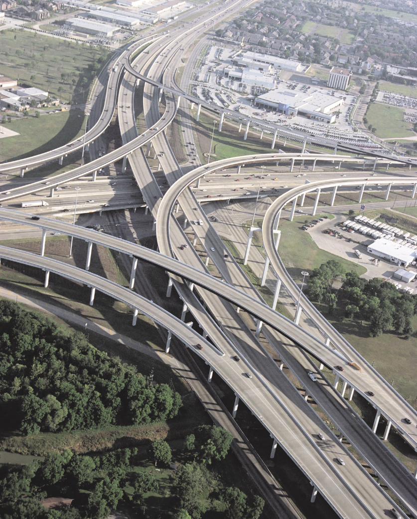
(Opposite page) The Southwest Freeway interchange: Beltway 8 gently curves through the interchange, completed in 1997. The Beltway 8/Sam Houston Tollway has an impressive collection of modern, multilevel stack interchanges. (Photo: May 2003)
Beltway 8 (Sam Houston Parkway/Tollway)Designated as freeway 1960First freeway section open 1970 (overpasses only)
1982 (toll bridge)Freeway/tollway complete Scheduled 2007Reconstruction Intermittent pavement
repair onlyMax traffic volume, 2001 233,000 vehicles per dayFuture construction Main toll lanes of
northeast segment; expansion of west and north tollways

296 Houston Freeways
An Early PatchworkStarting in the 1950s, the city of Houston and Harris
County began to acquire right-of-way and build short sections of roadway on the Outer Belt alignment as real estate developers donated land and as funding permitted. In 1958, one of the early sections to open was a 2.5-mile (4 km) section of the East Beltway built as a two-lane roadway north of today’s Business Route 90 (Beaumont Highway). That section was made possible by a land do-nation from a real estate developer and was constructed to provide access to the development. By the late 1960s, short sections of frontage roads, or in some cases only one side of the frontage roads, were open in southeast Hous-ton near the Gulf Freeway and in west Houston south of the Katy Freeway. Harris County constructed a section of frontage roads in Pasadena in 1971. These short sections
were generally not very useful even to local traffic be-cause of their short lengths and lack of connectivity.31
One trouble spot for the Outer Belt was already devel-oping in 1961. The western Outer Belt was aligned to go through the center of the municipality of Jersey Village northwest of Houston. Jersey Village was just outside the extra-territorial jurisdiction of the Houston Planning Commission, so the commission had no power to approve or reject development plans and could not protect the free-way right-of-way from development. Houston Planning Director Ralph Ellifrit raised an alarm to TxDOT that the freeway right-of-way was at risk of being developed. The right-of-way was not protected, and plans for residential development in Jersey Village proceeded in the path of the proposed Outer Belt.32
The only rumbling of community opposition in the
�����
������������
������������������������������
������������������
���������
�������������������������������
�����������
����������������
����
��������������������������������������
�������������
������������
���������������
���������
������������
�������������������������
����
����
��������������������������������������
����������������������������������
���������������
�������������
��������������
����������������������������������
������ ���
����
��������������������������������������������������������������������������������������������������������������������������������������������������������������������������������������������������������������
����������������������������������������
��
���
���
���
��
��
�
��
��
���
���
���
��
��
�����
�������������������
��������������������
���� ����
�
������
�
�
������������
�����������������
���������
�������
����
����
���
���
������������
������������
����
�������
����
�
����
���
��
���
����������������������
����������������������������������������������������������
������� ���� ��
�����
�����������������

The Loops 297
Controversy: Beltway 8 West through the Memorial Bend subdivi-sion was one of the two controversial sections of the Beltway. In 1962 residents of Memorial Bend attempted to have the Beltway realigned three miles west to follow the present-day Dairy Ashford Road, but the increased cost of the longer alignment resulted in its rejection by the Houston Planning Commission on June 19, 1962. The map at left, from the original Outer Belt location studies conducted circa 1954, shows the approximate alignment (in red) that was requested by Memorial Bend residents. As part of the preparation of the envi-ronmental impact statement for the West Belt in 1975, a study to determine the feasibility of alterna-tive routes was completed. The only possible alternative route for the West Belt was determined to be SH 6, six miles to the west. The SH 6 route was infeasible due to cost and other impacts. This sec-tion of the Beltway, which opened in 1988, has a highly unusual short section of a two-way frontage road, visible on the right side of the photo. (Photo: May 2002; map, city of Houston records)
�
��������������
������������
��������

298 Houston Freeways
early development of the Outer Belt occurred in 1962 when residents of the Memorial Bend subdivision in west Houston objected to plans to align the Outer Belt through their neighborhood. The neighborhood requested a re-alignment of the freeway at a meeting of the City Planning Commission on June 5, 1962. The proposed realignment would have shifted the Outer Belt three miles (5 km) west to Dairy Ashford Road. The request was denied on June 19, 1962, primarily because of the substantially increased cost of routing the freeway westward. The West Belt re-mained on its originally planned route.33
The first section of the Outer Belt to be constructed as anything resembling a freeway was the North Belt near Bush Intercontinental Airport. The original plan for the airport was described in an October 1961 engineering report titled Plan of Development, Jetero Intercontinental Airport. In its section about roadway access, the report stated, “It is recommended strongly that the North Belt Drive between US 59 and Interstate 45 and its connect-ing link to the airport be constructed as soon as possible.” Progress on this section was delayed due to voter rejection of a county bond ref-erendum in 1963, but a successful bond referen-dum in January 1966 authorized $14.8 million in funding for the Outer Belt. The North Belt frontage roads were completed in February 1970, shortly after the opening of the airport on June 8, 1969.
The construction of the North Belt made Harris County realize it had bitten off more than it could chew with the full Outer Belt. In June 1967 Harris County was already requesting assistance from TxDOT for the construction of the North Belt-North Freeway interchange. The cost of just the right-of-way for the 87.5-mile (140 km) Outer Belt would probably be more than the county could bear. Responding to requests from local officials, the Texas Transportation Commission officially adopted the Outer Belt into the state highway system on March 7, 1969. In July 1969, the Outer Belt was officially designated as Beltway 8.34
Starting in 1972, TxDOT began engineering and envi-ronmental studies for Beltway 8. Numerous public hear-ings for all sections of the Beltway were held in 1975 as part of the preparation of the environmental impact state-ment. The schematics presented at the 1975 meetings showed a minimum of eight freeway main lanes with a 28-foot-wide (8.5 m) central median and a right-of-way corridor that had a minimum width of 420 feet (128 m). The corridor width would later be downsized to a typical width of about 300 feet (91 m) due to funding shortfalls, a decision which may ultimately come back to haunt Hous-ton’s highway planners. For the western segment that in-cluded the Memorial Bend subdivision, a special study titled Investigation of a Possible Relocation of West Belt-way 8 was undertaken by an interdisciplinary team. It con-
sidered ways to avoid the Memorial Bend subdivision, but because west Houston had become so heavily urbanized by that time, the only other possible alignment was six miles (10 km) to the west on SH 6. The SH 6 route was ruled infeasible due to greatly increased cost, as well as le-gal and administrative issues. Although opposition in Me-morial Bend lingered, the route of the freeway through the neighborhood was effectively finalized in 1975. An-other community affected by the Beltway, Jersey Village, would continue to be a flash point of controversy through the 1970s.35
Dark DaysThe adoption of Beltway 8 into the state highway sys-
tem in 1969 seemed to be good news for the freeway, but it came at a time when TxDOT was about to descend into a financial crisis that drastically curtailed its ability to con-struct new freeways and made large, costly projects like Beltway 8 impossible. Starting in the early 1970s, high-
way construction infla-tion spiraled out of con-trol and transportation funding was stagnant or shrinking. Houston’s boom was driving up property values, mak-ing right-of-way acqui-
sition costly. In September 1975, referring to Beltway 8, the chairman of the Texas Transportation Commission Reagan Houston III stated, “Our funds have diminished and our expenses are escalating which leaves little left for new construction.” 36
As TxDOT was backing away from new projects and seemed willing to let Beltway 8 die from neglect, respon-sibility for saving the Beltway shifted back to Harris County. TxDOT couldn’t afford to build it. Harris County couldn’t afford to build it. The only remaining option was a toll road. In May 1975 Harris County asked the Texas Turnpike Authority to study the west and northwest sec-tions of the Beltway as a potential tollway. The Turnpike Authority concluded that the route was financially infea-sible as a tollway. Harris County Judge Jon Lindsay was starting to doubt that the Beltway would ever be built, and was considering reallocating funds set aside for right-of-way acquisition.37
Plans for Beltway 8 reached a low point in August 1976 when a comprehensive study of TxDOT’s highway con-struction program conducted by the McKinsey consulting firm developed two possible scenarios for the future of Houston’s freeways, one with expected funding levels and one with an increased level of funding. The Beltway was not included in either plan. Based on the results of this study, the head of the Houston district of TxDOT, Omer Poorman, conveyed the following grim message to Houston Mayor Fred Hofheinz in a letter dated November 12, 1976, “We do not anticipate any improvements by the State on Beltway 8 in the next 20-year period.” 38
But Houston was not going the let the Beltway die. As
“We do not anticipate any improvements by the State on Beltway 8 in the next 20-year period.”
TxDOT Houston district head Omer Poorman to Houston mayor Fred Hofheinz, November 12, 1976

The Loops 299
with many freeway projects in Houston’s history, the real estate and land development community stepped forward to lobby for the Beltway, forming an organization called the Transportation Development Group which focused on getting the Beltway built. At the urging of the Trans-portation Development Group, Harris County authorized another tollway study in 1976. In 1977 there was more bad news. The Texas Turnpike Authority once again con-cluded that the west and northwest sections of the Beltway were infeasible as a tollway but kept the project within its consideration for future study.39
The Tide TurnsThe prospects for Beltway 8 began to improve by late
1977. TxDOT received additional funding from the Texas Legislature in 1977, allowing it to formulate a new plan of highway priorities. The new plan released in December 1977 restored frontage roads for a key section of Beltway 8 West between the Northwest and Southwest Freeways. Harris County realized that the key task at hand to save the Beltway was to preserve right-of-way in rapidly ur-banizing sections of the city, especially west Houston. In 1978 Harris County authorized the use of bond funds for purchasing right-of-way for Beltway 8 West. Also in the summer of 1978, the Texas Turnpike Authority concluded
that the Houston Ship Channel Bridge on Beltway 8 East was feasible and is-sued $102 million in bonds (approxi-mately 234 million in 2003 dollars) to build the bridge and adjacent sections of tollway. In June 1979 TxDOT began to take a more active role in moving the Beltway 8 frontage roads forward to construction, authorizing its staff to prepare plans and acquire right-of-way in the controversial section through the Memorial Bend neighborhood in west Houston. At a May 20, 1980, public hearing about the Memorial Bend plans, the Houston Post reported “unexpected strong pub-lic support for construction of the long-delayed Memorial Bend section.” TxDOT also began working on plans for frontage roads on other sections of Beltway 8 around Houston.40
By 1980 the controversy surrounding the alignment of the Beltway through Jersey Village had been resolved, allowing the Beltway to move forward. Opposition first became vocal in 1973 when the Village Council held hearings where it stated its opposition to plans. As TxDOT continued with the environmental process in
The West Belt: This view looks north along the West Belt at the Westchase commercial district. This section of tollway opened in 1988. (Photo: May 2002)
�
��������������
��������
���������
���������
��������

300 Houston Freeways
1975, the plans showed the freeway on its original route, right through the middle of Jersey Village on an elevated structure. Two years later in 1977, key players including TxDOT, the city of Houston, and landowners outside of Jersey Village were sticking to plans to build the freeway through Jersey Village. But opposition in Jersey Village continued to build, and in 1977 a bill was introduced in the Texas Legislature to require TxDOT to route the free-way around Jersey Village. The bill did not become law, but TxDOT was forced to respond to the opposition and realigned the Beltway to avoid Jersey Village. Plans to align the Beltway on the east side of Jersey Village didn’t make everyone happy. At a public hearing on January 8, 1980, several hundred residents, a “loud delegation” mostly from the subdivision to the east of Jersey Village, turned out to oppose the new alignment. In spite of the opposition, the eastern alignment was adopted. It would be the only major shift in the original planned alignment of the Beltway, but it would be a substantial shift as the Beltway snaked its way around Jersey Village.41
Momentum was now on the side of Beltway 8. It would still take the dedicated efforts of a project champion to get the main lanes built. Now that the Beltway had been saved, County Judge Jon Lindsay would take the lead in getting it built.42
As early as 1977 Lindsay had begun to realize that Harris County would need to take matters into its own hands if it wanted to see a tollway constructed in the fore-seeable future. At the time, he stated that Harris County should be responsible for the Beltway toll road rather than the Texas Turnpike Authority (TTA). However, real progress toward the formation of the Harris County Toll Road Authority would not occur until 1982. By mid-1982 controversy surrounding the proposed Hardy Toll Road had caused the TTA to back away from its plans to build the tollway. Previously the TTA’s feasibility studies had rejected the West Belt as a tollway candidate. It appeared that the TTA’s Beltway 8 ship channel bridge would be its only project in the Houston area. In August 1982 Lindsay instructed the county attorney to investigate if the county could create its own toll road authority. It turned out that special legislation would be needed. The legal authority for Harris County to form a toll road authority came with Texas Legislature Bill SB970, signed by Governor Mark White in June 1983. Harris County then set a $900 mil-lion bond election for September 13, 1983, to launch the Harris County Toll Road Authority (HCTRA). The bonds were passed with 69.7% of the vote. The west and north Beltway 8 main lanes would be built as a tollway.
The Biggest ChallengeAs the nation’s highway building program built mo-
mentum in the 1950s and large-scale construction of the Interstate Highway System was launched in 1956, the people who would build the highways joined the national effort. One such person was Carol Letz, who served in various roles in right-of-way acquisition in the Houston TxDOT office starting in 1957. Letz was involved in
nearly all the major right-of-way acquisition events in the history of Houston’s freeway system and remains active in her position in 2003.
When Letz was asked to name the most difficult or challenging right-of-away acquisition in her career, without hesitation she responded, “Beltway 8 in west Houston.” Really? This section of Beltway 8 included the short controversial section through the Memorial Bend subdivision, but the rest of it was through undeveloped, vacant property. What could be so difficult about buying up vacant land?
It was all a matter of timing. Efforts to acquire right-of-way were underway at the peak of Houston’s oil boom in the late 1970s and early 1980s. Land values were increas-ing at a rate of about 30% per year, so quickly that it was nearly impossible to acquire property using the normal procedures. Typically there was a 60- to 90-day cycle for property appraisal, offer preparation, and obtaining ap-proval from TxDOT headquarters in Austin. In that time period the appraisal would become obsolete due to the rapid escalation in property values. It was a losing battle, and the cost of right-of-way for the freeway went up as every month passed. Another complication was the ad-ministrative procedure for acquiring land. Harris County was responsible for acquiring all property and would then be reimbursed by TxDOT for 90% of the cost. Harris County simply did not have the cash on hand to expedite the process. It would make a purchase, wait for the 90% reimbursement to restore its bank account, and then pro-ceed to the next purchase.
Landowners along the western section of the Beltway were seeing their hopes for real estate riches evaporate with the endless delays to the freeway. Just as land devel-oper Frank Sharp had organized a group of landowners in 1957 to donate land for the Southwest Freeway to expe-dite its construction, landowners along Beltway 8 West formed an organization called the Beltway 8 Group and submitted a proposal to TxDOT in June 1982. The land-owners would lock in their property values at existing ap-praisals that were between 1 and 2.5 years old. In return, TxDOT would agree to begin construction on the frontage roads as soon as all the land could be acquired, which was originally contemplated to be as short as five months. There were 23 parcels of property on the five-mile (8 km) segment of Beltway 8 that needed to be acquired, and the selling price was locked in at $36.8 million. The landown-ers’ concession was estimated to save TxDOT about $17 million.43
It was a deal TxDOT couldn’t refuse, so it was quickly approved. But there was a problem. Harris County was still responsible for the actual land purchase, and the county didn’t have the money to finance the purchases. An overhaul of the land acquisition process was needed. By February 1983 the “re-engineered” process was in place. Harris County would pay its 10% share of the right-of-way cost, then TxDOT would do all the acquisition. As soon as the agreement was finalized, TxDOT’s right-of-way acquisition machine went into high gear, acquiring

The Loops 301
The most difficult right-of-way to acquire in the history of Houston’s freeway system: This vacant land in the path of the West Belt between Westheimer and the Southwest Freeway (US 59) looks deceptively easy to acquire, but in fact it was the most challenging right-of-way to obtain in the history of Houston’s freeway system. Efforts to acquire this right-of-way were underway at the peak of Houston’s energy boom in the late 1970s and early 1980s. Land values were increasing at the rate of about 30% per year, so quickly that standard right-of-way acquisition procedures did not work. Approval of property appraisals typically required 60 to 90 days, but during that time the appraisals would become obsolete. It was a losing battle, and property values were escalating every month.
Landowners who wanted to see the project move forward struck a deal with TxDOT to lock in property values, allowing TxDOT to complete land acquisition. As part of the deal, TxDOT agreed to begin construction of the frontage roads as soon as the right-of-way was acquired. Construction began in 1983 and was completed in December 1985. This project launched the wave of construction that would build nearly the entire beltway by 1996. (Photo: Texas State Library & Archives Commission, June 1982)
��
��������
��������
�
������������������

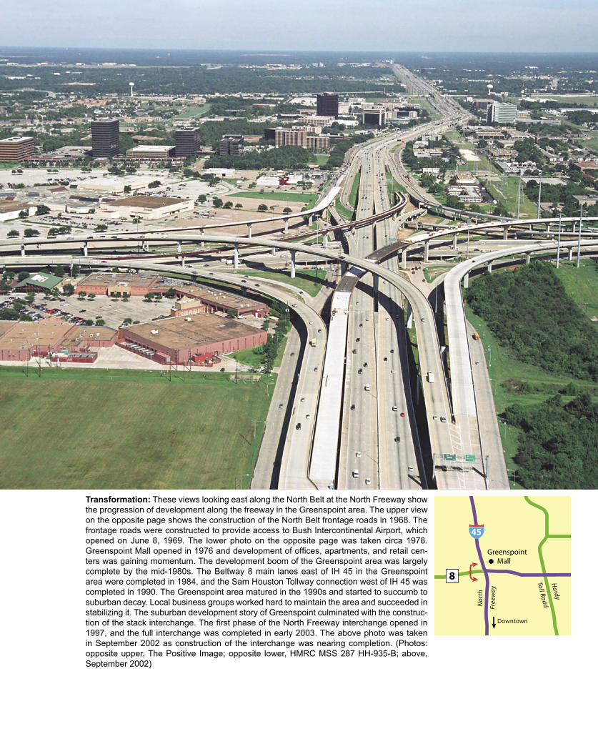
Transformation: These views looking east along the North Belt at the North Freeway show the progression of development along the freeway in the Greenspoint area. The upper view on the opposite page shows the construction of the North Belt frontage roads in 1968. The frontage roads were constructed to provide access to Bush Intercontinental Airport, which opened on June 8, 1969. The lower photo on the opposite page was taken circa 1978. Greenspoint Mall opened in 1976 and development of offices, apartments, and retail cen-ters was gaining momentum. The development boom of the Greenspoint area was largely complete by the mid-1980s. The Beltway 8 main lanes east of IH 45 in the Greenspoint area were completed in 1984, and the Sam Houston Tollway connection west of IH 45 was completed in 1990. The Greenspoint area matured in the 1990s and started to succumb to suburban decay. Local business groups worked hard to maintain the area and succeeded in stabilizing it. The suburban development story of Greenspoint culminated with the construc-tion of the stack interchange. The first phase of the North Freeway interchange opened in 1997, and the full interchange was completed in early 2003. The above photo was taken in September 2002 as construction of the interchange was nearing completion. (Photos: opposite upper, The Positive Image; opposite lower, HMRC MSS 287 HH-935-B; above, September 2002)
�
���������������������
��
�����
�����������
���
�
����
��
�
��������

304 Houston Freeways
$25 million in property within the next few weeks. It was still a challenging task, and one day before a decision had to be made about whether the first contract could be awarded on the agreed-to date, the right-of-way acqui-sition job was not complete. On the decision day at 8:15 A.M., Letz received the final right-of-access needed for the project.
The job would go to bid, and the construction of Beltway 8 West was soon underway.44
The contract award for the short length of frontage roads in west Houston in 1983 marked the beginning of the wave of construction that would build Beltway 8. For 30 years the Beltway had moved forward one inch at a time, and often stood still. But now, TxDOT support
and the newly created Harris County Toll Road Author-ity would push the Beltway into reality over the next 13 years. TxDOT constructed the frontage roads and sections of main lanes on the North Belt and East Belt, as well as most of the interchanges at intersecting freeways. The section of frontage roads included in the Beltway 8 Group funding agreement was opened in December 1985. After that, frontage road sections opened regularly around the Beltway, culminating with the opening of the final section to complete the circular loop in southeast Houston near Hobby Airport in 1996. HCTRA took on the job of build-ing the main lanes as a tollway, with initial work focusing on the West Belt and North Belt.
Sam Houston Tollway, Cash CowProceeding with construction of the Beltway 8 Toll
Road was somewhat of a leap of faith for Harris County Judge Jon Lindsay. Revenue studies had rated it as a mar-
Success: By the late 1990s traffic congestion was a daily occurrence on the West Belt. This view looks north near Kempwood during the afternoon rush hour. The heavy traffic on the Belt-way has been a financial windfall for the Harris County Toll Road Authority, enabling it to expand the toll road system. Projects to expand the West and North sections of the Sam Houston Toll-way, from the Southwest Freeway to the North Freeway, to eight lanes began in 2002 and are scheduled to be complete by 2005. Expansion work in progress can be seen in the distance in this photo (the light-colored concrete). (Photo: September 2002)
��������
���
�
��������
��������������

The Loops 305
ginal, risky project and indicated a strong chance the proj-ect would lose money. The same study predicted that the Hardy Toll Road would be profitable. But Lindsay pushed forward with the Beltway Toll Road. In July 1985 a ground breaking ceremony was held for the construction of the first segment of the tollway from the Southwest Freeway to the Katy Freeway. In 1986 the Beltway was named the Sam Houston Parkway and was designated as a scenic district to prevent the proliferation of billboards along the frontage roads. The tolled main lanes were designated as the Sam Houston Tollway. The Beltway became the first and only limited-access facility within the city of Houston to be named after an individual—the first president of the Republic of Texas and namesake of the city of Houston. The first segment of the Sam Houston Tollway opened on June 29, 1988. The second section, from the Katy Freeway to the Northwest Freeway, opened in June 1989, and the third section, from the Northwest Freeway to the North Freeway, opened in July 1990. The Sam Houston Tollway was unusual for a tollway in that it had continu-ous, toll-free frontage roads for its full length.45
Even before the first section of the Sam Houston Toll-way opened, Harris County officials had substantially lowered traffic and revenue projections. The collapse of Houston’s economy in the mid-1980s and the extended recession through the late 1980s had made the project’s original traffic projections obsolete. By mid-1989, one year after the opening of the first section of the Sam Hous-ton Tollway and the completion of the Hardy Toll Road, toll revenue was less than 50% of original projections. A revised projection predicted that long-term revenue would be 40% less than the original estimates. During 1989 there was frequent talk of the possible need for a subsidy from Harris County’s general tax revenue to meet toll road bond payments. By July 1990, Lindsay was warning that a $20 million annual subsidy from general tax revenue would be needed within two years.46
The third section of the Sam Houston Tollway, from the Northwest Freeway to the North Freeway, opened just as Lindsay delivered the financial bad news. Soon, how-ever, the financial picture began to change. The complete, continuous tollway from Southwest Houston to Bush In-tercontinental Airport caused a surge in traffic. Just three months after section three opened, Harris County officials were stating that a sharp increase in traffic resulting from the completion of section three had postponed the need for a subsidy for at least five years.47
The Sam Houston Tollway traffic boom had begun. Traffic and revenue surged ahead of projections during the 1990s, making the Sam Houston Tollway a cash cow for HCTRA. In the meantime, traffic and revenue on the Hardy Toll Road still lagged behind projections. It turned out that the original traffic projections in 1984, which pre-dicted a successful Hardy Toll Road and a marginal Sam Houston Tollway, had missed the mark on both facilities. But the success of the Sam Houston Tollway allowed HCTRA to easily cover the Hardy Toll Road revenue shortfall.
Key dates in the history of Beltway 8-Sam Houston Tollway1952 The Outer Belt is first proposed, originally as a major
arterial street.1957 The first roads built on the Outer Belt alignment open.1960 The Outer Belt is designated as a freeway. Harris
County takes ownership of the project.1969 The Outer Belt is adopted into the state highway
system and officially named Beltway 8.1970 The first substantial section of the Beltway, a section
of frontage roads, is completed in conjunction with the 1969 opening of Houston Intercontinental Airport.
1976 The Beltway is near death as the 1970s highway funding crisis makes new freeway construction impossible.
1977 The Beltway is restored to long-term plans.1982 The Houston Ship Channel toll bridge is opened on
May 6.1983 Harris county voters approve the creation of the Harris
County Toll Road Authority (HCTRA).1985 In December a section of frontage roads opens in
southwest Houston, launching the wave of construction that would build the Beltway.
1988 The first main lanes built by HCTRA open.1989 Houston’s first five-level stack interchange is completed
at the Katy Freeway.1994 HCTRA takes ownership of the ship channel bridge
from the Texas Turnpike Authority on May 5.1996 The full Beltway is complete, either as a freeway,
tollway, or frontage road.2005 Scheduled completion of expansion to 8 main lanes on
the west and north Sam Houston Tollway.2007 Scheduled completion of the last remaining section of
main lanes in northeast Houston.
Cash cow: This plot shows traffic volume at the busiest point of the Sam Houston Tollway near Westheimer in west Houston.
�
��
���
���
���
���
����������������������������
������������������������������������������������������������������������
���
���
�������
�������������������������
�����������������������������

306 Houston Freeways
Northwest Freeway interchange: This view looks along the southbound Sam Houston Toll-way main lanes. This interchange was completed in 1990. (Photo: May 2003)
Construction: This view looks east along the South Belt at the construction zone for the Gulf Freeway interchange in late 1996. (Photo: Williams Brothers Construction Company)
The Loops 307
In the early 1990s HCTRA Executive Director Wesley Freise and Lindsay were negotiating with the Texas Turn-pike Authority to take over the financially beleaguered Beltway 8 Houston Ship Channel Bridge, which was fac-ing an inevitable default on its bonds in 1996. The bridge transfer to HCTRA occurred on May 5, 1994. As part of the deal, HCTRA received $90 million from TxDOT for the construction of the Sam Houston Tollway between the La Porte Freeway (SH 225) and the Southwest Freeway (US 59), as well as TxDOT’s commitment to build inter-changes at the Southwest and Gulf Freeways estimated to cost $120 million. The southeast section opened in July 1996, the south section opened in March 1997, and the southwest section opened in May 1997. With those open-ings and additional progress on freeway sections of Belt-way 8 in north and northeast Houston, only one section of Beltway 8 did not have its main lanes in place. That sec-tion in northeast Houston, from the Crosby Freeway (US 90) to the Eastex Freeway (US 59), is expected to begin construction in 2005 and be completed in 2007 as a toll-way. Traffic congestion on the west and north Sam Hous-ton Tollway prompted HCTRA to move forward with plans to widen the Sam Houston Tollway to eight main lanes from the Southwest Freeway to the North Freeway. The widening projects began in 2002 and are scheduled to be completed in 2005.
The Airport and the BeltwayThe 1950s was a decade for big infrastructure dreams
to take root. Houston’s freeway system was put on the map in the early 1950s, and the Beltway was first pro-posed in 1952. Another important part of Houston’s trans-portation infrastructure, its major airport, also was taking shape in the 1950s. As initial planning for a major airport took place, one thing became clear: the airport and the Beltway would go hand-in-hand. All potential airport lo-cations were located immediately adjacent to the Beltway, and a site along the North Belt was purchased in 1957 and officially designated for the airport in 1960. The new air-port provided the impetus for the construction of the first significant section of Beltway 8 in 1970—the only sub-stantial section in existence for 12 years until the opening of the Beltway 8 ship channel toll bridge in 1982.
The story of Houston’s major airport is in many ways a contrast to the story of the development of Houston’s free-way network. While local authorities aggressively devel-oped plans for the first-class freeway network in the early 1950s and worked hard to make it happen, the issue of Houston’s airport was plagued by indecision and miscues. With the help of local business interests, the wheels were belatedly set into motion in 1957, and after numerous de-lays the airport finally opened in 1969. Construction and expansion of roads and freeways around the airport played out slowly after the opening of the airport, with significant momentum finally getting underway in the 1980s and ma-jor area-wide construction taking place in the 1990s.
History of Bush Intercontinental AirportToday’s William P. Hobby Airport was the city of
Houston’s first airport, opening in 1937 as Houston Mu-nicipal Airport on the site of a private airfield. By the ear-ly 1950s it became evident that the airport would not be able to meet Houston’s expanding aviation needs. In 1951 the city of Houston contracted for the first study of a sec-ond major airport for Houston. The study—known as the Bourne Study—identified three potential airport sites along the present-day Beltway in northwest Houston. However, no action was taken after the release of the re-port. In the early 1950s the second major airport was still largely in the discussion stage and officials were not ready to commit to the new airport. In the meantime, officials moved forward with the construction of a new terminal at Houston Municipal Airport. The terminal design was de-clared to be inadequate by Houston Mayor Roy Hofheinz during construction, necessitating changes to correct glar-ing problems. Unfortunately, the planning errors in the terminal proved to be somewhat prophetic about the fu-ture of aviation planning in Houston. In October 1954 the new terminal opened and the airport was renamed Hous-ton International Airport.48
Through the mid-1950s the need for a new airport became increasingly urgent, but city officials were slow to take action. In 1957 several events converged to finally move Houston’s second airport forward. While the com-ing of the “jet age” of commercial air service had been anticipated since before 1950, it finally arrived in Houston on May 20, 1957, when a French-built Caravelle jet ar-rived from Miami while on a demonstration tour through the United States. The medium-range, twin-engine Cara-velle had no difficulty with the short 6,565-foot (2,001 m) runway at Houston International, but aviation authorities knew that the runway length would not be adequate for the imminent wave of new jets that would soon arrive from U.S. manufacturers: the Boeing 707, the Douglas DC-8, and the Convair 880. A planned runway extension to 7,300 feet (2,225 m) would be enough to accommodate the new jet aircraft for departures to domestic destina-tions, but still would not be adequate for a jet departing on an overseas flight. It slowly became clear that Houston had underinvested in its aviation facilities and was fall-ing behind the nation’s other major cities in its aviation infrastructure. The Houston Chronicle published a series of articles comparing Houston’s aviation efforts to those of Dallas. The Chronicle concluded that Houston had “stood still” in the preceding years while Dallas had a well-planned program of promoting its aviation activities. Word that Houston is losing ground to its rival Dallas is often enough to spur action.49
The Jet Era Arrives and Becomes the JeteroThe most significant event of 1957, however, was
the action of a group of Houston businessmen who ef-fectively took matters into their own hands to move the second airport forward while local authorities dawdled. The group of businessmen formed an entity called the

308 Houston Freeways
Jet Era Ranch Corporation, which purchased a 3,126-acre tract of land 15 miles (24 km) north of downtown Houston for $1,860,938.27. The group held the property for resale to the city of Houston at the original purchase price for use as the site of Houston’s new airport. The intended name of the land-holding entity—the Jet Era Ranch Corporation—turned out to be short-lived. A secretary’s
typographical error transformed the words “Jet Era” into the single word “Jetero” in an early planning document. From that point on, the airport site became known as the Jetero airport site. The name Jetero would persist until 1983 when it was retired as the name of one of the main entrances to the airport.51
While the land was now in hand, several formalities
The Beltway and the airport—together from the beginning: This 1959 map from the Houston City Planning Depart-ment shows the potential airport sites that were considered. All potential sites were located along the Beltway. The first study for the location for a new airport was conducted in 1951 and identified the three Bourne sites. In 1960 a study de-livered the final site recommendation. The “Bourne West #1” location, the preferred site in 1951, was rejected because of high land cost and flight patterns over newly urbanized areas. The “Bourne North #2” site offered no advantages over the Jetero site but would have been more difficult to acquire. The “Bourne Northwest #3” was rejected because of develop-ment, including a power plant and high voltage lines. The Addicks Reservoir location was rejected due to the high cost to raise the site above flood level, potential compromise of flood control capability, and flight patterns over urbanized areas. The Blue Ridge prison farm site southwest of Houston was determined to be unsuitable for an airport. The winner: the Jetero site.50

The Loops 309
had to be taken care of. In July 1959 Houston voters ap-proved a $50 million bond issue that included $6 million in airport development funds. In April 1960, in response to Mayor Lewis Cutrer’s request for a comprehensive evaluation of all potential airport sites, a report was issued titled Review and Evaluation of Proposed Major Airport Sites to Serve the Houston Area. This report enumerated the known deficiencies of the existing Houston Interna-tional Airport and identified the Jetero airport site as the only suitable candidate for the new airport. The legal agreements to officially accept the Jetero airport site and make final payment of principal and interest were com-pleted in June 1960.
Planning for the Airport and its FreewaysThe first engineering report for the new airport, Plan of
Development, Jetero Intercontinental Airport, was issued in October 1961. The name of the airport site—”Jetero”—was transferred directly into the new airport name. The 1961 document envisioned a single circular-shaped termi-nal with several concourses extending from it. In terms of roadways, the document specified access roads that would be required. Most significant was the call for immediate action to construct the nearby section of the Outer Belt, the present-day Beltway 8.
The second major airport planning document was is-sued in July 1963 and was titled Volume II, Plan of Devel-opment, Terminal Area, Houston Intercontinental Airport. The “Jetero” designation for the airport was gone, but it would find a second life as the name for one of the main entrance roadways to the airport. This second planning document detailed the comprehensive study that had been undertaken in order to determine the best terminal con-figuration for the new airport. Planning officials visited all the major U.S. airports and had extensive consultations with airport authorities. Four terminal concepts were se-lected for detailed study: the mobile lounge, pier, satellite, and unit terminal. The mobile lounge concept, which was in use at Dulles airport near Washington, D.C., featured bus-type vehicles that shuttled passengers between the main terminal and aircraft. The pier concept most closely resembled the original design and featured a central unit for all airline operations with pier structures housing gates radiating from the central unit. The satellite concept also featured a single central unit, but aircraft would be grouped around individual satellite buildings that were connected to the main terminal. The unit terminal concept featured a series of relatively small, stand-alone terminals constructed along a central mall.
The engineers and architects unanimously recom-mended the unit terminal design, mainly because it best met the requirements of flexibility and expandability. In addition, it would distribute traffic among several ter-minals rather than one terminal, and it would avoid the sprawl and long passenger walking distances that would eventually occur in a single-terminal design. Although the unit terminal appeared to be the best design at the time, it would prove to be less than optimal for the airline hub and
spoke operations that would later dictate airport design. The city of Houston adopted the unit terminal design on September 9, 1963.
The next major engineering report, Volume III, Plan of Development, Land Use, Houston Intercontinental Airport, was issued in December 1964. This was the first document to provide details on the two planned entrance roadways, John F. Kennedy Boulevard from the south and Jetero Boulevard on the east. The document specified a 400-foot (122 m) right-of-way to accommodate eventual construction of limited-access main lanes, frontage roads, and mass transit service. Initially, Kennedy Boulevard would be constructed as a four-lane divided roadway and Jetero Boulevard would be constructed as a four-lane di-vided roadway within the airport property and a two-lane roadway between the airport and the Eastex Freeway.
At this point, all the plans were in place to build the airport. In fact, the initial north-south runway was com-pleted in 1964 before any terminal construction. Terminal construction dragged on two years after the scheduled completion date in 1967 because of labor problems that
The jet era becomes Jetero: The site for Bush Intercontinental Air-port was originally purchased by a group of civic-minded Houston businessmen in 1957 to preserve the site until the city of Houston could formulate a plan for a second airport. The holding company for the land was named the Jet Era Ranch Corporation, but a typo-graphical error transformed the words “Jet Era” into “Jetero” and the airport site subsequently became known as the Jetero airport site. Although the name Jetero was no longer used in official plan-ning documents after 1961, the eastern entrance to the airport was named Jetero Boulevard. In 1983, on the recommendation of Houston City Council member Eleanor Tinsley, Jetero Boulevard was renamed Will Clayton Parkway in honor of the cofounder of the Anderson, Clayton & Co. cotton trading firm and undersecretary of state for economic affairs from 1940 to 1948. Tinsley and other political officials felt that the 1950s-sounding name Jetero was not good for Houston’s image. However, nostalgia buffs may have been disappointed. The name Jetero recalled an era when jet travel promised to revolutionize travel opportunities—a time when the roar of a jet engine or a condensation trail in the sky inspired awe. (Photo: Houston Airport System)
310 Houston Freeways
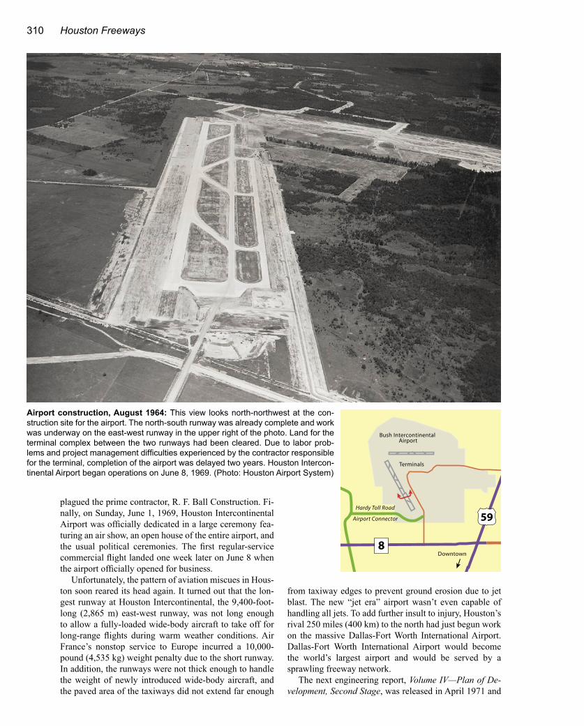
plagued the prime contractor, R. F. Ball Construction. Fi-nally, on Sunday, June 1, 1969, Houston Intercontinental Airport was officially dedicated in a large ceremony fea-turing an air show, an open house of the entire airport, and the usual political ceremonies. The first regular-service commercial flight landed one week later on June 8 when the airport officially opened for business.
Unfortunately, the pattern of aviation miscues in Hous-ton soon reared its head again. It turned out that the lon-gest runway at Houston Intercontinental, the 9,400-foot-long (2,865 m) east-west runway, was not long enough to allow a fully-loaded wide-body aircraft to take off for long-range flights during warm weather conditions. Air France’s nonstop service to Europe incurred a 10,000-pound (4,535 kg) weight penalty due to the short runway. In addition, the runways were not thick enough to handle the weight of newly introduced wide-body aircraft, and the paved area of the taxiways did not extend far enough
from taxiway edges to prevent ground erosion due to jet blast. The new “jet era” airport wasn’t even capable of handling all jets. To add further insult to injury, Houston’s rival 250 miles (400 km) to the north had just begun work on the massive Dallas-Fort Worth International Airport. Dallas-Fort Worth International Airport would become the world’s largest airport and would be served by a sprawling freeway network.
The next engineering report, Volume IV—Plan of De-velopment, Second Stage, was released in April 1971 and
Airport construction, August 1964: This view looks north-northwest at the con-struction site for the airport. The north-south runway was already complete and work was underway on the east-west runway in the upper right of the photo. Land for the terminal complex between the two runways had been cleared. Due to labor prob-lems and project management difficulties experienced by the contractor responsible for the terminal, completion of the airport was delayed two years. Houston Intercon-tinental Airport began operations on June 8, 1969. (Photo: Houston Airport System)
���������
�
���������������
�����������������
�����������������������������
��
��������

The Loops 311
Original JFK Boulevard connection ramps, 1970-1992: This August 1978 view looks west along the North Belt frontage road at the original connection ramps at John F. Kennedy Boule-vard. The ramps were dismantled and replaced in 1992 during the construction of the Beltway main lanes. (Photo: Texas Transportation Institute)
North Belt at JFK Boulevard: This photo shows the same view as the above photo in May 2003.
�
��
��������
����
��������

312 Houston Freeways
focused on correcting the airport’s runway shortcomings as quickly as possible. The 8,000-foot (2,438 m) north-south runway was slated to be lengthened to 12,000 feet (3,657 m). Runways and taxiways would be thickened where necessary. In terms of roadways, the 1971 plan reaffirmed previous plans. The cross section view of the entrance roadways, Kennedy and Jetero Boulevards, now showed a 450-foot-wide (137 m) corridor. The document also included an expanded discussion of mass transit ser-vice to the airport in recognition of the increasingly free-way-hostile climate of the early 1970s and greater interest in mass transit. However, it was recognized that a mass transit system was at least 10 to 15 years in the future.
Perhaps the lowest point in the history of Houston Intercontinental Airport—at least psychologically—oc-curred in the 1970s when Houston was not a hub airport and many travelers were forced to make connections at Dallas-Fort Worth International Airport. For Houstonians, having to connect through Dallas was perhaps the ultimate slap in the face. Attracting a large airline to call Houston its home became a top priority of local officials. The completion of Terminal C in 1981 provided a terminal facility capable of handling a hub operation, and in 1982 Continental Airlines moved its headquarters to Houston. Starting around that time, Continental began building its Houston hub. Finally, Houston Intercontinental Airport had overcome its growing pains and was now positioned to propel itself into the upper tier of U.S. airports.52
The 1990s and 2000s saw ongoing improvements to the airport. In 1990, the International Airlines Terminal Building opened. Later in the 1990s, the circular gate fa-cilities at Terminal A, which had a distinctive 1960s feel and seemed to be reminiscent of the 1950s-sounding term “Jetero,” were demolished and replaced with linear gate facilities. The circular facilities at Terminal B were re-tained, however, even as Continental’s hub operation ex-panded into Terminal B. In May 2002, a 6,000 foot (1,829 m) runway was lengthened to 10,000 feet (3048 m) for
full jet service, and in 2003 an all-new, 9,400-foot (2,865 m) runway opened. With the addition of the new runway, the airport’s land area exceeded 10,000 acres. The first phase of the new Terminal E was dedicated in June 2003.
In 2002, Houston’s Bush Intercontinental Airport ranked as the 8th busiest airport in the United States and the 13th busiest airport in the world as measured by total passengers. It was a remarkable level of success for an airport that had been plagued with so many problems dur-ing its development and was not ideally situated for airline hub operations. To complement its world-class freeway system, Houston also had an airport that reached world-class status.53
The Roads and FreewaysImprovements to the roads and freeways serving Bush
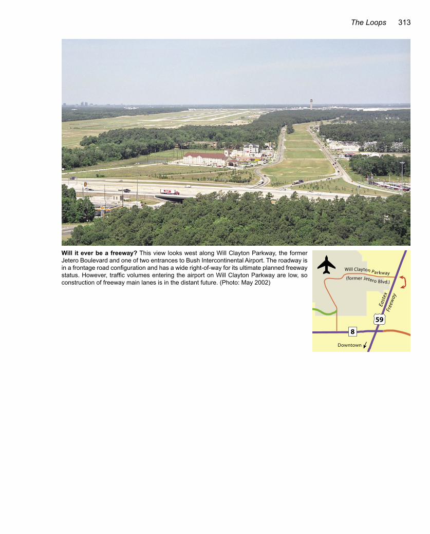
Intercontinental Airport were completed around the time of the airport opening in June 1969. The Eastex Freeway from downtown to the airport entrance was upgraded to full freeway status by 1970. The Beltway 8 frontage roads between the North and Eastex Freeways were opened in February 1970. The North Freeway had been completed in 1963. The southern entrance to the airport, John F. Ken-nedy Boulevard, was a four-lane divided highway, and the eastern entrance to the airport, Will Clayton Parkway, was a four-lane divided highway inside the airport and a two-lane roadway outside the airport. During the 1970s there were almost no freeway or roadway improvements in the vicinity of the airport.
Freeway construction resumed in the mid-1980s. In 1983 work was underway to construct the Beltway 8 main lanes near the airport. The Hardy Toll Road opened in 1987. The 1990s brought a construction boom to air-port-area freeways. The Beltway 8 main lanes between the North and Eastex Freeways were completed in bits and pieces, with the final section at the Eastex Freeway opening in December 2002. A four-level interchange at Kennedy Boulevard with two direct connectors was com-pleted in 1992. Major expansion of the North Freeway west of the airport was completed in 1998. Expansion of the Eastex Freeway was completed in 1999. The Hardy Toll Road airport connector opened in January 2000. The five-level stack interchange at Beltway 8 and the North Freeway saw its first phase open in 1997 and was fully completed in early 2003. The first connector ramp at the interchange of the North Belt and Eastex Freeway opened in December 2002, and the second phase, in progress in 2003, will add three more direct connector ramps.
But what about the entrance roadways to the airport? Will they ever become freeways? In the long run, the answer to that question is probably yes, but in the short and intermediate planning horizons neither John F. Ken-nedy Boulevard nor Will Clayton Parkway will become a freeway. John F. Kennedy Boulevard will be the first to become a full freeway since only one traffic light needs to be eliminated. The lightly-travelled Will Clayton Parkway will probably have to wait a very long time for freeway status.
Key dates in the history of Bush Intercontinental Airport1951 The first study of potential airport sites is completed.1957 Local business leaders purchase the airport site
with a land holding-entity called the Jet Era Ranch Corporation.
1960 Voters approve bonds for the airport.1969 The airport opens on June 8, 1969, after a long delay in
completing the terminal.1981 Terminal C opens, and Continental Airlines begins
building its Houston hub operation.1990 The International Airlines Terminal opens.1997 The airport is renamed George Bush Intercontinental
Airport/Houston, in honor of nation’s 41st president who served from 1989 to 1993.
2002 For passenger traffic, the airport is the 8th busiest in the United States and 13th busiest in the world.
2003 The new $225 million Terminal E opens, with 23 gates.
The Loops 313
Will it ever be a freeway? This view looks west along Will Clayton Parkway, the former Jetero Boulevard and one of two entrances to Bush Intercontinental Airport. The roadway is in a frontage road configuration and has a wide right-of-way for its ultimate planned freeway status. However, traffic volumes entering the airport on Will Clayton Parkway are low, so construction of freeway main lanes is in the distant future. (Photo: May 2002)
���� ������� �������
�
��
��������
������� ������ ������
����
����
���
��