samrand development (pty) ltd c2562/01fs proposed...
TRANSCRIPT

SAMRAND DEVELOPMENT (PTY) LTD
C2562/01FS
PROPOSED FILLING STATION DEVELOPMENT TO BE
LOCATED ON ERVEN 1 AND 2, KOSMOSDAL EXTENSION 104
CENTURION, PRETORIA
FEASIBILITY STUDY
FEBRUARY 2019

REPORT SHEET
PROJECT TITLE: PROPOSED FILLING STATION ON ERVEN 1 AND 2 KOSMOSDAL
EXTENSION 104, CENTURION, PRETORIA
FEASIBILITY STUDY
PREPARED FOR: SAMRAND DEVELOPMENT (PTY) LTD
PREPARED BY: CIVIL CONCEPTS (PTY) LTD
PROJECT TEAM: MM GOUNDEN TRAFFIC ENGINEER
WA KHAN TECHNOLOGIST
Copy Date Done By Checked Approved
V1 DRAFT 1 01/11/2018 WA KHAN MM Gounden MM Gounden
V1 DRAFT 2 05/11/2018 WA KHAN MM Gounden MM Gounden
V1 DRAFT 3 06/01/2019 WA KHAN MM Gounden MM Gounden
V1 19/02/2019 WA KHAN MM Gounden MM Gounden
DECLARATION
I certify that this study has been prepared under my immediate supervision and that I have
experience and training in the field of traffic and transportation engineering.
Signed:
Name: MM Gounden
Qualification: BSc Eng (Civil)
Registration Number: ECSA 2013 0143

TABLE OF CONTENTS
PAGE
EXECUTIVE SUMMARY
1 INTRODUCTION .............................................................................................................. 1
1.1 Background .................................................................................................. 1
1.2 Locality ........................................................................................................ 1
1.3 Methodology ................................................................................................. 2
2 PROPOSED FILLING STATION .......................................................................................... 3
2.1 Access ......................................................................................................... 3
2.2 Services ....................................................................................................... 3
3 IMPACT ON EXISTING SITES ............................................................................................ 4
3.1 Introduction ................................................................................................. 4
3.2 Competitor Sites ............................................................................................ 4
3.3 Catchment Markets ...................................................................................... 11
3.4 Future Development Traffic............................................................................ 11
3.5 Shared Traffic Volumes ................................................................................. 13
3.6 Future Road Network .................................................................................... 15
3.7 Moving Market Factor between Filling Stations ................................................... 15
4 ESTIMATED SALES ........................................................................................................ 17
4.1 Introduction ............................................................................................... 17
4.2 Traffic Demand ........................................................................................... 17
4.3 Average Fill ................................................................................................ 20
4.4 Interception Rate – Passing Traffic .................................................................. 20
4.5 Full Trading Days in a Month .......................................................................... 23
4.6 Expected Monthly Sales ................................................................................. 23
5 FEASIBILITY OF THE PROPOSED FILLING STATION AND IMPACT ON SURROUNDING SITES26
6 OTHER TRAFFIC ENGINEERING CONSIDERATIONS AT A FILLING STATION ..................... 27
6.1 Impact of Traffic Flow past the Site - Road Safety .............................................. 27
6.2 Delivery Path .............................................................................................. 27
7 CONCLUSIONS AND RECOMMENDATIONS ...................................................................... 28
7.1 Conclusions ................................................................................................ 28
7.2 Recommendations ....................................................................................... 28

REFERENCES
ANNEXURES
ANNEXURE A - LOCATIONS OF ADJACENT FILLING STATIONS WITHIN A 3.5 km
RADIUS
ANNEXURE B - SITE LAYOUT PLAN
ANNEXURE C - TRAFFIC COUNT SURVEY DATA
ANNEXURE D - SURVEY SHEETS
ANNEXURE E - INTERCEPTION RATES GRAPH 6.2
EXECUTIVE SUMMARY
This report analysed the feasibility of a proposed filling station on Erven 1 & 2 Kosmosdal Extension
102, Centurion, Pretoria. The proposed filling station will be located in the north-western quadrant of
the Samrand Avenue / Rooihuiskraal Road (M37) junction. Calculations showed that the proposed
development site is expected to pump out approximately 612 130 litres of fuel per month in its first
year (2020), based on passing traffic volumes and the average fill per vehicle of its nearby competitors.
The proposed filling station development will be serviced by two (2) accesses:
A proposed marginal access (left-in, left-out only) off Samrand Avenue, the minimum distance
from the centre line Samrand Avenue / Rooihuiskraal Road (M37) intersection to the bell mouth
of left-in, left-out access will be 100m; and
a second access to the proposed filling station will be provided as a full access off Rooihuiskraal
Road (M37) at a distance of approximately 100m from the centre line Samrand Avenue /
Rooihuiskraal Road (M37) intersection to the bell mouth of full access.
This feasibility study was done by assessing the impact of the proposed filling station on nearby filling
stations. The effect that the proposed filling station will have on the existing filling stations within a 3.5
km radius were considered. There are six (6) filling stations that fall within the 3.5 km radius and it was
found that only one (1) of the existing filling station could be considered as competitor site. The other
filling stations will not share traffic with the proposed development site due to physical barriers
preventing traffic from travelling along the same routes to their origin-destination.
The sales at the one (1) competitor site may decrease by a small margin as the proposed filling station
may attract some of the customers from the existing filling station.
The proposed filling station will generate a negligible number of new trips as a filling station is generally
not a trip attractor.
Samrand Phase 3 (Kosmosdal Extension 92) is a proposed mixed-use development taking place in the
area that will consist of industrial park, offices and multi-level town houses. The proposed development
will increase traffic volumes in the area over time, especially along Rooihuiskraal Road (M37) and
Samrand Avenue, and will create a need for a new filling station in the area.
In future, there will be changes to the road network. These changes include the extension of Samrand
Avenue and Rietspruit Road westwards to intersect with future K71 and K73. There are planned
provincial roads (K54 & K71) to west of the proposed development site and both runs in a north-south
direction. These roads will intersect with the extension of Rietspruit Road and the extension of Samrand
Avenue.
1
1 INTRODUCTION
1.1 Background
Civil Concepts (Pty) Ltd was appointed by Samrand Development (Pty) Ltd to prepare a
Feasibility Study (FS) for a proposed filling station development to be located in the north-
western quadrant of the Samrand Avenue / Rooihuiskraal Road (M37) junction, on Erven 1 &
2 Kosmosdal Extension 102, Centurion, Pretoria.
The anticipated opening year of the proposed filling station is 2020.
The objective of this study is to determine the feasibility of locating a filling station on the
subject site and to estimate the impact that the proposed filling station will have on the
surrounding filling stations.
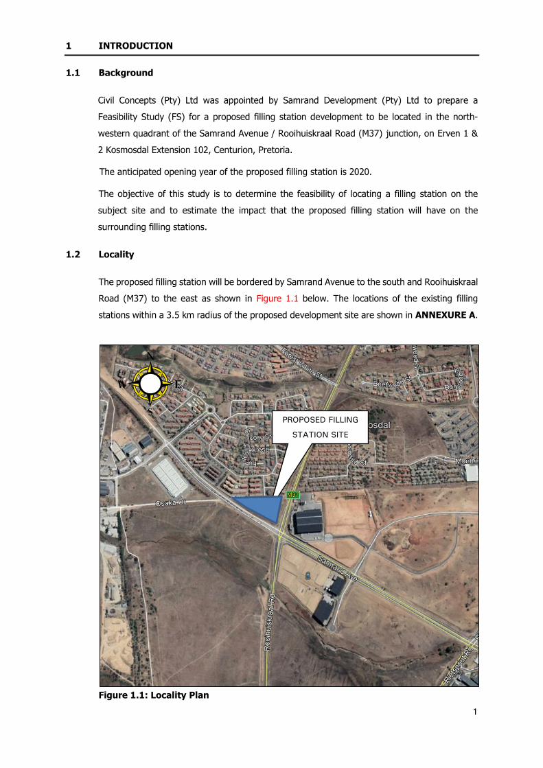
1.2 Locality
The proposed filling station will be bordered by Samrand Avenue to the south and Rooihuiskraal
Road (M37) to the east as shown in Figure 1.1 below. The locations of the existing filling
stations within a 3.5 km radius of the proposed development site are shown in ANNEXURE A.
Figure 1.1: Locality Plan
PROPOSED FILLING
STATION SITE

2
1.3 Methodology
A feasibility study has to take the future income, accessibility, and its impact on surrounding
filling stations into consideration.
The following methodology has been used in the feasibility study:
1. Assess the impact of the proposed filling station on nearby filling stations;
2. Estimate sales of the proposed filling station using traffic count data and data from nearby
filling stations;
3. Consider the feasibility of the site in terms of access to the site and impact of the
development on the surrounding road network; and
4. Recommendations on the feasibility of the proposed filling station.

3
2 PROPOSED FILLING STATION
2.1 Access
The proposed filling station development will be serviced by two (2) accesses. A proposed
marginal access (left-in, left-out only) off Samrand Avenue and a proposed full access off
Rooihuiskraal Road (M37). The proposed accesses to the filling station are positioned in
accordance with the City Council of Pretoria’s “Guidelines for Access to Filling Stations in the
Greater Pretoria Area (First Revision), March 2001” (refer to ANNEXURE B for the site layout
plan).
2.1.1 Marginal Access off Samrand Avenue
As per the Guidelines for Access to Filling Stations in the Greater Pretoria Area (First Revision),
March 2001, Figure C2, a minimum of 30m from the preceding/following intersection to the
access to the filling station on Samrand Avenue is required for a design speed of 60 km/h. Only
vehicles travelling eastbound will be able to enter the proposed filling station via this access.
It is therefore concluded that the access to the site is well positioned at a distance of
approximately 100m from the preceding/following intersection to the access to the filling station
on Samrand Avenue and meets the minimum requirements as set out in the “Guidelines for
Access to Filling Stations in the Greater Pretoria Area (First Revision), March 2001”.
2.1.1 Full Access off Rooihuiskraal Road (M37)
As per the Guidelines for Access to Filling Stations in the Greater Pretoria Area (First Revision),
March 2001, Figure C5 a minimum of 30m from the preceding/following intersection to the
access to the filling station on Rooihuiskraal Road (M37) is required for a design speed of
60 km/h. Vehicles travelling northbound and southbound will be able to enter the proposed
filling station via this access.
It is therefore concluded that the access to the site is well positioned at a distance of
approximately 100m from the preceding/following intersection to the access to the filling station
on Rooihuiskraal Road (M37) and meets the minimum requirements as set out in the “Guidelines
for Access to Filling Stations in the Greater Pretoria Area (First Revision), March 2001”.
2.2 Services
The proposed development will provide the following services:
Filling station;
Convenience shop;
Drive through;
Fast food;
Car wash; and
ATM facility.
4
3 IMPACT ON EXISTING SITES
3.1 Introduction
The Gauteng Department of Agriculture and Rural Development (GDARD) requires that the
impact on all filling station sites within a 3.5 km radius be determined. The proposed
development site is located in an area with six (6) competitors, with the nearest competitor
being approximately 1 km from the subject site.
3.2 Competitor Sites
3.2.1 Introduction
The competitor sites are located within the Kosmosdal, Olievenhoutbosch, Reeds and Noordwyk
area (refer to ANNEXURE A). The quality of the competitors’ facilities are generally average
and all the sites are doing fairly well. The competitor sites mainly serve the respective areas in
which they are located. It is therefore highly unlikely that the proposed filling station will have
a negative impact on a vast majority of its competitors.
The six (6) surveyed sites within 3.5 km are described below.

5
3.2.2 Engen Noordwyk Service Station ≈ 3.60 km south of the subject site (Figure 3.1)
The site is located along Lever Road, in the Noordwyk area. The site has two accesses, one
access is obtained via marginal access (left-in, left-out), off Lever Road southbound (a class 3
road) whereas the second access is a full access off Coubrough Road (a class 4 road). The site
has an Engen Quick Stop C-store and corner bakery. There is an ABSA ATM and a car wash at
the site. This service station has good visibility and accessibility for southbound traffic on Lever
Road and eastbound-westbound traffic on Coubrough Road. NOT CONSIDERED A
COMPETITOR SITE.
Figure 3.1: Engen Noordwyk Service Station (East of Lever Road)

6
3.2.3 Engen Country View Service Station ≈ 3.0 km south of the subject site (Figure 3.2)
The site is located in the north-western quadrant of the Lever Road / Azalea Avenue junction.
The site is serviced with two full accesses. One full access is off Lever Road (a class 3 road)
and the second full access is via Azalea Avenue (a class 4 road). The site has an Engen Quick
Stop C-store and corner bakery. There is a Standard Bank ATM and a car wash at the site. The
site has good visibility and accessibility for northbound-southbound traffic on Lever Road, and
also eastbound-westbound traffic on Azalea Avenue. NOT CONSIDERED A COMPETITOR
SITE.
Figure 3.2: Engen County View Service Station (West of Lever Road)

7
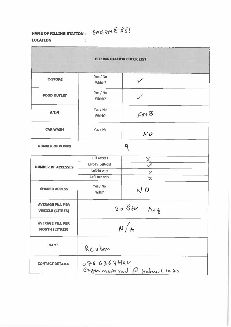
3.2.4 Engen Olievenhoutbosch Service Station ≈ 3.50 km west of the subject site (Figure 3.3)
The site is located along R55 (K71), in the Olievenhoutbosch area. It is bordered by R55 (K71)
to the west. Access to the site is obtained via a marginal access (left-in, left-out) off R55 (K71).
The site has Engen Quick Stop C-store, a corner bakery and FNB ATM. The site has good
visibility and accessibility for the northbound traffic on R55 (K71). NOT CONSIDERED A
COMPETITOR SITE.
Figure 3.3: Engen Olievenhoutbosch Service Station (West of R55 (K71))

8
3.2.5 Engen Reeds Service Station ≈ 3.10 km north of the subject site (Figure 3.4)
The site is located along Panorama Road. It is bordered by the Panorama Road to the north
and Marquard Street to the west. The site has three full accesses, two full accesses are off
Panorama Road (a class 4 road) and one full access is obtained via Marquard Street (a class 5
road). The site intercepts eastbound-westbound traffic on Panorama Road. The site has good
visibility and is easily accessible. The site has Engen Quick Stop C-store, a corner bakery and
Capitech Bank ATM. NOT CONSIDERED A COMPETITOR SITE.
Figure 3.4: Engen Reeds Service Station (South of Panorama Road)

9
3.2.6 Sasol R101 Service Station ≈ 3.40 km north-east of the subject site (Figure 3.5)
The site is located along the Old Johannesburg Road R101 (K101), in the Rooihusiskraal area.
Old Johannesburg Road R101 (K101) (a class 2 road) runs in a north-south direction. The site
is serviced with one marginal (left-in, left-out only) access off Old Johannesburg Road R101
(K101). The site has a Sasol Delight C-store, and an ABSA ATM. NOT CONSIDERED A
COMPETITOR SITE.
Figure 3.5: Sasol R101 Service Station (West of Old Johannesburg Road)

10
3.2.7 Shell Samrand Service Station ≈ 1.0 km east of the subject site (Figure 3.6)
The site is located in the south-eastern quadrant of Samrand Avenue / Rietspruit Road junction.
It is bordered by Samrand Avenue (a class 3 road) to the north and Rietspruit Road (class 4
road) to the west. The filling station has two access point, a marginal (left-in, left-out only)
access with a median island off Samrand Avenue and a partial access (left-in, left-out and right-
in) off Rietspruit Road. The site has Shell Select C-store and an ABSA Bank ATM. The site has
good visibility and accessibility for westbound traffic on Samrand Avenue and also northbound-
southbound traffic on Rietspruit Road. CONSIDERED A COMPETITOR SITE.
Figure 3.6: Shell Samrand Service Station (South of Samrand Avenue)

11
3.3 Catchment Markets
The catchment area is defined as the main area from which customers to the filling station will
be coming from. The catchment area for the proposed development site has been identified
as:
1. Transient traffic on Samrand Avenue eastbound;
2. Transient traffic on Rooihuiskraal Road (M37) northbound and southbound;
3. Some of local traffic of the Kosmosdal area.
3.4 Future Development Traffic
3.4.1 Introduction
The proposed filling station will generate a negligible number of new trips as in general a
filling station is not a trip generator. A proposed mixed-use Samrand Phase 3 (Kosmosdal
Extension 92) development is taking place in the area that will consist of industrial park,
offices and multi-level town houses.
3.4.2 Samrand Phase 3 Development (Kosmosdal Extension 92)
The Traffic Impact Assessment in support of the proposed mixed-use development to be
located on the Remainder of Portion 2 of the Farm Olievenhoutbosch 389-JR, Samrand Phase
3 (Kosmosdal Extension 92), dated May 2016, ref:C2033/02TIS2 was done by Civil Concepts
(Pty) Ltd.
The proposed development will be located in the south-western quadrant of the Rooihuiskraal
Road / Samrand Avenue junction and is bordered by Rietspruit Road to the south as shown in
Figure 3.7.

12
Figure 3.7: Proposed Samrand Phase 3 (Kosmosdal Extension 92) Development
The proposed land-use rights for the Samrand Phase 3 development is provided in Table 3.1
below.
TABLE 3.1: PROPOSED LAND-USE RIGHTS – SAMRAND PHASE 3
Area Land-use Extent Daily Rates
Kosmosdal Extension 92
“Residential 3” 621 units 3.25
Offices 10 906 m2 8.50
Industrial Park 1 232 008 m2 6.00
Industrial Park 2 208 596 m2 6.00
The development is expected to be completed by 2028.
The future development traffic of the Samrand Phase 3 development on the Samrand Avenue
/ Rooihuiskraal Road (M37) junction is shown in Table 3.2.
PROPOSED FILLING
STATION SITE

13
TABLE 3.2: PROPOSED SAMRAND PHASE 3 DEVELOPMENT AADT
Road AADT (veh/day)
Samrand Avenue Eastbound 4 439
Samrand Avenue Westbound 1 645
Rooihuiskraal Road (M37) Northbound 3 498
Rooihuiskraal Road (M37) Southbound 3 248
3.5 Shared Traffic Volumes
3.5.1 Introduction
Due to the location of the proposed filling station, certain streams and hence volumes of passing
traffic will be shared amongst the proposed and existing filling stations.
The results of the analysis took into account the Average Annual Daily Traffic (AADT) of streams
of traffic directly shared by the proposed and existing stations if the proposed filling station
intercepts traffic before its competitors.
The proposed filling station will only share a negligible number of trips with the one (1) filling
station, which is discussed below.
3.5.2 Filling Stations with Shared Traffic
Shell Samrand Service Station
The site is located in the south-eastern quadrant of Samrand Avenue / Rietspruit Road junction.
It is bordered by Samrand Avenue to the north and Rietspruit Road to the west. A small portion
of westbound traffic on Samrand Avenue turning right into Rooihuiskraal Road (M37) is
expected to be shared with the proposed filling station. This volume is expected to be low since
the westbound traffic along Samrand Avenue turning right into Rooihuiskraal will be intercepted
first by the Shell Samrand filling station, and then only by the proposed filling station.
3.5.3 Filling Stations without Shared Traffic
The filling stations mentioned in this section will either have the opportunity to intercept traffic
before the proposed filling station or the amount of shared traffic between the existing and
proposed filling stations will be negligible, because traffic will have to divert from their route
towards their origin-destination to access the proposed filling station.

14
Engen Noordwyk Service Station
The site is located along Lever Road, in the Noordwyk area (3.60 km south of proposed filling
station site), therefore it is considered highly unlikely that traffic will divert from there to the
proposed filling station since traffic will have to divert from their route towards their origin-
destination This filling station mainly services residents of Noordwyk.
Engen Country View Service Station
The site is located in the north-western quadrant of the Lever Road / Azalea Avenue junction.
It is bordered by Lever Road to the east. It is considered highly unlikely that traffic will divert
from there to the proposed filling station since traffic will have to divert from their route towards
their origin-destination. This filling station mainly services residents of Country View and
Noordwyk area.
Engen Olievenhoutbosch Service Station
The site is located along R55 (K71), in the Olievenhoutbosch area. It is bordered by R55 (K71)
to the west. It is considered highly unlikely that traffic will be shared between the existing filling
station and proposed filling station since the Engen Olievenhoutbosch filling station serves the
transient traffic on R55 (K71) and traffic will have to divert from their route towards their origin-
destination to get to the proposed filling station.
Engen Reeds Filling Station
The site is located along Panorama Road. It is bordered by the Panorama Road to the north
and Marquard Street to the west. It is considered highly unlikely that traffic will divert from
there to the proposed filling station since traffic will have to divert from their route towards
their origin-destination.
Sasol R101 Service Station
The site is located along the Old Johannesburg Road R101 (K101), in the Rooihusiskraal area.
It is considered highly unlikely that traffic will divert from there to the proposed filling station
since traffic will have to divert from their route towards their origin-destination.

15
3.6 Future Road Network
In future, there will be changes to the road network as indicated in the Figure 3.8. These
changes include the extension of the Rietspruit Road and Samrand to intersect with future K71
and K73, respectively. There are planned provincial roads (K54 and K71) to the west of the
proposed development site and both runs in a north-south direction. These roads will intersect
with the extension of Rietspruit Road and the extension of Samrand Avenue.
Figure 3.8: Future Road Network
3.7 Moving Market Factor between Filling Stations
3.7.1 Introduction
The proposed filling station will have an effect on the current market share of customers at the
closest filling stations. The moving market factor is influenced by how the new site compares
with its competitors. The following factors are taken into account:
Convenience (clean facility and easily accessible);
Visibility (adequate time to decide whether to use the facility or not);
Service provided to public (car wash, convenience shop, ATM etc);
Good access/egress (proper deceleration and acceleration lanes, i.e. easy to merge with
or diverge from through traffic);
Rewards programme offered by filling station in partnership with banks; and
PROPOSED FILLING
STATION SITE

16
Site layout (large enough to have proper site circulation).
Limited information is available regarding the percentage of vehicles that will move away from
competitors to the proposed filling stations. Table 3.3 was used as a guide to determine the
moving market factor.
TABLE 3.3: MOVING MARKET FACTOR
Description Moving Market
Factor (%)
New filling station is better located with good accesses and more facilities, located along same route as competitors
20 – 40
Location, access and facilities are the same as those in the area 10 - 20
New site has poor access, OR no additional facilities, OR located
far away from the existing filling stations. Typically for sites not located in the same market or transient route as the proposed
site.
0 - 10
It should be noted that there is no relationship between shared traffic volumes and the moving
market factor.
3.7.2 Moving Market Factor Competitor Sites
At only one competitor site, a moving market factor as a percentage was applied to estimate
the loss of sales due to the proposed new filling station, is explained below.
Shell Samrand Service Station
The site is located in the south-eastern quadrant of Samrand Avenue / Rietspruit Road junction.
It is bordered by Samrand Avenue to the north and Rietspruit Road to the west. It is estimated
that a negligible amount of the sales of the westbound traffic on Samrand Avenue turning right
into Rooihuiskraal Road (M37) will be lost to the proposed filling station. Therefore a 3% Moving
Market Factor has been assumed.
3.7.3 Estimated Loss of Sales
Tables 3.4 summarises the impact of the proposed site on the existing site.
TABLE 3.4: IMPACT ON SURROUNDING SITES
Site Filling Station
Present Estimated Fuel Sale Potential
(LPM)
Moving Market
Factor (%)
Lost Fuel Sales Due
to Proposed
Sites (LPM)
(Present Fuel Sales – Lost Fuel)
(LPM)
5 Year Future Sales
1 Shell Samrand
Service Station 728 000 3 21 840 706 160 818 633
17
4 ESTIMATED SALES
4.1 Introduction
The empiric formula used by the fuel industry to calculate the expected average litres of fuel
to be sold in a month is:
Litres per month = Vehicles per day X
Average fill per vehicle X
Percentage vehicles of passer-by traffic turning into site X
Average full normal trading days in a month.
Fuel sales at the proposed filling station will include sales lost by competing filling stations and
new sales derived from transient and local traffic that normally fill elsewhere outside the 3.5km
radial area.
It has been established that there is a relationship between the fuel sales and sales in the
convenience shop. The fuel and shop sales are used as the basis to determine whether a site
will be feasible or not.
4.2 Traffic Demand
4.2.1 Existing Traffic Demand
A weekday 24-hour traffic count survey was conducted on 9 October 2018 at the Samrand
Avenue / Rooihuiskraal Road (M37) junction. The traffic count survey data is included in
ANNEXURE C.
The AADT past the subject site is shown in Table 4.1 below.
TABLE 4.1: 2018 AADT PAST THE SITE
Road Name ADT
Samrand Avenue Eastbound 6 273 Veh /24h
Samrand Avenue Westbound 3 523 Veh /24h
Rooihuiskraal Road (M37) Northbound 7 873 Veh / 24h
Rooihuiskraal Road (M37) Southbound 3 965 Veh / 24h
4.2.2 Traffic Growth
The proposed development site is located in rapidly growing area in terms of traffic growth. A
traffic growth rate of 3 % per annum was therefore assumed. This growth rate is considered
as being conservative.

18
4.2.3 Future Traffic Demand
The proposed filling station will generate a negligible number of new trips because a filling
station is not a trip attractor. However, other developments are currently taking place in the
area and are discussed further below (refer to Figure 3.7 for the location of the future Samrand
Phase 3 Developments).
No information was available when these developments will be developed or occupied. It might
take 10 or more years for these developments to be fully developed or occupied. It is therefore
assumed that the developments will be developed or phased over 9 years as shown in Table
4.2 below.
TABLE 4.2: PHASING APPROACH OF THE FUTURE DEVELOPMENTS (ASSUMPTION)
Year Percentage of Development
2020 None
2022 30% of the mentioned future developments will be developed and AADT
on the road network
2024 60%
2026 90%
2028 100% (all latent rights will be fully developed)
The Annual Average Daily Traffic (AADT) to be generated by the proposed developments have
been determined using the daily trip generation rates and parameters prescribed in Committee
of Transport Officials (COTO’s TMH – 17) “South African Trip Data Manual (Version 1.01),
September 2013”.
An annual growth rate of 3% per annum over eight (8) years was used. The future AADT past
the subject site is summarised in Table 4.3.
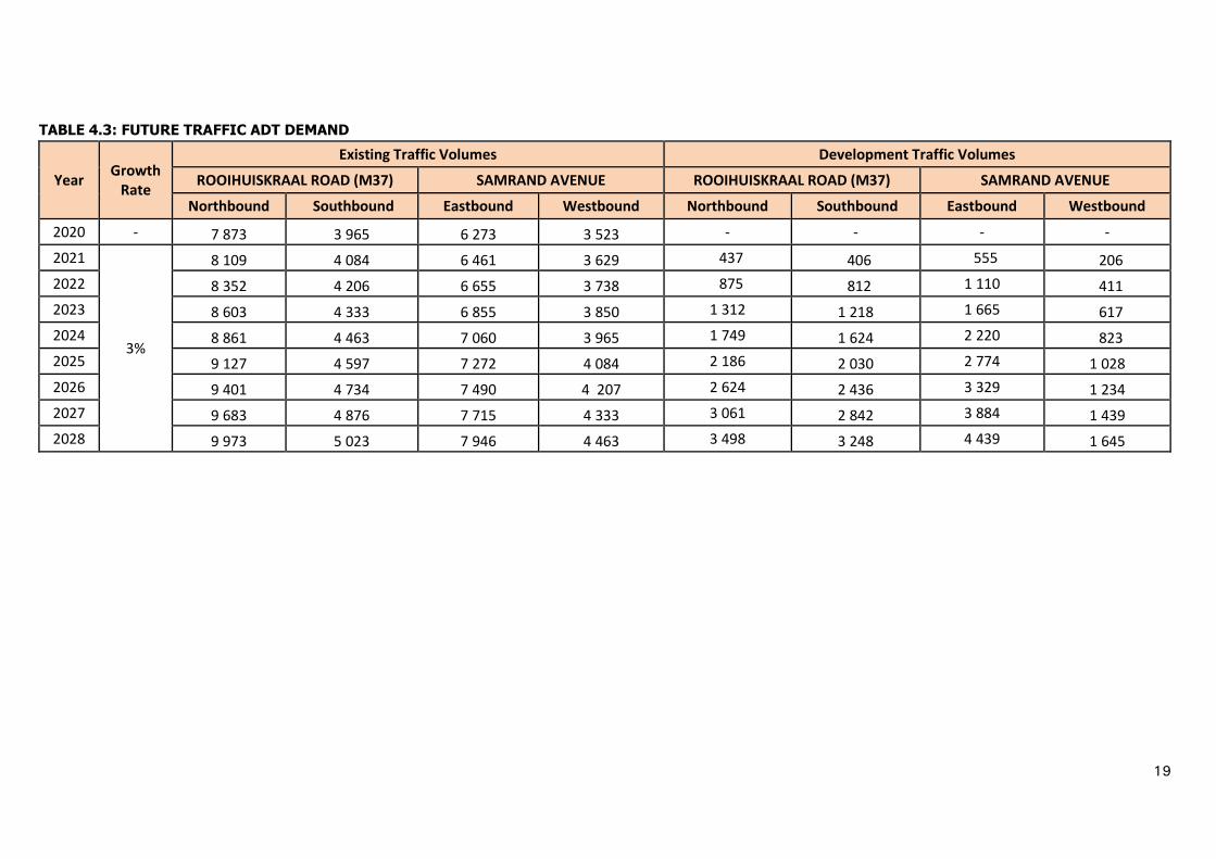
19
TABLE 4.3: FUTURE TRAFFIC ADT DEMAND
Year Growth
Rate
Existing Traffic Volumes Development Traffic Volumes
ROOIHUISKRAAL ROAD (M37) SAMRAND AVENUE ROOIHUISKRAAL ROAD (M37) SAMRAND AVENUE
Northbound Southbound Eastbound Westbound Northbound Southbound Eastbound Westbound
2020 - 7 873 3 965 6 273 3 523 - - - -
2021
3%
8 109 4 084 6 461 3 629 437 406 555 206
2022 8 352 4 206 6 655 3 738 875 812 1 110 411
2023 8 603 4 333 6 855 3 850 1 312 1 218 1 665 617
2024 8 861 4 463 7 060 3 965 1 749 1 624 2 220 823
2025 9 127 4 597 7 272 4 084 2 186 2 030 2 774 1 028
2026 9 401 4 734 7 490 4 207 2 624 2 436 3 329 1 234
2027 9 683 4 876 7 715 4 333 3 061 2 842 3 884 1 439
2028 9 973 5 023 7 946 4 463 3 498 3 248 4 439 1 645

20
4.3 Average Fill
The average fill per vehicle, facilities provided and current monthly sales at the various filling
station sites within a 3.5 km radius were surveyed on 04 September 2018. The average fill of
filling stations within 3.5 km radius is shown in Table 4.4 below (refer to ANNEXURE D for
the survey sheets).
TABLE 4.4 – AVERAGE FILL OF ADJACENT FILLING STATIONS
SITE NAME C-STORE FOOD
OUTLET ATM
AVERAGE
FILL/VEHICLE
(LITRES)
CURRENT
MONTHLY
SALES
(LITRES)
1 Engen Noordwyk Yes No Yes,
1 inside 20 440 000
2 Engen Country
View Yes No
Yes,
1 inside 15 250 000
3 Engen
Olievenhoutbosch
Yes
No Yes,
1 inside 20
Information Unavailable
4 Engen Reeds Yes No Yes,
1 inside 25 380 000
5 Sasol R101 Yes No Yes,
1 inside 25 456 000
6 Shell Samrand Yes No
Yes,
2 inside
and 1
outside
24 728 000
Using the information available, it is assumed that the proposed filling station will have an
average fill of approximately 25 litres.
4.4 Interception Rate – Passing Traffic
The interception rate for passing traffic (turn-in percentage) is determined by the following
factors:
Convenience (clean new facility and easily accessible);
Visibility (adequate time to decide whether to use the facility or not);
The amount of passer-by traffic (fixed, as per traffic count);
Type of traffic (Transient, commuter and residential);
Other nearby filling stations;
Service provided to public (car wash, convenience shop, ATM etc);
Good access/egress (proper deceleration and acceleration lanes);

21
Rewards programme offered by filling station in partnership with banks;
Location (home bound and work bound); and
Site layout (large enough to have proper site circulation).
The interception rate for passing traffic at the proposed facility has been estimated using
Graph 6.2 from the City Council of Pretoria’s “Guidelines for Access to Filling Stations in the
Greater Pretoria Area (First Revision), March 2001.” Graph 6.2 is included in ANNEXURE
E.
These interception rates are considered as being conservative and will most likely be higher. The
passing traffic volumes (existing and the future developments) interception rates are shown in
Table 4.5.

22
TABLE 4.5: PASSING TRAFFIC (ADT) INTERCEPTION RATE (IR)
Existing and Development Traffic Volumes
Year ROOIHUISKRAAL ROAD (M37) SAMRAND AVENUE
Northbound IR% Southbound IR% Eastbound IR% Westbound IR%
2020 8 310 4.12 4 371 5.47 6 828 4.58 3 729 5.73
2021 8 546 4.05 4 490 5.42 7 016 4.52 3 834 5.68
2022 9 227 3.86 5 018 5.22 7 765 4.28 4 149 5.56
2023 9 915 3.67 5 551 5.02 8 519 4.06 4 467 5.43
2024 10 610 3.49 6 087 4.83 9 280 3.84 4 788 5.31
2025 11 313 3.32 6 627 4.65 10 047 3.64 5 112 5.19
2026 12 024 3.15 7 170 4.47 10 820 3.44 5 440 5.06
2027 12 744 2.99 7 718 4.30 11 599 3.25 5 772 4.94
2028 13 471 2.84 8 271 4.13 12 385 3.07 6 108 4.83

23
4.5 Full Trading Days in a Month
The definition of full normal trading days in a month is the number of typical weekday sales in a
month. A typical weekday is a Tuesday, Wednesday or a Thursday during a week with no public
holidays. If there was no variation in the traffic there would have been 30.5 (365 days/12
months) full trading days in a month.
If for example the weekend traffic demand is lower than during the week, the full normal trading
days in a month become less. The traffic surveys were done during a normal week. To allow for
higher Friday volumes and the lower Saturday afternoon, Sunday and holiday volumes, 26 full
trading days in a month are used.
4.6 Expected Monthly Sales
4.6.1 Fuel Sales for Passing Traffic
The expected monthly fuel sales for the subject site using the passing traffic is summarised in
Table 4.6 below.
The opening year (2020) potential average fill was escalated at 3% annual growth over 9 years
to determine the average fills for year 2020 to 2028, respectively.
The expected sales for the subject site were calculated by using the AADT past the site.
Development trips to be generated by the surrounding Samrand Phase 3 development were
taken into account. The expected monthly sales of the proposed filling station may increase in
future, once Samrand Avenue and Rietspruit Road are extended westwards to intersect with
future K71 and K73.
A filling station only realises its full potential in year three after opening. Therefore only 85%
and 95% of the full potential monthly sales was assumed in 2020 and 2021, respectively.

24
TABLE 4.6 – EXPECTED SALES DERIVED FROM PASSING TRAFFIC INCLUDING
DEVELOPMENTS
Year Percentage of Potential
Road Name Proposed
Site Passing Traffic
Litres per Month
Total litres per Month
2020 85%
ROOIHUISKRAAL ROAD (M37)
SB 4371 132 085
612 130 NB 8310 189 144
SAMRAND AVENUE
EB 6828 172 897
WB 3729 118 004
2021 95%
ROOIHUISKRAAL ROAD (M37)
SB 4490 134 524
621 468 NB 8546 191 242
SAMRAND AVENUE
EB 7016 175 273
WB 3834 120 429
2022 100%
ROOIHUISKRAAL ROAD (M37)
SB 5018 144 748
652 547 NB 9227 196 604
SAMRAND AVENUE
EB 7765 183 803
WB 4149 127 391
2023 100%
ROOIHUISKRAAL ROAD (M37)
SB 5551 154 084
680 199 NB 9915 201 059
SAMRAND AVENUE
EB 8519 191 008
WB 4467 134 048
2024 100%
ROOIHUISKRAAL ROAD (M37)
SB 6087 162 570
704 614 NB 10610 204 660
SAMRAND AVENUE
EB 9280 196 980
WB 4788 140 403
2025 100%
ROOIHUISKRAAL ROAD (M37)
SB 6627 170 247
725 974 NB 11313 207 457
SAMRAND AVENUE
EB 10047 201 809
WB 5112 146 461
2026 100%
ROOIHUISKRAAL ROAD (M37)
SB 7170 177 150
744 453 NB 12024 209 499
SAMRAND AVENUE
EB 10820 205 578
WB 5440 152 226
2027 100%
ROOIHUISKRAAL ROAD (M37)
SB 7718 183 317
760 218 NB 12744 210 832
SAMRAND AVENUE
EB 11599 208 369
WB 5772 157 700
2028 100%
ROOIHUISKRAAL ROAD (M37)
SB 8271 188 781
773 428 NB 13471 211 503
SAMRAND AVENUE
EB 12385 210 256
WB 6108 162 888
Legend:
NB – Northbound;
SB – Southbound; EB – Eastbound; and
WB – Westbound.
25
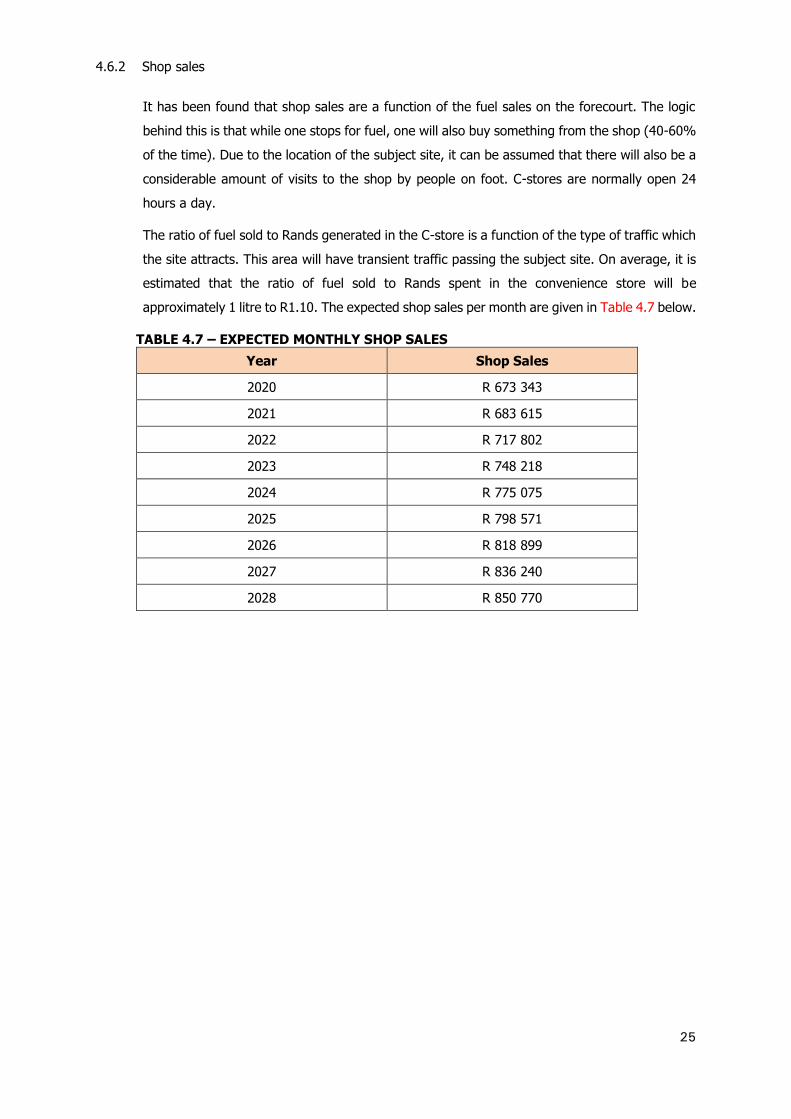
4.6.2 Shop sales
It has been found that shop sales are a function of the fuel sales on the forecourt. The logic
behind this is that while one stops for fuel, one will also buy something from the shop (40-60%
of the time). Due to the location of the subject site, it can be assumed that there will also be a
considerable amount of visits to the shop by people on foot. C-stores are normally open 24
hours a day.
The ratio of fuel sold to Rands generated in the C-store is a function of the type of traffic which
the site attracts. This area will have transient traffic passing the subject site. On average, it is
estimated that the ratio of fuel sold to Rands spent in the convenience store will be
approximately 1 litre to R1.10. The expected shop sales per month are given in Table 4.7 below.
TABLE 4.7 – EXPECTED MONTHLY SHOP SALES
Year Shop Sales
2020 R 673 343
2021 R 683 615
2022 R 717 802
2023 R 748 218
2024 R 775 075
2025 R 798 571
2026 R 818 899
2027 R 836 240
2028 R 850 770

26
5 FEASIBILITY OF THE PROPOSED FILLING STATION AND IMPACT ON
SURROUNDING SITES
The potential income of the proposed filling station was determined in Section 4. The cost of
the filling station, canopy and forecourt is very similar from site to site. The difference in cost
lies in the land value and the cost of the civil engineering works such as the bulk earthworks
and access construction.
Due to the average fill per litres of the nearby filling stations, the total current monthly potential
fill at the proposed filling stations is in line with filling stations in similar locations.
The site is located in a favourable position along a busy Samrand Avenue and Rooihuiskraal
Road (M37), within an area with rapidly growing traffic and without much competition from
nearby filling stations.
It is evident that the subject site is feasible for the development of a filling station.

27
6 OTHER TRAFFIC ENGINEERING CONSIDERATIONS AT A FILLING STATION
6.1 Impact of Traffic Flow past the Site - Road Safety
In future, there will be changes to the road network. These changes include westward extension
of Samrand Avenue and Rietspruit Road to intersect with future K71 and K73. There are planned
provincial roads to west of the proposed development site and both runs in a north-south
direction. These roads will intersect with the extension of Rietspruit Road and the extension of
Samrand Avenue. The City Council of Pretoria’s “Guidelines for Access to Filling Stations in the
Greater Pretoria Area (First Revision), March 2001”.” was used to determine if access to the
site will have a negative impact on the surrounding road network in terms of safety.
Access to the proposed development site will be via marginal access (left-in, left-out only) off
Samrand Avenue and a full access off Rooihuiskraal Road (M37).
The impact of the proposed development site on the traffic flow was considered for two phases:
6.1.1 During Construction Phase
During this phase specialised heavy vehicles could affect the traffic flows. This can result in
possible increased traffic congestion and temporary impediments on the existing roadway.
6.1.2 During Operational Phase
The existing traffic flow patterns on the adjacent road network are expected to change over
time. In general filling stations do not generate any new trips, but intercept passing trips. The
following should be considered to minimise the negative impact that the proposed filling station
might have:
The detail design of the proposed filling station should adhere to the prescribed
specifications of the applicable road authorities;
Care should be taken in regard to the placing of signage in the proximity of the access
points to the proposed filling station;
Roads in the vicinity of the site which are in a good condition; and
Appropriate signage and traffic should be implemented at the site to ensure safe and
convenient access for passing traffic.
The proposed development site will not negatively impact the existing traffic past the site.
6.2 Delivery Path
The accesses to the filling station will be designed to ensure easy access for delivery vehicles
such as articulated fuel tankers. Typically, the entrance lane should be at least 5 m wide to
accommodate articulated fuel tankers.

28
7 CONCLUSIONS AND RECOMMENDATIONS
7.1 Conclusions
The proposed filling station will be located in the north-western quadrant of the Samrand
Avenue / Rooihuiskraal Road (M37) junction.
Calculations show that the proposed development site is expected to pump out approximately
612 130 litres of fuel per month in the first year (2020). This is based on expected traffic
volumes and the average fill per vehicle of its nearby competitors.
The site is located within an area with a rapidly growing traffic / car ownership and is earmarked
for industrial park, offices and multi-level town houses developments (Samrand Phase 3
Development). The proposed development will increase traffic volumes in the area over time,
especially along Rooihuiskraal Road (M37) and Samrand Avenue
The expected monthly sales of the proposed filling station may increase in future, once the the
westwards extension of Samrand Avenue and Rietspruit Road to intersect with future K71 and
K73 takes place.
The proposed filling station development will be serviced by two (2) accesses. A proposed
marginal (left-in, left-out) off Samrand Avenue and a proposed full access off Rooihuiskraal
Road (M37).
The proposed filling station will not have a negative effect on its nearest competitors.
7.2 Recommendations
It is recommended that a filling station be developed on the subject site.

REFERENCES
1. Transport Department of Roads and Transport (May 2010), Gauteng Strategic Major Road
Network, Pretoria, South Africa.
2. WSP Civil and Structural Engineers (Pty) Ltd, (February 2014) Zambesi and Victoria Road
Filling Station (Report No. 16413), Pretoria, South Africa.
3. Committee of Transport Officials, (September 2013) TMH 17 - South African Trip Data
Manual, Version 0.0, South Africa.
4. Trafsol, (October 2018) Samrand Avenue / Rooihuiskraal Road (M37) junction Traffic
Survey, Johannesburg, South Africa.
5. Civil Concepts (Pty) Ltd, (May 2016) Traffic Impact Study for the Proposed Mixed-Use
Development on the Remainder of Portion 2 of the farm Olievenhoutbosch 389-JR.
Samrand Phase 3 (Kosmosdal Extension 92), reference: C2033/02TIS2, Pretoria, South
Africa.
6. ITS Consulting Traffic, Transportation and Civil Engineers, (March 2001) Guidelines for Access
to Filling Stations in the Greater Pretoria Area, Pretoria, South Africa.
ANNEXURE A
LOCATION OF ADJACENT FILLING
STATIONS WITHIN 3.5 KM RADIUS


ANNEXURE B
SITE LAYOUT PLAN

PTN 2OLIEVENHOUTBOSCH 389-JR
EC
EC
EC
EC
EC
EC
EC
EC
EC
EC
EC
EC
EC
EC
EC
EC
S
S
S
S
S
S
S
S
S
W
S
W
S
W
S
W
S
W
S
W
S
W
S
W
S
W
S
S
S
S
S
S
S
S
S
S
S
S
W
T
T
T
T
T
T
T
T
D
F
A
D
F
A
D
F
A
D
F
A
D
F
A
T
T
T
T
T
T
T
T
T
T
T
T
T
T
T
T
T
T
T
T
T
T
S
S
S
7
1
2
5
6
7
3
4
1
2
3
4
RECEPTION AREA
STORE & C/R AREA
254/389RE/2/389
PTN 2OLIEVENHOUTBOSCH 389-JR
EC
EC
EC
EC
EC
EC
EC
EC
EC
EC
EC
EC
EC
EC
EC
EC
S
S
S
S
S
S
S
S
S
W
S
W
S
W
S
W
S
W
S
W
S
W
S
W
S
W
S
S
S
S
S
S
S
S
S
S
S
S
W
T
T
T
T
T
T
T
T
D
F
A
D
F
A
D
F
A
D
F
A
D
F
A
T
T
T
T
T
T
T
T
T
T
T
T
T
T
T
T
T
T
T
T
T
T
S
S
S
7
1
2
5
6
7
3
4
1
2
3
4
RECEPTION AREA
STORE & C/R AREA
7
1
2
5
6
7
3
4
1
2
3
4
RECEPTION AREA
STORE & C/R AREA
+2 868 400 X
+2 868 300 X
+2 868 400 X
+2 868 300 X
+86 900 Y
+87 000 Y
+87 100 Y
+87 100 Y
+87 000 Y
+86 900 Y
LEGEND:
LEGEND : EXISTING NEW
CCTV
TELKOM
SEWER
WATERMAIN
STORMWATER
ELECTRICAL CABLES
NEOTEL
DFA
STREET LIGHTING
NEW ASPHALT
NEW PAVING
NEW CONCRETE
LANDSCAPING
NOTES AND SPECIFICATIONS
KOSMOSDAL FILLING STATION
ACCESS
KOSMOSDAL X 89
C2562
15/11/2018
C2562-
AMENDMENTS
D.J. CHALMERS
LJ ZIETSMAN
LJ ZIETSMAN
R. LESSING
CITY OF TSHWANE
ROADS & TRANSPORT DEPARTMENT
Mr Lebepe M.T. (Thabo)
0001
P.O. BOX 1409
PRETORIA
ACTING DIVISIONAL HEAD
0001
P.O. BOX 1409
PRETORIA
GROUP HEAD
Mr Lebepe M.T. (Thabo)Mr Letlonkane P. (Pheko)
LJ ZIETSMAN 200870111
WAYLEAVE No. :WL1819-XXXX
A1
SIGNATURE:......................................................................... DATE:......................................................
SIGNATURE:.............................................................. DATE:........................SIGNATURE:.............................................................. DATE:........................
SIGNATURE:.............................................................. DATE:........................
15/11/2018
-202-01
1 OF 1
1:500
LOCALITY PLAN (N.T.S)
LAYOUT

ANNEXURE C
TRAFFIC COUNT SURVEY DATA

1
248:00 9:00 18:00 19:00
350 92 426 574 1092
1307 128 151 109 388
4508 931 2 946 3 882 7759
OUT 9 8 IN
528 306 3519
INO
UT
940 319 6273
148 78 882 10 65 868 868
307 168 2 015 106 350 350
73 60 622 12 6 195 195
229 571 1957
OU
T IN 177 1413 1413
IN 1 2 OUT
227 31 137 59 505
496 93 361 42 406
3810 676 2 758 376 3763
v2.5
1 2 8 9 10 12
31 137 59 6 106 65 574 426 92 148 307 73
93 361 42 195 350 868 109 151 128 78 168 60
676 2758 376 397 1916 4233 3882 2946 931 882 2015 622
3 1 4 5 36 6 2 6 11 1
3 4 1 5 5 78 20 3 3 15 3
9 8 1 1 12 6 148 41 5 1 27 6
8 11 1 14 6 174 82 10 7 42 10 6:00
8 11 2 19 8 222 120 17 10 55 12 6:15
16 22 5 24 17 153 108 10 24 76 18 6:30
9 48 18 15 16 160 110 15 37 98 27 6:45
14 57 25 2 22 13 139 91 15 29 72 28 7:00
7 44 21 2 23 12 122 86 18 38 70 17 7:15
4 30 7 1 23 13 142 99 18 53 87 14 7:30
8 31 17 2 29 14 156 111 36 36 74 24 7:45
12 32 14 1 31 26 154 130 20 21 76 18 8:00
2 35 15 23 14 133 93 23 22 53 12 8:15
7 24 6 2 17 13 141 95 26 11 58 13 8:30
13 29 6 1 17 16 94 65 6 11 36 12 8:45
14 33 10 2 24 22 98 66 9 10 37 6 9:00
1 17 2 1 10 17 93 60 11 17 26 10 9:15
10 22 4 17 30 76 39 4 5 26 6 9:30
6 25 3 3 22 12 53 42 9 6 30 6 9:45
14 23 1 13 27 57 35 6 6 23 11 10:00
8 24 4 1 15 17 60 24 5 11 26 10 10:15
5 27 3 1 21 18 44 36 7 6 21 2 10:30
6 29 2 26 18 39 28 7 7 20 6 10:45
5 35 3 18 29 40 20 3 7 27 6 11:00
4 30 1 3 21 35 33 18 13 4 13 5 11:15
8 27 4 3 24 22 32 17 17 10 20 4 11:30
6 32 3 1 19 40 27 25 12 6 17 6 11:45
5 29 4 15 22 28 29 2 9 22 5 12:00
7 30 7 1 23 35 39 25 6 12 22 5 12:15
7 37 4 2 20 37 31 34 15 10 24 9 12:30
8 23 2 19 42 31 25 9 10 12 3 12:45
7 25 3 2 22 37 48 28 6 8 22 5 13:00
7 30 2 1 16 47 47 28 8 21 26 11 13:15
10 33 2 1 23 33 36 28 8 10 20 6 13:30
11 24 2 2 19 41 31 31 16 13 18 7 13:45
8 31 11 37 27 32 11 10 18 3 14:00
12 35 5 2 24 41 46 31 10 9 19 6 14:15
5 40 3 2 23 38 31 30 18 9 16 7 14:30
11 36 2 24 54 32 42 15 11 26 6 14:45
10 61 6 2 17 77 24 31 11 8 31 9 15:00
9 52 4 17 83 30 35 30 14 22 11 15:15
8 52 3 1 24 130 36 43 18 13 21 8 15:30
14 59 1 27 137 26 42 16 14 20 3 15:45
6 85 1 7 38 141 13 36 14 15 35 9 16:00
16 80 10 12 33 182 22 31 13 14 35 5 16:15
12 114 11 11 43 199 24 54 19 17 22 6 16:30
18 110 17 29 32 185 24 44 27 18 27 13 16:45
13 85 9 43 59 189 35 34 18 15 19 8 17:00
12 93 13 66 89 215 26 25 34 21 75 24 17:15
35 113 13 70 107 261 33 49 32 21 34 19 17:30
21 79 7 29 78 204 27 41 33 14 29 7 17:45
25 76 9 30 76 188 23 36 29 22 30 10 18:00
13 54 1 5 68 151 25 34 27 15 18 8 18:15
11 56 3 4 59 191 22 24 15 9 19 11 18:30
11 42 4 2 59 129 36 42 23 9 27 11 18:45
12 48 4 1 40 90 26 39 17 11 22 7 19:00
15 38 1 1 31 82 29 19 8 7 13 7 19:15
14 40 3 27 70 21 20 8 5 10 7 19:30
10 22 33 51 11 17 8 11 9 7 19:45
10 21 14 44 17 21 11 6 9 7 20:00
6 33 3 24 37 15 23 8 7 10 4 20:15
7 28 2 1 20 38 13 18 10 7 12 6 20:30
3 26 1 2 21 31 11 21 7 4 12 8 20:45
5 23 1 16 29 11 16 4 7 9 3 21:00
2 22 2 1 16 23 9 13 5 4 6 21:15
3 16 1 1 11 19 7 10 3 3 8 4 21:30
5 13 1 3 10 15 8 10 2 4 2 21:45
2 11 1 1 9 16 5 6 1 3 3 1 22:00
2 8 1 10 11 3 4 3 1 2 4 22:15
5 1 6 8 3 4 1 2 2 22:30
1 4 2 2 4 6 5 3 1 2 22:45
3 6 1 4 4 2 5 1 2 1 23:00
4 1 3 5 1 2 1 1 23:15
1 3 3 2 3 1 1 23:30
1 3 1 1 2 4 1 2 1 23:45
2 1 1 1 2 1 1 1 0:00
1 2 1 2 0:15
2 3 2 1 1 2 1 2 0:30
1 1 1 1 2 1 0:45
2 1 1 1 1:00
1 2 1 2 1 1 1:15
1 1 1:30
2 2 1:45
1 1 2:00
1 2:15
1 1 1 2:30
1 1 1 2:45
1 1 2 1 3:00
2 1 4 1 3:15
1 3 1 1 2 5 3 3 1 1 3:30
2 3 2 2 4 7 4 3 1 2 3:45
1 8 2 3 2 3 11 6 2 1 1 4:00
3 8 3 2 3 7 13 2 3 2 4 2 4:15
5 13 3 4 6 5 19 8 6 8 6 4 4:30
6 16 5 5 10 9 26 9 5 8 7 6 4:45
9 21 7 9 8 11 34 13 5 7 12 3 5:00
1996
8:15
871
11:15 829
8:45
10:30
10:45
11:00 877
9:00
9:15
9:30
9:45
1315
10:15 1141
12:45
13:00
13:15
13:30
ROOIHUISKRAAL
7:00
North
845
South
6:45
Hourly
ROOIHUISKRAAL
7:30 1875
AM PEAK 2024
PM PEAK 2603
24H TOTAL
20:00
20:15
20:30
20:45
1387
1188
972
815
1254
7:15 1587
8:00 1993
7:45 2017
2024
2011
1052
937
800
882
857
14:00
12:30
West
1210
1075
1008
853
777
18:45 2603
18:30 2576
18:00 2296
1569
1744
2551
749
17:45
12:00 752
17:00
15:00
15:15
15:30
8:30
1423
17:30 1929
851
16:00
16:15
16:30
15:45
865
909
1310
14:15
16:45
HOUR COUNT
755
10:00
839
East
2056
SAMRAND COUNTS TRAFFIC SURVEY09.10.2018
TUESDAY
ROOIHUISKRAAL AND SAMRANDTOTAL VEHICLES
AM PEAK
SAMRAND SAMRAND
Time
LOCATION
6:00
6:15
6:30
PM PEAK
21634
19:00
19:15
19:30
19:45
1989
1911
1679
1475
732
764
806
796
2329
1966
1792
1555
18:15
11:30
11:45
14:45
12:15
14:30
13:45
17:15
21:00
21:15
21:30
21:45
22:00
22:15
22:30
22:45
23:00
23:15
23:30
23:45
0:00
0:15
0:30
0:45
1:00
1:15
4:45
5:00
5:15
5:30
5:45
1:30
1:45
2:00
2:15
2:30
2:45
3:00
3:15
3:30
37
32
34
22
19
3:45
4:00
4:15
4:30
213
170
140
109
91
77
58
46
46
734
671
639
603
536
460
386
321
267
143
209
291
390
16
9
10
9
12
19
37
64
99

1
248:00 9:00 18:00 19:00
320 63 411 570 1044
1287 117 145 104 366
4196 764 2 803 3 817 7384
OUT 9 8 IN
469 275 2845
INO
UT
912 294 5798
129 67 701 10 62 865 865
285 151 1 639 88 335 335
55 57 505 12 6 188 188
177 538 1621
OU
T IN 156 1388 1388
IN 1 2 OUT
212 26 129 57 472
480 86 355 39 390
3494 522 2 630 342 3496
v2.5
1 2 8 9 10 12
26 129 57 6 88 62 570 411 63 129 285 55
86 355 39 188 335 865 104 145 117 67 151 57
522 2630 342 374 1587 4175 3817 2803 764 701 1639 505
3 1 1 5 36 6 1 4 7 1
2 2 1 4 4 78 18 2 3 14 3
8 5 1 9 6 148 39 2 1 24 4
6 6 1 10 5 173 76 5 3 38 7 6:00
5 11 2 11 7 219 112 16 7 49 9 6:15
10 19 3 15 14 153 104 10 21 70 15 6:30
6 45 15 12 14 159 109 10 28 86 25 6:45
9 54 24 2 17 12 139 91 11 23 65 22 7:00
7 41 21 2 15 10 122 84 12 34 64 12 7:15
3 30 7 1 23 12 142 94 10 48 81 9 7:30
7 29 17 2 26 14 156 107 26 31 70 17 7:45
9 29 12 1 24 26 150 126 15 16 70 17 8:00
2 32 15 15 14 130 92 16 18 48 9 8:15
5 23 6 1 11 13 141 92 19 7 51 10 8:30
11 27 4 1 8 16 93 64 4 7 28 11 8:45
4 32 10 2 15 19 97 66 6 5 30 4 9:00
17 2 1 6 17 91 58 8 10 19 10 9:15
10 20 4 12 28 75 38 4 4 18 4 9:30
3 22 3 3 14 12 52 40 9 5 27 6 9:45
9 20 1 10 27 56 34 4 3 15 10 10:00
5 21 4 1 11 16 59 24 5 8 16 7 10:15
3 25 3 13 18 41 35 4 3 13 1 10:30
2 28 2 14 18 37 25 5 7 14 4 10:45
2 34 3 10 29 40 19 3 4 18 2 11:00
1 29 1 3 17 32 33 16 10 4 9 5 11:15
4 23 4 3 15 22 32 12 16 6 13 3 11:30
3 31 3 1 12 40 26 24 12 6 13 4 11:45
4 27 3 9 22 27 29 2 8 15 3 12:00
2 30 6 1 13 33 37 21 5 9 8 3 12:15
6 34 3 2 14 37 30 32 13 9 11 5 12:30
5 22 1 15 40 31 25 7 7 9 3 12:45
4 24 3 2 13 36 48 28 5 7 18 5 13:00
5 28 2 1 14 44 46 28 7 18 18 9 13:15
6 31 1 1 12 32 36 28 7 10 12 5 13:30
10 24 2 2 16 40 28 28 12 8 12 4 13:45
5 29 8 36 25 32 11 7 13 2 14:00
7 34 5 2 17 40 46 26 9 7 9 5 14:15
4 38 3 2 15 37 30 29 14 6 8 4 14:30
8 30 2 18 54 29 39 12 10 20 4 14:45
7 57 3 2 11 76 24 25 6 7 21 7 15:00
4 50 3 16 81 30 28 26 9 15 8 15:15
3 51 3 1 18 128 35 37 11 7 19 6 15:30
10 53 1 16 135 25 40 15 9 15 1 15:45
5 82 1 6 32 138 13 32 10 14 25 6 16:00
16 74 9 12 30 181 20 29 12 11 29 4 16:15
11 109 10 10 40 199 23 45 19 15 17 4 16:30
17 108 15 22 30 184 22 41 22 16 21 11 16:45
11 83 9 41 59 188 35 34 17 13 15 7 17:00
12 90 10 64 86 215 25 25 32 19 73 23 17:15
33 113 13 67 99 258 30 46 31 18 31 19 17:30
18 79 7 27 77 204 26 40 28 12 25 6 17:45
23 73 9 30 73 188 23 34 26 18 22 9 18:00
12 53 1 5 65 151 24 33 25 12 18 8 18:15
10 56 1 4 56 189 21 23 14 9 19 10 18:30
11 42 3 2 56 129 33 42 22 7 25 11 18:45
12 48 4 1 37 90 26 38 15 9 22 7 19:00
14 38 1 1 31 82 29 19 8 7 12 7 19:15
13 40 3 25 70 20 20 8 5 9 7 19:30
9 22 32 51 11 17 8 9 9 7 19:45
10 21 14 44 17 21 10 6 8 7 20:00
6 32 2 23 37 15 21 6 5 6 4 20:15
5 27 2 1 18 38 12 17 8 6 8 6 20:30
3 25 1 2 20 30 10 20 5 3 9 5 20:45
4 23 15 29 11 15 4 4 5 3 21:00
2 21 2 1 13 23 9 12 3 3 4 21:15
3 16 1 1 11 19 7 10 2 3 7 3 21:30
2 13 1 2 10 15 6 9 1 3 2 21:45
2 10 1 1 7 16 5 6 1 2 2 1 22:00
1 8 1 9 11 3 4 2 1 2 4 22:15
5 1 5 8 3 4 1 2 22:30
1 4 2 2 4 6 5 3 1 2 22:45
2 6 1 4 4 2 5 1 1 1 23:00
4 1 2 5 1 2 1 23:15
1 3 3 2 3 1 23:30
1 3 1 1 2 3 1 2 1 23:45
2 1 1 1 2 1 1 1 0:00
1 2 1 2 0:15
2 3 2 1 1 2 1 1 0:30
1 1 1 1 2 1 0:45
2 1 1 1:00
1 2 1 2 1 1 1:15
1 1 1:30
2 2 1:45
1 1 2:00
1 2:15
1 1 2:30
1 1 1 2:45
1 1 2 1 3:00
2 1 4 1 3:15
1 3 1 1 1 5 3 3 1 1 3:30
1 3 2 1 4 7 4 1 2 3:45
1 6 2 3 2 3 11 5 1 4:00
2 8 3 2 2 6 13 2 3 2 2 1 4:15
3 12 2 4 3 5 19 6 5 5 4 3 4:30
4 15 5 5 4 7 26 8 4 5 3 2 4:45
6 18 6 7 5 10 31 9 2 4 5 3 5:00
802
791
869
1430
20:45
19:30
7:00
9:00
13:15
13:30
13:45
12:30
12:45
13:00
17:15
17:30
2509
2242
1896
SAMRAND COUNTS TRAFFIC SURVEYLOCATION
TimeSouth East North West
Hourly
6:45
PM PEAK
6:00
6:15
6:30
ROOIHUISKRAAL AND SAMRAND 09.10.2018
CARS
1802
HOUR COUNT TUESDAY
16:30
16:45
1061
1155
1273
20:15
20:30
19:45
20:00
1730
1511
1353
1161
953
1950
18:45
19:00
19:15
18:00
18:15
18:30
2197
2453
AM PEAK
8:00
8:15
8:30
8:45
AM PEAK 1881
PM PEAK
7:15
7:30
7:45
19859
1156
1459
773
2509
24H TOTAL
1836
1862
1855
1881
759
780
2493
ROOIHUISKRAAL
SAMRAND SAMRAND
ROOIHUISKRAAL
16:00
16:15
1613
17:45
15:30
15:45
17:00
755
742
751
10:00
10:15
10:30
9:15
14:45
15:00
15:15
14:00
14:15
14:30
9:30
9:45
11:00
11:15
11:30
11:45
10:45
12:00
12:15
1721
1860
779
721
681
656
932
1848
1767
1539
1334
1182
1020
942
841
639
633
652
637
645
688
678
722
774
21:00
21:15
21:30
21:45
22:00
22:15
22:30
22:45
23:00
23:15
23:30
23:45
0:00
0:15
0:30
0:45
1:00
1:15
4:45
5:00
5:15
5:30
5:45
1:30
1:45
2:00
2:15
2:30
2:45
3:00
3:15
3:30
36
30
32
21
18
3:45
4:00
4:15
4:30
193
159
132
102
86
71
54
44
44
710
638
596
551
487
422
353
294
247
125
176
239
311
16
9
9
8
11
18
36
58
87

1
248:00 9:00 18:00 19:00
22 23 13 2 38
17 8 3 1 12
221 119 92 21 232
OUT 9 8 IN
40 26 284
INO
UT
13 13 142
17 11 132 10 2 1 1
9 12 95 6 8 8
14 3 57 12 5 5
33 21 200
OU
T IN 8 14 14
IN 1 2 OUT
9 4 3 2 27
10 5 5 11
187 73 88 26 154
v2.5
1 2 8 9 10 12
4 3 2 6 2 2 13 23 17 9 14
5 5 5 8 1 1 3 8 11 12 3
73 88 26 15 86 21 21 92 119 132 95 57
2 1 2 1
1 2 1 2 1
1 3 1 3 2 3 3 2
2 5 4 1 1 4 5 4 4 3 6:00
2 7 1 3 8 1 3 5 3 6:15
5 3 2 7 1 3 3 5 1 6:30
2 3 3 2 1 5 9 4 2 6:45
4 3 1 4 3 6 4 5 7:00
2 3 2 2 4 4 3 5 7:15
1 3 7 5 2 3 7:30
1 1 4 8 4 3 6 7:45
2 2 3 2 4 4 4 1 8:00
3 1 1 5 2 3 1 8:15
1 1 2 1 6 2 2 2 8:30
1 2 1 3 1 1 2 1 1 8:45
2 2 2 1 9:00
2 2 1 2 9:15
9:30
1 1 1 9:45
2 1 1 1 3 10:00
1 1 1 2 1 10:15
1 1 1 10:30
1 1 10:45
1 1 3 11:00
1 1 1 11:15
1 1 1 2 2 1 11:30
2 1 11:45
2 1 1 1 12:00
2 1 1 1 2 2 1 12:15
1 1 2 1 2 1 12:30
1 1 1 1 12:45
1 1 1 13:00
1 1 1 1 13:15
1 1 1 1 1 13:30
1 3 2 4 1 13:45
2 2 1 3 14:00
1 2 1 1 1 2 14:15
1 1 1 1 3 1 1 14:30
1 6 1 2 2 1 1 14:45
4 3 1 1 5 5 1 2 15:00
3 2 1 1 5 3 4 2 1 15:15
3 1 2 4 5 6 1 15:30
4 4 4 1 1 2 1 4 1 15:45
2 1 1 1 2 1 1 1 16:00
4 1 2 1 2 16:15
3 1 5 2 2 1 16:30
1 1 2 3 1 1 3 3 1 5 1 16:45
1 2 1 1 1 2 4 1 17:00
3 1 2 2 2 1 17:15
1 3 4 1 1 1 1 3 2 17:30
2 2 1 1 4 2 2 1 17:45
2 2 2 1 1 4 6 1 18:00
1 1 1 1 2 3 18:15
1 2 3 1 1 1 1 18:30
2 2 1 2 2 18:45
1 1 2 2 19:00
1 1 19:15
1 2 1 19:30
1 1 2 19:45
1 20:00
1 1 2 1 2 1 20:15
1 2 1 1 1 2 20:30
1 1 2 1 20:45
1 1 1 1 3 2 21:00
1 1 1 21:15
1 21:30
2 1 1 21:45
1 22:00
1 1 22:15
22:30
22:45
1 23:00
1 23:15
1 23:30
23:45
0:00
0:15
1 0:30
0:45
1 1:00
1:15
1:30
1:45
2:00
2:15
1 2:30
2:45
3:00
3:15
3:30
1 3:45
1 1 1 4:00
1 1 4:15
1 1 1 1 1 1 1 4:30
1 1 3 1 1 2 1 2 4:45
1 2 1 2 1 1 3 2 2 1 5:00
18:45
18:00
18:15
18:30
17:15 56
17:30 56
17:45 59
60
63
56
62
16:30 88
16:45 76
17:00 64
15:45 53
16:00 67
16:15 80
15:00 32
15:15 36
15:30 39
14:15 16
14:30 23
14:45 28
13:30 27
13:45 25
14:00 19
12:45 19
13:00 26
13:15 26
12:00 13
12:15 18
12:30 19
11:15 20
11:30 19
11:45 16
10:30 17
10:45 18
11:00 17
9:45 53
10:00 44
10:15 27
9:00 86
9:15 82
9:30 68
8:15 107
8:30 103
8:45 95
7:30 127
7:45 124
8:00 116
6:45 64
7:00 91
7:15 114
Hourly
6:00
6:15
6:30
ROOIHUISKRAAL
TimeSouth East North West
AM PEAK 95
PM PEAK 62
24H TOTAL 825
AM PEAK PM PEAKROOIHUISKRAAL
SAMRAND SAMRAND
SAMRAND COUNTS TRAFFIC SURVEYLOCATION ROOIHUISKRAAL AND SAMRAND 09.10.2018
HOUR COUNT MINIBUS TAXIS TUESDAY
20:15 21
20:30 16
20:45 11
19:00 60
19:15 53
19:30 47
19:45 34
20:00 27
21:00
21:15
21:30
21:45
22:00
22:15
22:30
22:45
23:00
23:15
23:30
23:45
0:00
0:15
0:30
0:45
1:00
1:15
4:45
5:00
5:15
5:30
5:45
1:30
1:45
2:00
2:15
2:30
2:45
3:00
3:15
3:30
1
2
2
1
1
3:45
4:00
4:15
4:30
7
3
3
2
3
3
2
1
1
17
21
22
30
25
18
17
9
8
6
13
24
37
1
1
1
1
1
4

1
248:00 9:00 18:00 19:00
1
3 1 1 2
OUT 9 8 IN
4
INO
UT
3
1 10
2
1 12 2 2
5
OU
T IN 2 2
IN 1 2 OUT
1 1 2
7 4 2 1 4
v2.5
1 2 8 9 10 12
1 2
4 2 1 7 1 1 1 1 2 1
6:00
1 6:15
1 1 6:30
6:45
7:00
7:15
7:30
7:45
8:00
8:15
8:30
1 8:45
9:00
9:15
9:30
9:45
10:00
10:15
10:30
10:45
11:00
11:15
11:30
11:45
12:00
12:15
12:30
12:45
13:00
13:15
13:30
13:45
1 14:00
14:15
14:30
1 14:45
15:00
15:15
15:30
15:45
16:00
1 16:15
1 16:30
3 16:45
1 17:00
2 17:15
17:30
17:45
1 18:00
18:15
18:30
18:45
19:00
19:15
19:30
19:45
20:00
20:15
1 20:30
20:45
21:00
21:15
21:30
1 1 21:45
22:00
22:15
22:30
22:45
23:00
23:15
23:30
23:45
0:00
0:15
0:30
0:45
1:00
1:15
1:30
1:45
2:00
2:15
2:30
2:45
3:00
3:15
3:30
3:45
4:00
4:15
4:30
1 4:45
1 1 5:00
18:45
18:00
18:15
18:30
17:15 2
17:30 5
17:45 6
7
6
3
3
16:30
16:45
17:00 1
15:45 1
16:00 1
16:15 1
15:00 1
15:15 1
15:30 2
14:15
14:30
14:45 1
13:30
13:45
14:00
12:45
13:00
13:15
12:00
12:15
12:30
11:15
11:30
11:45
10:30
10:45
11:00
9:45 1
10:00 1
10:15 1
9:00
9:15
9:30 1
8:15
8:30
8:45
7:30 3
7:45 3
8:00 2
6:45
7:00 1
7:15 3
Hourly
6:00
6:15
6:30
ROOIHUISKRAAL
TimeSouth East North West
AM PEAK
PM PEAK 3
24H TOTAL 21
AM PEAK PM PEAKROOIHUISKRAAL
SAMRAND SAMRAND
SAMRAND COUNTS TRAFFIC SURVEYLOCATION ROOIHUISKRAAL AND SAMRAND 09.10.2018
HOUR COUNT BUSES TUESDAY
20:15
20:30
20:45
19:00 1
19:15 1
19:30 1
19:45
20:00
21:00
21:15
21:30
21:45
22:00
22:15
22:30
22:45
23:00
23:15
23:30
23:45
0:00
0:15
0:30
0:45
1:00
1:15
4:45
5:00
5:15
5:30
5:45
1:30
1:45
2:00
2:15
2:30
2:45
3:00
3:15
3:30
3:45
4:00
4:15
4:30
2
1
1
1
1
2
2
2
1
3

1
248:00 9:00 18:00 19:00
8 6 2 2 10
2 3 3 4 10
88 47 50 44 141
OUT 9 8 IN
19 5 386
INO
UT
15 12 330
2 48 10 1 2 2
13 5 279 12 7 7
4 59 12
19 12 131
OU
T IN 13 9 9
IN 1 2 OUT
6 1 5 6
5 2 3 3
122 77 38 7 109
v2.5
1 2 8 9 10 12
1 5 12 1 2 2 6 2 13 4
2 3 7 2 4 3 3 5
77 38 7 1 242 37 44 50 47 48 279 59
1 3
1 1
2 6:00
1 1 6:15
1 2 2 1 1 6:30
1 3 1 8 6:45
1 1 1 1 3 1 7:00
1 5 2 3 7:15
1 2 1 4 2 7:30
1 3 2 1 1 1 7:45
1 3 4 2 1 1 5 1 8:00
8 2 2 2 2 2 8:15
1 1 4 2 1 2 5 1 8:30
1 1 6 1 1 2 6 8:45
8 1 7 3 1 3 3 6 2 9:00
1 4 2 1 6 5 9:15
2 5 2 1 1 1 8 2 9:30
3 2 7 1 1 1 3 9:45
3 2 3 1 1 8 1 10:00
2 2 3 1 1 1 10 2 10:15
2 2 8 3 1 2 2 8 1 10:30
4 12 2 3 1 6 2 10:45
2 1 8 1 2 9 1 11:00
2 1 4 2 2 2 4 11:15
3 3 8 3 1 2 6 1 11:30
1 7 1 1 4 2 11:45
1 6 7 2 12:00
3 10 1 1 2 1 1 13 2 12:15
1 2 1 5 1 2 11 3 12:30
2 3 2 2 3 3 12:45
3 9 1 4 13:00
1 1 2 3 1 2 8 2 13:15
3 1 10 1 8 1 13:30
3 1 3 2 1 6 2 13:45
3 1 1 5 1 14:00
5 5 4 1 1 8 1 14:15
1 7 1 1 1 3 7 2 14:30
1 6 2 1 1 5 2 14:45
3 5 1 8 2 15:00
2 1 1 2 1 1 5 2 15:15
2 4 2 1 2 2 2 1 15:30
2 7 1 1 4 2 15:45
1 1 5 3 3 2 9 2 16:00
1 1 1 1 1 3 6 1 16:15
1 2 3 1 4 3 1 16:30
1 1 2 1 2 1 1 1 16:45
1 17:00
3 2 1 17:15
1 4 2 2 2 1 17:30
1 1 1 2 17:45
1 1 2 2 18:00
2 1 18:15
1 1 18:30
1 1 1 18:45
2 19:00
19:15
1 19:30
19:45
1 20:00
1 1 3 20:15
1 1 1 2 20:30
1 1 1 1 3 2 20:45
2 21:00
2 1 2 2 21:15
1 1 21:30
1 2 21:45
1 2 1 22:00
1 22:15
1 2 22:30
22:45
1 23:00
1 23:15
23:30
1 23:45
0:00
0:15
0:30
0:45
1:00
1:15
1:30
1:45
2:00
2:15
2:30
2:45
3:00
3:15
1 3:30
1 1 1 1 3:45
1 1 1 4:00
1 1 2 4:15
2 1 2 1 2 1 4:30
1 2 1 1 1 3 2 4:45
1 1 3 2 1 1 1 5 5:00
18:45
18:00
18:15
18:30
17:15 73
17:30 66
17:45 41
32
29
24
29
16:30 67
16:45 74
17:00 74
15:45 85
16:00 75
16:15 68
15:00 78
15:15 77
15:30 77
14:15 76
14:30 79
14:45 73
13:30 91
13:45 92
14:00 78
12:45 76
13:00 93
13:15 92
12:00 100
12:15 98
12:30 84
11:15 88
11:30 100
11:45 105
10:30 93
10:45 78
11:00 81
9:45 87
10:00 88
10:15 93
9:00 55
9:15 62
9:30 71
8:15 42
8:30 38
8:45 48
7:30 24
7:45 30
8:00 39
6:45 8
7:00 6
7:15 11
Hourly
6:00
6:15
6:30
ROOIHUISKRAAL
TimeSouth East North West
AM PEAK 48
PM PEAK 29
24H TOTAL 929
AM PEAK PM PEAKROOIHUISKRAAL
SAMRAND SAMRAND
SAMRAND COUNTS TRAFFIC SURVEYLOCATION ROOIHUISKRAAL AND SAMRAND 09.10.2018
HOUR COUNT BUSES TUESDAY
20:15 6
20:30 3
20:45 2
19:00 26
19:15 16
19:30 14
19:45 10
20:00 7
21:00
21:15
21:30
21:45
22:00
22:15
22:30
22:45
23:00
23:15
23:30
23:45
0:00
0:15
0:30
0:45
1:00
1:15
4:45
5:00
5:15
5:30
5:45
1:30
1:45
2:00
2:15
2:30
2:45
3:00
3:15
3:30
3:45
4:00
4:15
4:30
11
8
5
5
2
3
2
1
1
7
11
20
21
23
20
14
16
10
12
20
27
39
1
5
8

ANNEXURE D
SURVEY SHEETS


ANNEXURE E
INTERCEPTION RATES GRAPH 6.2
