san bernardino county property information …. san bernardino county . property information...
TRANSCRIPT
i
San Bernardino County Property Information Management System
(PIMS)
PIMS INQUIRY SERVICE USERS MANUAL
November, 2009
ii
TABLE OF CONTENTS
1 SCOPE ..................................................................................................................................... 1 1.1 IDENTIFICATION ................................................................................................................... 1 1.2 SYSTEM OVERVIEW ............................................................................................................. 1 1.3 SYSTEM REQUIREMENTS ..................................................................................................... 2
2 CONTACT INFORMATION ..................................................................................................... 3
3 INSTALLING THE PIMS INQUIRY SERVICE APPLICATION ............................................... 3 3.1 WEB-BASED INSTALL ........................................................................................................... 3
4 USING THE PIMS INQUIRY SERVICE APPLICATION ......................................................... 6 4.1 STARTING THE PIMS INQUIRY SERVICE APPLICATION ............................................................ 6 4.2 PIMS INQUIRY SERVICE – LOGGING INTO THE SYSTEM .......................................................... 7 4.3 PIMS INQUIRY SERVICE – CHANGING LOGON PASSWORD ..................................................... 8 4.4 SECURITY AUTHENTICATION ............................................................................................... 10 4.5 PIMS INQUIRY SERVICE MAIN SCREEN .............................................................................. 11
5 MINIMIZE/MAXIMIZE BUTTON............................................................................................. 12
6 TOOLTIPS.............................................................................................................................. 14
7 DATA MAP FUNCTION ......................................................................................................... 15
8 VIEW PARCEL MAP FUNCTION .......................................................................................... 16
9 VIEW INTERACTIVE MAPS FUNCTION .............................................................................. 18
10 SEARCH OPTIONS ............................................................................................................... 20 10.1 PARCEL INQUIRY ............................................................................................................ 21 10.2 SEARCH LIMITS .............................................................................................................. 22 10.3 NAME SEARCH............................................................................................................... 22 10.4 NAME SEARCH............................................................................................................... 25 10.5 SITUS SEARCH .............................................................................................................. 26 10.6 ASSR MAP BOOK SEARCH ............................................................................................ 27 10.7 PARCEL MAP SEARCH .................................................................................................... 29 10.8 TRACT MAP SEARCH ...................................................................................................... 30 10.9 ATTACHED PARCEL SEARCH .......................................................................................... 31 10.10 PROPERTY ID SEARCH ................................................................................................... 32
11 PROPERTY DETAIL INFORMATION ................................................................................... 33 11.1 PARCEL INFORMATION ................................................................................................... 33 11.2 OWNERSHIP INFORMATION ............................................................................................. 34 11.3 PARCEL HISTORY .......................................................................................................... 35 11.4 ROLL VALUES HISTORY .................................................................................................. 36 11.5 SUPPLEMENT HISTORY .................................................................................................. 37 11.6 CHARACTERISTICS ......................................................................................................... 38 11.7 SFR CHARACTERISTICS ................................................................................................. 39 11.8 OTHER CHARACTERISTICS ............................................................................................. 41 11.9 REPORTS ...................................................................................................................... 43
12 CONCLUSION ....................................................................................................................... 44

PimsInquiryService.doc 7/19/2013 11:38:00 AM
1
1 SCOPE
1.1 Identification This document applies to the San Bernardino County PIMS (Property Information Management System); the core computer system for the San Bernardino County Assessor’s Department.
1.2 System Overview The PIMS Inquiry Service application is a web-based application designed to access the PIMS main database. The application has the same functionality as the PIMS Internet site at http://www.sbcounty.gov/newpims with the addition of the Situs, Tract, and Property ID Search functions. The PIMS Internet web site no longer supports Situs Search. The current functionality includes the ability to search for property information in a variety of ways and the ability to view detailed information about the property. Outside subscribers who desire to access San Bernardino County Property information are the primary users of this application. As stated, the PIMS Inquiry Service application allows a user to display information on parcels. Eight search functions are available to assist the user in selecting a parcel. The search functions include:
1. Parcel Number Search 2. Name Search 3. Situs Search 4. Assessor Map Book Search 5. Parcel Map Search 6. Tract Map Search 7. Attached Parcel Search 8. Property ID Search
Once a parcel is selected, detailed information on the parcel can be displayed. The detailed information available includes:
• Parcel Information • Ownership Information • Parcel History • Roll Values History • Supplement History • Land Characteristics • SFR (Single Family Residence) Characteristics • Other Characteristics • Official Assessor Parcel Map • View Interactive Maps • Parcel reports
A more detailed explanation of how to use the PIMS Inquiry Service application is provided later in this document.

PimsInquiryService.doc 7/19/2013 11:38:00 AM
2
1.3 System Requirements Following are the minimum system requirements to successfully run this application.
• At least 32 MB of RAM • Windows 98/NT/ME/2000/XP or Vista system software.
• Microsoft Internet Explorer 6.0 or greater. • Microsoft .NET Framework 2.0 - (the installation will install this if not present on your
computer)
• Microsoft Data Access Components (MDAC) 2.8 or greater (the installation will install this if not present on your computer)
• In order to display PDF parcel maps from the application, a version of Adobe Acrobat
reader must be present on the users computer system. Most users will have a version of Adobe Acrobat reader already, but if for some reason it is not, then it is recommended that the latest Adobe Acrobat reader version be installed from the internet at: http://www.adobe.com/products/acrobat/readstep2.html Select the version you need for your Windows operating system and then follow the instructions for downloading/installing Adobe Acrobat reader.
• In order to display Google Earth maps from the application, a minimum of the free version
of Google Earth needs to be installed on your computer. (Those who have purchased one of the premium Google Earth applications from Google can use their premium version (such as Google Earth Pro)) . You may install the free version of Google Earth by going to http://download.google.com
• 1024 by 768 screen resolution or greater is recommended when using this application.
Due to the quantity of data provided on screen, the application screens were designed for optimal use at 1024 X 768 screen resolution or greater.
• A connection to the World Wide Web, with a minimum of 56KBPS connection speed
recommended. • 10 megabytes free hard disk space

PimsInquiryService.doc 7/19/2013 11:38:00 AM
3
2 CONTACT INFORMATION
To report problems or issues regarding this application, please contact:
County of San Bernardino
Technology Helpdesk
Phone Contact: (909) 884-4884 Email: [email protected]
Support staff are available to answer the phone 24 hours a day, 7 days a week.
Email response will be most effective during normal business hours of Monday-Friday 07:00 AM -05:30 PM (excluding County Holidays)
3 INSTALLING THE PIMS INQUIRY SERVICE APPLICATION Prior to installation, please review the system requirements provided in this document. The latest security patches and service packs are recommended to be installed on your computer, not as a specific requirement of this application, but as a good practice to follow for proper maintenance of your computer.
3.1 Web-based Install To install the PIMS Inquiry Service application, click on the link below: NOTE: This
application needs to be installed only once on each computer on which you plan to use the application. Once the application has been installed on the computer, any updates to the application should be automatically installed in the future. The application updates itself.
http://www.sbcounty.gov/assessor/pimsinquiryservicev2support

PimsInquiryService.doc 7/19/2013 11:38:00 AM
4
The screen above will launch. Choose Install to continue…
Click Run to continue…

PimsInquiryService.doc 7/19/2013 11:38:00 AM
5
Click Run to begin installation…
Setup will load all required software applications and launch the program…
PimsInquiryService.doc 7/19/2013 11:38:00 AM
6
4 USING THE PIMS INQUIRY SERVICE APPLICATION
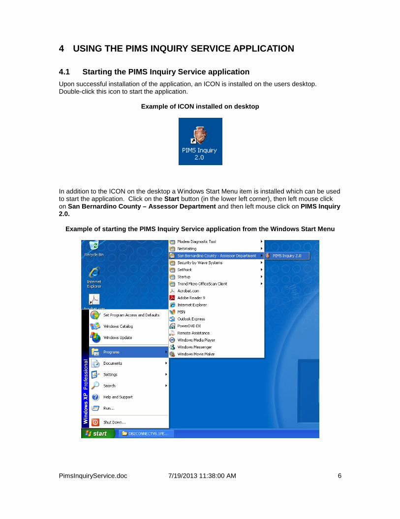
4.1 Starting the PIMS Inquiry Service application Upon successful installation of the application, an ICON is installed on the users desktop. Double-click this icon to start the application.
Example of ICON installed on desktop
In addition to the ICON on the desktop a Windows Start Menu item is installed which can be used to start the application. Click on the Start button (in the lower left corner), then left mouse click on San Bernardino County – Assessor Department and then left mouse click on PIMS Inquiry 2.0.
Example of starting the PIMS Inquiry Service application from the Windows Start Menu
PimsInquiryService.doc 7/19/2013 11:38:00 AM
7
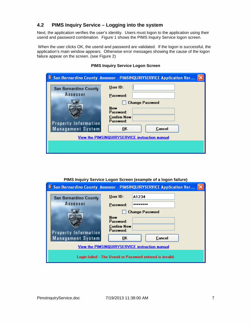
4.2 PIMS Inquiry Service – Logging into the system Next, the application verifies the user’s identity. Users must logon to the application using their userid and password combination. Figure 1 shows the PIMS Inquiry Service logon screen. When the user clicks OK, the userid and password are validated. If the logon is successful, the application’s main window appears. Otherwise error messages showing the cause of the logon failure appear on the screen. (see Figure 2)
PIMS Inquiry Service Logon Screen
PIMS Inquiry Service Logon Screen (example of a logon failure)

PimsInquiryService.doc 7/19/2013 11:38:00 AM
8
4.3 PIMS Inquiry Service – Changing Logon Password • Checking the “Change Password” checkbox will initiate the change logon password
function. By checking “Change Password”, the “New Password” and the “Confirm New Password” input areas will be ready for users input. The rules for a valid password will be automatically displayed on the screen.
• Your logon password will also expire after a period of time, (60 days) when the password
is expired; the change password screen will automatically display and prompt you to change your password.
The user needs to enter the new password and confirm the new password by re-entering the new password in the confirm password box. If the new password change is successful, a message will be displayed stating that the password change was successful and the user will be allowed to proceed into the PIMSINQUIRYSERVICE application. If the new password change is unsuccessful, an error message will be displayed and the user will not be allowed to proceed until the password change has been successful. Please note that the user is never required to change his or her password unless the current password has in fact expired. The user can change the password at his or her discretion also by clicking on the “change password” checkbox. You must know your existing password before you can change it, otherwise the system will not allow you to proceed.

PimsInquiryService.doc 7/19/2013 11:38:00 AM
9
PIMS Inquiry Service change password screen (the user has initiated a change password request by clicking on the change password checkbox)
PIMS Inquiry Service Change password screen (example of a successful change password request)

PimsInquiryService.doc 7/19/2013 11:38:00 AM
10
4.4 Security Authentication A user must not only have a valid userid and password combination, but also must be authorized to use the system by the system administrator.
Your password must comply with the following requirements
If you have not been authorized to use the application by the system administrator, the following error message is displayed and, after clicking OK, the application terminates.
Example of user who does not have security clearance to use the application.

PimsInquiryService.doc 7/19/2013 11:38:00 AM
11
4.5 PIMS Inquiry Service Main Screen The main screen is shown in Figure 3. The top of the screen has the sections: Parcel Inquiry, Name Search, Situs Search, ASSR Map Book Search, Parcel Map Search, Tract Map Search, Attached Search and Property ID Search. To perform an inquiry the user must first perform one of the Search Options or enter a parcel number in the Parcel Inquiry entry screen.
PIMS Inquiry Service Main Screen
• Error messages or informative messages appear in the message area below
.

PimsInquiryService.doc 7/19/2013 11:38:00 AM
12
5 MINIMIZE/MAXIMIZE BUTTON In the PIMS Inquiry Service application there is a minimize/maximize button which is used to allow users to see more of the property information screen. Once a property has been selected information appears in a minimized state. Users can click the Maximize button to enlarge the screen (see screenshots below)
Minimized

PimsInquiryService.doc 7/19/2013 11:38:00 AM
13
Maximized

PimsInquiryService.doc 7/19/2013 11:38:00 AM
14
6 TOOLTIPS In the PIMS Inquiry Service application, all information with blue text is tooltip enabled. Tooltips are informational windows that display on the screen whenever the mouse hovers over a tooltip field. Tooltips are used mainly in this application to provide more descriptive information for a field.
Example of tooltip Note the small yellow window that reads “ASSESSED BY COUNTY”. This is more descriptive information for the Tax status field. In this case, a tax status value of 1 means “ASSESSED BY COUNTY”. As mentioned previously, all blue fields have tooltip capability.
PimsInquiryService.doc 7/19/2013 11:38:00 AM
15
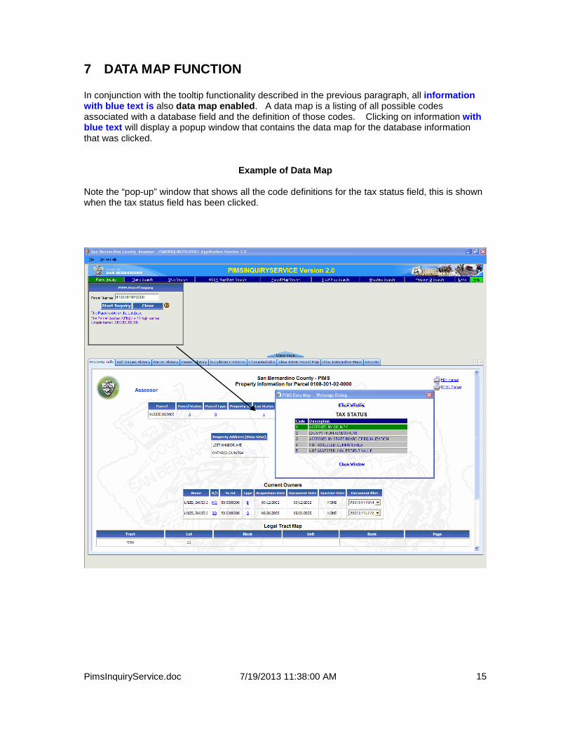
7 DATA MAP FUNCTION In conjunction with the tooltip functionality described in the previous paragraph, all information with blue text is also data map enabled. A data map is a listing of all possible codes associated with a database field and the definition of those codes. Clicking on information with blue text will display a popup window that contains the data map for the database information that was clicked.
Example of Data Map
Note the “pop-up” window that shows all the code definitions for the tax status field, this is shown when the tax status field has been clicked.

PimsInquiryService.doc 7/19/2013 11:38:00 AM
16
8 VIEW PARCEL MAP FUNCTION The Assessor stores parcel maps in PDF format for real property parcels (parcels which use the number ‘0’ in the 10th position and represent permanent, nonmovable property). The PIMS Inquiry Service application allows the integrated viewing of these parcel maps. Note that parcel maps are only available for real property parcels only and some real parcel maps may not yet be available. The PIMS Inquiry Service application detects whether or not a parcel map is available for the parcel being referenced. If a parcel map IS available for the current parcel a PDF image of the parcel map will be displayed in a new window (see screenshot below).
• The user of the application may click on the “VIEW ASSR PARCEL MAP” tab to retrieve and display the parcel map image.
PimsInquiryService.doc 7/19/2013 11:38:00 AM
17
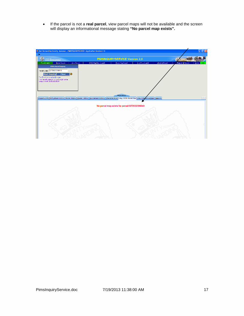
• If the parcel is not a real parcel, view parcel maps will not be available and the screen will display an informational message stating “No parcel map exists”.

PimsInquiryService.doc 7/19/2013 11:38:00 AM
18
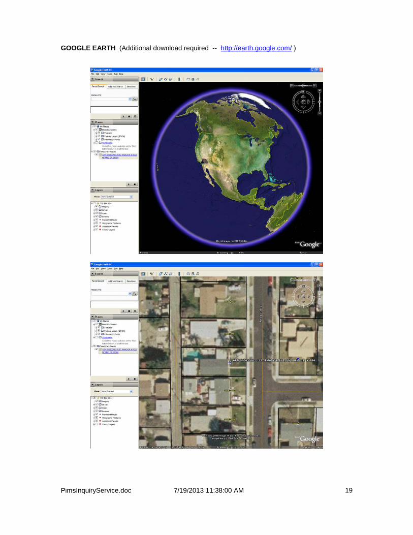
9 VIEW INTERACTIVE MAPS FUNCTION The PIMS Inquiry Service application allows the integrated viewing of parcels within Google Maps and Google Earth. The PIMS Inquiry Service application automatically detects the GIS coordinates of a parcel and maps it the Google Maps or Google Earth interface (see screenshot below).
• The user of the application may click on the “VIEW INTERACTIVE MAPS” tab select which interactive map option they wish to view the parcel in.
See below for a sample of both the Google Maps and Google Earth interfaces: GOOGLE MAPS (No additional download required)
PimsInquiryService.doc 7/19/2013 11:38:00 AM
19
GOOGLE EARTH (Additional download required -- http://earth.google.com/ )

PimsInquiryService.doc 7/19/2013 11:38:00 AM
20
10 SEARCH OPTIONS The Search Options that are available are:
• Parcel Inquiry (by Number) • Name Search • Situs Search • ASSR Map Book Search • Parcel Map Search • Tract Map Search • Attached Parcel Search • Property ID Search
To begin execution of a search, the user can select the search by single clicking with the Search Name with the left mouse button. The middle section of the screen then changes to allow the user to enter information to perform the search.

PimsInquiryService.doc 7/19/2013 11:38:00 AM
21
10.1 Parcel Inquiry When the user selects the Parcel Inquiry search option, an input area titled “Enter 13-digit Parcel Number” is displayed to the right of the menu. The cursor is positioned in the Parcel Number field when the screen is displayed
Parcel Inquiry Search Screen
• To perform a parcel search, the user enters a 13-digit parcel number in the Parcel Number field, and then clicks the Start Inquiry button. If a 13-digit parcel number is not entered, then the user is prompted to enter one.
• To clear the input data, the user can click on the “Clear” button.
• For help with the Parcel Inquiry Search click the “Question Mark”.
• If the parcel number entered is located in the PIMS database, the initial Parcel Information screen is displayed with the information associated with the parcel number. The Parcel Information screen consists of important information related to the parcel including: Parcel Status, Tax Status, Situs Address, Current owners and mailing address, legal description and more.
• The current parcel number that is displayed is shown at the top of the page.
If the parcel number entered is not located on the PIMS database, a message stating: “The parcel number you entered does not exist on the database” is displayed in the informational area.

PimsInquiryService.doc 7/19/2013 11:38:00 AM
22
10.2 Search Limits Search Limits are setup for each of the 6 searches that are available in this application. When a user executes a given search, search results are displayed up to the search limit defined for the search that was executed. In addition, a message is displayed showing the total number of matches found. The user may need to refine the search criteria until the desired results have been obtained.
Current Search Limit Settings Search Type Limit Name Search Up to 500 matches will be displayed. Situs Search Up to 600 matches will be displayed. Parcel Map Search Up to 300 matches will be displayed. Tract Map Search Up to 300 matches will be displayed. Attached Search Up to 300 matches will be displayed. Property ID Search Up to 300 matches will be displayed.
10.3 Name Search When the user selects the Name search option, the Name Search Screen is displayed. The screen includes two radio buttons labeled Active Names and Inactive Names. When the search is performed, parcels are selected only for owners who are active or inactive depending upon whether the Active Names or Inactive Names radio button is selected. The definition of an “active owner” is: An owner who has an ownership interest in the property as of the current date. An inactive owner is an owner who does not have an ownership interest in the property as of the current date. The Active Names radio button is selected when the screen initially displays. The Name Search Screen also contains two check boxes labeled 1) Formatted Name Search and 2) Unformatted Name Search. The Formatted Name check box is selected when the Name Search Screen loads. If the Formatted Name check box is selected, the search input consists of Last Name and First Name. The name search function displays parcels owned by individuals whose names match the search criteria. The parcels are retrieved sorted by the individual names. If the Unformatted Name check box is selected, the search input consists of Unformatted Name. The name search displays parcels owned by businesses or aggregate names 1 that match the name given in the Unformatted Name field. The parcels are retrieved sorted by the business/aggregate names. An asterisk can be entered at the end of the characters in the Last Name, First Name and Unformatted Name fields to find all parcels that match the characters preceding the asterisk. Use of an asterisk is known as a wildcard search. An Aggregate Name is a name, other than a business name, that has been formed either by combining an individual’s name (e.g. – Jones, John Paul) or by combining two individuals’ names (e.g. – John and Mary Jones)

PimsInquiryService.doc 7/19/2013 11:38:00 AM
23
Formatted Name Search Screen
• Search Criteria must be entered for last name when processing a Formatted Name Search, first name criteria is optional.
• To perform the search, the user clicks the “Search” button. Parcels that match the
search criteria are displayed up to the search limit defined for the name search.
• To clear the search criteria input the user can click the “Clear” button.
• For help with the Parcel Inquiry Search click the “Question Mark”.

PimsInquiryService.doc 7/19/2013 11:38:00 AM
24
Unformatted Name Search Screen
• Search Criteria must be entered for unformatted name when processing an Unformatted
Name Search.
• To perform the search, the user clicks the “Search” button. Parcels that match the search criteria are displayed up to the search limit defined for the name search.
• To clear the input data, the user can click the “Clear” button.
• For help with the Parcel Inquiry Search click the “Question Mark”.

PimsInquiryService.doc 7/19/2013 11:38:00 AM
25
10.4 Name Search When the search is performed, the screen displays parcels whose owner names satisfy the search criteria (use the scroll bar to the right to see the entire list). The fields in the table listing the parcel numbers cannot be altered.
Name Search Results Screen
• Informative messages showing how many search matches were found are displayed on the screen. If no matches were found, the screen displays “0 matches found”.
• If the user single-clicks on a row in the search results table, the property information for
the clicked parcel is displayed.

PimsInquiryService.doc 7/19/2013 11:38:00 AM
26
10.5 Situs Search When the user selects the Situs Search option, the Situs Search Screen is displayed. A Situs search is a search of all property addresses in the PIMS database. To perform a Situs Search, the user must enter at minimum the street name search criteria. To further restrict the search, the user can optionally enter criteria in the other fields. Wildcard searches can be performed using the Street Name and Street Number fields by appending an asterisk after the last character of the search input. A search is made for all parcels that match the criteria specified in the Situs Search fields.
Situs Search Screen • Search Criteria must be entered at minimum for Street Name. Wild cards are supported
for both Street Number and Street Name.
• To perform the search, the user clicks the “Search” button. Parcels that match the search criteria are displayed up to the search limit defined for the Situs search.
• To clear the search input data, the user clicks the “Clear” button.
• For help with the Parcel Inquiry Search click the “Question Mark”.
Situs Search Results Screen
• When the search is performed, the screen displays all parcels whose property (situs) addresses satisfy the search criteria. The fields in the table listing the parcel numbers cannot be altered.
• Informative messages showing how many search matches were found are displayed on
the screen. If no matches were found, the screen displays “No matches were found for the Situs Search”.
• If the user single-clicks on a row in the search results table, the property information for
the clicked parcel is displayed.
PimsInquiryService.doc 7/19/2013 11:38:00 AM
27
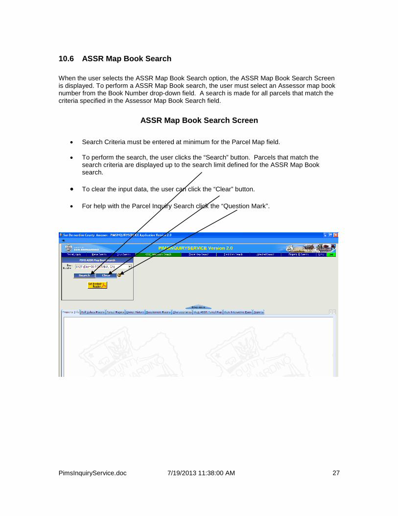
10.6 ASSR Map Book Search When the user selects the ASSR Map Book Search option, the ASSR Map Book Search Screen is displayed. To perform a ASSR Map Book search, the user must select an Assessor map book number from the Book Number drop-down field. A search is made for all parcels that match the criteria specified in the Assessor Map Book Search field.
ASSR Map Book Search Screen
• Search Criteria must be entered at minimum for the Parcel Map field.
• To perform the search, the user clicks the “Search” button. Parcels that match the search criteria are displayed up to the search limit defined for the ASSR Map Book search.
• To clear the input data, the user can click the “Clear” button.
• For help with the Parcel Inquiry Search click the “Question Mark”.

PimsInquiryService.doc 7/19/2013 11:38:00 AM
28
ASSR Map Book Search Results Screen
• When the search is performed, the screen displays a list of all parcels that satisfy the ASSR Map Book search criteria. The fields in the table listing the parcel numbers cannot be altered.
• Informative messages showing how many search matches were found are displayed on
the screen.
• If the user single-clicks on a row in the search results table, the parcel map for the clicked book and page is displayed.

PimsInquiryService.doc 7/19/2013 11:38:00 AM
29
10.7 Parcel Map Search When the user selects the Parcel Map Search option, the Parcel Map Search Screen is displayed. To perform a Parcel Map search, the user must enter at a minimum a parcel map number in the Parcel Map Nbr field. To further restrict the search, the user may optionally enter criteria in the Parcel/Lot field. A search is made for all parcels that match the criteria specified in the Parcel Map Search fields.
Parcel Map Search Screen
• Search Criteria must be entered at minimum for the Parcel Map field.
• To perform the search, the user clicks the “Search” button. Parcels that match the search criteria are displayed up to the search limit defined for the Parcel Map search.
• To clear the input data, the user can click the “Clear” button.
• For help with the Parcel Inquiry Search click the “Question Mark”.
Parcel Map Search Results Screen
• When the search is performed, the screen displays a list of all parcels that satisfy the Parcel Map search criteria. The fields in the table listing the parcel numbers cannot be altered.
• Informative messages showing how many search matches were found are displayed on
the screen. If no matches were found, the message “0 matches found” is displayed.
• If the user single-clicks on a row in the search results table, the property information for the clicked parcel is displayed.

PimsInquiryService.doc 7/19/2013 11:38:00 AM
30
10.8 Tract Map Search When the user selects the Tract Map Search option, the Tract Map Search Screen is displayed. To perform a Tract Map search, the user must enter a Tract Map number in the Tract Map field. To further restrict the search, the user may optionally enter criteria in the other fields. The other fields include Lot and Block. A search is made for all Tracts that match the criteria specified in the Tract Map Search fields.
Tract Map Search Screen
• Search Criteria must be entered at minimum for the Tract field.
• To perform the search, the user clicks the “Search” button. Parcels that match the search criteria are displayed up to the search limit defined for the Tract Map search.
• To clear the input data, the user can click the “Clear” button.
• For help with the Parcel Inquiry Search click the “Question Mark”.
Tract Map Search Results Screen
• When the search is performed, the screen displays all parcels that satisfy the Tract Map
search criteria (Use the scroll bar to the right of the list to see all parcels). The fields in the table listing the parcel numbers cannot be altered.
• Informative messages showing how many search matches were found are displayed on
the screen. If no matches were found, the message “0 matches found” is displayed.
• If the user single-clicks on a row in the search results table, the property information for the clicked parcel will be displayed.

PimsInquiryService.doc 7/19/2013 11:38:00 AM
31
10.9 Attached Parcel Search When the user selects the Attached Parcel Search option, the Attached Parcel Search Screen is displayed. To perform an Attached Parcel search, the user must enter the first 9 digits of a parcel number in the Attached Parcel Number field.
Attached Parcel Search Screen
• Attached Parcel criteria must be entered.
• To perform the search, the user clicks the “Search” button. Parcels that match the search criteria are displayed up to the search limit defined for the Attached Parcel search.
• To clear the input data, the user can click the “Clear” button.
• For help with the Parcel Inquiry Search click the “Question Mark”.
Attached Parcel Search Results Screen
• When the search is performed, the screen displays all parcels that satisfy the Attached parcel search criteria. The fields in the table listing the parcel numbers cannot be altered.
• Informative messages showing how many search matches were found are displayed on
the screen. If no matches were found, the screen will display “0 matches found”.
• If the user single-clicks on a row in the search results table, the property information for the clicked parcel is displayed.

PimsInquiryService.doc 7/19/2013 11:38:00 AM
32
10.10 Property ID Search When the user selects the Property ID Search option, the Property ID Search Screen is displayed. To perform a Property ID search, the user must enter a Property ID (up to 15 characters) to search on.
Property ID Search Screen
• Property ID search criteria must be entered.
• To perform the search, the user clicks the “Search” button. Parcels that match the search criteria are displayed up to the search limit defined for the Property ID search.
• To clear the input data, the user can click the “Clear” button.
• For help with the Parcel Inquiry Search click the “Question Mark”.
Property ID Search Results Screen
• When the search is performed, the screen displays all parcels that satisfy the PropertyID search criteria. The fields in the table listing the parcel numbers cannot be altered.
• Informative messages showing how many search matches were found are displayed on
the screen. If no matches were found, the screen will display “0 matches found”.
• If the user single-clicks on a row in the search results table, the property information for the clicked parcel is displayed.

PimsInquiryService.doc 7/19/2013 11:38:00 AM
33
11 PROPERTY DETAIL INFORMATION Property Detail information includes:
• Property Information • Ownership Information • Parcel History • Roll Values History • Supplement History • Land Characteristics • SFR Characteristics • Other Characteristics
Before the Property Detail Information option can be executed, the user must either enter a 13-digit parcel number and execute a Parcel Inquiry or the user can search (using any of the defined search processes) and then click on a resulting search match. Once that has been done, the user can click on the tabbed control on the screen corresponding to the information that the user desires to view.
11.1 Parcel Information • The Parcel Information screen is always shown by default whenever a Parcel Inquiry is
executed or whenever a search result is clicked.
• An example of the information that is displayed on the Property Information screen is shown below. The data shown on the screen cannot be altered.
Property Information Screen

PimsInquiryService.doc 7/19/2013 11:38:00 AM
34
11.2 Ownership Information Ownership Information consists of:
• Current ownership information (Owners who currently have an ownership interest in the property)
• Ownership History (All owners who have ever had an ownership interest in the property). An example of the information that is displayed on the Ownership Information screen is shown below. The data shown on the screen cannot be altered.
• Current ownership is shown at the top of the screen.
• Ownership History is shown below the current ownership information.
• Note that all document numbers associated with the ownership is displayed in a drop-down box.

PimsInquiryService.doc 7/19/2013 11:38:00 AM
35
11.3 Parcel History The Parcel History screen shows all the events that have occurred on the given parcel. Examples of such events would be new construction or transfer of ownership.
• Note that all parcel numbers associated with the event are displayed in a drop-down box. This is handy in researching all subdivided parcels for a given event for example.

PimsInquiryService.doc 7/19/2013 11:38:00 AM
36
11.4 Roll Values History The Roll Values History screen shows information pertaining to the Assessor’s Roll. Information from the latest roll year and 8 previous roll years is displayed if the information is available. A good example of the use of Roll Value information is that it signifies the value of the property for purposes of property taxation.
Roll Values History Screen
• In order to preserve screen space, the owner names may be truncated (see below). You can use the “tooltips” feature by moving your mouse over the text of the owner names and the full owner name text will be displayed.

PimsInquiryService.doc 7/19/2013 11:38:00 AM
37
11.5 Supplement History The Supplement History screen shows supplemental roll information associated with a parcel.
Supplement History Screen
• You can use the scroll bars to scroll vertically if the amount of data fills more than one screen.
• In order to preserve screen space, the owner names may be truncated (see below). You
can use the “tool tips” feature by moving your mouse over the text of the owner names and the full owner name text will be displayed.

PimsInquiryService.doc 7/19/2013 11:38:00 AM
38
11.6 Characteristics The Characteristics screen displays information about the property such as lot size, type of electricity used at the property etc.
Characteristics Screen

PimsInquiryService.doc 7/19/2013 11:38:00 AM
39
11.7 SFR Characteristics SFR (Single Family Residence) characteristics show information about the structure(s) that are built on the property. Examples of SFR information include type of roof on the structure, number of bedrooms/bathrooms etc. There can be multiple SFR characteristics associated with a given parcel. If multiple SFR characteristics exist the screen will appear allowing the user to scroll down to view all of the associated SFR characteristics. See screenshots below for an example of how multiple and single SFR characteristics are displayed.
SFR Characteristics Example (Single)

PimsInquiryService.doc 7/19/2013 11:38:00 AM
40
SFR Characteristics Screen (where multiple SFR characteristics exist)
• SFR characteristics for each SFR will be grouped by sequence number. • Note the “scroll bar” on the right side of the screen, this allows the user to scroll to
additional SFR characteristics.

PimsInquiryService.doc 7/19/2013 11:38:00 AM
41
11.8 Other Characteristics The Other characteristic screen shows information about structures other than SFR (Single Family Residence). Like SFR characteristics, multiple OTHER characteristics may exist on a given parcel. . When multiple OTHER characteristics exist, they will be grouped on the screen by sequence number. See screenshots below for an example of how multiple and single OTHER characteristics are displayed.
Other Characteristics Screen (where only one exists) • Note the vertical scroll bar. There is quite a bit of information associated with other
characteristics, therefore the user can scroll down to see more OTHER characteristic information.

PimsInquiryService.doc 7/19/2013 11:38:00 AM
42
Other Characteristics Screen (where multiple OTHER characteristics exist)
• OTHER characteristics for each structure will be grouped by sequence number. • Note the “scroll bar” on the right side of the screen, this allows the user to scroll to
additional OTHER characteristics.

PimsInquiryService.doc 7/19/2013 11:38:00 AM
43
11.9 Reports This application provides the ability to generate reports from information you have retrieved from our database. You may print out parcel detail information by clicking on the “Reports” tab. Each property detail item has a print button that will generate a simple report. See the screenshots below for a demonstration of how this works. The example below will show how to print ownership information to your printer. Remember, the print function is available for each and every property detail item.
• Click on the “Ownership History Report” link.

PimsInquiryService.doc 7/19/2013 11:38:00 AM
44
• You will receive a formatted .pdf (Adobe Reader) report that can be sent to the printer if you desire, you can click on the printer icon to send the report to your printer.
12 CONCLUSION
• The PIMS Inquiry Service application is designed to provide useful Assessor information to outside subscribers.
• The application was designed so that we can provide good response times to the user.
Even those who are still using dial-up connections should have a fairly good response experience.