sand backpassing feasibility assessment
TRANSCRIPT

G:\ADMIN\B17842.G.DCP_TRESB_BACKPASSING\R.B17842.002.01.DOC
Tweed River Entrance Sand Bypassing Sand Backpassing Feasibility Assessment
A part of BMT in Energy and Environment
R.B17842.002.01.doc September 2010

G:\ADMIN\B17842.G.DCP_TRESB_BACKPASSING\R.B17842.002.01.DOC
Tweed River Entrance Sand Bypassing
Sand Backpassing Feasibility Assessment
Prepared For: NSW LPMA
Prepared By: BMT WBM Pty Ltd (Member of the BMT group of companies)
Offices
Brisbane Denver Mackay
Melbourne Newcastle
Perth Sydney
Vancouver


CONTENTS I
G:\ADMIN\B17842.G.DCP_TRESB_BACKPASSING\R.B17842.002.01.DOC
CONTENTS
Contents i List of Figures iii List of Tables iii Executive Summary iv
1 INTRODUCTION 1-1
1.1 Background 1-1 1.2 Objectives and Scope 1-1
2 BEACH CONDITIONS AND SURF QUALITY 2-1
2.1 Shoreline Response to Bypassing 2-1 2.2 Surf Quality 2-4
2.2.1 Historical Conditions 2-4 2.2.2 Impact of Back-passing 2-8
3 BACK-PASSING DESIGN AND COST-EFFECTIVENESS 3-1
3.1 Design of Back-Passing Operation 3-1 3.1.1 Conceptual Design 3-1 3.1.2 Pipeline Discharge 3-2 3.1.3 Back-passing from Entrance Dredging 3-3 3.1.4 Back-passing Rate 3-3 3.1.5 Back-passing Location 3-4
3.2 Benefits and Adverse Impacts 3-6 3.3 Risks 3-6 3.4 Monitoring and Management Considerations 3-7 3.5 Cost Assessment 3-8
3.5.1 Back-passing Cost 3-8 3.5.2 Incremental Cost of Back-passing 3-9
4 LEGISLATIVE CONSIDERATIONS 4-1
4.1 Regulatory and Policy Framework 4-1 4.2 Consistency with Project Legislation and Objectives 4-1

CONTENTS II
G:\ADMIN\B17842.G.DCP_TRESB_BACKPASSING\R.B17842.002.01.DOC
4.2.1 Purpose and Objectives 4-1 4.2.2 Applicable Definitions within the Act 4-2 4.2.3 Sand Volumes 4-3
4.3 Planning Approvals 4-4 4.3.1 TRESB Act 1995 4-5 4.3.2 Environmental Planning and Assessment Act 1979 4-5 4.3.3 Fisheries Management Act 1994 4-10 4.3.4 Protection of the Environment Operations Act 1997 4-10 4.3.5 Coastal Protection Act 1979 4-11 4.3.6 Water Management Act 2000 4-13 4.3.7 Approval from NSW Maritime 4-13 4.3.8 Heritage Approvals 4-13 4.3.9 Commonwealth Environment Protection and Biodiversity
Conservation Act 1999 4-14
5 ENVIRONMENTAL AND SOCIAL ISSUES 5-1
5.1 Environmental Considerations 5-1 5.1.1 Terrestrial Flora 5-1 5.1.2 Marine Flora 5-2
5.2 Fauna 5-2 5.3 Bedrock Reefs 5-4 5.4 Artificial Reefs 5-4 5.5 Environmental Planning Provisions 5-4
5.5.1 Tweed Shire Local Environmental Plan 5-4 5.5.2 State Environmental Planning Policies (SEPP) 5-5
5.6 Social Considerations 5-5 5.6.1 Tenure 5-5 5.6.2 Cultural Heritage 5-5 5.6.3 Fisheries 5-5 5.6.4 Surfing 5-6
6 LIAISON & CONSULTATION 6-1
6.1 Overview 6-1 6.2 Tweed Shire Council 6-1 6.3 Gold Coast City Council 6-2 6.4 TRESBCo 6-3
7 FEASIBILITY ASSESSMENT 7-1

LIST OF FIGURES III
G:\ADMIN\B17842.G.DCP_TRESB_BACKPASSING\R.B17842.002.01.DOC
8 REFERENCES 8-1
APPENDIX A: BACK-PASSING SCENARIOS FOR COSTING PURPOSES A-1
LIST OF FIGURES
Figure 2-1 Satellite Image of Letitia and Southern Gold Coast Beaches 2008 (Google) 2-1
Figure 2-2 Monthly Time Series of Surveyed Quantity Changes in NSW (top) and Qld (bottom) 2-2
Figure 2-3 Measured Recession of Letitia Spit 2-3 Figure 2-4 Shoreline Widening at Gold Coast Beaches 2-3 Figure 2-5 Point Danger to Bilinga 1956 2-6 Figure 2-6 Point Danger Area 1961 2-6 Figure 2-7 Satellite Image April 2003 (Google) 2-7 Figure 2-8 Satellite Image June 2008 (Google) 2-7 Figure 2-9 Satellite Image April 2009 (Google) 2-7 Figure 3-1 Conceptual Back-Passing Design Options 3-1 Figure 3-2 Conceptual Back-Passing by Pipeline 3-2 Figure 3-3 Shoreline Change for Various Discharge Locations: Back-passing
Scenario 2: 3-5 Figure 4-1 Management Actions from the Tweed Shire Coastline Management
Plan 2005 (Umwelt 2005) 4-12
Figure A- 1 Base Case Scenario: No Back-passing A-2 Figure A- 2 Hypothetical Back-passing Scenario 1 A-3 Figure A- 3 Hypothetical Back-passing Scenario 2 A-4
LIST OF TABLES
Table 3-1 Summary of Base Case and Back-passing Scenarios Over 15 years 3-9 Table 3-2 Incremental Cost of Back-passing Versus Base Case 3-10 Table 4-1 Summary of Relevent Planning Approvals 4-4 Table 5-1 Threatened Species Recorded on Letitia Spit or Adjacent Estuary
(NPWS 2010) 5-3 Table 7-1 Summary of Advantages and Disadvantages of Back-passing 7-4

EXECUTIVE SUMMARY IV
G:\ADMIN\B17842.G.DCP_TRESB_BACKPASSING\R.B17842.002.01.DOC
EXECUTIVE SUMMARY This report sets out the findings of the assessment by BMT WBM of various factors relating to the feasibility of back-passing as part of the TRESB project. It is feasible and practical to undertake back-passing of sand to Letitia Beach either by nearshore placement of sand dredged from the river entrance or by pumping via a pipeline from the existing bypassing plant to a discharge outlet location along the beach. Back-passing offers advantages in improved control of sand quantity and in the temporal pattern of delivery to better match the natural sand supply to Queensland to the natural supply past Fingal. The option to back-pass via pumping from the jetty system through a land-based pipeline would place the sand directly into the surfzone at the waterline. It is considered highly probable that, provided the back-passing rate is sufficient, this would widen the beach berm and would effectively lead over time to accretion of the shoreline both updrift and downdrift of the discharge location. The option to place the sand via a bottom-dump dredger represents an effective back-passing option also and potentially offers additional benefits over pipeline back-passing. No onshore infrastructure would be required and greater flexibility would be available in the location of the sand placement along Letitia Spit. However building of the upper beach and dune would take a significant time and, as a standalone process, would not provide immediate benefits in terms of shoreline maintenance. Back-passing via the pipeline option may be preferred as the primary mechanism from the perspectives of both effectiveness and cost. A combination of the two processes could be undertaken, giving flexibility in where the back-passed sand may be sourced and placed – ie from the jetty system to a fixed discharge point or from the entrance dredging to the preferred placement location at any time. Legislative considerations are set out in Chapter 4. Under both the current Tweed Shire LEP 2000 and the draft shire wide LEP 2010, a Part V application would be required for the pipeline option. The extent of environmental impact assessment for approval would be subject to the findings of a Review of Environmental Factors (REF). Preliminary indications are that adverse impacts would be minor and able to be mitigated. Further investigation is needed to ensure that the legislation allows the sand to be placed along Letitia Beach rather than to Queensland, by either pipeline or dredging. Predictive modelling methods for determining a suitable back-passing design have significant limitations and uncertainties. Back-passing should be regarded initially on a trial basis, with careful monitoring and flexibility to modify the strategy to achieve optimum outcomes. Comprehensive monitoring of any back-passing together with flexible reactive response in terms of the back-passing location, rate and method are essential. The optimum discharge location for back-passing needs further consideration based on effectiveness and the constraints imposed by access across the dunes to the beach at particular locations. A location around 1300m south of the jetty would restore and maintain the shoreline position effectively, but is at the limit of feasible pumping. Locations closer to the jetty are less effective in restoring the shoreline further south but may assist in widening the beach at the jetty over time. The primary risk is that the back-passing would not be effective. Given that this conclusion will likely be reached over a long period, adequate time will be available for deciding the response and direction to follow the back-passing trial. Another significant risk is that premature judgements may be made about the success or failure of a particular back-passing strategy in the absence of a full understanding of the context of the performance in the longer term. This applies also to community perceptions and responses to the back-passing and these would need to be managed. Cost implications of back-passing have been considered in the context of a likely alternative ‘base case’ operation without back-passing over the next 15 years. Two scenarios have been assessed, each with different net benefit to the Letitia Spit shoreline. All scenarios assume that the sand transport rate to the jetty can be scaled back to equal the supply rate at Fingal with beach widening there.

EXECUTIVE SUMMARY V
G:\ADMIN\B17842.G.DCP_TRESB_BACKPASSING\R.B17842.002.01.DOC
A summary of the estimated costs of the incremental differences in pumping, dredging and monitoring between the adopted scenarios over 15 years is provided in Table 3-2. This shows that the incremental cost of back-passing would be approximately $2.5 - 3.0 million over 15 years, with net benefit to Letitia Spit of about 0.7 – 1.0 million m3 compared with the base case net loss of about 0.6 million m3. Other benefits include reduced sand delivery to Queensland of about 7.2 – 7.6 million m3 compared to the base case delivery of 8.2 million m3 over the 15 years, such that establishment of more suitable equilibrium conditions for beach width and surf quality may be achieved more readily. Given that approximately 7.5 million m3 would be bypassed over the 15 year period by both pumping and dredging at an operational cost of about $35 – 40 million, the incremental cost of the back-passing is relatively minor (~7.5%) compared to the potentially significant benefits. A summary of advantages and disadvantages is presented in the Table below.
Advantages Disadvantages 1. Provides a means of catering for the natural variability of sand supply in controlling the quantities of sand bypassed via the jetty.
1. Adoption of the pipeline option would involve an additional incremental cost of $1.0-1.5 million associated mainly with the pipeline infrastructure to the discharge location.
2. Provides a mechanism to restore and maintain Letitia Beach shoreline in the longer term.
2. Will involve additional operational cost to return sand to Letitia Beach.
3. Prevents further loss of sand from Letitia Spit.
3. Additional electricity usage and increased CO2 emissions.
4. Provides an operational method for better controlling sand volume delivery to Queensland in the longer term and correcting the past over-supply in the shorter term.
4. For the pipeline option, discharge point safety and interference with access along the beach.
5. May assist in restoring the beach width at the jetty.
5. Additional approvals involving an initial Review of Environmental Factors (REF) to identify the extent of impact assessments needed.
6. Disturbance to the dune system ecology along the pipeline route and/or the beach/marine environment.

INTRODUCTION 1-1
G:\ADMIN\B17842.G.DCP_TRESB_BACKPASSING\R.B17842.002.01.DOC
1 INTRODUCTION
1.1 Background
BMT WBM Pty Ltd has been commissioned to undertake an assessment of the feasibility of back-passing as part of the TRESBS operations to examine the potential for back-passing to provide and improved operations capability. Back-passing potentially offers advantages including more flexible management to cater for the natural variability of sand supply along Letitia Spit, control of sand delivery to Queensland and ability to maintain Letitia Beach as required.
The intention of this assessment is to provide the Governments with advice on a range of issues and considerations relating to back-passing, including current and likely future beach conditions, feasibility and effectiveness, social and environmental implications, consistency with legislation, and longer term implications for flexibility of the operations.
1.2 Objectives and Scope
The study assesses back-passing feasibility in consideration of:
• Viability, effectiveness and cost/benefit;
• Social and environmental implications;
• Consistency with the relevant legislation and the objectives of the TRESB project;
• Specific reference to effectiveness with respect to the Letitia Beach shoreline alignment and dealing with issues of sand build-up at Kirra and Central Kirra;
• Longer term implications for flexibility, and operations.
Specific scope items are:
• Consultation with project partners (LPMA, DERM, GCCC and TSC) to determine their views and needs;
• Consultation with TRESBCo to determine their opinions with regard to operational aspects;
• Assess the current beach conditions and develop a prediction of outcomes over the next 10 years with the current mode of operation;
• Develop conceptual designs and evaluate the effects and benefits of back-passing;
• Address implications for Kirra and its surf quality;
• Identify planning approval requirements and timing of approvals and implementation;
• Estimate costs and benefits;
• Identify and discuss potential adverse impacts, uncertainties and risks.
Matters to be considered and incorporated into the review assessment include the natural variability of the sand transport, including ‘slug’ behaviour of the transport, and the response time involved between operational changes and the effects on the beach system.

BEACH CONDITIONS AND SURF QUALITY 2-1
G:\ADMIN\B17842.G.DCP_TRESB_BACKPASSING\R.B17842.002.01.DOC
2 BEACH CONDITIONS AND SURF QUALITY
2.1 Shoreline Response to Bypassing
The long term net rate of sand supply into Letitia Spit at Fingal since sand bypassing began operation in 2001 has been determined at approximately 557,000 m3/yr. The total quantity of sand bypassed by pumping at the jetty and dredging at the entrance has averaged about 800,000 m3/yr. In addition, there was ‘natural bypassing’ to Queensland of about 40,500 m3/yr. The net result has been a substantial loss of sand from Letitia Spit. As well, because the net sand transport out to the north at Currumbin was about 540,000 m3/yr, there has been a corresponding sand supply to the southern Queensland beaches in excess of that moving away to the north.
The beach conditions in 2009 are illustrated in Figure 2-1.
Figure 2-1 Satellite Image of Letitia and Southern Gold Coast Beaches 2008 (Google)
Figure 2-2 illustrates the surveyed quantities of beach change since 1993 for both the New South Wales system south from the border to Fingal and the Queensland system north to Currumbin. This indicates an overall loss of sand from Letitia Spit of nearly 4 million m3 and a net gain to Queensland of about 4.5 million m3. BMT WBM (2009) discuss the probability that the difference in these quantities may be associated with additional losses south of Fingal not identified in the surveys undertaken.

BEACH CONDITIONS AND SURF QUALITY 2-2
G:\ADMIN\B17842.G.DCP_TRESB_BACKPASSING\R.B17842.002.01.DOC
NSW Monthly Quantity Change since January 1993
-4000000
-3000000
-2000000
-1000000
0
1000000
Jan-
93
Jul-9
3
Jan-
94
Jul-9
4
Jan-
95
Jul-9
5
Jan-
96
Jul-9
6
Jan-
97
Jul-9
7
Jan-
98
Jul-9
8
Jan-
99
Jul-9
9
Jan-
00
Jul-0
0
Jan-
01
Jul-0
1
Jan-
02
Jul-0
2
Jan-
03
Jul-0
3
Jan-
04
Jul-0
4
Jan-
05
Jul-0
5
Jan-
06
Jul-0
6
Jan-
07
Jul-0
7
Jan-
08
Jul-0
8
Jan-
09
Jul-0
9
Qua
ntity
(cub
ic m
etre
s)
Letitia Sth Letitia Cent Letitia Nth Entrance Duranbah River
QLD Monthly Quantity Change since January 1993
-1000000
0
1000000
2000000
3000000
4000000
5000000
6000000
Jan-
93
May
-93
Sep
-93
Jan-
94
May
-94
Sep
-94
Jan-
95
May
-95
Sep
-95
Jan-
96
May
-96
Sep
-96
Jan-
97
May
-97
Sep
-97
Jan-
98
May
-98
Sep
-98
Jan-
99
May
-99
Sep
-99
Jan-
00
May
-00
Sep
-00
Jan-
01
May
-01
Sep
-01
Jan-
02
May
-02
Sep
-02
Jan-
03
May
-03
Sep
-03
Jan-
04
May
-04
Sep
-04
Jan-
05
May
-05
Sep
-05
Jan-
06
May
-06
Sep
-06
Jan-
07
May
-07
Sep
-07
Jan-
08
May
-08
Sep
-08
Jan-
09
May
-09
Sep
-09
Qua
ntity
(cub
ic m
etre
s)
Snapper East Rainbow/Coolangatta Kirra Bilinga Currumbin
Figure 2-2 Monthly Time Series of Surveyed Quantity Changes in NSW (top) and Qld (bottom)

BEACH CONDITIONS AND SURF QUALITY 2-3
G:\ADMIN\B17842.G.DCP_TRESB_BACKPASSING\R.B17842.002.01.DOC
Thus, the erosion at Letitia Spit has resulted from an overall net deficit of sand, with more lost at the northern end to Queensland due to bypassing and natural sand transport than has come into the system past Fingal. The erosion has the form of a substantial drawback of about 120m at the bypassing jetty and progressively reducing shoreline recession further south towards Fingal, as illustrated in Figure 2-3. This may be affected to some extent by short term fluctuations.
Shoreline Change along Letitia Spit since 2000
-150
-100
-50
0
50
0 500 1000 1500 2000 2500 3000 3500Distance from Southern Wall (m)
Shor
elin
e C
hang
e (m
)
Original Shoreline 2007 2008
Fing
al
Trai
ning
Wal
l
Figure 2-3 Measured Recession of Letitia Spit
Analysis of changes to beach width along the southern Gold Coast since 2001 has been undertaken from satellite and aerial photograph imagery for this study, as presented in Figure 2-4. This information is indicative only, but illustrates broadly the extent of the shoreline width changes that have occurred.
Shoreline Change along Gold Coast Beaches since 2001
-50
0
50
100
150
200
250
050010001500200025003000
Distance north of Pt Danger (m)
Shor
elin
e C
hang
e (m
)
Original Shoreline Apr-03 Jun-08 Apr-09
Kirr
a Po
int G
royn
e
Gre
enm
ount
Hill
Figure 2-4 Shoreline Widening at Gold Coast Beaches
BEACH CONDITIONS AND SURF QUALITY 2-4
G:\ADMIN\B17842.G.DCP_TRESB_BACKPASSING\R.B17842.002.01.DOC
The aerial photographs show an initial trend of accretion between Rainbow Bay and North Kirra in which the shoreline and, notably, the nearshore contours out to around 5m depth became progressively more linear along the general coastline alignment rather than following the re-curving shape of each embayment, as shown also in Castelle et al (2006). In so doing, the beaches have become wide in the previously embayed beach areas and the alignment of the nearshore sand bars and depth contours has altered markedly.
The photography also shows that the seaward movement of the beaches and nearshore depths has covered some previously exposed bedrock reefs off Kirra. The initially wide beaches at Rainbow Bay and Greenmount have settled back to a more normal state. The beach at Kirra took some years to accrete and is now retreating as the excess sand volumes continue to disperse towards the north. This trend of sand dispersal can be expected to continue provided sand volumes delivered by the system and as natural bypassing do not exceed the capacity of the waves to move the sand northward from Kirra. Eventually, that capacity and the volumes of sand moved past Fingal onto Letitia Beach need to be in balance for a sustainable future situation.
2.2 Surf Quality
2.2.1 Historical Conditions
The judgement of surf quality is somewhat subjective and depends on the nature of the surfing and the skill of the surfer. However, in this area, surf quality is most sensibly assessed in terms of the conditions offered to those highly skilled board riders for whom the various ‘breaks’ have traditionally had world-wide recognition.
Clearly, there are effects of variable incident wave type and direction and of onshore winds that create ‘choppy’ conditions from time to time. However, the surfers know which circumstances would normally produce good surf at each location and, anecdotally, the most criticised surf location in recent times is Kirra.
As discussed in detail in the IAS/EIS (Hyder et al 1977), attempts to quantify surf quality have focused mainly on the angle of the breaking wave to the seabed contours (the ‘peel angle’) which determines the speed of the ride, as well as the shape of the wave (plunging ‘tubes’ or ‘full’ spilling breaker types).
The IAS/EIS predicted that surf conditions along the southern Queensland beaches would be restored to their original natural state with bypassing that restored the natural flow of sand along the beaches. Also noted in the IAS/EIS were the so-called ‘A-frame’ wave forms at Duranbah which had evolved after construction of the training walls and were predicted to be largely lost as a result of bypassing.
It is of significance that ‘natural’ conditions along this area have not existed since 1961-62 when the training walls were constructed, although it took several years for the effects of the walls to propagate along the system to Kirra. Furthermore, the sand movement through this area is naturally highly ‘slug’ like, with considerable variability of the sand bars and associated surf break conditions.
As such, recollections of surfing conditions after around 1962 to 1965 are subject to circumstances influenced by both natural variability and the impacts of coastal works including:
BEACH CONDITIONS AND SURF QUALITY 2-5
G:\ADMIN\B17842.G.DCP_TRESB_BACKPASSING\R.B17842.002.01.DOC
• Natural variability of the sand supply and nearshore sand bar bathymetry affecting surf conditions;
• Extensive erosion from Duranbah north caused by the training walls;
• Accretion at Coolangatta, exacerbated erosion at Kirra and changes to the nearshore contours caused by the Kirra Point groyne;
• Effects of the Miles Street groyne;
• Effects of interim beach nourishment; and
• Effects of the bypassing since 2001.
The attempt to use the bypassing to restore the pre-1962 conditions have not been entirely successful to date. As comprehensively documented (BMT WBM 2009), an excessive amount of sand has been delivered to Queensland and this has not translated consistently to ‘ideal’ surf quality. That is, more sand does not mean better surf. Rather, it is apparent that the configuration of the headlands is such that good surf conditions relate to sufficient but not too much sand transport past them and that the ideal rate has been exceeded.
The aerial photos in Figure 2-5 and Figure 2-6 illustrate the natural conditions prior to training wall construction. The beaches at that time were not exceptionally wide and the nearshore bathymetry and sand bars were quite variable.
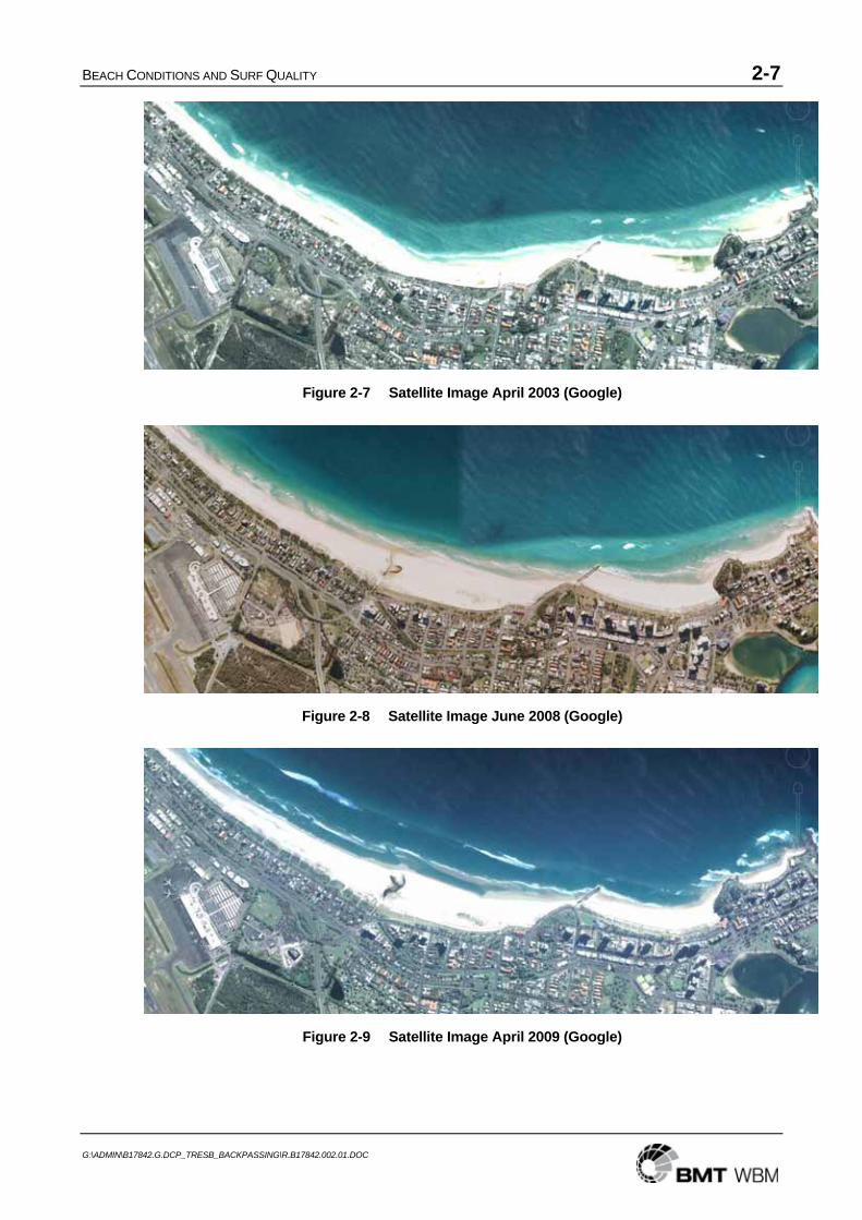
The satellite imagery in Figures 2-7 to 2-9 shows that the beach and nearshore bathymetry have been altered substantially along this section of coastline since bypassing began. Beach widths are now considerably wider than before. However, the beach width itself is not a good indicator of the nearshore contour alignment, which determines the ‘peel angle’ for surfing. This is evident in Figure 2-8 (June 2008) and Figure 2-9 (April 2009) in which beach widths are similar but the nearshore contours are quite different, the latter showing considerably less sand along Rainbow Bay and Greenmount, most probably in response to the reduced bypassing over that time. However, that reduction in nearshore sand had not propagated to Kirra which continues to exhibit a large sand volume and acute peel angles.

BEACH CONDITIONS AND SURF QUALITY 2-6
G:\ADMIN\B17842.G.DCP_TRESB_BACKPASSING\R.B17842.002.01.DOC
Figure 2-5 Point Danger to Bilinga 1956
Figure 2-6 Point Danger Area 1961
BEACH CONDITIONS AND SURF QUALITY 2-7
G:\ADMIN\B17842.G.DCP_TRESB_BACKPASSING\R.B17842.002.01.DOC
Figure 2-7 Satellite Image April 2003 (Google)
Figure 2-8 Satellite Image June 2008 (Google)
Figure 2-9 Satellite Image April 2009 (Google)

BEACH CONDITIONS AND SURF QUALITY 2-8
G:\ADMIN\B17842.G.DCP_TRESB_BACKPASSING\R.B17842.002.01.DOC
2.2.2 Impact of Back-passing
It is apparent that management of the bypassing would need to focus on reducing the sand quantity at Kirra, both on the beach and nearshore, if the former surf quality is to be restored. However, the conditions at Rainbow Beach through to Greenmount appear to be reasonably close to those evident prior to 1962. On the basis that this is an indication that about the ‘right’ transport is now occurring past Greenmount and that the Kirra condition relates to a transport rate that is too great, it would be expected that Kirra should continue to lose sand progressively over time to become in equilibrium with the sand supply. That may take some years, depending on the incidence of cyclone events.
The key to this strategy is ensuring that the total rate of sand reaching Queensland by bypassing and natural transport to Queensland is kept at the optimum level of about 500,000 m3/yr. However, at present, substantially more than that rate is arriving at the jetty. Back-passing would provide an opportunity to manage the quantities back-passed and bypassed to try to restore more suitable conditions.

BACK-PASSING DESIGN AND COST-EFFECTIVENESS 3-1
G:\ADMIN\B17842.G.DCP_TRESB_BACKPASSING\R.B17842.002.01.DOC
3 BACK-PASSING DESIGN AND COST-EFFECTIVENESS
3.1 Design of Back-Passing Operation
3.1.1 Conceptual Design
The physical mechanisms involved in back-passing involve extraction of sand from the bypassing operation and its delivery back into the longshore sand transport system along Letitia Beach south of the jetty. This could be undertaken by either pumping directly from the jetty system into the littoral zone of longshore transport or redirecting some of the sand extracted from the entrance dredging back to a nearshore deposition area outside the surfzone from which it would migrate shoreward into the longshore transport zone, as illustrated in Figure 3-1.
In terms of its effects on the Letitia Beach shoreline and its behaviour to the north and south of the back-passing location, it could be considered as a beach nourishment exercise rather than building a ‘sand groyne’ in that it represents an input of sand to the local sand budget at and near the discharge point. The beach both updrift and downdrift of the discharge location will widen, whereas a groyne would widen the beach updrift but cause equivalent erosion downdrift.
0 500 1000
Back-pass pumping option
Back-pass dredging option
0 500 10000 500 10000 500 1000
Back-pass pumping option
Back-pass dredging option
Figure 3-1 Conceptual Back-Passing Design Options

BACK-PASSING DESIGN AND COST-EFFECTIVENESS 3-2
G:\ADMIN\B17842.G.DCP_TRESB_BACKPASSING\R.B17842.002.01.DOC
Clearly, a combination of the two processes could be undertaken, giving flexibility in where the back-passed sand may be sourced and placed – ie from the jetty system directly to a fixed location along the beach or from the entrance dredging to designated nearshore areas along Letitia Spit.
3.1.2 Pipeline Discharge
Discharge via pipeline to the littoral zone would involve discharge of the sand at the waterline, building the berm to a level of about RL+2m and filling the nearshore profile initially to limited depth but eventually to the full depth of about 10m, as illustrated in Figure 3-2. Over time, the berm area would be sufficiently wide and dry to induce wind blown sand movement landward to build the dune.
PROFILE ETA 9
-15
-10
-5
0
5
-100 0 100 200 300 400 500 600 700
Distance (m)
Leve
l (m
AH
D)
Feb-97 Aug-06
Shoreline advance
Sand discharge
Longer term distribution to deeper water
PROFILE ETA 9
-15
-10
-5
0
5
-100 0 100 200 300 400 500 600 700
Distance (m)
Leve
l (m
AH
D)
Feb-97 Aug-06
Shoreline advance
Sand discharge
Longer term distribution to deeper water
Figure 3-2 Conceptual Back-Passing by Pipeline
The option to back-pass via pumping from the jetty system through a land-based pipeline would have immediate effect in widening the beach berm while having somewhat delayed effect in widening the nearshore profile at depth and in building the upper beach and dune. The back-passed sand would extend initially along a modest length of beach, subject to wave conditions, and thus would provide a ‘groyne’ effect in trapping the updrift supply and widening the beach there.
Design key considerations for the pipeline discharge option would include:
• The route of the pipeline from the jetty south to the discharge location, most suitably along the existing road corridor and across the dune at one of the designated access easements to the beach; and;
• The discharge outlet location and its management for effective supply of the sand into the active littoral zone and minimisation of impacts to use of the beach for recreation and professional fishing purposes, including safety of beach users.
The discharge outlet may be managed as a flexible pipeline system with two or more inter-changeable discharge locations, requiring continuous supervision and manipulation. In that case, part of the pipeline across the back beach area could be buried to allow access along the beach. Alternatively, for high rates of discharge over extended periods, a trestle could be established to carry

BACK-PASSING DESIGN AND COST-EFFECTIVENESS 3-3
G:\ADMIN\B17842.G.DCP_TRESB_BACKPASSING\R.B17842.002.01.DOC
the pipeline. However, this would reduce the flexibility of the operation and would need to be located and constructed in a manner that allows access along the beach.
3.1.3 Back-passing from Entrance Dredging
The option to place the sand via a bottom-dump dredger would result in a mound of sand at the outer profile in depths of around 6-8m, spread over a wider area than for the pipeline pumping. The sand would both migrate shoreward and alter local wave propagation and lead to a more ‘diffused’ widening of the beach over time. As such, it represents an effective back-passing option. The key difference from the pipeline option is that its effects on the visible beach are less direct and building of the upper beach and dune would take a significant time.
The key advantages of this option are:
• Flexibility in choosing where along Letitia Beach the discharge is located at any time, within approved designated placement areas; and
• No requirement for onshore infrastructure.
3.1.4 Back-passing Rate
Back-passing may be used to manage the quantities of sand delivered to Queensland somewhat independent of the quantities pumped at the jetty system. Letitia Spit would gain sand if the quantity pumped to Queensland from the jetty plus the leakage transport past the southern training wall is less than the sand supply at Fingal plus the back-passing. In the past, the jetty pumping plus leakage has been greater than the sand supply at Fingal, leading to a net loss of sand from Letitia Spit and a net gain to Gold Coast. Back-passing could be used to restore the balance of quantities retained on Letitia Spit and delivered to Queensland.
Initially, a back-passing rate of up to 200,000 m3/yr could be implemented, limiting the supply to Queensland below 500,000 m3/yr for some time. A strategy of reducing the back-passing rate to zero over time would restore the required delivery to Queensland and is desirable both to achieve an ultimately sustainable situation and to minimise the total cost of the operations and energy consumption. That requires widening of the beach at the jetty to reduce the transport arriving there. As the shoreline at the jetty and further south widens, then the rate of back-passing could be reduced or undertaken only as required for sand quantity management. Such widening can be achieved only by reducing the quantity pumped via the jetty, possibly requiring an increase in entrance dredging to maintain the channel depths.
On the basis that the majority of the back-passing is undertaken as jetty pumping, it is likely that a proportion of the bypassing would need to be undertaken by dredging. Acceptance of that would provide flexibility in controlling the jetty pumping rate to allow beach widening there and to choose to back-pass via dredging as needed.
In any case, the total quantity reaching Queensland must necessarily be less than the supply at Fingal if the previously over-supplied beaches there are to be brought back to more suitable conditions. The present problem is actually restricting the quantity of sand reaching Queensland to 500,000 m3/yr or less to assist in achieving the desired improvement, particularly at Kirra.

BACK-PASSING DESIGN AND COST-EFFECTIVENESS 3-4
G:\ADMIN\B17842.G.DCP_TRESB_BACKPASSING\R.B17842.002.01.DOC
The LTA reassessment report (BMT WBM 2009) has determined a potentially sustainable situation in which, to match the assessed long term average annual sand supply rate at Fingal of about 550,000 m3/yr, the following approximate rates of pumping, dredging and natural bypassing could apply:
• Jetty pumping: 368,000 m3/yr
• Entrance dredging: 145,000 m3/yr
• Natural bypassing: 37,000 m3/yr
To progress towards that situation, with a period of back-passing also involved, some compromise is needed on the rate of delivery to Queensland for an interim period, together with a strategy that targets reduction of the back-passing over time. This requires widening of the beach at the jetty by means of:
• Reducing the rate of pumping at the jetty; and
• Moving the focus of the jetty pumping to the more outer jet pumps, probably with increased efficiency of intercepting the sand there.
Jetty pumping is less costly than entrance dredging and is preferred from that perspective for both bypassing and back-passing. Some compromise will probably also be needed with regard to the balance of bypassing/back-passing effort between jetty pumping and entrance dredging for some period, trending towards the sustainable situation above.
There is no single clear balance of quantities determined at this stage that would satisfy the criteria while also maintaining the channel depth. Some trial and error with reactive monitoring will be needed to determine the most effective strategy.
3.1.5 Back-passing Location
Several factors would affect the design consideration of discharge location along Letitia Spit, including:
• Effectiveness;
• Cost;
• Easement access for the pipeline;
• Impact on beach access by the community and professional fishers.
Clearly, a longer distance from the jetty to the discharge location would involve longer pipeline infrastructure and higher capital cost. As well, pumping over greater distance is less efficient than over shorter distance in terms of sand delivery rate. Assessments to date indicate that there are two potential access easements that could be considered for the pipeline, one at about 660m south of the jetty and the other at about 1300m. TRESBCo (Kevin Filer) has advised that 1300m metres would be close to the limiting distance for sand pumping.
Alternative locations closer to the jetty could be considered for both reduced cost and possibly greater effect in widening the beach at and near the jetty.
BACK-PASSING DESIGN AND COST-EFFECTIVENESS 3-5
G:\ADMIN\B17842.G.DCP_TRESB_BACKPASSING\R.B17842.002.01.DOC
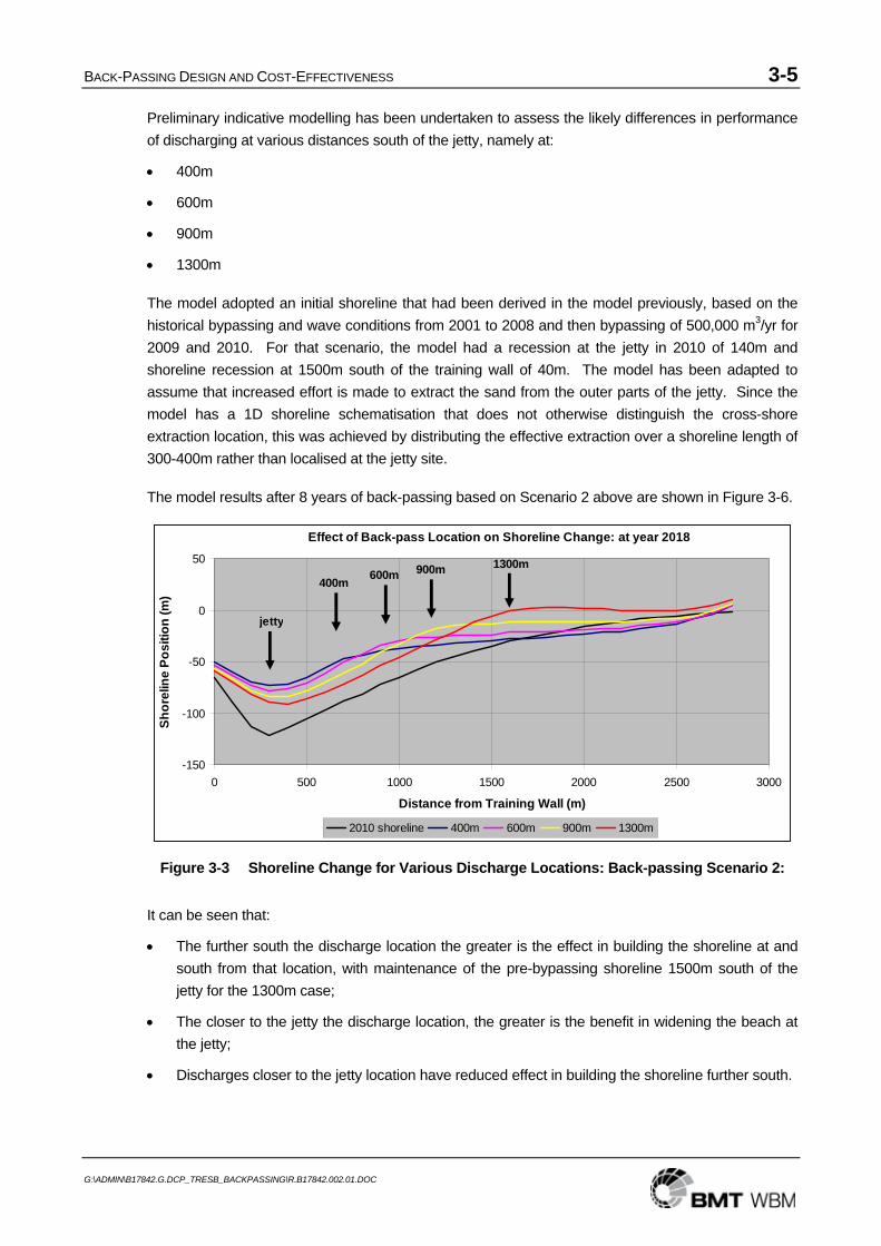
Preliminary indicative modelling has been undertaken to assess the likely differences in performance of discharging at various distances south of the jetty, namely at:
• 400m
• 600m
• 900m
• 1300m
The model adopted an initial shoreline that had been derived in the model previously, based on the historical bypassing and wave conditions from 2001 to 2008 and then bypassing of 500,000 m3/yr for 2009 and 2010. For that scenario, the model had a recession at the jetty in 2010 of 140m and shoreline recession at 1500m south of the training wall of 40m. The model has been adapted to assume that increased effort is made to extract the sand from the outer parts of the jetty. Since the model has a 1D shoreline schematisation that does not otherwise distinguish the cross-shore extraction location, this was achieved by distributing the effective extraction over a shoreline length of 300-400m rather than localised at the jetty site.
The model results after 8 years of back-passing based on Scenario 2 above are shown in Figure 3-6.
Effect of Back-pass Location on Shoreline Change: at year 2018
-150
-100
-50
0
50
0 500 1000 1500 2000 2500 3000
Distance from Training Wall (m)
Shor
elin
e Po
sitio
n (m
)
2010 shoreline 400m 600m 900m 1300m
400m 600m 900m 1300m
jetty
Figure 3-3 Shoreline Change for Various Discharge Locations: Back-passing Scenario 2:
It can be seen that:
• The further south the discharge location the greater is the effect in building the shoreline at and south from that location, with maintenance of the pre-bypassing shoreline 1500m south of the jetty for the 1300m case;
• The closer to the jetty the discharge location, the greater is the benefit in widening the beach at the jetty;
• Discharges closer to the jetty location have reduced effect in building the shoreline further south.

BACK-PASSING DESIGN AND COST-EFFECTIVENESS 3-6
G:\ADMIN\B17842.G.DCP_TRESB_BACKPASSING\R.B17842.002.01.DOC
Selection of the most suitable discharge location would need to take into account all of the relevant considerations. On the basis that an objective of the back-passing would be to maintain the shoreline at and near 1500m south of the jetty at the pre-bypassing location, the more southerly locations would be more suitable. Otherwise, a discharge location at about 900m could be the optimum site.
However, it is not clear that pipeline access at 900m would be acceptable, as there is no easement there. If a choice between the 660m and 1300m easements is to be made, then the optimum location will depend on cost-benefit in the context of all of the adopted back-passing objectives and benefits.
3.2 Benefits and Adverse Impacts
The benefits of back-passing include:
• Assistance in managing the bypassing quantities to cater for the highly variable natural rate of supply of sand to the system on a short (weeks to months) and long (annual) term basis.
• Provision of a mechanism for maintaining the shoreline alignment of Letitia Beach;
• The opportunity to manage widening of the beach at the jetty;
• The opportunity to manage the sand delivery to Queensland in a manner that may be beneficial to the beach conditions and surf quality there, targeted initially at reducing the quantity of sand at Kirra while maintaining acceptable conditions at Snapper Rocks through to Greenmount.
The adverse impacts relate primarily to additional cost and, for the pipeline discharge option:
• the need for pipeline infrastructure along Letitia Spit and across the dune and beach at the discharge location; and
• any environmental impacts associated with the pipeline and/or sand discharge works. This is discussed in Chapter 5 and is not expected to be a significant constraint on the activity, subject to the findings of a Review of Environmental Factors (REF).
Dune damage associated with pipeline installation can be repaired effectively at little cost. A discharge facility on the beach will interfere with local beach use there and travel along the beach.
It is unlikely that there would be significantly increased total pumping and energy use compared with the present situation. This would only be the case potentially if the need for entrance dredging of the increased ‘leakage’ to the mouth is in fact proportionately greater under back-passing than the present 80% as assessed by BMT WBM (2009). However, even in that case, the long term prospects for scaling back the total bypassing offered by the back-passing is potentially beneficial.
3.3 Risks
The primary risk is that the back-passing would not be effective, or that the design initially prepared requires substantial modification and possibly higher costs than anticipated to be effective.
It must be recognised that modelling as a basis for design has significant limitations, although it is the best available assessment tool. This together with the need for monitoring of the performance and reactive optimisation of the design are discussed in Section 3-4.

BACK-PASSING DESIGN AND COST-EFFECTIVENESS 3-7
G:\ADMIN\B17842.G.DCP_TRESB_BACKPASSING\R.B17842.002.01.DOC
There is a significant risk that widening of the beach at the jetty, leading to a more sustainably managed balance of natural sand supply and quantities delivered to Queensland, may not be readily achieved. In the event that this is the case, the strategy of scaling back the back-passing and the total pumping effort over the longer term will be compromised. This will depend on the efficiency of the jetty system in intercepting the sand supply when the beach is widened, with reduced effect of the training wall in trapping sand and the need for the outer pumps to be used with high effectiveness.
It must also be recognised that the annual sand transport rates along Letitia Spit are highly variable and major storm events will substantially alter the upper beach. Back-passing that achieves a particular outcome in one year may have a different outcome in another. There is a risk that, even with a comprehensive monitoring program, premature judgements may be made about the success or failure of a particular back-passing strategy in the absence of a full understanding of the context of the performance in the longer term.
Other potential risks relate to community perceptions and responses to the back-passing. These are difficult to predict. However communication of the key objectives to assist with better management of the bypassing quantities, maintain the Letitia Beach shoreline, reduce excessive beach width at Kirra and help to improve surf quality along southern Gold Coast beaches would be an important factor in proceeding with a back-passing program.
3.4 Monitoring and Management Considerations
Predictive modelling methods for determining a suitable back-passing design have significant limitations and uncertainties. Should implementation of back-passing be pursued, it should be regarded initially on a trial basis, with careful monitoring and flexibility to modify the strategy to achieve optimum outcomes. Further, it should be regarded along with other factors as a possible means of restoring the situation to a more sustainable one in which the rate of transport to the jetty is reduced closer to that passing Fingal.
Because of the uncertainties inherent in predicting the future responses to back-passing, close monitoring of any back-passing undertaken and flexible reactive response in terms of the back-passing location, rate and method are essential.
Such monitoring should include:
• Initially frequent (say monthly) close-spaced (say 50m) profile surveys covering the length of Letitia Spit from the training wall to at least 1km south of the back-passing location, extending at 100m spacing south to Fingal, integrated into the existing profile surveys;
• Corresponding surveys of the river mouth, bar area and Duranbah north to Point Danger, to quantify sand quantities there;
• After one year, consideration and decision about adopting less frequent surveys, reducing to 2-monthly and then (say) 6-monthly;
• Regular sand budget analyses and back-passing performance from each set of surveys, taking account of conditions such as extreme wave events that would influence behaviour;
• Reactive strategy to optimise effectiveness.

BACK-PASSING DESIGN AND COST-EFFECTIVENESS 3-8
G:\ADMIN\B17842.G.DCP_TRESB_BACKPASSING\R.B17842.002.01.DOC
As an operational strategy in setting the Target Quantities and back-passing rates, a longer term (say annual) perspective should be adopted to allow for natural annual, seasonal and event variability without reactive changes. It has been assessed (BMT WBM 2009) that the annual transport rates are highly variable. Back-passing that achieves a particular outcome in one year may have a different outcome in another.
It would be better to prepare a design strategy initially based on the best available information and make fewer changes than to continually change the strategy reactively based on relatively short term (less than a year) results. The trend of behaviour over time, particularly in terms of the sand quantities rather than shoreline position at any particular time, should be adopted as the key performance indicator. However, if the specified back-passing rates are demonstrably too high or too low, variation at a more frequent interval should be possible.
Through this process, with adequate monitoring, a basis for improved control of the rate of delivery to Queensland should be feasible. Thus, the back-passing rate and the delivery to Queensland could be optimised for maximum benefit. To the extent acceptable, this could also be used to balance the longer term sand supply to Queensland and loss from Letitia Spit by correcting past sand oversupply through a period of sand undersupply.
3.5 Cost Assessment
3.5.1 Back-passing Cost
Two hypothetical back-passing scenarios extending over the next 15 years have been developed. These are presented in Appendix A and are for illustrative and indicative costing purposes only. They incorporate an adopted reduction in the sand transport to the jetty in response to beach widening and proportions of the ‘leakage’ to the entrance of 80% dredged versus 20% natural bypassing derived by BMT WBM (2009).
For cost comparison purposes, an equivalent ‘base case’ scenario has been determined without back-passing. This adopts the same total jetty pumping rates and reduction in transport to the jetty as the back-passing scenarios, based on the same assumption that the beach may be widened equivalently at the jetty. This may be unduly ambitious in the absence of back-passing, but is presented primarily for estimation of the incremental cost of the back-passing.
The ability to reduce the back-passing and undertake the bypassing with a sustainable long term balance of quantities supplied naturally and delivered to Queensland depends on beach widening at the jetty and associated reduction in sand transport to the jetty by reduced total jetty pumping. It is to be noted that attempts to design a scenario with constant back-passing from the jetty of 75,000 to 100,000 m3/yr indicated potential difficulties with feasibility in that the efficiency of the jetty system eventually would need to be significantly greater than the presently achieved 67% of the rate of sand transport to the jetty, as determined by BMT WBM (2009). As it is, the required jetty pumping efficiency may not be achieved once the beach at the jetty is widened even under the adopted scenario. In that case, a further shift from jetty pumping to entrance dredging would be needed.
A key feature of the base case scenario is a continuing loss of sand from Letitia Beach and corresponding further net gain to Gold Coast beaches over the period until a sustainable balance of

BACK-PASSING DESIGN AND COST-EFFECTIVENESS 3-9
G:\ADMIN\B17842.G.DCP_TRESB_BACKPASSING\R.B17842.002.01.DOC
average annual quantities is achieved. This is projected in the base case to be about 700,000 m3 over the 15 year scenario period.
A cost summary of the base case and two back-passing scenarios is presented in Table 3-1.
Table 3-1 Summary of Base Case and Back-passing Scenarios Over 15 years
Component Base case Scenario 1 Scenario 2 Transport rate at Fingal 550,000 m3/yr 550,000 m3/yr 550,000 m3/yr Benefit to Letitia Beach - 0.70 M m3 0.95 M m3 0.58 M m3 Pumping to Qld 5.69 M m3 4.20 M m3 4.42 M m3 Pumping to back-passing 1.50 M m3 1.28 M m3 Dredging to Qld 2.60 M m3 2.45 M m3 2.60 M m3 Dredging to back-passing - 0.15 M m3 Natural Bypassing 0.65 M m3 0.65 M m3 0.65 M m3 Bypassed supply to Qld 8.30 M m3 6.65 M m3 7.02 M m3 Total delivery to Qld 8.95 M m3 7.30 M m3 7.67 M m3
3.5.2 Incremental Cost of Back-passing
Cost implications of back-passing need to be considered in the context of the likely alternative operations and costs over the next 15 years. The ‘base case’ presented above has been used herein for cost comparison purposes. The costs of the incremental differences in the jetty pumping and entrance dredging between the base case and the two back-passing scenarios have been determined. The cost rates assigned to those components are:
• Jetty pumping to Queensland: $1.00 per m3;
• Entrance dredging: $15.00 per m3.
There will also be additional costs associated with:
• Installation of the pipeline system along Letitia Spit to the discharge location, adopted to be approximately $1 million;
• Operation and management of the pipeline back-passing and pump-out facility, adopted at a rate of $2 per m3; and
• Extra monitoring in order to assess performance and reactively optimise the back-passing design and implementation, as discussed in Section 3-2.
Assuming a decreasing frequency of additional surveys over time, an incremental cost of the monitoring could be approximately $1.84 million as follows:
• $240,000 per year for the first 2 years;
• $120,000 per year for the following 8 years
• $ 80,000 per year for the last 5 years.
A summary of the estimated costs of the incremental differences in pumping, dredging and monitoring between the adopted scenarios over 15 years is provided in Table 3-2.

BACK-PASSING DESIGN AND COST-EFFECTIVENESS 3-10
G:\ADMIN\B17842.G.DCP_TRESB_BACKPASSING\R.B17842.002.01.DOC
Table 3-2 Incremental Cost of Back-passing Versus Base Case
Scenario 1 Scenario 2 Component Quantity (M m3) Cost ($M) Quantity (M m3) Cost ($M)
Pumping to Qld - 1.49 - 1.49 - 1.27 - 1.27 Pumping to back-passing + 1.50 + 3.00 + 1.28 + 2.56 Dredging to Qld - 0.25 M - 3.75 -0.10 - 1.50 Dredging to back-passing + 0.15 M + 2.25 Capital cost of pipeline + 1.0 +1.0 Additional monitoring + 1.84 + 1.84 TOTAL + 2.85 + 2.63
On that basis, indicatively, the incremental cost of back-passing is dominated by the installation and operation of the pipeline together with the additional monitoring required, with offsets in reduced bypassing to Queensland.

LEGISLATIVE CONSIDERATIONS 4-1
G:\ADMIN\B17842.G.DCP_TRESB_BACKPASSING\R.B17842.002.01.DOC
4 LEGISLATIVE CONSIDERATIONS
4.1 Regulatory and Policy Framework
The following section outlines the regulatory and policy framework applicable to Options 1 and 2, proposed for the sand back-passing and requiring assessment as part of the feasibility study. All activities and infrastructure associated with Options 1 and 2 (including the sand source and location for nourishment) are in NSW, and therefore the NSW legislative framework has been considered in this Chapter. Aspects considered within this assessment include:
• Consistency with project legislation and achievement of project objectives (i.e. that they are met and promoted); and
• Identification of necessary planning approvals and an estimation of the time needed to obtain these approvals.
It should be noted that this information has been provided as an indication of the current requirements and does not constitute legal advice.
4.2 Consistency with Project Legislation and Objectives
Project legislation has been enacted within both Queensland and NSW for the Tweed River Entrance Sand Bypassing Project (TRESBP), with most clauses, the Deed of Agreement and the Heads of Agreement mirrored within each State’s statutes. In NSW, the project legislation is the Tweed River Entrance Sand Bypassing Act 1995 No. 55 (TRESB Act).
4.2.1 Purpose and Objectives
The purpose of the TRESB Act is to provide for the carrying out of agreements between NSW and Queensland with regard to:
• the improvement of the navigability of the Tweed River entrance; and
• the bypassing of sand around the Tweed River entrance so that it can replenish the southern Queensland beaches (s3); and
• for related purposes.
Within the Deed of Agreement (Schedule 1, TRESB Act), the purpose of the Project is to “…enhance and maintain the attributes of the Gold Coast – Tweed Heads region and more specifically the Tweed River estuary and southern Gold Coast beaches and to achieve the respective objectives of the Parties.”
The objectives set out in the Deed of Agreement are:
• for NSW - to establish and maintain a navigable depth of water of at least 3.5 metres below Indian Spring Low Water (ISLW) in the approach to and within the entrance channel to the Tweed River over a width equal to that between the rubble mound breakwaters; and

LEGISLATIVE CONSIDERATIONS 4-2
G:\ADMIN\B17842.G.DCP_TRESB_BACKPASSING\R.B17842.002.01.DOC
• for Queensland - to achieve a continuing supply of sand to the Southern Gold Coast beaches at a rate consistent with the natural littoral drift rates updrift and downdrift, together with the supply of such additional sand to the beaches as is required to restore the recreational amenity of the beaches and to maintain it.
These objectives are required by the Deed of Agreement to be achieved in perpetuity. The primary objective of the back-passing is to restore the shoreline alignment along Letitia Beach to that required under the Concession Agreement between the Governments and the bypass contractor TRESBCo. However, in light of the excessive delivery of sand to Queensland and the impact it has had on beach and surf quality, it is considered that back-passing would meet the objectives of both States if it achieved a better balance of sand delivery to Queensland and could be used to manage an improvement in beach and surf quality.
Two back-passing options are considered:
• Option 1: installation and use of a sand delivery pipeline and outlet to pump sand to Letitia Spit beach; and
• Option 2: back-passing by floating dredge to remove sand directly from the Tweed River entrance providing maintenance of a channel at 3.5m ISLW, while allowing sand to be delivered to the beaches in southern Queensland.
It has been pointed out above that there has been an excess of sand delivered to Queensland by bypassing and natural transport to date. This has been attributed to a combination of:
• An excessive Supplementary Increment as specified by the Deed of Agreement; and
• Operational bypassing in excess of the Long Term Average.
While the surplus delivery associated with the Supplementary Increment may not be offset without some form of special agreement between the States, back-passing would provide an opportunity to manage the quantities back-passed and bypassed to try to restore more suitable conditions, at least to the extent of the excess over the Long Term Average.
4.2.2 Applicable Definitions within the Act
Under the Deed of Agreement, “Project” is defined as meaning the TRESBP, partially comprised of the “System” (meaning “Artificial Sand Bypassing System”) and including “Additional Works”.
The “System” is defined as:
the works as described in the Heads of Agreement to be established pursuant to this Agreement for the hydraulic or mechanical movement of sand in perpetuity from within the Tweed River Bar and Entrance Area on the updrift side to the Beaches on the downdrift side of the Tweed River entrance other than by natural processes and includes all necessary preliminary and ancillary activities, any interim works that the Parties agree to establish for that purpose and any replacement of the works which may be necessary from time to time to meet the purpose of this Agreement but does not include any works associated with the Initial Dredging Component.
While the definition does not explicitly consider the artificial movement of sand to beaches on the updrift side (e.g. Letitia Spit beach), the movement of sand as part of the proposed back-passing can

LEGISLATIVE CONSIDERATIONS 4-3
G:\ADMIN\B17842.G.DCP_TRESB_BACKPASSING\R.B17842.002.01.DOC
be considered an …”ancillary activity, …(or) interim works that the Parties agree to establish for that purpose…”. The back-passing would only be a temporary placement of sand to the south and, in time, the sand would move back into the TRESBP area prior to (likely) being artificially transported across the Tweed River entrance. In addition, within the Heads of Agreement, the “Scope of Works” for the “Permanent Bypass” (Schedule 2, cl. 5.2) component considers that the “system” will have to take into account coastal process issues as they relate to the Beaches1, the river entrance, Duranbah Beach and to Letitia Spit, as well as to beach usage criteria and navigation requirements.
The “System” also considers “the works”. The TRESB Act defines “the works” as “the works to be carried out, maintained or constructed to give effect to the deed of agreement and any further agreement” (s4). The design purpose of the back-passing as described in Chapter 3 would thus be consistent with the purpose and objectives of the Deed of Agreement.
“Additional works”, as part of the “Project”, means the works which the Ministerial Council agrees to include as part of the Project pursuant to cl. 11.” This clause outlines that activities incidental to the Project may identify works which must be undertaken in accordance with all legal requirements (cl. 11.1). As the background to the brief for the current study outlined that the feasibility assessment has been initiated by the Ministers of NSW and Queensland, it is considered that any back-passing works would be agreed by the Ministerial Council to be included as part of the Project. If not considered part of the project, the Ministerial Council may agree to include as part of the Project works which would not otherwise be part of the Project (cl. 11.2). Further, all works will be undertaken in accordance with relevant approval requirements.
Based on the application of the definitions of “System” and “Additional works” to the proposed sand backpassing arrangement, it is considered that both Options 1 and 2 would be consistent with, and come within the definition of, the “Project” under the TRESB Act.
4.2.3 Sand Volumes
The Heads of Agreement also considers that if the Long Term Average (LTA) sand transport rate changes, the rate of delivery will be changed accordingly (cl. 5.2). Any such reassessment of the LTA would be based on the analysis of the sand transport rates, performance of the bypassing and the its effect on the natural bypassing, taking account of the measured changes to the sand quantities and shoreline changes that have occurred. The present LTA rate is 500,000 m3/yr. Changes to that rate would not be expected to impact on the feasibility of back-passing, but may affect the required rate of delivery to Queensland.
There is provision for the quantity delivered by the bypassing to vary from year to year while being equal to the LTA over time. The time over which the delivery rates may exceed or be less than the LTA are not specified in the legislation. It is known that the quantity delivered to date exceeds the quantity equivalent to the LTA. There may be scope for a reduced delivery for some future time to compensate for that surplus within the provisions of the legislation. Any additional reduction would not be consistent with those provisions and would need some form of special agreement between the States.
1 Beaches, for the purposes of the “System”, means Duranbah Beach, Snapper Rocks, Kirra Point or in their vicinity.

LEGISLATIVE CONSIDERATIONS 4-4
G:\ADMIN\B17842.G.DCP_TRESB_BACKPASSING\R.B17842.002.01.DOC
4.3 Planning Approvals
Legislation and other policy and planning instruments relevant to the planning approval process are outlined in this section, as well as the statutory timeframe for assessment and approval processes where these apply.
Table 4-1 summarises the planning approvals and considerations outlined in this section.
Table 4-1 Summary of Relevant Planning Approvals
Instrument Option 1 Option 2
TRESB Act • Development according to EP&A Act
• Outlines exception to development approval and land acquisition process
• Development according to EP&A Act • Outlines exception to development
approval and land acquisition process
EP&A Act • Assessed under Part 5 • Assessed under Part 5 SEPP Infrastructure • Works related to ‘waterway or
foreshore management activity’ permitted without consent - therefore assessed under Part 5
• Works related to ‘waterway or foreshore management activity’ or ‘port, wharf or boating facilities’ permitted without consent – therefore assessed under Part 5
SEPP 14 - - SEPP 71 • Provisions to be considered for
development on coastal lands • Provisions to be considered for
development on coastal lands North Coast REP • Provisions to be considered for
development in North Coast region • Provisions to be considered for
development in North Coast region Tweed LEP 2000 ( and Draft Tweed LEP 2010)
• Provisions relating to each zone to be considered for development
-
FM Act - - POE Act • Consider a ‘precautionary’
environmental protection licence • Consider a ‘precautionary’
environmental protection licence Coastal Protection Act • Concurrence of Minister
• Works conducted in accordance with Tweed Coastline Management Plan 2005
• Consideration of NSW Coastal Policy
• Concurrence of Minister • Works conducted in accordance with
Tweed Shire Coastline Management Plan 2005
• Consideration of NSW Coastal Policy
WM Act - - NSW Maritime approval - Navigational requirements Heritage Act • Excavation permit for non-listed
heritage • Permit for listed heritage if
necessary
-
National Parks and Wildlife Act
• Permit potentially required -
EPBC Act • Precautionary referral to DEWHA may be considered necessary
• Precautionary referral to DEWHA may be considered necessary

LEGISLATIVE CONSIDERATIONS 4-5
G:\ADMIN\B17842.G.DCP_TRESB_BACKPASSING\R.B17842.002.01.DOC
4.3.1 TRESB Act 1995
As the project legislation, the TRESB Act establishes the framework under which Project-related development is assessed and approved.
“Development”, for the purposes of s10 of TRESB Act, is the same as under the Environmental Planning and Assessment Act 1979 (EP&A Act). This is a broad definition that includes the use of land, the carrying out of work, or any other act, matter or thing referred to in section 26 of that Act that is controlled by an environmental planning instrument. Options 1 and 2 fall within this definition for the purposes of the proposed back-passing. Section 10(2) outlines that development for the purposes of the works may be carried out without the necessity for development consent under Part 4, EP&A Act, even if the development would be prohibited or require consent in absence of that section. Further, s10(3) outlines that any development is an activity within the meaning of Part 5, EP&A Act and that the Minister is the determining authority for the purposes of that Part. Refer below for further information on the assessment process under that Act.
In carrying out the works (the works as defined in s4), s9 of the TRESB Act provides for exceptions in the development approval and land acquisition process. These are:
• The works are taken to be an authorised work and any land required may be acquired under s39 Public Works Act 1912 (a compulsory process in accordance with the Land Acquisition (Just Terms Compensation) Act 1991).
• Restrictions on dealing with land subject to native title within s42 Aboriginal Land Rights Act 19832 do not apply to the acquisition of land for the purposes of carrying out the works under the TRESB Act.
• If the Minister, in making submission to the Governor for notice by gazette, can establish that, for the purpose of the works, it is not necessary to follow the formal process of approval of acquisition, notice, minimum period, and withdrawal of acquisition (ss11-18) under Land Acquisition (Just Terms Compensation) Act 1991, then these processes need not apply to acquisition under the TRESB Act.
• No consent or permission is required under the Crown Lands Act 1989 to acquire land nor is the Minister required to be qualified under this Act to hold tenure of the land acquired;
• None of the provisions of the Pipelines Act 1967 apply to works under the TRESB Act.
4.3.2 Environmental Planning and Assessment Act 1979
The EP&A Act establishes the framework for environmental assessment of development in NSW through Part 3A, 4 and 5 of the Act. Planning instruments under this Act include State Environmental Planning Policies (SEPPs) and Local Environment Plans (LEPs). According to the TRESB Act, Part 5 applies to the assessment of development for the carrying out of works undertaken under the EP&A Act.
For the purposes of the current study, the application of Part 3A was also considered3. However, the State Environmental Planning Policy (Major Developments) 2005 which identifies projects to which
2 An Aboriginal Land Council must not deal with land vested in it subject to native title rights and interests under section 36 (9) or (9A) Aboriginal Land Rights Act 1983, unless the land is the subject of an approved determination of native title.

LEGISLATIVE CONSIDERATIONS 4-6
G:\ADMIN\B17842.G.DCP_TRESB_BACKPASSING\R.B17842.002.01.DOC
Part 3A applies (s6; see Schedules 1-3 and 5), does not identify any project relevant to the sand back-passing proposal. Therefore Part 5 applies to the proposed sand back-passing.
For Part 5 to be activated, there must be an activity and the activity proposed is to be undertaken by a determining authority or require the approval of a determining authority:
• The definition of “activity” (s110) is defined the same as “development” (with some exclusions). Further, s10(3) outlines that a development (as defined within the EP&A Act) is an activity within the meaning of Part 5.
• Section 19(3) TRESB Act states that the Minister is the determining authority in relation to the activity for the purposes of Part 5.
Therefore both Options 1 and 2 would be able to be assessed under Part 5, EP&A Act.
In considering an activity, the determining authority has a twofold obligation4:
• A duty to take into account to the fullest extent possible all matters affecting or likely to affect the environment by reason of that activity (s111(1)) Specifically this includes, but is not limited to, consideration of:
• critical habitat;
• in the case of threatened species, populations and ecological communities, and their habitats, whether there is likely to be a significant effect on those species, populations or ecological communities, or those habitats, and
• any other protected fauna or protected native plants within the meaning of the National Parks and Wildlife Act 1974.); and
• A duty to consider an EIS if the activity is likely to significantly affect the environment, including critical habitat or threatened species, populations or ecological communities, or their habitats (s112(1)).
In order to determine when an EIS is required, a determining authority usually considers a preliminary environmental assessment called a “Review of Environmental Factors” (REF). While the REF has no statutory basis, it is required as part of the standard practice of the Department of Planning and other public authorities which are bound by Part 5.
If an EIS is deemed necessary, it must be prepared in accordance with Schedule 2 of the EP&A Regulations, and take into account the an extensive list of factors outlined in cl. 288(1) EP&A Regulations.
If the activity is on land that is critical habitat or is likely to significantly affect threatened species, populations or ecological communities or their habitats, then a species impact statement (SIS) may also be required (s112(1B)). This involves a seven part assessment provided in s5A(2) of the Act:
3 Part 3A was not enacted at the time the TRESB Act was last reviewed. Part 3A projects are not subject to Part 5 (ss75R(1), 110(2)). 4 Note that certain exemptions apply to the duties under s111 and s112 EP&A Act.

LEGISLATIVE CONSIDERATIONS 4-7
G:\ADMIN\B17842.G.DCP_TRESB_BACKPASSING\R.B17842.002.01.DOC
1. In the case of a threatened species, whether the action proposed is likely to have an adverse effect on the life cycle of the species such that a viable local population of the species is likely to be placed at risk of extinction,
2. In the case of an endangered population, whether the action proposed is likely to have an adverse effect on the life cycle of the species that constitutes the endangered population such that a viable local population of the species is likely to be placed at risk of extinction,
3. In the case of an endangered ecological community or critically endangered ecological community, whether the action proposed:
a. is likely to have an adverse effect on the extent of the ecological community such that its local occurrence is likely to be placed at risk of extinction, or
b. is likely to substantially and adversely modify the composition of the ecological community such that its local occurrence is likely to be placed at risk of extinction,
4. In relation to the habitat of a threatened species, population or ecological community:
a. the extent to which habitat is likely to be removed or modified as a result of the action proposed, and
b. whether an area of habitat is likely to become fragmented or isolated from other areas of habitat as a result of the proposed action, and
c. the importance of the habitat to be removed, modified, fragmented or isolated to the long-term survival of the species, population or ecological community in the locality,
5. Whether the action proposed is likely to have an adverse effect on critical habitat (either directly or indirectly),
6. Whether the action proposed is consistent with the objectives or actions of a recovery plan or threat abatement plan,
7. Whether the action proposed constitutes or is part of a key threatening process or is likely to result in the operation of, or increase the impact of, a key threatening process.
On the basis of the EIS and consideration of the environmental impacts, the determining authority may then approve the activity subject to conditions or modifications to mitigate or eliminate the detrimental impacts, or refrain from undertaking the activity (s112(4)).
Based upon the preliminary information provided in Chapter 5, it is possible the proposed back-passing may require an EIS and SIS for listed threatened species such as the Little Tern. An environmental assessment should therefore be carried out through a Review of Environmental Factors (REF).
Timing
The determining authority for a project must consider environmental impacts and aspects of the project in detail (s111). Where these will cause significant environmental impacts an EIS is to be

LEGISLATIVE CONSIDERATIONS 4-8
G:\ADMIN\B17842.G.DCP_TRESB_BACKPASSING\R.B17842.002.01.DOC
submitted (s112). Upon submission, the determining authority will need to consult with the Minister administering the Threatened Species Conservation Act 1995 and the Director-General of the Department of Environment, Climate Change and Water where these bodies are relevant (ss112A-112E). The EIS must be placed on public exhibition for at least 30 days, during which time the public can make submissions, and then a submission is to be made to the Director-General 21 days before approval can be offered (s113).
Environmental Planning Instruments
A number of Environmental Planning Instruments (EPIs) have been considered in the current study. These include:
• State Environmental Planning Policy (Infrastructure) 2007: This SEPP aims to facilitate delivery of infrastructure across the State. It also repealed the SEPP 35 – Maintenance Dredging of Tidal Waterways. However, SEPP (Infrastructure) 2007 considers infrastructure related to “Port, wharf or boating facilities” and “Waterway or foreshore management activities”. While maintenance dredging is not explicitly mentioned within these sections of the SEPP, it is likely that provisions within these divisions identify ‘development permitted without consent’, which is likely to cover maintenance dredging (ss68 and 129)5. The back-passing would not be considered maintenance dredging.
• State Environmental Planning Policy No. 14 – Coastal Wetlands: All development in areas classed as coastal wetlands under SEPP 14 cannot involve land clearance, construction of levees, drainage or filling except with the consent of the council and concurrence from the Director. The proposed area for works under Options 1 and 2 is not within or in an area where works will impact on a SEPP 14 wetland.
• State Environmental Planning Policy No. 71 – Coastal Protection: The provisions of SEPP 71 must be taken into account by the consent authority when determining an application for development on coastal lands. The matters that must be considered include:
o Retaining public access to and along the coastal foreshore for pedestrians
o Providing opportunities for new public access on the foreshore
o Any detrimental impact that development may have on the amenity of the coastal foreshore
o The scenic qualities of the NSW coast
o Measure to conserve threatened animals, plants and fish
o Protecting existing wildlife corridors, and
o The likely impact of coastal processes and coastal hazards on development. SEPP 71 defines all development within 100m below mean high water mark as significant coastal development. Development controls can be put in place by the relevant authority to ensure the above considerations are enforced.
5 Backpassing development may be classified as development without consent under both Part 3 Division 13 (Port, wharf or boating facilities) and Division 25 (Waterway or foreshore management activities). Under Division 13, the works would mostly likely fall under s68(2)(a) or (b) where s68(5) is deemed to apply to the works. Under Division 25, the works would most likely fall under s129(a) and (b) where the definitions in s128(c) are deemed to apply to the works.

LEGISLATIVE CONSIDERATIONS 4-9
G:\ADMIN\B17842.G.DCP_TRESB_BACKPASSING\R.B17842.002.01.DOC
• North Coast Regional Environmental Plan: (now a deemed SEPP): The provisions of the REP must be taken into account by the consent authority when determining an application for development on or in the North Coast region.
• Tweed Local Environmental Plan 2000: The Tweed Local Environment Plan 2000 (Tweed LEP) provides the zoning for the land that is the subject of the proposed works and identifies the permissibility of development for each zone. The zones potentially impacted at Letitia Spit are:
o Zone 7(d) Environmental Protection (Scenic/Escarpment) which aims to ensure that the development of land within this zone minimises soil erosion and will preserve or enhance the scenic quality of the land and the locality; and
o Zone 7(a) Environmental Protection (Wetlands and Littoral Rainforests) which aims to ensure that wetlands and littoral rainforests are preserved and protected in the environmental and economic interests of the area of Tweed.
The LEP requires that within Zone 7(d), no clearing of vegetation from, excavating or erecting a building on land within Zone 7 (a) may occur except with development consent. A similar limitation occurs within Zone 7(d) for the clearing of vegetation from, draining, excavating or filling of land, however additionally the LEP requires (s25) that consent must not be granted to the carrying out of development on land within Zone 7 (a) or on land adjacent to land within Zone 7 unless the consent authority has taken into consideration:
o the likely effects of the development on the flora and fauna found in the wetlands or littoral rainforest, and
o the potential for disturbance of native flora and fauna as a result of intrusion by humans and domestic and feral animals, increased fire risk, rubbish dumping, weed invasion and vegetation clearing, and
o a plan of management showing how any adverse effects arising from the development can be mitigated, and
o the likely effects of the development on the water table, and
o the effect on the wetlands or littoral rainforest of any proposed clearing, draining, excavating or filling.
The Tweed LEP also considers land that is subject to coastal erosion outside of Zone 7(f) (s36) and protection of heritage items and conservation areas (Part 8). Further, where a proposed development is likely to have a significant social or economic impact, the consent authority may grant consent to the proposed development only if it has considered a socio-economic impact statement in respect of the proposed development (s17).
It should be noted that the Draft Tweed LEP 2010 is in preparation and will undergo a public exhibition phase prior to being amended and introduced. Consideration of the provisions of the new LEP may be required at this time.

LEGISLATIVE CONSIDERATIONS 4-10
G:\ADMIN\B17842.G.DCP_TRESB_BACKPASSING\R.B17842.002.01.DOC
4.3.3 Fisheries Management Act 1994
The Fisheries Management Act 1994 (FM Act) aims to conserve, develop and share the fishery resources of the state for the benefit of present and future generations, and applies specifically to aquatic flora and fauna; primarily fish, invertebrates and some algae.
Under sections 200 and 201 of the FM Act, a permit is required from NSW Fisheries by any person or local government authority performing dredging or reclamation work unless the work is authorised under the Crown Lands Act 1989 or is authorised by a relevant public authority. Dredging is also covered by the Fish Habitat Protection Plan No. 1: General (NSW Fisheries, 1995).
With regard to the use of dredging for the proposed back-passing, the work will not require approval under the FM Act assuming the works are authorised by a relevant public authority. It is also possible that dredging is already approved under the TRESBP, however resolution of this issue will require clarification.
The FM Act also states (s205) that a person must not remove, damage or destroy marine vegetation except under the authority of a permit issued by the Minister. Removal or damage to seagrass is also covered by the Fish Habitat Protection Plan No. 1: General (NSW Fisheries 1995) and Fish Habitat Protection Plan No. 2: Seagrasses (NSW Fisheries 1997).
In the event that seagrass will be removed, damaged or destroyed as a result of the proposed backpassing, a permit from NSW Fisheries will be required. However, as the Tweed River entrance is regularly dredged, it is unlikely that seagrasses occur within the dredge footprint or along the open coastline where the material will be placed. Therefore, no permit is considered necessary for potential damage to marine plants.
Timing
Where approval is required, written notice of the proposed work must be provided to the Minister and the relevant authority undertaking the dredging must respond to any matters concerning the proposed work raised by the Minister within 28 days after giving the notice (s199(1)). Where the authority chooses to not address issues raised by the Minister they must notify the Minister of this in writing. The Minister must then refer any dispute to the Minister responsible for the public authority to resolve within 14 days (s199(2)). If the Ministers fail to resolve the dispute it is to be referred to the Premier for resolution. A permit may then be issued.
4.3.4 Protection of the Environment Operations Act 1997
The Protection of the Environment Operations Act 1997 (POE Act) seeks to protect, restore and enhance the quality of the existing environment in the context of ESD, reduce risks to human health and prevent degradation of the environment.
Schedule 1 POE Act lists activities that require a licence from the EPA. The dredging of more than 30,000m3 annually of extractive material (which includes sand) that is to be re-used constitutes a scheduled activity. The proposed back-passing will maintain the material within the active system, and therefore it is not considered to be removed for re-use.

LEGISLATIVE CONSIDERATIONS 4-11
G:\ADMIN\B17842.G.DCP_TRESB_BACKPASSING\R.B17842.002.01.DOC
However, under s120 POE Act a person who pollutes any waters is guilty of an offence. To pollute waters includes causing or permitting any waters to be polluted. However, it is a defence in proceedings against a person for an offence under this Part if the person establishes that (s122):
• the pollution was regulated by an environment protection licence held by the person or another person, and
• the conditions to which that licence was subject relating to the pollution of waters were not contravened.
While there is limited potential to cause water pollution during the back-passing operations for Options 1 and 2, and if the TRESBP is not already licensed to include such activities (i.e back-passing), a licence may be applied for under the POE Act as a precautionary measure.
Timing
Licence applications are made to the relevant regulatory authority. This body may then accept or refuse the licence. Under s6(3) of the POE Act the EPA is identified as the relevant regulatory authority for unscheduled works other than those listed in the regulations. There is no statutory timeline associated with this activity.
4.3.5 Coastal Protection Act 1979
The Coastal Protection Act 1979 provides for protection of the coastal environment of the State for both present and future generations. The Act defines the “coastal zone” and outlines the types of development that are regulated including the clearing of vegetation and the carrying out of works regulated within the coastal zone (s37).
Section 38(1)(a) of the Act requires that a public authority shall not, without the concurrence of the Minister, carry out any development in the coastal zone if the development:
• is inconsistent with the principles of ecologically sustainable development; or
• will adversely affect the behaviour or be adversely affected by the behaviour of the sea or an arm of the sea or any bay, inlet, lagoon, lake…; or
• will adversely affect any beach or dune or the bed, bank, shoreline, foreshore, margin or flood plain of the sea or an arm of the sea or any bay, inlet, lagoon, lake….
For the purposes of the Coastal Protection Regulation 2004, cl. 5(1) defines the coastal zone as the area below the mean high water mark, excluding any estuary, lake or artificial harbour. Clause 6 outlines that a person (including a public authority) must not, without the concurrence of the Minister, carry out or grant consent for a person to carry out development on any part of the coastal zone to which this Regulation applies.
The Tweed Shire Coastline Management Plan 2005 (Umwelt 2005) provides for the protection and preservation of beach environments and amenity. According to s55K Coastal Protection Act, it is an offence to carry out work relating to beach erosion, except in accordance with the applicable coastal zone management plan. In general, the Tweed Coastline Management Plan 2005 provides for management actions that protect this area of the coastline due to the relative isolation of this area. Specific management actions for this part of the coastline are also identified in Figure 4-1.

LEGISLATIVE CONSIDERATIONS 4-12
G:\ADMIN\B17842.G.DCP_TRESB_BACKPASSING\R.B17842.002.01.DOC
Figure 4-1 Management Actions from the Tweed Shire Coastline Management Plan 2005 (Umwelt 2005)

LEGISLATIVE CONSIDERATIONS 4-13
G:\ADMIN\B17842.G.DCP_TRESB_BACKPASSING\R.B17842.002.01.DOC
Although a non-statutory document, the NSW Coastal Policy is also required to be taken into consideration when determining development applications in coastal local government areas such as the Tweed (cl.92 EP&A Regulation 2000).
Timing
Concurrence from the Minister for works by a public authority regarding the coastal zone is to be given within 40 days of application in writing unless the Minister provides by written notice that a longer period of consideration is needed (ss40-42). Where a decision is not made in the time period, concurrence is not needed (ss40-42).
4.3.6 Water Management Act 2000
The objects of the Water Management Act 2000 (WM Act) include to ‘protect, enhance and restore water sources, their associated ecosystems, ecological processes and biological diversity and their water quality’. Under s91E of the Act, a person who carries out a controlled activity in, on or under waterfront land, and who does not hold a controlled activity approval for that activity is guilty of an offence. Waterfront land is defined as land within 40m of a river, lake or estuary. A controlled activity includes the removal of material (whether or not extractive material) or vegetation from land, whether by way of excavation or otherwise. However, s39A of the Water Management (General) Regulation 2004 exempts public authorities from s91E.
Therefore, if the pipeline alignment or other works come within 40m of the estuary or other water body on Letitia Spit, but it is carried out by a public authority, then no permit will be required under the Act.
Timing
The Minister will declare the appropriate period for public review and objections before submitting the application to the Planning Assessment Commission (ss93-94). The Minister is then to either approve or reject the application. Approval takes effect 28 days after it is made assuming no appeals.
4.3.7 Approval from NSW Maritime
NSW Maritime is a State Government agency responsible for the safety of users of NSW navigable waters, the protection of the marine environment and the provision of waterways infrastructure for vessels.
If the works are likely to be a hazard to navigation, then approval from the agency may be required. However, it is possible that a relevant approval already exists for the TRESBP and could be used for the current proposed back-passing. Any implementation of Option 2 involving dredging would require clarification of this requirement.
4.3.8 Heritage Approvals
Natural, cultural and built heritage is protected under the Heritage Act 1977, while indigenous heritage items or places are protected under the National Parks and Wildlife Act 1974. Indigenous heritage items or places can also be protected through listing on the State Heritage Register or under an interim protection order.

LEGISLATIVE CONSIDERATIONS 4-14
G:\ADMIN\B17842.G.DCP_TRESB_BACKPASSING\R.B17842.002.01.DOC
Aboriginal and post-contact heritage was considered in the EIS undertaken for the TRESBP, and a search of the State Heritage Register was undertaken as part of the current study. No known heritage items were recorded in the vicinity of the proposed back-passing works (Option 1). The sand source areas (Tweed River entrance and intake at the pipeline) have both been previously disturbed and are unlikely to require any further consideration. Placement of material on the beach under Option 2 is also considered unlikely to impact any protected heritage.
However, in relation to the area proposed to be excavated for the construction of the proposed pipeline under Option 1, the following may need to be considered:
• a permit to demolish, move, alter, or in some way develop a place or land covered by an interim protection order or a State Heritage Register listing under s57 Heritage Act 1977;
• an excavation permit under s139 Heritage Act 1977 where, in undertaking the works, a relic may be discovered, exposed, moved, damaged or destroyed (i.e. for works, relics and places not subject to interim heritage orders or State Heritage Register listing);
• a permit may under s87 or s90 National Parks and Wildlife Act 1974 in relation to potential disturbance or destruction of Aboriginal objects or places.
Timing
Regarding a permit to deal with a place or land covered under an interim protection order under s57 of the Heritage Act 1977, application must be made to the approval body which will make the application available to public submission for 21 days (ss59-61). After this period the approval is to make a decision regarding the submissions any other considerations (ss62-63). Application for a permit for excavation works under s139 is made to the Heritage Council which is to approve or reject the permit within 21 days (ss140-141). Where this is failed the permit is deemed to have been rejected (s141).
Applications under the National Parks and Wildlife Act 1974 ss87 and 90 make an application to the Minister or Director-General for approval at their discretion.
4.3.9 Commonwealth Environment Protection and Biodiversity Conservation Act 1999
Under the Commonwealth Environment Protection and Biodiversity Conservation Act 1999 (EPBC Act) referral to the Commonwealth Department of Environment, Water, Heritage and the Arts (DEWHA) is required for actions that have or are likely to have a significant impact on a matter of national environmental significance (NES). Matters of NES within the area of the proposed works that may need to be considered in determine whether referral, assessment and approval are required include:
• Listed threatened species; and
• Migratory species.
Following referral, if the works were determined to be a ‘controlled action’, approval would be required from DEWHA before the works could commence.

LEGISLATIVE CONSIDERATIONS 4-15
G:\ADMIN\B17842.G.DCP_TRESB_BACKPASSING\R.B17842.002.01.DOC
Timing
Once an application for a proposed action is made the Minister must make a decision within 20 business days. The application may either be accepted as a controlled action or not controlled action, or found to be unacceptable. Controlled activities may be assessed by state/territory process (i.e. accredited EIS process), referral information, preliminary documentation, EIS/PER or public inquiry.
State/territory process requires a decision within 30 business days of receiving the assessment report. Referral information assessment includes a 30 business day period for the preparation of a recommendation. Once a recommendation is prepared, a decision must be made within 20 business days. Assessment by preliminary documentation, EIS/PER and public inquiry all have a 40 business day period for the Minister to make a decision following final documentation, EIS/PER and public inquiry, respectively.

ENVIRONMENTAL AND SOCIAL ISSUES 5-1
G:\ADMIN\B17842.G.DCP_TRESB_BACKPASSING\R.B17842.002.01.DOC
5 ENVIRONMENTAL AND SOCIAL ISSUES
5.1 Environmental Considerations
The proposed sand back-passing option will involve the installation of infrastructure through coastal dune habitats along the northern end of Letitia Spit. These habitats are known to support a number of threatened and protected species and wetlands of local and state significance. These natural assets are protected by local, State and Commonwealth legislation and will require careful assessment and consideration prior to any detailed development design.
Letitia Spit is backed by the Tweed River and associated estuary. A permanently inundated embayment, Kerosene Inlet, extends into the dunes adjacent to the proposal (across Leititia Rd). The back-passing infrastructure will be contained along the existing road corridor and laterally along an easement across the narrow dunal habitat between Letitia Road and the beach frontage, currently unmaintained beach access tracks from Letitia Road. These tracks are wide enough to allow vehicle passage.
5.1.1 Terrestrial Flora
Much of Letitia Spit can be considered a highly modified environment as a result of sand mining from the 1930’s to 1960’s. Mining resulted in the loss of extensive areas of native coastal dune vegetation and reconfiguration of the dune topography to a flatter profile. Following mining these areas were seeded with a low diversity of native and introduced species for rapid dune stabilization. Subsequent reforestation has included horsetail oak Casuarina equisetifolia and several exotic species. Remnant stands of coast banksia Banksia integrifolia are still found along the spit (TRESBP EIS 1997).
Native vegetation communities to the south of Wommin Lake, beyond the extent of the proposed backpassing, were also partially cleared prior to the 1970’s. The majority of the swamp oak wetlands to the south of Wommin Lake have been relatively undisturbed.
Letitia Spit is now composed of a mosaic of exotic and regenerating vegetation communities and habitats, with remnant littoral rainforest adjacent to Final Village. Vegetation communities previously recorded on areas of the Spit and likely to be found within the area affected by the back-passing proposal include dune and hind-dune species such as:
• Grassland / mixed re-growth;
• Coast banksia woodland to open forest;
• Mallee low woodland to low open forest;
• Closed heath;
• Sedgeland; and
• Native re-growth (comprised of black sheoak shrubland and mixed re-growth).
Other vegetation communities found on the Spit, though are considered unlikely to fall within the footprint of the back-passing proposal, include:
• Broad-leaved paper bark wetland;

ENVIRONMENTAL AND SOCIAL ISSUES 5-2
G:\ADMIN\B17842.G.DCP_TRESB_BACKPASSING\R.B17842.002.01.DOC
• Coast tea tree low open forest;
• Swamp oak closed forest;
• Littoral rainforest; and
• Mangrove closed forest.
Several rare and threatened flora species occur, largely restricted to the littoral rainforest remnant south of Fingal Village.
5.1.2 Marine Flora
The greater Tweed estuary contains a mosaic of mangrove, saltmarsh and seagrass wetlands. Mapping for the original TRESBP EIS (1997) recorded seagrass meadows within Kerosene Inlet. No mangrove or saltmarsh communities were mapped within the proposal footprint (no additional field work has been conducted to confirm any recent changes).
The proposed discharge zone, the nearshore zone of South Head beach, is dominated by soft sand habitat. Benthic faunal investigations were conducted in 1997, reporting a depauperate community, typical of this type of ephemeral, dynamic habitat. Nevertheless, this habitat provides important foraging ground to mobile species such as whiting Sillago ciliate and bream Acanthopagrus australis.
5.2 Fauna
Letitia Spit and nearby Tweed Estuary is known to support eleven threatened species: ten waterbirds and a bat. The greater Tweed Estuary is known to host at least 74 species of waterbird, including 23 migratory waders, some of which are protected under international bilateral agreements (e.g. Japanese-Australia Migratory Bird Agreement and CAMBA).
The endangered Little Tern Sterna albifrons is a migratory species known to frequent South Beach. They nest above the high tide line, and have suffered significant habitat loss throughout their range due to beach development and human disturbance. The Little Tern was a key consideration in the EIS/IAS for the TRESBP and may need particular attention in relation to the beach discharge for the back-passing. An REF would identify any such issues and any need for an EIS.
Threatened marine fauna such as the green turtle Chelonia mydas, loggerhead turtle Caretta caretta and bottlenose dolphin Tursiops truncatus are likely to utilise the areas to either side of the Tweed River entrance, and lower estuary as feeding grounds. The beaches are not known nesting sites for marine turtles (TRESPB EIS 1997).

ENVIRONMENTAL AND SOCIAL ISSUES 5-3
G:\ADMIN\B17842.G.DCP_TRESB_BACKPASSING\R.B17842.002.01.DOC
Table 5-1 Threatened Species Recorded on Letitia Spit or Adjacent Estuary (NPWS 2010)
Scientific name Common name Legal status
Esacus neglectus Beach Stone-curlew E4A
Charadrius leschenaultia Greater Sand-plover V
Charadrius mongolus Lesser Sand-plover V
Ephippiorhynchus asiaticus Black-necked Stork E1
Haematopus fuliginosus Sooty Oystercatcher V
Haematopus longirostris Pied Oystercatcher E1
Sterna albifrons Little Tern E1
Lichenostomus fasciogularis Mangrove honeyeater V
Xenus cinereus Terek sandpiper V
Limosa limosa Black-tailed Godwit V
Syconycteris australis Common Blossom-bat V
Note: Source is The Atlas of New South Wales Wildlife (http://wildlifeatlas.nationalparks.nsw.gov.au/wildlifeatlas/watlas.jsp)
data current to 18/4/2010. Legal status under the Threatened Species Conservation Act 1995: E1 – Endangered, E4A –
Critically Endangered, V – Vulnerable.
Habitat of comparatively higher value to threatened species and vertebrate diversity generally is mainly associated with:
Coast banksia woodland to open forest. This area is potential habitat for a range of resident and migratory birds, and insectivorous and blossom feeding bats. The large banksia trees are also important seasonal sources of nectar and invertebrates for bats and birds, e.g. Black Flying-fox, Little Bentwing-bat, and Common Blossom-bat. The foreshore provides high tide roost habitat for migratory shorebirds (e.g. Pacific Golden Plover and Little Tern).
Mallee low woodland to low open forest. This habitat is potentially suitable for a wide range of species, including species of conservation significance such as Bush Hen, Rainbow Bee-eater and Koala;
Closed heath is potential habitat for several species of conservation concern, including rails & crakes, Common Planigale, Eastern Chestnut Mouse, Wallum Froglet, and Grass Owl;
The wetland and open water habitats of Wommin Lake, beyond the extent of the back-passing proposal, provide potential habitat for a variety of waterbirds. Species that are listed under relevant

ENVIRONMENTAL AND SOCIAL ISSUES 5-4
G:\ADMIN\B17842.G.DCP_TRESB_BACKPASSING\R.B17842.002.01.DOC
conservation legislation, and are known or likely to utilise habitats within the study area, include the Black Bittern, Bush Hen, Great Egret, Eastern Reef Egret, and Black-necked Stork.
5.3 Bedrock Reefs
The primary occurrence of natural bedrock reefs is offshore from Kirra beach. There, as discussed in Section 2.2, considerable widening of the beach and shallowing of the nearshore areas have occurred as a result of the bypassing to date. This has led to covering of most of the previously exposed reefs in that area.
The back-passing will have no direct impact on such reefs. Present management of the bypassing is aimed at limiting the rate of delivery to Queensland to match the Long Term Average and this may restore beach and nearshore conditions at Kirra. To the extent that the back-passing may be used to assist in that objective, it would have beneficial effects in relation to the environmental values of those reefs.
5.4 Artificial Reefs
Several artificial reef structures are located 600 m to 1 km offshore from South Head beach in approximately 25 – 35 m of water. These reefs were a product of historical ballast rock dumping by ships, prior to entering the Tweed River. The reefs serve as local fish attracting devices, and provide habitat for macroalgae and other epibiota. These will not be affected by the back-passing.
5.5 Environmental Planning Provisions
5.5.1 Tweed Shire Local Environmental Plan
The current Tweed Local Environment Plan is dated 2000. The footprint of the back-passing proposal passes within land zoned as ‘Environmental Protection –Scenic/Escarpment’.
The Draft Tweed Local Environmental Plan 2010 mapped vegetation communities and ecological values throughout the Shire. Vegetation within the proposal footprint was mapped as “Post-Mining Regeneration” and “Highly Modified / Disturbed” (i.e. the dunes). There are adjacent areas of “Sclerophyll Forests / Woodlands on Sand Substrates and Alluvium” and “Melaleuca and Swamp Oak Forests”.
The route of the back-passing pipeline potentially may have ‘Moderate” Ecological Sensitivity (defined as “those components that are sensitive to ecological degradation. Examples of highly sensitive areas might include; dunal vegetation, narrow corridors, small isolated bushland remnants, or areas adjacent to forest edges” , Ecograph 2004) and ‘Medium” Ecological Status (defined as “attributes that contribute to the continued ecological functioning of a region, and in addition quantifies the regional status of ecosystems, communities and species. Areas of high Ecological Status might include areas where endangered communities or species are present, areas of critical habitat or high biodiversity, such as riparian areas or heathlands, significant corridors or simply large areas of forest”, Ecograph 2004).

ENVIRONMENTAL AND SOCIAL ISSUES 5-5
G:\ADMIN\B17842.G.DCP_TRESB_BACKPASSING\R.B17842.002.01.DOC
It will be necessary to undertake an on-site ecological survey to determine the actual existing environmental status of the land involved as part of undertaking a Review of Environmental Factors (REF).
5.5.2 State Environmental Planning Policies (SEPP)
A declared SEPP 14 coastal wetland (Wommin Lake) is situated south of the proposal, behind Fingal Village. A declared SEPP 26 littoral rainforest remnant occurs south of Fingal Village. Back-passing activities would be designed to not effect any such areas, the works on Letitia Spit being confined to existing road corridor and defined easements.
5.6 Social Considerations
South Head beach provides a variety of popular recreational opportunities for visitors and residents. These include swimming, surfing, body-boarding, surf-skiing, walking, sun-baking, flying kites, open beach fishing, fishing, diving, recreational boating and so on. The northern end of Letitia Spit constitutes one of the largest contiguous stretches of coastal open space in the Shire.
5.6.1 Tenure
State-owned Crown Land extends to the Mean High Water Mark along the ocean foreshore of Letitia Spit. Landward of this public land, much of the Spit north of Fingal Village has been granted to the Tweed Byron Local Aboriginal Council (refer Figure 4-1). The back-passing (Option 1) would traverse both of those areas.
5.6.2 Cultural Heritage
The TRESBP EIS (1997) considered the ‘archaeological potential’ of Letitia Spit to be quite low, given the considerable new shoreline accretion since 1962 and sand-mining disturbance undertaken across the area over a period of 40 years. No heritage sites were specifically listed within the footprint of the proposal. However, there is particular interest by the indigenous community in Letitia Spit, mainly with respect to erosion impact on the land. In that regard, back-passing would be aimed at reducing or preventing shoreline erosion and would be beneficial.
Several aboriginal heritage sites were listed in the TRESBP EIS (1997) near Fingal Village and Ukerebagh Island in the Tweed Estuary. Archaeological evidence indicates Aboriginal use of the Tweed Heads area extends back to at least 655 BP, though other studies suggest Aborigines have been living along this stretch of the coast for at least the last 9,000 years TRESBP EIS (1997).
Several shipwrecks were identified during the original TRESBP EIS (1997), the majority foundered within the Tweed mouth, or on the original northern breakwater. It is unlikely that any such sites would be affected by the back-passing.
5.6.3 Fisheries
Commercial fishing represents a significant industry in the Tweed Heads area, supplying seafood to local markets and distributors. The Tweed Heads area supports a number of commercial fishing activities, including:

ENVIRONMENTAL AND SOCIAL ISSUES 5-6
G:\ADMIN\B17842.G.DCP_TRESB_BACKPASSING\R.B17842.002.01.DOC
• trawl fishing;
• line and trap fishing;
• ocean and estuary fishing; and
• oyster production from aquaculture.
Recreational fishing is a popular activity throughout the region. South Head beach is used regularly by a moderate number of beach anglers.
It is likely that the Option 1 back-passing would have some impact on access and use of the beach at and near the discharge area for commercial and recreational fishing.
5.6.4 Surfing
Surfing and swimming are popular along the whole stretch of beach from Fingal north to Kirra. The most widely utilised surfing spots are at Duranbah and from Point Danger/Snapper Rocks through to Kirra.
The implications of the back-passing for beach conditions and surf quality along the southern Queensland beaches is discussed in Section 2.2.
South of the Tweed River, Letitia Spit contains three main surfing areas; immediately adjacent to the southern training wall (the ‘breakwater’ north of the sand bypassing infrastructure), mid-beach along Letitia Spit and near Fingal Head. When conditions are favourable, the breakwater can be very popular, with surfers paddling from Duranbah across the Tweed River. Mid-beach is less popular, but is still used by surfers, bodysurfers and swimmers. The surf club at Fingal Rovers surf club is increasingly popular.
Back-passing by pipeline discharge to the beach and surfzone will interfere directly with beach use and surfing at the discharge location. However, the proposed discharge location does not offer unique or exceptional surf quality compared with adjacent sections of beach and is not widely used for surfing. Access along the beach for walking and/or fishing is likely to be the most affected activity there.

LIAISON & CONSULTATION 6-1
G:\ADMIN\B17842.G.DCP_TRESB_BACKPASSING\R.B17842.002.01.DOC
6 LIAISON & CONSULTATION
6.1 Overview
Close liaison has been maintained with LPMA representative Ian Taylor during the course of this assessment to identify potential opportunities and constraints relating to back-passing from the perspective of the Governments. Both Tweed Shire Council and Gold Coast City Council have been consulted seeking their views on the proposal and any matters that should be considered or that would constrain the manner in which back-passing might be implemented. As well, discussion of the back-passing proposal and related matters was undertaken with the on-site TRESBCo representative.
Key outcomes of the consultation are outlined below. Broadly, no issues were identified that would prevent consideration of back-passing as a feasible option.
6.2 Tweed Shire Council
A meeting was held with Jane Lofthouse and Colleen Forbes of Tweed Shire Council (TSC)on 21st June 2010. The general purpose, nature and implications of the back-passing were outlined. The key aspect of interest to TSC relates to planning and approval issues associated with impacts on Letitia Spit.
It was noted that there are two ‘easements’ across the dunes, each about 3 metres wide separating the larger allotments, located about 630m and 1300m south of the bypass jetty respectively. These form part of the road reserve and may feasibly be utilised to carry a pipeline from the access road to the beach. The beach easement itself is 50m wide from mean high water mark.
While it is not feasible for the Council officers to be definitive about the considerations involved, in the absence of a specific proposal or design details, or about the position Council may adopt on the matter, some general guidelines have been provided, as set out below, with respect to the prevailing planning framework.
Current LEP 2000
• The land (including road reserve in this area) is zoned 7(d) Environmental Escarpment (Scenic / Escarpment).
• The most appropriate definition under the current LEP is Beach Maintenance (with ancillary earthworks).
• Beach Maintenance is allowed without consent.
• Therefore, a Part V application is required (Review of Environmental Factors) **.
Draft Shire wide LEP 2010
• The land (including road reserve in this area) is zoned E2 Environmental Conservation.
• The most appropriate definition under the draft LEP is Environmental Protection Works (with ancillary earthworks).

LIAISON & CONSULTATION 6-2
G:\ADMIN\B17842.G.DCP_TRESB_BACKPASSING\R.B17842.002.01.DOC
• Environmental Protection Works is allowed without consent.
• Therefore, a Part V application is required (Review of Environmental Factors) **.
Infrastructure SEPP 2007
• Division 25 – Waterway or Foreshore Management Activities
• Clause 29 notes that Waterway or Foreshore Management Activities are permitted without consent – if carried out by or on behalf of a public authority.
• Therefore, a Part V application is required (Review of Environmental Factors) **.
Note: ** Clause 76 of the Environmental Planning and Assessment Act 1979 requires a Part V application for development allowed without consent. Only Exempt development does not require a Part V assessment.
Broadly, the Environmental Planning & Assessment Regulations 2000 – Schedule 3 (Designated Development) – designated development is not triggered by the proposal. Further investigation needs to be undertaken to ensure that the existing legislation allows the sand to be back filled to Letitia Beach (rather than Queensland).
This advice is consistent with that set out in Chapter 4 and at this stage does not present an obstacle to further consideration of the back-passing option.
6.3 Gold Coast City Council
A meeting was held with Shannon Hunt of Gold Coast City Council (GCCC) on 21st June 2010. The general purpose, nature and implications of the back-passing were outlined. The key aspect of interest to GCCC relates to the potential effects on supply of sand to Queensland and, particularly, implications for the beaches and surfing conditions along Snapper Rocks to Kirra.
It was pointed out that the scenarios likely to be considered for back-passing could reduce the sand supply to Queensland in the short term, given that any net gain of sand to Letitia Spit would be matched by a corresponding net reduction in that supply. However, such scenarios would not reduce the supply substantially or for the long term. For example, there may be a total supply (bypassing plus natural transport) of about 450,000 m3/yr for several years followed by an increase up to the natural transport rate at Fingal (refer scenarios in Appendix A).
It was noted that there has been a substantial over-supply of sand to Queensland to date and the beach at Kirra remains very wide, although Rainbow Bay and Greenmount had adapted beneficially to the recent reduction in bypassing. While the back-passing may assist in achieving a better situation at Kirra, the principal concern for GCCC is that a reduced supply at Pt Danger may lead to inadequate transport through Rainbow Bay and Greenmount.
Council would be keenly interested to receive advice as it became available on any specific back-passing design and the implications for the sand supply. However, subject to further consideration, a reduction over a limited period to (order of) 450,000 m3/yr may be acceptable.

LIAISON & CONSULTATION 6-3
G:\ADMIN\B17842.G.DCP_TRESB_BACKPASSING\R.B17842.002.01.DOC
6.4 TRESBCo
A meeting was held with Kevin Filer at the bypassing facility on 2nd July 2010.
It was noted that there has been recent widening of the beach at the jetty and along the beach south of the jetty as sand eroded during storm events in 2009 returns to the beach. As well, pump JP1 has been turned off and pump JP2 has been used only sparingly in recent times.
The following points were noted with respect to the option to undertake back-passing:
• A number of logistical and operational matters would need to be dealt with and the cost implications considered, including:
o Access along the beach, particularly for professional fishermen who traverse the area with vehicles;
o The sand discharge process, the discharge location across the beach and how it is managed as the beach widens will need careful attention for cost-effectiveness and to minimise the vulnerability of the pipes to damage or loss during erosion events;
o Any loss of pipeline because of erosion events may lead to a safety issue with 6m long sections of 40cm diameter pipe potentially adrift in the sea affecting people, boating or the bypassing system itself;
o There may be a need for continual movement and/or extension of the discharge pipe;
o An elevated trestle mounted pipe may be needed. Experience at the Gold Coast Seaway and/or from beach nourishment exercises should be considered;
o Safety will need to careful attention as the discharge will extend across the beach and the discharged sand may be soft and dangerous, probably requiring a person to be in attendance at the discharge site while pumping is in progress.
• The back-passing pipeline would need to be established along the access road and across the dune system to the beach. It could connect to an existing valve. This would facilitate pumping to back-passing or to bypassing, but not to both at any time.
• It is likely that back-passing would be undertaken via several periods at high pumping rates during the year rather than at a slower more extended rate. This is to achieve maximum efficiency with the pumping.
• It was acknowledged that, for longer term sustainability as the shoreline accreted along its length including at the jetty, the issue of ensuring maximum efficiency of the outer jet pumps would need to be addressed (eg number and spacing of pumps and operational performance).
• It was pointed out by TRESBCo that there is a major cost implication if action taken leads to an increase in the need for dredging at the river mouth.
• Broadly, the need for a provision in the contract to maintain the beach alignment is not understood. A simpler approach is to allow the shoreline to adapt to a new equilibrium condition.

FEASIBILITY ASSESSMENT 7-1
G:\ADMIN\B17842.G.DCP_TRESB_BACKPASSING\R.B17842.002.01.DOC
7 FEASIBILITY ASSESSMENT
Feasibility of back-passing may be assessed in terms of:
• Practical physical implementation considerations;
• Likelihood of achieving the objectives;
• The reliability of determining design parameters and predicting the shoreline responses;
• Risks and risk management; and
• Cost-benefit considerations.
Each of these factors is discussed in the preceding sections of this report and may be summarised briefly as set out below.
Practical physical implementation considerations
It is feasible and practical to utilise either dredging from the river entrance or a pipeline from the existing bypassing plant for the back-passing.
The option to back-pass via pumping from the jetty system through a land-based pipeline would place the sand directly into the surfzone at the waterline. It is considered highly probable that, provided the back-passing rate is sufficient, this would widen the beach berm and would effectively lead over time to accretion of the shoreline both updrift and downdrift. It would be necessary to install the pipeline along the road corridor and across the dunes to the beach, with sand discharge directly to the beach at the waterline. The extent of environmental impact assessment for approval would be subject to the findings of a Review of Environmental Factors (REF). Preliminary indications are that adverse impacts would be minor and able to be mitigated.
The option to place the sand via a bottom-dump dredger would require no additional infrastructure but would need to be coordinated with entrance dredging campaigns. It involves a higher unit cost for sand delivery. Nearshore sand placement from the dredger would result in a mound of sand at the outer profile in depths of around 6-8m. The sand would both migrate shoreward and alter the local wave propagation and lead to a more ‘diffused’ widening of the beach over time. As such, it represents an effective back-passing option.
Back-passing via the pipeline option may be preferred as the primary mechanism from the perspectives of both cost and immediate effectiveness in maintaining the Letitia Beach shoreline alignment. However, back-passing via dredging would not require onshore pipeline infrastructure and provides significant flexibility in the location of placement of the sand. A combination of the two processes could be undertaken, giving flexibility in where the back-passed sand may be sourced – ie from the jetty system or from the entrance dredging.
Likelihood of achieving the objectives
A number of general factors need to be recognised in considering the option to back-pass sand to Letitia Spit to achieve the objectives. These may be summarised briefly as follows:

FEASIBILITY ASSESSMENT 7-2
G:\ADMIN\B17842.G.DCP_TRESB_BACKPASSING\R.B17842.002.01.DOC
1. The natural supply of sand along Letitia Spit is highly variable and cannot be predicted in advance. This leads to difficulties in specifying Target Quantities to be bypassed leading into each year of operation to meet the requirement of matching the average annual rate of sand supply. Back-passing provides a mechanism by which sand quantities delivered to Queensland may be managed in the shorter term to meet the longer term requirements.
2. The present situation is one in which there has been an excess of sand removed from Letitia Beach since 2001 as part of the bypassing operations, leading to shoreline recession there and a surplus of sand reaching Queensland beaches. Back-passing is a feasible option for restoring and maintaining the shoreline position as required.
3. A shoreline drawback of about 90m at the jetty together with maintenance of the shoreline alignment along Letitia Beach is not a sustainable situation in the absence of action to cater for the imbalance of sand transport along Letitia Spit. The shoreline drawback at the jetty has led to an imbalance in the transport rates along Letitia Spit relative to that at Fingal. Maintenance of the shoreline position can be achieved by:
a. direct initial action by back-passing to build out the beach alignment, together with
b. a longer term strategy involving substantial reduction of the bypassing from the jetty.
Based on the considerations outlined herein, a properly designed back-passing operation would be beneficial in facilitating improved control of sand quantities delivered to Queensland by bypassing and in maintaining the shoreline along Letitia Beach.
This, in combination with a program of reduced jetty pumping, is expected to allow widening of the beach at the jetty, thereby facilitating a reduction in the rate sand transport to the jetty. Further, should such reduction in transport rate be achieved, the opportunity to scale back the back-passing to rates that relate primarily to control of sand delivery to Queensland may result, depending on the efficiency of the jetty system in intercepting the longshore transport with the widened beach.
Indirect effects of reducing the beach widths, minimising bedrock reef smothering and improving surf quality along the southern Gold Coast, particularly at Kirra, may be achieved with appropriate management of the quantities bypassed and back-passed.
The reliability of determining design parameters and predicting the shoreline responses
Predictive modelling methods for determining a suitable back-passing design have significant limitations and uncertainties. Back-passing should be regarded initially on a trial basis, with careful monitoring and flexibility to modify the strategy to achieve optimum outcomes. Accordingly, close monitoring of any back-passing together with flexible reactive response in terms of the back-passing location, rate and method are essential.
Nevertheless, as an operational strategy in setting the Target Quantities and back-passing rates, a longer term (say annual) perspective should be adopted to allow for natural annual, seasonal and event variability without reactive changes. The annual transport rates are highly variable and storm erosion will occur from time to time. Back-passing that achieves a particular outcome in one year may have a different outcome in terms of beach width in another. The trend of behaviour over time,

FEASIBILITY ASSESSMENT 7-3
G:\ADMIN\B17842.G.DCP_TRESB_BACKPASSING\R.B17842.002.01.DOC
particularly in terms of the sand quantities rather than shoreline position at any particular time, should be adopted as the key performance indicator. However, if the specified back-passing rates are demonstrably too high or too low, variation at a more frequent interval should be possible.
Risks and risk management
The primary risk is that the back-passing would not be effective, or that the design initially prepared requires substantial modification and possibly higher costs than anticipated to be effective. Modelling as a basis for design has significant limitations although it is the best available assessment tool.
There is a significant risk that widening of the beach at the jetty, leading to a more sustainably managed balance of natural sand supply and quantities delivered to Queensland, may not be readily achieved. In the event that this is the case, the strategy of scaling back the back-passing and the total pumping effort over the longer term will be compromised. This will depend on the efficiency of the jetty system in intercepting the sand supply when the beach is widened, with reduced effect of the training wall in trapping sand and the need for the outer pumps to be used with high effectiveness.
There is a risk that, even with a comprehensive monitoring program, premature judgements may be made about the success or failure of a particular back-passing strategy in the absence of a full understanding of the context of the performance in the longer term.
This applies also to community perceptions and responses to the back-passing. These are difficult to predict. However communication of the key objectives to assist with better management of the bypassing quantities, maintain the Letitia shoreline, reduce excessive beach width at Kirra and help to improve surf quality along southern Gold Coast beaches may lead to positive rather than negative responses.
Cost-benefit considerations
Cost implications of back-passing have been considered in the context of a likely alternative ‘base case’ operation without back-passing over the next 15 years. Two scenarios have been assessed, each with different net gain of sand to Letitia Beach and corresponding reduced delivery to Queensland. All scenarios assume that the sand transport rate to the jetty can be scaled back to equal the supply rate at Fingal with beach widening there.
A summary of the estimated costs of the incremental differences in pumping, dredging and monitoring between the adopted scenarios over 15 years is provided in Table 3-2. This shows that the incremental cost of back-passing would be approximately $2.5 - 3.0 million over 15 years, with net benefit to Letitia Spit of about 0.7 – 1.0 million m3 compared with the base case net loss of about 0.6 million m3.
Other benefits include reduced sand delivery to Queensland of about 7.2 – 7.6 million m3 compared to the base case delivery of 8.2 million m3 over the 15 years, such that establishment of more suitable equilibrium conditions for beach width and surf quality may be achieved there more readily.
A positive benefit to cost assessment from this assessment depends on the value placed on the benefits attained, in consideration of the risks and risk management options. Given that approximately 7.5 million m3 would be bypassed over the 15 year period by both pumping and

FEASIBILITY ASSESSMENT 7-4
G:\ADMIN\B17842.G.DCP_TRESB_BACKPASSING\R.B17842.002.01.DOC
dredging at an operational cost of about $35 – 40 million, the incremental cost of the back-passing is relatively minor (~7.5%) compared to the potentially significant benefits.
Summary of Advantages and Disadvantages
On the basis of the above, the advantages versus disadvantages of back-passing may be considered by comparison with a base case consideration of no back-passing, with further erosion of Letitia Spit and further excess sand delivery to Queensland as inevitable consequences. The base case and scenarios outlined in Section 3.5 and Appendix A may be referenced in that regard.
A summary of advantages and disadvantages is presented in Table 7-1.
Table 7-1 Summary of Advantages and Disadvantages of Back-passing
Advantages Disadvantages 1. Provides a means of catering for the natural
variability of sand supply in controlling the quantities
of sand bypassed via the jetty.
1. Adoption of the pipeline option would involve an
additional incremental cost of $1.0-1.5 million
associated mainly with the pipeline infrastructure to
the discharge location.
2. Provides a mechanism to restore and maintain
Letitia Beach shoreline in the longer term.
2. Will involve additional operational cost to return
sand to Letitia Beach.
3. Prevents further loss of sand from Letitia Spit. 3. Additional electricity usage and increased CO2
emissions.
4. Provides an operational method for better
controlling sand volume delivery to Queensland in
the longer term and correcting the past over-supply
in the shorter term.
4. For the pipeline option, discharge point safety
and interference with access along the beach.
5. May assist in restoring the beach width at the
jetty.
5. Additional approvals involving an initial Review of
Environmental Factors (REF) to identify the extent
of impact assessments needed.
6. Disturbance to the dune system ecology along
the pipeline route and/or the beach/marine
environment.

REFERENCES 8-1
G:\ADMIN\B17842.G.DCP_TRESB_BACKPASSING\R.B17842.002.01.DOC
8 REFERENCES
BMT WBM Pty Ltd (2009). Tweed River Entrance Sand Bypassing System – Reassessment of the Long Term Average Annual Net Sand Transport Rate. Report (draft) prepared for the NSW LPMA, October 2009.
BMT WBM Pty Ltd (2009). Tweed River Entrance Sand Bypassing System – Sand Backpassing Assessment, Coastal processes. Report prepared for the NSW LPMA, May 2010.
Castelle B, Neil L, Guillaume M and Tomlinson R (2006). Impact of beach nourishment on Coolangatta Bay morphology over the period 1995-2005. Proc 15th NSW Coastal Conference, Coffs Harbour, 2006.
NSW Fisheries (1995) Fish Habitat Protection Plan No. 1: General, accessed 28 April 2010. http://www.dpi.nsw.gov.au/__data/assets/pdf_file/0008/202688/FISH-HABITAT-PROTECTION-PLAN-NO-1.pdf
NSW Fisheries (1997) Fish Habitat Protection Plan No. 2: Seagrasses, accessed 28 April 2010. http://www.dpi.nsw.gov.au/__data/assets/pdf_file/0019/202744/Fish-habitat-protection-plan-2---Seagrass.pdf
Umwelt (Australia) Pty Limited (2005) Tweed Shire Coastline Management Plan, May 2005, accessed 30 April 2010. http://www.tweed.nsw.gov.au/Waterways/pdfs/R04-Mgt-Plan-V4-final_May05.pdf

BACK-PASSING SCENARIOS FOR COSTING PURPOSES A-1
G:\ADMIN\B17842.G.DCP_TRESB_BACKPASSING\R.B17842.002.01.DOC
APPENDIX A: BACK-PASSING SCENARIOS FOR COSTING PURPOSES
Basis of Adopted Scenarios
A base case and two hypothetical back-passing scenarios for the next 15 years have been adopted for costing purposes. The base case scenario has been determined without back-passing for comparative purposes, as illustrated in Figure A-1. This adopts assumptions regarding total jetty pumping rates and sand transport along Letitia Spit consistent with establishing a long term sustainable balance of natural sand transport and bypassing.
The back-passing scenarios provide for the objectives of sand quantity management, improvement of beach and shoreline conditions and, over time, reduction of the back-passing quantity progressively towards the same sustainable balance of sand transport and bypassing as for the base case, as illustrated in Figure A-2 and Figure A-3. Scenario 1 and Scenario 2 provide future net gains to Letitia Beach and corresponding net loss to Gold Coast beaches of about 946,000 m3 and 576,000 m3 respectively. This compares with a net loss to Letitia Spit and further gain to Gold Coast of 700,000 m3 for the base case.

BACK-PASSING SCENARIOS FOR COSTING PURPOSES A-2
G:\ADMIN\B17842.G.DCP_TRESB_BACKPASSING\R.B17842.002.01.DOC
Jetty Pumping and Entrance Dredging
0
50,000
100,000
150,000
200,000
250,000
300,000
350,000
400,000
450,000
2010 2012 2014 2016 2018 2020 2022 2024 2026
Year
Annu
al R
ate
(m3 /y
r)
Jetty Bypassing to Qld Jetty to Backpassing Dredging Bypassing to Qld Dredging Backpassing
(a) Jetty Pumping and Entrance Dredging to Bypassing and Back-passing
Balance of Total jetty Pumping and Entrance Dredging
0
100,000
200,000
300,000
400,000
500,000
600,000
700,000
2010 2012 2014 2016 2018 2020 2022 2024 2026
Year
Annu
al R
ate
(m3 /y
r)
Transport to Jetty Total Jetty Pumping Total Dredging Total Backpassing Natural Bypassing
(b) Total Jetty Pumping and Entrance Dredging
Delivery of Sand to Queensland
0
100,000
200,000
300,000
400,000
500,000
600,000
700,000
2010 2012 2014 2016 2018 2020 2022 2024 2026
Year
Ann
ual R
ate
(m3 /y
r)
Jetty Pumping to Qld Entrance Dredging to Qld Natural Bypassing Total Delivery to Qld Bypass to Qld
(c) Delivery of Sand to Queensland
Figure A- 1 Base Case Scenario: No Back-passing

BACK-PASSING SCENARIOS FOR COSTING PURPOSES A-3
G:\ADMIN\B17842.G.DCP_TRESB_BACKPASSING\R.B17842.002.01.DOC
Jetty Pumping and Entrance Dredging
0
50,000
100,000
150,000
200,000
250,000
300,000
350,000
400,000
2010 2012 2014 2016 2018 2020 2022 2024 2026
Year
Ann
ual R
ate
(m3 /y
r)
Jetty Bypassing to Qld Jetty Backpassing Dredging Bypassing to Qld Dredging Backpassing
(a) Jetty Pumping and Entrance Dredging to Bypassing and Back-passing
Balance of Total jetty Pumping and Entrance Dredging
0
100,000
200,000
300,000
400,000
500,000
600,000
700,000
2010 2012 2014 2016 2018 2020 2022 2024 2026
Year
Ann
ual R
ate
(m3 /y
r)
Transport to Jetty Total Jetty Pumping Total Dredging Total Backpassing Natural Bypassing
(b) Total Jetty Pumping and Entrance Dredging
Delivery of Sand to Queensland
0
100,000
200,000
300,000
400,000
500,000
600,000
2010 2012 2014 2016 2018 2020 2022 2024 2026
Year
Ann
ual R
ate
(m3 /y
r)
Jetty Pumping to Qld Entrance Dredging to Qld Natural Bypassing Bypass to Qld Total Delivery to Qld
(c) Delivery of Sand to Queensland
Figure A- 2 Hypothetical Back-passing Scenario 1

BACK-PASSING SCENARIOS FOR COSTING PURPOSES A-4
G:\ADMIN\B17842.G.DCP_TRESB_BACKPASSING\R.B17842.002.01.DOC
Jetty Pumping and Entrance Dredging
0
50,000
100,000
150,000
200,000
250,000
300,000
350,000
400,000
2010 2012 2014 2016 2018 2020 2022 2024 2026
Year
Annu
al R
ate
(m3 /y
r)
Jetty Bypassing to Qld Jetty Backpassing Dredging Bypassing to Qld Dredging Backpassing
(a) Jetty Pumping and Entrance Dredging to Bypassing and Back-passing
Balance of Total jetty Pumping and Entrance Dredging
0
100,000
200,000
300,000
400,000
500,000
600,000
700,000
2010 2012 2014 2016 2018 2020 2022 2024 2026
Year
Annu
al R
ate
(m3 /y
r)
Transport to Jetty Total Jetty Pumping Total Dredging Total Backpassing Natural Bypassing
(b) Total Jetty Pumping and Entrance Dredging
Delivery of Sand to Queensland
0
100,000
200,000
300,000
400,000
500,000
600,000
2010 2012 2014 2016 2018 2020 2022 2024 2026
Year
Ann
ual R
ate
(m3 /y
r)
Jetty Pumping to Qld Entrance Dredging to Qld Natural Bypassing Bypass to Qld Total Delivery to Qld
(c) Delivery of Sand to Queensland
Figure A- 3 Hypothetical Back-passing Scenario 2

BMT WBM Brisbane Level 11, 490 Upper Edward Street Brisbane 4000
PO Box 203 Spring Hill QLD 4004 Tel +61 7 3831 6744 Fax +61 7 3832 3627 Email [email protected] Web www.wbmpl.com.au
BMT WBM Denver 14 Inverness Drive East, #B132 Englewood Denver Colorado 80112 USA Tel +1 303 792 9814 Fax +1 303 792 9742 Email [email protected] Web www.wbmpl.com.au
BMT WBM Mackay Suite 1, 138 Wood Street Mackay 4740 PO Box 4447 Mackay QLD 4740 Tel +61 7 4953 5144 Fax +61 7 4953 5132 Email [email protected] Web www.wbmpl.com.au
BMT WBM Melbourne Level 5, 99 King Street Melbourne 3000 PO Box 604 Collins Street West VIC 8007 Tel +61 3 8620 6100 Fax +61 3 8620 6105 Email [email protected] Web www.wbmpl.com.au
BMT WBM Newcastle 126 Belford Street Broadmeadow 2292 PO Box 266 Broadmeadow NSW 2292 Tel +61 2 4940 8882 Fax +61 2 4940 8887 Email [email protected] Web www.wbmpl.com.au
BMT WBM Perth 1 Brodie Hall Drive Technology Park Bentley 6102 Tel +61 8 9328 2029 Fax +61 8 9486 7588 Email [email protected] Web www.wbmpl.com.au
BMT WBM Sydney Level 1, 256-258 Norton Street Leichhardt 2040 PO Box 194 Leichhardt NSW 2040 Tel +61 2 9713 4836 Fax +61 2 9713 4890 Email [email protected] Web www.wbmpl.com.au
BMT WBM Vancouver 1190 Melville Street #700 Vancouver British Columbia V6E 3W1 Canada Tel +1 604 683 5777 Fax +1 604 608 3232 Email [email protected] Web www.wbmpl.com.au