satellite mod 1
TRANSCRIPT
8/3/2019 Satellite Mod 1
http://slidepdf.com/reader/full/satellite-mod-1 1/165
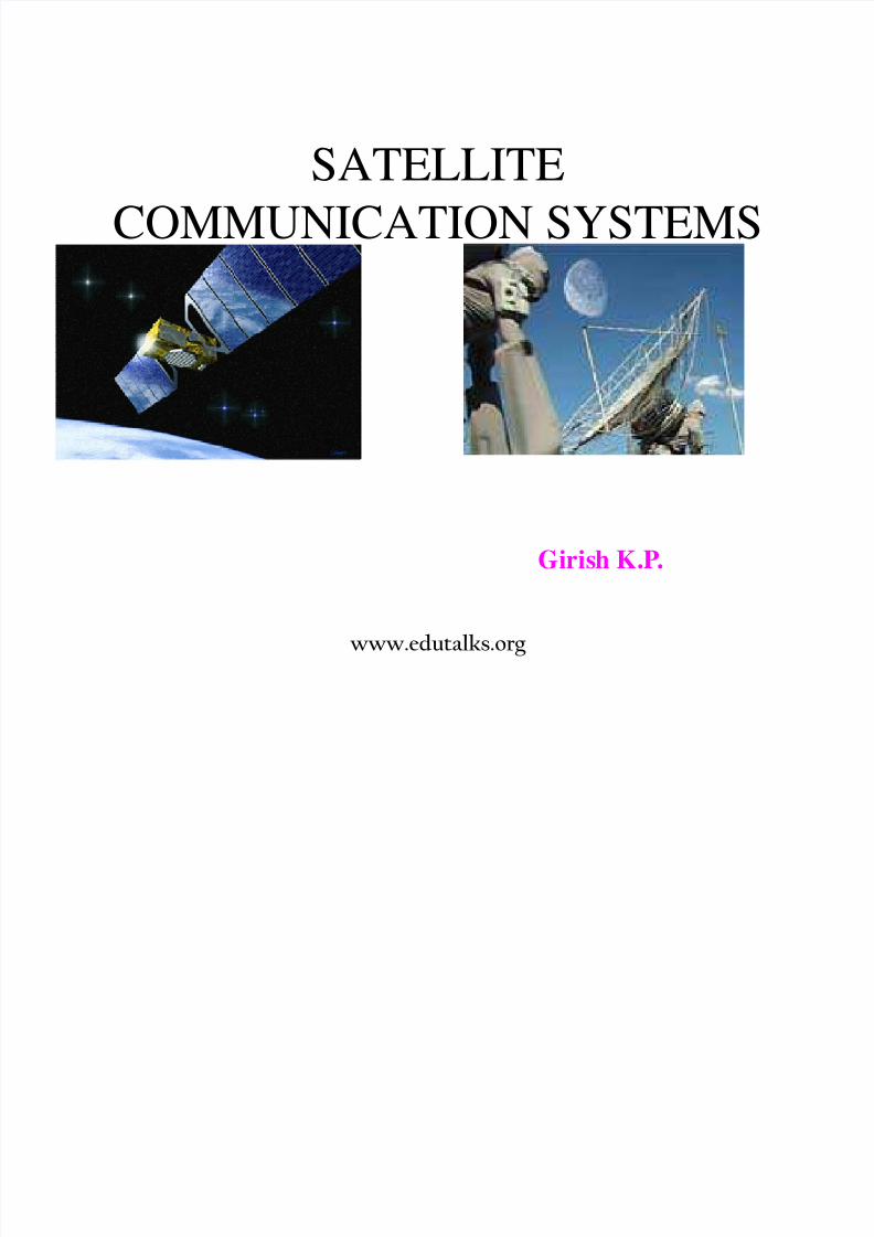
SATELLITE
COMMUNICATION SYSTEMS
Girish K.P.
www.edutalks.org

8/3/2019 Satellite Mod 1
http://slidepdf.com/reader/full/satellite-mod-1 2/165
Communication satellites bring the world
to you anywhere and any time…..
www.edutalks.org

8/3/2019 Satellite Mod 1
http://slidepdf.com/reader/full/satellite-mod-1 3/165
What exactly is a satellite?
• The word satellite originated from the Latin word “Satellit”- meaning
an attendant, one who is constantly hovering around & attending to a
“master” or big man.
• For our own purposes however a satellite is simply any body that
moves aroun ano er usua y muc arger one n a ma ema ca ypredictable path called an orbit.
• A communication satellite is a microwave repeater staion in space that
is used for tele communcation , radio and television signals.
• The first man made satellite with radio transmitter was in 1957.
. There are about 750 satellite in the space, most of them are used forcommunication.
www.edutalks.org

8/3/2019 Satellite Mod 1
http://slidepdf.com/reader/full/satellite-mod-1 4/165
How do satellite work?
www.edutalks.org

8/3/2019 Satellite Mod 1
http://slidepdf.com/reader/full/satellite-mod-1 5/165
How do Satellites Work?
* Two Stations on Earth want to communicate through radio
broadcast but are too far away to use conventional means.
The two stations can use a satellite as a relay station for their
communication.
* One Earth Station transmits the signals to the satellite. Up link
communicating with Satellite.
* The satellite Transponder converts the signal and sends it down
to the second earth station. This frequency is called a Downlink.
www.edutalks.org

8/3/2019 Satellite Mod 1
http://slidepdf.com/reader/full/satellite-mod-1 6/165
Consider the light bulb example:
www.edutalks.org

8/3/2019 Satellite Mod 1
http://slidepdf.com/reader/full/satellite-mod-1 7/165
Components of a satellite
www.edutalks.org

8/3/2019 Satellite Mod 1
http://slidepdf.com/reader/full/satellite-mod-1 8/165
Advantages of satellite over terrestrial communication :
* The coverage area of a satellite greatly exceeds that of a
terrestrial system.
* Transmission cost of a satellite is independent of the distance
from the center of the coverage area.* Satellite to Satellite communication is very precise.
* Higher Bandwidths are available for use.
Disadvantages of satellites:
* Launching satellites into orbit is costly.
* Satellite bandwidth is gradually becoming used up.* There is a larger propagation delay in satellite communication
than in terrestrial communication.

8/3/2019 Satellite Mod 1
http://slidepdf.com/reader/full/satellite-mod-1 9/165
How does a satellite stay in it’s orbit?
www.edutalks.org
8/3/2019 Satellite Mod 1
http://slidepdf.com/reader/full/satellite-mod-1 10/165
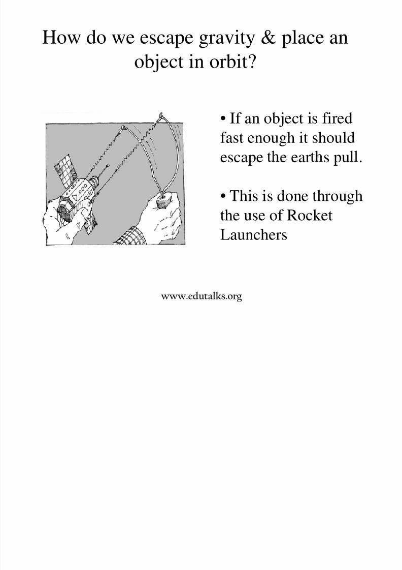
How do we escape gravity & place an
object in orbit?
• If an object is fired
fast enough it should
escape e ear s pu .
• This is done through
the use of RocketLaunchers
www.edutalks.org

8/3/2019 Satellite Mod 1
http://slidepdf.com/reader/full/satellite-mod-1 11/165
Multi-stage Rockets
• Stage 1: Raises the
payload e.g. a satellite toan elevation of about 50miles.
• Sta e 2: Satellite 100
miles and the third stageplaces it into the transferorbit.
• Stage 3: The satellite is
placed in its final geo-synchronous orbital slotby the AKM, a type ofrocket used to move the
satellite.
www.edutalks.org
8/3/2019 Satellite Mod 1
http://slidepdf.com/reader/full/satellite-mod-1 12/165
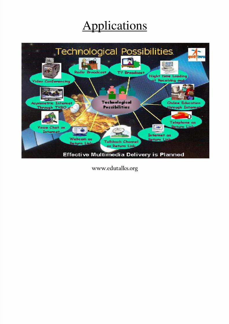
Applications
www.edutalks.org
8/3/2019 Satellite Mod 1
http://slidepdf.com/reader/full/satellite-mod-1 13/165
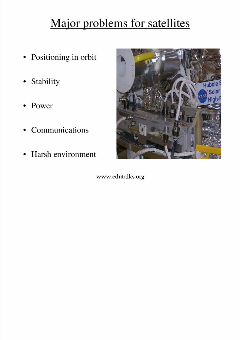
Major problems for satellites
• Positioning in orbit
• Stability
• Power
• Communications
• Harsh environment
www.edutalks.org

8/3/2019 Satellite Mod 1
http://slidepdf.com/reader/full/satellite-mod-1 14/165
Positioning
• This can be achieved by several methods
• One method is to use small rocket motors
• These use fuel - over half of the weight of most satellites is made up of fuel
determines the lifetime of a satellite
• Commercial life of a satellite typically 10-
15 years
www.edutalks.org

8/3/2019 Satellite Mod 1
http://slidepdf.com/reader/full/satellite-mod-1 15/165
Stability
• It is vital that satellites are stabilised
- to ensure that solar panels are aligned properly,
communication antennae are aligned properly
• Early satellites used spin stabilisation
- either this requires an inefficient omni-directional
aerial Or antennae were precisely counter-rotated inorder to provide stable communications.
* Modern satellites use reaction wheel
stabilisation - a form of gyroscopic stabilisation.

8/3/2019 Satellite Mod 1
http://slidepdf.com/reader/full/satellite-mod-1 16/165
Power
• Modern satellites use a variety of power means• Solar panels are now quite efficient, so solar
• Batteries are needed as sometimes the satellites
are behind the earth - this happens about half the
time for a LEO satellite• Nuclear power has been used - but not
recommended
www.edutalks.org

8/3/2019 Satellite Mod 1
http://slidepdf.com/reader/full/satellite-mod-1 17/165
Satellite - satellite communication
• It is also possible forsatellites tocommunicate withother satellites
• Communication canbe by microwave orb o tical laser
1.
2.
1.
2.
1.
2.
Point-Point System Crosslink System Hybrid System
www.edutalks.org
8/3/2019 Satellite Mod 1
http://slidepdf.com/reader/full/satellite-mod-1 18/165
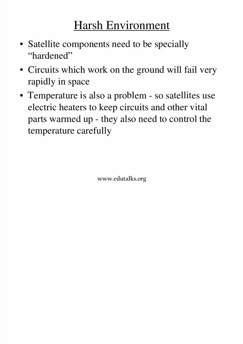
Harsh Environment
• Satellite components need to be specially
“hardened”
• Circuits which work on the ground will fail veryrapidly in space
• empera ure s a so a pro em - so sa e es useelectric heaters to keep circuits and other vital
parts warmed up - they also need to control the
temperature carefully
www.edutalks.org
8/3/2019 Satellite Mod 1
http://slidepdf.com/reader/full/satellite-mod-1 19/165
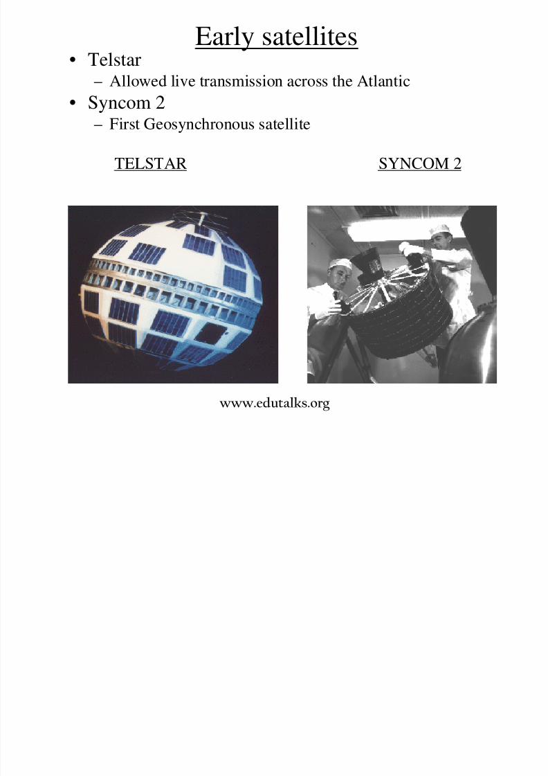
Early satellites• Telstar
– Allowed live transmission across the Atlantic
• Syncom 2– First Geosynchronous satellite
TELSTAR SYNCOM 2
www.edutalks.org

8/3/2019 Satellite Mod 1
http://slidepdf.com/reader/full/satellite-mod-1 20/165
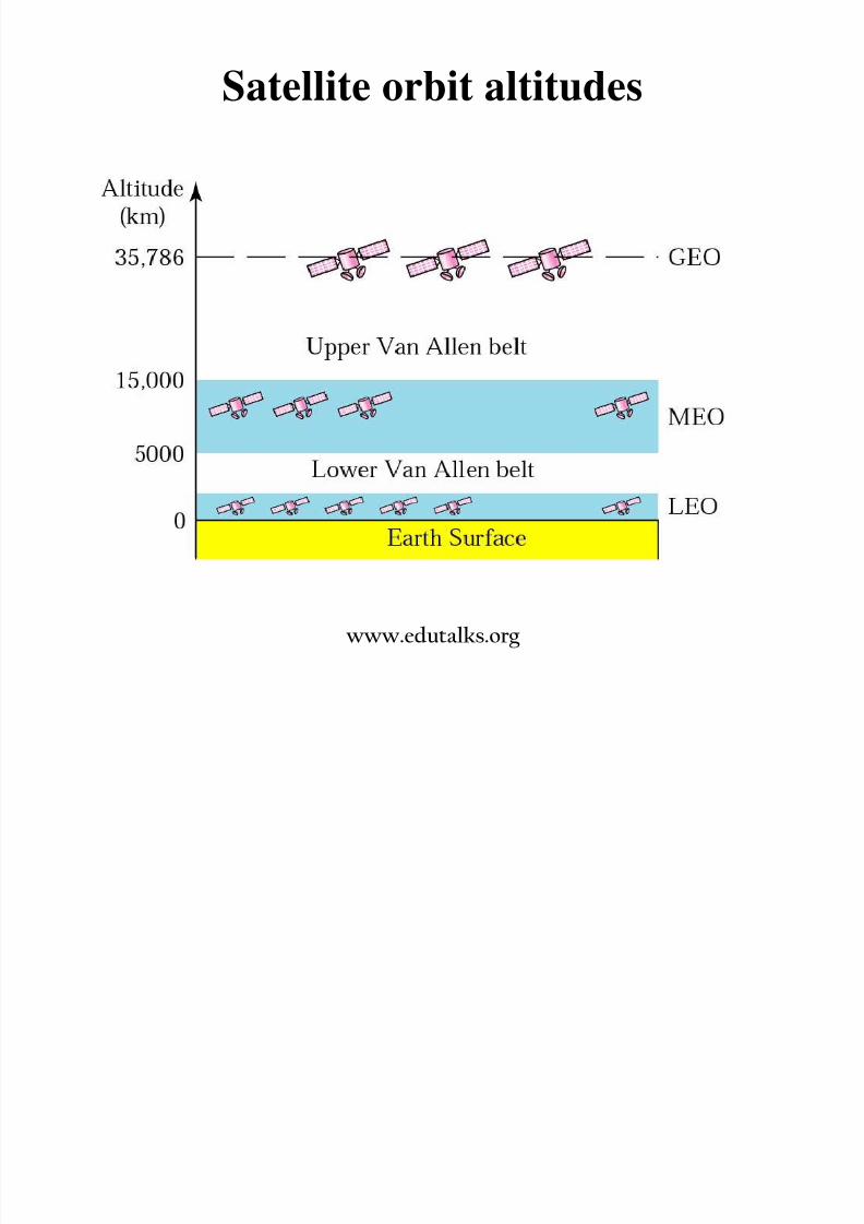
Satellite orbits
Classification of orbits:
www.edutalks.org

8/3/2019 Satellite Mod 1
http://slidepdf.com/reader/full/satellite-mod-1 21/165
* Circular orbits are simplest
* Inclined orbits are useful for coverage of
equatorial regions* Elliptical orbits can be used to give quasi
4 satellites
* Orbit changes can be used to extend the life of
satellites
www.edutalks.org

8/3/2019 Satellite Mod 1
http://slidepdf.com/reader/full/satellite-mod-1 22/165
Classification of orbits:
Satellite orbits are also classified based on theirheights above the earth:
– GEO– LEO
– MEO
– Molniya Orbit– HAPs
www.edutalks.org
8/3/2019 Satellite Mod 1
http://slidepdf.com/reader/full/satellite-mod-1 23/165
Satellite orbit altitudes
www.edutalks.org

8/3/2019 Satellite Mod 1
http://slidepdf.com/reader/full/satellite-mod-1 24/165
Geostationary Earth Orbit (GEO)
• These satellites are in orbit 35,786 km above the earth’ssurface along the equator.
• Objects in Geostationary orbit revolve around the earthat the same speed as the earth rotates. This means GEO
satellites remain in the same position relative to thesurface of earth.
www.edutalks.org

8/3/2019 Satellite Mod 1
http://slidepdf.com/reader/full/satellite-mod-1 25/165
GEO contd.
• Advantages– A GEO satellite’s distance from earth gives it a large
coverage area, almost a fourth of the earth’s surface.
– GEO satellites have a 24 hour view of a particular area.
– These factors make it ideal for satellite broadcast and other
multipoint applications
– Minimal do ler shift
• Disadvantages
– A GEO satellite’s distance also cause it to have both a
comparatively weak signal and a time delay in the signal,
which is bad for point to point communication.– GEO satellites, centered above the equator, have difficulty for
broadcasting signals to near polar regions
– Launching of satellites to orbit are complex and expensive.
www.edutalks.org

8/3/2019 Satellite Mod 1
http://slidepdf.com/reader/full/satellite-mod-1 26/165
Low Earth Orbit (LEO)• LEO satellites are much closer to the earth than GEO satellites,
ranging from 500 to 1,500 km above the surface.
• LEO satellites don’t stay in fixed position relative to the surface,and are only visible for 15 to 20 minutes each pass.
• A network of LEO satellites is necessary for LEO satellites to beuseful

8/3/2019 Satellite Mod 1
http://slidepdf.com/reader/full/satellite-mod-1 27/165
The Iridium system has 66 satellites in six LEO orbits,
each at an altitude of 750 km.
Iridium is designed to provide direct worldwide voice and data
communication using handheld terminals, a service similar to
cellular telephony but on a global scale
www.edutalks.org
8/3/2019 Satellite Mod 1
http://slidepdf.com/reader/full/satellite-mod-1 28/165
LEO Contd.
• Advantages
A LEO satellite’s proximity to earth compared to a GEO
satellite gives it a better signal strength and less of a time
delay, which makes it better for point to pointcommunication.
A LEO satellite’s smaller area of coverage is less of a waste
of bandwidth.
• Disadvantages
A network of LEO satellites is needed, which can be costly
LEO satellites have to compensate for Doppler shifts cause bytheir relative movement.
Atmospheric drag effects LEO satellites, causing gradual
orbital deterioration.
www.edutalks.org

8/3/2019 Satellite Mod 1
http://slidepdf.com/reader/full/satellite-mod-1 29/165
Medium Earth Orbit (MEO)
• A MEO satellite is in orbit somewhere between 8,000km and 18,000 km above the earth’s surface.
• MEO satellites are similar to LEO satellites in
functionality.• MEO satellites are visible for much longer periods of
time than LEO satellites, usually between 2 to 8 hours.
• MEO satellites have a larger coverage area than LEOsatellites.
www.edutalks.org
8/3/2019 Satellite Mod 1
http://slidepdf.com/reader/full/satellite-mod-1 30/165
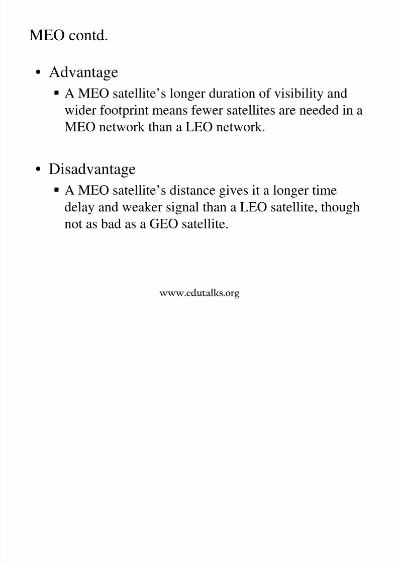
MEO contd.
• Advantage
A MEO satellite’s longer duration of visibility and
wider footprint means fewer satellites are needed in aMEO network than a LEO network.
• Disadvantage
A MEO satellite’s distance gives it a longer time
delay and weaker signal than a LEO satellite, though
not as bad as a GEO satellite.
www.edutalks.org
8/3/2019 Satellite Mod 1
http://slidepdf.com/reader/full/satellite-mod-1 31/165
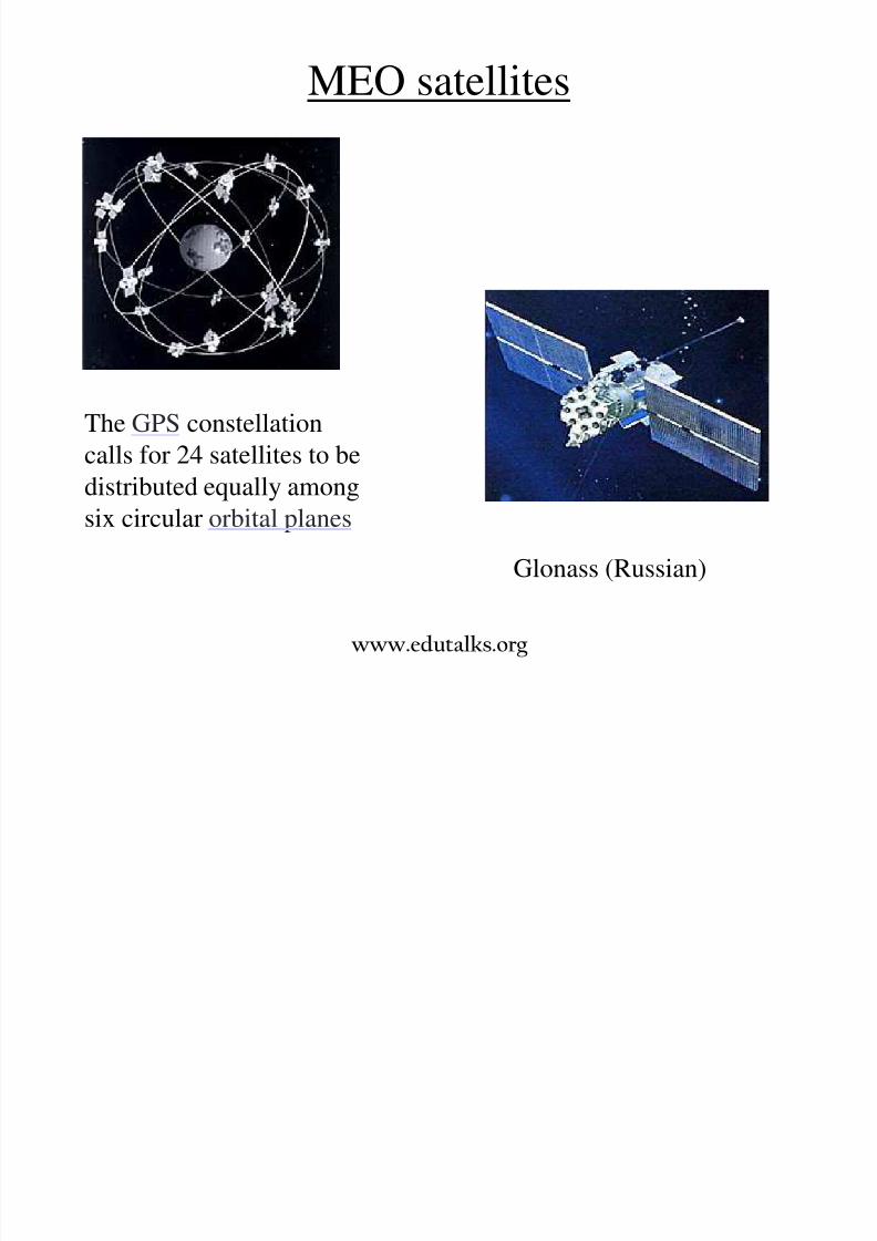
MEO satellites
Glonass (Russian)
The GPS constellation
calls for 24 satellites to be
distributed equally amongsix circular orbital planes
www.edutalks.org

8/3/2019 Satellite Mod 1
http://slidepdf.com/reader/full/satellite-mod-1 32/165
Molniya Orbit
Used by Russia for decades.
Molniya Orbit is an elliptical orbit. The satellite remains in a
nearly fixed position relative to earth for eight hours.
A series of three Molniya satellites can act like a GEO satellite. Useful in near polar regions.
www.edutalks.org
8/3/2019 Satellite Mod 1
http://slidepdf.com/reader/full/satellite-mod-1 33/165
High Altitude Platform (HAP)
One of the newest ideas in satellite communication. A blimp or plane around 20 km above the earth’s surface is
used as a satellite.
HAPs would have very small coverage area, but would have acomparatively strong signal.
Cheaper to put in position, but would require a lot of them in anetwork.
www.edutalks.org

8/3/2019 Satellite Mod 1
http://slidepdf.com/reader/full/satellite-mod-1 34/165
HAP
www.edutalks.org
8/3/2019 Satellite Mod 1
http://slidepdf.com/reader/full/satellite-mod-1 35/165
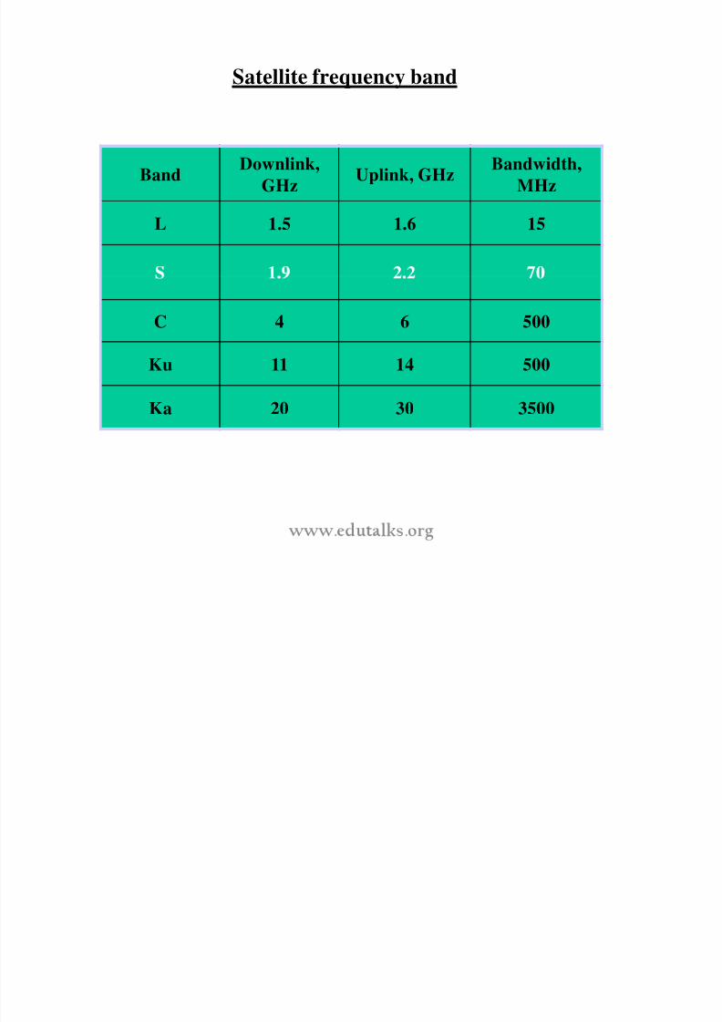
Satellite frequency band
BandDownlink,
GHzUplink, GHz
Bandwidth,
MHz
L 1.5 1.6 15
C 4 6 500
Ku 11 14 500
Ka 20 30 3500
8/3/2019 Satellite Mod 1
http://slidepdf.com/reader/full/satellite-mod-1 36/165
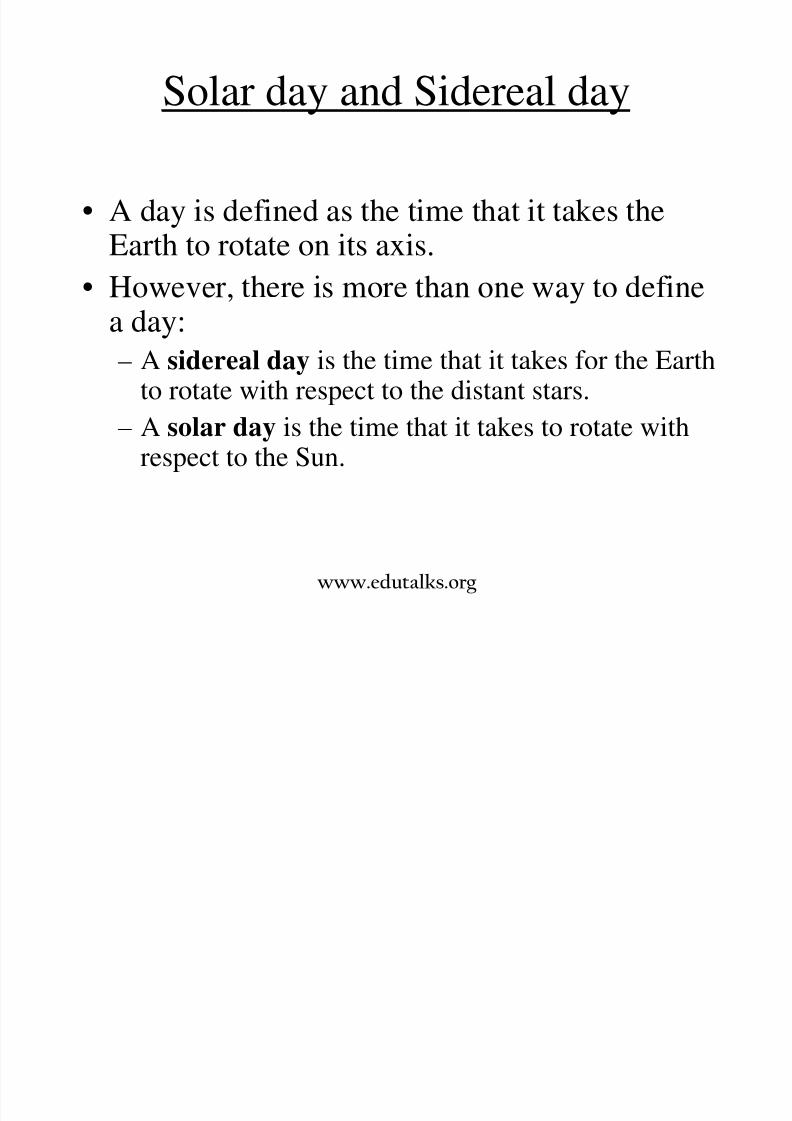
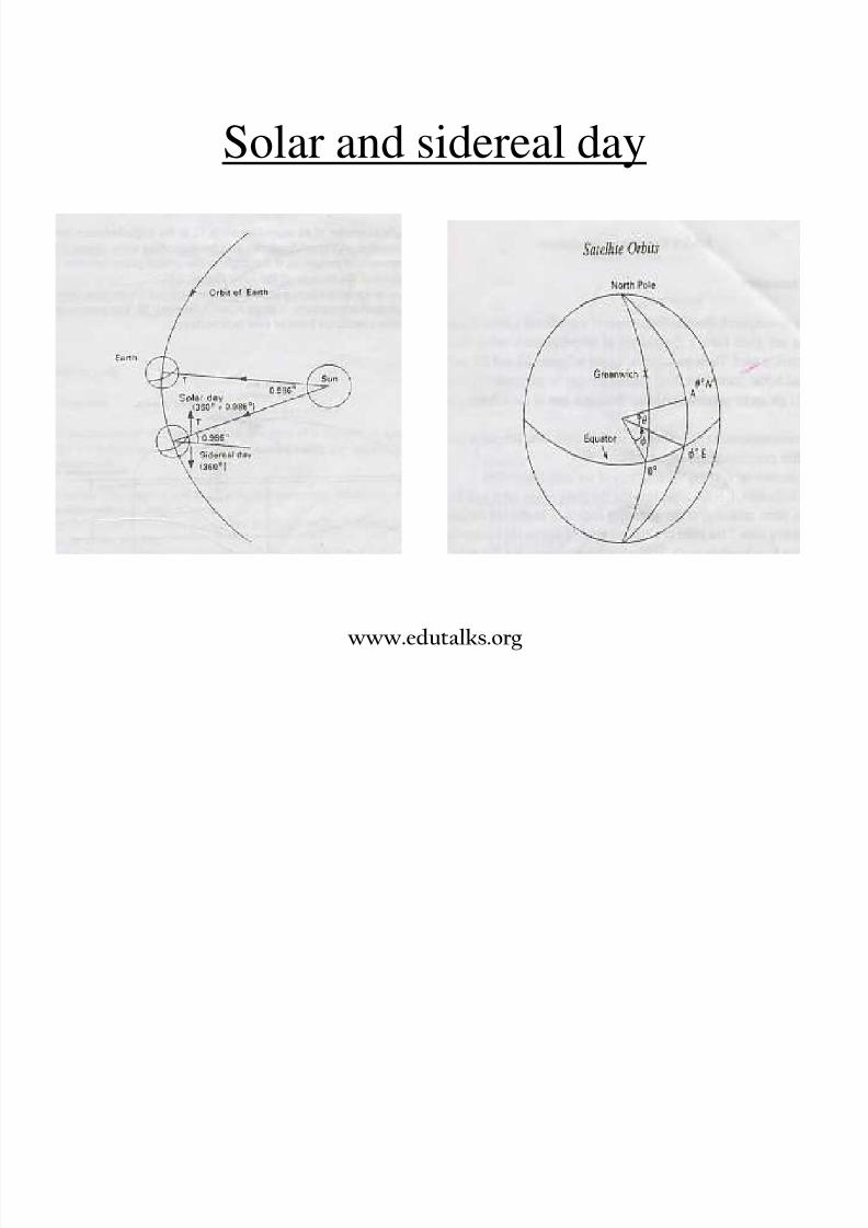
Solar day and Sidereal day
• A day is defined as the time that it takes theEarth to rotate on its axis.
• However, there is more than one way to define
a day:– A sidereal day is the time that it takes for the Earth
to rotate with respect to the distant stars.
– A solar day is the time that it takes to rotate withrespect to the Sun.
www.edutalks.org

8/3/2019 Satellite Mod 1
http://slidepdf.com/reader/full/satellite-mod-1 37/165
The Length of the Day
• A solar day is slightly longer than a sidereal day.
– A sidereal day is 23h 56m 4.091s.
• We set our watches according to the solar day.
• s ronomers use s erea me ecause we are
mostly interested in distant celestial objects.
www.edutalks.org

8/3/2019 Satellite Mod 1
http://slidepdf.com/reader/full/satellite-mod-1 38/165
Solar day and Sidereal day
• A solar day is measured using the passage of theSun across the sky—it lasts 24 hours
• A sidereal day (from the Latin word meaningstar) is measured with respect to fixed stars—itlasts a little less than 24 hours.
• Eac so ar ay t e Eart rotates egrees w trespect to the Sun
• Each sidereal day the Earth rotates 360 degrees
with respect to the background stars• During each solar day the motion of the Earth
around the Sun means the Earth rotates 361
degrees with respect to the background starswww.edutalks.org

8/3/2019 Satellite Mod 1
http://slidepdf.com/reader/full/satellite-mod-1 39/165
• The actual length of a sidereal day on Earth is 23 hours 56minutes 4 seconds
• This means that the Earth has to rotate slightly more than oneturn with respect to a fixed star to reach the same Earth-Sunorientation (solar day)
www.edutalks.org
8/3/2019 Satellite Mod 1
http://slidepdf.com/reader/full/satellite-mod-1 40/165
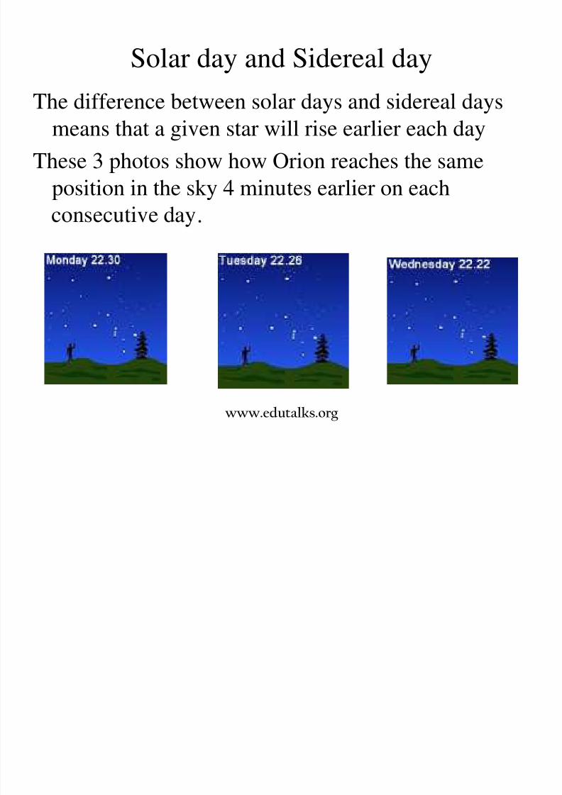
Solar day and Sidereal day
The difference between solar days and sidereal days
means that a given star will rise earlier each day
These 3 photos show how Orion reaches the sameposition in the sky 4 minutes earlier on each
.
www.edutalks.org
8/3/2019 Satellite Mod 1
http://slidepdf.com/reader/full/satellite-mod-1 41/165
Apparent Solar Time
• Apparent solar time is the time measured withrespect to the actual position of the Sun.
– At noon, the Sun would be exactly on the meridian.
– . .
the meridian.– 9 A.M. would be exactly 3 hours before the Sun was on
the meridian.
– The apparent solar time depends on your longitude.
www.edutalks.org
O i i f l t l
8/3/2019 Satellite Mod 1
http://slidepdf.com/reader/full/satellite-mod-1 42/165
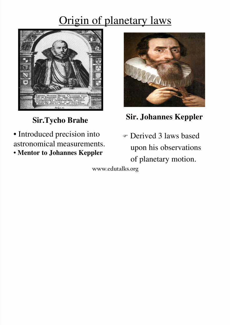
Origin of planetary laws
Sir. Johannes Keppler
Derived 3 laws based
upon his observations
of planetary motion.
Sir.Tycho Brahe
• Introduced precision into
astronomical measurements.• Mentor to Johannes Keppler
www.edutalks.org

8/3/2019 Satellite Mod 1
http://slidepdf.com/reader/full/satellite-mod-1 43/165
Kepler’s 1st Law: Law of Ellipses
The orbits of the planets are ellipses with
the sun at one focuswww.edutalks.org
’ f A

8/3/2019 Satellite Mod 1
http://slidepdf.com/reader/full/satellite-mod-1 44/165
Kepler’s 2nd Law: Law of Equal Areas
The line joining the planet to the center of the sun
sweeps out equal areas in equal times
T5T4 T3
T6
T1A2A3A4A5
A6
A1
www.edutalks.org
8/3/2019 Satellite Mod 1
http://slidepdf.com/reader/full/satellite-mod-1 45/165
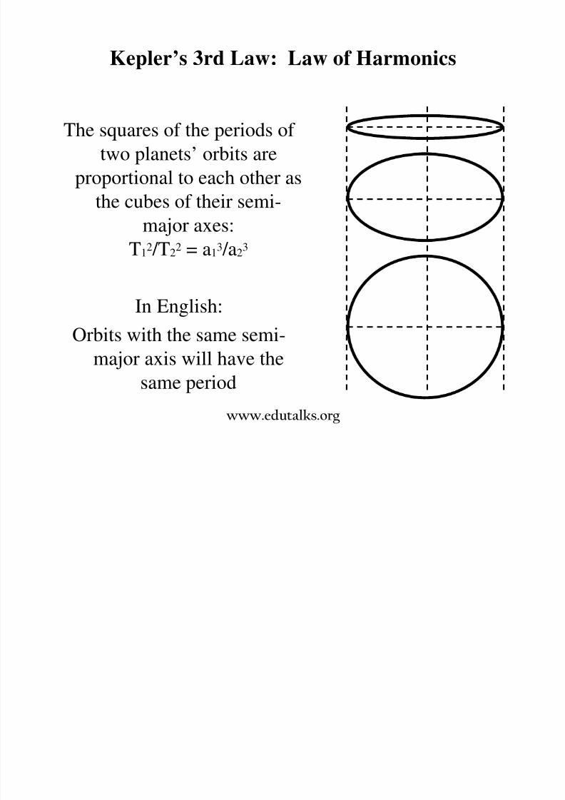
Kepler’s 3rd Law: Law of Harmonics
The squares of the periods of
two planets’ orbits areproportional to each other as
the cubes of their semi-
major axes:
T12 /T2
2 = a13 /a2
3
In English:Orbits with the same semi-
major axis will have the
same periodwww.edutalks.org
Newton’s Laws

8/3/2019 Satellite Mod 1
http://slidepdf.com/reader/full/satellite-mod-1 46/165
Newton s Laws
• Kepler’s laws only describe the planetary motionwithout attempting to suggest any explanation as
to why the motion takes place in that manner.
Sir .Issac Newton
.
• Derived the Law of Universal
Gravitation.
• Explained why Kepler’s laws
worked.
www.edutalks.org

8/3/2019 Satellite Mod 1
http://slidepdf.com/reader/full/satellite-mod-1 47/165
Newton’s 1st Law: Law of Inertia
• Every body continues in a state of uniformmotion unless it is compelled to change that
state b a force im osed u on it
www.edutalks.org
8/3/2019 Satellite Mod 1
http://slidepdf.com/reader/full/satellite-mod-1 48/165
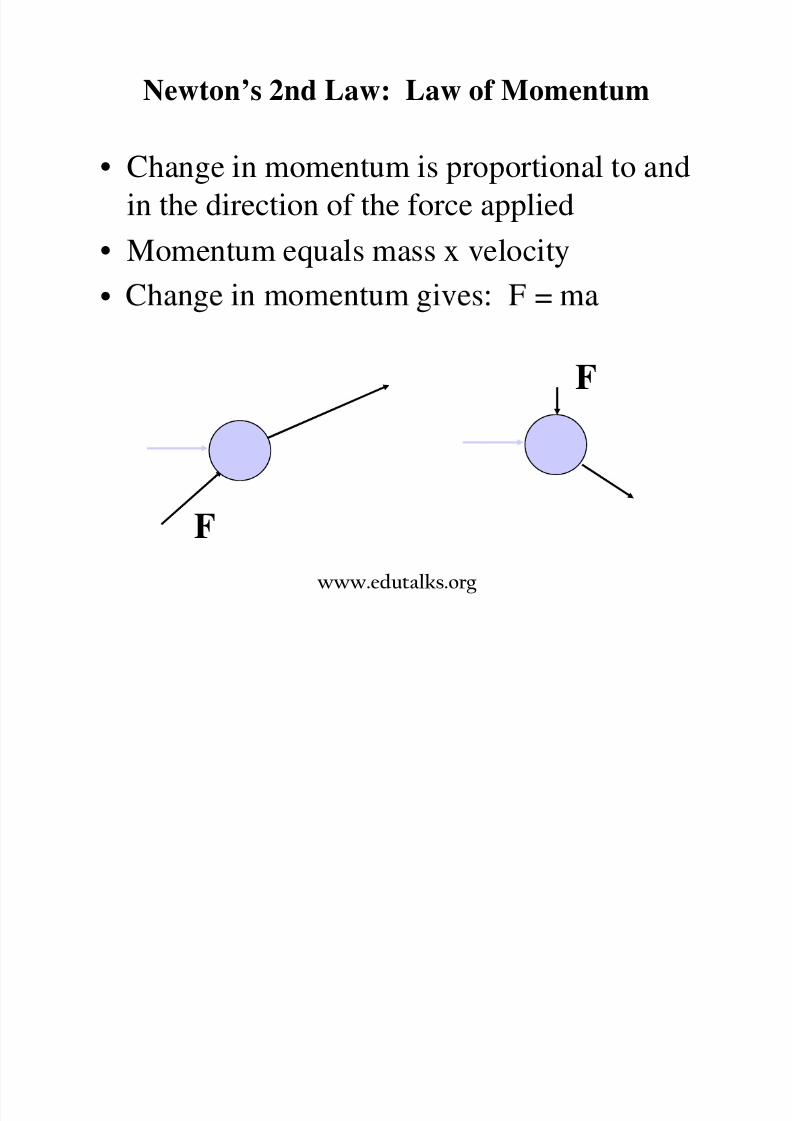
Newton’s 2nd Law: Law of Momentum
• Change in momentum is proportional to and
in the direction of the force applied
• Momentum equals mass x velocity
• =
F
F
www.edutalks.org

8/3/2019 Satellite Mod 1
http://slidepdf.com/reader/full/satellite-mod-1 49/165
Newton’s 3rd Law: Action - Reaction
• For every action, there is an equal andopposite reaction
•
www.edutalks.org
8/3/2019 Satellite Mod 1
http://slidepdf.com/reader/full/satellite-mod-1 50/165
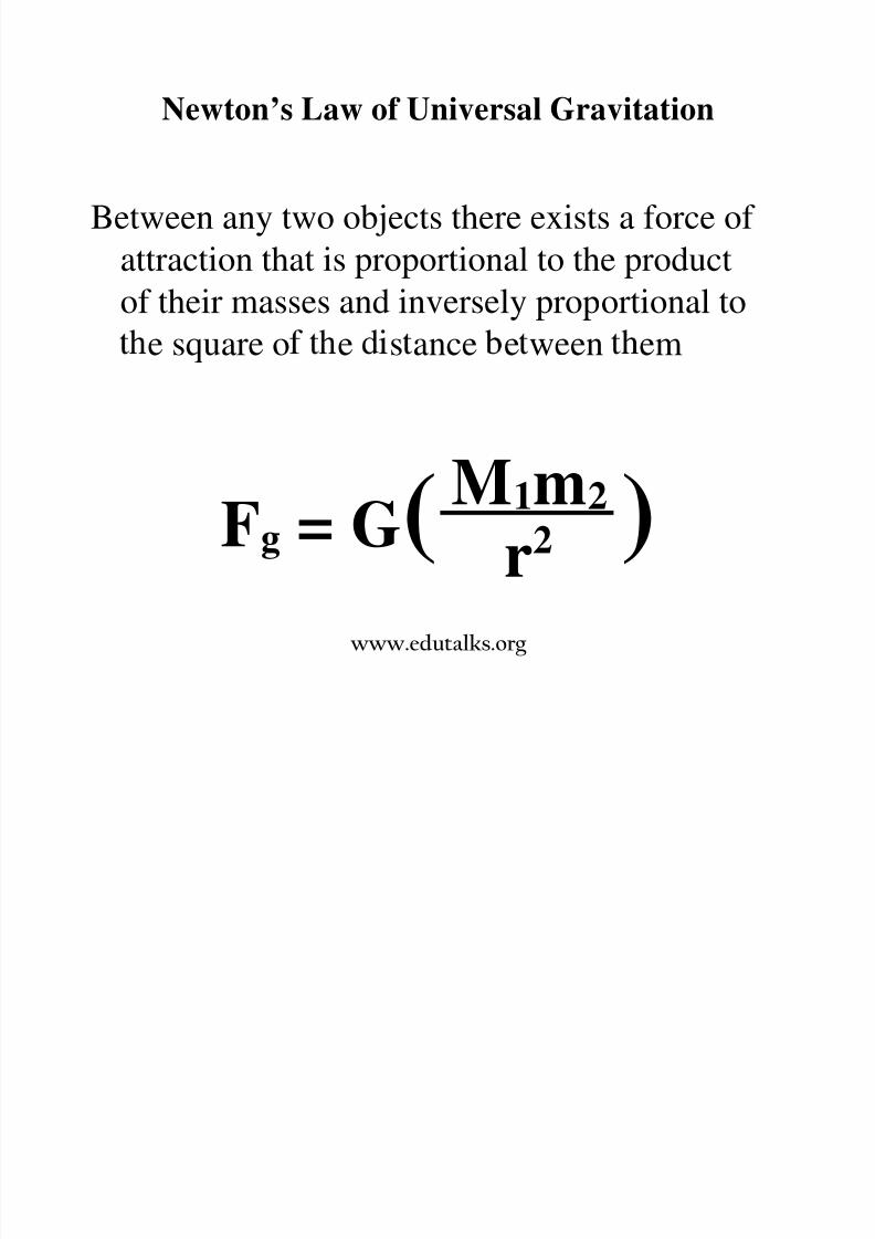
Newton’s Law of Universal Gravitation
Between any two objects there exists a force of
attraction that is proportional to the productof their masses and inversely proportional to
e square o e s ance e ween em
Fg = G( )M1m2
r2
www.edutalks.org
8/3/2019 Satellite Mod 1
http://slidepdf.com/reader/full/satellite-mod-1 51/165
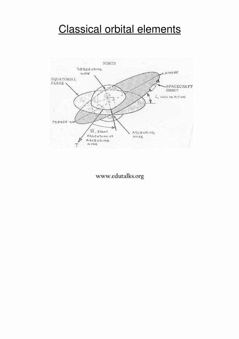
Classical orbital elements
www.edutalks.org
Apogee and Perigee

8/3/2019 Satellite Mod 1
http://slidepdf.com/reader/full/satellite-mod-1 52/165
p g g
• In astronomy, an apsis is the point of greatest or least distanceof the elliptical orbit of an astronomical object from its center of attraction, which is generally the center of mass of the system.
• The point of closest approach is called the periapsis (Perigee)or pericentre and the point of farthest excursion is called theapoapsis (apogee)
• A straight line drawn through the perigee and apogee is the line
of apsides. This is the major axis of the ellipse.
Ascending & Descending nodes
• These are the 2 points at which the orbit of a satellite penetrates
the equatorial plane.
www.edutalks.org
Cl i l bi l l
8/3/2019 Satellite Mod 1
http://slidepdf.com/reader/full/satellite-mod-1 53/165
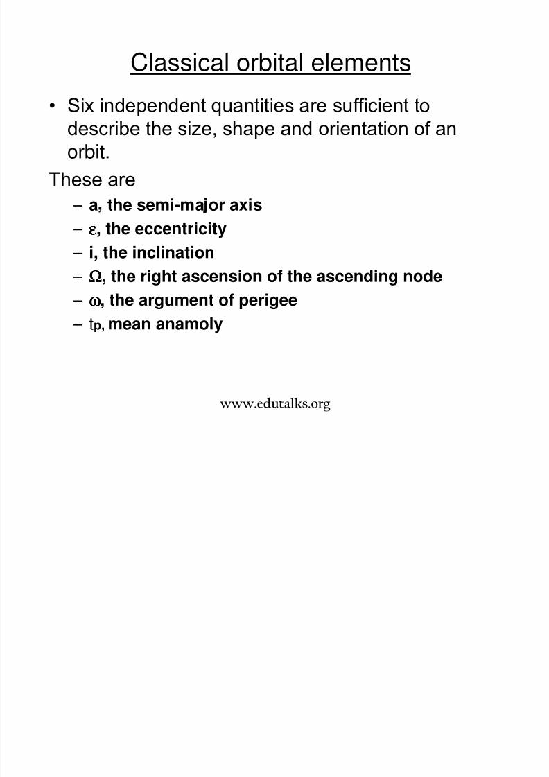
Classical orbital elements
• Six independent quantities are sufficient to
describe the size, shape and orientation of an
orbit.These are
– a the semi-ma or axis
– εεεε, the eccentricity – i, the inclination
– ΩΩΩΩ, the right ascension of the ascending node
– ωωωω, the argument of perigee – tp, mean anamoly
www.edutalks.org
• The semi-major axis describes the size of the orbit. It

8/3/2019 Satellite Mod 1
http://slidepdf.com/reader/full/satellite-mod-1 54/165
The semi major axis describes the size of the orbit. Itconnects the geometric center of the orbital ellipse withthe periapsis, passing through the focal point where thecenter of mass resides.
• The eccentricity shows the ellipticity of the orbit.
• The inclination is the angle between the plane of theorbit and the equatorial plane measured at the ascendingnode in the north ard direction
• The right ascension of an ascending node is the anglebetween the x axis and the ascending node.
• The argument of periapsis (perihelion) is the angle in the
orbital plane between the line of nodes and the perigee of the orbit.
• The mean anomaly is the time elapsed since the satellitepassed the perigee.
www.edutalks.org
Major parameters of an elliptical orbit

8/3/2019 Satellite Mod 1
http://slidepdf.com/reader/full/satellite-mod-1 55/165
Major parameters of an elliptical orbit
• Satellite trajectory
• Satellite period
• Satellite velocity
• Satellite position
Satellite Trajectory

8/3/2019 Satellite Mod 1
http://slidepdf.com/reader/full/satellite-mod-1 56/165
j y
The path of a satellite in space may be obtainedunder the following assumptions:
1.The satellite and earth are symmetric spherically
and may be treated as point masses.
2.There are no other forces acting on the system
besides the gravitational forces.3.The mass of the earth is much greater than
satellite.
These assumptions lead to the two body problem.
www.edutalks.org
Applying Newton's laws to such systems,
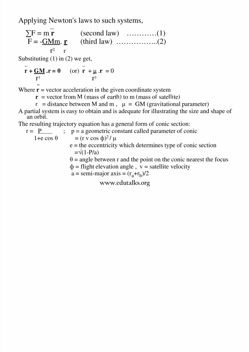
8/3/2019 Satellite Mod 1
http://slidepdf.com/reader/full/satellite-mod-1 57/165
..∑F = m r (second law) …………(1)F = -GMm. r (third law) ……………..(2)
r2 r
Substituting (1) in (2) we get,.. ..
r + GM .r = 0 (or) r + µ .r = 0r3 r3
..
Where r = vector acceleration in the given coordinate system
r = vector rom mass o eart to m mass o sate te
r = distance between M and m , µ = GM (gravitational parameter)A partial system is easy to obtain and is adequate for illustrating the size and shape of
an orbit.
The resulting trajectory equation has a general form of conic section:
r = P ; p = a geometric constant called parameter of conic
1+e cos θ = (r v cos ф)2 / µe = the eccentricity which determines type of conic section
=√(1-P/a)
θ = angle between r and the point on the conic nearest the focus
ф = flight elevation angle , v = satellite velocity
a = semi-major axis = (ra+rb)/2
www.edutalks.org
Satellite period
8/3/2019 Satellite Mod 1
http://slidepdf.com/reader/full/satellite-mod-1 58/165
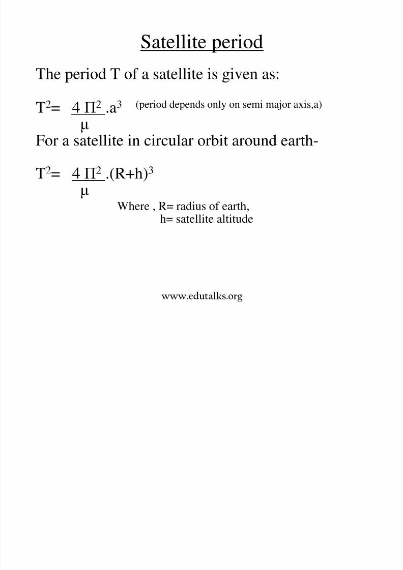
Satellite period
The period T of a satellite is given as:
T2= 4 П2 .a3 (period depends only on semi major axis,a)
µFor a satellite in circular orbit around earth-
T2= 4 П2 .(R+h)3
µWhere , R= radius of earth,
h= satellite altitude
www.edutalks.org
Satellite velocity

8/3/2019 Satellite Mod 1
http://slidepdf.com/reader/full/satellite-mod-1 59/165
Total specific mechanical energy ε of a satellite is the sumof kinetic energy/unit mass and potential energy/unit
mass, but there is an interchange between these energies.
Thus a satellite slows down when it moves up and gainsspeed as it loses height.
V2= µ(2/r -1/a)
also ε = V2 / 2 - µ /r and ε = –µ /2a
For circular orbit the equation reduces to:
V2 = µ /r
www.edutalks.org
Satellite position with time

8/3/2019 Satellite Mod 1
http://slidepdf.com/reader/full/satellite-mod-1 60/165
The origin O is the geocentre.
The satellite at any instant tp is assumed to be at S.
The circle is drawn from centre C of the ellipse with a radius equal to
the semi major axis and a perpendicular BM is drawn passing throughthe point S.
Angle E is called eccentric anomaly and angle θ is the true anomaly.
www.edutalks.org
Satellite position
8/3/2019 Satellite Mod 1
http://slidepdf.com/reader/full/satellite-mod-1 61/165
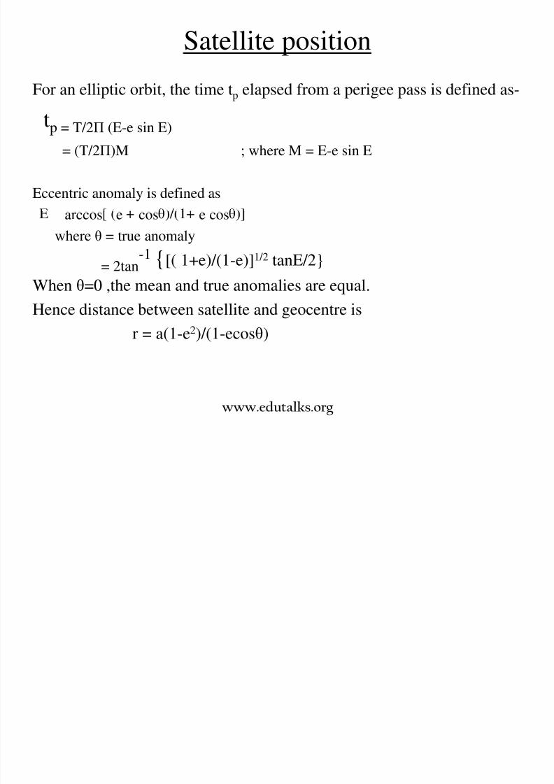
For an elliptic orbit, the time tp elapsed from a perigee pass is defined as-
tp = T/2Π (E-e sin E)
= (T/2Π)M ; where M = E-e sin E
Eccentric anomaly is defined as
= arccos e cos e cos
where θ = true anomaly
= 2tan-1 [( 1+e)/(1-e)]1/2 tanE/2
When θ=0 ,the mean and true anomalies are equal.
Hence distance between satellite and geocentre isr = a(1-e2)/(1-ecosθ)
www.edutalks.org

8/3/2019 Satellite Mod 1
http://slidepdf.com/reader/full/satellite-mod-1 62/165
GEOSYNCHRONOUS
AND
GEOSTATIONARY ORBITS
www.edutalks.org
GEOSYNCHRONOUS ORBITS
8/3/2019 Satellite Mod 1
http://slidepdf.com/reader/full/satellite-mod-1 63/165
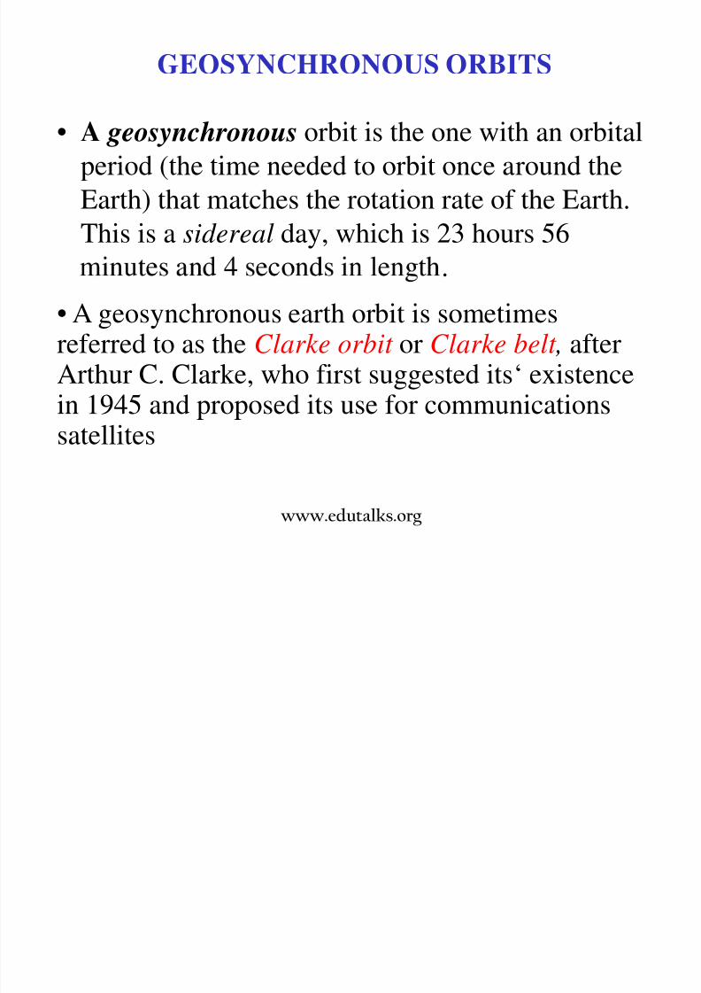
• A geosynchronous orbit is the one with an orbital
period (the time needed to orbit once around the
Earth) that matches the rotation rate of the Earth.This is a sidereal day, which is 23 hours 56
.
• A geosynchronous earth orbit is sometimesreferred to as the Clarke orbit or Clarke belt , afterArthur C. Clarke, who first suggested its‘ existencein 1945 and proposed its use for communicationssatellites
www.edutalks.org
Clarke Orbit

8/3/2019 Satellite Mod 1
http://slidepdf.com/reader/full/satellite-mod-1 64/165
• The Clarke orbit meets the
concise set of specifications
for geosynchronous satellite
orbits:– (1) be located directly above
– (2) travel in the samedirection as Earth's rotation at
6840 mph
– (3) have an altitude of 22,300
miles above Earth
– (4) complete one revolution in
24 hours
www.edutalks.org
Clarke Orbit

8/3/2019 Satellite Mod 1
http://slidepdf.com/reader/full/satellite-mod-1 65/165
www.edutalks.org
Geo synchronous Satellites

8/3/2019 Satellite Mod 1
http://slidepdf.com/reader/full/satellite-mod-1 66/165
• There is only one geosynchronous earth orbit.
• It is occupied by a large number of satellites. In fact, the
geosynchronous orbit is the most widely used earth orbit for theobvious reason.
• An international agreement initially mandated that all satellitesp ace n e ar e or mus e separa e y a eas m es.
• This stipulation equates to an angular separation of 4° or more,which limits the number of satellite vehicles in a geosynchronousearth orbit to less than 100.
• Today, however, international agreements allow satellites to beplaced much closer together.
www.edutalks.org
Geo stationary orbit
8/3/2019 Satellite Mod 1
http://slidepdf.com/reader/full/satellite-mod-1 67/165
y
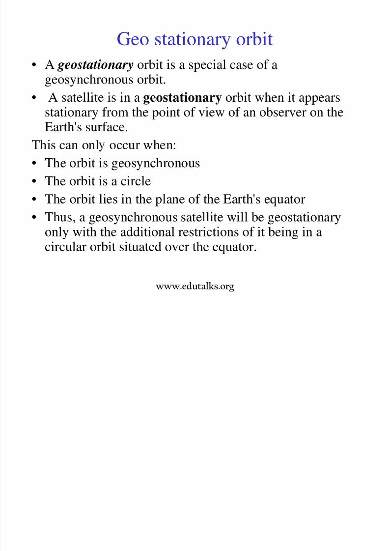
• A geostationary orbit is a special case of ageosynchronous orbit.
• A satellite is in a geostationary orbit when it appears
stationary from the point of view of an observer on theEarth's surface.
This can onl occur when:
• The orbit is geosynchronous• The orbit is a circle
• The orbit lies in the plane of the Earth's equator
• Thus, a geosynchronous satellite will be geostationaryonly with the additional restrictions of it being in acircular orbit situated over the equator.
www.edutalks.org
Geostationary Vs. Polar

8/3/2019 Satellite Mod 1
http://slidepdf.com/reader/full/satellite-mod-1 68/165
y
Orbiting
http://cimss.ssec.wisc.edu/satmet/modules/sat_basics/images/orbits.jpg
www.edutalks.org
Geostationary Satellites

8/3/2019 Satellite Mod 1
http://slidepdf.com/reader/full/satellite-mod-1 69/165
The satellite velocity in this
orbit is 3075 m/s.
• Operate in the 2.0 GHz to18 GHz range
eccentricity of the orbit iszero, the satellite appears to
be stationary to an observer
from ground.
www.edutalks.org
Geostationary Satellites in Orbit
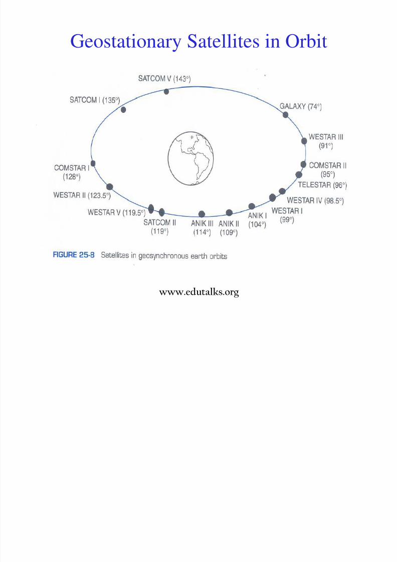
8/3/2019 Satellite Mod 1
http://slidepdf.com/reader/full/satellite-mod-1 70/165
www.edutalks.org

8/3/2019 Satellite Mod 1
http://slidepdf.com/reader/full/satellite-mod-1 71/165
www.edutalks.org

8/3/2019 Satellite Mod 1
http://slidepdf.com/reader/full/satellite-mod-1 72/165
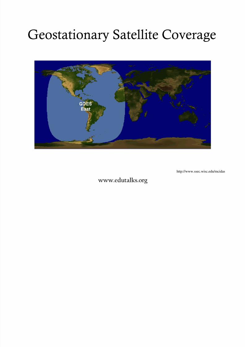
Geostationary Satellite Coverage
http://www.ssec.wisc.edu/mcidas
www.edutalks.org
8/3/2019 Satellite Mod 1
http://slidepdf.com/reader/full/satellite-mod-1 73/165
Geostationary Satellite Coverage
http://www.ssec.wisc.edu/mcidas
www.edutalks.org

8/3/2019 Satellite Mod 1
http://slidepdf.com/reader/full/satellite-mod-1 74/165
Geostationary Satellite Coverage
http://www.ssec.wisc.edu/mcidas
www.edutalks.org
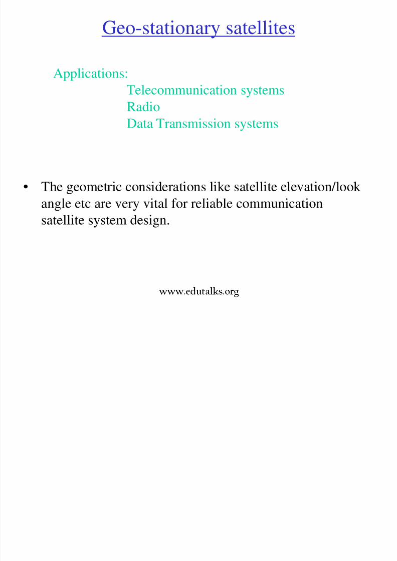
Geo-stationary satellites
8/3/2019 Satellite Mod 1
http://slidepdf.com/reader/full/satellite-mod-1 75/165
Applications:
Telecommunication systems
Radio
Data Transmission systems
• The geometric considerations like satellite elevation/look
angle etc are very vital for reliable communication
satellite system design.
www.edutalks.org
Satellite elevation:

8/3/2019 Satellite Mod 1
http://slidepdf.com/reader/full/satellite-mod-1 76/165
The elevation of a satellite,η is the angle which a satellite makes with
the tangent at the specified point on the earth.
η = arc tan [(cosψ-σ)/ sin ψ]
Where, coverage angle ψ = arc cos (cosθc cosφcs )φcs = φc - φs and σ =R /(R+h) = 0.151
In terms of elevation angle:
ψ = 900 – η-sin-1(cos η / 6.63235)
In terms of tilt angle : ψ = sin -1(6.6235 sinγ- γ) where θc = latitude
of earth station, φc = the longitude, φs = longitude of sub satellite
point, R=radius of earth, h=satellite height above equator
Tilt angle γ = arc tan [sin ψ / (6.6235-cos ψ)www.edutalks.org
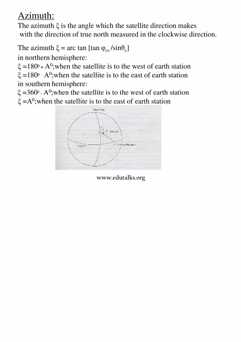
Azimuth:The azimuth ξ is the angle which the satellite direction makes
with the direction of true north measured in the clockwise direction
8/3/2019 Satellite Mod 1
http://slidepdf.com/reader/full/satellite-mod-1 77/165
with the direction of true north measured in the clockwise direction.
The azimuth ξ = arc tan [tan φcs /sinθc]
in northern hemisphere:
ξ =1800 + A0;when the satellite is to the west of earth station
ξ =1800 - A0;when the satellite is to the east of earth station
in southern hemisphere:0 -
ξ =A0
;when the satellite is to the east of earth station
www.edutalks.org
Range:The range d of a geostationary satellite is given by,
1/2

8/3/2019 Satellite Mod 1
http://slidepdf.com/reader/full/satellite-mod-1 78/165
d = 35786[1+0.41991-cos ψ1/2
In terms of radius of earth (ie, der = d/r)
der= [13.47(1-cosβ+31.624)1/2 also der = 6 .6235 sinψ /cos η
• The angle β, is the angle between the solar vector and the orbit
plane. If the solar vector is in the orbit plane, β = 0°. Beta can go
to ± 90°. The general convention is that β is positive when the sun
is on the same side of the orbit plane as the positive orbit normal(right hand rule).
www.edutalks.org
Launching of geostationary satellite:• Initially place spacecraft with the final rocket

8/3/2019 Satellite Mod 1
http://slidepdf.com/reader/full/satellite-mod-1 79/165
stage into LEO.• After a couple of orbits, during which the orbital
parameters are measured, the final stage is
reignited and the spacecraft is launched into a
geostationary transfer orbit(GTO).
• Perigee of GTO is that of LEO altitude and
.
• After a few orbits in GTO, while the orbitalparameters are measured, a rocket motor (AKM)
is ignited at apogee and GTO is raised until it is
circular geostationary orbit.
• AKM (Apogee Kick Motor) is used to circularizethe orbit at GEO and to remove any inclination
error so that the final orbit is very close to
geostationary.
Launching of geostationary satellite

8/3/2019 Satellite Mod 1
http://slidepdf.com/reader/full/satellite-mod-1 80/165
www.edutalks.org
Geostationary Transfer
Orbit

8/3/2019 Satellite Mod 1
http://slidepdf.com/reader/full/satellite-mod-1 81/165
• If we speed the satellite up while it's in low
circular earth orbit it will
go into elliptical orbit,
heading up to apogee.
• If we do nothin else, it
• BUT, if we fire a rocket motor when the satellite's at apogee,
and speed it up to the required circular orbit speed, it will stay at
that altitude in circular orbit. Firing a rocket motor at apogee is
called "apogee kick", and the motor is called the "apogee kick
motor".
will stay in this elliptical
orbit, going from apogee
to perigee and back again.
Few Geostationary satellites: EDUSAT, INTELSAT ,

8/3/2019 Satellite Mod 1
http://slidepdf.com/reader/full/satellite-mod-1 82/165
Phase I and II of launching spacecraft
INSAT , PAKSAT, AMERICOM …….
Phase I ↑
www.edutalks.org
ORBITAL MANEUVERS
Hohmann Transfer

8/3/2019 Satellite Mod 1
http://slidepdf.com/reader/full/satellite-mod-1 83/165
– Can be used to raise or loweraltitude
– Most efficient method
– At minimum, requirescompletion of half revolutionof transfer orbit
www.edutalks.org
Hohmann transfer• Most satellites launched today are initially placed into an
8/3/2019 Satellite Mod 1
http://slidepdf.com/reader/full/satellite-mod-1 84/165
low earth orbit.
In the next phase the satellite is injected into an elliptical
transfer orbit which has an apogee at the height of GEO and
its apsides (line joining perigee-apogee) in the equatorialplane.
velocity increment at the apogee equal to the differencebetween satellite velocity at GTO and velocity in GEO.
• A transfer between two coplanar circular orbits via
elliptical transfer orbit requires the least velocity increment(and hence fuel). This principle was recognized by Hohmann
in 1925 and is referred as Hohmann transfer.
www.edutalks.org
• A Hohmann transfer is a fuel efficient way to transferfrom one circular orbit to another circular orbit that is in

8/3/2019 Satellite Mod 1
http://slidepdf.com/reader/full/satellite-mod-1 85/165
the same plane (same inclination), but a different altitude.• To change from a lower orbit (A) to a higher orbit (C),an engine is first fired in the opposite direction from thedirection the vehicle is traveling.
• This will add velocity to the vehicle causing its trajectoryto become an elliptic orbit (B). This elliptic orbit iscarefully designed to reach the desired final altitude of the higher orbit (C).
• In this way the elliptic orbit or transfer orbit is tangent toboth the original orbit (A) and the final orbit (C). This iswhy a Hohmann transfer is fuel efficient.
• When the target altitude is reached the engine is fired inthe same manner as before but this time the addedvelocity is planned such that the elliptic transfer orbit iscircularized at the new altitude of orbit (C).
www.edutalks.org
Hohmann Transfer
Target Orbit

8/3/2019 Satellite Mod 1
http://slidepdf.com/reader/full/satellite-mod-1 86/165
Initial
Orbit
Transfer Orbit
The orbital inclination is given by,
cos i= sinξ1 cos θ1
where i=inclination
ξ1 =azimuth of launch
θ1 =latitude of launching site
8/3/2019 Satellite Mod 1
http://slidepdf.com/reader/full/satellite-mod-1 87/165
S W h EffS W h Eff
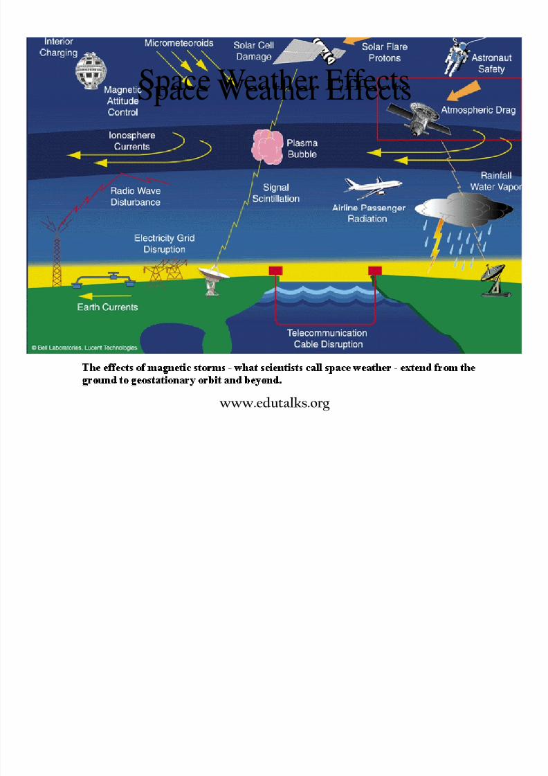
8/3/2019 Satellite Mod 1
http://slidepdf.com/reader/full/satellite-mod-1 88/165
Space Weather EffectsSpace Weather Effects
www.edutalks.org
Effect of earth on satellites
Th ff t f it ti l f i

8/3/2019 Satellite Mod 1
http://slidepdf.com/reader/full/satellite-mod-1 89/165
• The effect of gravitational force isnon uniform because of the nonuniform distribution of earth’s mass -a slight bulge at the equator, with a
difference of 21 km between polarand the equator radius.
• This deviation from spherical shape
satellite.
• The effect of earth’s gravitationalpull may be expressed as theharmonic series of the field. Thefirst term represents the principal
gravitational law and the higherorder terms in the series as theperturbations.
www.edutalks.org
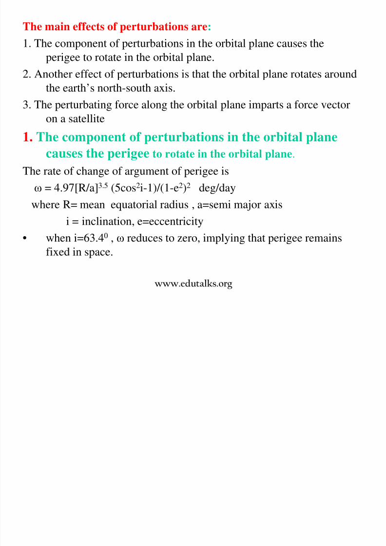
The main effects of perturbations are:
1. The component of perturbations in the orbital plane causes the
perigee to rotate in the orbital plane.
8/3/2019 Satellite Mod 1
http://slidepdf.com/reader/full/satellite-mod-1 90/165
2. Another effect of perturbations is that the orbital plane rotates around
the earth’s north-south axis.
3. The perturbating force along the orbital plane imparts a force vector
on a satellite
1. The component of perturbations in the orbital plane
causes the perigee to rotate in the orbital plane.
The rate of change of argument of perigee is
ω = 4.97[R/a]3.5 (5cos2i-1)/(1-e2)2 deg/day
where R= mean equatorial radius , a=semi major axis
i = inclination, e=eccentricity
• when i=63.40 , ω reduces to zero, implying that perigee remains
fixed in space.
www.edutalks.org
2. The orbital plane rotates around the earth’s north-south axis.
The rate of change of rotation of ascending node is
= 9.95[r/a]3.5 cos i /(1-e2)2 deg/day
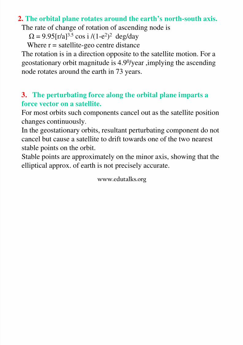
8/3/2019 Satellite Mod 1
http://slidepdf.com/reader/full/satellite-mod-1 91/165
Where r = satellite-geo centre distance
The rotation is in a direction opposite to the satellite motion. For a
geostationary orbit magnitude is 4.90 /year ,implying the ascending
node rotates around the earth in 73 years.
. e per ur a ng orce a ong e or a p ane mpar s a
force vector on a satellite.For most orbits such components cancel out as the satellite position
changes continuously.
In the geostationary orbits, resultant perturbating component do not
cancel but cause a satellite to drift towards one of the two neareststable points on the orbit.
Stable points are approximately on the minor axis, showing that the
elliptical approx. of earth is not precisely accurate.
www.edutalks.org

8/3/2019 Satellite Mod 1
http://slidepdf.com/reader/full/satellite-mod-1 92/165
Gravitational effects from heavenly bodies:
• In LEO satellites the influence of gravitational forces

8/3/2019 Satellite Mod 1
http://slidepdf.com/reader/full/satellite-mod-1 93/165
• In LEO satellites, the influence of gravitational forcesfrom sun and moon are small when compared to thegravitational force of earth.
• The order of magnitude of gravitational force of moonand sun are main sources of perturbations in GEOsatellites.
• When nearer to heavenly bodies, the gravitational pull is
stronger and hence causes a gravity gradient. maineffect of such gradient is to change the inclination of theorbit.
• The combined effect of sun and moon is to cause achange in inclination of GEO satellites between 0.750
and 0.940
www.edutalks.org
• The inclination of orbital plane caused by moon changes
cyclically between 0.480 and 0.670 with a period of 18.6
years Maximum inclination change occurred in year

8/3/2019 Satellite Mod 1
http://slidepdf.com/reader/full/satellite-mod-1 94/165
years. Maximum inclination change occurred in year1987 and minimum in Feb 1997
• The change in inclination due to sun is 0.270 /year.
Note: Among the three forces affecting the inclination (gravity pull,
sun and non spherical nature of earth) the later force has a component
in the direction opposite to the former two forces.
Hence these forces cancel out at an inclination angle of about 7.50
Thus the inclination of satellite when left uncorrected oscillates around
the stable inclination with the period of about 53 years reaching amaximum of 150 and a minimum of 00
www.edutalks.org
Atmospheric Drag
• Satellites below 2000 kilometres are actually travelling

8/3/2019 Satellite Mod 1
http://slidepdf.com/reader/full/satellite-mod-1 95/165
• Satellites below 2000 kilometres, are actually travellingthrough the Earth’s atmosphere. Collisions with air
particles, even at these high altitudes slowly act to
circularise the orbit and slow down the spacecraftcausing it to drop to lower altitudes , this effect is
• Emissions from the Sun cause the upper atmosphere toheat and expand.
• These energetic solar outputs increase dramatically
during periods of high solar activity, and may result inEarth-orbiting satellites experiencing an increase in
atmospheric drag
www.edutalks.org
A satellite orbiting the Earth would continue to orbit
forever if gravity were the only force acting on it

8/3/2019 Satellite Mod 1
http://slidepdf.com/reader/full/satellite-mod-1 96/165
forever if gravity were the only force acting on it.
Perigee remains same, Apogee decreases
www.edutalks.org
• Reduces satellite’s energy
• Changes the size (semi-major axis) and shape
(eccentricity)
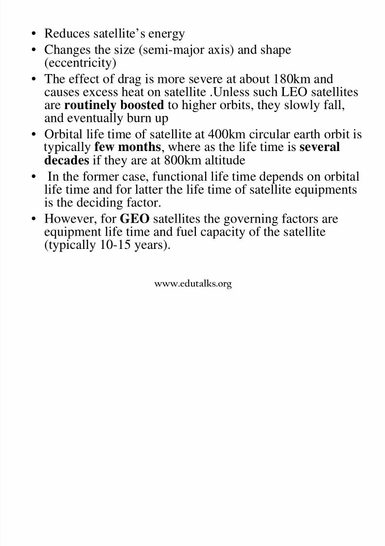
8/3/2019 Satellite Mod 1
http://slidepdf.com/reader/full/satellite-mod-1 97/165
(eccentricity)• The effect of drag is more severe at about 180km and
causes excess heat on satellite .Unless such LEO satellitesare routinely boosted to higher orbits, they slowly fall,
and eventually burn up• Orbital life time of satellite at 400km circular earth orbit is
,decades if they are at 800km altitude
• In the former case, functional life time depends on orbitallife time and for latter the life time of satellite equipmentsis the deciding factor.
• However, for GEO satellites the governing factors areequipment life time and fuel capacity of the satellite(typically 10-15 years).
www.edutalks.org
Solar radiation pressure• Solar radiation pressure is the force exerted by solar
radiation on objects within its reach
• The effect of solar radiation pressure increases as the
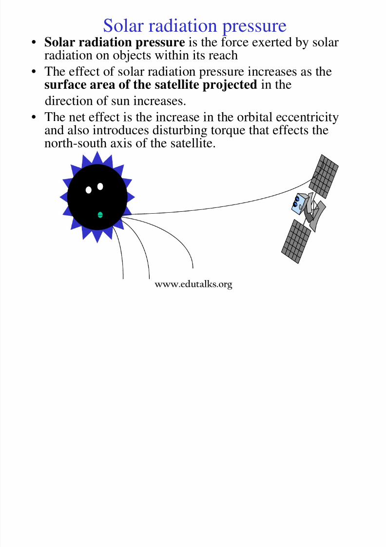
8/3/2019 Satellite Mod 1
http://slidepdf.com/reader/full/satellite-mod-1 98/165
• The effect of solar radiation pressure increases as thesurface area of the satellite projected in the
direction of sun increases.
• The net effect is the increase in the orbital eccentricityand also introduces disturbing torque that effects thenorth-south axis of the satellite.
www.edutalks.org

8/3/2019 Satellite Mod 1
http://slidepdf.com/reader/full/satellite-mod-1 99/165
Effects of Solar radiation pressure
1. HUMAN HEALTH

8/3/2019 Satellite Mod 1
http://slidepdf.com/reader/full/satellite-mod-1 100/165
1. HUMAN HEALTH• Intense solar flares produce very high energy particles
that can be as harmful to people as low-energyradiation from nuclear blasts. Earth’s atmosphere andmagnetosphere provide protection for people on theground, but astronauts in space are subject to
. high energy particles into living cells leads tochromosome damage and, potentially, cancer.
• Airline pilots and flight crews, as well as frequentfliers, also receive increased doses of radiation from
solar flares. If you were travelling in an aircraft at highaltitudes during a major solar flare, the amount of radiation you would be exposed to can be equivalent togetting a chest x-ray.
www.edutalks.org

8/3/2019 Satellite Mod 1
http://slidepdf.com/reader/full/satellite-mod-1 101/165
3. NAVIGATION
• A Global Positioning System (GPS) receiver uses radio signals fromseveral orbiting satellites to determine the range, or distance, from
each satellite, and determines from these ranges the actual position of h i

8/3/2019 Satellite Mod 1
http://slidepdf.com/reader/full/satellite-mod-1 102/165
g pthe receiver.
• The radio signals must pass through the ionosphere, the uppermostpart of the Earth’s atmosphere, and in doing so are subjected to
variations in the electron density structure of the ionosphere.
• anges n e e ec ron ens y ue o space wea er ac v y canchange the speed at which the radio waves travel introducing a“propagation delay” in the GPS signal. Changing propagation delayscause errors in the determination of the range.
• An increase in space weather activity may cause widespreaddisruption to aircraft and ship navigation and emergency locationsystems that rely heavily on satellite navigation data.
Electro-Magnetic effect
I t ti b t th E th’ ti
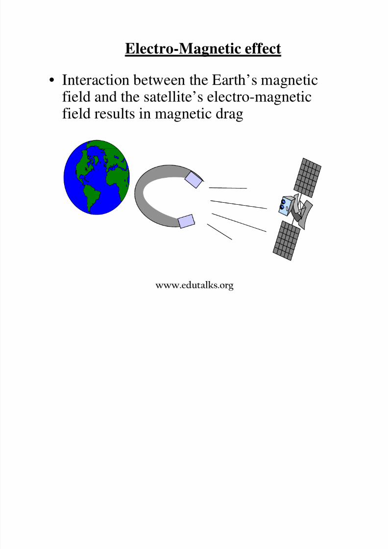
8/3/2019 Satellite Mod 1
http://slidepdf.com/reader/full/satellite-mod-1 103/165
• Interaction between the Earth’s magneticfield and the satellite’s electro-magnetic
field results in magnetic drag
www.edutalks.org
Magnetic storm
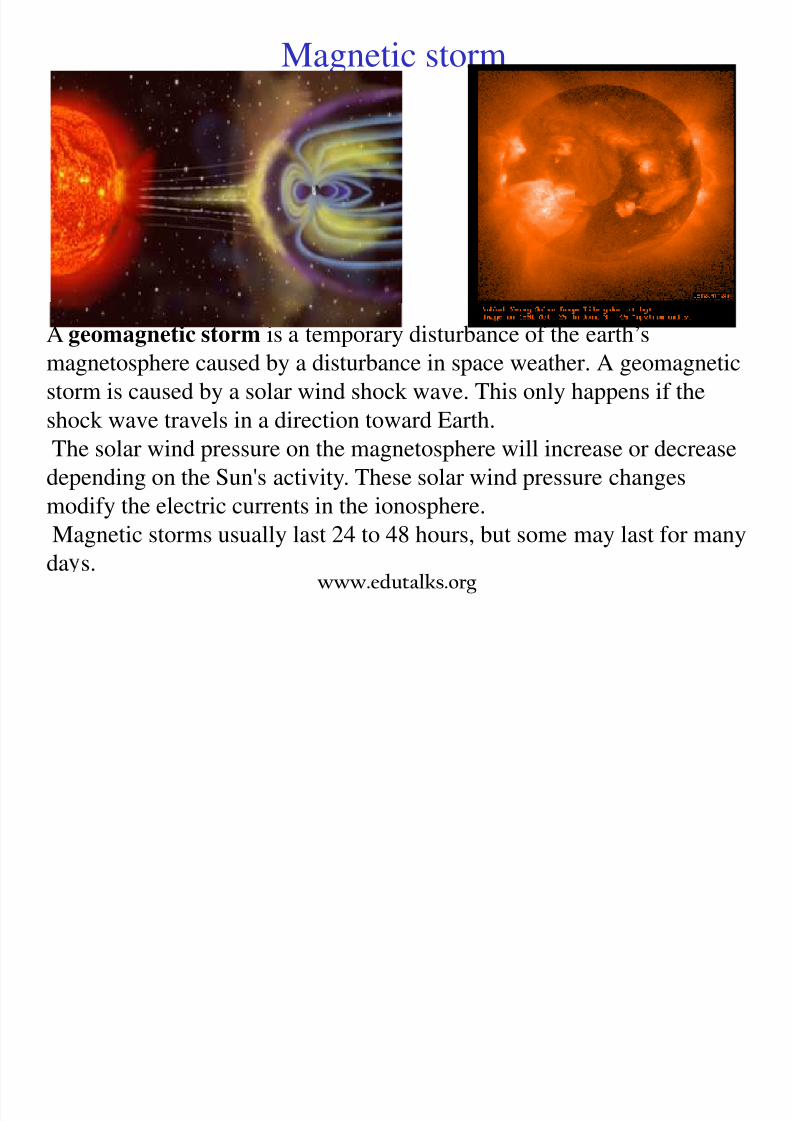
8/3/2019 Satellite Mod 1
http://slidepdf.com/reader/full/satellite-mod-1 104/165
A geomagnetic storm is a temporary disturbance of the earth’s
magnetosphere caused by a disturbance in space weather. A geomagnetic
storm is caused by a solar wind shock wave. This only happens if the
shock wave travels in a direction toward Earth.
The solar wind pressure on the magnetosphere will increase or decreasedepending on the Sun's activity. These solar wind pressure changes
modify the electric currents in the ionosphere.
Magnetic storms usually last 24 to 48 hours, but some may last for many
da s.www.edutalks.org
Non geostationary constellations
• The design of constellations can be categorized according
to inclination, altitude and eccentricity.

8/3/2019 Satellite Mod 1
http://slidepdf.com/reader/full/satellite-mod-1 105/165
, yOn the basis of inclination, two types of constellations are
designed.
Type I constellations are those having their orbital planeswith a common intersection point.
E : Polar constellations
• Type II constellations have optimized inclined orbit
constellations and distribute satellites uniformly.• Eg: inclined constellations
• Depending on altitudes, constellations may be
LEO,MEO etc.• A hybrid of orbital altitudes are also possible within asystem (A LEO satellite can be used together with ageostationary orbit satellite)
LEO Satellite coverage

8/3/2019 Satellite Mod 1
http://slidepdf.com/reader/full/satellite-mod-1 106/165
LEO Satellite coverage
Demo of satellite coverage

8/3/2019 Satellite Mod 1
http://slidepdf.com/reader/full/satellite-mod-1 107/165
www.edutalks.org
Advantages of Non-geostationary constellations
1. Since these orbits are closer to earth, the free space loss islower and hence it is possible to use hand held terminals.

8/3/2019 Satellite Mod 1
http://slidepdf.com/reader/full/satellite-mod-1 108/165
Path loss at 1.5 GHz for LEO=152.87 dB, MEO=175.96dB and GEO=187.10dB.
2. LEO and MEO reduces the propagation delay whichreduces or eliminates delay related problems.
Maximum distance between two points which view asatellite at an elevation angle 100 is
LEO (at altitude 700km) = 3885 km
MEO (10000km) = 12790 km
GEO (36000km) = 15914 kmHence note that 4 LEO satellites would cover the samegeographical distance as a single GEO. Thus LEO has 4times frequency reuse than GEO.
www.edutalks.org
4 . Distributed architecture of LEO and MEO orbits makethem more resistant to satellite failures and hence morereliable.
5. Competitions between operators has triggered a feverishtechnical regulatory and financial activity in the

8/3/2019 Satellite Mod 1
http://slidepdf.com/reader/full/satellite-mod-1 109/165
technical, regulatory and financial activity in theindustry.
Current non geostationary proposals are-
• - .bit rates communication facility. eg: ICO system
• Little LEO -Offers a low bit rate non-real time servicessuch as messaging (bit rate< 4kbps). eg. ORBCOM
• Big LEO -Offering medium bit rate interactive services
such as voice (bit rate 1-10 kbps) eg: Iridium.• Broad band LEO -Offers broadband services such asinternet high speed file download
(bit rate=16kbps to 1 Gbps) eg: Teledesic.
www.edutalks.org
Polar constellations
• A polar orbit is an orbit in which a satellite passes above or
nearly above both poles of the body (usually a planet suchas the earth) being orbited on each revolution It therefore
8/3/2019 Satellite Mod 1
http://slidepdf.com/reader/full/satellite-mod-1 110/165
as the earth) being orbited on each revolution. It thereforehas an inclination of (or very close to) 900 to the equator.
• Polar orbits are often used for earth-mapping, earthobservation, as well as some weather satellites
• The disadvantage to this orbit is that no one spot on theart s sur ace can e sense cont nuous y rom a sate te
in a polar orbit.• Polar satellites include: Defense meteorological satelliteprogram (DMSP), Landsat, SPOT and NOAA. Landsat andSPOT are Commercial polar orbiters and are intended for
geophysical remote sensing• To achieve a polar orbit requires more energy, thus more
propellant is needed than an orbit of low inclination
www.edutalks.org

8/3/2019 Satellite Mod 1
http://slidepdf.com/reader/full/satellite-mod-1 111/165

8/3/2019 Satellite Mod 1
http://slidepdf.com/reader/full/satellite-mod-1 112/165
Polar constellations

8/3/2019 Satellite Mod 1
http://slidepdf.com/reader/full/satellite-mod-1 113/165
Here : Ψ = coverage circlem = number of orbital planes
n = satellites /plane
∆ = cos
-1
[cos Ψ /cos Π /m]www.edutalks.org
Single coverage:
• Satellites in adjacent planes move in same direction, shifted with
respect to each other by half intra-orbit satellite separation (Π /m),where m = number of planes.

8/3/2019 Satellite Mod 1
http://slidepdf.com/reader/full/satellite-mod-1 114/165
The separation between adjacent planes is (Ψ+∆) and the relative
geometry remains constant because they move in phase.
• Satellites are separated by 2∆,when the satellites move in opposite
directions and the relative geometry is not constant.
The total number of satellites,N = 4 /(1-cos Ψ) ; 1.3n < m < 2.2n
In the cases of non integer, next highest integer satisfying the
inequality can be taken.If the N is much large, then the condition (n-1) Ψ + (n+1) ∆ = П
• When the coverage is required beyond a latitude λ ,the equations are –
(n-1) Ψ+(n+1) ∆ = П cos λ and N = 4cos λ /(1-cos Ψ)
• The coverage efficiency of the constellations is given by N/4П

8/3/2019 Satellite Mod 1
http://slidepdf.com/reader/full/satellite-mod-1 115/165
• The coverage efficiency of the constellations is given by N /4П
Where N = total solid angle
= solid angle bounded by a single satellite=2П(1-cos Ψ)
Triple coverage:
• The constellation geometry is similar to single coverage case, with atleast three satellites must be visible at all points.
• The coverage angle is adjusted such that at least 3 satellites lie within
angle Ψ of each point of set.
• The resulting relationship for providing triple coverage from pole up
to latitude λ is
N = 11cos λ /(1-cos λ ) ; 1.4n < mcos λ < 2.4n
www.edutalks.org
Inclined orbit
• A satellite is said to occupy an inclined orbit around the earth if the orbit exhibits an angle other than zero degrees with the
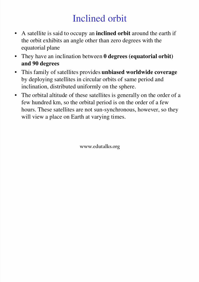
8/3/2019 Satellite Mod 1
http://slidepdf.com/reader/full/satellite-mod-1 116/165
equatorial plane
• They have an inclination between 0 degrees (equatorial orbit)
and 90 degrees
• This family of satellites provides unbiased worldwide coverage
by deploying satellites in circular orbits of same period and
inclination, distributed uniformly on the sphere.• The orbital altitude of these satellites is generally on the order of a
few hundred km, so the orbital period is on the order of a few
hours. These satellites are not sun-synchronous, however, so they
will view a place on Earth at varying times.
www.edutalks.org

8/3/2019 Satellite Mod 1
http://slidepdf.com/reader/full/satellite-mod-1 117/165

8/3/2019 Satellite Mod 1
http://slidepdf.com/reader/full/satellite-mod-1 118/165
Hybrid constellations
• This combines the various types orbits for full earthcoverage

8/3/2019 Satellite Mod 1
http://slidepdf.com/reader/full/satellite-mod-1 119/165
• These orbits have different orbital period
• Eg: using circular orbits for covering equatorial regionsand elliptical orbits for higher altitude regions
Eg: using GEO for covering equatorial regions and
inclined orbits for polar regions
www.edutalks.org

8/3/2019 Satellite Mod 1
http://slidepdf.com/reader/full/satellite-mod-1 120/165
Footprint and spot beams
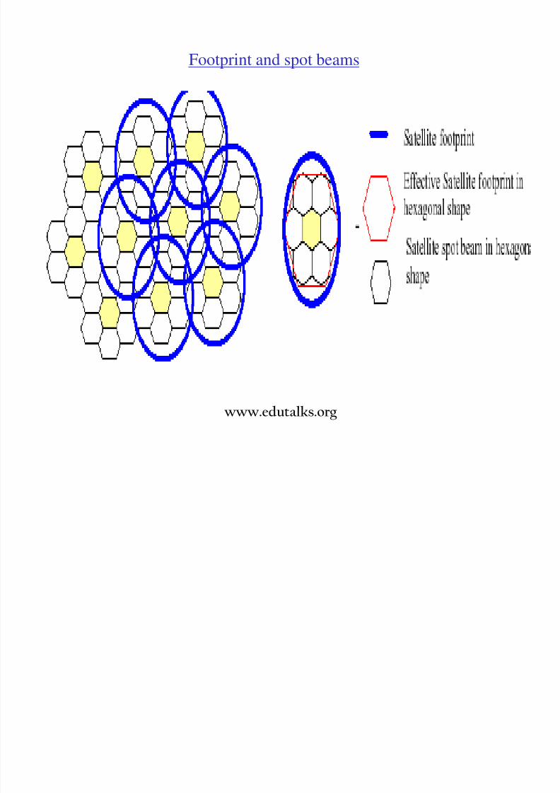
8/3/2019 Satellite Mod 1
http://slidepdf.com/reader/full/satellite-mod-1 121/165
www.edutalks.org
Constellations for store and forward system:
• Systems which do not require real time coverage (messaging/paging)is less stringent because gaps in coverage are allowed, provided at
least one satellite is visible within (ta-td) where ta=specified end toend delay , td=delay in message transfer

8/3/2019 Satellite Mod 1
http://slidepdf.com/reader/full/satellite-mod-1 122/165
• Eg :A single satellite in polar orbit can cover every regions of earthwithin a time dependent on the orbital period
,
reliable, two-way data communications
services around the world through aglobal network of 29 low-earth orbit
(LEO) satellites and accompanying
ground infrastructure. The system can
send and receive short messages,
between six bytes and several kilobytes
www.edutalks.org
Random and phased constellations
• Constellations can be categorized on the basis of phase relationshipbetween satellites with respect of each other.
• In random constellation all or some constellation parameters such
8/3/2019 Satellite Mod 1
http://slidepdf.com/reader/full/satellite-mod-1 123/165
• In random constellation all or some constellation parameters suchas altitude inclination, inter orbital plane separation and inter satellite
phase are chosen at random.• In phased constellation all these parameters are well defined.
Random constellations are sim ler to maintain but are inefficient interms of coverage property and tend to randomly crowd the celestial
sphere around the chosen altitude.
www.edutalks.org
Design considerations of a non GEO satellite systems
1.Traffic distribution and coverage:
• A constellation design depends on service area and geographicaldistribution of traffic within that area.

8/3/2019 Satellite Mod 1
http://slidepdf.com/reader/full/satellite-mod-1 124/165
• A worldwide coverage is essential for an operator interested inglobal operations, but regional operator is interested in only aspecific region. Hence the constellations are completely different.
• Good RF visibility ensures adequate signal strength before aconnection is established and the increase in spectrum reuse.
• Complexity in coverage design is the dynamic variation in positionof the footprint of each satellite and the constellation as a whole,making the geometric relationship time dependent.
• Hence an estimate can be made on the basis of known growth trends
from existing systems, population density, per capita income,existing infrastructure, market segmentation due to competition andprevailing economic /political condition of the target market.
www.edutalks.org

8/3/2019 Satellite Mod 1
http://slidepdf.com/reader/full/satellite-mod-1 125/165
8/3/2019 Satellite Mod 1
http://slidepdf.com/reader/full/satellite-mod-1 126/165
6. Spectrum availability:
• Frequency reusability can be increased by spatial/polarizationdiversity
• This is achieved by using spot and shaped beams
• For a given spot beam size lower altitude constellations can give
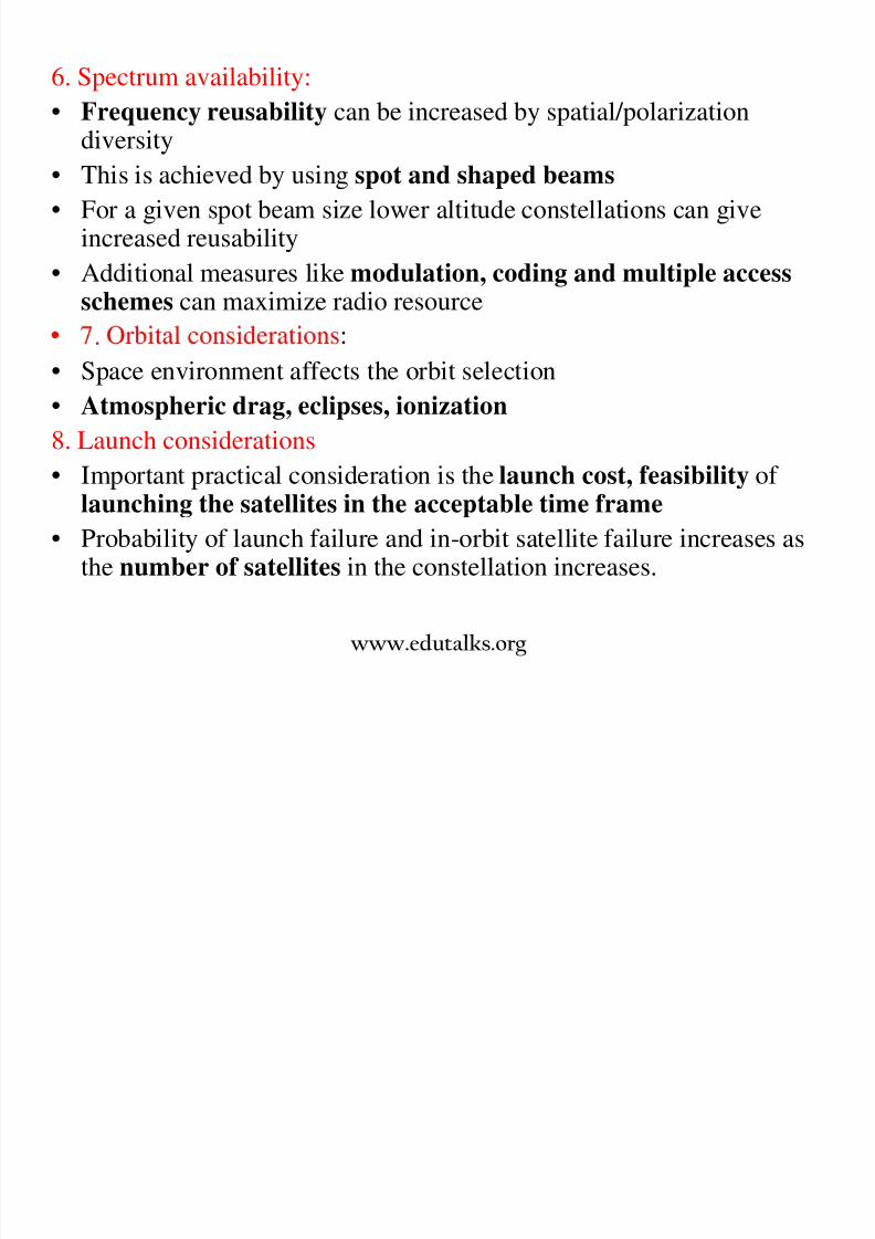
8/3/2019 Satellite Mod 1
http://slidepdf.com/reader/full/satellite-mod-1 127/165
• For a given spot beam size lower altitude constellations can giveincreased reusability
• Additional measures like modulation, coding and multiple accessschemes can maximize radio resource
.
• Space environment affects the orbit selection
• Atmospheric drag, eclipses, ionization
8. Launch considerations
• Important practical consideration is the launch cost, feasibility of
launching the satellites in the acceptable time frame• Probability of launch failure and in-orbit satellite failure increases as
the number of satellites in the constellation increases.
www.edutalks.org

8/3/2019 Satellite Mod 1
http://slidepdf.com/reader/full/satellite-mod-1 128/165
Problems
Q1. Find out the radius of a geostationarysatellite orbit

8/3/2019 Satellite Mod 1
http://slidepdf.com/reader/full/satellite-mod-1 129/165
satellite orbit.
Given:
T = 23Hr 56Min 4.1Sec
G = 6.672 X10⁻¹¹ m3 /kg/s2
M = 5974 X1024 kg
r = 6378.1414 km
take µ = √GM
www.edutalks.org
Answer:
T2 = 4 П2 .(R)3
µR = [T√GM]2/3
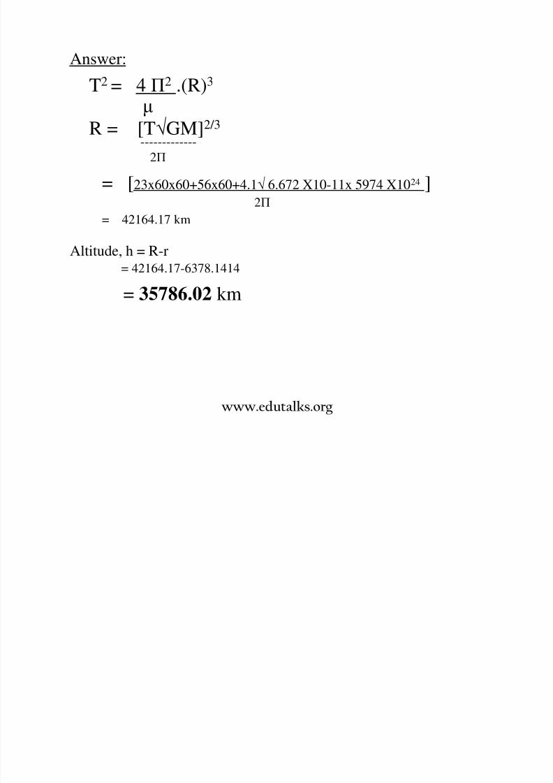
8/3/2019 Satellite Mod 1
http://slidepdf.com/reader/full/satellite-mod-1 130/165
[ ]-------------
2П
= [23x60x60+56x60+4.1√ 6.672 X10-11x 5974 X1024 ]2П
= 42164.17 km
Altitude, h = R-r= 42164.17-6378.1414
= 35786.02 km
www.edutalks.org
8/3/2019 Satellite Mod 1
http://slidepdf.com/reader/full/satellite-mod-1 131/165

8/3/2019 Satellite Mod 1
http://slidepdf.com/reader/full/satellite-mod-1 132/165
Q3. Calculate the apogee and perigee heightsfor the given orbital parameters.
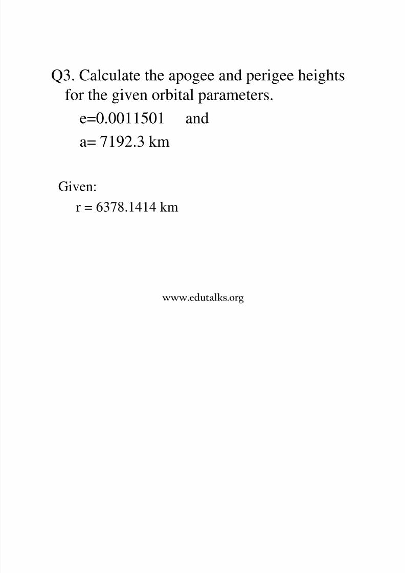
8/3/2019 Satellite Mod 1
http://slidepdf.com/reader/full/satellite-mod-1 133/165
g p
e=0.0011501 and
a= 7192.3 km
Given:
r = 6378.1414 km
www.edutalks.org
Answer:
ra=a(1+e) = 7200.57 km

8/3/2019 Satellite Mod 1
http://slidepdf.com/reader/full/satellite-mod-1 134/165
rp= a(1-e) = 7184.03 km
, a a – .
Perigee height, hp = rp – r = 805.89 km
www.edutalks.org
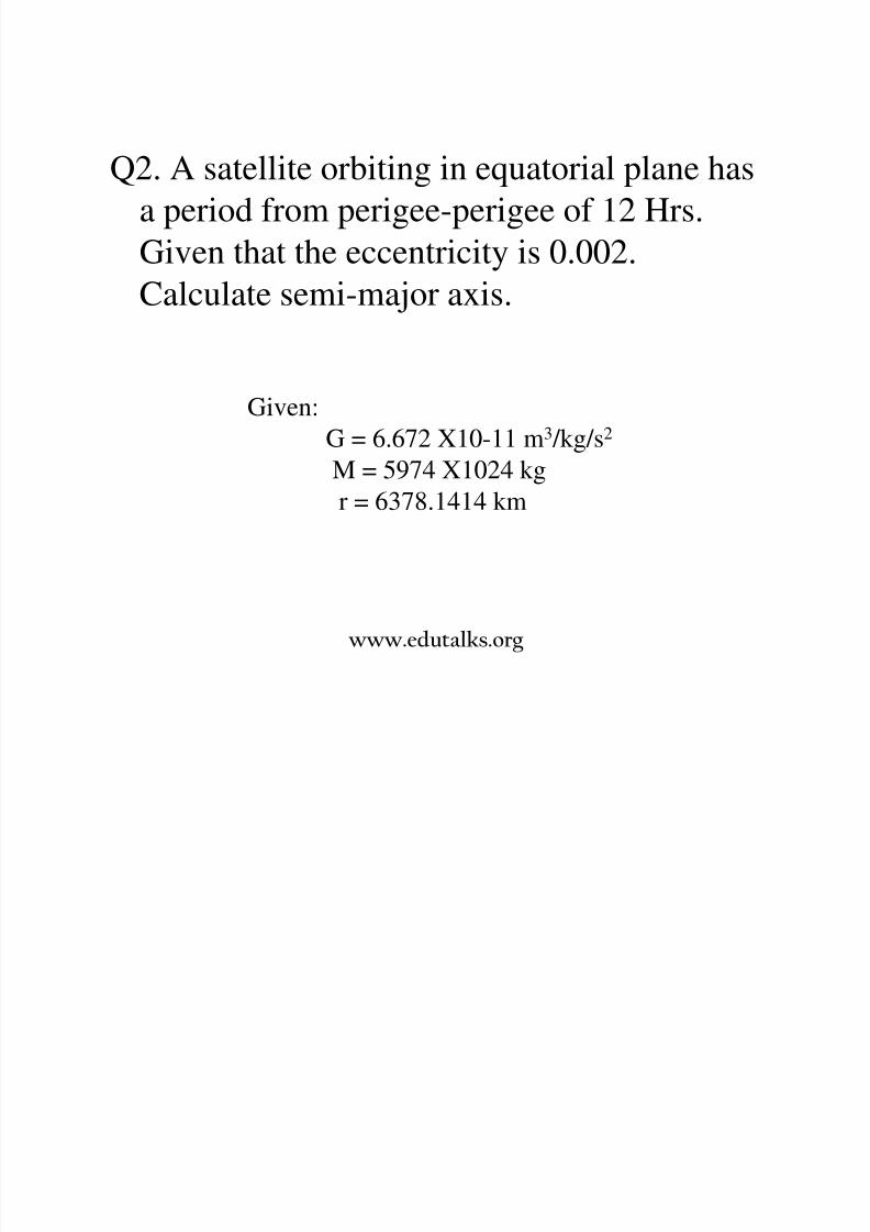
Q4. A satellite is in elliptical orbit with aperigee of 1000 km and an apogee of 4000
k U i th di f 6378 14 k
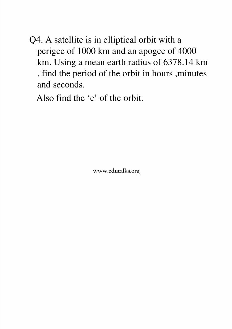
8/3/2019 Satellite Mod 1
http://slidepdf.com/reader/full/satellite-mod-1 135/165
km. Using a mean earth radius of 6378.14 km
, find the period of the orbit in hours ,minutesand seconds.
Also find the ‘e’ of the orbit.
www.edutalks.org

8/3/2019 Satellite Mod 1
http://slidepdf.com/reader/full/satellite-mod-1 136/165
Communication Satellites

8/3/2019 Satellite Mod 1
http://slidepdf.com/reader/full/satellite-mod-1 137/165
www.edutalks.org
Communication satellites (comsat)
• Satellite is a RF repeater in orbit.
• The design of a satellite is governed by the communication capacity,physical environment in which it is operated and state of technology.
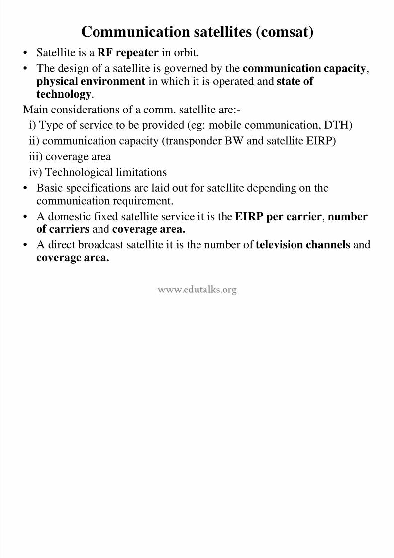
8/3/2019 Satellite Mod 1
http://slidepdf.com/reader/full/satellite-mod-1 138/165
Main considerations of a comm. satellite are:-
i) Type of service to be provided (eg: mobile communication, DTH)ii) communication capacity (transponder BW and satellite EIRP)
iii) coverage area
iv) Technological limitations• Basic specifications are laid out for satellite depending on the
communication requirement.
• A domestic fixed satellite service it is the EIRP per carrier, number
of carriers and coverage area.• A direct broadcast satellite it is the number of television channels and
coverage area.
First TV image of weather (1960)

8/3/2019 Satellite Mod 1
http://slidepdf.com/reader/full/satellite-mod-1 139/165
www.edutalks.org
First complete view of world’s weather, photographed by
TIROS 9 (13/2/1965).
Image assembled from 450 individual photographs

8/3/2019 Satellite Mod 1
http://slidepdf.com/reader/full/satellite-mod-1 140/165
www.edutalks.org
Environmental Conditions:• A spacecraft must be reliable in all types of environments beginning from
launch to the in-orbit deployment and throughout its operation phase.
Most important stresses are-
a) Zero gravity :-
• At GEO, gravitational force is negligible giving rise to zero gravity effects.
• Major effect is on liquid fuel flow and hence external means are to be

8/3/2019 Satellite Mod 1
http://slidepdf.com/reader/full/satellite-mod-1 141/165
• Major effect is on liquid fuel flow and hence external means are to beprovided for liquid flow.
• The absence of gravity facilitates operation of the deployment mechanismsused for stowing antennas and solar panels during launch.
mosp er c pressure an empera ure :-• At high altitudes, atmospheric pressure is extremely low (10-7 torr).
• This makes thermal conduction negligible and increase friction betweensurfaces.
• Hence special materials are used for lubrication of moving parts.
• However, pressure inside the spacecraft is higher because of out gassing of
electronic components.• The temperature of a spacecraft is mainly affected by heat from sun and
various spacecraft subsystems.
• The excursion in the external temperature varies from 330-350K duringsunlight and 95-120K during eclipses.
www.edutalks.org
c) Space Particles :-
• Various types of particles like cosmic rays, protons, electrons, meteoroids,manmade debris etc exist in space.
• Main effect of bombardment of particles on a satellite is the degradation of
solar cells and certain solid state components within the satellite.• Effect of meteoroids is negligible in GEO satellites.
d) Magnetic fields :-
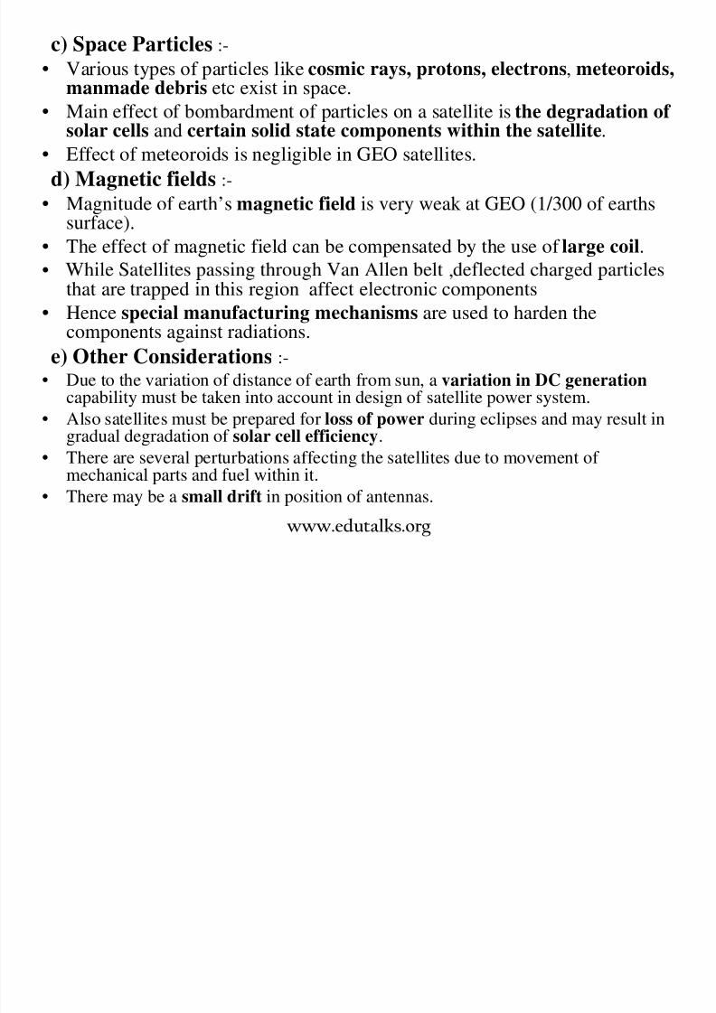
8/3/2019 Satellite Mod 1
http://slidepdf.com/reader/full/satellite-mod-1 142/165
• Magnitude of earth’s magnetic field is very weak at GEO (1/300 of earths
surface).• The effect of magnetic field can be compensated by the use of large coil.
• ,that are trapped in this region affect electronic components
• Hence special manufacturing mechanisms are used to harden thecomponents against radiations.
e) Other Considerations :-
• Due to the variation of distance of earth from sun, a variation in DC generationcapability must be taken into account in design of satellite power system.
• Also satellites must be prepared for loss of power during eclipses and may result ingradual degradation of solar cell efficiency.
• There are several perturbations affecting the satellites due to movement of mechanical parts and fuel within it.
• There may be a small drift in position of antennas.
www.edutalks.org
Life time and reliability
• Lifetime of a geostationary satellite is determined by the maximumacceptable deviation in inclination and orbital location.
• Satellite is maintained in its orbital location by firing thrustersregularly, using stored fuel
• Hence the operational lifetime of a satellite is determined by-
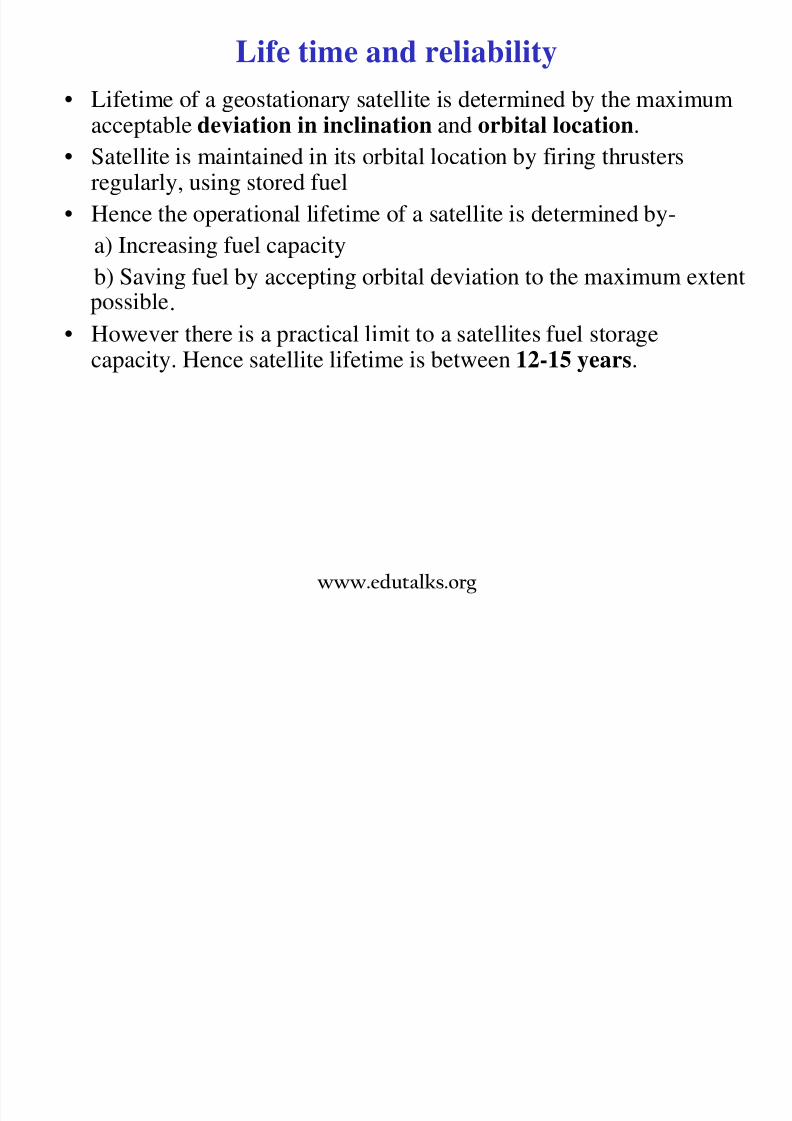
8/3/2019 Satellite Mod 1
http://slidepdf.com/reader/full/satellite-mod-1 143/165
Hence the operational lifetime of a satellite is determined by
a) Increasing fuel capacityb) Saving fuel by accepting orbital deviation to the maximum extent
.
• However there is a practical limit to a satellites fuel storage
capacity. Hence satellite lifetime is between 12-15 years.
www.edutalks.org
Reliability
• The overall reliability of a satellite is governed by its critical
components.
• Reliability is improved by employing redundancy in the critical sub
systems and in components such as TWT amplifiers.

8/3/2019 Satellite Mod 1
http://slidepdf.com/reader/full/satellite-mod-1 144/165
• Reliability is defined as the probability that a given component/system
performs its function within a specified time t.
• R= where λ = failure rate of a componentt
dt− λ
• Unit of λ is specified as FIT, the number of failures in 109 Hr.
www.edutalks.org
8/3/2019 Satellite Mod 1
http://slidepdf.com/reader/full/satellite-mod-1 145/165
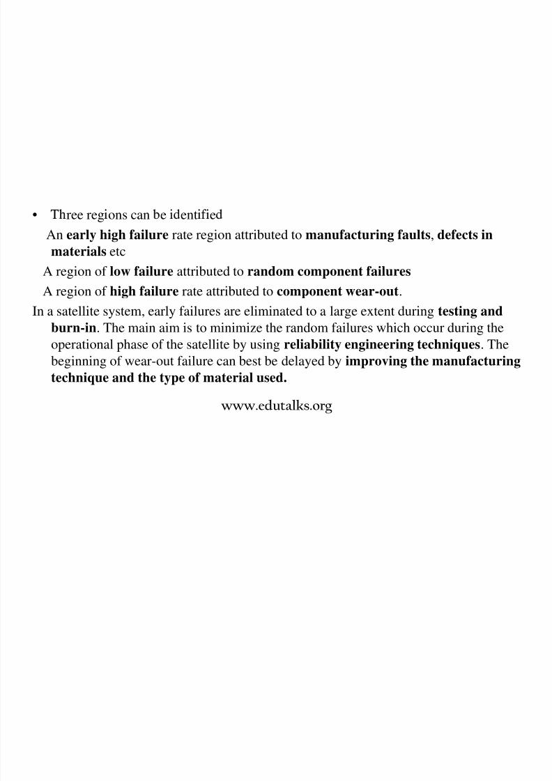
• ree reg ons can e ent e
An early high failure rate region attributed to manufacturing faults, defects in
materials etc
A region of low failure attributed to random component failures
A region of high failure rate attributed to component wear-out.
In a satellite system, early failures are eliminated to a large extent during testing and
burn-in. The main aim is to minimize the random failures which occur during theoperational phase of the satellite by using reliability engineering techniques. The
beginning of wear-out failure can best be delayed by improving the manufacturing
technique and the type of material used.
www.edutalks.org
• The reliability can be expressed as
R = e-λ t = e-t/m ; where m =1/ λ (mean time between failures)
• When several components or sub-systems are connected in series, the
overall reliability is
Rs=R1 R2…….Rn where Ri is the reliability of the ith component.
• In terms of the failure rate :

8/3/2019 Satellite Mod 1
http://slidepdf.com/reader/full/satellite-mod-1 146/165
• In terms of the failure rate :
Rs= e-(λ 1+ λ 2+… λ n)t
• Parallel redundancy is useful when the reliability of an individual
subsystem is high.
• If Qi is the unreliability of the ith parallel element, the probability that
all units will fail is the product of the individual unreliabilities
Qs=Q1 Q2…Qi
• When the unreliabilities of all elements are equal, this expression
reduces to Qs = Qi ;Where Q is the unreliability of each element.Therefore the reliability is
R = 1-Qs
= 1-i
=1- 1- Ri
=1- 1-e-λ t
iwww.edutalks.org
A Typical reliability model of a Geostationary Satellite:
• All the major sub-systems are shown in series.

8/3/2019 Satellite Mod 1
http://slidepdf.com/reader/full/satellite-mod-1 147/165
Simplified reliability model • Applying the equation for series and parallel combination, the
Rs =RRXRTX [1-(1-RT)2]
• When RT =0.9,reliability of transponder increases to 0.99• Figure of merit, Fγ = r/M ;where r = R’/R
R’= reliability with redundancy employed
R= reliability without employing redundancy
M= increase in mass due to added redundancy
• The addition of redundant equipment increases the cost of the
transponder
www.edutalks.org

8/3/2019 Satellite Mod 1
http://slidepdf.com/reader/full/satellite-mod-1 148/165
www.edutalks.org

8/3/2019 Satellite Mod 1
http://slidepdf.com/reader/full/satellite-mod-1 149/165
www.edutalks.org

8/3/2019 Satellite Mod 1
http://slidepdf.com/reader/full/satellite-mod-1 150/165
Back up slides
www.edutalks.org

8/3/2019 Satellite Mod 1
http://slidepdf.com/reader/full/satellite-mod-1 151/165
www.edutalks.org
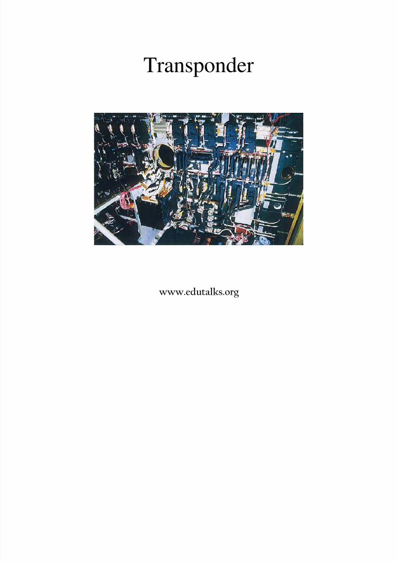
Transponder
8/3/2019 Satellite Mod 1
http://slidepdf.com/reader/full/satellite-mod-1 152/165
www.edutalks.org
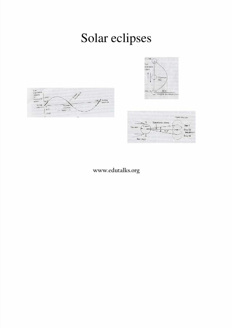
Solar eclipses
8/3/2019 Satellite Mod 1
http://slidepdf.com/reader/full/satellite-mod-1 153/165
www.edutalks.org

8/3/2019 Satellite Mod 1
http://slidepdf.com/reader/full/satellite-mod-1 154/165
www.edutalks.org
----Introduction to Solar System Dynamics----
rp ra
Basic orbital elements (ellipse)
e=0: circle
e<1: ellipse

8/3/2019 Satellite Mod 1
http://slidepdf.com/reader/full/satellite-mod-1 155/165
e e pse
e=1: parabola
e>1: hyperbola
vr
2.a
a: semimajor axis
e: eccentricity
v: true anomaly (0…360 deg)
rp: Radius of periapsis(perihelion)
ra: Radius of apoapsis(aphelion)
)1(
)1(
ear
ear
a
p
+=
−=ve
ear
cos1
)1(2
−
−=
www.edutalks.org
----Introduction to Solar System Dynamics----
Useful orbital parameters (elliptical orbit)
1) Velocity:
−=ar
GM u12
M: mass of central body
m: mass of orbiting body
r: distance of m from M

8/3/2019 Satellite Mod 1
http://slidepdf.com/reader/full/satellite-mod-1 156/165
2) Period: aT
3
2π =
(M>>m)
3) Energy:
4) Angularmomentum:
a
GMm E
2−=
)1(
,2ea M Gm L
ur m L
−⋅⋅⋅=
×⋅=r r
(Constant!)
(Constant!)
www.edutalks.org

8/3/2019 Satellite Mod 1
http://slidepdf.com/reader/full/satellite-mod-1 157/165
www.edutalks.org
Spin stabilization
• With spin stabilization, the entire spacecraft rotates around its own
vertical axis, spinning like a top. This keeps the spacecraft's orientationin space under control.
• The spinning spacecraft resists perturbing forces

8/3/2019 Satellite Mod 1
http://slidepdf.com/reader/full/satellite-mod-1 158/165
The spinning spacecraft resists perturbing forces.
• Desi ners of earl satellites used s in-stabilization for their satellites,
which most often have a cylinder shape and rotate at one revolution
every second.
• Spin stabilization was used for NASA's Pioneer 10 and 11 spacecraft,
the Lunar Prospector, and the Galileo Jupiter orbiter.
• The advantage of spin stabilization is that it is a very simple way to
keep the spacecraft pointed in a certain direction.
• A disadvantage of this stabilization is that the satellite cannot use
large solar arrays to obtain power from the Sun. Thus, it requires
8/3/2019 Satellite Mod 1
http://slidepdf.com/reader/full/satellite-mod-1 159/165
large amounts of battery power.
antennas also must perform “despin” maneuvers so that antennas or
optical instruments point at their desired targets.
Reaction wheel stabilisation
• With three-axis stabilization, satellites have small spinning wheels,
called reaction wheels or momentum wheels, that rotate so as tokeep the satellite in the desired orientation in relation to the Earthand the Sun.
• If satellite sensors detect that the satellite is moving away from the
8/3/2019 Satellite Mod 1
http://slidepdf.com/reader/full/satellite-mod-1 160/165
proper orientation, the spinning wheels speed up or slow down toreturn the satellite to its correct position.
-continually nudge the spacecraft back and forth to keep it within a
range of allowed positions.• Voyagers 1 and 2 stay in position using 3-axis stabilization.
• An advantage of 3-axis stabilization is that optical instruments
and antennas can point at desired targets without having to perform“despin” maneuvers
www.edutalks.org
Alignment
• There are a number of components which needalignment
– Solar panels

8/3/2019 Satellite Mod 1
http://slidepdf.com/reader/full/satellite-mod-1 161/165
– Antennae
ese ve o o e e s o e s y
different times, so the problem is not trivial
www.edutalks.org
Solar and sidereal day
8/3/2019 Satellite Mod 1
http://slidepdf.com/reader/full/satellite-mod-1 162/165
www.edutalks.org

8/3/2019 Satellite Mod 1
http://slidepdf.com/reader/full/satellite-mod-1 163/165
ORBITAL ELEMENTSKeplerian Elements: True Anomaly
ν νν ν

8/3/2019 Satellite Mod 1
http://slidepdf.com/reader/full/satellite-mod-1 164/165
i
ΩΩΩΩ
www.edutalks.org

8/3/2019 Satellite Mod 1
http://slidepdf.com/reader/full/satellite-mod-1 165/165
Prepared by:
r s . .
Assistant Professor in ECE
Jyothi Engineering College, Cheruthuruthy