schedule 1 - location and protocol for vegetation ... - … emmp... · schedule 1 location and...
TRANSCRIPT

October 2007 Ver 1 1
Schedule 1 Location and protocol for clearance of vegetation along the onshore cable route Ver: 1 Date: 24th October 2007 Introduction Restrictions have been agreed with Natural England and reinforced through condition to the effect that no works are to be undertaken within The Swale SPA and Ramsar site, or within 500 metres of the seawall boundary, during the period 1 October – 31 March. One of two exceptions to this is works associated with the clearance of vegetation in advance of cable installation (i.e. the installation onshore of power cables from the wind farm). The reason for excluding this clearance from the condition is to enable vegetation to be cleared outside of the breeding season with the intention of deterring sensitive bird species, particularly Marsh Harrier from establishing nests close to areas that might subsequently be affected by disturbance arising from construction activities. As all birds, their nests and eggs are afforded protection under the Wildlife and Countryside Act 1981, as updated by the Countryside and Rights of Way Act 2000, it is an offence to:
• Intentionally kill, injure or take any wild bird; • Intentionally take, damage or destroy the nest of any wild bird while it is in
use or being built; and • Intentionally take or destroy the egg of any wild bird.
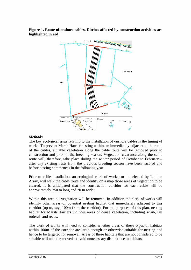
Furthermore, special penalties are available for offences related to bird species listed on Schedule 1 of the Act, for which there are additional offences of disturbing these birds at their nests, or their dependent young. In addition to Marsh Harrier the other ‘Schedule 1’ species known to nest within the cable route is Bearded Tit which is associated with reed-beds in borrow-pits and some ditches. This Schedule outlines the approach and timing of vegetation clearance to ensure that the risk of disturbance to breeding birds (with particular reference to Marsh Harrier and Bearded Tit) arising from cable installation is minimised. Area Affected The large majority of the area affected comprises agricultural land (Figure 1). In addition the route will also cross borrow pits and several drains (referred to here as ditches). Ditches that will be affected by construction works are highlighted in Figure 1 in red. Protocols for construction works within borrow-pits and ditches are dealt with separately in Schedule 3.
October 2007 Ver 1 2
Figure 1. Route of onshore cables. Ditches affected by construction activities are highlighted in red
Methods The key ecological issue relating to the installation of onshore cables is the timing of works. To prevent Marsh Harrier nesting within, or immediately adjacent to the route of the cables, suitable vegetation along the cable route will be removed prior to construction and prior to the breeding season. Vegetation clearance along the cable route will, therefore, take place during the winter period of October to February – after any existing nests from the previous breeding season have been vacated and before nesting commences in the following year. Prior to cable installation, an ecological clerk of works, to be selected by London Array, will walk the cable route and identify on a map those areas of vegetation to be cleared. It is anticipated that the construction corridor for each cable will be approximately 750 m long and 20 m wide. Within this area all vegetation will be removed. In addition the clerk of works will identify other areas of potential nesting habitat that immediately adjacent to this corridor (up to, say, 100m from the corridor). For the purposes of this plan, nesting habitat for Marsh Harriers includes areas of dense vegetation, including scrub, tall ruderals and reeds. The clerk of works will need to consider whether areas of these types of habitats within 100m of the corridor are large enough or otherwise suitable for nesting and hence to be targeted for removal. Areas of these habitats that are not considered to be suitable will not be removed to avoid unnecessary disturbance to habitats.

October 2007 Ver 1 3
If a long period of inactivity is anticipated between vegetation clearance and cable installation, then the cable route should be periodically visited to ensure that there is no indication of likely nesting activity. If there is a concern that breeding may take place then further steps may be required to deter nest establishment (visual deterrents, such as, mirrors/reflectors, tapes and human presence are preferred, although auditory techniques may also be considered if visual deterrents prove ineffective). This process will be repeated for each year that cable installation takes place. Habitats, where possible, should be returned to their original condition following construction in each year. To ensure that the construction corridor returns to its former condition in the shortest possible time, specific methods of soil storage management should be undertaken for the cable trenches, including:
• Segregation of top-soils from sub-soils to ease their return in the correct order when burying cables.
• Avoid over compaction of replaced soils. • Control of erosion of soils and maintenance of soil moisture. • Management of vegetation growth.
Monitoring As these works are precautionary it is considered that there is no need for additional monitoring, other than that required for birds under Schedule 2 (ornithology). Reporting No reporting will be necessary for these remedial works to Natural England or Swale Borough Council
October 2007 Ver 1 1
Schedule 2 Onshore ornithological monitoring Ver: 1 Date: 24th October 2007 Introduction The monitoring requirements for the onshore components of London Array are outlined in the Environmental Statement and in English Nature’s letter to Swale Borough Council of 14th July 2005. Letter dated 14th July 2005 from Lionel Solly to SBC Ornithological surveys of the foreshore, inter-tidal and onshore areas should be carried out between October – March in each year of the construction period, and for at least one year following completion of the works; survey methodology and count areas should correspond with those reported in the ES. Particular regard should be given to the use of areas affected in the preceding summer, eg those parts of the foreshore and inter-tidal area affected by cable installation. The results of these surveys should be reported to the appropriate regulatory authority/ies within a specified timeframe, agreed between the parties, and should be used to inform implementation of the later phases of the development (where appropriate) [Footnote: Monitoring may indicate that particular activities have a greater or lesser impact than predicted; and it may then be appropriate to modify the way that the activity is carried out.] Similar requirements were established with respect to National Grid’s proposed over-head line diversion works under the Section 37 consenting regime. Construction works associated with the overhead line diversion will commence in winter 07/08, these works will include establishment of the access road, construction of a new junction on Seasalter Road, replacement of existing towers and diversion of the overhead line. To comply with the condition requiring monitoring during October – March of each year of the construction period, monitoring will, therefore, commence in October 2007. In this first year, monitoring will focus on those areas within which the access track and overhead line diversion works will take place. In subsequent years the monitoring survey area will be expanded to include areas within which cable installation and substation construction will take place. This Schedule is, therefore, divided into two parts, the first part (Schedule 2A) relates to the first year of monitoring (winter 2007/08) and the second part (Schedule 2B) relates to all subsequent years of monitoring.

October 2007 Ver 1 2
Key species The wintering birds surveys undertaken in connection with the environmental impact assessment of the onshore works for London Array identified that the inter-tidal area within the survey boundary supports the following species named in the designation of the SPA and Ramsar site:
• dark-bellied brent goose • wigeon • oystercatcher • knot • dunlin
Similarly the winter surveys recorded the following bird species on arable land and grazing marsh on the landward side of the sea wall named in the reasons for designation of the SPA and Ramsar site:
• dark-bellied brent goose • lapwing • golden plover
Small numbers of the following bird species were recorded using the intertidal area and terrestrial habitat during the winter bird survey:
great-crested grebe, shelduck, eider, grey plover, bar-tailed godwit, cormorant, teal, common scoter, sanderling, curlew, little egret, mallard, velvet scoter, redshank, grey heron, pintail, red-breasted merganser, turnstone, greylag goose, shoveler, ringed plover, and black-tailed godwit.

October 2007 Ver 1 3
Schedule 2A – Monitoring in Winter 2007/08 This part of the Schedule relates to monitoring undertaken during the winter of 2007/08. It focuses on onshore areas affected by works undertaken in connection with the establishment of the access road and overhead line diversion. Monitoring for subsequent years is addressed in Schedule 2B. Monitoring survey area The extent of the survey area for the first year of monitoring is indicated in Figure 1. To structure the recording of the results of bird surveys, the monitoring area is divided into survey sectors. For continuity, these sectors will have the same boundaries as those used for baseline surveys undertaken for the environmental impact assessment of the onshore components of London Array. As works undertaken in the period covered by this part of the schedule (winter 2007/08) will be limited in their extent, the monitoring surveys will focus on a subset of the sectors employed in those baseline surveys, as follows:
• Onshore – Sectors D, E, F, H, K, Q, V, W, 1, 2, 3, 4, 9, 10, 11 and 23 • In addition 3 new sectors have been created to the east of Seasalter Road to
encompass the minor works that will be undertaken at tower ZV168 in the first year of construction only, these have been labelled X, Y and Z respectively.
Methods Surveys will be undertaken within the period 1st October 2007 – 31st March 2008 reflecting the winter and passage periods within which most birds associated with the Ramsar site and SPA are present in greatest abundance. Surveys will be undertaken twice monthly. Surveys will be undertaken at high tide. The survey will commence 2 hours before high tide until 2 hours after high tide (4 hours total). Four consecutive counts of 1 hour duration will be undertaken of the monitoring survey area. The focus of monitoring is on waterbirds, particularly those species populations which form part of the interest features of the Ramsar site and SPA, and other species of importance for conservation. Other species will be given a lower priority. The surveyor will undertake the count from suitable vantage points within the monitoring survey area. In order to cover the whole monitoring survey area, it may be necessary to change location. This will be done so as to minimise disturbance. To the extent possible, surveys will avoid periods of reduced visibility. During each survey visit the following information will be recorded:
• Date • Survey sector • Time period • Species present • Number of individuals • Behaviour
October 2007 Ver 1 4
• Weather conditions • Any disturbance events • Any other important observations
Reporting A monitoring report will be produced within 3 months of the completion of the winter survey. The report will clearly describe:
• Methods employed • Results – data will be presented as peak and mean counts per sector and for
any other relevant logical groupings of sectors • Any important observations will be highlighted • The key implication of the survey results • The need (or otherwise) for changes in construction activities

RPS October 2007 Ver 3.0 5
Figure 1. Schedule 2A: Ornithological monitoring survey area

RPS October 2007 Ver 3.0 6
Schedule 2B – Monitoring in Winter 2008/09 and subsequent years This part of the Schedule addresses monitoring undertaken after the winter of 2007/08, and in accordance with London Array’s programme it assumes that construction of the substation works will commence in Autumn 2008. In accordance with conditions attached to the consent for the construction of the onshore components of London Array this monitoring will be undertaken during each year of construction and for one year thereafter. As the area affected by cable installation includes inter-tidal habitats that are available to birds at low tide, the surveys will include both a low tide and high tide component. Monitoring survey area The extent of the survey area for subsequent years of monitoring is indicated in Figure 2. Low tide counts At low tide surveys will focus on inter-tidal habitats. surveys will therefore be undertaken within foreshore sectors only: 1.1, 1.2, 2.1, 2.2, 3.1, 3.2, 4.1 and 4.2 High tide counts High tide surveys will include both onshore survey sectors and inter-tidal areas (to the extent that these are exposed at high tide), comprising:
• Foreshore (to the extent that they are exposed): Sectors 1.1, 1.2, 2.1, 2.2, 3.1, 3.2, 4.1 and 4.2
• Onshore Sectors A, B, C, D, E, F, G, H, Q, U, V, W, 1, 9, 10, 11, 12, F3 and F4.
Methods Surveys will be undertaken within the period 1st October – 31st March reflecting the winter and passage periods within which most birds associated with the Ramsar site and SPA are present in greatest abundance. Surveys will be undertaken twice monthly (1 high tide and 1 low tide survey) during the onshore construction period and for 1 year after the completion of onshore works (unless there is a clear indication that further monitoring is required). For low tide surveys, each survey visit will commence 2 hours before low tide until 2 hours after low tide (4 hours total). For high tide counts the visit will cover 2 hours before to 2 hours after high tide. In each case, four consecutive counts of 1 hour duration will be undertaken of the monitoring survey area. The focus of monitoring is on waterbirds, particularly those species populations which form part of the interest features of the Ramsar site and SPA, and other species of importance for conservation. Other species will be given a lower priority.
RPS October 2007 Ver 3.0 7
To the extent possible, surveys will avoid periods of reduced visibility. The timing of surveys will be varied to incorporate different times of day and different levels of tides (Spring and Neap) in order to reduce potential biases. During each survey visit the following information will be recorded:
• Date • Tidal state • Survey sector • Time period • Species present • Number of individuals • Behaviour • Weather conditions • Conditions of the estuary and marshes (e.g. wet flashes) • Any disturbance events • Any other important observations
Reporting Monitoring reports will be produced within 3 months of the completion of each winter survey. The report will clearly describe:
• Methods employed • Results – data will be presented as peak and mean counts per sector and for
any other relevant logical groupings of sectors • Any important observations will be highlighted • The key implication of the survey results • The need (or otherwise) for changes in construction activities

RPS October 2007 Ver 3.0 8
Figure 2. Schedule 2B: Ornithological monitoring survey area

October 2007 Ver 1 1
Schedule 3 Works within borrow pits and ditches Ver: 1 Date: 24th October 2007 Introduction In order to bring the electrical power cables ashore and then to connect them to the new substation at Cleve Hill, it will be necessary to cross several features, including borrow pits and drainage ditches and channels, that support aquatic vegetation. Borrow pits lie immediately behind the seawall. They were created during seawall construction and have now become inundated and vegetated with common reed (Phragmites australis). Inland of the borrow pits, there is an extensive network of drainage ditches associated with agricultural land. These ditches are typically intensively managed and many are dry and support vegetation that is of limited importance. Where there is standing water, the vegetation is more likely to be dominated by common reed. Bearded Tit (Panurus biarmicus), a species listed on Schedule 1 of the Wildlife and Countryside Act 1981 (as amended), is known to breed in some areas of reed bed associated with borrow pits and, potentially, drainage ditches, that might be affected by cable installation. Although the majority of the onshore cable route south of the borrow pits will be installed through agricultural land, it will be necessary to cross at least 3 existing ditches. In addition it will be necessary to culvert a short section of drainage channel adjacent to Seasalter Road to enable access road construction. Being close to the secondary sea defence (counter wall), there will be a need for the access road to maintain the crest height of the counter wall. The detailed methodology for these works has been discussed and agreed with the Lower Medway Internal Drainage Board and the Environment Agency who have responsibility for licensing in these areas. The remainder of this schedule describes the measures that will be taken to protect and reinstate the habitats associated with borrow pits and drainage ditches and channels during cable installation and access road construction. Borrow pits The preferred approach to crossing the borrow pits is to undertake works in a single season, to minimise the duration of disturbance to habitats. In this single operation conduits would be installed for all (up to six) cables. Once the conduits are in place they would be back-filled, capped and the habitats above reinstated. Alternatively it may be necessary to install each cable (or pair of cables) in discrete operations over a period of years. In this case the operation will be similar to that required for conduits but will involve coffer-damming a smaller section of the borrow pit in a series of operations each requiring reinstatement.

October 2007 Ver 1 2
The section of borrow pit affected by cable installation will be identified during detailed design. The activities described in this Schedule will apply, however, irrespective of the actual section of borrow pit affected. The areas of borrow pit to be affected by cable laying and access road installation will be clearly identified and marked. To avoid disturbing breeding birds (particularly Bearded Tits), their nest and young, vegetation likely to support breeding birds within the borrow pit (primarily stands of reeds) will be removed during the winter period (October – February). Reed rhizomes and sediments from the areas that need to be excavated will be removed and stored. To maintain the viability of translocated reeds during cable installation, they will be stored in a location where roots and rhizomes can be maintained appropriately moist and free from accidental damage. Once cable have been installed retained sediments and reeds will be reinstated and the water levels within the borrow pit and ditch section affected will be restored. The, albeit temporary, removal of a small area of reeds will reduce the availability of potential breeding habitat for Bearded Tits during the period within which works will take place. The effect of the temporary habitat loss associated with crossing the borrow pit will be reduced by ensuring that the neighbouring borrow pits continue to provide habitat of equal quality during the construction period. It is proposed that discussions are held with Kent Wildlife Trust (KWT) in advance of any works to explore opportunities for coordinating management of adjacent reedbeds. In addition suitable nest boxes will be installed within adjacent reedbed areas (locations to be identified with KWT staff) to provide alternative nesting locations for Bearded Tits. The location and design of nest boxes is outlined in the paper included at Appendix 1. If cables are installed over a period of several years, rather than in a single operation (ie using conduits), then the process of reed translocation and reinstatement will be repeated for each affected area in each year. To minimise disturbance to Bearded Tits, however, all nest boxes required will be installed in the first year and left in place for the duration of cable installation activities irrespective of the installation method employed. Drains and ditches The drainage ditches and channels potentially affected by cable installation are shown in Figure 1. To enable the construction of the access road, a culvert will be installed within the drainage channel, near to Seasalter Road. The specific crossing locations will depend on the outcomes of detailed site investigations. It is unlikely though that ditches other than those identified here will be directly affected by cable laying and access road installation. The activities described in this Schedule will apply, however, irrespective of any minor changes in the route of the cable.

October 2007 Ver 1 3
Figure 1. Approximate route of onshore cables. Drainage ditches and channels likely to be affected by construction activities are highlighted in red
The sections of drainage ditch and channel to be affected by cable laying and access road installation will be clearly identified and marked. A suitably experienced ecologist will undertake inspections of the areas affected to ensure that there are no features of ecological interest present which require specific protection, including:
• Breeding birds. To avoid disturbing breeding birds (particularly Bearded Tits), their nest and young, vegetation likely to support breeding birds within drainage ditches (primarily stands of reeds) will be removed during the winter period (October – February). It is considered unlikely that any of the drainage ditches potentially affected by cable installation works would support breeding Bearded Tits, nevertheless, crossing locations will be inspected by a suitably qualified ecologist to ensure that no breeding birds are disturbed. If there is evidence that Bearded Tits are likely to breed in any stands of reeds likely to be affected, then nest boxes will be installed in appropriate locations to provide an alternative nesting resource.
• Water voles (cross-reference Schedule 7 – Pre-construction surveys for water
voles). Surveys for water voles will be undertaken in advance of cable laying activities. In the event that water voles are present in any of the borrow pit or ditch habitats likely to be affected by construction activities, appropriate steps will be taken to relocate any individuals present. These actions will be undertaken in accordance with a method statement to be agreed with Environment Agency and Natural England. Discussion with the Environment

October 2007 Ver 1 4
Agency has confirmed that there is no further need for inspections of water voles within the drainage channel adjacent to Seasalter Road within which the culvert will be installed.
Following these inspections (and any actions required) reed rhizomes and sediments from the areas that need to be excavated will be removed and stored. To maintain the viability of translocated reeds during cable installation, they will be stored in a location where roots and rhizomes can be maintained appropriately moist and free from accidental damage. Once cable have been installed retained sediments and reeds will be reinstated and the water levels within the ditch section affected will be restored. The process of reed translocation and reinstatement will be repeated for each affected area in each year. In the event that Bearded Tits are found to breed within sections of drainage ditch affected by cable installation, all nest boxes required will be installed in the first year and left in place for the duration of cable installation activities to minimise disturbance. Monitoring To ensure that reeds reinstated within borrow pits and ditches re-establish, a visual inspection of the affected areas will be undertaken in the first and second years following the completion of works. During the breeding seasons during which cable installation works take place the occupancy of Bearded Tit nest boxes will be recorded by an appropriately qualified ornithologist. Reporting A report describing the location and extent of works undertaken will be prepared during each year of cable installation and for the first and second years after the completion of cable installation activities. This report will identify any areas of reeds that have been reinstated and their status. The report will also describe the extent to which any nest boxes have been utilised by breeding Bearded Tits.

October 2007 Ver 1 5
Appendix 1 – information on the design and location of nest boxes for Bearded Tits

Conservation Evidence (2005) 2, 30-32 www.ConservationEvidence.com
30
Nest box provision to provide additional nesting sites for bearded tits Parurus biarmicus at Leighton Moss RSPB Reserve, Lancashire, England Wilson J. Royal Society for the Protection of Birds, The Lodge, Sandy, Bedfordshire SG19 2DL, UK SUMMARY At Leighton Moss RSPB Reserve, northwest England, bearded tit Parurus biarmicus nest boxes were designed and installed. Over 42% of the nest boxes have been occupied over the eight years of their use. Nest boxes placed over water are more likely to be used. BACKGROUND The bearded tit Parurus biarmicus is a local bird in the UK confined to wetland habitat dominated by reed Phragmites australis. At Leighton Moss RSPB Reserve, Lancashire, northwest England, water levels have been raised in spring and summer both to provide suitable conditions for breeding bittern Botaurus stellaris and to reduce the rate of reedbed succession and invasion of willow Salix spp. and alder Alnus glutinosa. There was concern that this would reduce the availability of suitable nesting areas for bearded tits. Bearded tit nest boxes were therefore designed and installed to provide additional potential nest sites.
ACTION Bearded tit nest box construction: Nest boxes are best made in early autumn, when the reed (used in their construction) is more
flexible. Completed boxes are then kept under cover until early February when they can be installed. Figure 1 illustrates a bearded tit nest box and Photo 1 shows the completed nest boxes. The construction materials comprise a broom handle (a wooden pole approx. 30-35 mm diameter by about 1.5 m in height), some good quality reed with the shorter stems selected out, and baler twine (plastic string). Assuming the reed is about 2 m long, the next step is to select a bundle about half the thickness required for the cone. Judging this comes with experience. Cut it in half using a cross cut saw, and mix into one bundle. Using baler twine, tie the bundle as tightly as possible about 60 cm from one end. Position the bundle vertically with the tied end at the bottom. At the top end, pull the bundle open and force the pole through the tied part of the reed bundle. Then, tie the bottom of the reed bundle in a similar way to the top. Hold the assembly vertically with the top downward. While forcing the reed bundle downwards with one hand, use the other hand to gradually tease out the centre of the reed bundle into the diamond shape illustrated. Turning the assembly the correct way up, open the reeds to provide an entrance hole about 7 cm wide, and stuff a ball of broken reeds inside the bottom. This holds the shape of the nest box, prevents the entrance Photo 1. Completed bearded tit nest boxes.
Figure 1. Bearded tit nest box.

Conservation Evidence (2005) 2, 30-32 www.ConservationEvidence.com
31
from closing, and provides a base for the bearded tit nest. Nest box siting: The nest box is sited in the reedbed (usually about 10 m from the edge) by pressing the pole into the mud so that the base of the box is just above the water surface or reed litter. If the site is liable to flood, the nest box can be constructed with a short length of pole protruding at the top. This allows it to be raised above the water by grasping the pole above the nest box, pulling the pole partly out of the mud whilst ensuring that it is still stable and will not fall over. To avoid possible disturbance to bittern Botaurus stellaris and marsh harrier Circus aeruginosus (two rare and local breeding birds in the UK), and to enable ease of observation, sites easily accessible from existing paths and reed cut areas were selected. To aid relocation, it is advisable to mark the site of the nest box with a marker pole placed a short distance away. Number of nest boxes erected: A total of 454 nest boxes were erected from 1997 to 2004. The number of nest boxes erected in each of the years is given in Table 1. CONSEQUENCES Nest box occupancy: Overall occupancy of the nest boxes was on average 42%, ranging from 66% in 2000 to 13% in 2001. The low occupancy in 2001 was due to a bearded tit population crash following a prolonged high water level and a spell of deep snow (these two factors inducing poor foraging opportunities and hence high mortality). Prior to this crash, several nest boxes were used more than once in
a single breeding season. Through colour-ring observations it was apparent that it was not always the same bearded tit pairs that used the same box (see 'Ringing studies', below). Nest box occupancy in each of the eight years is summarised in Table 1. Placement of nest boxes: Most success has been obtained by placing nest boxes in the wet areas of the reedbed where there is little or no reed litter. Only limited success has been obtained in drier areas where there is a lot of reed litter (Table 2). Ringing studies: In 2000, colour-ringing produced the following results. Ten pairs, which succeeded in producing successful first broods, produced second clutches. Of these, two nested in the same box and four nested in the next available box involving movements of 30, 90, and 110 m. Four pairs moved distances of 150, 160, 210, and 680 m for their second attempt. In these four cases unoccupied boxes were available closer to their first successful attempt.
Table 2. Occupancy of bearded tit nest boxes at Leighton Moss in 1997 and 1998.
Area Number of boxes
Number occupied
% occupied Comments
1997 Wet 24 14 58 Water 10-15 cm, little reed litter Damp 18 3 17 Water under 5 cm. moderate litter Dry 9 0 0 No standing water dense litter Total 51 17 33 1998 Wet 43 32 74 Water 10-15 cm, little reed litter Damp 21 5 24 Water under 5 cm. moderate litter Dry 14 0 0 No standing water dense litter Total 78 37 46
Table 1. Number of nest boxes installed and nest boxes occupied 1997- 2004. Year Number of
nest boxes Number occupied
Nests monitored
1997 51 20 20 1998 78 45 57 1999 62 36 46 2000 73 48 62 2001 70 9 9 2002 40 10 10 2003 40 12 12 2004 40 19 19
Note. The difference between the number occupied and monitored is that some boxes are used twice. Colour ringing showed that it was not always the same pair that used the box a second time.

Conservation Evidence (2005) 2, 30-32 www.ConservationEvidence.com
32
Conclusions: The double use of boxes by different pairs in some years prior to the population crash in 2001, suggests that suitable nesting sites were in short supply, at least early in the season. There has been no double use since the population crash in 2001, but presumably if the population returns to pre-
crash levels double use may be expected again. This nest box design is both cheap and relatively easy to construct, and with on average 42% of boxes occupied (deemed to be a high rate of occupancy) over the eight years of their use to date, these boxes have proved very successful at Leighton Moss.
Conservation Evidence is an open-access online journal devoted to publishing the evidence on the effectiveness of management interventions. The pdf is free to circulate or add to other websites. The other papers from Conservation Evidence are available from the website www.ConservationEvidence.com

October 2007 Ver 1 1
Schedule 4 Seed collection for rare and scarce plant species Ver: 1 Date: 18th October 2007 Introduction Whilst Least Lettuce (Latuca saligna) was not recorded during a botanical survey of the foreshore during baseline surveys undertaken in 2005, it has been recorded along the north Kent coast and the foreshore along the Swale estuary contains conditions in which it grows. It is an annual and therefore mitigation measures can only involve either full protection of individuals and potentially seeded areas or collection of its seed for scattering elsewhere or at a later date. Translocating individual plants is unfeasible. Least Lettuce is listed on Schedule 8 of the Wildlife and Countryside Act 1981 (as amended) and specially protected from intentional or reckless, damage, uprooting or picking. It is currently known only at four or five sites in the UK and therefore has a precarious conservation status (Carter Ecological, 2000). Survey area As a precaution any work along the foreshore will be preceded by a survey for this species and appropriate measures taken to avoid reduction in numbers or distribution. It is most visible in August and September. Methods Pre-construction survey In the August or September prior to excavation of the foreshore, a pre-construction survey will be undertaken to identify whether this species is present. Any individuals of this species (or other fully protected plant species) will be carefully mapped and seed collected later in the season. This seed will then be sown on suitable shingle habitat further west along the foreshore in a safe area (receptor location) or stored ready for scattering the following year. Gathering, sowing and storage of seed will be conducted in full compliance with best available information from Natural England or Kew Gardens at the time. This could necessitate a range of approaches to both sowing and storage to maximise chances of success. This whole coast is frequented by a large number of walkers. To avoid drawing attention to the area it will not be marked physically on the ground but mapped using GPS accurate to within 1 m. All details of seed numbers and the receptor location will be submitted to Kent Wildlife Trust and Natural England. This exercise will be repeated for each year in which cable laying occurs. Different locations will be used for each year of construction.

October 2007 Ver 1 2
Post-construction survey Post-construction surveys will be undertaken in each receptor location in the year following re-sowing during August and September. Information obtained from the first re-sowing exercise will be used to improve the likely success in subsequent years. Reporting A report will be produced within 6 months of the completion of each pre-construction and post-construction survey. This report will be distributed to Natural England, DBERR and SBC, with courtesy copies to KWT, CCC and the EA. The report will clearly describe:
• Methods employed • Actions taken • Position(s) of receptor location(s) • For post-construction surveys, success of re-sowing • Any important observations will be highlighted • Any implication of the survey results • The need (or otherwise) for changes in activities
October 2007 Ver 1 1
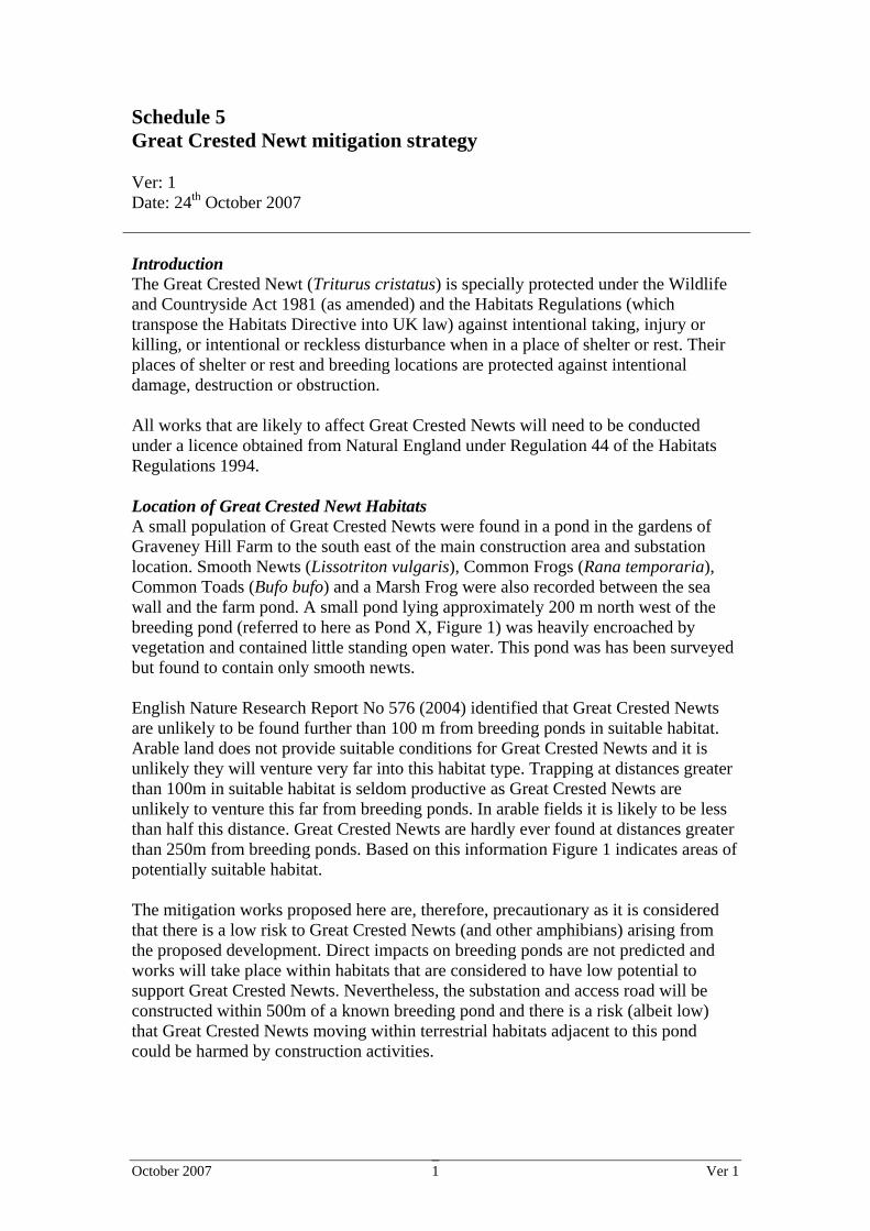
Schedule 5 Great Crested Newt mitigation strategy Ver: 1 Date: 24th October 2007 Introduction The Great Crested Newt (Triturus cristatus) is specially protected under the Wildlife and Countryside Act 1981 (as amended) and the Habitats Regulations (which transpose the Habitats Directive into UK law) against intentional taking, injury or killing, or intentional or reckless disturbance when in a place of shelter or rest. Their places of shelter or rest and breeding locations are protected against intentional damage, destruction or obstruction. All works that are likely to affect Great Crested Newts will need to be conducted under a licence obtained from Natural England under Regulation 44 of the Habitats Regulations 1994. Location of Great Crested Newt Habitats A small population of Great Crested Newts were found in a pond in the gardens of Graveney Hill Farm to the south east of the main construction area and substation location. Smooth Newts (Lissotriton vulgaris), Common Frogs (Rana temporaria), Common Toads (Bufo bufo) and a Marsh Frog were also recorded between the sea wall and the farm pond. A small pond lying approximately 200 m north west of the breeding pond (referred to here as Pond X, Figure 1) was heavily encroached by vegetation and contained little standing open water. This pond was has been surveyed but found to contain only smooth newts. English Nature Research Report No 576 (2004) identified that Great Crested Newts are unlikely to be found further than 100 m from breeding ponds in suitable habitat. Arable land does not provide suitable conditions for Great Crested Newts and it is unlikely they will venture very far into this habitat type. Trapping at distances greater than 100m in suitable habitat is seldom productive as Great Crested Newts are unlikely to venture this far from breeding ponds. In arable fields it is likely to be less than half this distance. Great Crested Newts are hardly ever found at distances greater than 250m from breeding ponds. Based on this information Figure 1 indicates areas of potentially suitable habitat. The mitigation works proposed here are, therefore, precautionary as it is considered that there is a low risk to Great Crested Newts (and other amphibians) arising from the proposed development. Direct impacts on breeding ponds are not predicted and works will take place within habitats that are considered to have low potential to support Great Crested Newts. Nevertheless, the substation and access road will be constructed within 500m of a known breeding pond and there is a risk (albeit low) that Great Crested Newts moving within terrestrial habitats adjacent to this pond could be harmed by construction activities.
October 2007 Ver 1 2
Figure 1. Graveney Hill Farm pond and areas of potentially suitable Great Crested Newt habitat. See key below
Pond X
Key:
Land within 50m of Graveney Hill Farm pond Potentially suitable terrestrial habitat for Great Crested Newts within 250m of Graveney Hill Farm pond
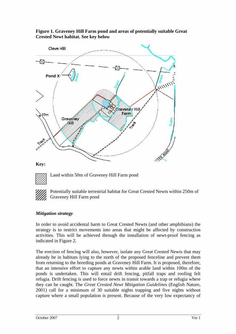
Mitigation strategy In order to avoid accidental harm to Great Crested Newts (and other amphibians) the strategy is to restrict movements into areas that might be affected by construction activities. This will be achieved through the installation of newt-proof fencing as indicated in Figure 2. The erection of fencing will also, however, isolate any Great Crested Newts that may already be in habitats lying to the north of the proposed fenceline and prevent them from returning to the breeding ponds at Graveney Hill Farm. It is proposed, therefore, that an intensive effort to capture any newts within arable land within 100m of the ponds is undertaken. This will entail drift fencing, pitfall traps and roofing felt refugia. Drift fencing is used to force newts in transit towards a trap or refugia where they can be caught. The Great Crested Newt Mitigation Guidelines (English Nature, 2001) call for a minimum of 30 suitable nights trapping and five nights without capture where a small population is present. Because of the very low expectancy of

October 2007 Ver 1 3
Great Crested Newts in the arable field, it is considered unlikely that trapping will need to extend beyond 30 days. Any newts captured will be relocated to terrestrial habitat adjacent to the breeding pond within the fenceline. It is unlikely that any Great Crested Newts will be caught in aquatic habitat. Any other amphibians caught during trapping or found during hand searches will also be relocated to suitable habitat. The exception is Marsh Frog (Rana ridibunda) which was recorded in the borrow pits near the sea wall. As it would be an offence to release this alien species into the wild, any caught will be handed to the project ecologist for identification and appropriate disposal. Figure 2. Proposed location of newt proof fencing and areas within which trapping and searching will take place
Pond X
Key:
Position of newt-proof fencing
Land within 100m of Graveney Hill Farm pond within which drift-nets, pit-fall traps and refugia will be established
Land within 250m Graveney Hill Farm pond within which destructive searching will be undertaken where construction activities are proposed
Following the completion of intensive trapping and the erection of the fencing, destructive searches will be undertaken only in those areas likely to be affected by

October 2007 Ver 1 4
construction activities that lie within 100-250m of Graveney Hill Farm pond. These searches will be undertaken prior to the commencement of construction activities and any amphibians found (except Marsh Frogs) will be relocated to land adjacent to Graveney Hill Farm, within the newt-proof fenceline. Newt-proof fencing will be left in place during construction activities and periodically checked to ensure its integrity. All of the works involving fence installation, trapping and searching will be undertaken under appropriate licence and supervised by a suitably qualified ecologist named in that licence. Key tasks and their expected timing are summarised in Table 1. Table 1. Great Crested Newt mitigation tasks Task Expected
duration Anticipated timing1
Destructive hand searches2 of areas affected by National Grid access route and over head line works
As required October – December 2007
Hand search along fenceline prior to vegetation clearance
2 days Immediately prior to installation of newt fencing
Installation of newt-proof fencing to 250m of breeding pond under ecological supervision
4 days February – April 2008
Installation of drift fencing , pitfall traps and artificial refugia to within 100 m of breeding pond under ecological supervision in area likely to be used by Great Crested Newts
6 days February – April 2008
Check traps and refugia 30 days3 April – June 2008 Removal of drift fencing, pitfall traps and refugia under ecological supervision
2 days After newt clearance
Destructive search2 during soil stripping within fenced area out to 250m
As required After newt clearance
Enhancement of Pond X. Work to include dredging and macrophyte clearance and creation of surrounding habitat
During landscaping works and after newt clearance
Supervision of newt fencing removal On completion of all works
Notes: 1 – The timeframe indicated in this table is based on LAL’s current programme which anticipates commencement of substation construction in Autumn 2008. If the construction programme changes the timing of these works will be reviewed.
2 – Destructive searching involves the careful removal of vegetation and other habitat features under the supervision of an ecologist
3 – 30 nights of trapping is considered to be the minimum effort for a small population for Great Crested Newts. In this case it is considered that trapping beyond 30 nights is unlikely to be required.
October 2007 Ver 1 5
To provide an overall enhancement of the habitat of amphibians, Pond X (see Figure 1) will be improved through dredging of accumulated sediment and the clearance of excessive macrophyte growth. Monitoring The results of trapping during mitigation will be recorded and reported upon in accordance with licence requirements. As predicted impacts on Great Crested Newts are considered to be low (the habitats affected by the proposed works are of low quality and breeding habitats will not be directly affected) there is no need for ongoing monitoring once mitigation works are completed. Reporting The holder of the Great Crested Newt Licence will be required to report to Natural England. There is no need for additional reporting beyond this requirement.

October 2007 Ver 1 1
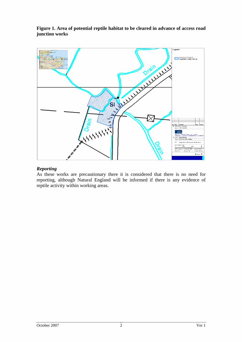
Schedule 6 Reptile habitat clearance and pre-construction surveys Ver: 1 Date: 18th October 2007 Introduction There is limited potential for reptiles at site, although it is assumed, as a precaution, that Slow-worm (Anguis fragilis), Grass Snake (Natrix natrix) and Common Lizard (Lacerta viridis) may be present, particularly in the vicinity of the proposed access road. All British reptile species are listed on Schedule 5 of the Wildlife and Countryside Act 1981, as updated by the Countryside and Rights of Way Act 2000. Slow Worm, Grass Snake and Common Lizard receive partial protection under part of Section 9(1) and all of Section 9(5). As such it is an offence to:
• intentionally kill or injure any individual; and • sell, offer for sale, possess or transport for the purpose of sale or publish
advertisements to buy or sell individual reptiles. On this basis it is proposed that any reptiles that may be present within working areas that are considered to comprise suitable habitat are excluded prior to construction, this can be achieved through appropriate vegetation management. Location of Reptile Habitats The only suitable areas for reptiles within the working area is the scrub, grassland and ruderal habitats near Seasalter Road where the junction for the access road is located. Reptiles are unlikely to frequent agricultural habitats. Mitigation Strategy As the area potentially affected is relatively small, mitigation for reptiles will be achieved by removing suitable vegetation from the construction area prior to the commencement of construction activities (See Figure 1). Prior to clearance areas of habitat affected will be searched by a suitably qualified ecologist for reptiles. Any found will be captured and relocated to suitable, nearby habitat. This should be conducted before frosts occur to allow them to move to shelter elsewhere before the temperature drops and hibernation begins. Once the vegetation is cut short it should be kept short until all works are completed and the access road constructed. Monitoring As these works are precautionary it is considered that there is no need for monitoring.
October 2007 Ver 1 2
Figure 1. Area of potential reptile habitat to be cleared in advance of access road junction works
Reporting As these works are precautionary there it is considered that there is no need for reporting, although Natural England will be informed if there is any evidence of reptile activity within working areas.

October 2007 Ver 1 1
Schedule 7 Pre-construction surveys for Water Voles Ver: 1 Date: 24th October 2007 Introduction No Water Voles were recorded on site despite a thorough survey for this species in August 2005 and subsequent amphibian surveys in April to May 2006 covering most of the drainage ditches across the site. It is highly likely that signs of Water Voles would have been recorded if the species were present. There are, however, recent records of Water Voles in the area and they could have moved into the ditches in the intervening period, especially given the higher than average rainfall in 2007. Water Vole burrows and places of shelter or rest are protected against damage, destruction or obstruction under Section 9(4) of the Wildlife and Countryside Act 1981 (as amended). Water Voles are protected against disturbance when in a place of shelter or rest. For these reasons a Water Vole survey will be conducted prior to commencement on site preferably in the optimum period (March to June inclusive). Location of Water Vole Habitats Habitats potentially suitable for Water Voles include borrow pits and wet drainage ditches. In addition to the borrow pits, four sections of drainage ditch would be affected by onshore cable works (see Figure 1). A culvert will be installed within a drainage channel near Seasalter Road to enable the access road to be constructed (also shown in Figure 1). Discussion with the Environment Agency has confirmed, however, that there is no further need for inspections of Water Voles within the drainage channel adjacent to Seasalter Road.

October 2007 Ver 1 2
Figure 1. Water Vole search area. Ditches potentially affected by construction activities are indicated in red. Additionally the banks of the borrow pits adjacent to the sea wall would also be inspected
Mitigation Strategy The banks of borrow pits and drainage ditches affected by cable installation will be checked thoroughly by a suitably qualified ecologist for the presence of Water Voles or signs of their presence, such as, for example, droppings, feeding remains and typical burrow systems. If Water Voles are found to be present, a mitigation plan will be prepared and agreed with the Environment Agency; Natural England will also be consulted. Mitigation for this species will be based on the Water Vole Conservation Handbook (Strachan & Moorhouse 2006) and is likely to include vole-proof fencing installed at appropriate locations and the area trapped until clear of voles. The optimum time for this is April and May in the season immediately preceding construction works. The alternative of vegetation clearance and soil scraping to encourage Water Voles out of burrows have been shown less effective due to burrow loyalty, and should only be used for short stretches of bank as a last resort (Strachan & Moorhouse 2006). Monitoring As these works are precautionary it is considered that there is no need for monitoring. If Water Voles are present monitoring may be required as part of any more detailed mitigation plan that is prepared. Reporting As these works are precautionary there it is considered that there is no need for reporting, although the Environment Agency will be informed if there is any evidence of Water Vole activity within working areas.
Cable route

October 2007 Ver 1 3
References Strachan, R. and Moorhouse, T. (2006). Water Vole Conservation Handbook. WILDCRU.