schedule 5 (motorcycle bays) - camden council
TRANSCRIPT
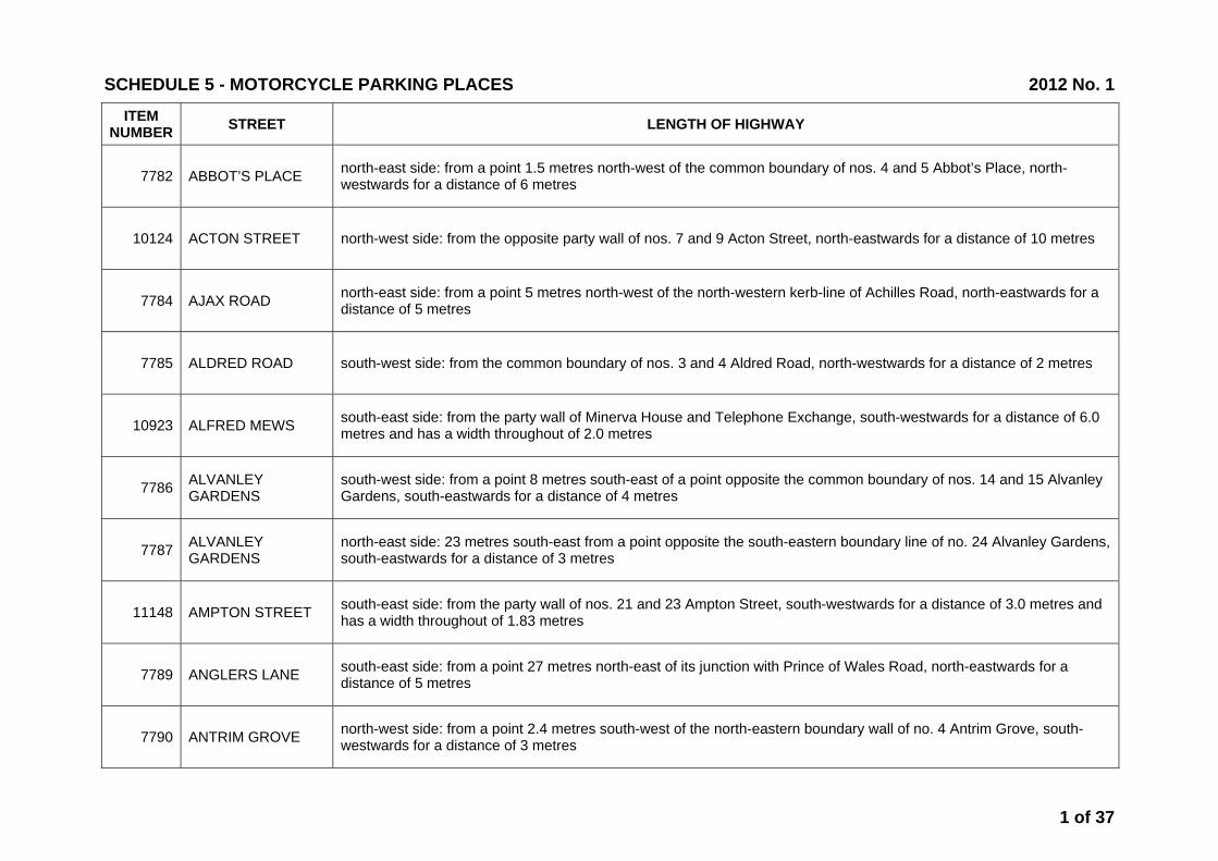
ITEM NUMBER STREET LENGTH OF HIGHWAY
7782 ABBOT’S PLACE north-east side: from a point 1.5 metres north-west of the common boundary of nos. 4 and 5 Abbot’s Place, north-westwards for a distance of 6 metres
10124 ACTON STREET north-west side: from the opposite party wall of nos. 7 and 9 Acton Street, north-eastwards for a distance of 10 metres
7784 AJAX ROAD north-east side: from a point 5 metres north-west of the north-western kerb-line of Achilles Road, north-eastwards for a distance of 5 metres
7785 ALDRED ROAD south-west side: from the common boundary of nos. 3 and 4 Aldred Road, north-westwards for a distance of 2 metres
10923 ALFRED MEWS south-east side: from the party wall of Minerva House and Telephone Exchange, south-westwards for a distance of 6.0 metres and has a width throughout of 2.0 metres
7786 ALVANLEY GARDENS
south-west side: from a point 8 metres south-east of a point opposite the common boundary of nos. 14 and 15 Alvanley Gardens, south-eastwards for a distance of 4 metres
7787 ALVANLEY GARDENS
north-east side: 23 metres south-east from a point opposite the south-eastern boundary line of no. 24 Alvanley Gardens, south-eastwards for a distance of 3 metres
11148 AMPTON STREET south-east side: from the party wall of nos. 21 and 23 Ampton Street, south-westwards for a distance of 3.0 metres and has a width throughout of 1.83 metres
7789 ANGLERS LANE south-east side: from a point 27 metres north-east of its junction with Prince of Wales Road, north-eastwards for a distance of 5 metres
7790 ANTRIM GROVE north-west side: from a point 2.4 metres south-west of the north-eastern boundary wall of no. 4 Antrim Grove, south-westwards for a distance of 3 metres
SCHEDULE 5 - MOTORCYCLE PARKING PLACES 2012 No. 1
1 of 37
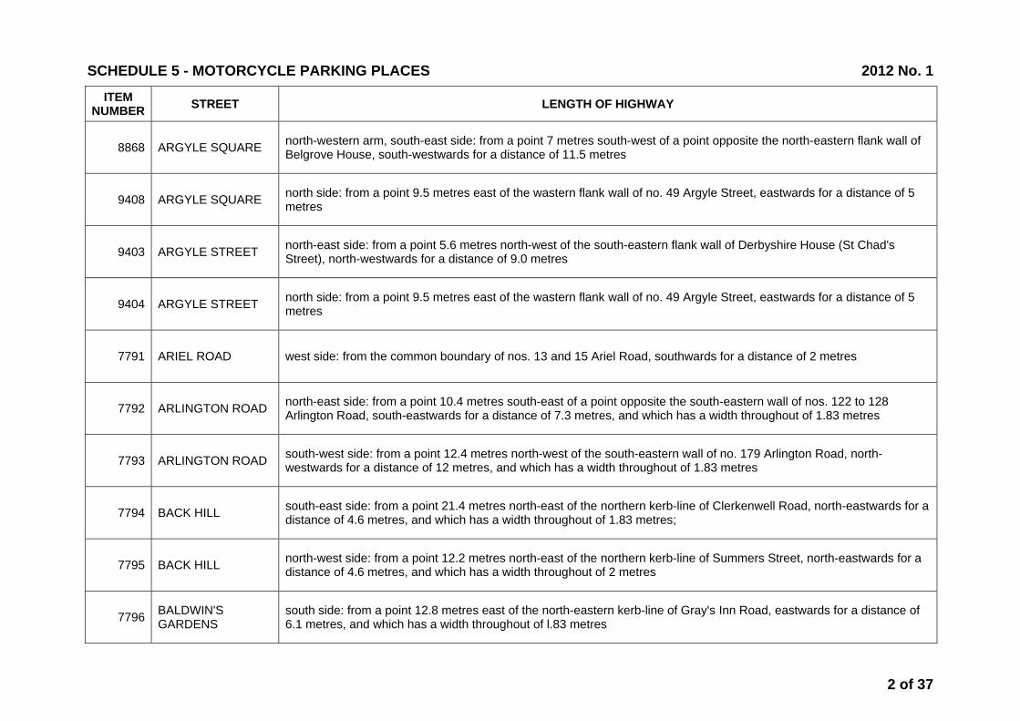
ITEM NUMBER STREET LENGTH OF HIGHWAY
8868 ARGYLE SQUARE north-western arm, south-east side: from a point 7 metres south-west of a point opposite the north-eastern flank wall of Belgrove House, south-westwards for a distance of 11.5 metres
9408 ARGYLE SQUARE north side: from a point 9.5 metres east of the wastern flank wall of no. 49 Argyle Street, eastwards for a distance of 5 metres
9403 ARGYLE STREET north-east side: from a point 5.6 metres north-west of the south-eastern flank wall of Derbyshire House (St Chad's Street), north-westwards for a distance of 9.0 metres
9404 ARGYLE STREET north side: from a point 9.5 metres east of the wastern flank wall of no. 49 Argyle Street, eastwards for a distance of 5 metres
7791 ARIEL ROAD west side: from the common boundary of nos. 13 and 15 Ariel Road, southwards for a distance of 2 metres
7792 ARLINGTON ROAD north-east side: from a point 10.4 metres south-east of a point opposite the south-eastern wall of nos. 122 to 128 Arlington Road, south-eastwards for a distance of 7.3 metres, and which has a width throughout of 1.83 metres
7793 ARLINGTON ROAD south-west side: from a point 12.4 metres north-west of the south-eastern wall of no. 179 Arlington Road, north-westwards for a distance of 12 metres, and which has a width throughout of 1.83 metres
7794 BACK HILL south-east side: from a point 21.4 metres north-east of the northern kerb-line of Clerkenwell Road, north-eastwards for a distance of 4.6 metres, and which has a width throughout of 1.83 metres;
7795 BACK HILL north-west side: from a point 12.2 metres north-east of the northern kerb-line of Summers Street, north-eastwards for a distance of 4.6 metres, and which has a width throughout of 2 metres
7796 BALDWIN'S GARDENS
south side: from a point 12.8 metres east of the north-eastern kerb-line of Gray's Inn Road, eastwards for a distance of 6.1 metres, and which has a width throughout of l.83 metres
SCHEDULE 5 - MOTORCYCLE PARKING PLACES 2012 No. 1
2 of 37
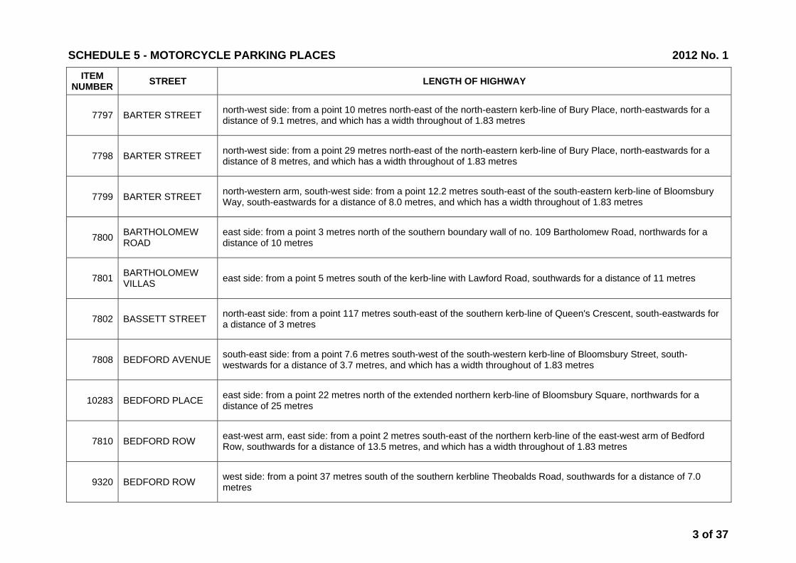
ITEM NUMBER STREET LENGTH OF HIGHWAY
7797 BARTER STREET north-west side: from a point 10 metres north-east of the north-eastern kerb-line of Bury Place, north-eastwards for a distance of 9.1 metres, and which has a width throughout of 1.83 metres
7798 BARTER STREET north-west side: from a point 29 metres north-east of the north-eastern kerb-line of Bury Place, north-eastwards for a distance of 8 metres, and which has a width throughout of 1.83 metres
7799 BARTER STREET north-western arm, south-west side: from a point 12.2 metres south-east of the south-eastern kerb-line of Bloomsbury Way, south-eastwards for a distance of 8.0 metres, and which has a width throughout of 1.83 metres
7800 BARTHOLOMEW ROAD
east side: from a point 3 metres north of the southern boundary wall of no. 109 Bartholomew Road, northwards for a distance of 10 metres
7801 BARTHOLOMEW VILLAS east side: from a point 5 metres south of the kerb-line with Lawford Road, southwards for a distance of 11 metres
7802 BASSETT STREET north-east side: from a point 117 metres south-east of the southern kerb-line of Queen's Crescent, south-eastwards for a distance of 3 metres
7808 BEDFORD AVENUE south-east side: from a point 7.6 metres south-west of the south-western kerb-line of Bloomsbury Street, south-westwards for a distance of 3.7 metres, and which has a width throughout of 1.83 metres
10283 BEDFORD PLACE east side: from a point 22 metres north of the extended northern kerb-line of Bloomsbury Square, northwards for a distance of 25 metres
7810 BEDFORD ROW east-west arm, east side: from a point 2 metres south-east of the northern kerb-line of the east-west arm of Bedford Row, southwards for a distance of 13.5 metres, and which has a width throughout of 1.83 metres
9320 BEDFORD ROW west side: from a point 37 metres south of the southern kerbline Theobalds Road, southwards for a distance of 7.0 metres
SCHEDULE 5 - MOTORCYCLE PARKING PLACES 2012 No. 1
3 of 37

ITEM NUMBER STREET LENGTH OF HIGHWAY
11668 BELMONT STREET west side: from a point 2.2 metres south of a point opposite the party wall of nos. 1 and 1A Belmont Street, northwards for a distance of 9.7 metres and which has a width throughout of 2.0 metres
7812 BELSIZE AVENUE south-east side: from a point 8 metres south-west of the common boundary wall of nos. 44 and 46 Belsize Avenue, south-westwards for a distance of 2 metres
7813 BELSIZE GROVE south-east side: from the north-east boundary wall of no. 42 Belsize Grove, south-westwards for a distance of 2.8 metres
7814 BELSIZE LANE north-west side: from a point 9 metres south-west of the south-western kerb-line of Belsize Crescent, south-westwards for a distance of 3.5 metres, and which has a width throughout of 1.8 metres
7815 BELSIZE PARK south-east side: from a point 2 metres south-west of the party wall of nos. 58 and 59 Belsize Park, south-westwards for a distance of 2.5 metres
9207 BELSIZE PARK north-east side: from a point 1 metres north-east of the party wall of nos. 48 and 47 Belsize Park, south-westwards for a distance of 4 metres
9640 BELSIZE PARK GARDENS
north-east side: from a point 1.0 metre north-west of the party wall of nos. 68 and 70 Belsize Park Gardens, north-westwards for a distance of 2.0 metres
7816 BELSIZE SQUARE north-eastern arm, north-east side: from a point 15 metres north-west of the party wall of nos. 49 and 50 Belsize Square, north-westwards for a distance of 2.5 metres
7817 BELSIZE SQUARE north-eastern arm, south-west side: from a point 2 metres south-east of a point opposite the common boundary wall of nos. 35 and 36 Belsize Square, south-eastwards for a distance of 2 metres
7818 BERKLEY ROAD west side: from a point 10 metres east of the south-eastern kerb-line of Regent's Park Road, southwards for a distance of 7 metres
SCHEDULE 5 - MOTORCYCLE PARKING PLACES 2012 No. 1
4 of 37
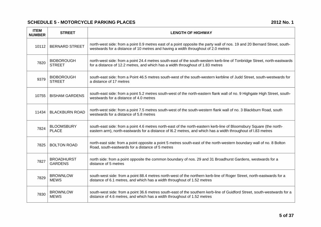
ITEM NUMBER STREET LENGTH OF HIGHWAY
10112 BERNARD STREET north-west side: from a point 0.9 metres east of a point opposite the party wall of nos. 19 and 20 Bernard Street, south-westwards for a distance of 10 metres and having a width throughout of 2.0 metres
7820 BIDBOROUGH STREET
north-west side: from a point 24.4 metres south-east of the south-western kerb-line of Tonbridge Street, north-eastwards for a distance of 12.2 metres, and which has a width throughout of 1.83 metres
9379 BIDBOROUGH STREET
south-east side: from a Point 46.5 metres south-west of the south-western kerbline of Judd Street, south-westwards for a distance of 17 metres
10755 BISHAM GARDENS south-east side: from a point 5.2 metres south-west of the north-eastern flank wall of no. 9 Highgate High Street, south-westwards for a distance of 4.0 metres
11434 BLACKBURN ROAD north-west side: from a point 7.5 metres south-west of the south-western flank wall of no. 3 Blackburn Road, south westwards for a distance of 5.8 metres
7824 BLOOMSBURY PLACE
south-east side: from a point 4.6 metres north-east of the north-eastern kerb-line of Bloomsbury Square (the north-eastern arm), north-eastwards for a distance of l6.2 metres, and which has a width throughout of l.83 metres
7825 BOLTON ROAD north-east side: from a point opposite a point 5 metres south-east of the north-western boundary wall of no. 8 Bolton Road, south-eastwards for a distance of 5 metres
7827 BROADHURST GARDENS
north side: from a point opposite the common boundary of nos. 29 and 31 Broadhurst Gardens, westwards for a distance of 5 metres
7829 BROWNLOW MEWS
south-west side: from a point 88.4 metres north-west of the northern kerb-line of Roger Street, north-eastwards for a distance of 6.1 metres, and which has a width throughout of 1.52 metres
7830 BROWNLOW MEWS
south-west side: from a point 36.6 metres south-east of the southern kerb-line of Guidford Street, south-westwards for a distance of 4.6 metres, and which has a width throughout of 1.52 metres
SCHEDULE 5 - MOTORCYCLE PARKING PLACES 2012 No. 1
5 of 37

ITEM NUMBER STREET LENGTH OF HIGHWAY
7831 BRUNSWICK SQUARE
north-western arm, south-east side: from a point 9.1 metres north-east of a point opposite the north-eastern boundary of no. 29 to 39 Brunswick Square, north-eastwards for a distance of 8 metres, and which has a width throughout of 1.83 metres
9708 BUCK STREET south side: form a point 12.1 metres for the western kerbline of Kentish Town Road, westwards for a distance of 8.8 metres
105 BURRARD ROAD north-west side: from a point 17 metres north-east of the north-eastern kerb-line of Fortune Green Road, north-eastwards for a distance of 4 metres
106 BURTON STREET north-east side: from a point 4.6 metres south-east of the south-easternmost point of Burton Place, south-eastwards for a distance of 4.6 metres, and which has a width throughout of 1.83 metres
107 CAMDEN SQUARE south-eastern arm, north-west side: from a point 67 metres north-east of its junction with Murray Street, south-westwards for a distance of 7 metres
108 CANTELOWES ROAD from the closure at its Camden Road end, south-eastwards for a distance of 2.5 metres for the entire width of the road.
10210 CAPPER STREET south-east side: from a point 16.5 meters north-east of the north-eastern kerb-line of Tottenham Court Road, north-eastwards for a distance of 5 meters.
11297 CAROL STREET north-west to south-east arm, south-west side: from a point 5.5 metres south-east of the southern kerb line of Greenland Road, south-eastwards for a distance of 8.5 metres and which has a width throughout of 1.83 metres
9364 CARTWRIGHT GARDENS
north-eastern arm, north-east side: from a point 29.8 metres south-east of the south-eastern kerb-line of Hastings Street, south-eastwards for a distance of 17.8 metres
11655 CARTWRIGHT GARDENS
north-eastern arm, north-east side: from a point 28.0 metres north-west of the north-western kerb-line of Leigh Street, north-westwards for a distance of 16.0 metres and which has a widththroughout of 1.83 metres
SCHEDULE 5 - MOTORCYCLE PARKING PLACES 2012 No. 1
6 of 37

ITEM NUMBER STREET LENGTH OF HIGHWAY
11263 CASTLE ROAD north side: from a point 1.5 metres east of the party wall of no.2 Castle Road and r/o 149 Kentish Town Road, eastwards for a distance of 2.0 metres and has a width throughout of 1.83 metres
12285 CASTLEHAVEN ROAD
north-west side: from a point 3.0 metres north-east of the north-eastern kerb line of The Arches, north-eastwards for a distance of 6.0 metres and having a width throughout of 1.83 metres
113 CHALTON STREET north-east to south-west arm, north-west side: from a point 3.1 metres south-west of the south-western kerb-line of Goldington Crescent, south-westwards for a distance of 8.5 metres, and which has a width throughout of 1.83 metres
115 CHARLOTTE MEWS
south-west side: from a point 1.5 metres north-west of a point opposite the party wall of nos. 5 and 6 Charlotte Mews, south-eastwards for a distance of 7.6 metres, and which has a width throughout of 1.83 metres
10295 CHARLOTTE STREET
north-east side: from the common boundary of nos. 16 and 18 Charlotte Street, south-eastwards for a distance of 6 metres
10305 CHARLOTTE STREET
south-west side: from the common boundary of nos. 61 and 63 Charlotte Street, south-eastwards for a distance of 9 metres
11518 CHARLOTTE STREET
north-east side: from a point 11.10 metres south-east of the south-eastern kerb line of Howland Street, south-eastwards for a distance of 7.10 metres, and which has a width throughout of 1.83 metres
10356 CHENIES STREET south-east side: from a point 9.0 metres south-west of the south-western kerb-line of Alfred Place, south-westwards for a distance of 19 metres
9242 CHESTERFORD GARDENS
west-side: from a point 6 metres south of the southern kerb-line of Redington Road, southwards for a distance of 4 metres
10309 CHITTY STREET the south-east side from a point 41.5 metres north-east of the north-eastern kerb line of Charlotte Street, north-eastwards for a distance of 5.8 metres
SCHEDULE 5 - MOTORCYCLE PARKING PLACES 2012 No. 1
7 of 37

ITEM NUMBER STREET LENGTH OF HIGHWAY
119 CLEVELAND STREET
north-east side: from a point 6.1 metres south-east of the southern kerb-line of Warren Street, south-eastwards for a distance of 6.1 metres, and which has a width throughout of 2.13 metres
9503 COLEY STREET south-east side: from a point 18.0 metres north-east of the north-eastern kerb-line of Gray’s Inn Road, north-eastwards for a distance of 5.0 metres
120 COLLEGE PLACE west side: from a point opposite the boundary wall of nos. 101/103 College Place, southwards for a distance of 9.5 metres
9202 CONSTANTINE ROAD
south-east side: from a a point 1.2 metres south-west of the party wall of nos. 4 and 6 Constantine Road, south-west for a distance of 3 metres
10925 CONSTANTINE ROAD
the north side from the common boundary wall of Nos.41 and 43 Constantine Road, north-eastwards for a distance of 4.3 metres and has a width throughout of 2.0 metres
121 COTLEIGH ROAD north side: from a point 10 metres east of the eastern boundary of no. 2 Cotleigh Road, eastwards for a distance of 6 metres
122 COURTHOPE ROAD
south-west side: from a point 1.2 metres south-east of the party wall of nos.29 and 31 Courthope Road, south-eastwards for a distance of 2.9 metres
9197 COURTHOPE ROAD
north-west side: from a point 3.2 metres south-east of the south-eastern kerbline of Savernake Road, south-eastwards for a distance of 4.0 metres
124 CREDITON HILL west side: from a point 16 metres south of the south-eastern kerb-line of West End Lane, southwards for a distance of 3 metres
12060 CRESTFIELD STREET
north-east side: from a point 19.2 metres south-east of a point in line with the north-western building line of Nos. 1 to 11 Euston Road, south-eastwards for a distance of 16 metres and which has a width throughout of 2.0 metres
SCHEDULE 5 - MOTORCYCLE PARKING PLACES 2012 No. 1
8 of 37
ITEM NUMBER STREET LENGTH OF HIGHWAY
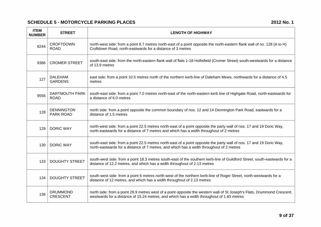
8244 CROFTDOWN ROAD
north-west side: from a point 8.7 metres north-east of a point opposite the north-eastern flank wall of no. 128 (A to H) Croftdown Road, north-eastwards for a distance of 3 metres
9386 CROMER STREET south-east side: from the north-eastern flank wall of flats 1-18 Hollisfield (Cromer Street) south-westwards for a distance of 13.9 metres
127 DALEHAM GARDENS
east side: from a point 10.5 metres north of the northern kerb-line of Daleham Mews, northwards for a distance of 4.5 metres
9556 DARTMOUTH PARK ROAD
south-east side: from a point 7.0 metres north-east of the north-eastern kerb line of Highgate Road, north-eastwards for a distance of 6.0 metres
128 DENNINGTON PARK ROAD
north side: from a point opposite the common boundary of nos. 12 and 14 Dennington Park Road, eastwards for a distance of 1.5 metres
129 DORIC WAY north-west side: from a point 22.5 metres north-east of a point opposite the party wall of nos. 17 and 19 Doric Way, north-eastwards for a distance of 7 metres and which has a width throughout of 2 metres
130 DORIC WAY south-east side: from a point 22.5 metres north-east of a point opposite the party wall of nos. 17 and 19 Doric Way, north-eastwards for a distance of 7 metres, and which has a width throughout of 2 metres
133 DOUGHTY STREET south-west side: from a point 18.3 metres south-east of the southern kerb-line of Guildford Street, south-eastwards for a distance of 12.2 metres, and which has a width throughout of 2.13 metres
134 DOUGHTY STREET south-west side: from a point 6 metres north-west of the northern kerb-line of Roger Street, north-westwards for a distance of 12 metres, and which has a width throughout of 2.13 metres
136 DRUMMOND CRESCENT
north side: from a point 29.9 metres west of a point opposite the western wall of St Joseph's Flats, Drummond Crescent, westwards for a distance of 15.24 metres, and which has a width throughout of 1.83 metres
SCHEDULE 5 - MOTORCYCLE PARKING PLACES 2012 No. 1
9 of 37

ITEM NUMBER STREET LENGTH OF HIGHWAY
135 DRUMMOND STREET
south-east side: from a point 26.8 metres south-west of the south-western kerb-line of Melton Street, south-westwards for a distance of 7.6 metres, and which has a width throughout of 1.83 metres
9357 DUKE'S ROAD north-east side: from a point 8.3 metres south-east of the party wall of nos. 1-10 and 22 Duke’s Road, south-eastwards for a distance of 5.0 metres
7832 DUMPTON PLACE west side: from a point 8 metres north of the northern kerb-line of Gloucester Avenue, northwards for a distance of 10 metres
7834 EARLHAM STREET north-west side: from a point of 21.9 metres north-east of the north-eastern kerb line of Tower Street, north-eastwards for a distance of 12.2 metres, and which has a width throughout of 1.83 metres
7835 ELSWORTHY ROAD north side: from a point opposite the party wall of no. 32 and 34 Elsworthy Road, eastwards for a distance of 3 metres
7838 ENDELL STREET south-west side: from a point 3.7 metres south-east of the south-eastern kerb-line of High Holborn, south-eastwards for a distance of 13.7 metres, and which has a width of 6.1 metres commencing at the north-western at the end decreasing to 1.52 metres
11428 ENDELL STREET south-west side: from a point 13.4 metres south-east of the south-eastern kerb-line of Princes Circus, south-eastwards for a distance of 12.6 metres, and which has a width throughout of 1.83 metres
10253 ENDSLEIGH STREET
north-east side: from a point 11.2 metres south-east of the south-eastern kerb-line of Endsleigh Gardens, south-eastwards for a distance of 10 metres
7839 ENGLAND'S LANE south-east side: from the south-western most flank wall of no. 39 England's Lane, north-eastwards for a distance of 8 metres, and which has a width throughout of 1 metre.
7840 ESTELLE ROAD south-west side: from a point 1 metre south-east of the north-western boundary wall of no. 43 Estelle Road, north-westwards for a distance of 3.0 metres
SCHEDULE 5 - MOTORCYCLE PARKING PLACES 2012 No. 1
10 of 37

ITEM NUMBER STREET LENGTH OF HIGHWAY
10903 ETON AVENUE north-west side: from a point 5.4 metres east of the eastern boundary wall of the Embassy Theatre, eastwards for a distance of 4.0 metres and has a width throughout of 2.0 metres
7842 ETON ROAD south-east side: from a point 8.5 metres north-east of the north-eastern kerb-line of Eton Villas, north-eastwards for a distance of 2.5 metres
7843 ETON VILLAS north-east side: from a point 3.6 metres south-east the party wall of nos. 19 and 20 Eton Villas, north-westwards for a distance of 2.5 metres
7844 EUSTON STREET south side: from a point 1.8 metres south-west of the south-western kerb-line of Regnart Buildings, south-westwards for a distance of 7 metres
7845 EYRE STREET HILL east side: from a point 4.6 metres north of the northern kerb-line of Summers Street, northwards for a distance of 4.6 metres, and which has a width throughout of 1.83 metres
7846 FAIRHAZEL GARDENS
south-west side: from the common boundary of nos. 45 and 47 Fairhazel Gardens, north-westwards for a distance of 5 metres
11264 FALKLAND ROAD south side: from a point 12.8 metres east of the eastern kerb line of Fortess Road, eastwards for a distance of 2.0 metres and has a width throughout of 1.83 metres
7847 FAWLEY ROAD north side: from a point 10 metres east of the eastern kerb-line of West End Lane, eastwards for a distance of 5 metres
7848 FELLOWS ROAD south side: from a point 31 metres west of the eastern flank wall of Higginson House, westwards for a distance of 2.5 metres
7849 FELLOWS ROAD south side: from a point 1.25 metres west of a point opposite the party wall of nos. 140 and 142 Fellows Road, westwards for a distance of 3 metres
SCHEDULE 5 - MOTORCYCLE PARKING PLACES 2012 No. 1
11 of 37

ITEM NUMBER STREET LENGTH OF HIGHWAY
7850 FELLOWS ROAD south side: from a point 2.5 metres east of the party wall of nos. 85 and 87 Fellows Road, eastwards for a distance of 4 metres
11670 FERDINAND PLACE west side: from a point level with the southern flank wall of no. 1 Ferdinand Place, northwards for a distance of 4.0 metres and which has a width throughout of 2.0 metres
7851 FIELD STREET the west side of the railway lines at the cul-de-sac end: from a point 9.5 metres east of the junction with Wicklow Street and parallel to the railway boundary wall for a distance of 4.3 metres between the north and south kerb-lines of Field Street.
12107 FITZROY ROAD south-east side: from a point 13.7 metres south-west of the south-western kerb-line of Chalcot Road, south-westwards for a distance of 6.2 metres and which has a width throughout of 2.0 metres
7854 FITZROY STREET north-east side: from a point 1.5 metres north-west of the north-western kerb-line of Fitzroy Square, north-westwards for a distance of 12.2 metres, and which has a width throughout of 1.83 metres
11519 FITZROY STREET south-west side: from a point 18.70 metres north-west of the north-western kerb line of Howland Street, north-westwards for a distance of 14.0 metres, and which has a width throughout of 1.83 metres
12229 FITZROY STREET north-east side from a point 14.10 metres south-east of the south eastern kerb line of Euston Road, south eastwards for a distance of 16.0 metres and having a width throughout of 2.0 metres
7855 FLASK WALK north-west side: from a point 3.5 metres north-east of the north-eastern kerb-line of Back Lane, north-eastwards for a distance of 4.5 metres
9361 FLAXMAN TERRACE
south-east side: from a pont 5.9 metres north-east of the north-eastern kerbline Burton Street, north-eastwards for a distance of 7.5 metres
9593 FLAXMAN TERRACE
south-east side: from a point 1.3 metres south-west of the party wall of nos. 1-18 and 19-42 Flaxman Court, Flaxman Terrace, north-eastwards for a distance of 5.0 metres
SCHEDULE 5 - MOTORCYCLE PARKING PLACES 2012 No. 1
12 of 37
ITEM NUMBER STREET LENGTH OF HIGHWAY
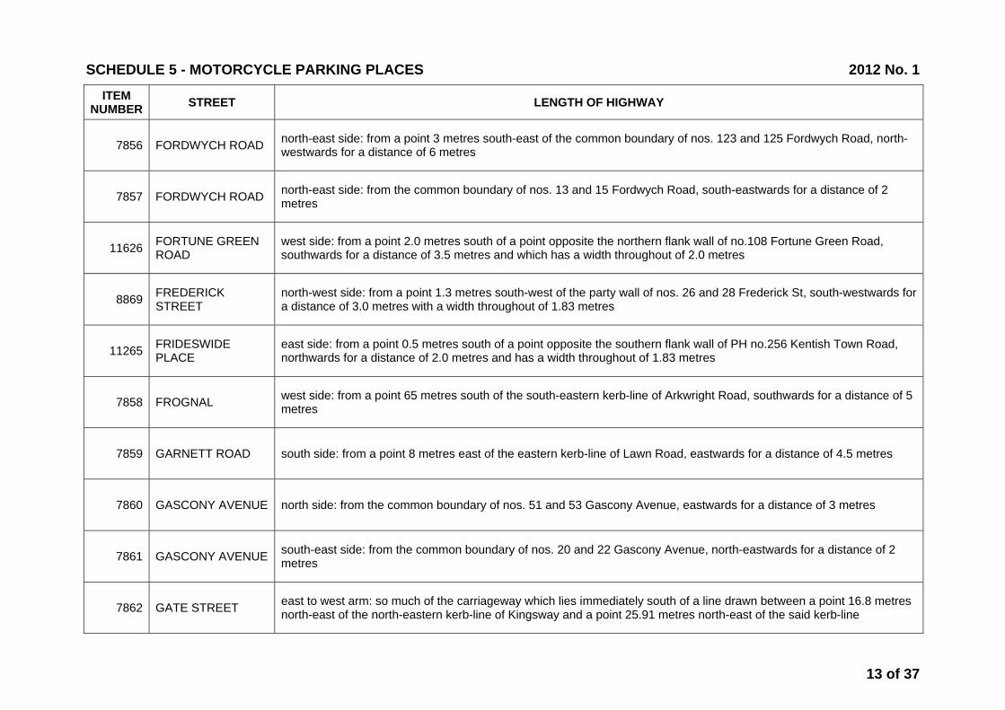
7856 FORDWYCH ROAD north-east side: from a point 3 metres south-east of the common boundary of nos. 123 and 125 Fordwych Road, north-westwards for a distance of 6 metres
7857 FORDWYCH ROAD north-east side: from the common boundary of nos. 13 and 15 Fordwych Road, south-eastwards for a distance of 2 metres
11626 FORTUNE GREEN ROAD
west side: from a point 2.0 metres south of a point opposite the northern flank wall of no.108 Fortune Green Road, southwards for a distance of 3.5 metres and which has a width throughout of 2.0 metres
8869 FREDERICK STREET
north-west side: from a point 1.3 metres south-west of the party wall of nos. 26 and 28 Frederick St, south-westwards for a distance of 3.0 metres with a width throughout of 1.83 metres
11265 FRIDESWIDE PLACE
east side: from a point 0.5 metres south of a point opposite the southern flank wall of PH no.256 Kentish Town Road, northwards for a distance of 2.0 metres and has a width throughout of 1.83 metres
7858 FROGNAL west side: from a point 65 metres south of the south-eastern kerb-line of Arkwright Road, southwards for a distance of 5 metres
7859 GARNETT ROAD south side: from a point 8 metres east of the eastern kerb-line of Lawn Road, eastwards for a distance of 4.5 metres
7860 GASCONY AVENUE north side: from the common boundary of nos. 51 and 53 Gascony Avenue, eastwards for a distance of 3 metres
7861 GASCONY AVENUE south-east side: from the common boundary of nos. 20 and 22 Gascony Avenue, north-eastwards for a distance of 2 metres
7862 GATE STREET east to west arm: so much of the carriageway which lies immediately south of a line drawn between a point 16.8 metres north-east of the north-eastern kerb-line of Kingsway and a point 25.91 metres north-east of the said kerb-line
SCHEDULE 5 - MOTORCYCLE PARKING PLACES 2012 No. 1
13 of 37

ITEM NUMBER STREET LENGTH OF HIGHWAY
10435 GLENBROOK ROAD
south side: from a point 4.5 metres east of the eastern kerb line of Sumatra Road, eastwards for a distance of 3.0 metres and has a width throughout of 2.0 metres
7865 GLENILLA ROAD south-west side: from a point 0.5 metres north-west of the boundary wall of nos. 28 and 28a Glenilla Road, north-westwards for a distance of 2.5 metres
7866 GLOUCESTER AVENUE
west side: from a point 2.7 metres north of a point opposite the party wall of nos. 148 and 150 Gloucester Avenue, southwards for a distance of 4.1 metres
7868 GONDAR GARDENS south side: from the party wall of nos. 54 and 56 Gondar Gardens, westwards for a distance of 2 metres
7869 GONDAR GARDENS
south side: outside Pine Mansions from a point 4 metres east of the eastern kerb-line of the western arm of Gondar Gardens, eastwards for a distance of 2 metres
7870 GOODGE PLACE north-west and north-east side:from a point 9.1 metres north-east of the north-eastern kerb-line of Goodge Place, north-eastwards and then south-eastwards for a distance of 8.2 metres, and which has a width throughout of 2.13 metres
7871 GORDON SQUARE north-eastern arm, south-west side: from a point 2.4 metres north-west of a point opposite the party wall of nos. 36 and 37 Gordon Square, north-westwards for a distance of 9.1 metres, and which has a width throughout of 2.13 metres
7872 GORDON SQUARE north-eastern arm, south-west side: from a point 300 millimetres south-east of a point opposite the party wall of nos. 52 and 53 Gordon Square, south-eastwards for a distance of 6.1 metres, and which has a width throughout of 2.13 metres
10259 GORDON SQUARE south-western arm, north-east side:from a point 2.3 metres south-east of a point opposite the party wall of nos. 21 and 22 Gordon Square, north-eastwards for a distance of 16.6 metres, and which has a width throughout of 2.13 metres
7874 GOUGH STREET north-east side: from a point 20 metres south-east of the south-east kerb-line of Coley Street, north-westwards for a distance of 13.6 metres
SCHEDULE 5 - MOTORCYCLE PARKING PLACES 2012 No. 1
14 of 37
ITEM NUMBER STREET LENGTH OF HIGHWAY
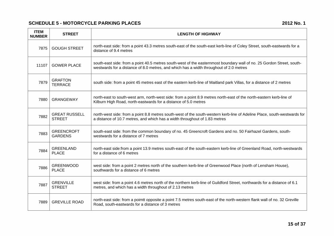
7875 GOUGH STREET north-east side: from a point 43.3 metres south-east of the south-east kerb-line of Coley Street, south-eastwards for a distance of 9.4 metres
11107 GOWER PLACE south-east side: from a point 40.5 metres south-west of the easternmost boundary wall of no. 25 Gordon Street, south-westwards for a distance of 8.0 metres, and which has a width throughout of 2.0 metres
7879 GRAFTON TERRACE south side: from a point 45 metres east of the eastern kerb-line of Maitland park Villas, for a distance of 2 metres
7880 GRANGEWAY north-east to south-west arm, north-west side: from a point 8.9 metres north-east of the north-eastern kerb-line of Kilburn High Road, north-eastwards for a distance of 5.0 metres
7882 GREAT RUSSELL STREET
north-west side: from a point 8.8 metres south-west of the south-western kerb-line of Adeline Place, south-westwards for a distance of 10.7 metres, and which has a width throughout of 1.83 metres
7883 GREENCROFT GARDENS
south-east side: from the common boundary of no. 45 Greencroft Gardens and no. 50 Fairhazel Gardens, south-westwards for a distance of 7 metres
7884 GREENLAND PLACE
north-east side:from a point 13.9 metres south-east of the south-eastern kerb-line of Greenland Road, north-westwards for a distance of 6 metres
7886 GREENWOOD PLACE
west side: from a point 2 metres north of the southern kerb-line of Greenwood Place (north of Lensham House), southwards for a distance of 6 metres
7887 GRENVILLE STREET
west side: from a point 4.6 metres north of the northern kerb-line of Guildford Street, northwards for a distance of 6.1 metres, and which has a width throughout of 2.13 metres
7889 GREVILLE ROAD north-east side: from a poimtt opposite a point 7.5 metres south-east of the north-western flank wall of no. 32 Greville Road, south-eastwards for a distance of 3 metres
SCHEDULE 5 - MOTORCYCLE PARKING PLACES 2012 No. 1
15 of 37
ITEM NUMBER STREET LENGTH OF HIGHWAY
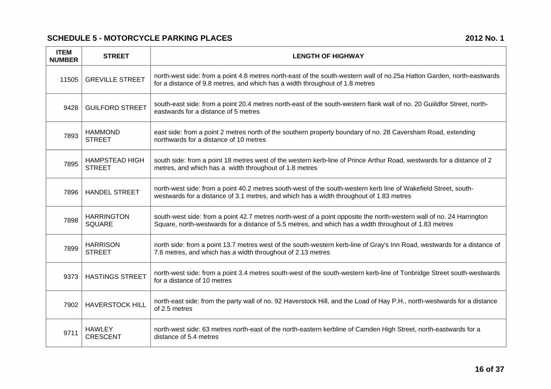
11505 GREVILLE STREET north-west side: from a point 4.8 metres north-east of the south-western wall of no.25a Hatton Garden, north-eastwards for a distance of 9.8 metres, and which has a width throughout of 1.8 metres
9428 GUILFORD STREET south-east side: from a point 20.4 metres north-east of the south-western flank wall of no. 20 Guiildfor Street, north-eastwards for a distance of 5 metres
7893 HAMMOND STREET
east side: from a point 2 metres north of the southern property boundary of no. 28 Caversham Road, extending northwards for a distance of 10 metres
7895 HAMPSTEAD HIGH STREET
south side: from a point 18 metres west of the western kerb-line of Prince Arthur Road, westwards for a distance of 2 metres, and which has a width throughout of 1.8 metres
7896 HANDEL STREET north-west side: from a point 40.2 metres south-west of the south-western kerb line of Wakefield Street, south-westwards for a distance of 3.1 metres, and which has a width throughout of 1.83 metres
7898 HARRINGTON SQUARE
south-west side: from a point 42.7 metres north-west of a point opposite the north-western wall of no. 24 Harrington Square, north-westwards for a distance of 5.5 metres, and which has a width throughout of 1.83 metres
7899 HARRISON STREET
north side: from a point 13.7 metres west of the south-western kerb-line of Gray's Inn Road, westwards for a distance of 7.6 metres, and which has a width throughout of 2.13 metres
9373 HASTINGS STREET north-west side: from a point 3.4 metres south-west of the south-western kerb-line of Tonbridge Street south-westwards for a distance of 10 metres
7902 HAVERSTOCK HILL north-east side: from the party wall of no. 92 Haverstock Hill, and the Load of Hay P.H., north-westwards for a distance of 2.5 metres
9711 HAWLEY CRESCENT
north-west side: 63 metres north-east of the north-eastern kerbline of Camden High Street, north-eastwards for a distance of 5.4 metres
SCHEDULE 5 - MOTORCYCLE PARKING PLACES 2012 No. 1
16 of 37
ITEM NUMBER STREET LENGTH OF HIGHWAY
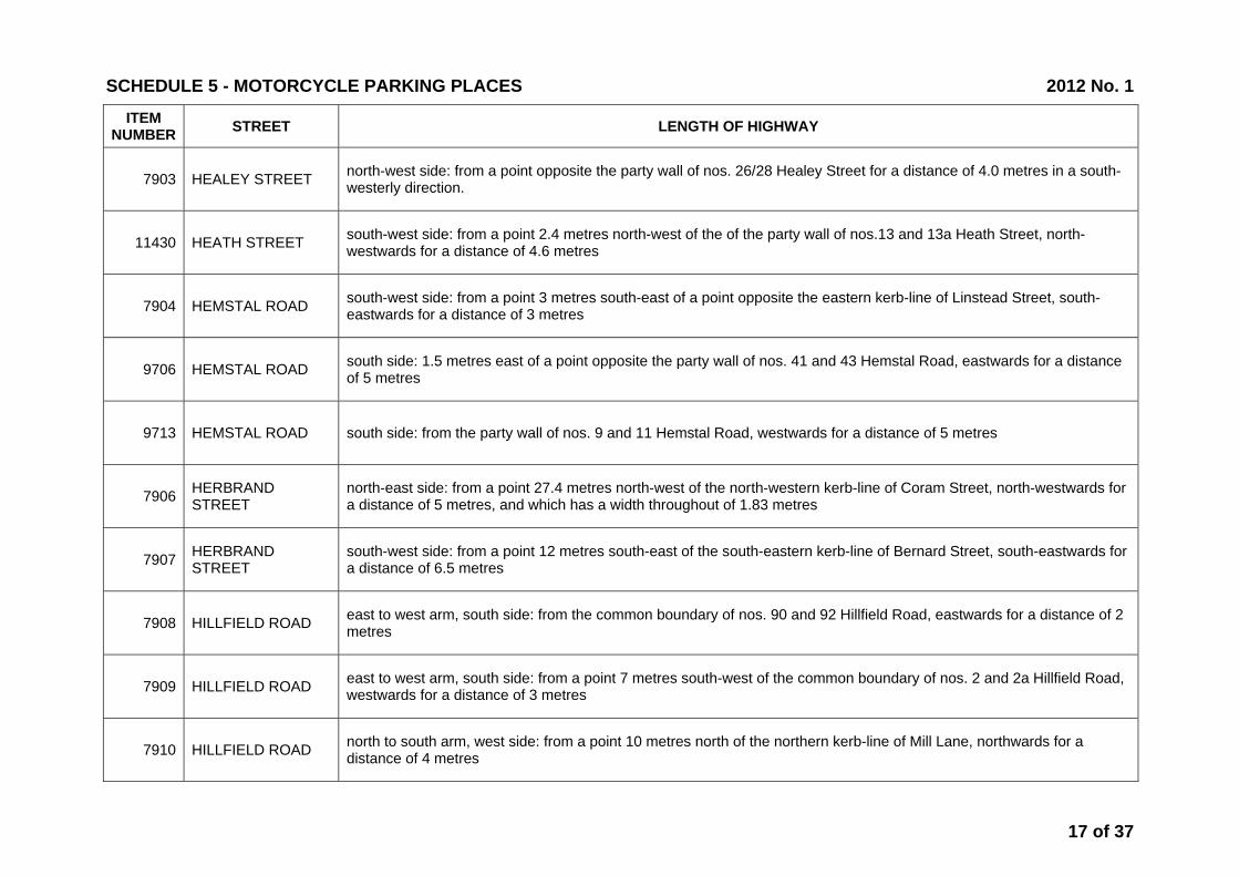
7903 HEALEY STREET north-west side: from a point opposite the party wall of nos. 26/28 Healey Street for a distance of 4.0 metres in a south-westerly direction.
11430 HEATH STREET south-west side: from a point 2.4 metres north-west of the of the party wall of nos.13 and 13a Heath Street, north-westwards for a distance of 4.6 metres
7904 HEMSTAL ROAD south-west side: from a point 3 metres south-east of a point opposite the eastern kerb-line of Linstead Street, south-eastwards for a distance of 3 metres
9706 HEMSTAL ROAD south side: 1.5 metres east of a point opposite the party wall of nos. 41 and 43 Hemstal Road, eastwards for a distance of 5 metres
9713 HEMSTAL ROAD south side: from the party wall of nos. 9 and 11 Hemstal Road, westwards for a distance of 5 metres
7906 HERBRAND STREET
north-east side: from a point 27.4 metres north-west of the north-western kerb-line of Coram Street, north-westwards for a distance of 5 metres, and which has a width throughout of 1.83 metres
7907 HERBRAND STREET
south-west side: from a point 12 metres south-east of the south-eastern kerb-line of Bernard Street, south-eastwards for a distance of 6.5 metres
7908 HILLFIELD ROAD east to west arm, south side: from the common boundary of nos. 90 and 92 Hillfield Road, eastwards for a distance of 2 metres
7909 HILLFIELD ROAD east to west arm, south side: from a point 7 metres south-west of the common boundary of nos. 2 and 2a Hillfield Road, westwards for a distance of 3 metres
7910 HILLFIELD ROAD north to south arm, west side: from a point 10 metres north of the northern kerb-line of Mill Lane, northwards for a distance of 4 metres
SCHEDULE 5 - MOTORCYCLE PARKING PLACES 2012 No. 1
17 of 37

ITEM NUMBER STREET LENGTH OF HIGHWAY
9714 HILLFIELD ROAD east to west arm, south side: from a point 4.5 metres east of the eastern kerbline of Hillfield Road, eastwards for a distance of 2.5 metres
7911 HILLTOP ROAD west side: from the common boundary of nos. 14 and 16 Hilltop Road, southwards for a distance of 3 metres
7912 HOLMDALE ROAD north-east side: from the common boundary of nos. 9 and 11 Holmdale Road, south-eastwards for a distance of 2 metres
7913 HOLMDALE ROAD south-west side: from the common boundary of nos. 24 and 26 Holmdale Road, north-westwards for a distance of 2 metres
7914 HOLMDALE ROAD south-west side: from a point 5 metres north-west of the north-western kerb-line of Dennington Park Road, north-westwards for a distance of 2 metres
7915 HOLMES ROAD north-west side: from a point 53 metres north-east of its junction with Spring place, north-eastwards for a distance of 8 metres
7916 HONEYBOURNE ROAD
east side: from the common boundary of nos. 1-8 Yale Court, Honeybourne Road and no. 288a West End Lane, southwards for a distance of 2 metres
7917 HOWITT ROAD south-east side: from the south-western boundary wall of no. 57 Howitt Road, north-eastwards for a distance of 3 metres
11874 HOWLAND STREET north-west side: from a point 5.0 metres south-west of the south-western kerb-line of Whitfield Street and which has a width throughout of 2.0 metres
7918 HUNTLEY STREET north-east side: from a point 10.7 metres south-east of the south-eastern kerb-line of Torrington Place, south-eastwards for a distance of 4.6 metres, and which has a width throughout of 1.83 metres;
SCHEDULE 5 - MOTORCYCLE PARKING PLACES 2012 No. 1
18 of 37

ITEM NUMBER STREET LENGTH OF HIGHWAY
10211 HUNTLEY STREET north-east side: from a point 2.8 metres south-east of the north-western flank wall of no. 70 Huntley Street, south-eastwards for a distance of 9 metres
10436 INGLEWOOD ROAD south side: from a point 4.9 metres west of the western kerb line of West End Lane, westwards for a distance of 3.0 metres and has a width throughout of 2.0 metres
11266 ISLIP STREET north side: from a point 3.5 metres west of a point opposite the eastern flank wall of no.39 Islip Street, westwards for a distance of 4.0 metres and has a width throughout of 1.83 metres
7920 IVERSON ROAD south side: from the common boundary of nos. 142 and 144 Iverson Road, westwards for a distance of 5 metres
7921 JAMESTOWN ROAD
south-east side: from a point 48 metres south-west of the south-western kerb-line of Arlington Road, south-westwards for a distance of 4 metres, and which has a width throughout of 1.83 metres
7922 JOCKEY'S FIELDS north-east side: from a point 24.38 metres south-east of the south-eastern kerb-line of Theobald's Road, south-eastwards for a distance of 9.1 metres, and which has a width throughout of 1.83 metres
7923 JOHN STREET north-east side: from a point 6.1 metres south-east of the south-eastern kerb-lineof Northington Street, south-eastwards for a distance of 3.1 metres, and which has a width throughout of 1.83 metres
7924 JOHN STREET south-west side: from a point 8.9 metres south-east of the south-eastern kerb-lineof Northington Street, south-eastwards for a distance of 3.1 metres, and which has a width throughout of 1.83 metres
7925 JOHN'S MEWS south-west side: from a point 0.7 metres south-east of a point opposite the party wall of nos. 25 and 27 John’s Mews, south-eastwards for a distance of 7.0 metres
7926 KELLY STREET west side: (behind the eastern pavement of Castlehaven Road), from a point 9 metres north of the party wall of nos. 111 and 113 Castlehaven Road, northwards for a distance of 9 metres
SCHEDULE 5 - MOTORCYCLE PARKING PLACES 2012 No. 1
19 of 37

ITEM NUMBER STREET LENGTH OF HIGHWAY
7927 KILBURN PRIORY south-west side: from a point opposite a point 4 metres south-east of the north-west flank wall of nos. 1-8 Kilburn Gate, Kilburn Priory, south-eastwards for a distance of 5 metres
7928 KILBURN VALE north-east side: from a point 3.5 metres south-east of the north-western flank wall of the Public House, 250 Belsize Road, south-eastwards for a distance of 5 metres
7929 KINGDON ROAD north-west side: from the common boundary of nos. 11 and 13 Kingdon Road, north-eastwards for a distance of 3 metres
7930 KINGDON ROAD north-west side: from the common boundary of no. 1 Kingdon Road and nos. 14 to 20 Dene Mansions, Dennington Park Road, north-eastwards for a distance of 2 metres
7931 KINGS COLLEGE ROAD east side: from a point 5 metres north of the northern kerb-line of Fellows Road, northwards for a distance of 5.5 metres
7934 KINGSGATE ROAD east side: from a point 2 metres north of the northern kerb-line of Dynham Road, northwards for a distance of 8 metres
7935 KINGSGATE ROAD north-east side: from the party wall of nos. 79 and 81 Kingsgate Road, north-westwards for a distance of 5 metres
11829 KINGSGATE ROAD west side: from a point 2.6 metres south of a point opposite the party wall of nos. 41 and 43 Kingsgate Road, northwards for a distance of 3.5 metres and which has a width throughout of 2.0 metres
11830 KINGSGATE ROAD east side: from a point 1.5 metres south of the the party wall of nos. 37 and 39 Kingsgate Road, southwards for a distance of 3.0 metres and which has a width throughout of 2.0 metres
10921 KIRBY STREET south-west side: from a point 5.8 metres north-west of the common boundary of Nos.36-43 and 44-45 Kirby Street, north-westwards for a distance of 28.0 metres and having a width throughout of 2 metres
SCHEDULE 5 - MOTORCYCLE PARKING PLACES 2012 No. 1
20 of 37

ITEM NUMBER STREET LENGTH OF HIGHWAY
11506 KIRBY STREET south-west side: from a point 2.8 metres north-west of the south-eastern wall of no. 32 Greville Street, north-westwards for a distance of 14.8 metres and having a width throughout of 1.8 metres
11507 KIRBY STREET north-east side: from a point 25.5 metres north-west of the party wall of nos. 4 and 5 Kirby Street, north-westwards for a distance of 7.0 metres, and which has a width throughout of 1.8 metres
9311 LADY MARGARET ROAD
north-west side: from a point 3.5 metres south-west of the south-western kerbline of Raveley, south-westwards for a distance of 3 metres
9801 LADY MARGARET ROAD
west side: from a point 14.4 metres north of the northern kerbline of Leighton Road northwards for a distance of 5 metres
9802 LADY MARGARET ROAD
west side: from a point 24.9 metres north of the northern kerbline of Leighton Road northwards for a distance of 5.0 metres
7938 LADY SOMERSET ROAD south side: from a point 16.5 metres east of the kerb-line of Highgate Road, eastwards for a distance of 2 metres
7940 LAMBLE STREET north to south arm, east side: from a point 4 metres south of the southern kerb-line of Elaine Grove, southwards for a distance of 2.5 metres
7941 LAMBOLLE PLACE north-west side: from a point 0.5 metres north-east of the part wall of nos. 5 and 6 Lambolle Place, south-westwards for a distance of 4 metres
7942 LAMBOLLE ROAD south-west side: from a point 3.5 metres south-east of the party wall of nos. 17 and 17a Lambolle Road, south-eastwards for a distance of 2.5 metres
7943 LANCASTER GROVE
south side: from a point 9.8 metres west of the western boundary wall of no. 24 Lancaster Grove, westwards for a distance of 2.5 metres
SCHEDULE 5 - MOTORCYCLE PARKING PLACES 2012 No. 1
21 of 37

ITEM NUMBER STREET LENGTH OF HIGHWAY
7944 LANSDOWNE TERRACE
south-west side: from a point 13.7 metres south-east of the south-eastern kerb-line of Brunswick Squarethe (the south-east arm), south-eastwards for a distance of 10.7 metres, and which has a width throughout of 1.83 metres
7945 LAWFORD ROAD north side: from the western wall of the extension at no. 66 Bartholomew Road, for a distance of 10 metres west.
7947 LAWN ROAD north-west side: from a point 5 metres north-east of the southern flank wall of The Stag Public House, north-eastwards for a distance of 4 metres
7949 LEEKE STREET north side: from a point 27.4 metres east of the eastern kerb-line of Wicklow Street, eastwards for a distance of 2.7 metres, and which has a width throughout of 1.83 metres
7950 LEIGH STREET south-east side: from a point opposite the party wall of nos. 14 and 15 Leigh Street, north-eastwards for a distance of 7 metres, and which has a width throughout of 2.13 metres
11296 LINCOLN'S INN FIELDS
south-western arm, north-east side: from a point 1.0 metres south-east of a point opposite the party wall of nos.64 and 65 Lincoln's Inn Fields, north-westwards for a distance of 8.0 metres and which has a width throughout of 1.83 metres
11844 LINCOLN'S INN FIELDS
south-eastern arm, north-east side, from a point 38.9 metres south-east of the north-western flank wall of the Uinder Treasurer's Residence, south-eastwardsfor a distance of 18 metres and which has a width throughout of 1.83 metres
9324 LINDFIELD GARDENS
west side: from a point 8.5 metres north-west of the north-western kerbline of Arkwright Road, north-westwards for a distance of 4 metres
9639 LISSENDEN GARDENS
easternmost arm, north-east side: from a point opposite the party wall of nos. 1-10 and 11-20 Lissenden Mansions, north-westwards for a distance of 5 metres
10756 LISSENDEN GARDENS
south-east side: from a point 2.75 metres south of the party wall of nos. 56-65 and 66-75 Lissenden Mansions, Lissenden Gardens, northwards for a distance of 4.5 metres
SCHEDULE 5 - MOTORCYCLE PARKING PLACES 2012 No. 1
22 of 37

ITEM NUMBER STREET LENGTH OF HIGHWAY
10082 LONGFORD STREET
south side: from a point 14 metres west of the western kerb-line of Osnaburgh Street, westwards for a distance of 8.7 metres
7956 LOUDOUN ROAD north-east side: from a point 29 metres north-west of the north-western kerb-line of Alexandra Road, north-westwards for a distance of 6 metres
7957 LOVERIDGE ROAD south-east side: from the common boundary of nos. 13 and 15 Loveridge Road, north-eastwards for a distance of 3 metres
7958 LOWFIELD ROAD east side: from the common boundary of nos. 6 and 8 Lowfield Road, northwards for a distance of 2 metres
7959 LOWFIELD ROAD west side: from the common boundary of nos. 31 and 33 Lowfield Road, northwards for a distance of 2 metres
7960 LYMINGTON ROAD south side: from a point 0.3 metres east of the westernmost boundary of no. 2 Lymington Road, eastwards for a distance of 2 metres
7961 MALDEN ROAD west side: from a point 8 metres south-east of a point opposite the party wall of nos. 28 and 30 Malden Road, south-eastwards for a distance of 4 metres
12241 MALET STREET north-east side: from a point 53.0 metres north-west of the north-western kerb line of Montague Place (north-east side), north-westwards for a distance of 14.80 metres and having a width throughout of 2.0 metres
12242 MALET STREET north-east side: from a point 58.50 metres south-east of the south-eastern kerb line of Torrington Place south-eastwards for a distance of 10 metres and having a width throughout of 2.0 metres
7964 MANSTONE ROAD south-east side: from a point 1 metre north-east of the common boundary of nos. 9 and 11 Manstone Road, south-westwards for a distance of 2 metres
SCHEDULE 5 - MOTORCYCLE PARKING PLACES 2012 No. 1
23 of 37
ITEM NUMBER STREET LENGTH OF HIGHWAY
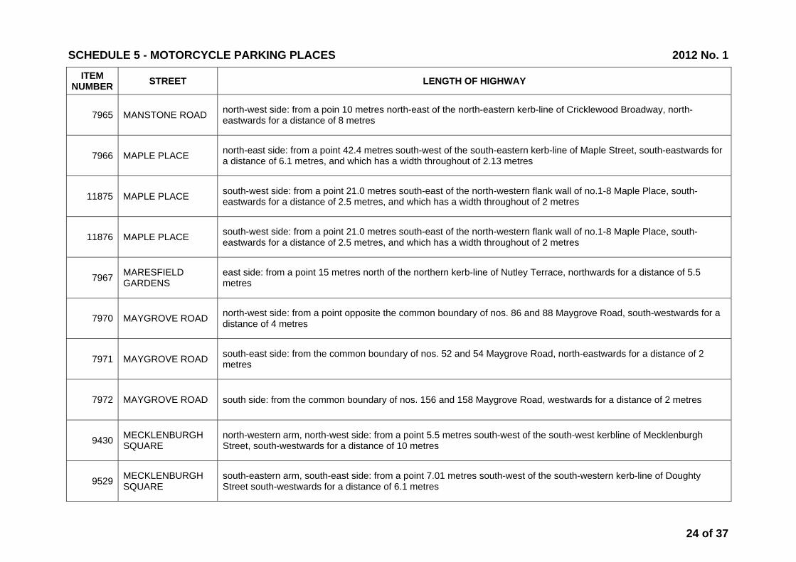
7965 MANSTONE ROAD north-west side: from a poin 10 metres north-east of the north-eastern kerb-line of Cricklewood Broadway, north-eastwards for a distance of 8 metres
7966 MAPLE PLACE north-east side: from a point 42.4 metres south-west of the south-eastern kerb-line of Maple Street, south-eastwards for a distance of 6.1 metres, and which has a width throughout of 2.13 metres
11875 MAPLE PLACE south-west side: from a point 21.0 metres south-east of the north-western flank wall of no.1-8 Maple Place, south-eastwards for a distance of 2.5 metres, and which has a width throughout of 2 metres
11876 MAPLE PLACE south-west side: from a point 21.0 metres south-east of the north-western flank wall of no.1-8 Maple Place, south-eastwards for a distance of 2.5 metres, and which has a width throughout of 2 metres
7967 MARESFIELD GARDENS
east side: from a point 15 metres north of the northern kerb-line of Nutley Terrace, northwards for a distance of 5.5 metres
7970 MAYGROVE ROAD north-west side: from a point opposite the common boundary of nos. 86 and 88 Maygrove Road, south-westwards for a distance of 4 metres
7971 MAYGROVE ROAD south-east side: from the common boundary of nos. 52 and 54 Maygrove Road, north-eastwards for a distance of 2 metres
7972 MAYGROVE ROAD south side: from the common boundary of nos. 156 and 158 Maygrove Road, westwards for a distance of 2 metres
9430 MECKLENBURGH SQUARE
north-western arm, north-west side: from a point 5.5 metres south-west of the south-west kerbline of Mecklenburgh Street, south-westwards for a distance of 10 metres
9529 MECKLENBURGH SQUARE
south-eastern arm, south-east side: from a point 7.01 metres south-west of the south-western kerb-line of Doughty Street south-westwards for a distance of 6.1 metres
SCHEDULE 5 - MOTORCYCLE PARKING PLACES 2012 No. 1
24 of 37

ITEM NUMBER STREET LENGTH OF HIGHWAY
7975 MERTON RISE east side: from a point 50 metres south of the southern kerb-line of Eton Avenue, southwards for a distance of 2.5 metres
7976 MIDHOPE STREET west side: from a point 6.1 metres north of the northern kerb-line of Cromer Street, northwards for a distance of 6.1 metres, and which has a width throughout of 2.13 metres
10434 MILL LANE north side: from a point 7.0 metres west of the western kerb line of Gondar Gardens, westwards for a distance of 3.0 metres and has a width throughout of 2.0 metres
11269 MILL LANE north side: from a point 25.4 metres west of the party wall of nos. 9 and 11 Mill Lane, westwards for a distance of 2.5 metres and has a width throughout of 1.83 metres
7979 MINSTER ROAD south-east side: from a point 3.75 metres north-east of the eastern kerb-line of Sarre Road, north-westwards for a distance of 3 metres
9315 MINSTER ROAD north-west side: from a point 12.0 metres north-east of the north-eastern kerbline of Shoot-up Hill north-eastwards for a distance of 3.0 metres
7981 MORNINGTON CRESCENT
south-east side: from a point opposite the party wall of nos. 42 and 43 Mornington Crescent, north-eastwards for a distance of 6.1 metres, and which has a width throughout of 1.83 metres
10799 MORNINGTON TERRACE
west side: from a point 3.6 metres north of a point opposite the northern kerb line of Mornington Place, northwards for a distance of 5.8 metres
7982 MORTIMER MARKET
south-western arm, south-west side: from a point 1.5 metres south-east of the south-eastern kerb-line of the access road to Tottenham Court Road, south-eastwards for a distance of 5.2 metres, and which has a width throughout of 1.83 metres;
7985 MORWELL STREET south-west side: from a point 30.5 metres north-west of the north-western kerb-line of Bedford Avenue, north-westwards for a distance of 4.6 metres, and which has a width throughout of 1.83 metres;
SCHEDULE 5 - MOTORCYCLE PARKING PLACES 2012 No. 1
25 of 37
ITEM NUMBER STREET LENGTH OF HIGHWAY
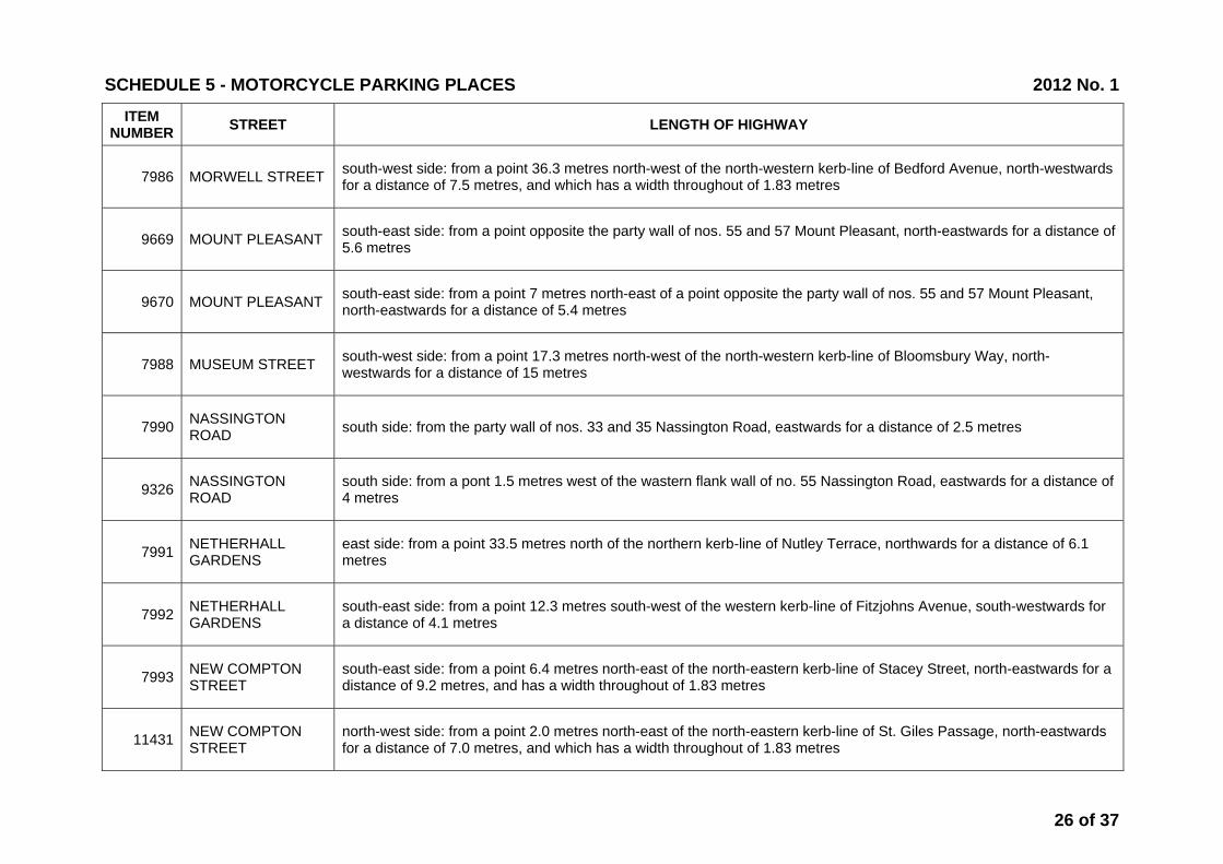
7986 MORWELL STREET south-west side: from a point 36.3 metres north-west of the north-western kerb-line of Bedford Avenue, north-westwards for a distance of 7.5 metres, and which has a width throughout of 1.83 metres
9669 MOUNT PLEASANT south-east side: from a point opposite the party wall of nos. 55 and 57 Mount Pleasant, north-eastwards for a distance of 5.6 metres
9670 MOUNT PLEASANT south-east side: from a point 7 metres north-east of a point opposite the party wall of nos. 55 and 57 Mount Pleasant, north-eastwards for a distance of 5.4 metres
7988 MUSEUM STREET south-west side: from a point 17.3 metres north-west of the north-western kerb-line of Bloomsbury Way, north-westwards for a distance of 15 metres
7990 NASSINGTON ROAD south side: from the party wall of nos. 33 and 35 Nassington Road, eastwards for a distance of 2.5 metres
9326 NASSINGTON ROAD
south side: from a pont 1.5 metres west of the wastern flank wall of no. 55 Nassington Road, eastwards for a distance of 4 metres
7991 NETHERHALL GARDENS
east side: from a point 33.5 metres north of the northern kerb-line of Nutley Terrace, northwards for a distance of 6.1 metres
7992 NETHERHALL GARDENS
south-east side: from a point 12.3 metres south-west of the western kerb-line of Fitzjohns Avenue, south-westwards for a distance of 4.1 metres
7993 NEW COMPTON STREET
south-east side: from a point 6.4 metres north-east of the north-eastern kerb-line of Stacey Street, north-eastwards for a distance of 9.2 metres, and has a width throughout of 1.83 metres
11431 NEW COMPTON STREET
north-west side: from a point 2.0 metres north-east of the north-eastern kerb-line of St. Giles Passage, north-eastwards for a distance of 7.0 metres, and which has a width throughout of 1.83 metres
SCHEDULE 5 - MOTORCYCLE PARKING PLACES 2012 No. 1
26 of 37
ITEM NUMBER STREET LENGTH OF HIGHWAY
7994 NEW OXFORD STREET
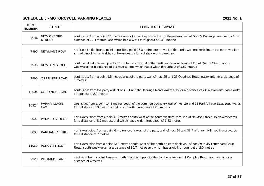
south side: from a point 3.1 metres west of a point opposite the south-western limit of Dunn's Passage, westwards for a distance of 10.4 metres, and which has a width throughout of 1.83 metres
7995 NEWMANS ROW north-east side: from a point opposite a point 16.8 metres north-west of the north-western kerb-line of the north-western arm of Lincoln's Inn Fields, north-westwards for a distance of 4.6 metres
7996 NEWTON STREET south-west side: from a point 27.1 metres north-west of the north-western kerb-line of Great Queen Street, north-westwards for a distance of 5.1 metres, and which has a width throughout of 1.83 metres
7999 OSPRINGE ROAD south side: from a point 1.5 metres west of the party wall of nos. 25 and 27 Ospringe Road, eastwards for a distance of 5 metres
10904 OSPRINGE ROAD south side: from the party wall of nos. 31 and 32 Ospringe Road, eastwards for a distance of 2.0 metres and has a width throughout of 2.0 metres
10924 PARK VILLAGE EAST
west side: from a point 14.3 metres south of the common boundary wall of nos. 26 and 28 Park Village East, southwards for a distance of 3.0 metres and has a width throughout of 2.0 metres
8002 PARKER STREET north-west side: from a point 6.0 metres south-west of the south-western kerb-line of Newton Street, south-westwards for a distance of 8.7 metres, and which has a width throughout of 1.83 metres
8003 PARLIAMENT HILL north-west side: from a point 6 metres south-west of the party wall of nos. 29 and 31 Parliament Hill, south-westwards for a distance of 7 metres
11960 PERCY STREET north-west side from a point 13.8 metres south-west of the north-eastern flank wall of nos.39 to 45 Tottenham Court Road, south-westwards for a distance of 10.7 metres and which has a width throughout of 2.0 metres
9323 PILGRIM'S LANE east side: from a point 3 metres north of a point opposite the southern kerbline of Kemplay Road, northwards for a distance of 4 metres
SCHEDULE 5 - MOTORCYCLE PARKING PLACES 2012 No. 1
27 of 37

ITEM NUMBER STREET LENGTH OF HIGHWAY
8006 POLYGON ROAD north-west side: from a point 6.1 metres north-east of the north-eastern kerb-line of Werrington Street, north-eastwards for a distance of 15.3 metres, and which has a width throughout of 1.5 metres
9559 PORTPOOL LANE north side: from the party wall of no. 81 Leather Lane and nos. 1-5 Portpool Lane, westwards for a distance of 7 metres
11514 PORTPOOL LANE south-east side: from a point 36.1 metres south-west of the north-eastern wall of nos. 1-30 Gooch House, south-westwards for a distance of 4 meters, and which has a width throughout of 2.0 metres
8008 PRATT STREET south-east side: from a point 4.6 metres south-west of a point opposite the south-western entrance to St Martin's Gardens, north-eastwards for a distance of 9.1 metres, and which has a width throughout of 1.83 metres
8009 PRIMROSE GARDENS
north-east side: from a point 6 metres north-west of the north-western kerb-line of Elizabeth Mews, north-westwards for a distance of 4 metres
10006 PRINCE OF WALES ROAD south side: from the eastern flank wall fo no. 99 Prince of Wales Road, eastwards for a distance of 4 metres
11267 PRINCE OF WALES ROAD
south side: from a point 24.30 metres west of the eastern flank wall of no.1 Prince of Wales Road, westwards for a distance of 2.0 metres and has a width throughout of 1.83 metres
9349 PRINCESS ROAD north-west side: from a point 4 metres north of the northern kerb-line of Kingstown Street, northwards for a distance of 3 metres
8010 PRIORY ROAD south-west side: from a point 8 metres north-west of the north-western kerb-line of Belsize Road, north-westwards for a distance of 8.5 metres
8011 PROVOST ROAD south side: from a point 13 metres east of the south-eastern kerb-line of Eton Road, eastwards for a distance of 2.5 metres
SCHEDULE 5 - MOTORCYCLE PARKING PLACES 2012 No. 1
28 of 37
ITEM NUMBER STREET LENGTH OF HIGHWAY
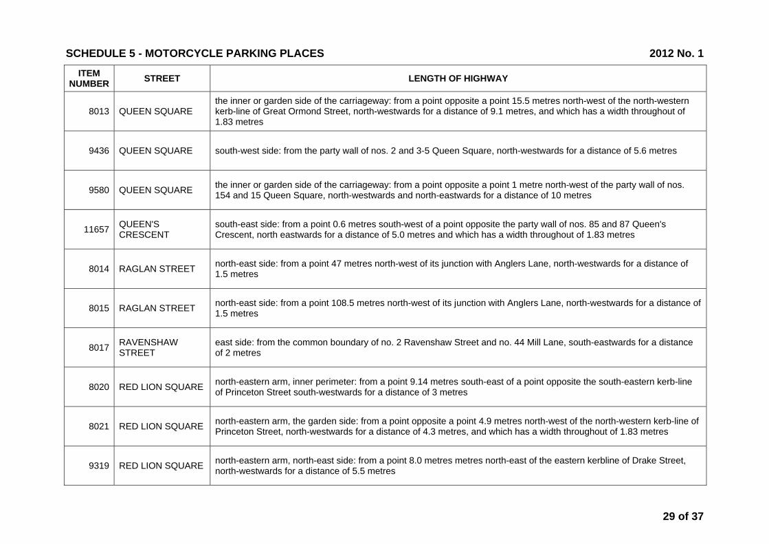
8013 QUEEN SQUARE the inner or garden side of the carriageway: from a point opposite a point 15.5 metres north-west of the north-western kerb-line of Great Ormond Street, north-westwards for a distance of 9.1 metres, and which has a width throughout of 1.83 metres
9436 QUEEN SQUARE south-west side: from the party wall of nos. 2 and 3-5 Queen Square, north-westwards for a distance of 5.6 metres
9580 QUEEN SQUARE the inner or garden side of the carriageway: from a point opposite a point 1 metre north-west of the party wall of nos. 154 and 15 Queen Square, north-westwards and north-eastwards for a distance of 10 metres
11657 QUEEN'S CRESCENT
south-east side: from a point 0.6 metres south-west of a point opposite the party wall of nos. 85 and 87 Queen's Crescent, north eastwards for a distance of 5.0 metres and which has a width throughout of 1.83 metres
8014 RAGLAN STREET north-east side: from a point 47 metres north-west of its junction with Anglers Lane, north-westwards for a distance of 1.5 metres
8015 RAGLAN STREET north-east side: from a point 108.5 metres north-west of its junction with Anglers Lane, north-westwards for a distance of 1.5 metres
8017 RAVENSHAW STREET
east side: from the common boundary of no. 2 Ravenshaw Street and no. 44 Mill Lane, south-eastwards for a distance of 2 metres
8020 RED LION SQUARE north-eastern arm, inner perimeter: from a point 9.14 metres south-east of a point opposite the south-eastern kerb-line of Princeton Street south-westwards for a distance of 3 metres
8021 RED LION SQUARE north-eastern arm, the garden side: from a point opposite a point 4.9 metres north-west of the north-western kerb-line of Princeton Street, north-westwards for a distance of 4.3 metres, and which has a width throughout of 1.83 metres
9319 RED LION SQUARE north-eastern arm, north-east side: from a point 8.0 metres metres north-east of the eastern kerbline of Drake Street, north-westwards for a distance of 5.5 metres
SCHEDULE 5 - MOTORCYCLE PARKING PLACES 2012 No. 1
29 of 37
ITEM NUMBER STREET LENGTH OF HIGHWAY
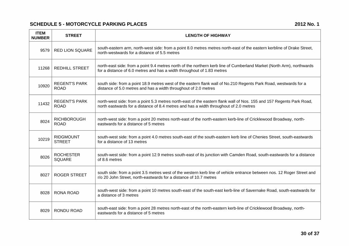
9579 RED LION SQUARE south-eastern arm, north-west side: from a point 8.0 metres metres north-east of the eastern kerbline of Drake Street, north-westwards for a distance of 5.5 metres
11268 REDHILL STREET north-east side: from a point 9.4 metres north of the northern kerb line of Cumberland Market (North Arm), northwards for a distance of 6.0 metres and has a width throughout of 1.83 metres
10920 REGENT'S PARK ROAD
south side: from a point 18.9 metres west of the eastern flank wall of No.210 Regents Park Road, westwards for a distance of 5.0 metres and has a width throughout of 2.0 metres
11432 REGENT'S PARK ROAD
north-west side: from a point 5.3 metres north-east of the eastern flank wall of Nos. 155 and 157 Regents Park Road, north eastwards for a distance of 8.4 metres and has a width throughout of 2.0 metres
8024 RICHBOROUGH ROAD
north-west side: from a point 20 metres north-east of the north-eastern kerb-line of Cricklewood Broadway, north-eastwards for a distance of 5 metres
10219 RIDGMOUNT STREET
south-west side: from a point 4.0 metres south-east of the south-eastern kerb line of Chenies Street, south-eastwards for a distance of 13 metres
8026 ROCHESTER SQUARE
south-west side: from a point 12.9 metres south-east of its junction with Camden Road, south-eastwards for a distance of 8.6 metres
8027 ROGER STREET south side: from a point 3.5 metres west of the western kerb line of vehicle entrance between nos. 12 Roger Street and r/o 20 John Street, north-eastwards for a distance of 10.7 metres
8028 RONA ROAD south-west side: from a point 10 metres south-east of the south-east kerb-line of Savernake Road, south-eastwards for a distance of 3 metres
8029 RONDU ROAD south-east side: from a point 28 metres north-east of the north-eastern kerb-line of Cricklewood Broadway, north-eastwards for a distance of 5 metres
SCHEDULE 5 - MOTORCYCLE PARKING PLACES 2012 No. 1
30 of 37

ITEM NUMBER STREET LENGTH OF HIGHWAY
8030 ROSEMONT ROAD north side: from a point 11.9 metres west of the common boundary of nos. 13 and 15 Rosemont Road, westwards for a distance of 10 metres
10610 ROYAL COLLEGE STREET
north-west side: from a point 3.5 metres north of the party wall of nos. 20 and 22 Royal College Street, north-westwards fro a distance 9.7 metres
10654 ROYAL COLLEGE STREET
south-west side: from a point 2.5 metres south-east of the party wall of nos. 223 and 225 Royal College Street, south-eastwards for a distance of 12.0 metres
10083 RUSSELL SQUARE north-western arm, inner perimeter: from a point 1 metres north-east of the south-western kerbline of Bedford Way, north-eastwards for a distance of 6.5 metres
10130 RUSSELL SQUARE north-western arm: from a point 1.5 metres north-east of a point opposite the party wall of nos. 21 and 22 Russell Square, south-westwards for a distance of 4.5 metres
10274 RUSSELL SQUARE south-western arm, north-east side: from a point 6.1 metres south-east of the north-western kerb-line of Montague Place, north-westwards for a distance of 24 metres
10276 RUSSELL SQUARE south-eastern arm, south-east side: from a point 1.2 metres north-east of the common boundary of nos. 46 and 47 Russell Square, north-eastwards for a distance of 6 metres
12258 RUSSELL SQUARE south-east arm, south-east side: from a point 4.0 metres north-east of the boundary wall of nos. 44 and 45 Russell Square, north-eastwards for a distance of 23.0 metres and having a width throughout of 2.0 metres
12259 RUSSELL SQUARE south-west arm, south-west side: from the boundary wall of nos. 28 and 29 Russell Square, south-eastwards for a distance of 18.20 metres and having a width throughout of 2.0 metres
12260 RUSSELL SQUARE north-west arm, north-west side: from a point 23.30 metres south-west of the north-east flank wall of no.9 Russell Square, south-westwards for a distance of 9.0 metres and having a width throughout of 2.0 metres
SCHEDULE 5 - MOTORCYCLE PARKING PLACES 2012 No. 1
31 of 37

ITEM NUMBER STREET LENGTH OF HIGHWAY
11508 SAFFRON HILL north-east side: from a point 16.5 metres south-east of the south-eastern kerb-line of Hatton Wall, south-eastwards for a distance of 13.5 metres, and which has a width throughout of 1.8 metres
9321 SAFFRON STREET north-west side: from a point 6 metres north-east of the north-eastern kerb-line of Onslow Street, north-eastwards for a distance of 5.5 metres
9317 SANDLAND STREET
south side: from a point 45 metres east of the eastern kerbline of Red Lion Street, eastwards for a distance of 3.0 metres and which has a width throughout of 2.0 metres
8046 SAVERNAKE ROAD north side: from a point 0.5 metres west of the party wall of nos. 66 and 68 Savernake Road, westwards for a distance of 2.5 metres
8047 SHAFTESBURY AVENUE
north-west side: from a point 16.8 metres south-west of a point opposite the extended south-west kerb-line of Grape Street, south-westwards for a distance of 4.2 metres
8049 SHERRIFF ROAD north side: from the eastern boundary wall of no. 169a West End Lane, westwards for a distance of 5 metres
8050 SHIRLOCK ROAD north-east side: from a point 18.3 metres south-east of the southern kerb-line of Savernake Road, south-eastwards for a distance of 2 metres
11941 SIDMOUTH STREET
south-east side from a point 49.1 metres north-east of a point opposite the north-eastern kerbline Seaford Street, north-eastwards for a distance of 10.1 metres
8051 SKARDU ROAD north-west side: from the common boundary of nos. 14 and 16 Skardu Road, south-westwards for a distance of 5 metres
8052 SKARDU ROAD south-east side: from a point 23 metres north-east of the north-eastern kerb-line of Cricklewood Broadway, north-eastwards for a distance of 5 metres
SCHEDULE 5 - MOTORCYCLE PARKING PLACES 2012 No. 1
32 of 37

ITEM NUMBER STREET LENGTH OF HIGHWAY
8053 SOLENT ROAD west side: from the north-western boundary line of no. 7 Solent Road, south-eastwards for a distance of 2 metres
11516 SOUTH CRESCENT south side: from a point 3.8 metres south-west of the common boundary of nos. 25 and 26 Store Street, north eastwards for a distance of 10.9 metres, and which has a width throughout of 2.0 metres;
11517 SOUTH CRESCENT north side: from an extended point opposite the western flank wall of 21a Store Street, north-eastwards for a distance of 7.0 metres and which has a width throughout of 2.0 metres
8454 SOUTH GROVE south-east side: from the party wall of nos. 10a and 11 South Grove, north-eastwards for a distance of 2.1 metres and which has a width throughout of 4.5 metres.
8057 SOUTH HILL PARK east side: from a point 10.5 metres north of the northern kerb-line of Parliament Hill, northwards for a distance of 7 metres
8058 SOUTH HILL PARK south-east side: from a point 1 metre north-east of the boundary wall between nos. 22 and 24 South Hill Park Gardens, north-eastwards for a distance of 3 metres and which has a width throughout of 1.8 metres
9325 SOUTH HILL PARK west side: from a point 3.8 metres north of the party wall of nos. 76 and 78 South Hill Park, northwards for a distance of 4 metres
10080 SOUTHAMPTON ROAD
east side: from a point 1 metre north of the common boundary of nos. 34 and 36 Southampton Road northwards for a distance of 5 metres
11509 SOUTHAMPTON ROAD
south-west side: frrom a point 16.7 metres south-east of the southern kerb-line of Kingsford Street, south eastwards for a distance of 7.4 metres and which has a width throughout of 1.83 metres
8059 SPRING PLACE north-east side: from a point 24 metres north-west of its junction with Holmes Road, north-westwards for a distance of 10 metres
SCHEDULE 5 - MOTORCYCLE PARKING PLACES 2012 No. 1
33 of 37
ITEM NUMBER STREET LENGTH OF HIGHWAY
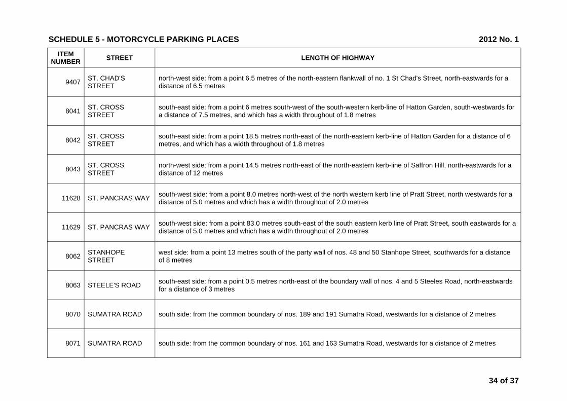
9407 ST. CHAD'S STREET
north-west side: from a point 6.5 metres of the north-eastern flankwall of no. 1 St Chad's Street, north-eastwards for a distance of 6.5 metres
8041 ST. CROSS STREET
south-east side: from a point 6 metres south-west of the south-western kerb-line of Hatton Garden, south-westwards for a distance of 7.5 metres, and which has a width throughout of 1.8 metres
8042 ST. CROSS STREET
south-east side: from a point 18.5 metres north-east of the north-eastern kerb-line of Hatton Garden for a distance of 6 metres, and which has a width throughout of 1.8 metres
8043 ST. CROSS STREET
north-west side: from a point 14.5 metres north-east of the north-eastern kerb-line of Saffron Hill, north-eastwards for a distance of 12 metres
11628 ST. PANCRAS WAY south-west side: from a point 8.0 metres north-west of the north western kerb line of Pratt Street, north westwards for a distance of 5.0 metres and which has a width throughout of 2.0 metres
11629 ST. PANCRAS WAY south-west side: from a point 83.0 metres south-east of the south eastern kerb line of Pratt Street, south eastwards for a distance of 5.0 metres and which has a width throughout of 2.0 metres
8062 STANHOPE STREET
west side: from a point 13 metres south of the party wall of nos. 48 and 50 Stanhope Street, southwards for a distance of 8 metres
8063 STEELE'S ROAD south-east side: from a point 0.5 metres north-east of the boundary wall of nos. 4 and 5 Steeles Road, north-eastwards for a distance of 3 metres
8070 SUMATRA ROAD south side: from the common boundary of nos. 189 and 191 Sumatra Road, westwards for a distance of 2 metres
8071 SUMATRA ROAD south side: from the common boundary of nos. 161 and 163 Sumatra Road, westwards for a distance of 2 metres
SCHEDULE 5 - MOTORCYCLE PARKING PLACES 2012 No. 1
34 of 37

ITEM NUMBER STREET LENGTH OF HIGHWAY
9557 SWAIN'S LANE from a point 3.5 metres west of the party wall of nos. 8 and 10 Swain’s Lane, eastwards for a distance of 5 metres
8074 TANKERTON STREET
west side: from a point 6.1 metres north of the northern kerb-line of Cromer Street, northwards for a distance of 6.1 metres, and which has a width throughout of 2.13 metres
8075 TANZA ROAD north-east side: from a point 5.1 metres north-west of the northern kerb-line of Nassington Road, for a distance of 2.5 metres
10267 TAVISTOCK SQUARE
north-western arm, south-east side: from a point 41.4 metres north-east of the north-eastern kerb-line of the south-western arm of Tavistock Square, north-eastwards for a distance of 12.4 metres
10249 TAVITON STREET south-west side: from a point 7.6 metres south-east of the south-eastern kerb-line of Endsleigh Gardens, south-eastwards for a distance of 12.2 metres
9703 TEMPLEWOOD AVENUE west side: from a point 6 metres east of the eastern kerbline of Fitzjohn's Avenue, eastwards for a distance of 4 metres
10307 TOTTENHAM STREET
south-east side: from a point 14 metres south-west of the south-western kerb line of Whitfield Street, south-westwards for a distance of 5.0 metres
8080 TOWER STREET south-west side: from a point opposite the north-western wall of no. 21 Tower Street, south-eastwards for a distance of 7.8 metres, and which has a width throughout of 1.83 metres
10752 TWISDEN ROAD north-eastern arm, north-east side: from a point 25.5 metres south-east of the north-western flank wall of no. 56 Chetwynd Road, south-eastwards for a distance of 4.0 metres
8083 UNIVERSITY STREET
south side: from a point 52 metres east of the eastern kerb-line of Tottenham Court Road, eastwards for a distance of 10 metres, and which has a width throughout of 2.13 metres
SCHEDULE 5 - MOTORCYCLE PARKING PLACES 2012 No. 1
35 of 37
ITEM NUMBER STREET LENGTH OF HIGHWAY
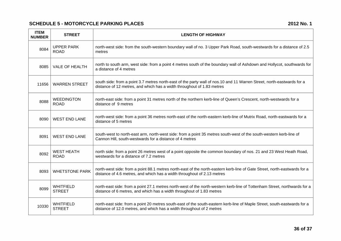
8084 UPPER PARK ROAD
north-west side: from the south-western boundary wall of no. 3 Upper Park Road, south-westwards for a distance of 2.5 metres
8085 VALE OF HEALTH north to south arm, west side: from a point 4 metres south of the boundary wall of Ashdown and Hollycot, southwards for a distance of 4 metres
11656 WARREN STREET south side: from a point 3.7 metres north-east of the party wall of nos.10 and 11 Warren Street, north-eastwards for a distance of 12 metres, and which has a width throughout of 1.83 metres
8088 WEEDINGTON ROAD
north-east side: from a point 31 metres north of the northern kerb-line of Queen’s Crescent, north-westwards for a distance of 9 metres
8090 WEST END LANE north-west side: from a point 36 metres north-east of the north-eastern kerb-line of Mutrix Road, north-eastwards for a distance of 5 metres
8091 WEST END LANE south-west to north-east arm, north-west side: from a point 35 metres south-west of the south-western kerb-line of Cannon Hill, south-westwards for a distance of 4 metres
8092 WEST HEATH ROAD
north side: from a point 26 metres west of a point opposite the common boundary of nos. 21 and 23 West Heath Road, westwards for a distance of 7.2 metres
8093 WHETSTONE PARK north-west side: from a point 88.1 metres north-east of the north-eastern kerb-line of Gate Street, north-eastwards for a distance of 4.6 metres, and which has a width throughout of 2.13 metres
8099 WHITFIELD STREET
north-east side: from a point 27.1 metres north-west of the north-western kerb-line of Tottenham Street, northwards for a distance of 6 metres, and which has a width throughout of 1.83 metres
10330 WHITFIELD STREET
north-east side: from a point 20 metres south-east of the south-eastern kerb-line of Maple Street, south-eastwards for a distance of 12.0 metres, and which has a width throughout of 2 metres
SCHEDULE 5 - MOTORCYCLE PARKING PLACES 2012 No. 1
36 of 37

ITEM NUMBER STREET LENGTH OF HIGHWAY
10782 WHITFIELD STREET
north-east side: from a point 11.2 metres south-east of the south-eastern kerb line of Goodge Street, south-eastwards for a distance of 9.8 metres and has a width throughout of 2.0 metres
8100 WICKLOW STREET north-west side: from the south-western flank wall of no. 121-144 Derby Lodge, south-westwards for a distance of 7.5 metres
8101 WILLIAM ROAD south side: from a point 25.9 metres west of a point opposite the party wall of nos. 11 to 15 and nos. 35 to 37 William Road, westwards for a distance of 9.1 metres, and which has a width throughout of 1.83 metres
10902 WINCHESTER ROAD
west side: from a point 27.5 metres north of the northern kerb line of Adelaide Road, northwards for a distance of 3.0 metres and has a width throughout of 2.0 metres
8572 YORK RISE south-west side: from the north-western flank wall of no. 49 Dartmouth Park Road, south-eastwards for a distance of 3 metres
SCHEDULE 5 - MOTORCYCLE PARKING PLACES 2012 No. 1
37 of 37