sector guide fishing year 2018 flounder (fluke), black sea bass, and scup (porgies) emily gilbert...
TRANSCRIPT
GARFO Contact Information, by Fishery 1-5
Monitoring and Reporting Flowchart 6-7
Redfish Exemption Guidance 8-9
Small Mesh Exemption Guidance 10-11
Extra Large Mesh Exemption Guidance 12-13
Catch Reporting Guidance 14
Catch Reporting Flowchart 15
PTNS Instructions 16-33
ASM Duties 34-35
VTR Overview 36-39
VTR FAQ’s 40-41
Sector Vessel Requirements 42
US/Canada Management Areas & SAP 43-47
Skate 48-50
Spiny Dogfish 51-54
Monkfish 55-62
FOL Instructions 63-64
Reporting Requirement Notes 65
Closed Area Regulations 66-88
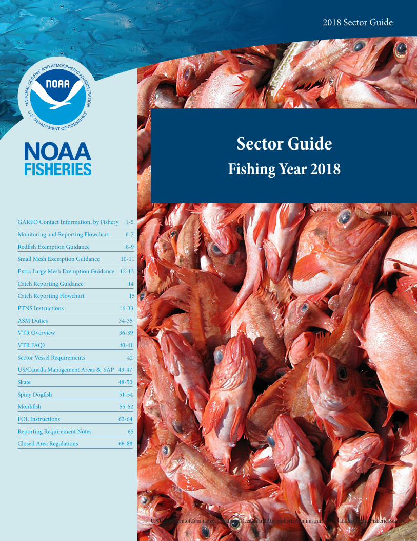
Sector GuideFishing Year 2018
Northeast Enforcement Division | 2015
U.S.DepartmentofCommerce | NationalOceanicandAtmosphericAdministration | NationalMarineFisheriesService
2018 Sector Guide
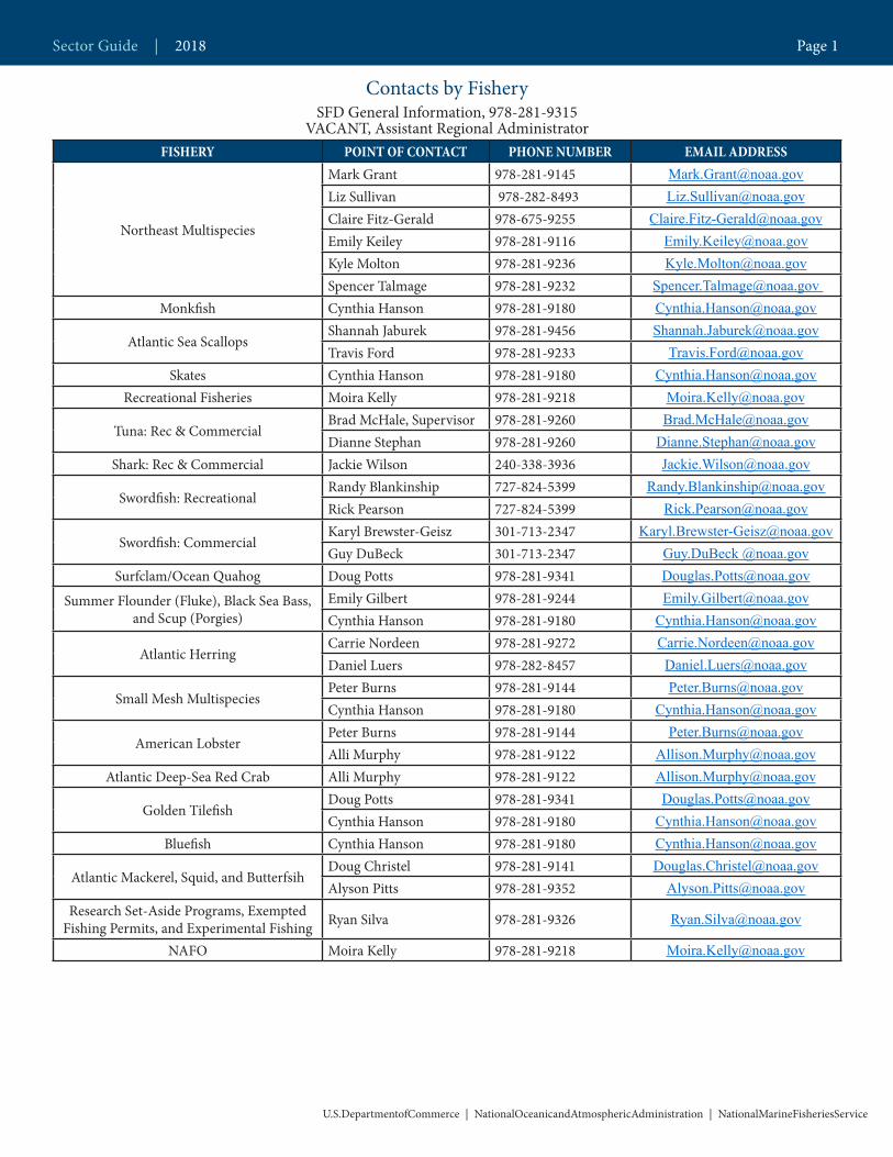
Contacts by Fishery SFD General Information, 978-281-9315
VACANT, Assistant Regional AdministratorFISHERY POINT OF CONTACT PHONE NUMBER EMAIL ADDRESS
Northeast Multispecies
Mark Grant 978-281-9145 [email protected] Sullivan 978-282-8493 [email protected] Fitz-Gerald 978-675-9255 [email protected] Keiley 978-281-9116 [email protected] Molton 978-281-9236 [email protected] Talmage 978-281-9232 [email protected]
Monkfish Cynthia Hanson 978-281-9180 [email protected]
Atlantic Sea Scallops Shannah Jaburek 978-281-9456 [email protected] Ford 978-281-9233 [email protected]
Skates Cynthia Hanson 978-281-9180 [email protected] Fisheries Moira Kelly 978-281-9218 [email protected]
Tuna: Rec & CommercialBrad McHale, Supervisor 978-281-9260 [email protected] Stephan 978-281-9260 [email protected]
Shark: Rec & Commercial Jackie Wilson 240-338-3936 [email protected]
Swordfish: RecreationalRandy Blankinship 727-824-5399 [email protected] Pearson 727-824-5399 [email protected]
Swordfish: CommercialKaryl Brewster-Geisz 301-713-2347 [email protected] DuBeck 301-713-2347 Guy.DuBeck @noaa.gov
Surfclam/Ocean Quahog Doug Potts 978-281-9341 [email protected]
Summer Flounder (Fluke), Black Sea Bass, and Scup (Porgies)
Emily Gilbert 978-281-9244 [email protected] Hanson 978-281-9180 [email protected]
Atlantic Herring Carrie Nordeen 978-281-9272 [email protected] Luers 978-282-8457 [email protected]
Small Mesh MultispeciesPeter Burns 978-281-9144 [email protected] Hanson 978-281-9180 [email protected]
American LobsterPeter Burns 978-281-9144 [email protected] Murphy 978-281-9122 [email protected]
Atlantic Deep-Sea Red Crab Alli Murphy 978-281-9122 [email protected]
Golden Tilefish Doug Potts 978-281-9341 [email protected] Hanson 978-281-9180 [email protected]
Bluefish Cynthia Hanson 978-281-9180 [email protected]
Atlantic Mackerel, Squid, and Butterfsih Doug Christel 978-281-9141 [email protected] Pitts 978-281-9352 [email protected]
Research Set-Aside Programs, Exempted Fishing Permits, and Experimental Fishing Ryan Silva 978-281-9326 [email protected]
NAFO Moira Kelly 978-281-9218 [email protected]
Sector Guide | 2018 Page 1
U.S.DepartmentofCommerce | NationalOceanicandAtmosphericAdministration | NationalMarineFisheriesService
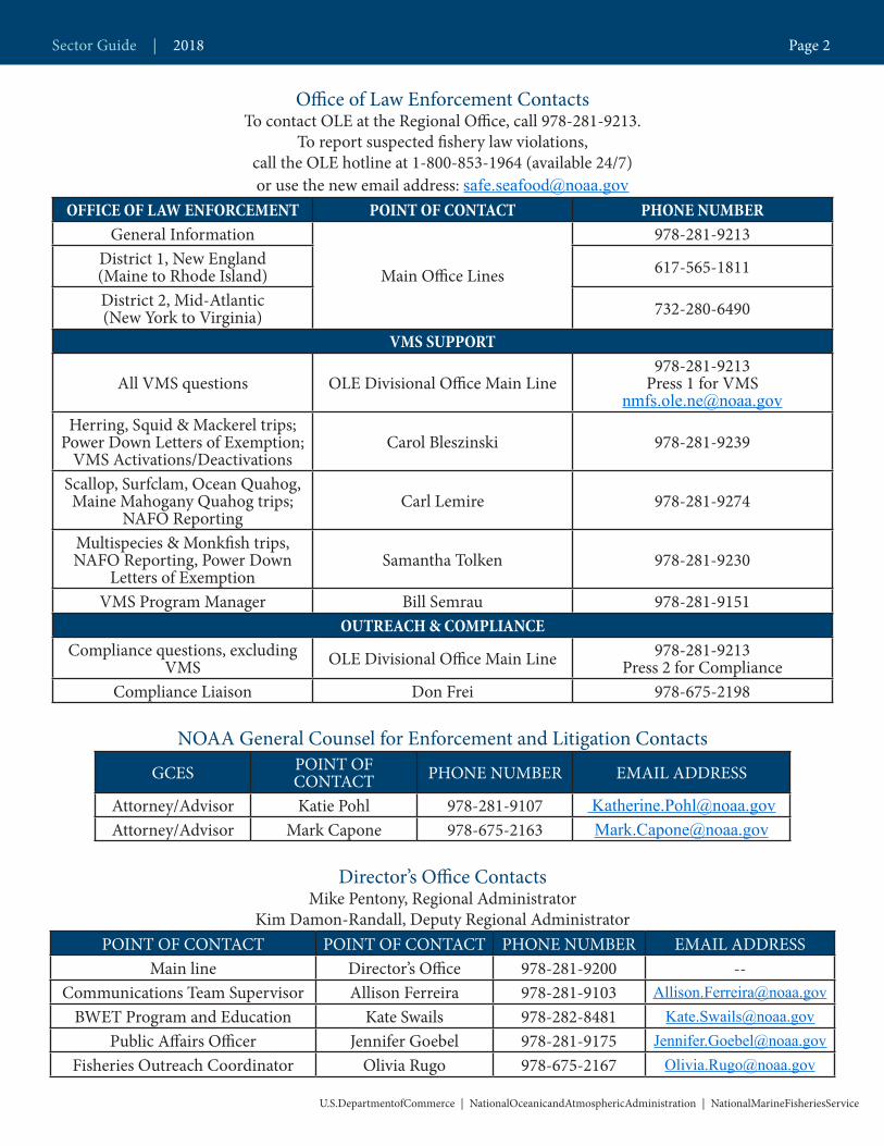
Office of Law Enforcement Contacts To contact OLE at the Regional Office, call 978-281-9213.
To report suspected fishery law violations, call the OLE hotline at 1-800-853-1964 (available 24/7)or use the new email address: [email protected]
OFFICE OF LAW ENFORCEMENT POINT OF CONTACT PHONE NUMBERGeneral Information
Main Office Lines
978-281-9213District 1, New England (Maine to Rhode Island) 617-565-1811
District 2, Mid-Atlantic (New York to Virginia) 732-280-6490
VMS SUPPORT
All VMS questions OLE Divisional Office Main Line978-281-9213
Press 1 for [email protected]
Herring, Squid & Mackerel trips;Power Down Letters of Exemption;
VMS Activations/DeactivationsCarol Bleszinski 978-281-9239
Scallop, Surfclam, Ocean Quahog, Maine Mahogany Quahog trips;
NAFO ReportingCarl Lemire 978-281-9274
Multispecies & Monkfish trips, NAFO Reporting, Power Down
Letters of ExemptionSamantha Tolken 978-281-9230
VMS Program Manager Bill Semrau 978-281-9151OUTREACH & COMPLIANCE
Compliance questions, excluding VMS OLE Divisional Office Main Line 978-281-9213
Press 2 for ComplianceCompliance Liaison Don Frei 978-675-2198
NOAA General Counsel for Enforcement and Litigation Contacts
GCES POINT OF CONTACT PHONE NUMBER EMAIL ADDRESS
Attorney/Advisor Katie Pohl 978-281-9107 [email protected] Attorney/Advisor Mark Capone 978-675-2163 [email protected]
Director’s Office ContactsMike Pentony, Regional Administrator
Kim Damon-Randall, Deputy Regional Administrator POINT OF CONTACT POINT OF CONTACT PHONE NUMBER EMAIL ADDRESS
Main line Director’s Office 978-281-9200 --Communications Team Supervisor Allison Ferreira 978-281-9103 [email protected]
BWET Program and Education Kate Swails 978-282-8481 [email protected] Affairs Officer Jennifer Goebel 978-281-9175 [email protected]
Fisheries Outreach Coordinator Olivia Rugo 978-675-2167 [email protected]
Sector Guide | 2018 Page 2
U.S.DepartmentofCommerce | NationalOceanicandAtmosphericAdministration | NationalMarineFisheriesService
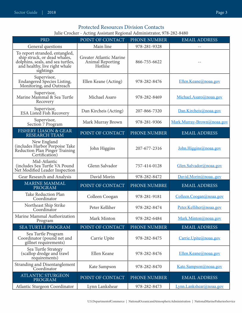
Protected Resources Division ContactsJulie Crocker - Acting Assistant Regional Administrator, 978-282-8480
PRD POINT OF CONTACT PHONE NUMBER EMAIL ADDRESSGeneral questions Main line 978-281-9328 --
To report stranded, entangled, ship struck, or dead whales,
dolphins, seals, and sea turtles, and healthy, live right whale
sightings
Greater Atlantic Marine Animal Reporting
Hotline866-755-6622 --
Supervisor, Endangered Species Listing, Monitoring, and Outreach
Ellen Keane (Acting) 978-282-8476 [email protected]
Supervisor, Marine Mammal & Sea Turtle
RecoveryMichael Asaro 978-282-8469 [email protected]
Supervisor,ESA Listed Fish Recovery Dan Kircheis (Acting) 207-866-7320 [email protected]
Supervisor, Section 7 Program Mark Murray Brown 978-281-9306 [email protected]
FISHERY LIASON & GEAR RESEARCH TEAM POINT OF CONTACT PHONE NUMBER EMAIL ADDRESS
New England (includes Harbor Porpoise Take Reduction Plan Pinger Training
Certification)John Higgins 207-677-2316 [email protected]
Mid-Atlantic (includes Sea Turtle VA Pound
Net Modified Leader InspectionGlenn Salvador 757-414-0128 [email protected]
Gear Research and Analysis David Morin 978-282-8472 [email protected] MAMMAL
PROGRAM POINT OF CONTACT PHONE NUMBRE EMAIL ADDRESS
Take Reduction Plan Coordinator Colleen Coogan 978-281-9181 [email protected]
Northeast Ship Strike Coordinator Peter Kelliher 978-282-8474 [email protected]
Marine Mammal Authorization Program Mark Minton 978-282-6484 [email protected]
SEA TURTLE PROGRAM POINT OF CONTACT PHONE NUMBER EMAIL ADDRESSSea Turtle Program
Coordinator (pound net and gillnet requirements)
Carrie Upite 978-282-8475 [email protected]
Sea Turtle Strategy (scallop dredge and trawl
requirements)Ellen Keane 978-282-8476 [email protected]
Stranding and Disentanglement Coordinator Kate Sampson 978-282-8470 [email protected]
ATLANTIC STURGEON PROGRAM POINT OF CONTACT PHONE NUMBER EMAIL ADDRESS
Atlantic Sturgeon Coordinator Lynn Lankshear 978-282-8473 [email protected]
Sector Guide | 2018 Page 3
U.S.DepartmentofCommerce | NationalOceanicandAtmosphericAdministration | NationalMarineFisheriesService

Northeast Financial Services Branch978-281-9154
Analysis and Program Support ContactsDave Gouveia ([email protected]) - Assistant Regional Administrator, 978-281-9101 (978-281-9280)
APSD PHONE NUMBER POINT OF CONTACT EMAIL ADDRESSSupervisor,
Permits and Limited Access Programs
978-281-9296 Ted Hawes [email protected]
Vessel, dealer, or operator permits 978-282-8438
DAS leases, vessel replacements; baselines 978-282-8483
Requests for data 978-281-9133Fish-on-Line PINs; IVR
PINs 978-281-9188
Supervisor, Data Processing & Quality
Programs978-281-9369 Jim St.Cyr [email protected]
Dealer Electronic Reporting 978-281-9212
IVR reporting 978-281-9209Vessel Trip Reporting 978-281-9246
Data Quality 978-281-9348Request for vessel
logbooks 978-281-9246
Northeast Fisheries Science Center ContactsNEFSC POINT O F CONTACT PHONE NUMBER EMAIL ADDRESS
Observer Program Fisheries Sampling Branch Chief Amy Martins 508-495-2266 [email protected]
Pre-Trip Notification System* PTNS Team 1-855-347-4371 [email protected] Data Requests Gina Shield 508-495-2139 [email protected] Research Carolyn Woodhead 978-281-9197 [email protected]
Observer Program Groundfish Lead Katherine McArdle 508-495-2377 [email protected]
*Submit and manage PTNS trip notifications here: http://fish.nefsc.noaa.gov/PTNS/
Sector Guide | 2018 Page 4
U.S.DepartmentofCommerce | NationalOceanicandAtmosphericAdministration | NationalMarineFisheriesService
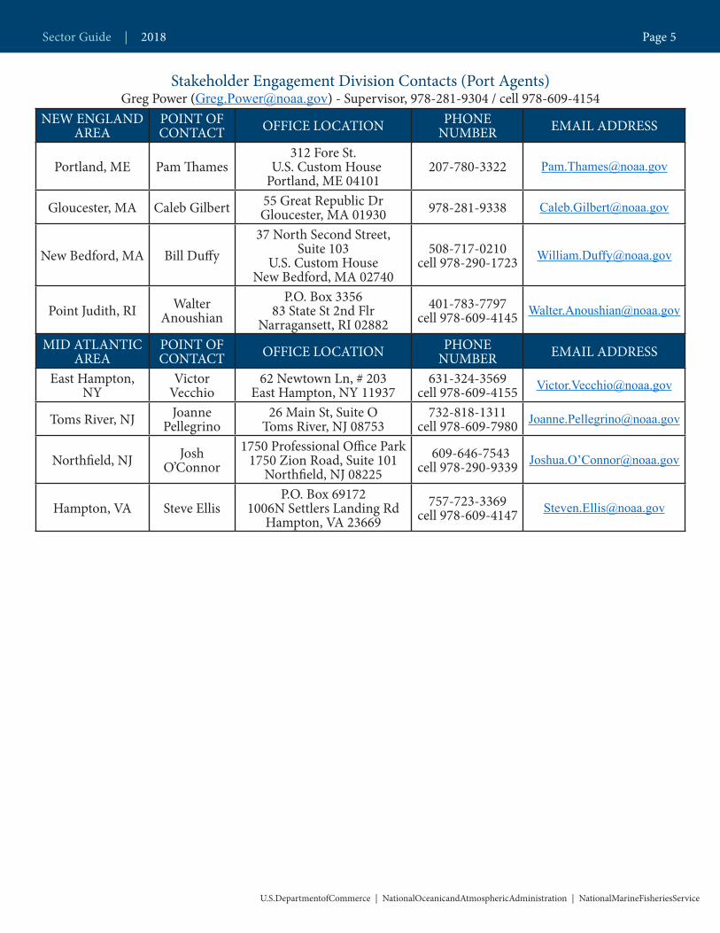
Stakeholder Engagement Division Contacts (Port Agents)Greg Power ([email protected]) - Supervisor, 978-281-9304 / cell 978-609-4154
NEW ENGLAND AREA
POINT OF CONTACT OFFICE LOCATION PHONE
NUMBER EMAIL ADDRESS
Portland, ME Pam Thames312 Fore St.
U.S. Custom House Portland, ME 04101
207-780-3322 [email protected]
Gloucester, MA Caleb Gilbert 55 Great Republic Dr Gloucester, MA 01930 978-281-9338 [email protected]
New Bedford, MA Bill Duffy37 North Second Street,
Suite 103U.S. Custom House
New Bedford, MA 02740
508-717-0210 cell 978-290-1723
Point Judith, RI Walter Anoushian
P.O. Box 3356 83 State St 2nd Flr
Narragansett, RI 02882401-783-7797
cell 978-609-4145 [email protected]
MID ATLANTIC AREA
POINT OF CONTACT OFFICE LOCATION PHONE
NUMBER EMAIL ADDRESS
East Hampton, NY
Victor Vecchio
62 Newtown Ln, # 203 East Hampton, NY 11937
631-324-3569 cell 978-609-4155 [email protected]
Toms River, NJ Joanne Pellegrino
26 Main St, Suite O Toms River, NJ 08753
732-818-1311 cell 978-609-7980 [email protected]
Northfield, NJ Josh O’Connor
1750 Professional Office Park1750 Zion Road, Suite 101
Northfield, NJ 08225 609-646-7543
cell 978-290-9339 Joshua.O’[email protected]
Hampton, VA Steve EllisP.O. Box 69172
1006N Settlers Landing Rd Hampton, VA 23669
757-723-3369 cell 978-609-4147 [email protected]
Sector Guide | 2018 Page 5
U.S.DepartmentofCommerce | NationalOceanicandAtmosphericAdministration | NationalMarineFisheriesService
U.S.DepartmentofCommerce | NationalOceanicandAtmosphericAdministration | NationalMarineFisheriesService
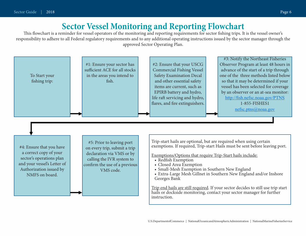
Sector Vessel Monitoring and Reporting FlowchartThis flowchart is a reminder for vessel operators of the monitoring and reporting requirements for sector fishing trips. It is the vessel owner’s
responsibility to adhere to all Federal regulatory requirements and to any additional operating instructions issued by the sector manager through the approved Sector Operating Plan.
#2: Ensure that your USCG Commercial Fishing Vessel Safety Examination Decal and other essential safety items are current, such as EPIRB battery and hydro,
life raft servicing and hydro, flares, and fire extinguishers.
#3: Notify the Northeast Fisheries Observer Program at least 48 hours in advance of the start of a trip through
one of the three methods listed below so that it may be determined if your vessel has been selected for coverage by an observer or an at-sea monitor:
http://fish.nefsc.noaa.gov/PTNS1-855-FISHES1
#4: Ensure that you have a correct copy of your
sector’s operations plan and your vessel’s Letter of Authorization issued by
NMFS on board.
#5: Prior to leaving port on every trip, submit a trip declaration via VMS or by calling the IVR system to
confirm the use of a previous VMS code.
Trip-start hails are optional, but are required when using certain exemptions. If required, Trip-start Hails must be sent before leaving port.
Exemptions/Options that require Trip-Start hails include:• Redfish Exemption • Closed Area Exemption• Small-Mesh Exemption in Southern New England • Extra-Large Mesh Gillnet in Southern New England and/or Inshore Georges Bank
Trip end hails are still required. If your sector decides to still use trip start hails or dockside monitoring, contact your sector manager for further instruction.
#1: Ensure your sector has sufficient ACE for all stocks in the areas you intend to
fish.To Start your fishing trip:
Sector Guide | 2018 Page 6
U.S.DepartmentofCommerce | NationalOceanicandAtmosphericAdministration | NationalMarineFisheriesService
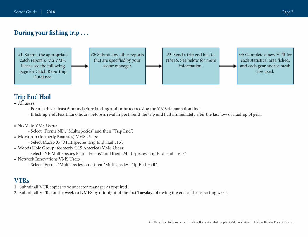
During your fishing trip . . .
Trip End Hail • All users: - For all trips at least 6 hours before landing and prior to crossing the VMS demarcation line. - If fishing ends less than 6 hours before arrival in port, send the trip end hail immediately after the last tow or hauling of gear.
• SkyMate VMS Users: - Select “Forms NE”, “Multispecies” and then “Trip End”. • McMurdo (formerly Boatracs) VMS Users: - Select Macro 37 “Multispecies Trip End Hail v15”. • Woods Hole Group (formerly CLS America) VMS Users: - Select “NE Multispecies Plan – Forms”, and then “Multispecies Trip End Hail – v15”• Network Innovations VMS Users: - Select “Form”, “Multispecies”, and then “Multispecies Trip End Hail”.
VTRs1. Submit all VTR copies to your sector manager as required. 2. Submit all VTRs for the week to NMFS by midnight of the first Tuesday following the end of the reporting week.
#1: Submit the appropriate catch report(s) via VMS. Please see the following
page for Catch Reporting Guidance.
#2: Submit any other reports that are specified by your
sector manager.
#3: Send a trip end hail to NMFS. See below for more
information.
#4: Complete a new VTR for each statistical area fished, and each gear and/or mesh
size used.
Sector Guide | 2018 Page 7
VMS Guidance for Sector Vessels Fishing Under the Redfish ExemptionExemption Description: Exemption from the requirement to use a minimum mesh size of 6.5-inch codend for trawl gear for red-fish trips.
Sectors may request an exemption to allow vessels to use a codend mesh as small as 5.5 inches on any approved trawl gear while fishing for Aca-dian redfish in the Redfish Exemption Area. The remaining portions of the trawl net must meet the 6.5-inch minimum mesh size. In order to fish under this exemption the vessel must be enrolled in an approved sector with this exemption. The vessel must have on board a valid copy of their sector letter of authorization that includes the exemption.
Vessels fishing this type of trip must send a Multispecies Trip Start Hail declaring the “Redfish Exemption” at the start of the trip and must submit daily VMS Multispecies Catch Reports documenting their catch. Vessels fishing under this exemption are not restricted to the Redfish Exemption Area while fishing with regulation gear. When the vessel is done fishing with regulation gear and is inside the Redfish Exemption Area, it must submit a VMS Multispecies Catch Report documenting its catch and indicating its intent to switch to below-regulation gear to target redfish. The vessel may then fish for redfish within the footprint of the Redfish Exemption Area. Once a vessel has declared its switch to below-regulation gear, it cannot re-deploy regulation gear and it cannot leave the Redfish Exemption Area.
The vessel must complete a separate vessel trip report (VTR) document-ing catch for each portion of the trip. The vessel must retain and land all legal-sized groundfish, even if it has the exemption listed above to discard legal-sized unmarketable fish, on both the regulated mesh and redfish portions of the trip and comply with all otherwise applicable regulatory requirements.
In summary, vessels fishing under the Redfish Exemption must submit the following VMS reports:
1. An Activity Declaration prior to leaving port on every trip; 2. A Multispecies Trip Start Hail declaring the “Redfish Exemption” prior to leaving port;3. A daily Multispecies Catch Report, due by 9am of the following day for every day of the trip;4. A Multispecies Catch Report immediately before switching to the smaller mesh portion of the trip and once inside the Redfish Exemption Area with a good faith estimate of all catch that day between 0000 hours
Questions Regarding Sector Exemptions?
VMS(978) 281-9213
Press 2 for VMS Line
Sector Guide | 2018 Page 8
U.S.DepartmentofCommerce | NationalOceanicandAtmosphericAdministration | NationalMarineFisheriesService

(12:00 AM) and the time of the report. The vessel must check the box stating, “If you declared a trip exemption or option in your Trip Start Hail that allows the use of smaller mesh and you intend to use smaller mesh immediately after sending this report, enter Y here”. This box should only be checked once per trip.5. A daily Multispecies Catch Report, due by 9am of the following day for every day of the trip; and6. A Multispecies Trip End Hail at least 6 hours before landing and prior to crossing the VMS demarcation line. If fishing ends less than 6 hours before arrival, send your report immediately after the last tow or hauling of gear.
Sector Guide | 2018 Page 9
U.S.DepartmentofCommerce | NationalOceanicandAtmosphericAdministration | NationalMarineFisheriesService

VMS Guidance for Sector Vessels Fishing Under the Small Mesh ExemptionExemption Description: Exemption from the requirement to use a minimum mesh size of 6.5-inch codend for trawl gear to target small-mesh species.
Sectors may request an exemption to allow vessels to target small-mesh species with small-mesh gear after targeting groundfish. In order to fish under this exemption the vessel must be enrolled in an approved sector with this exemption. The vessel must have on board a valid copy of their sector letter of authorization that includes the exemption.
Vessels fishing this type of trip must send a Multispecies Trip Start Hail declaring the “Small Mesh Exemption” at the start of the trip. Vessels fishing under this exemption are not restricted to the Sector Small-Mesh Exemption Area while fishing with standard-regulated groundfish gear. When the vessel is done fishing with standard-regulated groundfish gear and is inside the boundaries of the Sector Small-Mesh Exemption Area, it must submit a VMS Multispecies Catch Report documenting its catch for the first portion of the trip and indicating its intent to switch to small-mesh gear to target small-mesh species. The vessel may then fish for small-mesh species within the footprint of the Sector Small-Mesh Exemp-tion Area. Once a vessel has declared its switch to small-mesh gear, it cannot re-deploy standard-regulated groundfish gear and it must remain within the Sector Small-Mesh Exemption Area. Gear used to target small-mesh species must meet the gear requirements for that fishery.
The vessel must complete a separate vessel trip report (VTR) document-ing catch for each portion of the trip. The vessel must retain and land all legal-sized groundfish on both the standard-regulated mesh and small-mesh portions of the trip and comply with all otherwise applicable regula-tory requirements.
In summary, vessels fishing under the Redfish Exemption must submit the following VMS reports:
1. An Activity Declaration prior to leaving port on every trip;2. A Multispecies Trip Start Hail declaring the “Small Mesh Exemption” prior to leaving port;3. A Multispecies Catch Report immediately before switching to the smaller mesh portion of the trip and once inside the Sector Small-Mesh Exemption Area with a good faith estimate of all catch for the first por-
Questions Regarding Sector Exemptions?
VMS(978) 281-9213
Press 2 for VMS Line
Sector Guide | 2018 Page 10
U.S.DepartmentofCommerce | NationalOceanicandAtmosphericAdministration | NationalMarineFisheriesService

tion of the trip. The vessel must check the box stating, “If you declared a trip exemption or option in your Trip Start Hail that allows the use of smaller mesh and you intend to use smaller mesh immediately after sending this report, enter Y here”. This box should only be checked once per trip;4. A Multispecies Trip End Hail at least 6 hours before landing and prior to crossing the VMS demarcation line. If fishing ends less than 6 hours before arrival, send your report immediately after the last tow or hauling of gear; and5. A final Multispecies Catch Report.
Sector Guide | 2018 Page 11
U.S.DepartmentofCommerce | NationalOceanicandAtmosphericAdministration | NationalMarineFisheriesService
VMS Guidance for Vessels Fishing with Extra-Large Mesh Gillnets in Southern New England and Inshore Georges Bank Sector vessels fishing with extra-large mesh (ELM) gillnets (10 inches or greater) exclusively in the Southern New England (SNE) and Inshore Georges Bank (IGB) Broad Stock Areas are not subject to ASM require-ments. Vessels fishing this type of trip must send a Multispecies Trip Start Hail declaring the “Extra-Large Mesh Gillnet in SNE and/or IGB Option”. All other standard VMS reporting requirements still apply.
In summary, vessels fishing exclusively with 10-inch or larger ELM gillnets in the SNE and/or IGB broad stock areas must submit the following VMS reports:
1. An Activity Declaration prior to leaving port on every trip; 2. A Multispecies Trip Start Hail declaring the “Extra-Large Mesh Gill-net in SNE and/or IGB Option” prior to leaving port;3. A Multispecies Trip End Hail at least 6 hours before landing and prior to crossing the VMS demarcation line. If fishing ends less than 6 hours before arrival, send your report immediately after the last tow or hauling of gear; and4. A Multispecies Catch Report, if applicable.
VMS Guidance for Vessels Fishing with Extra-Large Mesh Gill-nets in Southern New England and Inshore Georges Bank AND Under the Sector Exemption from the Requirement to Fish Ex-clusively with 10-inch, or Larger, Mesh Gillnets to Target Dogfish on Trips Excluded from At-Sea Monitoring (ASM) Coverage
Sector vessels fishing with ELM gillnets (10 inches or greater) exclusively in the SNE and IGB Broad Stock Areas are not subject to ASM require-ments. Sectors may also request an exemption to allow vessels to target dogfish using 6.5-inch mesh gillnet gear within the footprint and season of either the Nantucket Shoals Dogfish Exemption Area (June 1 to Octo-ber 15), the Eastern Area of the Cape Cod Spiny Dogfish Exemption Area (June 1 to December 31), or the Southern New England Dogfish Gillnet Exemption Area (May 1 to October 31) on these non-ASM sector trips. In order to fish under this exemption the vessel must be enrolled in an ap-proved sector with the exemption. The vessel must have on board a valid
Questions Regarding Sector Exemptions?
VMS(978) 281-9213
Press 2 for VMS Line
Sector Guide | 2018 Page 12
U.S.DepartmentofCommerce | NationalOceanicandAtmosphericAdministration | NationalMarineFisheriesService
copy of their sector letter of authorization that includes the exemption.
Vessels fishing this type of trip may only fish with 10-inch or greater ELM gillnets during the first portion of the trip. When the vessel is done fishing with ELM gillnets, the vessel must submit a VMS Multispecies Catch Report documenting all catch and indicating its intent to switch to 6.5-inch mesh gillnets to target dogfish. The vessel may then deploy 6.5-inch mesh gillnet gear within the footprint and season of the existing dogfish exempted areas. When the vessel is done fishing for dogfish, the vessel must send a second VMS Multispecies Catch Report documenting all catch for the trip.
The vessel may not fish with ELM gillnet gear after declaring the switch to 6.5-inch mesh gillnets. The vessel must complete a separate vessel trip report (VTR) documenting catch for each portion of the trip. The vessel is required to retain and land all legal-sized groundfish while fishing this type of trip, consistent with sector regula-tions
In summary, vessels fishing with 10-inch or larger ELM gillnets in the SNE and/or IGB broad stock areas and using the Dogfish Exemption on the same trip must submit the following VMS reports:
1. An Activity Declaration prior to leaving port on every trip; 2. A Multispecies Trip Start Hail declaring the “Extra-Large Mesh Gillnet in SNE and/or IGB Option” prior to leaving port;3. A Multispecies Catch Report following completion of the ELM gillnet portion of the trip. The vessel must check the box stating, “If you declared a trip exemption or option in your Trip Start Hail that allows the use of smaller mesh and you intend to use smaller mesh immediately after sending this report, enter Y here”;4. A Multispecies Trip End Hail at least 6 hours before landing and prior to crossing the VMS demarcation line. If fishing ends less than 6 hours before arrival, send your report immediately after the last tow or hauling of gear; and5. A Multispecies Catch Report for all catch on board at the end of the trip and prior to crossing the VMS demarcation line.
Sector Guide | 2018 Page 13
U.S.DepartmentofCommerce | NationalOceanicandAtmosphericAdministration | NationalMarineFisheriesService
Catch Reporting GuidanceTrip Level ReportingUnless otherwise required below, limited access Sector vessels declared into a single broad stock area (BSA) no longer need to submit a vessel monitoring system (VMS) trip level catch report on the return to port prior to crossing the demarcation line. We are implementing thischange to remove reporting redundancies and streamline requirements.
Daily ReportingVessels on a groundfish trip (sector or common pool) must still submit daily or trip-level VMS catch reports if the vessel has declared into: 1) Multiple BSAs; 2) the Eastern US/Canada area; or 3) sector exemption(s) or option(s) with catch reporting requirements. See page 15 below for more information.
All other VMS reporting requirements still apply, including the require-ment to send:1) An activity Declaration prior to leaving port on every trip;2) A Trip Start Hail prior to leaving port if declaring a sector exemption or option; and3) A Trip End Hail at least 6 hours prior to arrival or, if fishing ends less than 6 hours before arrival, immediately after the last tow or hauling of gear.
Sector Guide | 2018 Page 14
U.S.DepartmentofCommerce | NationalOceanicandAtmosphericAdministration | NationalMarineFisheriesService
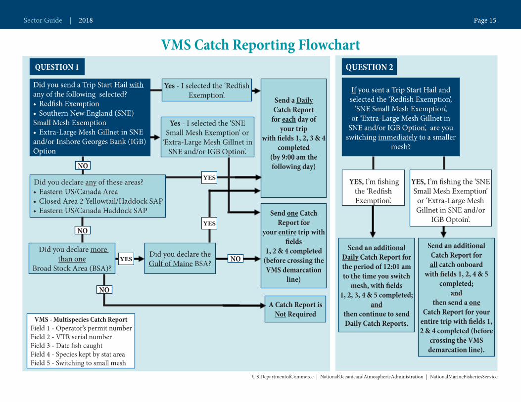
VMS Catch Reporting Flowchart
U.S.DepartmentofCommerce | NationalOceanicandAtmosphericAdministration | NationalMarineFisheriesService
VMS - Multispecies Catch Report Field 1 - Operator’s permit number Field 2 - VTR serial number Field 3 - Date fish caught Field 4 - Species kept by stat area Field 5 - Switching to small mesh
Send one Catch Report for
your entire trip with fields
1, 2 & 4 completed (before crossing the VMS demarcation
line)
Send a Daily Catch Report
for each day of your trip
with fields 1, 2, 3 & 4 completed
(by 9:00 am the following day)
QUESTION 1
Did you send a Trip Start Hail with any of the following selected? • Redfish Exemption• Southern New England (SNE) Small Mesh Exemption• Extra-Large Mesh Gillnet in SNE and/or Inshore Georges Bank (IGB) Option
Did you declare any of these areas?• Eastern US/Canada Area • Closed Area 2 Yellowtail/Haddock SAP• Eastern US/Canada Haddock SAP
Did you declare more than one
Broad Stock Area (BSA)?
Did you declare the Gulf of Maine BSA?
NO
NO
QUESTION 2
If you sent a Trip Start Hail and selected the ‘Redfish Exemption’,
‘SNE Small Mesh Exemption’, or ‘Extra-Large Mesh Gillnet in
SNE and/or IGB Option’, are you switching immediately to a smaller
mesh?
YES, I’m fishing the ‘Redfish Exemption’.
YES, I’m fishing the ‘SNE Small Mesh Exemption’
or ‘Extra-Large Mesh Gillnet in SNE and/or
IGB Optoin’.
Send an additional Daily Catch Report for the period of 12:01 am to the time you switch
mesh, with fields 1, 2, 3, 4 & 5 completed;
andthen continue to send Daily Catch Reports.
YES
YES
Send an additional Catch Report for all catch onboard
with fields 1, 2, 4 & 5 completed;
and then send a one
Catch Report for your entire trip with fields 1, 2 & 4 completed (before
crossing the VMS demarcation line).
Yes - I selected the ‘Redfish Exemption’.
Yes - I selected the ‘SNE Small Mesh Exemption’ or
‘Extra-Large Mesh Gillnet in SNE and/or IGB Option’.
YES
A Catch Report is Not Required
NO
NO
Sector Guide | 2018 Page 15
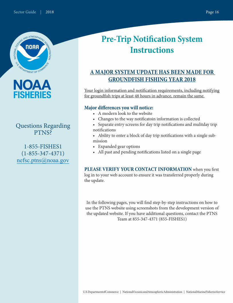
Pre-Trip Notification System Instructions
A MAJOR SYSTEM UPDATE HAS BEEN MADE FOR GROUNDFISH FISHING YEAR 2018
Your login information and notification requirements, including notifying for groundfish trips at least 48 hours in advance, remain the same.
Major differences you will notice:• A modern look to the website• Changes to the way notificatoin information is collected • Separate entry screens for day trip notifications and mulitday trip notifications• Ability to enter a block of day trip notifications with a single sub-mission• Expanded gear options • All past and pending notifications listed on a single page
PLEASE VERIFY YOUR CONTACT INFORMATION when you first log in to your web account to ensure it was transferred properly during the update.
In the following pages, you will find step-by-step instructions on how to use the PTNS website using screenshots from the development version of the updated website. If you have additional questions, contact the PTNS
Team at 855-347-4371 (855-FISHES1)
Questions Regarding PTNS?
1-855-FISHES1(1-855-347-4371)
Sector Guide | 2018 Page 16
U.S.DepartmentofCommerce | NationalOceanicandAtmosphericAdministration | NationalMarineFisheriesService

Logging In
To log into your PTNS web account:1. Navigate your browser to http://fish.nefsc.noaa.gov/PTNS. This is the same URL as the original PTNS website.2. Enter your vessel permit number as your username.3. Enter your FishOnline PIN as your password.4. Click the LOG IN button.
If you forget your password, you will not be able to reset it from the login screen. You must call staff at the Greater Atlantic Regional Fisheries Office at 978-281-9188 to retrieve or reset your password. The PTNS Team will still be able to access your account during this time; you may contact them at 855-347-4371 if you need to use your PTNS account.
Northeast Enforcement Division | 2018 Page 17
U.S. Department of Commerce | National Oceanic and Atmospheric Administration | National Marine Fisheries Service
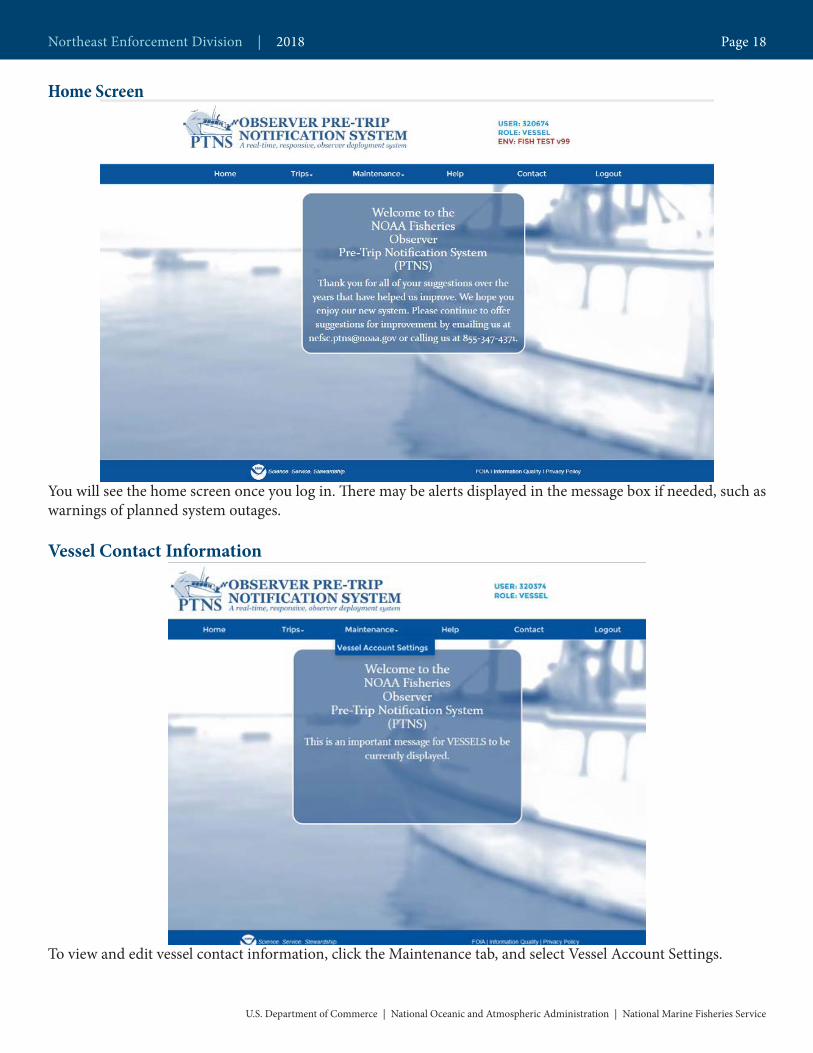
Home Screen
You will see the home screen once you log in. There may be alerts displayed in the message box if needed, such as warnings of planned system outages.
Vessel Contact Information
To view and edit vessel contact information, click the Maintenance tab, and select Vessel Account Settings.
Northeast Enforcement Division | 2018 Page 18
U.S. Department of Commerce | National Oceanic and Atmospheric Administration | National Marine Fisheries Service
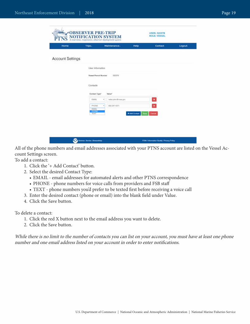
All of the phone numbers and email addresses associated with your PTNS account are listed on the Vessel Ac-count Settings screen.To add a contact:
1. Click the ‘+ Add Contact’ button.2. Select the desired Contact Type:
• EMAIL - email addresses for automated alerts and other PTNS correspondence• PHONE - phone numbers for voice calls from providers and FSB staff• TEXT - phone numbers you’d prefer to be texted first before receiving a voice call
3. Enter the desired contact (phone or email) into the blank field under Value.4. Click the Save button.
To delete a contact:1. Click the red X button next to the email address you want to delete.2. Click the Save button.
While there is no limit to the number of contacts you can list on your account, you must have at least one phone number and one email address listed on your account in order to enter notifications.
Northeast Enforcement Division | 2018 Page 19
U.S. Department of Commerce | National Oceanic and Atmospheric Administration | National Marine Fisheries Service
Entering New Notifications
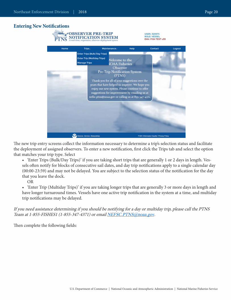
The new trip entry screens collect the information necessary to determine a trip’s selection status and facilitate the deployment of assigned observers. To enter a new notification, first click the Trips tab and select the option that matches your trip type. Select
• ‘Enter Trips (Bulk/Day Trips)’ if you are taking short trips that are generally 1 or 2 days in length. Ves-sels often notify for blocks of consecutive sail dates, and day trip notifications apply to a single calendar day (00:00-23:59) and may not be delayed. You are subject to the selection status of the notification for the day that you leave the dock.
OR• ‘Enter Trip (Multiday Trips)’ if you are taking longer trips that are generally 3 or more days in length and have longer turnaround times. Vessels have one active trip notification in the system at a time, and multiday trip notifications may be delayed.
If you need assistance determining if you should be notifying for a day or multiday trip, please call the PTNS Team at 1-855-FISHES1 (1-855-347-4371) or email [email protected].
Then complete the following fields:
Northeast Enforcement Division | 2018 Page 20
U.S. Department of Commerce | National Oceanic and Atmospheric Administration | National Marine Fisheries Service
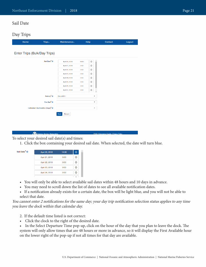
Sail Date
Day Trips
To select your desired sail date(s) and times:1. Click the box containing your desired sail date. When selected, the date will turn blue.
• You will only be able to select available sail dates within 48 hours and 10 days in advance. • You may need to scroll down the list of dates to see all available notification dates.• If a notification already exists for a certain date, the box will be light blue, and you will not be able to select that date.
You cannot enter 2 notifications for the same day; your day trip notification selection status applies to any time you leave the dock within that calendar day.
2. If the default time listed is not correct:• Click the clock to the right of the desired date.• In the Select Departure Time pop-up, click on the hour of the day that you plan to leave the dock. The system will only allow times that are 48 hours or more in advance, so it will display the First Available hour on the lower right of the pop-up if not all times for that day are available.
Northeast Enforcement Division | 2018 Page 21
U.S. Department of Commerce | National Oceanic and Atmospheric Administration | National Marine Fisheries Service

• Click your desired sail minute in the Select Departure Time pop-up.
4. Repeat this step until all your desired dates are selected and highlighted blue.
To deselect a sail date, click the box containing that date. The box will no longer be highlighted blue and a notifi-cation will not be submitted for that date.
In order to enter notifications in bulk, they must all have the same trip characteristics. For instance, if you plan to make a set-only trip, you must enter that notification separately.
Multiday Trips
To select your desired sail date and times:
Northeast Enforcement Division | 2018 Page 22
U.S. Department of Commerce | National Oceanic and Atmospheric Administration | National Marine Fisheries Service
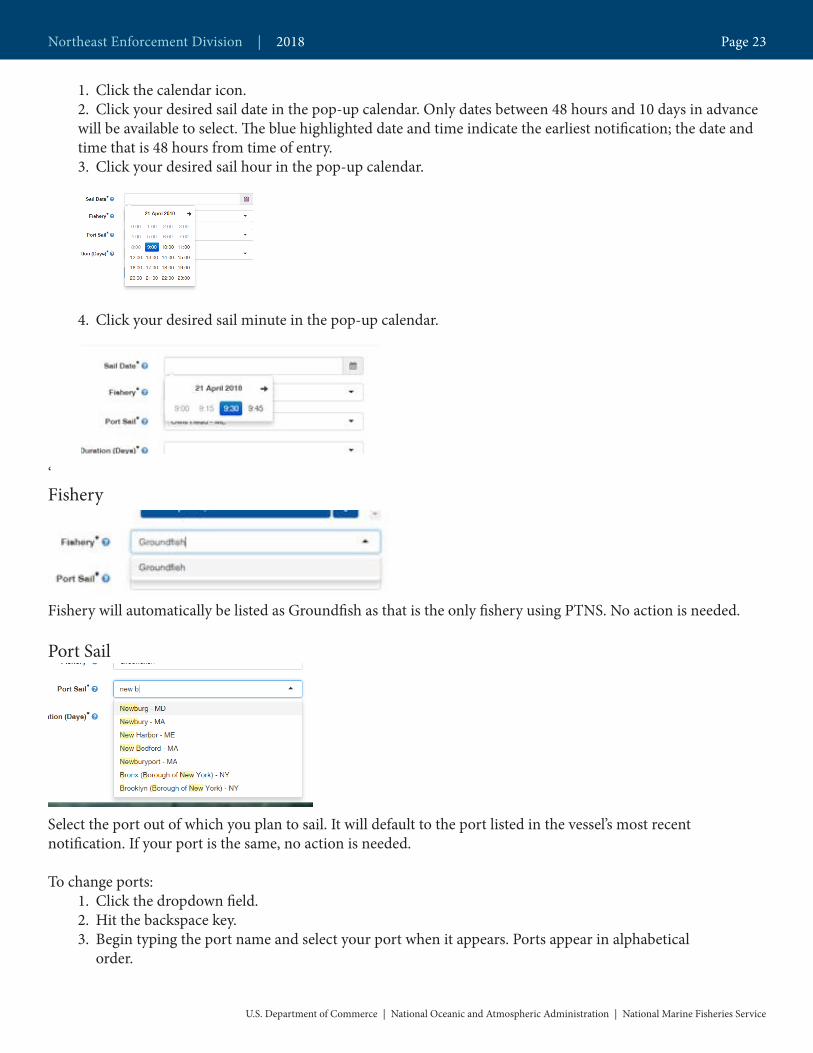
1. Click the calendar icon.2. Click your desired sail date in the pop-up calendar. Only dates between 48 hours and 10 days in advance will be available to select. The blue highlighted date and time indicate the earliest notification; the date and time that is 48 hours from time of entry.3. Click your desired sail hour in the pop-up calendar.
4. Click your desired sail minute in the pop-up calendar.
‘Fishery
Fishery will automatically be listed as Groundfish as that is the only fishery using PTNS. No action is needed.
Port Sail
Select the port out of which you plan to sail. It will default to the port listed in the vessel’s most recentnotification. If your port is the same, no action is needed.
To change ports:1. Click the dropdown field.2. Hit the backspace key.3. Begin typing the port name and select your port when it appears. Ports appear in alphabetical
order.
Northeast Enforcement Division | 2018 Page 23
U.S. Department of Commerce | National Oceanic and Atmospheric Administration | National Marine Fisheries Service

Estimated Trip Duration (Days)
Select the length of your trip, rounded to days. It will default to the estimated trip duration in the vessel’s most recent notification. If your trip duration is the same, no action is needed. You will be able to select a length of 1 or 2 days in the day trip entry screen and 3 – 13 days in the multiday trip entry screen. If you do not see the trip length you desire, you may need to switch from entering a day trip notification to a multiday trip notification or vice versa. Use the ‘Trips’ tab to change between the notification entry pages. As a reminder, these trip types have different rules. Contact the PTNS Coordinators if you need assistance determining if you should be entering day trips or multiday trips.
The screenshot on the right is the Estimated Trip Duration page from day trip entry, multiday is on the left.
Help text
Each field has a small blue question mark next to it. These question marks open a description of the field require-ments and any helpful information associated with that field. Please contact the PTNS coordinators with any suggestions to change this text to make it as helpful as possible.
Northeast Enforcement Division | 2018 Page 24
U.S. Department of Commerce | National Oceanic and Atmospheric Administration | National Marine Fisheries Service
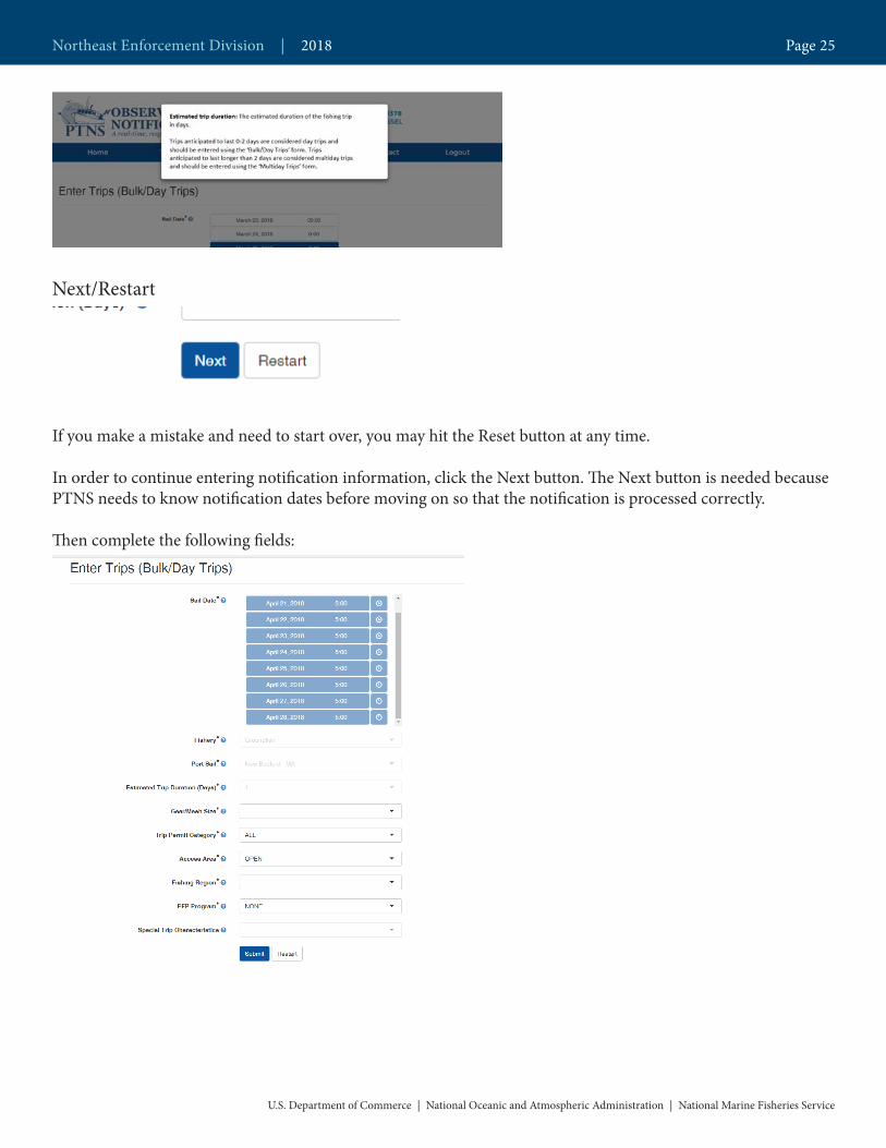
Next/Restart
If you make a mistake and need to start over, you may hit the Reset button at any time.
In order to continue entering notification information, click the Next button. The Next button is needed because PTNS needs to know notification dates before moving on so that the notification is processed correctly.
Then complete the following fields:
Northeast Enforcement Division | 2018 Page 25
U.S. Department of Commerce | National Oceanic and Atmospheric Administration | National Marine Fisheries Service
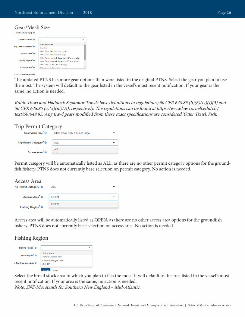
Gear/Mesh Size
The updated PTNS has more gear options than were listed in the original PTNS. Select the gear you plan to use the most. The system will default to the gear listed in the vessel’s most recent notification. If your gear is the same, no action is needed.
Ruhle Trawl and Haddock Separator Trawls have definitions in regulations; 50 CFR 648.85 (b)(6)(iv)(J)(3) and 50 CFR 648.85 (a)(3)(iii)(A), respectively. The regulations can be found at https://www.law.cornell.edu/cfr/text/50/648.85. Any trawl gears modified from these exact specifications are considered ‘Otter Trawl, Fish’.
Trip Permit Category
Permit category will be automatically listed as ALL, as there are no other permit category options for the ground-fish fishery. PTNS does not currently base selection on permit category. No action is needed.
Access Area
Access area will be automatically listed as OPEN, as there are no other access area options for the groundfish fishery. PTNS does not currently base selection on access area. No action is needed.
Fishing Region
Select the broad stock area in which you plan to fish the most. It will default to the area listed in the vessel’s most recent notification. If your area is the same, no action is needed.Note: SNE-MA stands for Southern New England – Mid-Atlantic.
Northeast Enforcement Division | 2018 Page 26
U.S. Department of Commerce | National Oceanic and Atmospheric Administration | National Marine Fisheries Service
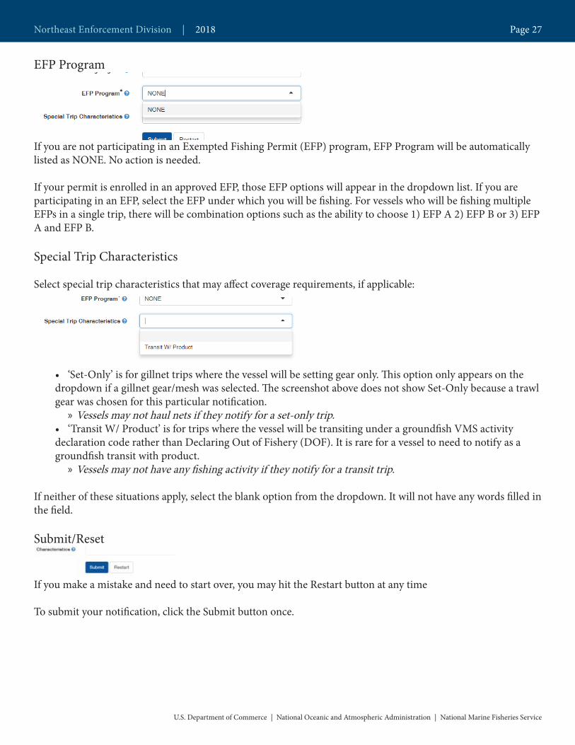
EFP Program
If you are not participating in an Exempted Fishing Permit (EFP) program, EFP Program will be automatically listed as NONE. No action is needed.
If your permit is enrolled in an approved EFP, those EFP options will appear in the dropdown list. If you are participating in an EFP, select the EFP under which you will be fishing. For vessels who will be fishing multiple EFPs in a single trip, there will be combination options such as the ability to choose 1) EFP A 2) EFP B or 3) EFP A and EFP B.
Special Trip Characteristics
Select special trip characteristics that may affect coverage requirements, if applicable:
• ‘Set-Only’ is for gillnet trips where the vessel will be setting gear only. This option only appears on the dropdown if a gillnet gear/mesh was selected. The screenshot above does not show Set-Only because a trawl gear was chosen for this particular notification.
» Vessels may not haul nets if they notify for a set-only trip.• ‘Transit W/ Product’ is for trips where the vessel will be transiting under a groundfish VMS activity declaration code rather than Declaring Out of Fishery (DOF). It is rare for a vessel to need to notify as a groundfish transit with product.
» Vessels may not have any fishing activity if they notify for a transit trip.
If neither of these situations apply, select the blank option from the dropdown. It will not have any words filled in the field.
Submit/Reset
If you make a mistake and need to start over, you may hit the Restart button at any time
To submit your notification, click the Submit button once.
Northeast Enforcement Division | 2018 Page 27
U.S. Department of Commerce | National Oceanic and Atmospheric Administration | National Marine Fisheries Service
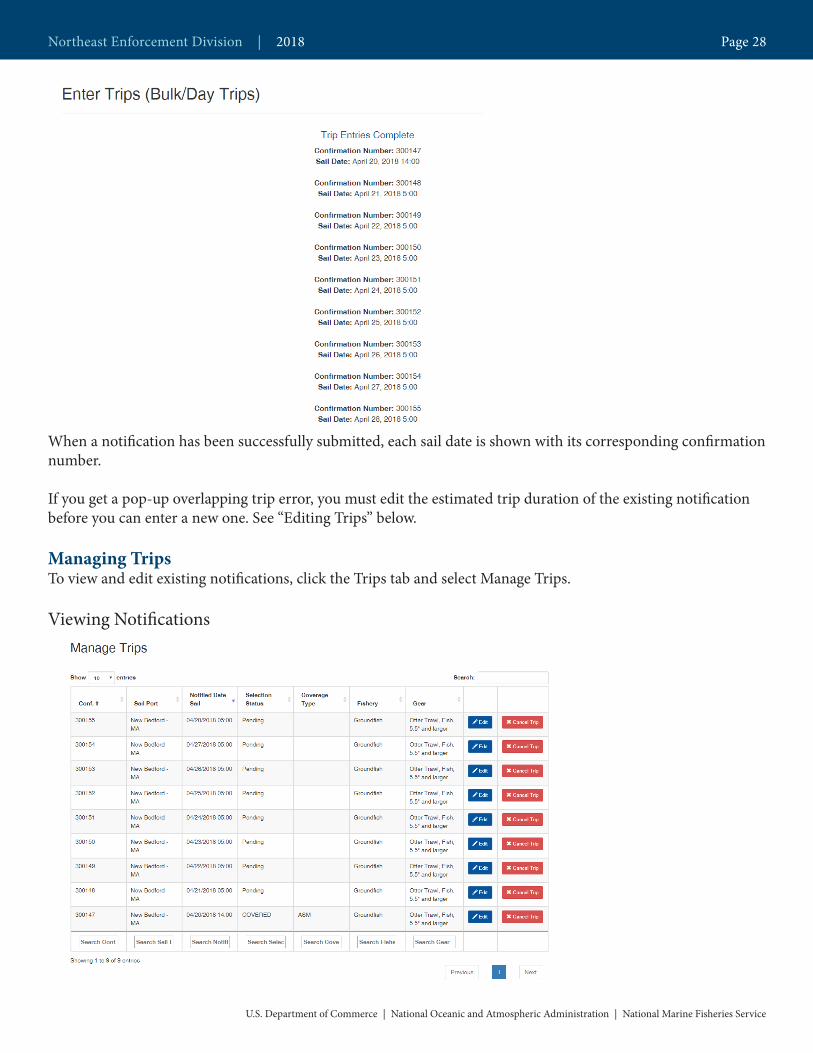
When a notification has been successfully submitted, each sail date is shown with its corresponding confirmation number.
If you get a pop-up overlapping trip error, you must edit the estimated trip duration of the existing notification before you can enter a new one. See “Editing Trips” below.
Managing TripsTo view and edit existing notifications, click the Trips tab and select Manage Trips.
Viewing Notifications
Northeast Enforcement Division | 2018 Page 28
U.S. Department of Commerce | National Oceanic and Atmospheric Administration | National Marine Fisheries Service

In the Manage Trips screen, you will be able to view all of your notifications. The confirmation number, sail port, sail date, observer assignment status, coverage type (if applicable), fishery, and gear for each notification will be visible in the list.
To choose how many notifications are displayed on a page, click the ‘Show Entries’ dropdown in the top left of the page, and select the number of notifications you would like to see on one page.
To search all fields in all of your notifications, begin typing in the search box to the upper right. To search an individual field, begin typing in the search box at the bottom of the column.
To order your notifications by a specific field, click the up or down arrows by the field name.
To view additional information on an individual notification, click the ‘Edit’ button. After viewing the Editing page, you can return to your list of notifications by clicking the ‘Back to Manage Trips’ button.
The Selection Status field currently has the following statuses. These are subject to change and/or renaming soon after the initial rollout of the new system.
• ‘Pending’ is for notifications > 48 hours from the current time• ‘COVERED’ has two meanings. 1) Notification was preliminarily selected by the PTNS, but the trip is currently being offered to the provider, or 2) the provider accepted the trip and has an observer available. The COVERED notification could change to ‘Waiver’ if the provider is not able to cover the trip. Note, PTNS emails will be sent for final selection status only.• ‘Waiver’ means that the vessel can sail without an observer under that notification• ‘Complete’ indicates that that trip already sailed with an observer• ‘Canceled’ notifications are ones that did not sail. Vessels may not sail on groundfish trips under canceled notifications.
Editing Notifications
Northeast Enforcement Division | 2018 Page 29
U.S. Department of Commerce | National Oceanic and Atmospheric Administration | National Marine Fisheries Service

To edit a notification:1. Click the ‘Edit’ button for the trip you want to change.2. Change your desired fields.3. Click the ‘Submit’ button.
When a notification has been successfully edited, the sail date will be shown with its corresponding confirmation number.
To clear unsaved changes and start over, you may click the Restart button at any time. To clear unsaved changes and return to your notification list, click the ‘Back to Manage Trips’ button.
Not all fields can be changed by a vessel. PTNS Coordinators may edit more fields. If you are having trouble edit-ing your trip, contact the PTNS Team at 1-855-347-4371.
Canceling Notifications
To cancel a notification:1. Click the Cancel Trip button.2. Select a Cancel Reason from the dropdown in the Cancel Trip pop-up.3. Click the Save button.
Northeast Enforcement Division | 2018 Page 30
U.S. Department of Commerce | National Oceanic and Atmospheric Administration | National Marine Fisheries Service

If you do not want to cancel the notification, click the Cancel button in the Cancel Trip pop-up to return to your notification list.
You may not sail on a groundfish trip without a matching active notification in PTNS. If you have canceled your trip in error or otherwise need to reinstate it, contact the PTNS Team at 1-855-347-4371.
Getting AssistanceYou can find answers to many of your questions in various areas of the PTNS.
Enter Trips Screen
Each field has a small blue question mark next to it. These question marks open a description of the field require-ments and any helpful information associated with that field. Please contact the PTNS coordinators with any suggestions to change this text to make it as helpful as possible.
Northeast Enforcement Division | 2018 Page 31
U.S. Department of Commerce | National Oceanic and Atmospheric Administration | National Marine Fisheries Service

Help Screen
To access the PTNS vessel instructions, FAQ, and other useful information, click the Help tab and click on the document you wish to open.
Contact Screen
To find contact information for PTNS-related questions, click the Contact tab.
Northeast Enforcement Division | 2018 Page 32
U.S. Department of Commerce | National Oceanic and Atmospheric Administration | National Marine Fisheries Service
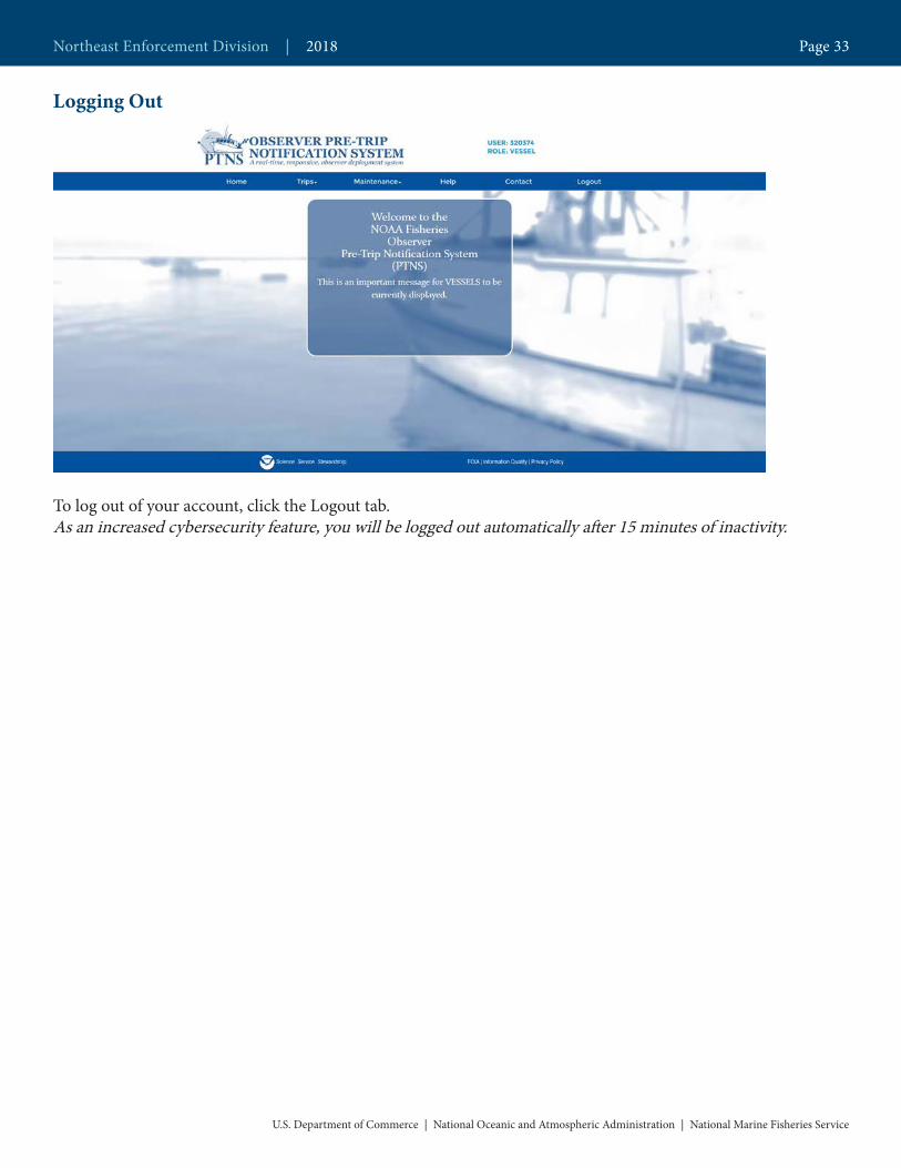
Logging Out
To log out of your account, click the Logout tab.As an increased cybersecurity feature, you will be logged out automatically after 15 minutes of inactivity.
Northeast Enforcement Division | 2018 Page 33
U.S. Department of Commerce | National Oceanic and Atmospheric Administration | National Marine Fisheries Service
Industry Funded At-Sea Monitor Duties: What to expect during a
monitored tripMonitors shall perform the following duties, at a minimum:
• Conduct a pre-trip safety inspection.• Ask the captain and/or owner of the vessel for some economic information, such as trip costs (price of fuel, ice, etc.), dealer, and VTR number.• Collect information on fishing gear, such as size of nets, mesh sizes, and gear configurations. • Collect tow-by-tow information, such as wave height and location, and time when fishing begins and ends. • Record all kept and discarded catch (fish, sharks, crustaceans, invertebrates, and debris) on observed hauls and record kept catch on unobserved hauls, which includes species, weight, and reason kept or discarded. • Collect actual weights of catch whenever possible, or estimate or extrapolate weights by sub-sampling. • Collect length frequencies of kept and discarded catch. • Collect detailed information on interactions with protected species, such as sea turtles, porpoise, dolphins, whales, and birds (also called incidental takes).
Monitors should not:
• Provide advice about fishing regulations.• Accept any gifts or direct payment in any form from the vessel operator, owner, or crew. • Participate in commercial fishing activities during the trip, such as dressing fish, or standing wheel watch. • Hinder or slow fishing operations unless necessary to obtain critical discard or incidental take information. • Use personal recording devices, such as camcorders, cameras, cell phones, and diaries. • Use the vessel’s communication equipment for personal purposes. • Discuss the observed trip with anyone other than program staff. • Handle the EPRIB in any manner, including removing housing.
Sector Guide | 2018 Page 34
U.S.DepartmentofCommerce | NationalOceanicandAtmosphericAdministration | NationalMarineFisheriesService

The Captain’s legal responsibilities include, but are not limited to:
• Ensure the vessel has a current U.S. Coast Guard Commercial Fishing Vessel Safety Examination decal and other essential non-expired safety devices, provide the monitor with a safety orientation, and maintain a wheel watch throughout the trip.• Provide the monitor with living quarters, meals, and amenities comparable to a crew member. • Allow the monitor access to areas of the vessel and gear necessary to conduct their duties. • Assist the monitor in obtaining EPRIB expiration dates mandatory for the Pre-Trip Vessel Safety Checklist.• Allow the monitor access to communication and navigation equipment as necessary to perform their duties. • Provide true vessel locations by latitude and longitude upon request by the monitor. • Provide the monitor with VTR Serial Numbers.• Notify the monitor when commercial fishing operations are to begin and end. • Bring aboard marine mammals, sea turtles and sea birds that were killed during fishing operations if requested by the monitor. • Provide refrigerated storage space for monitor-collected specimens within reason.
It is illegal for Captains and Crew to:
• Assault, harass or sexually harass, intimidate or attempt to influence monitors. • Interfere with or impede monitor duties.• Ask monitors to stand watch or help with fishing operations.• Fish without a monitor on board the vessel after the owner or agent of the owner has been selected by NMFS to carry a monitor.
Monitors should bring the following, along with other scientific gear:
C.P.R. Card, personal identification, and proof of insurance; immersion suit and Personal Floatation Device; appropriate clothing, such as boots, raingear, gloves; length frequency boar for finfish; spring scales; scientific calipers and tape measures; buckets and/or baskets to sample; and work-issued cameras, logs, manuals, and field guides.
At the completion of a trip, Monitors should provide the Captain with the following:
• Data release Form to request of photocopy of the monitor’s trip logs.• Fisherman’s Comment Card with pre-paid postage.
Sector Guide | 2018 Page 35
U.S.DepartmentofCommerce | NationalOceanicandAtmosphericAdministration | NationalMarineFisheriesService

Vessel Trip Reporting (VTR)Overview
VTR Requirements by Vessel Permit TypePermits Frequency of reporting Reporting DeadlineIf a vessel is issued a Party/Charter permit for:• Summer Flounder• Scup • Black sea bass• Bluefish• Squid/Atlantic mavkerel/Butterfish• Tilefish
Then the owner/operator must electronically submit trip reports withing 48 hours of landing for all Party/Charter trips reglardless of species targeted.
Reports must be electronically submitted using an approved eVTR reporting application withing 48 hours of landing.
If a vessel is issued a permit for:• Atlantic herring• Altantic mackerel• Illex squid• Longfin squid/butterfish• Northeast multispecies• Ocean quahogs• Surfclams . . .
Then the owner/operator must submit
trip reports weekly
Reports must be postmarked or received by
midnight of the Tuesday following the reporting week (Sunday through
Saturday). If a trip starts in one week, and offloads in the next, it should be reported in the
week the catch was offloaded.
If a vessel is issued a permit for:• Atlantic bluefish• Atlantic deep-sea red crab• Atlantic sea scallop• Black sea bass• Monkfish• Northeast skate• Scup• Spiny dogfish• Summer flounder• Tilefish . . .
Then the owner/operator must submit trip reports monthly
Reports must be postmarked or
received within 15 days of the end of
the month. If a trip starts in one month, and offloads in the next, it should be reported for the
month in which the catch was offloaded.
If a vessel is issued a permit for American lobster and no other Greater Atlantic Region vessel permit . . .
Then the owner/operator is not
required to submit trip reports (check with
your state, which may require reporting).
N/A
Questions Regarding VTRs?
Vessel Trip Report Office(978) 281-9246
Sector Guide | 2018 Page 36
U.S.DepartmentofCommerce | NationalOceanicandAtmosphericAdministration | NationalMarineFisheriesService
Defining fishing trip activity that requires VTRIf your vessel is issued any of the fishery permits with reporting requirements shown in the table above, you are required to complete a VTR for every fishing trip, whether the vessel is fishing in state or federal waters, or in another region of the country, such as Gulf of Mexico. This is true for all trips, no matter what species is being fished for or caught. Having an observer or at-sea monitor on board during a trip does not relieve you from this requirement.
These instructions clarify that a VTR is required for any trip on a federally permitted vessel when you catch fish, or when your operations include activities that would support fishing, such as preparing to catch or harvest fish, or attempting to catch or harvest fish. All such fishing activities must be reported, even if no landings are made. The trip is the period of time during which these activities are conducted, beginning when the vessel leaves port and ending when the vessel returns to port.
You are required to report fishing trips even if no fish are caught or onboard if the following events occur:
• If you begin a fishing trip, but must return to port before setting or retrieving gear because of issues like bad weather or mechanical problems, then you must still complete a VTR. In this case, you must complete the in-formation in VTR Fields 1-6, along with fields 24027, and enter “No Effort” in the lower portion of the VTR. • If you make a fishing trip just to set out gear you must still complete a VTR. Complete the information in VTR fields 1-6, along with fields 24-27, and enter “Set Only” in the lower portion of the VTR.• If you make an unsuccessful trip, and don’t catch any fish, you must still complete a VTR. In this case, you must complete all of the trip information in VTR Fields 1-16, and enter “No Catch” or “NC” in the species code field (#17).
There are several instances where a VTR isn’t required for a specific trip:• If you are transiting without any product onboard and don’t engage in any fishing activity. For example, you’re moving your vessel to a shipyard or you’re returning to your home port. • If you are operating under a scientific Letter of Acknowledgement. • If you are operating as a Herring Carrier Vessel.
When to complete and submit more than one VTR pageYou must complete all of the fields on a new VTR page each time you change your fishing area or gear. This means a new page is required each time you:
• Change the chart area (inshore or offshore) in which you are fishing;• Change the type of gear you are using; or• Change the mesh size or ring size in the gear you are using.
New gear codes VTR Field #7 requires you to identify the type of gear you used. New codes have been added to the gear code table so that we can get better information about fishing gears. The scallop dredge codes are critical for evaluat-ing the effectiveness of scallop dredge gear modifications for reducing interactions with sea turtles. The codes are summarized below:
• DRS - this code should be used for the standard scallop dredge• DSC - this code should be used for the standard scallop dredge with chain mat • DTS - this new code should be used for the scallop turtle deflector dredge
Sector Guide | 2018 Page 37
U.S.DepartmentofCommerce | NationalOceanicandAtmosphericAdministration | NationalMarineFisheriesService

• DTC- ths new code should be used for the scallop turtle deflector dredge with chain mat • OTT- this code should be used for otter trawls (OTF) that are joined together in a “Twin Trawl” configura-tion. A “Twin Trawl” refers to two nets that are joined together in the middle.• TTS - this code should be used from otter trawls, shrimp (OTS) that are joined together in a “Twin Trawl” configuration. A “Twin Trawl” refers to two nets that are joined together in the middle.
How to report when you fish in more than one chart areaIf your fishing activity occurs in more than one chart area, you must submit a VTR for each chart area whereyou started to haul back or retrieve gear. If your tow or the placement of your fixed gear (for example, gillnets)crosses chart area boundaries, the area you report must be the area you were in when you started to retrieve orhaul back your gear. For the gear types shown in the gear code table on page 9, this means:
• For mobile gear (trawl gears and dredges), you report the area where the hauling equipment is put into gear with the intention of hauling back and retrieving a net or dredge;• For fixed gear (gillnets, longline, pots, traps, and weirs) you report the area where the hauling equipment is put into gear or retrieval of one end of the set begins.• For purse seine gear, and other seine gears, you report the area where the skiff hits the water upon setting the gear, or when the first piece of gear hits the water, whichever occurs first.• For handline, rod and reel, and the gears listed as “other gears”, you report the area where the gear is completely retrieved and aboard the vessel.
For example, if you start a tow in chart area 522, start hauling back in area 525, and land 100 pounds ofmonkfish, then all the catch from this tow would be reported in chart area 525.
Protected SpeciesYou must report all species caught (both kept and discarded), including all protected species. To report seaturtles or ESA-listed fish species (e.g., Atlantic salmon or sturgeon) incidentally caught, injured, or killed, enterthe species code for each turtle or fish under the species code name column (#17) on the VTR. Enter the actualnumber (count) of sea turtles or listed fish caught in the discard column (#19). Under the dealer name column(#21), comment on the condition of the sea turtles or listed fish (e.g., alive, injured, or dead).
When an incidental mortality or injury of a marine mammal (seals, dolphins, porpoises, and whales) occursduring commercial fishing activities, you must also fill out and return the Marine Mammal AuthorizationProgram Mortality & Injury Reporting Form within 48 hours of returning from the trip on which the incidentoccurred. You may obtain additional information, including a reporting form, by visiting :http://www.nmfs.noaa.gov/pr/interactions/mmap/ or call 978-281-9328.
The National Marine Fisheries Service requires vessel trip information for the conservation and management of marine fishery resources in accordance with the Magnuson-Stevens Fishery Conservation and Management Act. The data reported will be used to develop, implement, and monitor fishery management strategies and for a vari-ety of other uses. Submission is mandatory for those persons falling under the requirements of 50 CFR 648.7 (b). All data submitted will be handled as Confidential material in accordance with NOAA Administrative Orders. Public reporting burden for the survey is estimated to average 5 minutes per response, including the time for reviewing instructions, searching existing data sources, gathering and maintaining the data needed, and com-pleting and reviewing the collection of information. Send comments regarding this burden estimate or any other aspect of this collection of information, including suggestions for reducing this burden, to NOAA Fisheries, 55 Great Republic Drive, Gloucester, MA 01930.
Sector Guide | 2018 Page 38
U.S.DepartmentofCommerce | NationalOceanicandAtmosphericAdministration | NationalMarineFisheriesService
Notwithstanding any other provision of the law, no person is required to respond to, nor shall any person be sub-ject to a penalty for failure to comply with, a collection of information subject to the requirements of the Paper-work Reduction Act, unless that collection of information displays a currently valid OMB Control Number.
Privacy Act StatementAuthority: The collection of this information is authorized under the Magnuson-Stevens Fishery Conservation and Management Act, 16 U.S.C 1801 et seq..
Purpose: The Magnuson-Stevens Act requires that conservation and management measures must prevent over fishing while achieving, on a continuing basis, the optimum yield from each fishery. Vessel logbooks are essential tools in the management of fishery resources. Section 303(a)(5) of the Magnuson-Stevens Act specifically identi-fies the kinds of data to be collected for fishery management plans (FMPs).
Routine Uses: The Department will use this information for effective fishery management. Disclosure of this in-formation is permitted under the Privacy Act of 1974 (5 U.S.C. Section 552a), to be shared within NMFS offices, in order to coordinate monitoring and management of sustainability of fisheries and protected resources, as well as with the applicable State or Regional Marine Fisheries Commissions and International Organizations. Dis-closure of this information is also subject to all of the published routine uses as identified in the COMMERCE/NOAA-6, Fishermen’s Statistical Data.
Disclosure: Submission is mandatory for those persons falling under the requirements of 50 CFR 648.7 (b). If the information is not provided, permit status may be affected.
Sector Guide | 2018 Page 39
U.S.DepartmentofCommerce | NationalOceanicandAtmosphericAdministration | NationalMarineFisheriesService
Questions Regarding VTRs?
Vessel Trip Report Office(978) 281-9246
Vessel Trip Reporting (VTR)Frequently Asked Questions
Question: If I change gear type, mesh size, or chart area fished during a trip, how do I complete my VTR?Answer: Complete a separate report for any change in gear type, mesh/ring size or chart area.
Question: Do I have to complete a report if I am going out just to set gear?Answer: Yes. If you make a fishing trip just to set out gear you must still complete a VTR. Complete the information in VTR fields 1-6, along with fields 24-27, and enter “Set Only” in the lower portion of the VTR.
Question: Do I have to complete a report if I return to port prior to engaging in any fishing activity (e.g.,mechanical breakdown, bad weather)?Answer: Yes. If you begin a fishing trip, but must return to port before setting or retrieving gear because of issues like bad weather or mechanical problems, then you must still complete a VTR. In this case, you must complete the information in VTR Fields 1-6, along with fields 24-27, and enter “No Effort” in the lower portion of the VTR.
Question: Do I have to complete a report if I’m using my federally permitted vessel to fish recreationally?Answer: Yes. Federally permitted vessels must report every trip that they take. Recreational trips which use a federally permitted vessel require a VTR to be filled out and submitted. All of the sections, including species caught and\or discarded, are to be filled out. The only difference in how you would fill out a VTR for a recreational trip involves boxes 20 and 21. For Box 20, Dealer Permit Number, enter ‘99998’ (the code for home consumption) and leave Box 21, Dealer Name, blank.
Question: What if I don’t land any fish on a trip?Answer: If during fishing operations no species are caught (kept or discarded), you must still complete a VTR. In this case, you must complete all of the trip information in VTR Fields 1-16, and enter “No Catch” or “NC” in the species code field (#17).
Sector Guide | 2018 Page 40
U.S.DepartmentofCommerce | NationalOceanicandAtmosphericAdministration | NationalMarineFisheriesService

Question: If I send in several reports at one time, do I have to sign and date every report?Answer: Yes. All VTRs must be signed and dated or they will be returned to you for completion.
Question: Do I have to give my VTR serial number to the dealer(s) that I sold my catch to?Answer: Yes. You are required to provide the VTR serial number to each Federal dealer to whom you sell your catch. If your trip required you to fill out more than one VTR page please provide the dealer with the first VTR that you filled out for the trip.
Question: I gave the wrong VTR serial number to my dealer. Can I alter the serial number on my VTR tomatch the number I gave my dealer?Answer: No. The serial number is a preprinted unique number and must not be altered or the VTR will bereturned to you. Contact your dealer(s) to have them correct their dealer reports.
Question: My supply of VTRs is getting low. How do I get more?Answer: VTRs can be obtained by mailing the renewal form contained in each VTR packet to the NMFSaddress below. You may also obtain VTRs by contacting the NMFS Vessel Trip Reporting Office, either in person, or by telephone at (978) 281-9157 or by contacting your local NMFS Field Office.
NOAA FisheriesVessel Trip Reporting Office55 Great Republic DriveGloucester, MA 01930-2276
Question: How long am I required to keep copies of my VTRs?Answer: VTRs and any records upon which the reports were based must be kept on board the vessel for atleast one year and retained by the owner/operator for a total of three years after the date of the last entry on the report.
Question: If I’m fishing outside of the Greater Atlantic Region (e.g. in the Gulf of Mexico or off the coastof Florida or on the High Seas for Tuna) do I have to submit VTRs?Answer: Yes. If your vessel is issued a permit from the Greater Atlantic region you are required to submit a VTR to us regardless of where the fishing activity took place or the species targeted. The one exception to this is for vessels that are only permitted for American Lobster.
Sector Guide | 2018 Page 41
U.S.DepartmentofCommerce | NationalOceanicandAtmosphericAdministration | NationalMarineFisheriesService
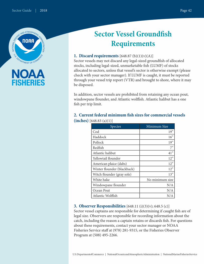
Sector Vessel Groundfish Requirements
1. Discard requirements [648.87 (b)(1)(v)(A)]Sector vessels may not discard any legal-sized groundfish of allocated stocks, including legal-sized, unmarketable fish (LUMF) of stocks allocated to sectors, unless that vessel’s sector is otherwise exempt (please check with your sector manager). If LUMF is caught, it must be reported through your vessel trip report (VTR) and brought to shore, where it may be disposed.
In addition, sector vessels are prohibited from retaining any ocean pout, windowpane flounder, and Atlantic wolffish. Atlantic halibut has a one fish per trip limit.
2. Current federal minimum fish sizes for commercial vessels (inches) [648.83 (a)(1)]
Species Minimum Size Cod 19”Haddock 16”Pollock 19”Redfish 7”Atlantic halibut 41”Yellowtail flounder 12”American plaice (dabs) 12”Winter flounder (blackback) 12”Witch flounder (gray sole) 13”White hake No minimum sizeWindowpane flounder N/AOcean Pout N/AAtlantic Wolffish N/A
3. Observer Responsibilities [648.11 (i)(3)(v); 648.5 (c)]Sector vessel captains are responsible for determining if caught fish are of legal size. Observers are responsible for recording information about the catch, including the reason a captain retains or discards fish. For questions about these requirements, contact your sector manager or NOAA Fisheries Service staff at (978) 281-9315, or the Fisheries Observer Program at (508) 495-2266.
Sector Guide | 2018 Page 42
U.S.DepartmentofCommerce | NationalOceanicandAtmosphericAdministration | NationalMarineFisheriesService
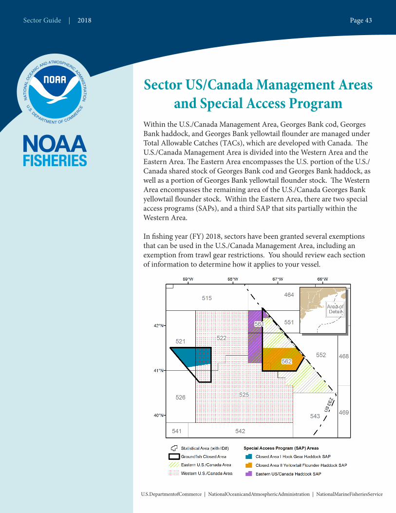
Sector US/Canada Management Areas and Special Access Program
Within the U.S./Canada Management Area, Georges Bank cod, Georges Bank haddock, and Georges Bank yellowtail flounder are managed under Total Allowable Catches (TACs), which are developed with Canada. The U.S./Canada Management Area is divided into the Western Area and the Eastern Area. The Eastern Area encompasses the U.S. portion of the U.S./Canada shared stock of Georges Bank cod and Georges Bank haddock, as well as a portion of Georges Bank yellowtail flounder stock. The Western Area encompasses the remaining area of the U.S./Canada Georges Bank yellowtail flounder stock. Within the Eastern Area, there are two special access programs (SAPs), and a third SAP that sits partially within the Western Area.
In fishing year (FY) 2018, sectors have been granted several exemptions that can be used in the U.S./Canada Management Area, including an exemption from trawl gear restrictions. You should review each section of information to determine how it applies to your vessel.
Sector Guide | 2018 Page 43
U.S.DepartmentofCommerce | NationalOceanicandAtmosphericAdministration | NationalMarineFisheriesService
General Requirements of the U.S./Canada Management Area
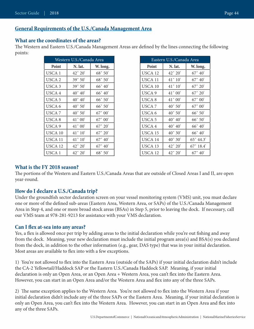
What are the coordinates of the areas?The Western and Eastern U.S./Canada Management Areas are defined by the lines connecting the following points:
What is the FY 2018 season? The portions of the Western and Eastern U.S./Canada Areas that are outside of Closed Areas I and II, are open year-round.
How do I declare a U.S./Canada trip?Under the groundfish sector declaration screen on your vessel monitoring system (VMS) unit, you must declare one or more of the defined sub-areas (Eastern Area, Western Area, or SAPs) of the U.S./Canada Management Area in Step 4, and one or more broad stock areas (BSAs) in Step 5, prior to leaving the dock. If necessary, call our VMS team at 978-281-9213 for assistance with your VMS declaration.
Can I flex at-sea into any areas?Yes, a flex is allowed once per trip by adding areas to the initial declaration while you’re out fishing and away from the dock. Meaning, your new declaration must include the initial program area(s) and BSA(s) you declared from the dock, in addition to the other information (e.g., gear, DAS type) that was in your initial declaration. Most areas are available to flex into with a few exceptions.
1) You’re not allowed to flex into the Eastern Area (outside of the SAPs) if your initial declaration didn’t include the CA-2 Yellowtail/Haddock SAP or the Eastern U.S./Canada Haddock SAP. Meaning, if your initial declaration is only an Open Area, or an Open Area + Western Area, you can’t flex into the Eastern Area. However, you can start in an Open Area and/or the Western Area and flex into any of the three SAPs.
2) The same exception applies to the Western Area. You’re not allowed to flex into the Western Area if your initial declaration didn’t include any of the three SAPs or the Eastern Area. Meaning, if your initial declaration is only an Open Area, you can’t flex into the Western Area. However, you can start in an Open Area and flex into any of the three SAPs.
Western U.S./Canada Area Point N. lat. W. long.
USCA 1 42˚ 20' 68˚ 50'USCA 2 39˚ 50' 68˚ 50'USCA 3 39˚ 50' 66˚ 40'USCA 4 40˚ 40' 66˚ 40'USCA 5 40˚ 40' 66˚ 50'USCA 6 40˚ 50' 66˚ 50'USCA 7 40˚ 50' 67˚ 00'USCA 8 41˚ 00' 67˚ 00'USCA 9 41˚ 00' 67˚ 20'USCA 10 41˚ 10' 67˚ 20'USCA 11 41˚ 10' 67˚ 40'USCA 12 42˚ 20' 67˚ 40'USCA 1 42˚ 20' 68˚ 50'
Eastern U.S./Canada Area Point N. lat. W. long.
USCA 12 42˚ 20' 67˚ 40'USCA 11 41˚ 10' 67˚ 40'USCA 10 41˚ 10' 67˚ 20'USCA 9 41˚ 00' 67˚ 20'USCA 8 41˚ 00' 67˚ 00'USCA 7 40˚ 50' 67˚ 00'USCA 6 40˚ 50' 66˚ 50'USCA 5 40˚ 40' 66˚ 50'USCA 4 40˚ 40' 66˚ 40'USCA 15 40˚ 30' 66˚ 40'USCA 14 40˚ 30' 65˚ 44.3'USCA 13 42˚ 20' 67˚ 18.4'USCA 12 42˚ 20' 67˚ 40'
Sector Guide | 2018 Page 44
U.S.DepartmentofCommerce | NationalOceanicandAtmosphericAdministration | NationalMarineFisheriesService
What are the VMS reporting requirements after I declare into the Eastern Area? If you’re declared into the Eastern Area, including the CA-2 Yellowtail/Haddock SAP or the Eastern U.S./Canada Haddock SAP, you must submit a daily catch report via VMS. The report must be submitted by 9AM the following day and include all fields. You must enter each chart area fished under Step 4 on the form, and report all groundfish and non-groundfish kept.
If you do not declare the Eastern Area from the dock, and instead use the sector exemption to declare the CA-2 Yellowtail/Haddock SAP or the Eastern U.S./Canada Haddock SAP while at sea (known as flexing), you are required to submit a report indicating all of your catch from that trip up until the time you declared into the SAPs. Once you’ve declared into either of these SAPs, you must submit daily reports for the remainder of the trip. Vessels that declare their intent to fish within and outside of the Gulf of Maine Broad Stock Area on the same trip must submit daily VMS catch reports for the duration of the trip.
What are the VMS reporting requirements if I do NOT declare into the Eastern Area?If you’re declared into the Western Area only and do not flex at sea into either of the Eastern Area SAPs, a VMS catch report is not required. If you declared into more than one broad stock area (not including the Gulf of Maine), then you are required to submit a trip-level catch report. If you declared into more than one broad stock area (including the Gulf of Maine), then you are required to submit daily catch reports.
What are my Vessel trip report (VTR) requirements?If your fishing activity occurs in more than one chart area, you must submit a VTR for each chart area where you started to haul back or retrieve gear. If your tow or the placement of your fixed gear (for example, gillnets) crosses chart area boundaries, the area you report must be the area you were in when you started to retrieve or haul back your gear.
How are my VTRs and VMS catch reports used for catch attribution?We use the chart areas reported on VMS catch reports and VTRs to apportion catch to specific stock allocations. For example, cod caught in chart area 562 is attributed to Eastern Area cod, while cod caught from chart area 515 is attributed to Gulf of Maine cod.
Do I have groundfish landing limits?You remain exempt from trip limits for most ground-fish species, however, you are allowed one halibut per trip, and may not possess Atlantic wolffish, ocean pout, or windowpane flounder.
What are my gear restrictions this year?Because of a sector exemption, you may use all approved gear types that are allowed in the GB Regulated Mesh Area (RMA). None of the window-pane flounder AM areas are in effect in FY 2018.
Do I get a DAS credit for fishing only in the Eastern Area?Yes, if you declare and fish exclusively in the Eastern Area, your DAS are charged only for the time inside the area. If you fish inside and outside of the Eastern Area on the same trip, DAS are charged normal.
Eastern U.S./Canada Area Haddock SAP:What are the coordinates of the areas?The Eastern U.S./Canada Haddock SAP Area is defined by lines connecting the following points, in order:
Point N. lat. W. long.1 42˚ 22’ 67˚ 20’2 42˚ 20’ 67˚ 20’3 42˚ 20’ 67˚ 40’4 41˚ 10’ 67˚ 40’5 41˚ 10’ 67˚ 20’6 42˚ 10’ 67˚ 20’7 42˚ 10’ 67˚ 10’1 42˚ 22’ 67˚ 20’
Sector Guide | 2018 Page 45
U.S.DepartmentofCommerce | NationalOceanicandAtmosphericAdministration | NationalMarineFisheriesService
What is the FY 2018 season? The Eastern U.S./Canada Haddock SAP is open May 1 through December 31.
What are my gear restrictions this year?You may use all approved gear types that are allowed in the GB RMA.
Closed Area II Yellowtail Flounder/Haddock SAP:What are the coordinates of the areas?The CA II Yellowtail Flounder/Haddock SAP is defined by lines connecting the following points in the order listed:
What is the FY 2018 season? The CA II Yellowtail Flounder/Haddock SAP is open May 1 through January 31.
What are my gear restrictions this year?With the exception of a flounder trawl, you may use all approved gear types that are allowed in the GB RMA.
Point N. lat. W. long.1 41˚ 30’ 67˚ 20'2 41˚ 30' 66˚ 34.8'3 41˚ 18.6' 66˚ 24.8'4 41˚ 00’ 66˚ 35.8'5 41˚ 00’ 67˚ 20'1 41˚ 30’ 67˚ 20'
Sector Guide | 2018 Page 46
U.S.DepartmentofCommerce | NationalOceanicandAtmosphericAdministration | NationalMarineFisheriesService
Gear DefinitionsHaddock separator trawl: A haddock separator trawl is defined as a groundfish trawl modified to a vertically oriented trouser trawl configuration, with two extensions arranged one over the other, where a codend is attached only to the upper extension, and the bottom extension is left open and does not have a codend at-tached. A horizontal large-mesh separating panel constructed with a minimum of 6.0-inch diamond mesh must be installed between the selvedges joining the upper and lower panels, extending forward from the front of the trouser junction to the aft edge of the first belly behind the fishing circle. Effective October 31, 2016, the hori-zontal large-mesh separating panel must be constructed with mesh of a contrasting color to the upper and bottom extensions of the net that it separates.
Either a two-seam or a four-seam bottom trawl net may be used, provided they meet the requirements below.
• Two-seam bottom trawl nets: For two-seam nets, the separator panel must be constructed such that the width of the forward edge of the panel is 80-85 percent of the width of the after edge of the first belly of the net where the panel is attached. For example, if the belly is 200 meshes wide (from selvedge to selvedge), the separa-tor panel must be no wider than 160-170 meshes wide.
• Four-seam bottom trawl nets: For four-seam nets, the separator panel must be constructed such that the width of the forward edge of the panel is 90-95 percent of the width of the after edge of the first belly of the net where the panel is attached. For example, if the belly is 200 meshes wide (from selvedge to selvedge), the separa-tor panel must be no wider than 180-190 meshes. The separator panel must be attached to both of the side pan-els of the net along the midpoint of the side panels. For example, if the side panel is 100 meshes tall, the separa-tor panel must be attached at the 50th mesh.
Ruhle trawl: A Ruhle trawl is defined as a four-seam bottom groundfish trawl with large meshes in the forward panels, reducing in size toward the trawl’s codend. All meshes in the forward panels, except for the square and square side panels, must measure at least 7.9 ft. The square and square side panel meshes, and those panel meshes immediately aft of the fishing circle, must measure at least 31.5 inches. The first bottom belly must contain meshes measuring at least 7.9 ft. The second bottom belly meshes must measure at least 31.5 inches. All remaining panels must contain meshes measuring at least 7.9-inches. For complete construction parameters, including fishing circle, sweep, and kite requirements, please see § 648.85(b)(6)(iv)(J)(3).
Flounder trawl: A flounder trawl net is defined as bottom trawl gear meeting one of the following net descriptions:
• A two-seam, low-rise net constructed with 6-inch diamond mesh or 6.5-inch square mesh, where the maximum footrope length is not greater than 105 ft and the headrope is at least 30 percent longer than the footrope. The footrope and headrope lengths shall be measured from the forward wing end. The codend must be either 6.5-inch diamond or 6.5-inch square mesh.
• A two-seam, low-rise net constructed with 6-inch diamond mesh or 6.5-inch square mesh, with the exception that the top panel of the net contains a section of mesh at least 10 ft long and stretching from selvedge to selvedge, composed of at least 12–inch mesh that is inserted no farther than 4.5 meshes behind the headrope. The codend must be either 6.5-inch diamond or 6.5-inch square mesh.
Sector Guide | 2018 Page 47
U.S.DepartmentofCommerce | NationalOceanicandAtmosphericAdministration | NationalMarineFisheriesService
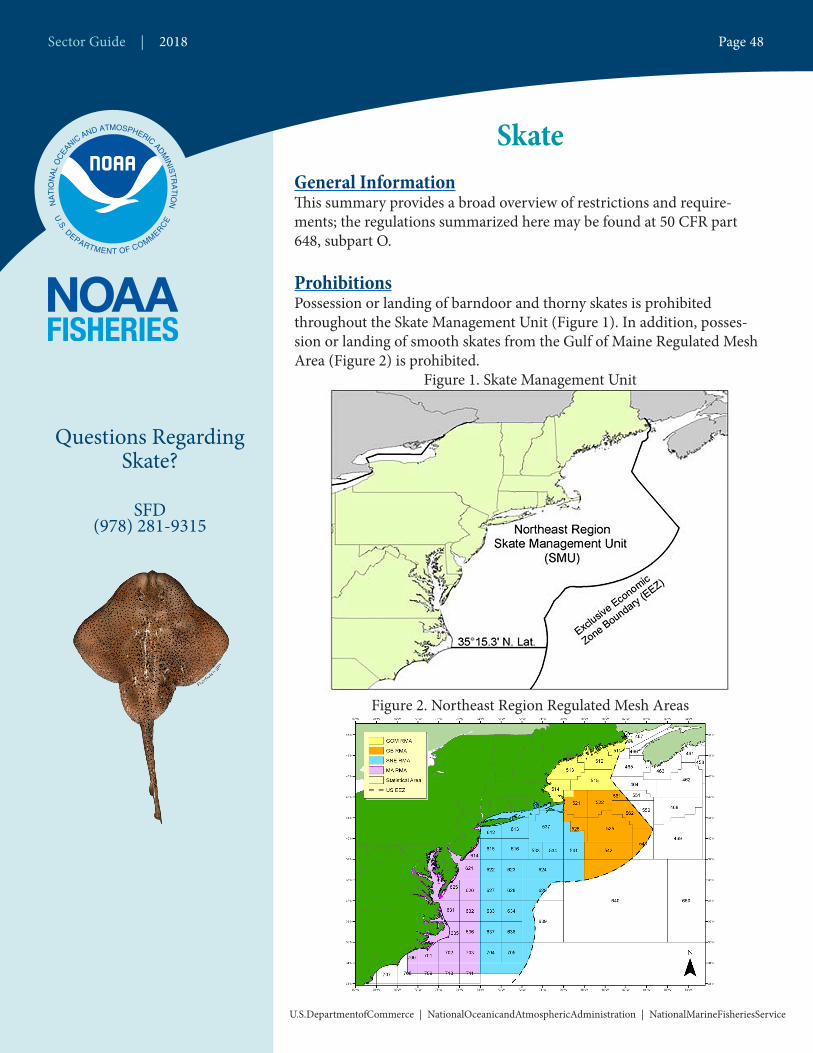
SkateGeneral InformationThis summary provides a broad overview of restrictions and require-ments; the regulations summarized here may be found at 50 CFR part 648, subpart O.
ProhibitionsPossession or landing of barndoor and thorny skates is prohibited throughout the Skate Management Unit (Figure 1). In addition, posses-sion or landing of smooth skates from the Gulf of Maine Regulated Mesh Area (Figure 2) is prohibited.
Figure 1. Skate Management Unit
Figure 2. Northeast Region Regulated Mesh Areas
Questions Regarding Skate?
SFD(978) 281-9315
Sector Guide | 2018 Page 48
U.S.DepartmentofCommerce | NationalOceanicandAtmosphericAdministration | NationalMarineFisheriesService
What Federal Permits are available for skates?An open access commercial skate permit is required to possess, land, or sell skates. To obtain a permit application, contact our Permits Office at http://www.greateratlantic.fisheries.noaa.gov/aps/permits/ Or call (978) 281-9370.
How are skate allowable landings allocated?Each fishing year (May 1-April 30), the skate wing fishery is allocated 66.5 percent of the Federal total landings (TAL) for skates, and the skate bait fishery is allocated 33.5 percent of the Federal TAL.
What are the skate wing fishery possession limits?Vessels fishing on a NE multispecies “A”, scallop, or monkfish days-at-sea (DAS) may possess and land:
• 2,600 lb of skate wings (5,902 lb whole weight) per trip from May 1 to August 31; and• 4,100 lb of skate wings (9,307 lb whole weight) per trip from September 1 to April 30 (Table 1).
Vessels fishing on a NE multispecies category “B” DAS (regardless of gear type) may only possess 220 lb of skate wings (500 lb whole weight).
A vessel not fishing in any DAS program, includ-ing sector vessels, may possess and land an incidental limit of 500 lb of skate wings (1,135 lb whole weight) per trip, as long as the vessel possesses a valid skate permit. A sector vessel that lands the higher trip limit described above must use a DAS.
What is the in season adjustment of wing possession limits?When 85 percent of the Skate Wing TAL is projected to be landed between May 1 and August 17, the skate wing possession limit will be reduced to the incidental limit of 500 lb of skate wings (1,135 lb whole weight) for all vessels for the remainder of Season 1. If 85 percent of the skate wing TAL is projected to be landed any time be-tween August 18 and April 30, the Regional Administrator may reduce the possession limit to prevent overfish-ing from occuring.
Which forms of skate are allowed in the skate fishery?Vessels may possess and land skate wings, skate carcasses, and/or whole skates. The weight of skate carcasses may not exceed 1.27 times the weight of skate wings, and vessels may not possess skate carcasses without retaining the associated wings. Any combination of landed skate products must adhere to the trip limits described above.
What are the NE Multispecies DAS exemption programs in the skate fishery?If you are fishing for skate wings, there are no DAS exemption programs and you must be fishing on a DAS in order to possess and land more than the incidental limit of 500 lb of skate wings (1,135 lb whole weight).
If you are fishing for skate bait, and possess a Skate Bait Letter of Authorization (LOA), you do not have to be on a DAS to possess more than the incidental limit of 500 lb of skate wings (1,135 whole weight) in the Mid Atlantic Exemption Area as well as the skate exemption areas in Southern New England.
Table 1. Skate Possession Limits during Open Fishing Seasons
Trip Limit (lb)Skate
WingsWhole Skates
NE Multispecies, Scallop, or Monkfish DAS
May 1 - Aug 31 2,600 5,902
Sept 1 - April 30 4,100 9,307
NE Multispecies B DAS May 1- April 30 220 500
Non-DAS May 1 - April 30 500 1,135
Skate Bait LOAMay 1 - Oct 31 0 25,000
Nov 1 - April 30 0 12,000Note: Conversion factor from wing to whole weight is 2.27.
Sector Guide | 2018 Page 49
U.S.DepartmentofCommerce | NationalOceanicandAtmosphericAdministration | NationalMarineFisheriesService

If you are fishing in a NE multispecies DAS exemption program that permits skate retention, without a Skate Bait LOA, you may possess and land skate or skate parts equal to 10 percent, by weight, of all other species on board, or 500 lb of skate wings (1,135 lb whole weight), whichever is less. Additional information on the NE multispecies DAS exemption programs can be found at: http://www.greateratlantic.fisheries.noaa.gov/sustain-able/species/multispecies/.
What is a Skate Bait LOA?A Federal skate permit holder may request from NMFS an exemption from the skate wing possession limits described above to land whole skates for use as bait (Table 1). The LOA can be obtained from the Permits Office at (978) 282-8438 or online here.
If you have a Skate Bait LOA, you must follow these requirements:• Possession/landing of only whole skates less than 23 inches total length;• Must be fishing on a NE multispecies, monkfish, or scallop DAS unless fishing in one of the skate exemp-tion areas;• Compliance with bait fishery possession limits;• Compliance with the at-sea transfer provisions, if applicable (see below); and,• Enrollment for at least 7 days.
The Skate Bait LOA does not exempt the participating vessel from DAS requirements of the NE multispecies, monkfish, or scallop fisheries, unless fishing in a DAS exemption program as described above.
What are the skate bait fishery seasons and possession limits?The Skate Bait TAL is divided into three seasons to help maintain a supply of bait throughout the fish-ing year (Table 2).
What is the inseason adjust-ment of bait possession limit?When 90 percent of the seasonal quota is landed in either Season 1 or 2, or when 80 percent of the annual Skate Bait TAL is landed, the skate bait possession limit will be reduced to the incidental limit of 8,000 lb. If 100 per-cent of the Skate Bait TAL is landed, the skate bait fishery will be closed, and active LOAs will be voided
Can I transfer skate bait at sea?Yes. A vessel issued a Federal skate permit may transfer skates at sea, provided: • The transferring vessel has an LOA onboard (see above);• The transferring vessel maintains a record of the quantity of skates transferred according to the current vessel trip report (VTR) reporting requirements;• The transferring vessel provides the receiving vessel documentation showing the date and amount of skates transferred, regardless of monetary exchange; and• The transferring vessel maintains onboard, for at least 1 year from the date of the transfer, a copy of the docu-mentation.
Table 2. Skate Bait Fishery SeasonsSeason Percentage of Skate Bait TAL Possession Limit (lb)
1 May 1–July 31 30.825,000
2 August 1–October 31 37.13 November 1–April 30 Remainder of Skate Bait TAL 12,000
Figure 3. Recently approved skate bait exemption area. Season: July 1 - October 31.
Sector Guide | 2018 Page 50
U.S.DepartmentofCommerce | NationalOceanicandAtmosphericAdministration | NationalMarineFisheriesService
Questions Regarding Spiny Dogfish?
SFD(978) 281-9315
Spiny DogfishGeneral InformationThis summary provides a broad overview of restrictions and require-ments; the regulations summarized here may be found at 50 CFR part 648, subpart L.
What Federal permits are available for dogfish?An open access commercial dogfish permit is required to possess, land, or sell dogfish. To obtain a permit application, contact our Permits Office at http://www.greateratlantic.fisheries.noaa.gov/aps/permits/index.html or (978) 281-9370.
What are the permit requirements for dogfish?In order to possess dogfish in Federal waters, you must have a Federal dogfish permit, and you must also be fishing under one of the following conditions:
• A NE multispecies trip (including day-at-sea (DAS), B DAS, non-DAS sector, Handgear A and B);• A scallop DAS; • A monkfish-only DAS (if fishing in a monkfish exemption area as defined in the large mesh information sheet found at http://www.nero.noaa.gov/nero/regs/infodocs/Large_mesh_exemption.pdf; or• An exempted fishery (see Tables 2 and 3).
Any catch of allocated groundfish stocks by a NE multispecies sector vessel while targeting spiny dogfish will count against its sector’s annual catch entitlement, unless the vessel is fishing in an exempted fishery or with exempted gear outside of the DAS program.
How is the quota allocated and managed in Federal waters?The quota is established annually based upon the estimated size of the dogfish population and sustainable harvest rates. In Federal waters, the quota is allocated coastwide for the fishing year May 1 – April 30. All spiny dogfish landings, whether from Federal or state waters, are counted toward that quota and monitored by NMFS. When the annual quota is fully harvested, the dogfish fishery will be closed for the remainder of the fishing year. Commercial landings are not permitted following a closure announcement. Weekly landings reports are available at http://www.greateratlantic.fisheries.noaa.gov/aps/monitoring/spinydogfish.html.
The Atlantic States Marine Fisheries Commission manages dogfish in a slightly different way by setting its own quota and allocating that quota by state or region. Check with your state’s fisheries agency to determine if there is a different season or closure than in Federal waters for the dogfish fishery.
Sector Guide | 2018 Page 51
U.S.DepartmentofCommerce | NationalOceanicandAtmosphericAdministration | NationalMarineFisheriesService
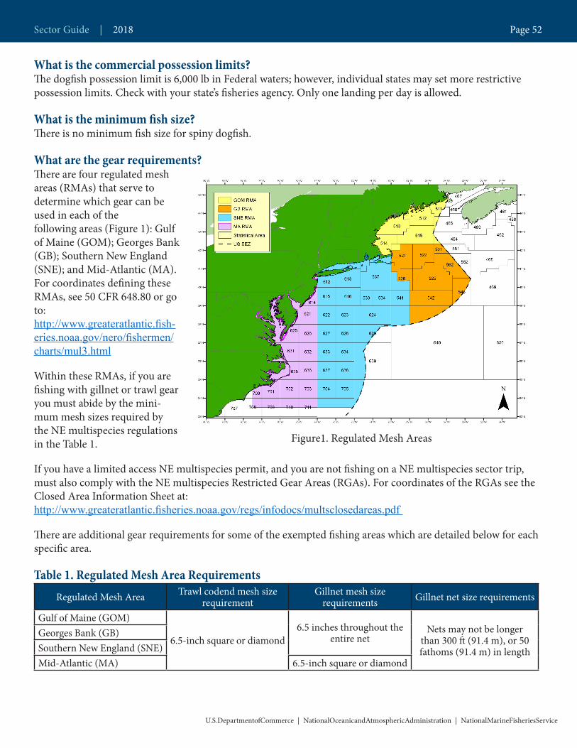
What is the commercial possession limits?The dogfish possession limit is 6,000 lb in Federal waters; however, individual states may set more restrictive possession limits. Check with your state’s fisheries agency. Only one landing per day is allowed.
What is the minimum fish size?There is no minimum fish size for spiny dogfish.
What are the gear requirements?There are four regulated mesh areas (RMAs) that serve to determine which gear can be used in each of the following areas (Figure 1): Gulf of Maine (GOM); Georges Bank (GB); Southern New England (SNE); and Mid-Atlantic (MA). For coordinates defining these RMAs, see 50 CFR 648.80 or go to: http://www.greateratlantic.fish-eries.noaa.gov/nero/fishermen/charts/mul3.html
Within these RMAs, if you are fishing with gillnet or trawl gear you must abide by the mini-mum mesh sizes required by the NE multispecies regulations in the Table 1.
If you have a limited access NE multispecies permit, and you are not fishing on a NE multispecies sector trip, must also comply with the NE multispecies Restricted Gear Areas (RGAs). For coordinates of the RGAs see the Closed Area Information Sheet at: http://www.greateratlantic.fisheries.noaa.gov/regs/infodocs/multsclosedareas.pdf
There are additional gear requirements for some of the exempted fishing areas which are detailed below for each specific area.
Table 1. Regulated Mesh Area RequirementsRegulated Mesh Area Trawl codend mesh size
requirementGillnet mesh size
requirements Gillnet net size requirements
Gulf of Maine (GOM)
6.5-inch square or diamond6.5 inches throughout the
entire netNets may not be longer
than 300 ft (91.4 m), or 50 fathoms (91.4 m) in length
Georges Bank (GB)Southern New England (SNE)Mid-Atlantic (MA) 6.5-inch square or diamond
Figure1. Regulated Mesh Areas
Sector Guide | 2018 Page 52
U.S.DepartmentofCommerce | NationalOceanicandAtmosphericAdministration | NationalMarineFisheriesService

What are the gillnet requirements for protected species?In addition to the gear requirements above, protected species requirements may also apply, depending on the season and area being fished. These additional requirements are to reduce incidental interactions between fishing gear and protected species, such as marine mammals and sea turtles. All vessels fishing with gillnets in Federal waters must comply with the applicable provisions of the:
1. Atlantic Large Whale Take Reduction Plan found in 50 CFR 229.32 and on the internet at http://www.greateratlantic.fisheries.noaa.gov/Protected/whaletrp/. Requirements include time-area closures (with limited exceptions) and gear modifications (e.g., weak links, anchoring requirements, sinking groundline, gear marking) from Maine through the east coast of Florida.
2. Harbor Porpoise Take Reduction Plan found at 50 CFR 229.33 (Gulf of Maine) and 229.34 (Mid-Atlantic) and on the internet at http://www.greateratlantic.fisheries.noaa.gov/protected/porptrp/. Requirements include time-area closures and seasonal gear modifications (e.g., pingers in the Gulf of Maine and gear requirements in the Mid-Atlantic) from Maine through North Carolina.
3. Bottlenose Dolphin Take Reduction Plan found in 50 CFR 229.35 and on the internet at http://www.nmfs.noaa.gov/pr/interactions/trt/bdtrp.htm. Requirements include time-area closures and gear restrictions (e.g., prohibited night sets, net tending, gear length requirements, etc.) from New Jersey through the east coast of Florida.
4. Gear Restrictions in the NC/VA Large Mesh Gillnet Fishery for the Protection of Sea Turtles found in 50 CFR 223.206 and on the internet at http://www.greateratlantic.fisheries.noaa.gov/Protected/seaturtles/. Requirements include seasonal time-area closures to large-mesh gillnet fishing (≥ 7 inches).
For more information, contact NMFS Greater Atlantic Region’s Protected Species Division at (978) 281-9328.
What are the record keeping and reporting requirements?The owner or operator of any vessel issued a Federal dogfish permit must maintain on board the vessel and submit an accurate Federal fishing vessel trip report (VTR) for all fishing trips (regardless of species retained). For vessels not issued a limited access NE multispecies permit, VTRs must be received by NMFS or postmarked within 15 days after the end of the reporting month. For NE multispecies limited access permit holders, VTRs must be submitted weekly and received by NMFS or postmarked by midnight of the Tuesday following the reporting week. Copies of VTRs must be retained on board the vessel for 1 year after the date of the last entry on the log. Instructions for completing VTRs can be found at http://www.greateratlantic.fisheries.noaa.gov/ro/fso/vtr.htm.
What are the exempted fishing areas?Within the GOM and GB RMAs there are six exempted fishing areas that are summarized in Table 2. A Letter of Authorization (LOA) is required to participate in some of these exempted fishing areas. LOAs can be obtained from our Permits Office at (978) 281-9370 or at http://www.greateratlantic.fisheries.noaa.gov/aps/permits/.
There are two exempted fishing areas in the SNE RMA and one exempted fishing area in the MA RMA that are summarized in Table 3.
Sector Guide | 2018 Page 53
U.S.DepartmentofCommerce | NationalOceanicandAtmosphericAdministration | NationalMarineFisheriesService
If you are fishing for spiny dogfish in Federal waters, you must also comply with closed areas for other fisheries, including NE multispecies. However, if you are using gear that is defined as not capable of catching NE multispecies, you are exempt from those closed areas and can fish in them. The following is a list of gear defined as not capable of catching NE multispecies: Pelagic hook and line; pelagic longline; spears; rakes; diving gear; cast nets; tong; harpoons; weirs; dipnets; stop nets; pound nets; pelagic gillnets; pots and traps; shrimp trawls (with properly configured grates); and surfclam/ocean quahog dredges.
The NE multispecies Closed Area regulations can be found at http://www.greateratlantic.fisheries.noaa.gov/regs/infodocs/multsclosedareas.pdf. These include seasonal and year-round closures, Essential Fish Habitat (EFH) closures, and transitting/gear stowage requirements. More information regarding multispecies regulations is available on the NMFS Greater Atlantic Region website at: http://www.greateratlantic.fisheries.noaa.gov/sustainable/species/multispecies/index.html.
Table 2. Exemption Areas (EAs) in the Gulf of Maine and Georges BankArea Name Gear Allowed LOA Required
Nantucket Shoals Dogfish Fishery EA Trawl, Gillnet YesCultivator Shoals Whiting Fishery EA Trawl YesSmall Mesh Areas 1 & 2 Trawl NoRaised Footrope Trawl Whiting Fishery Areas Trawl YesGOM/BG Dogfish Gillnet EA Gillnet NoCape Cod Spiny Dogfish EAs Gillnet, Longline, Handgear No
Table 3. Exemption Areas (EAs) in Southern New England and Mid-AtlanticArea Name Gear Allowed LOA Required
SNE EA (includes part of GB RMA) Trawl NoSNE Dogfish Gillnet EA Gillnet NoMid-Atlantic EA (includes part of SNE RMA) Trawl, Gillnet No
Sector Guide | 2018 Page 54
U.S.DepartmentofCommerce | NationalOceanicandAtmosphericAdministration | NationalMarineFisheriesService
MonkfishGeneral InformationThis summary provides a broad overview of restrictions and require-ments; the regulations summarized here may be found at 50 CFR 648. Please contact the Sustainable Fisheries Division at (978) 281-9315 for more information.
1. What is the minimum fish size?The monkfish minimum size is 17 inches total length, or 11 inches tail length.
2. What are the landing limits while on a monkfish DAS
Table 1. Summary of Monkfish Landing LimitsPermit
Category A or C B or D A, C, or G B, D, or H F
AreaNorthern Fisheries Management Area
(NFMA)
Southern Fisheries Management Area
(SFMA)
Offshore Fishery
Program Area
Landing Limit1
(tail weight per
DAS2)
1,250 lb (3,638 lb
whole weight)
600 lb (1,746 lb
whole weight
700 lb (2,037 lb
whole weight)
575 lb (1,673 lb
whole weight)
1,600 lb (4,656 lb
whole weight)
3. How does the automatic DAS adjustment trip limit overage provision work?A limited access monkfish vessel may land up to one additional day’s worth of monkfish landing limits than would otherwise be authorized based on the vessel’s actual monkfish DAS usage for that trip. In order to land the additional day’s worth of monkfish, you must declare the extra fish via VMS by submitting the ‘Monkfish Trip Limit Overage DAS Adjustment’ form prior to crossing the demarcation line upon returning to port, or, for non-VMS vessels, via the IVR line 1 hour prior to landing. To account for the landing limit overage, your monkfish DAS charge will be rounded up to the next 24-hr period plus 1 minute.
Example: If you have two monkfish landing limits worth of fish on board and you have declared into the DAS program for 15 hours you would be permitted to land two monkfish trip limits. Your DAS charge for the trip would be adjusted from 15 hours to 24 hours and 1 minute. Also, after using the DAS adjustment provision, you may go right back out, even if the additional time has not passed for which your previous trip was charged.
Questions Regarding Monkfish?
SFD(978) 281-9315
Sector Guide | 2018 Page 55
U.S.DepartmentofCommerce | NationalOceanicandAtmosphericAdministration | NationalMarineFisheriesService
Table 2. Incidental Landing Limits while on a NE Multispecies DAS, but not on a Monkfish DASNFMA SFMA
Permit Category C D E, F, or H E or H C, D, or F
Gear All gear Non-trawl Trawl
Landing Limit1 (tail weight per
DAS2)
900 lb(2,619 lb
whole weight)
750 lb(2,183 lb
whole weight)
Up to 25%(where all monkfish
is converted to tail weight2)of the total weight of fish
on board,not to exceed 300 lb
(873 lb whole weight/DAS
50 lb (146 lb whole weight)
300 lb (873 lb whole weight)
If you are under a NE multispecies DAS, you may have additional possession restrictions based on the fishery in which you are participating (e.g., Regular B-DAS Program, Closed Area I Hook-Gear Haddock Special Access Program, or the U.S./Canada Management Areas). Please visit http://www.greateratlantic.fisheries.noaa.gov/regs/infodocs/sectoruscanadaandsaps.pdf for more information on these areas.
Table 3. Incidental Landing Limits while on a Scallop DAS or in the Sea Scallop Access Area Program
Sea Scallop Access Area DAS Program3 Scallop DAS ProgramArea NFMA & SFMAGear All gear
Landing Limit1 (tail weight per DAS2)
300 lb(873 lb whole weight)
Table 4. Incidental Monkfish Landing Limits for Vessels not under a DAS ProgramDAS Program Area Gear Landing Limit1 (per trip unless stated otherwise)
No DAS
Gulf of Maine (GOM) or Georges Bank (GB) Regulated Mesh Areas
(RMAs)
Minimum mesh size or larger. See question 17.
Up to 5% (where all monkfish is converted to tail weight2) of the total weight of fish on board.
Southern New England RMA east of the Mid-
Atlantic Exemption Area boundary at 72° 30’ W
longitude
Up to 5% (where all monkfish is converted to tail weight2) of the total weight of fish on board, not to exceed 50 lb (146 lb whole weight) per day5,
up to 150 lb (437 lb whole weight) per trip.
SNE RMA west of the Mid-Atlantic Exemption Area boundary or Mid-
Atlantic RMA
Up to 5% (where all monkfish is converted to tail weight2) of the total weight of fish on board, not to exceed 450 lb (1,310 lb whole weight) per trip.
NFMA or SFMA
Mesh smaller than minimum. See question 17. 50 lb (146 lb whole weight) per day5, or partial
day, not to exceed 150 lb (437 lb whole weight) per trip.Rod and reel or handlines
only
No DAS and fishing under a skate bait Letter
of AuthorizationSNE RMA Minimum mesh size or
larger. See question 17.
Up to 5% (where all monkfish is converted to tail weight2) of the total weight of fish on board, not to exceed 50 lb (146 lb whole weight) per
day5, up to 150 lb (437 lb whole weight) per trip.
Sector Guide | 2018 Page 56
U.S.DepartmentofCommerce | NationalOceanicandAtmosphericAdministration | NationalMarineFisheriesService
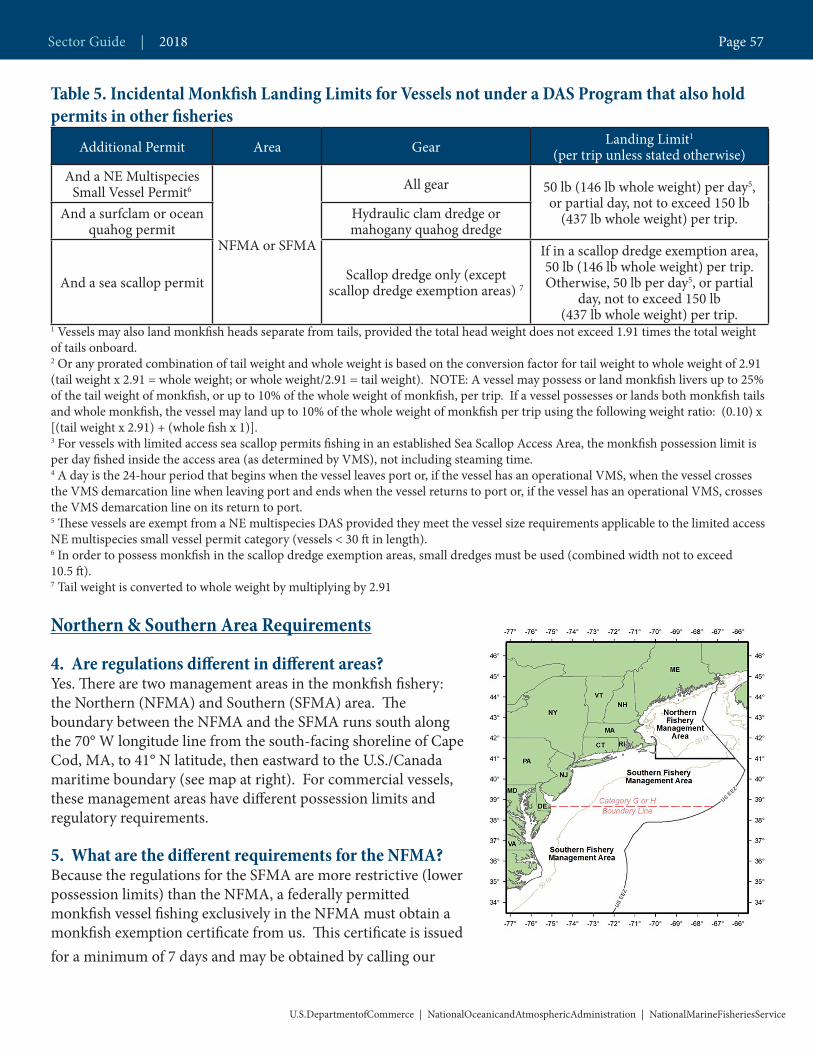
Table 5. Incidental Monkfish Landing Limits for Vessels not under a DAS Program that also hold permits in other fisheries
Additional Permit Area Gear Landing Limit1
(per trip unless stated otherwise)And a NE Multispecies
Small Vessel Permit6
NFMA or SFMA
All gear 50 lb (146 lb whole weight) per day5, or partial day, not to exceed 150 lb
(437 lb whole weight) per trip.And a surfclam or ocean quahog permit
Hydraulic clam dredge or mahogany quahog dredge
And a sea scallop permit Scallop dredge only (except scallop dredge exemption areas) 7
If in a scallop dredge exemption area, 50 lb (146 lb whole weight) per trip. Otherwise, 50 lb per day5, or partial
day, not to exceed 150 lb (437 lb whole weight) per trip.
1 Vessels may also land monkfish heads separate from tails, provided the total head weight does not exceed 1.91 times the total weight of tails onboard. 2 Or any prorated combination of tail weight and whole weight is based on the conversion factor for tail weight to whole weight of 2.91 (tail weight x 2.91 = whole weight; or whole weight/2.91 = tail weight). NOTE: A vessel may possess or land monkfish livers up to 25% of the tail weight of monkfish, or up to 10% of the whole weight of monkfish, per trip. If a vessel possesses or lands both monkfish tails and whole monkfish, the vessel may land up to 10% of the whole weight of monkfish per trip using the following weight ratio: (0.10) x [(tail weight x 2.91) + (whole fish x 1)]. 3 For vessels with limited access sea scallop permits fishing in an established Sea Scallop Access Area, the monkfish possession limit is per day fished inside the access area (as determined by VMS), not including steaming time. 4 A day is the 24-hour period that begins when the vessel leaves port or, if the vessel has an operational VMS, when the vessel crosses the VMS demarcation line when leaving port and ends when the vessel returns to port or, if the vessel has an operational VMS, crosses the VMS demarcation line on its return to port.5 These vessels are exempt from a NE multispecies DAS provided they meet the vessel size requirements applicable to the limited access NE multispecies small vessel permit category (vessels < 30 ft in length). 6 In order to possess monkfish in the scallop dredge exemption areas, small dredges must be used (combined width not to exceed 10.5 ft).7 Tail weight is converted to whole weight by multiplying by 2.91
Northern & Southern Area Requirements
4. Are regulations different in different areas? Yes. There are two management areas in the monkfish fishery: the Northern (NFMA) and Southern (SFMA) area. The boundary between the NFMA and the SFMA runs south along the 70° W longitude line from the south-facing shoreline of Cape Cod, MA, to 41° N latitude, then eastward to the U.S./Canada maritime boundary (see map at right). For commercial vessels, these management areas have different possession limits and regulatory requirements.
5. What are the different requirements for the NFMA? Because the regulations for the SFMA are more restrictive (lower possession limits) than the NFMA, a federally permitted monkfish vessel fishing exclusively in the NFMA must obtain a monkfish exemption certificate from us. This certificate is issued for a minimum of 7 days and may be obtained by calling our
U.S.DepartmentofCommerce | NationalOceanicandAtmosphericAdministration | NationalMarineFisheriesService
Sector Guide | 2018 Page 57

Permit Office at (978) 281-9370. The vessel must also make the proper trip declaration through the interactive voice response (IVR) call-in system. If a vessel has not obtained the exemption certificate and makes a trip declaration through the IVR, it is presumed to have fished in the SFMA, and will be held to the more restrictive requirements of the SFMA. This does not apply to vessels using a vessel monitoring system (VMS) unit. Such vessels must instead declare the area to be fished using VMS.
6. But what if I am fishing only in the NFMA and need to transit through the SFMA? If you have made the required declarations into the NFMA (exemption certificate and IVR, or through VMS), you may transit the SFMA, provided you do not harvest or possess monkfish or any other fish from the SFMA, and your fishing gear is properly stowed and not available for immediate use.
NE Multispecies and Monkfish Interactions
7. What if I exceed the incidental monkfish possession limit while on a NE multispecies A DAS?To have the flexibility to land monkfish caught in excess of the incidental limit when fishing on a NE multispe-cies A DAS or sector trip, a vessel must first declare the ‘monkfish option’ on the vessel’s VMS unit before leav-ing port, and can only fish in the NFMA. If this has been done, the vessel can change the trip declaration from a NE multispecies A DAS or sector trip to a Monkfish DAS declaration before crossing the demarcation line on its return to port if the incidental limit has been exceeded. When this is initiated, both NE multispecies A DAS and Monkfish DAS are charged in conjunction for the course of the trip, although the VMS declaration will show Monkfish DAS.
8. What is the charging rate for monkfish DAS? Trips using trawl gear are charged actual-time. All monkfish DAS trips using gillnet gear under 15 hours will be rounded up to 15 hours. For example, if you take a trip using gillnet gear that lasts 10 hours, you will be charged 15 hours. Trips over 15 hours will be charged actual-time.
9. What if I also have a NE multispecies DAS permit?The monkfish DAS and NE multispecies DAS interactions are very complicated and are summarized below. Please call the Sustainable Fisheries Division at (978) 281-9315 if you have any questions. • If your initial allocation of NE multispecies DAS is less than your monkfish DAS allocation, you will receive an allocation of monkfish-only DAS equal to the difference. These monkfish-only DAS are treated
separately and can be used at any time during the fishing year in an exempted fishery. If you have monk fish-only DAS, you may choose to lease in NE multispecies Category A DAS, but these leased DAS will then be tied to the monkfish-only DAS and will no longer be considered monkfish-only DAS. Please see the Large Mesh Fishery Exemptions Information Sheet for more information. A copy of this information sheet is available by calling us or online at http://www.greateratlantic.fisheries.noaa.gov/regs/infodocs/large_mesh_exemption.pdf.• If you also hold a limited access scallop permit, you must use a scallop DAS whenever you use a
monkfish DAS. • If you lease out NE multispecies Category A DAS, you must forfeit a monkfish DAS for each NE multispecies DAS leased to another vessel, equal to the difference between the number of remaining NE
multispecies DAS and the number of unused monkfish DAS.
Sector Guide | 2018 Page 58
U.S.DepartmentofCommerce | NationalOceanicandAtmosphericAdministration | NationalMarineFisheriesService
10. What if I am in a NE multispecies sector? Although sector vessels are exempt from the requirement to use a NE multispecies DAS to land allocated ground-fish stocks, they must still use a NE multispecies A DAS when using a monkfish DAS. NE multispecies DAS will be charged actual time based on the time fishing, regardless of the monkfish DAS charge. Other interactions for monkfish permit holders in a sector include:
• Catch (landings and discards) of allocated NE multispecies stocks while on a monkfish DAS and a NE mul-tispecies A DAS will count against the sector’s ACEs. This means that sectors must have ACE available for all stocks in the area a sector vessel may be fishing on a monkfish DAS.• Sector vessels fishing on a monkfish DAS and a NE multispecies A DAS (i.e., not in an exempted fishery) are required to participate in the at-sea monitoring program, because all catch of allocated groundfish stocks on that trip (including discards) counts against the sector’s ACE.• Sector vessels fishing only in the NFMA can change declarations from a NE multispecies Category A DAS or sector trip declaration that does not charge a DAS, to the corresponding monkfish DAS declaration during the course of the trip (see “Monkfish Option” below).
Monkfish OptionTo have the flexibility to land monkfish caught in excess of the incidental limit when fishing on a NE multispecies A DAS or sector trip, a vessel must first declare the ‘monkfish option’ on the vessel’s VMS unit before leaving port, and can only fish in the NFMA. If this has been done, the vessel can change the trip declaration from a NE multi-species A DAS or sector trip to a Monkfish DAS declaration before crossing the demarcation line on its return to port if the incidental limit has been exceeded. When this is initiated, both NE multispecies A DAS and Monkfish DAS are charged in conjunction for the course of the trip, although the VMS declaration will show Monkfish DAS.
11. What is the DAS allocation for 2018? 45.2 DAS for limited access vessels. Of these, only 37 can be used in the SFMA, not including any carry-over DAS.
12. Can I carry over unused monkfish DAS from last year?You may carry-over up to 4 unused monkfish DAS from the previous year. You can use carry-over DAS in either area. However, you cannot carry over DAS that are not usable because they are tied to a NE multispecies DAS.
For Example, if you have 31 unused monkfish DAS and have a NE multispecies allocation of 35 DAS and you leased out 10 of your NE multispecies DAS to another vessel, you would forfeit 6 of your monkfish DAS (10- (35 NE multispecies DAS – 31 monkfish DAS) = 6). If you then fished the remainder of your NE multispecies DAS and used all of your monkfish DAS except 6, you could not carry over your 6 remaining monkfish DAS into the next fishing year.
Reporting & Monitoring13. What are the at-sea monitoring requirements? If you are fishing on a monkfish DAS (but not in an exempted fishery), you are required to participate in the at-sea monitoring program, because all catch of allocated groundfish stocks on that trip, including discards, counts against your sector’s ACE.
Gear Information14. Can I use dredge gear on a monkfish DAS?No. You cannot have a dredge onboard while on a monkfish DAS.
Sector Guide | 2018 Page 59
U.S.DepartmentofCommerce | NationalOceanicandAtmosphericAdministration | NationalMarineFisheriesService

15. What are the trawl gear requirements while on a monkfish DAS? • The minimum mesh size is 10-inch square or 12-inch diamond mesh throughout the codend for at least 45 continuous meshes forward of the terminus of the net. The minimum mesh size for the remainder of the trawl net is the regulated mesh size specified by the regulated mesh area being fished.
Exception: If you have a Category C, D, or H permit and are fishing with trawl gear under both a monkfish and NE multispecies DAS, you are subject to the minimum mesh size determined by the NE multispecies fishery based on area fished.
• The maximum roller size in the SFMA is 6-inch diameter.
16. What are the gillnet requirements while fishing on a monkfish DAS? • The minimum mesh size is 10–inch diamond mesh, even when also fishing on a NE multispecies DAS.
Exception: If you have a Category C, D, or H permit and a NE multispecies permit, and you are fishing in the NFMA and switch from a NE multispecies VMS declaration to a monkfish VMS declaration by using the “monkfish option” on your VMS unit, you may continue to use gillnet gear with less than 10-inch diamond mesh for that specific trip. However, you must go by the more restrictive mesh sizes as outlined in the NE multispecies regulations.
• If you have a Category A or B permit you may not fish with, haul, possess, or set more than 160 gillnets at any time.• If you have a Category C,D,F, or H permit and a limited access NE multispecies permit you may not fish with, haul, possess, or set more than 150 gillnets
Note: If you are also fishing on a NE multispecies DAS you must go by the more restrictive net limits of the NE multispecies regulated mesh areas.
• Gillnets must be tagged with one tag per net, and cannot be longer than 300 ft.
17. What about other gillnet gear requirements such as markings, pinger, and marine mammal requirements? Gillnet and trap/pot fisheries also have protected resources requirements to protect marine mammals and other protected species. Please contact the Protected Resources Division at 978-281-9328 for more information.
Gillnet restrictionsCategory A or B permit
You may not fish with, haul, possess, or set more than 160 gillnets at any time.
Category C, D, F, or H permit and a limited access NE multispecies permit
You may not fish with, haul, possess, or set more than 150 gillnets at any time.
Sector Guide | 2018 Page 60
U.S.DepartmentofCommerce | NationalOceanicandAtmosphericAdministration | NationalMarineFisheriesService

18. What are the different landing limits and mesh sizes associated with the Southern New England (SNE) and Mid-Atlantic (MA) Exemption Areas? If you are using trawl gear, you need to be aware that your monkfish incidental landing limits depend upon whether you are fishing on either the east side or the west side of the NE multispecies MA exemption areas boundary. The chart to the right de-picts this area. Your monkfish inci-dental landing limit is based upon the mesh size of the smallest mesh you used during the trip. For example, if you are fishing for squid using a 1-7/8-inch diamond mesh and for summer flounder using a 5.5-inch diamond mesh on the same trip west of the 72˚ 30’ W boundary line, you are subject to the more restrictive landing limit of 50 lb tail weight per day, up to 150 lb tail weight per trip. Minimum mesh size is defined by the summer flounder regulations when fishing west of the MA Exemption Area boundary, but is defined by the NE multispecies regula-tions when fishing east of this bound-ary, in the SNE Regulated Mesh Area. See table below.
Table 6. Monkfish Landing Limits and Mesh Sizes Associated with the Southern New England and Mid-Atlantic Exemption Areas
Side of MA Exemption Area
boundary West East
Smallest mesh fished during the trip
5.5-inch diamond/6-inch square,or larger, in body, extensions,
and cod end
Smaller than 5.5-inch diamond/ 6-inch square in body,
extensions, and cod end
Smaller than 6-inch diamond/ 6.5-inch square in the body and extensions and 6.5-inch square or
diamond in the cod end
6-inch diamond/ 6.5 inch square in the
body and extensions and 6.5-inch square
or diamond in the cod end, or larger.
Landing Limit1 (per trip unless stated otherwise)
5% of total weight of fish aboard, up to 450
lb per trip50 lb per day4, up to 150 lb per trip
In SNE RMA: 5% of total weight of fish
aboard, not to exceed 50 lb per day4, up to
150 lb per trip.
Sector Guide | 2018 Page 61
U.S.DepartmentofCommerce | NationalOceanicandAtmosphericAdministration | NationalMarineFisheriesService
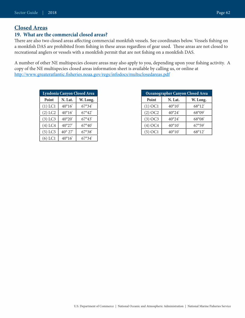
Closed Areas19. What are the commercial closed areas? There are also two closed areas affecting commercial monkfish vessels. See coordinates below. Vessels fishing on a monkfish DAS are prohibited from fishing in these areas regardless of gear used. These areas are not closed to recreational anglers or vessels with a monkfish permit that are not fishing on a monkfish DAS.
A number of other NE multispecies closure areas may also apply to you, depending upon your fishing activity. A copy of the NE multispecies closed areas information sheet is available by calling us, or online at http://www.greateratlantic.fisheries.noaa.gov/regs/infodocs/multsclosedareas.pdf
Lyndonia Canyon Closed AreaPoint N. Lat. W. Long.
(1) LC1 40°16' 67°34'(2) LC2 40°16' 67°42'(3) LC3 40°20' 67°43'(4) LC4 40°27' 67°40'(5) LC5 40° 27' 67°38'(6) LC1 40°16' 67°34'
Oceanographer Canyon Closed AreaPoint N. Lat. W. Long.
(1) OC1 40°10' 68°12'(2) OC2 40°24' 68°09'(3) OC3 40°24' 68°08'(4) OC4 40°10' 67°59'(5) OC1 40°10' 68°12'
U.S. Department of Commerce | National Oceanic and Atmospheric Administration | National Marine Fisheries Service
Sector Guide | 2018 Page 62

Questions Regarding Fish On-Line?
(978) 281-9188
Fish On-Line Login InstructionsAnyone holding a federal fishing permit is able to access vessel data via the NMFS Greater Atlantic Regional Fisheries Office’s web portal,‘Fish-On-Line’. With ‘Fish-On-Line’, it is possible to track landings information such as information reported to NMFS by seafood dealers and quickly address any missing information or inaccuracies in the data submitted. Only permit holders or their representatives will be able to access vessel landings information.
To login to the system you will need both your 6-digit federal vessel permit number and your 5-digit personal identification number (PIN). Please keep your confidential vessel PIN safe and do not share it with anyone else. If you lose your confidential vessel PIN or cannot access Fish-On-Line please contact GARFO IT Service Desk at 978-281-9188.
To login, type the following secure URL into your internet browser: https://www.greateratlantic.fisheries.noaa.gov/apps/login/login
After entering your permit number and PIN, click the ‘Login’ button.
Once you have successfully logged into the system, you will see a list of the reports available to you on the left side of the page.
Opening a ReportYou may view a report in your web browser by clicking on ‘Reports’ in the menu on the left side of the page, then selecting the report you would like to view.
Saving a ReportReports which are available to download are on the ‘Downloadable Reports’ page. To save your report, click on either the Excel or CSV format box of the report you would like to save. When the popup box appears prompting you to ‘Open’ or ‘Save’, click ‘Save’ and you will be able to choose where on your computer you wish to save the report. You will also be able to rename the report.
Sector Guide | 2018 Page 63
U.S.DepartmentofCommerce | NationalOceanicandAtmosphericAdministration | NationalMarineFisheriesService

Unavailable ReportsThere may be times when a report is unavailable. This may occur for several reasons. One such reason would be there is no data available for a specific report or permit. There may also be times when the system is updating and all reports are unavailable. In this case, your data should be available again when the system has completed updating.
Application Time OutAnother security feature you may want to be aware of is the application time out feature. After 15 minutes of inactivity you will automatically be logged out of the system and you will need to login again. This is to prevent unauthorized access of your reports should you walk away from your computer. You may log back into the system by selecting the link ‘Click to Login Again’. It is recommended that when you have completed viewing your reports that you logout of the system by selecting the ‘Log out’ link at the top of the Fish-On-Line home page. This can also help prevent unauthorized access to your data.
Account LockedYou will be allowed 3 attempts to login. If after the 3rd attempt you are not able to successfully login your account will be locked in order to prevent unauthorized access to your account.
If your account is locked, contact GARFO IT Service Desk at 978-281-9188.
Sector Guide | 2018 Page 64
U.S.DepartmentofCommerce | NationalOceanicandAtmosphericAdministration | NationalMarineFisheriesService
Questions Regarding Reporting?
SFD(978) 281-9315
Reporting Requirement NotesHow to Report Set-Only Fixed Gear TripsFor set-only fixed gear trips, your Vessel Trip Report (VTR) serial number must be entered into your vessel monitoring system (VMS) catch report. The use of your VTR serial number will link VTRs to the VMS catch report for each trip.
Vessels must submit a VTR for all trips, including trips only setting gear, trips ended because of a mechanical breakdown, and trips transiting with fish on board from one offload port to another offload port. It is important that we get VTRs from all trips, including set-only trips and trips ended early, so that we can accurately monitor catch and vessel activity.
Sector Weekly ReportingThe deadline for submission of the weekly sector catch report has been changed from 2359 hr on Thursday to 0700 hr of the second Monday following the reporting week. Fishing weeks begin on Sunday and end on Saturday. The weekly sector catch report is now due 8 days after the end of the fishing week.
Sector Guide | 2018 Page 65
U.S.DepartmentofCommerce | NationalOceanicandAtmosphericAdministration | NationalMarineFisheriesService
Sector Closed Area RegulationsTransiting RegulationsTransiting means traveling from a point outside the closed area to another open area, or to port, or from port to an area outside the closed area. A vessel may transit the areas described below provided that any prohibited gear is stowed in accordance with the regulations.
Gear Stowage RequirementsFishing gear must be stowed and not available for use when:
• Transiting a closed area;• Transiting from port to a scallop access area, or from a scallop access area to port;• Transiting an area with mesh size restrictions; or• When in possession of species that require use of a larger mesh size than the stowed gear.
Trawl GearBelow deck storage
• The net is stored below the main working deck from which the net is deployed and retrieved; and• The net is fan-folded (flaked) and bound around its circumference
On deck storage• The net is fan-folded (flaked) and bound around its circumference;• The net securely fastened to the deck or rail of the vessel; and• The towing wires, including the leg wires, are detached from the net.
On-reel stowage for transiting seasonal closure areas:• The net is secured and the entire surface of the net is covered with canvas or other similar opaque material or highly visible orange or yel-low mesh material that is securely bound; and • No containment rope, codend tripping device, or other mechanism to close off the codend is attached to the codend.
On-reel stowage for transitting the permanent closure areas• The net is secured and the entire surface of the net is covered with canvas or other similar opaque material or highly visible orange or yel-low mesh material that is securely bound; and• The codend is removed and stored below deck.
Questions Regarding Closed Areas?
SFD(978) 281-9315
Sector Guide | 2018 Page 66
U.S.DepartmentofCommerce | NationalOceanicandAtmosphericAdministration | NationalMarineFisheriesService

Hook Gear• All anchors and buoys are secured and all hook gear, including jigging machines, is covered.
Sink Gillnet Gear• All nets are covered with canvas or other similar material and lashed or otherwise securely fastened to the deck or rail, and all buoys larger than 6 inches in diameter, high flyers, and anchors are disconnected.
Sector Guide | 2018 Page 67
U.S.DepartmentofCommerce | NationalOceanicandAtmosphericAdministration | NationalMarineFisheriesService

WESTERN GULF OF MAINE GROUNDFISH CLOSURE AND HABITAT AREAS
WESTERN GULF OF MAINE GROUNDFISH CLOSUREThe Western Gulf of Maine (GOM) Groundfish Closure, depicted above, is closed year-round to all fishing vessels, with the following exemptions: Charter and party* or recreational vessels; vessels fishing with exempted gears (spears, rakes, diving gear, cast nets, tongs, harpoons, weirs, dip nets, stop nets, pound nets, pots and traps, purse seines, surf clam/ quahog dredge gear, pelagic hook and line, pelagic longlines, single pelagic gillnets, and shrimp trawls (with properly configured grates)); and vessels participating in the mid-water trawl exempted fishery.
*Charter and party vessels may fish in the Western GOM and Cashes Ledge Closure Areas provided they have a Letter of Authorization (LOA) from the Regional Administrator to enter or fish in these areas (additional requirements also apply). An LOA may be obtained by calling the Permit Office at 978-281-9370.
The Western GOM Closure Area is defined by straight lines connecting the following points in the order stated
Western GOM Closure AreaPoint N. Lat. W. Long.
WGM1 42˚ 15' 70˚ 15'WGM2 42˚ 15' 70˚ 00’WGM3 43˚ 15' 70˚ 00’WGM4 43˚ 15' 70˚ 15’WGM1 42˚ 15' 70˚ 15'
U.S. Department of Commerce | National Oceanic and Atmospheric Administration | National Marine Fisheries Service
Northeast Enforcement Division | 2018 Page 68
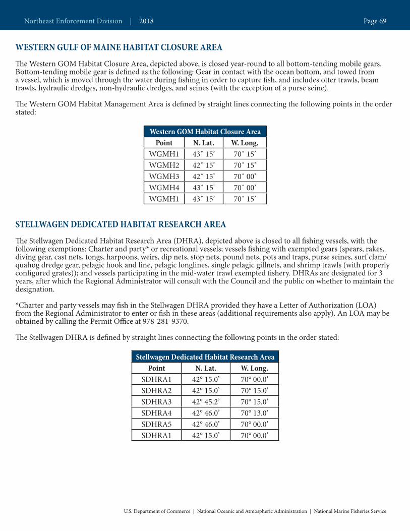
WESTERN GULF OF MAINE HABITAT CLOSURE AREA
The Western GOM Habitat Closure Area, depicted above, is closed year-round to all bottom-tending mobile gears. Bottom-tending mobile gear is defined as the following: Gear in contact with the ocean bottom, and towed from a vessel, which is moved through the water during fishing in order to capture fish, and includes otter trawls, beam trawls, hydraulic dredges, non-hydraulic dredges, and seines (with the exception of a purse seine).
The Western GOM Habitat Management Area is defined by straight lines connecting the following points in the order stated:
Western GOM Habitat Closure AreaPoint N. Lat. W. Long.
WGMH1 43˚ 15’ 70˚ 15’WGMH2 42˚ 15’ 70˚ 15’WGMH3 42˚ 15’ 70˚ 00’WGMH4 43˚ 15' 70˚ 00’WGMH1 43˚ 15’ 70˚ 15’
STELLWAGEN DEDICATED HABITAT RESEARCH AREA
The Stellwagen Dedicated Habitat Research Area (DHRA), depicted above is closed to all fishing vessels, with the following exemptions: Charter and party* or recreational vessels; vessels fishing with exempted gears (spears, rakes, diving gear, cast nets, tongs, harpoons, weirs, dip nets, stop nets, pound nets, pots and traps, purse seines, surf clam/ quahog dredge gear, pelagic hook and line, pelagic longlines, single pelagic gillnets, and shrimp trawls (with properly configured grates)); and vessels participating in the mid-water trawl exempted fishery. DHRAs are designated for 3 years, after which the Regional Administrator will consult with the Council and the public on whether to maintain the designation.
*Charter and party vessels may fish in the Stellwagen DHRA provided they have a Letter of Authorization (LOA) from the Regional Administrator to enter or fish in these areas (additional requirements also apply). An LOA may be obtained by calling the Permit Office at 978-281-9370.
The Stellwagen DHRA is defined by straight lines connecting the following points in the order stated:
Stellwagen Dedicated Habitat Research AreaPoint N. Lat. W. Long.
SDHRA1 42° 15.0’ 70° 00.0’SDHRA2 42° 15.0’ 70° 15.0'SDHRA3 42° 45.2’ 70° 15.0’SDHRA4 42° 46.0’ 70° 13.0’SDHRA5 42° 46.0’ 70° 00.0’SDHRA1 42° 15.0’ 70° 00.0’
U.S. Department of Commerce | National Oceanic and Atmospheric Administration | National Marine Fisheries Service
Northeast Enforcement Division | 2018 Page 69

CASHES LEDGE GROUNDFISH CLOSURE AND HABITAT AREAS
CASHES LEDGE CLOSURE AREA
Cashes Ledge Closure Area depicted above is closed year-round to all fishing vessels, with the following exemptions: Charter and party* or recreational vessels; vessels fishing with exempted gears (spears, rakes, diving gear, cast nets, tongs, harpoons, weirs, dip nets, stop nets, pound nets, pots and traps, purse seines, surf clam/ quahog dredge gear, pelagic hook and line, pelagic longlines, single pelagic gillnets, and shrimp trawls (with properly configured grates)); and vessels participating in the mid-water trawl exempted fishery.
*Charter and party vessels may fish in the Western GOM and Cashes Ledge Closure Areas provided they have a Letter of Authorization (LOA) from the Regional Administrator to enter or fish in these areas (additional requirements also apply). An LOA may be obtained by calling the Permit Office at 978-281-9370.
Northeast Enforcement Division | 2018 Page 70
U.S. Department of Commerce | National Oceanic and Atmospheric Administration | National Marine Fisheries Service
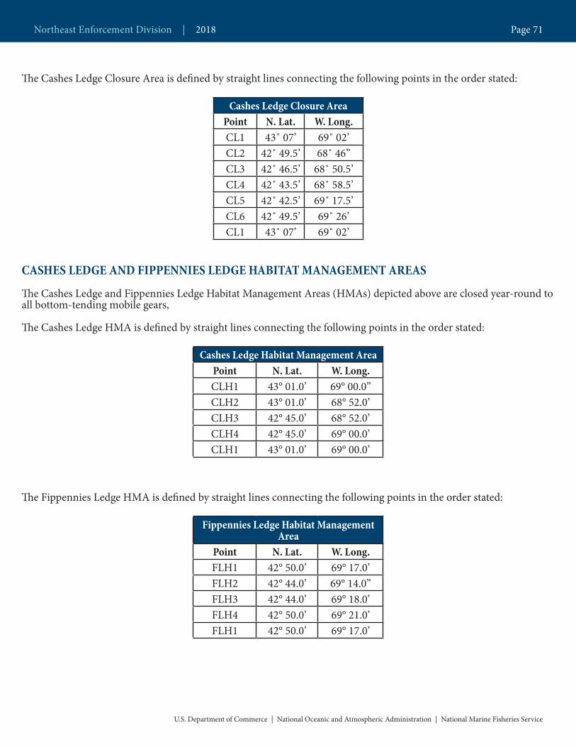
The Cashes Ledge Closure Area is defined by straight lines connecting the following points in the order stated:
Cashes Ledge Closure AreaPoint N. Lat. W. Long.CL1 43˚ 07’ 69˚ 02’CL2 42˚ 49.5’ 68˚ 46’’CL3 42˚ 46.5’ 68˚ 50.5’CL4 42˚ 43.5’ 68˚ 58.5’CL5 42˚ 42.5’ 69˚ 17.5’CL6 42˚ 49.5’ 69˚ 26’CL1 43˚ 07’ 69˚ 02’
CASHES LEDGE AND FIPPENNIES LEDGE HABITAT MANAGEMENT AREAS
The Cashes Ledge and Fippennies Ledge Habitat Management Areas (HMAs) depicted above are closed year-round to all bottom-tending mobile gears,
The Cashes Ledge HMA is defined by straight lines connecting the following points in the order stated:
Cashes Ledge Habitat Management AreaPoint N. Lat. W. Long.CLH1 43° 01.0’ 69° 00.0’’CLH2 43° 01.0’ 68° 52.0’CLH3 42° 45.0’ 68° 52.0’CLH4 42° 45.0’ 69° 00.0’CLH1 43° 01.0’ 69° 00.0’
The Fippennies Ledge HMA is defined by straight lines connecting the following points in the order stated:
Fippennies Ledge Habitat Management Area
Point N. Lat. W. Long.FLH1 42° 50.0’ 69° 17.0’FLH2 42° 44.0’ 69° 14.0’’FLH3 42° 44.0’ 69° 18.0’FLH4 42° 50.0’ 69° 21.0’FLH1 42° 50.0’ 69° 17.0’
U.S. Department of Commerce | National Oceanic and Atmospheric Administration | National Marine Fisheries Service
Northeast Enforcement Division | 2018 Page 71
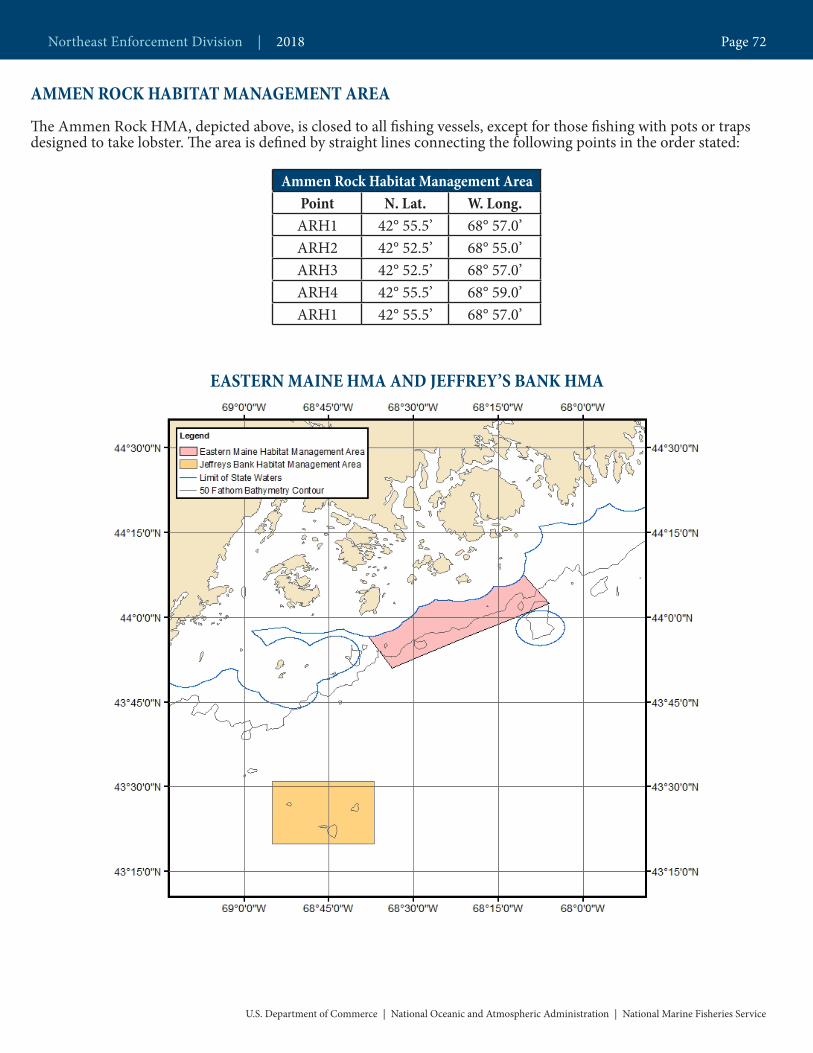
AMMEN ROCK HABITAT MANAGEMENT AREA
The Ammen Rock HMA, depicted above, is closed to all fishing vessels, except for those fishing with pots or traps designed to take lobster. The area is defined by straight lines connecting the following points in the order stated:
Ammen Rock Habitat Management AreaPoint N. Lat. W. Long.ARH1 42° 55.5’ 68° 57.0’ARH2 42° 52.5’ 68° 55.0’ARH3 42° 52.5’ 68° 57.0’ARH4 42° 55.5’ 68° 59.0’ARH1 42° 55.5’ 68° 57.0’
EASTERN MAINE HMA AND JEFFREY’S BANK HMA
U.S. Department of Commerce | National Oceanic and Atmospheric Administration | National Marine Fisheries Service
Northeast Enforcement Division | 2018 Page 72

The Eastern Maine and Jeffrey’s Bank Habitat Management Areas (HMAs) depicted above are closed year-round to all bottom-tending mobile gears,
The Eastern Maine and the Jeffrey’s Bank HMAs, respectively, are defined by straight lines connecting the following points in the order stated:
Eastern Maine Habitat Management AreaPoint N. Lat. W. Long.
EMH1* 44°07.65’ 68°10.64’EMH2 44° 02.50’ 68° 06.10’EMH3 43° 51.00’ 68° 33.90’EMH4* 43° 56.62’ 68° 38.12’
* Points 1 and 4 fall along the outer limit of Maine state waters.
GEORGES BANK DHRA, CLOSED AREA II, AND GREAT SOUTH CHANNEL HMA
Jeffrey’s Bank Habitat Management AreaPoint N. Lat. W. Long.JBH1 43° 31’ 68° 37’JBH2 43° 20’ 68° 37’JBH3 43° 20’ 68° 55’JBH4 43° 31’ 68° 55’JBH1 43° 31’ 68° 37’
U.S. Department of Commerce | National Oceanic and Atmospheric Administration | National Marine Fisheries Service
Northeast Enforcement Division | 2018 Page 73
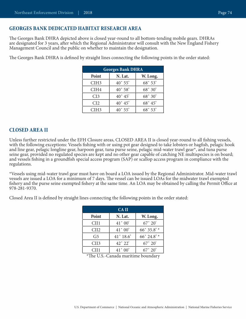
GEORGES BANK DEDICATED HABITAT RESEARCH AREA
The Georges Bank DHRA depicted above is closed year-round to all bottom-tending mobile gears. DHRAs are designated for 3 years, after which the Regional Administrator will consult with the New England Fishery Management Council and the public on whether to maintain the designation.
The Georges Bank DHRA is defined by straight lines connecting the following points in the order stated:
Georges Bank DHRAPoint N. Lat. W. Long.CIH3 40˚ 55’ 68˚ 53’CIH4 40˚ 58’ 68˚ 30’CI3 40˚ 45' 68˚ 30’CI2 40˚ 45’ 68˚ 45’
CIH3 40˚ 55’ 68˚ 53’
CLOSED AREA II
Unless further restricted under the EFH Closure areas, CLOSED AREA II is closed year-round to all fishing vessels, with the following exceptions: Vessels fishing with or using pot gear designed to take lobsters or hagfish, pelagic hook and line gear, pelagic longline gear, harpoon gear, tuna purse seine, pelagic mid-water trawl gear*, and tuna purse seine gear, provided no regulated species are kept and no other gear capable of catching NE multispecies is on board; and vessels fishing in a groundfish special access program (SAP) or scallop access program in compliance with the regulations.
*Vessels using mid-water trawl gear must have on board a LOA issued by the Regional Administrator. Mid-water trawl vessels are issued a LOA for a minimum of 7 days. The vessel can be issued LOAs for the midwater trawl exempted fishery and the purse seine exempted fishery at the same time. An LOA may be obtained by calling the Permit Office at 978-281-9370.
Closed Area II is defined by straight lines connecting the following points in the order stated:
CA IIPoint N. Lat. W. Long.CII1 41˚ 00' 67˚ 20'CII2 41˚ 00’ 66˚ 35.8’ *G5 41˚ 18.6’ 66˚ 24.8’ *
CII3 42˚ 22' 67˚ 20'CII1 41˚ 00’ 67˚ 20’
*The U.S.-Canada maritime boundary
U.S. Department of Commerce | National Oceanic and Atmospheric Administration | National Marine Fisheries Service
Northeast Enforcement Division | 2018 Page 74
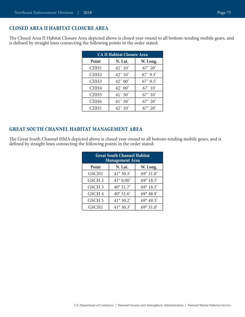
CLOSED AREA II HABITAT CLOSURE AREA
The Closed Area II Habitat Closure Area depicted above is closed year-round to all bottom-tending mobile gears, and is defined by straight lines connecting the following points in the order stated:
CA II Habitat Closure AreaPoint N. Lat. W. Long.
CIIH1 42˚ 10’ 67˚ 20’CIIH2 42˚ 10’ 67˚ 9.3’CIIH3 42˚ 00’ 67˚ 0.5'CIIH4 42˚ 00’ 67˚ 10'CIIH5 41˚ 50’ 67˚ 10’CIIH6 41˚ 50’ 67˚ 20’CIIH1 42˚ 10’ 67˚ 20’
GREAT SOUTH CHANNEL HABITAT MANAGEMENT AREA
The Great South Channel HMA depicted above is closed year-round to all bottom-tending mobile gears, and is defined by straight lines connecting the following points in the order stated:
Great South Channel Habitat Management Area
Point N. Lat. W. Long.GSCH1 41° 30.3’ 69° 31.0’GSCH 2 41° 0.00’ 69° 18.5’GSCH 3 40° 51.7’ 69° 18.5’GSCH 4 40° 51.6’ 69° 48.9’GSCH 5 41° 30.2’ 69° 49.3’GSCH1 41° 30.3’ 69° 31.0’
U.S. Department of Commerce | National Oceanic and Atmospheric Administration | National Marine Fisheries Service
Northeast Enforcement Division | 2018 Page 75

111116 112113114115
144 143
140 139 138 137 136 135
133
152
131 130 129 128
125 124 123 122 121 120
145146147
150151
132
ME
NH
MA
68°W69°W70°W71°W
44°N
43°N
42°N
111116 112113114115
144 143
140 139 138 137 136 135
133
152
131 130 129 128
125 124 123 122 121 120
145146147
150151
132
ME
NH
MA
68°W69°W70°W71°W
44°N
43°N
42°N
111116 112113114115
144 143
140 139 138 137 136 135
133
152
131 130 129 128
125 124 123 122 121 120
145146147
150151
132
ME
NH
MA
68°W69°W70°W71°W
44°N
43°N
42°N
111116 112113114115
144 143
140 139 138 137 136 135
133
152
131 130 129 128
125 124 123 122 121 120
145146147
150151
132
ME
NH
MA
68°W69°W70°W71°W
44°N
43°N
42°N
111116 112113114115
144 143
140 139 138 137 136 135
133
152
131 130 129 128
125 124 123 122 121 120
145146147
150151
132
ME
NH
MA
68°W69°W70°W71°W
44°N
43°N
42°N
111116 112113114115
144 143
140 139 138 137 136 135
133
152
131 130 129 128
125 124 123 122 121 120
145146147
150151
132
ME
NH
MA
68°W69°W70°W71°W
44°N
43°N
42°N
111116 112113114115
144 143
140 139 138 137 136 135
133
152
131 130 129 128
125 124 123 122 121 120
145146147
150151
132
ME
NH
MA
68°W69°W70°W71°W
44°N
43°N
42°N
111116 112113114115
144 143
140 139 138 137 136 135
133
152
131 130 129 128
125 124 123 122 121 120
145146147
150151
132
ME
NH
MA
68°W69°W70°W71°W
44°N
43°N
42°N
111116 112113114115
144 143
140 139 138 137 136 135
133
152
131 130 129 128
125 124 123 122 121 120
145146147
150151
132
ME
NH
MA
68°W69°W70°W71°W
44°N
43°N
42°N
111116 112113114115
144 143
140 139 138 137 136 135
133
152
131 130 129 128
125 124 123 122 121 120
145146147
150151
132
ME
NH
MA
68°W69°W70°W71°W
44°N
43°N
42°N
111116 112113114115
144 143
140 139 138 137 136 135
133
152
131 130 129 128
125 124 123 122 121 120
145146147
150151
132
ME
NH
MA
68°W69°W70°W71°W
44°N
43°N
42°N
111116 112113114115
144 143
140 139 138 137 136 135
133
152
131 130 129 128
125 124 123 122 121 120
145146147
150151
132
ME
NH
MA
68°W69°W70°W71°W
44°N
43°N
42°N
JAN FEB MAR APR
MAY JUN JUL AUG
NOVSEP DECOCT
GOM Cod Protection Closures Common Pool and Sectors Closure
Common Pool Closure (DAS, HB, & Small Vessel only)
30 Minute Square
Groundfish Closure
Spring MA BaySpawning
Protection Area(April 15 - 30)
Spring MA BaySpawning
Protection Area(April 15 - 30)
U.S.DepartmentofCommerce | NationalOceanicandAtmosphericAdministration | NationalMarineFisheriesService
Sector Guide | 2018 Page 76

GOM COD PROTECTION CLOSURESThe GOM Cod Protection Closures depicted above are closed to all fishing vessels with the following exemp-tions: Vessels that do not have a Federal NE multispecies permit and are fishing exclusively in state waters; charter and party vessels*; recreational vessels; vessels fishing on a sector trip or under a handgear A permit within GOM Cod Protection Closures IV and V; vessels fishing with exempted gears (spears, rakes, diving gear, cast nets, tongs, harpoons, weirs, dip nets, stop nets, pound nets, pots and traps, purse seines, surf clam/quahog dredge gear, pelagic hook and line, pelagic longlines, single pelagic gillnets, shrimp trawls (with properly con-figured grates)); vessels participating in the mid-water trawl exempted fishery; vessels using sea scallop dredge gear when under a scallop day-at-sea (DAS), or vessels lawfully in a scallop dredge exemption area; and vessels participating in the Raised Footrope Trawl Exempted Whiting Fishery.
*Charter and party vessels may fish in the GOM Cod Protection Closures provided they have a Letter of Au-thorization (LOA) from the Regional Administrator to enter or fish in these areas (additional requirements also apply). An LOA may be obtained by calling the Permit Office at 978-281-9370.
Sector and Common Pool Closures
GOM Cod Protection Closure I[May 1 – May 31]
Point N. latitude W. longitudeCPCI 1 43˚30’N (1)CPCI 2 43˚30’N 69˚30’WCPCI 3 43˚00’N 69˚30’WCPCI 4 43˚00’N 70˚00’WCPCI 5 42˚30’N 70˚00’WCPCI 6 42˚30’N 70˚30’WCPCI 7 42˚20’N 70˚30’WCPCI 8 42˚20’N (2) (3)CPCI 1 43˚30’N (1) (3)
1 The intersection of 43˚30’N latitude and the coastline of Maine2 The intersection of 42˚20’N latitude and the coastline of Massachusetts3 From Point 8 back to Point 1 following the coastline of the United States
U.S. Department of Commerce | National Oceanic and Atmospheric Administration | National Marine Fisheries Service
Northeast Enforcement Division | 2018 Page 77

GOM Cod Protection Closure II[June 1 – June 30]
Point N. latitude W. longitudeCPCII 1 (1) 69˚30’WCPCII 2 43˚30’N 69˚30’WCPCII 3 43˚30’N 70˚00’WCPCII 4 42˚30’N 70˚00’WCPCII 5 42˚30’N 70˚30’WCPCII 6 42˚20’N 70˚30’WCPCII 7 42˚20’N (2) (3)CPCII 8 42˚30’N (4) (3)CPCII 9 42˚30’N 70˚30’W
CPCII 10 43˚00’N 70˚30’WCPCII 11 43˚00’N (5) (6)CPCII 1 (1) 69˚30’W (6)
1 The intersection of 69˚30’W longitude and the coastline of Maine2 The intersection of 42˚20’N latitude and the coastline of Massachusetts3 From Point 7 to Point 8 following the coastline of Massachusetts4 The intersection of 42˚30’N latitude and the coastline of Massachusetts5 The intersection of 43˚00’N latitude and the coastline of New Hampshire6 From Point 11 back to Point 1 following the coastlines of New Hampshire and Maine
GOM Cod Protection Closure III[November 1 – January 31]
Point N. latitude W. longitudeCPCIII 1 42˚30’N (1)CPC III 2 42˚30’N 70˚30’WCPC III 3 42˚15’N 70˚30’WCPC III 4 42˚15’N 70˚24’WCPC III 5 42˚00’N 70˚24’WCPC III 6 42˚00’N (2) (3)CPC III 1 42˚30’N (1) (3)
1 The intersection of 42˚30’W latitude and the Massachusetts coastline2 The intersection of 42˚00’N latitude and the mainland Massachusetts coastline at Kingston, MA3 From Point 6 back to Point 1 following the coastline of Massachusetts
U.S. Department of Commerce | National Oceanic and Atmospheric Administration | National Marine Fisheries Service
Northeast Enforcement Division | 2018 Page 78
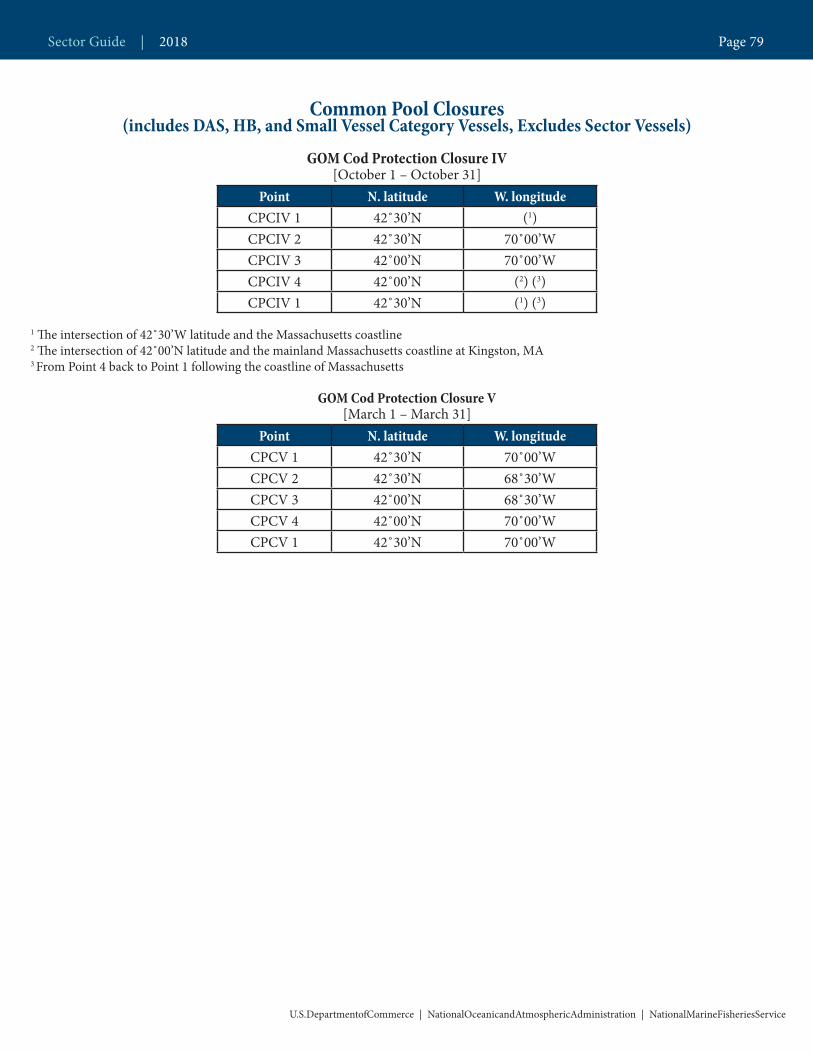
Common Pool Closures(includes DAS, HB, and Small Vessel Category Vessels, Excludes Sector Vessels)
GOM Cod Protection Closure IV[October 1 – October 31]
Point N. latitude W. longitudeCPCIV 1 42˚30’N (1)CPCIV 2 42˚30’N 70˚00’WCPCIV 3 42˚00’N 70˚00’WCPCIV 4 42˚00’N (2) (3)CPCIV 1 42˚30’N (1) (3)
1 The intersection of 42˚30’W latitude and the Massachusetts coastline2 The intersection of 42˚00’N latitude and the mainland Massachusetts coastline at Kingston, MA3 From Point 4 back to Point 1 following the coastline of Massachusetts
GOM Cod Protection Closure V[March 1 – March 31]
Point N. latitude W. longitudeCPCV 1 42˚30’N 70˚00’WCPCV 2 42˚30’N 68˚30’WCPCV 3 42˚00’N 68˚30’WCPCV 4 42˚00’N 70˚00’WCPCV 1 42˚30’N 70˚00’W
Sector Guide | 2018 Page 79
U.S.DepartmentofCommerce | NationalOceanicandAtmosphericAdministration | NationalMarineFisheriesService
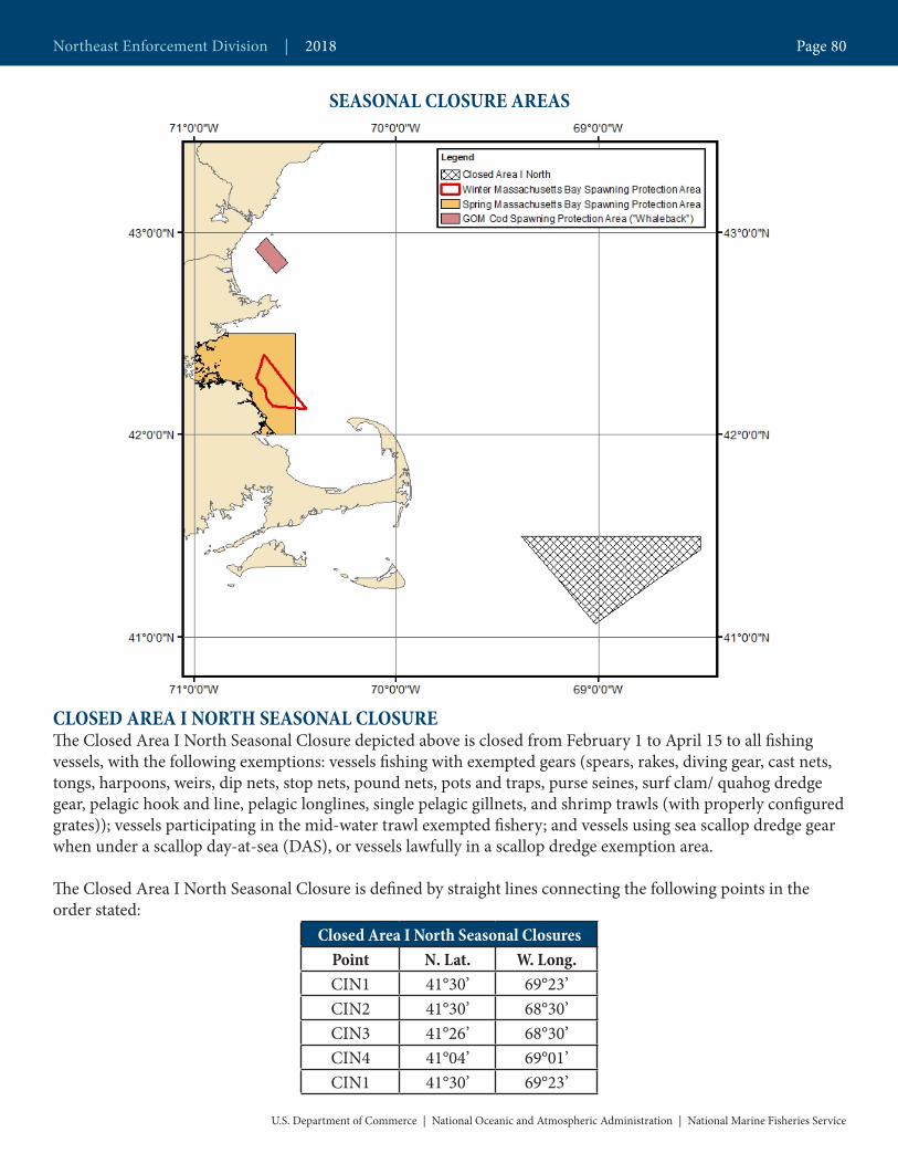
SEASONAL CLOSURE AREAS
CLOSED AREA I NORTH SEASONAL CLOSUREThe Closed Area I North Seasonal Closure depicted above is closed from February 1 to April 15 to all fishing vessels, with the following exemptions: vessels fishing with exempted gears (spears, rakes, diving gear, cast nets, tongs, harpoons, weirs, dip nets, stop nets, pound nets, pots and traps, purse seines, surf clam/ quahog dredge gear, pelagic hook and line, pelagic longlines, single pelagic gillnets, and shrimp trawls (with properly configured grates)); vessels participating in the mid-water trawl exempted fishery; and vessels using sea scallop dredge gear when under a scallop day-at-sea (DAS), or vessels lawfully in a scallop dredge exemption area.
The Closed Area I North Seasonal Closure is defined by straight lines connecting the following points in the order stated:
Closed Area I North Seasonal ClosuresPoint N. Lat. W. Long.CIN1 41°30’ 69°23’CIN2 41°30’ 68°30’CIN3 41°26’ 68°30’CIN4 41°04’ 69°01’CIN1 41°30’ 69°23’
Northeast Enforcement Division | 2018 Page 80
U.S. Department of Commerce | National Oceanic and Atmospheric Administration | National Marine Fisheries Service

WINTER MASSACHUSETTS BAY SPAWNING PROTECTION AREA
The Winter Massachusetts Bay Spawning Protection Area depicted above is closed from November 1 to January 31 to all fishing vessels, with the following exceptions: Vessels that do not have a Federal NE multispecies permit and are fishing exclusively in state waters; charter and party or recreational vessels, provided that pelagic hook and line gear is used, and there is no retention of regulated NE multispecies or ocean pout; and vessels fishing with exempted gears (spears, rakes, diving gear, cast nets, tongs, harpoons, weirs, dip nets, stop nets, pound nets, pots and traps, purse seines, surf clam/quahog dredge gear, pelagic hook and line, pelagic longlines, single pelagic gillnets, shrimp trawls (with properly configured grates)).
The Winter Massachusetts Bay Spawning Protection Area is defined by straight lines connecting the following points, which fall along the Massachusetts state waters boundary, in the order stated:
Winter Massachusetts Bay Spawning Protection Area
Point N. Lat. W. Long.WSPA1 42° 23.61’ 70° 39.21’WSPA2 42° 07.68’ 70° 26.79’
SPRING MASSACHUSETTS BAY SPAWNING PROTECTION AREA
The Spring Massachusetts Bay Spawning Protection Area depicted above is closed from April 15 to April 30 to all fishing vessels, with the exceptions listed above for the GOM Cod Protection Closures. However, recreational vessels may only fish in the Spring Massachusetts Bay Spawning Protection Area provided that they are using pelagic hook and line gear and there is no retention of regulated NE multispecies or ocean pout. Additionally, vessels participating in the purse seine exempted fishery may fish in the Spring Massachusetts Bay Spawning Protection Area.
The Spring Massachusetts Bay Spawning Protection Area is defined by straight lines connecting the following points in the order stated:
Spring Massachusetts Bay Spawning Protection Area[April 15 – April 30]
Point N. latitude W. longitude NoteSSPA1 42°30’N (1)SSPA2 42°30’N 70˚30’WSSPA3 42°00’N 70˚30’WSSPA4 42°00’N (2) (3)SSPA5 (4) 71°00’W (3)SSPA6 (5) 71°00'W (6)SSPA1 42°30’N (1) (6)
1 The intersection of 42°30’ N. lat. and the coastline at Marblehead, MA2 The intersection of 42°00’ N. lat. and the coastline at Kingston, MA3 From Point SSPA4 to Point SSPA5 following the coastline of Massachusetts4 The intersection of 71°00’ W. long and the coastline at Quincy, MA5 The intersection of 71°00’ W. long and the northernmost coastline at East Boston, Boston, MA6 From Point SSPA6 back to Point SSPA 1 following the coastline of Massachusetts
U.S. Department of Commerce | National Oceanic and Atmospheric Administration | National Marine Fisheries Service
Northeast Enforcement Division | 2018 Page 81

WHALEBACK COD SPAWNING PROTECTION AREA
Gear Restrictions: The following gear restrictions apply to either a commercial or recreational fishing vessel fishing in the GOM Cod Spawning Protection Area:• Commercial vessels: From April 1 through June 30 of each year, a commercial fishing vessel is prohibited from fishing within the GOM Cod Spawning Protection Area using gear capable of catching groundfish, including mid-water trawl and purse seine gear. Commercial fishing vessels may use only the following exempted gear in this area from April 1 through June 30:
■ Pelagic hook-and-line gear, pelagic longline gear, spears, rakes, diving gear, cast nets, tongs, harpoons, weirs, dipnets, stop nets, pound nets, pelagic gillnets, pots and traps, shrimp trawls with a properly configured grate, and surfclam and ocean quahog dredges. ■ Pelagic gillnet gear is defined as a single pelagic gillnet that is no longer than 300 ft and not greater than 6 ft deep,
with a maximum mesh size of 3 inches (7.6 cm), that is attached to the boat and fished in the upper two-thirds of the water column.
• Recreational vessels: From April 1 through June 30 of each year, a recreational vessel, including a private recreational and a charter/party vessel, may only use pelagic hook-and-line gear, as defined below, when fishing in the GOM Cod Spawning Protection Area.
■ Pelagic hook-and-line gear is defined as handline or rod and reel gear that is designed to fish for, or that is being used to fish for, pelagic species. No portion of this gear may be operated in contact with the bottom at any time.
Possession Restrictions: Any vessel fishing in the GOM Cod Spawning Protection Area and using the exempted gear described above, including pelagic hook-and-line gear by recreational vessels, is prohibited from possessing or retaining regulated species or ocean pout from April 1 through June 30 of each year.
Transiting: Both a recreational and a commercial vessel may transit the GOM Cod Spawning Protection Area, provided all gear is stowed according to existing regulations.
Point N. Latitude W. LongitudeCSPA1 42° 50.95’ 70° 32.22’CSPA2 42° 47.65’ 70° 35.64’CSPA3 42° 54.91’ 70° 41.88’CSPA4 42° 58.27’ 70° 38.64’
Sector Guide | 2018 Page 82
U.S.DepartmentofCommerce | NationalOceanicandAtmosphericAdministration | NationalMarineFisheriesService

RESTRICTED GEAR AREAS
INSHORE RESTRICTED ROLLER GEAR AREAFor all trawl vessels fishing in the GOM/GB Inshore Restricted Roller Gear Area, the maximum diameter of any part of the trawl footrope, including discs, rollers or rockhoppers, may not exceed 12 inches.
The area is defined by straight lines connecting the following points in the order stated:Inshore Restricted Roller Gear AreaPoint N. Lat. W. Long.GM1 42˚ 00’ (1)GM2 42˚ 00’ (2)GM3 42˚ 00’ (3)
GM23 42˚ 00’ 69˚ 50’GM24 43˚ 00’ 69˚ 50’GM11 43˚ 00’ 70˚ 00’GM17 43˚ 30’ 70˚ 00’GM18 43˚ 30’ (4)
(1) Massachusetts shoreline(2) Cape Cod shoreline on Cape Cod Bay(3) Cape Cod shoreline on the Atlantic Ocean(4) Maine shoreline
Northeast Enforcement Division | 2018 Page 83
U.S. Department of Commerce | National Oceanic and Atmospheric Administration | National Marine Fisheries Service

MOBILE GEAR AND LOBSTER TRAP/POT RESTRICTED GEAR AREASThe Mobile Gear and Lobster Trap/Pot Restricted Gear Areas (RGAs), depicted above, implement measures to separate mobile gear and lobster trap/pot gear in time and area according to the schedule below. Mobile gear ves-sels may transit the areas when closed, provided that all mobile gear is stowed according to gear stowage require-ments inside the area.
Mobile Gear and Lobster Trap/Pot RGAsRGA Closed to mobile gear Closed to trap/pot gear
I October 1 - June 15 June 16 – September 30II November 27 - June 15 June 16 – November 26III June 16 - November 26 January 1 – April 30IV June 16 - September 30 No closure
U.S. Department of Commerce | National Oceanic and Atmospheric Administration | National Marine Fisheries Service
Northeast Enforcement Division | 2018 Page 84

Mobile Gear and Lobster Trap/Pot RGARGA Closed to mobile gear Closed to trap/pot gear
I October 1 - June 15 June 16 – September 30Inshore Boundary
Point Latitude Longitude
To 120
69 40˚ 07.9’ 68˚ 36.0’
70 40˚ 07.2’ 68˚ 38.4’
71 40˚ 06.9’ 68˚ 46.5’
72 40˚ 08.7’ 68˚ 49.6’
73 40˚ 08.1’ 68˚ 51.0’
74 40˚ 05.7’ 68˚ 52.4’
75 40˚ 03.6’ 68˚ 57.2’
76 40˚ 03.65’ 69˚ 00.0’
77 40˚ 04.35’ 69˚ 00.5’
78 40˚ 05.2’ 69˚ 00.5’
79 40˚ 05.3’ 69˚ 01.1’
80 40˚ 08.9’ 69˚ 01.75’
81 40˚ 11.0’ 69˚ 03.8’
82 40˚ 11.6’ 69˚ 05.4’
83 40˚ 10.25’ 69˚ 04.4’
84 40˚ 09.75’ 69˚ 04.15’
85 40˚ 08.45’ 69˚ 03.6’
86 40˚ 05.65’ 69˚ 03.55’
87 40˚ 04.1’ 69˚ 03.9’
88 40˚ 02.65’ 69˚ 05.6’
89 40˚ 02.00’ 69˚ 08.35’
90 40˚ 02.65’ 69˚ 11.15’
91 40˚ 00.05’ 69˚ 14.6’
92 39˚ 57.8’ 69˚ 20.35’
93 39˚ 56.65’ 69˚ 24.4’
94 39˚ 56.1’ 69˚ 26.35’
95 39˚ 56.55’ 69˚ 34.1’
96 39˚ 57.85’ 69˚ 35.5’
97 40˚ 00.65’ 69˚ 36.5’
98 40˚ 00.9’ 69˚ 37.3’
99 39˚ 59.15’ 69˚ 37.3’
100 39˚ 58.8’ 69˚ 38.45’
102 39˚ 56.2’ 69˚ 40.2’
103 39˚ 55.75’ 69˚ 41.4’
104 39˚ 56.7’ 69˚ 53.6’
105 39˚ 57.55’ 69˚ 54.05’
106 39˚ 57.4’ 69˚ 55.9’
107 39˚ 56.9’ 69˚ 57.45’
108 39˚ 58.25’ 70˚ 03.0’
110 39˚ 59.2’ 70˚ 04.9’
111 40˚ 00.7’ 70˚ 08.7’
112 40˚ 03.75’ 70˚ 10.15’
115 40˚ 05.2’ 70˚ 10.9’
116 40˚ 02.45’ 70˚ 14.1’
119 40˚ 02.75’ 70˚ 16.1’
To 181
Offshore Boundary
Point Latitude Longitude
To 69
120 40˚ 06.4’ 68˚ 35.8’
121 40˚ 05.25’ 68˚ 39.3’
122 40˚ 05.4’ 68˚ 44.5’
123 40˚ 06.0’ 68˚ 46.5’
124 40˚ 07.4’ 68˚ 49.6’
125 40˚ 05.55’ 68˚ 49.8’
126 40˚ 03.9’ 68˚ 51.7’
127 40˚ 02.25’ 68˚ 55.4’
128 40˚ 02.6’ 69˚ 00.0’
129 40˚ 02.75’ 69˚ 00.75’
130 40˚ 04.2’ 69˚ 01.75’
131 40˚ 06.15’ 69˚ 01.95’
132 40˚ 07.25’ 69˚ 02.0’
133 40˚ 08.5’ 69˚ 02.25’
134 40˚ 09.2’ 69˚ 03.3’
135 40˚ 09.75’ 69˚ 03.3’
136 40˚ 09.55’ 69˚ 03.85’
137 40˚ 08.4’ 69˚ 03.4’
138 40˚ 07.2’ 69˚ 03.3’
139 40˚ 06.0’ 69˚ 03.1’
140 40˚ 05.4’ 69˚ 03.5’
141 40˚ 04.8’ 69˚ 03.05’
142 40˚ 03.55’ 69˚ 03.55’
143 40˚ 01.9’ 69˚ 03.95’
144 40˚ 01.0’ 69˚ 04.4’
146 39˚ 59.9’ 69˚ 06.25’
147 40˚ 00.6’ 69˚ 10.5’
148 39˚ 59.25’ 69˚ 11.15’
149 39˚ 57.45’ 69˚ 16.05’
150 39˚ 56.1’ 69˚ 20.1’
151 39˚ 54.6’ 69˚ 25.65’
152 39˚ 54.65’ 69˚ 26.9’
153 39˚ 54.8’ 69˚ 30.95’
154 39˚ 54.35’ 69˚ 33.4’
155 39˚ 55.0’ 69˚ 34.9’
156 39˚ 56.55’ 69˚ 36.0’
157 39˚ 57.95’ 69˚ 36.45’
158 39˚ 58.75’ 69˚ 36.3’
159 39˚ 58.8’ 69˚ 36.95’
160 39˚ 57.95’ 69˚ 38.1’
161 39˚ 54.5’ 69˚ 38.25’
162 39˚ 53.6’ 69˚ 46.5’
163 39˚ 54.7’ 69˚ 50.0’
Continued . . .
Continued . . .
164 39˚ 55.25’ 69˚ 51.4’
165 39˚ 55.2’ 69˚ 53.1’
166 39˚ 54.85’ 69˚ 53.9’
167 39˚ 55.7’ 69˚ 54.35’
168 39˚ 56.15’ 69˚ 55.35’
169 39˚ 56.05’ 69˚ 56.25’
170 39˚ 55.3’ 69˚ 57.1’
171 39˚ 54.8’ 69˚ 58.6’
172 39˚ 56.05’ 70˚ 00.65’
173 39˚ 55.3’ 70˚ 02.95’
174 39˚ 56.9’ 70˚ 11.3’
175 39˚ 58.9’ 70˚ 11.5’
176 39˚ 59.6’ 70˚ 11.1’
177 40˚ 01.35’ 70˚ 11.2’
178 40˚ 02.6’ 70˚ 12.0’
179 40˚ 00.4’ 70˚ 12.3’
180 39˚ 59.75’ 70˚ 13.05’
181 39˚ 59.3’ 70˚ 14.0’
To 119
Sector Guide | 2018 Page 85
U.S.DepartmentofCommerce | NationalOceanicandAtmosphericAdministration | NationalMarineFisheriesService

Mobile Gear and Lobster Trap/Pot RGARGA Closed to mobile gear Closed to trap/pot gear
II November 27 - June 15 June 16 – November 26
Inshore BoundaryPoint Latitude Longitude
To 149 40˚ 02.75’ 70˚ 16.1’50 40˚ 00.7’ 70˚ 18.6’51 39˚ 59.8’ 70˚ 21.75’52 39˚ 59.75’ 70˚ 25.5’53 40˚ 03.85’ 70˚ 28.75’54 40˚ 00.55’ 70˚ 32.1’55 39˚ 59.15’ 70˚ 34.45’56 39˚ 58.9’ 70˚ 38.65’57 40˚ 00.1’ 70˚ 45.1’58 40˚ 00.5’ 70˚ 57.6’59 40˚ 02.0’ 71˚ 01.3’60 39˚ 59.3’ 71˚ 18.4’61 40˚ 00.7’ 71˚ 19.8’62 39˚ 57.5’ 71˚ 20.6’63 39˚ 53.1’ 71˚ 36.1’64 39˚ 52.6’ 71˚ 40.35’65 39˚ 53.1’ 71˚ 42.7’66 39˚ 46.95’ 71˚ 49.0’67 39˚ 41.15’ 71˚ 57.1’68 39˚ 35.45’ 72˚ 02.0’69 39˚ 32.65’ 72˚ 06.1’70 39˚ 29.75’ 72˚ 09.8’To 48
Offshore Boundary
Point Latitude Longitude
To 49
1 39˚ 59.3’ 70˚ 14.0’
2 39˚ 58.85’ 70˚ 15.2’
3 39˚ 59.3’ 70˚ 18.4’
4 39˚ 58.1’ 70˚ 19.4’
5 39˚ 57.0’ 70˚ 19.85’
6 39˚ 57.0’ 70˚ 21.25’
7 39˚ 57.5’ 70˚ 22.8’
8 39˚ 57.1’ 70˚ 25.4’
9 39˚ 57.65’ 70˚ 27.05’
10 39˚ 58.58’ 70˚ 27.7’
11 40˚ 00.65’ 70˚ 28.8’
12 40˚ 02.2’ 70˚ 29.15’
13 40˚ 01.0’ 70˚ 30.2’
14 39˚ 58.58’ 70˚ 31.85’
15 39˚ 57.05’ 70˚ 34.35’
16 39˚ 56.42’ 70˚ 36.8’
21 39˚ 58.15’ 70˚ 48.0’
24 39˚ 58.3’ 70˚ 51.1’
25 39˚ 58.1’ 70˚ 52.25’
26 39˚ 58.05’ 70˚ 53.55’
27 39˚ 58.4’ 70˚ 59.6’
28 39˚ 59.8’ 71˚ 01.05’
29 39˚ 58.2’ 71˚ 05.85’
30 39˚ 57.45’ 71˚ 12.15’
31 39˚ 57.2’ 71˚ 15.0’
32 39˚ 56.3’ 71˚ 18.95’
33 39˚ 51.4’ 71˚ 36.1’
34 39˚ 51.75’ 71˚ 41.5’
35 39˚ 50.05’ 71˚ 42.5’
36 39˚ 50.0’ 71˚ 45.0’
37 39˚ 48.95’ 71˚ 46.05’
38 39˚ 46.6’ 71˚ 46.1’
39 39˚ 43.5’ 71˚ 49.4’
40˚ 39˚ 41.3’ 71˚ 55.0’
41 39˚ 39.0’ 71˚ 55.6’
42 39˚ 36.72’ 71˚ 58.25’
43 39˚ 35.15’ 71˚ 58.55’
44 39˚ 34.5’ 72˚ 00.75’
45 39˚ 32.2’ 72˚ 02.25’
46 39˚ 32.15’ 72˚ 04.1’
47 39˚ 28.5’ 72˚ 06.5’
48 39˚ 29.0’ 72˚ 09.25’
To 70
Sector Guide | 2018 Page 86
U.S.DepartmentofCommerce | NationalOceanicandAtmosphericAdministration | NationalMarineFisheriesService

Mobile Gear and Lobster Trap/Pot RGARGA Closed to mobile gear Closed to trap/pot gearIII June 16 - November 26 January 1 – April 30
Inshore BoundaryPoint Latitude Longitude
To 49 182 40˚ 05.6’ 70˚ 17.7’183 40˚ 06.5’ 70˚ 40 .05’184 40˚ 11.05’ 70˚ 45.8’185 40˚ 12.75’ 70˚ 55.05’186 40˚ 10.7’ 71˚ 10.25’187 39˚ 57.9’ 71˚ 28.7’188 39˚ 55.6’ 71˚ 41.2’189 39˚ 55.85’ 71˚ 45.0’190 39˚ 53.75’ 71˚ 52.25’191 39˚ 47.2’ 72˚ 01.6’192 39˚ 33.65’ 72˚ 15.0’To 70
Offshore BoundaryPoint Latitude Longitude
To 18249 40˚ 02.75’ 70˚ 16.1’50 40˚ 00.7’ 70˚ 18.6’51 39˚ 59.8’ 70˚ 21.75’52 39˚ 59.75’ 70˚ 25.5’53 40˚ 03.85’ 70˚ 28.75’54 40˚ 00.55’ 70˚ 32.1’55 39˚ 59.15’ 70˚ 34.45’56 39˚ 58.9’ 70˚ 38.65’57 40˚ 00.1’ 70˚ 45.1’58 40˚ 00.5’ 70˚ 57.6’59 40˚ 02.0’ 71˚ 01.3’60 39˚ 59.3’ 71˚ 18.4’61 40˚ 00.7’ 71˚ 19.8’62 39˚ 57.5’ 71˚ 20.6’63 39˚ 53.1’ 71˚ 40.35’64 39˚ 52.6’ 71˚ 40.35’65 39˚ 53.1’ 71˚ 42.7’66 39˚ 46.95’ 71˚ 49.0’67 39˚ 41.15’ 71˚ 57.1’68 39˚ 35.45’ 72˚ 02.0’69 39˚ 32.65’ 72˚ 06.1’70 39˚ 29.75’ 72˚ 09.8’To 192
Sector Guide | 2018 Page 87
U.S.DepartmentofCommerce | NationalOceanicandAtmosphericAdministration | NationalMarineFisheriesService

Mobile Gear and Lobster Trap/Pot RGARGA Closed to mobile gear Closed to trap/pot gearIV June 16 - September 30 No closure
Inshore BoundaryPoint Latitude Longitude
193 40˚ 13.6’ 68˚ 40.6’194 40˚ 11.6’ 68˚ 53.0’195 40˚ 14.0’ 69˚ 04.70’196 40˚ 14.30’ 69˚ 05.80’197 40˚ 05.5’ 69˚ 09.0’198 39˚ 57.3’ 69˚ 25.10’199 40˚ 00.40’ 69˚ 35.20’200 40˚ 01.70’ 69˚ 35.40’201 40˚ 01.70’ 69˚ 37.40’202 40˚ 00.50’ 69˚ 38.80’203 40˚ 01.30’ 69˚ 45.00’204 40˚ 02.10’ 69˚ 45.00’205 40˚ 07.60’ 70˚ 04.50’206 40˚ 07.80’ 70˚ 09.20’To 119
Offshore Boundary
Point Latitude Longitude
69 40˚ 07.90’ 68˚ 36.00’
70 40˚ 07.2’ 68˚ 38.40’
71 40˚ 06.90’ 68˚ 46.50’
72 40˚ 08.70’ 68˚ 49.60’
73 40˚ 08.10’ 68˚ 51.00’
74 40˚ 05.70’ 68˚ 52.40’
75 40˚ 03.60’ 68˚ 57.20’
76 40˚ 03.65’ 69˚ 00.00’
77 40˚ 04.35’ 69˚ 00.50’
78 40˚ 05.20’ 69˚ 00.50’
79 40˚ 05.30’ 69˚ 01.10’
80 40˚ 08.90’ 69˚ 01.75’
81 40˚ 11.00’ 69˚ 03.80’
82 40˚ 11.60’ 69˚ 05.40’
83 40˚ 10.25’ 69˚ 04.40’
84 40˚ 09.75’ 69˚ 04.15’
85 40˚ 08.45’ 69˚ 03.60’
86 40˚ 05.65’ 69˚ 03.55’
87 40˚ 04.10’ 69˚ 03.90’
88 40˚ 02.65’ 69˚ 05.60’
89 40˚ 02.00’ 69˚ 08.35’
90 40˚ 02.65’ 69˚ 11.15’
91 40˚ 00.05’ 69˚ 14.60’
92 39 57.8’ 69˚ 20.35’
93 39 56.75’ 69˚ 24.40’
94 39 56.50’ 69˚ 26.35’
95 39 56.80’ 69˚ 34.10’
96 39 57.85’ 69˚ 35.05’
97 40˚ 00.65’ 69˚ 37.30’
98 40˚ 00.90’ 69˚ 37.30’
99 39 59.15’ 69˚ 37.30’
100 39 58.80’ 69˚ 38.45’
102 39 56.20’ 69˚ 40.20’
103 39 55.75’ 69˚ 41.40’
104 39 56.70’ 69˚ 53.60’
105 39 57.55’ 69˚ 54.05’
106 39 57.40’ 69˚ 55.90’
107 39 56.90’ 69˚ 57.45’
108 39 58.25’ 70˚ 03.00’
110 39 59.20’ 70˚ 04.90’
111 40˚ 00.70’ 70˚ 08.70’
112 40˚ 03.75’ 70˚ 10.15’
115 40˚ 05.20’ 70˚ 10.90’
116 40˚ 02.45’ 70˚ 14.1’
119 40˚ 02.75’ 70˚ 16.1’
To 206
Sector Guide | 2018 Page 88
U.S.DepartmentofCommerce | NationalOceanicandAtmosphericAdministration | NationalMarineFisheriesService