seismic microzonation of the basel area - iit kanpur · seismic microzonation of the basel area t....
TRANSCRIPT

Seismic Microzonation of the Basel Area
T. Wenk Gehrenholz 2h, CH-8055 Zurich, Switzerland
D. Fäh Swiss Seismological Service, ETH Zurich, CH-8092 Zurich, Switzerland
SUMMARY:The Basel area belongs to a zone of moderate seismicity. Due to the high concentration of buildings, industrial plants, and engineering works, it belongs to the zone of highest seismic risk in Switzerland. To avoid inefficient design of new and retrofit of existing structures, the design spectra based on standard ground types have been replaced by microzonation with specific response spectra. The Basel area was divided into several microzones with similar tectonic and geological settings. The spectrum of each microzone was determined by numerical simulations using one-, two- and three-dimensional models with the probabilistic regional seismic hazard as input. In the longer period range, the response spectra were deterministically adjusted to account for the Basel earthquake of 1356, by far the strongest earthquake known in the area.
Keywords: Microzonation, seismic action, site specific response spectrum, essential facilities
1. INTRODUCTION
Within historical times, one of the most damaging events in central Europe was the 1356 Basel earthquake. Given its significance for assessing regional seismic hazard in central Europe, an interdisciplinary project incorporating techniques from history, seismology, archaeology, paleoseismology and engineering was recently completed to re-explore this event (Fäh et al. 2009). A macroseismic intensity up to IX on the EMS-98 scale was found in the city of Basel as well as intensities of VIII within a radius of 30 km. The moment magnitude of the 1356 Basel earthquake was evaluated to MW = 6.6 (Fäh et al. 2011).
According to the current Swiss Standard SIA 261 (2003), the Basel area belongs to a zone of moderate seismicity with a reference value of peak horizontal ground acceleration of 13% g considering the return period of 475 years for normal buildings. In general, the seismic requirements are the dominating design situation for new buildings. Most existing buildings have been built before the publication of the first seismic Standard in 1970 without considering any seismic action. They do not satisfy the seismic requirements for new buildings. To avoid inefficient designs of new buildings and unnecessary retrofits of existing buildings, the seismic action should be defined in a more precise manner than the conventional approach with response spectra based on standard ground types and regional seismic zones. For this purpose, the Basel area was divided into several microzones with similar seismic action and a specific response spectrum was calculated for each microzone.
2. REGIONAL SEISMIC HAZARD
The regional seismic hazard in Switzerland is based on the spectral hazard maps developed by Giardini et al. (2004) and divided into four seismic zones with constant design values of the horizontal ground accelerations agd of 60, 100, 130 and 160 cm/s2. According to SIA 261 (2003), the design value agd corresponds to the peak horizontal ground acceleration of ground type A (soft or hard rock) for 5% equivalent viscous damping and a probability of exceedence of 10% in 50 years (475 years return period).

Figure 2.1. Seismic hazard map of Switzerland: Horizontal spectral acceleration in cm/s2 at 5 Hz for hard rock, 5% damping, and 475 years return period (Giardini et al. 2009).
At the time of finalising the seismic zoning map in SIA 261 (2003), hazard maps were available for spectral accelerations only at 1 Hz, 5 Hz (see Fig. 2.1.) and 10 Hz. The accelerations were calculated based on attenuation functions for rather hard rock conditions with a shear wave velocity of approximately 1500 m/s in the upper 30 m. This hard rock is typical for the Alpine Foreland. It is significantly stiffer than ground type A according to SIA 261 (2003) or EN 1998-1 (2004) which comprises soft and hard rock with a shear wave velocity of about 800 m/s. It also presents a much lower amplification than ground type A. Hazard maps were available neither for peak ground acceleration nor for any of the ground types A to E standardised in SIA 261 (2003). The design value agd had to be determined indirectly from the available data for hard rock at 5 Hz and 10 Hz to map the seismic zones. For this purpose, agd was calibrated using the shape of the elastic response spectrum for ground type B together with best estimates of amplification factors between hard rock and ground type B determined from measurements by Fäh et. al. (2001).
Figure 2.2. Calibration of peak horizontal ground acceleration agd from spectral accelerations for hard rock at 5 Hz and 10 Hz using the elastic response spectrum for ground type B.

Figure 2.3. Seismic zoning map of Switzerland: Peak ground acceleration agd in cm/s2 for ground class A, 5% damping, and 475 years return period. (Sellami et al. 2002).
The different steps of the calibration procedure for the design values agd of the horizontal ground accelerations are the following (Wenk & Lestuzzi 2003):
1. Determine the spectral accelerations Shard rock, 5Hz and Shard rock, 10Hz from the hazard maps for hard rock.
2. Multiply Shard rock, 5Hz and Shard rock, 10Hz with amplification factors between hard rock and ground type B of 3.5 at 5 Hz and 2.5 at 10 Hz to determine the plateau value Se,max of the elastic response spectrum for ground type B and 5% damping as average of the two amplified values of Shard rock.
3. The design values agd is then determined by dividing Se,max through the amplification factor of the elastic response spectrum for ground type B of 2.5(S = 1.2) = 3.0, where S = 1.2 is the soil factor of ground type B for the type 1 spectrum according to EN 1998-1 (2004), see Fig. 2.2:
agd =3.5Shardrock, 5Hz + 2.5Shardrock, 10Hz
1.2 !2.5 !2 (2.1)
The resulting seismic zoning map of Switzerland is shown in Fig. 2.3. The Basel area in the North is located in seismic zone 3a with a design values of the peak horizontal ground accelerations agd of 130 cm/s2 (SIA 261 2003). The design value agd is then used to calculate the elastic spectra for the different ground types A to E. The seismic zone 3a and the response spectra for ground types A to E have now been replaced by microzonation with specific response spectra based directly on the spectral hazard of the hard rock.
3. MICROZONATION
As a first step, Fäh et al. (1997) performed a qualitative microzonation for the city of Basel based on the properties of the quaternary sediments, the influence of the ground water table, the bedrock lithology and the distance to the eastern master fault of the Rhine Graben. In the next step, the quantitative microzonation followed for the whole Basel area as a result of two large projects, the ETH project “Earthquake scenarios for Switzerland” (Fäh et al. 2000), (Kind 2002) and the INTERREG project “Seismic Microzonation in the upper Rhine Graben area” by Fäh & Huggenberger (2006).

3.1. Procedure
Due to the lack of a sufficient number of strong motion recordings for the area, the procedure for the quantitative microzonation follows an indirect approach. Firstly, the ground structure is determined and then the amplification effects are derived from numerical modelling. After mapping the geology and tectonics of the area, a map of the fundamental frequency of the ground is derived from single station recordings of ambient vibrations using H/V spectral ratios. In the second part of the project the structural model is constructed from a geological 3D-model (Zechner et al. 2001) by assigning seismic velocities to different geological units from measurements and values collected from literature. S-wave velocities are determined using a large number of ambient vibration array measurements and active seismic measurements (Kind et al., 2005), (Havenith et al., 2007). The model is validated against measured fundamental frequencies, which showed that the thickness of the sediments with low S-wave velocities in the deep Rhine Graben has been underestimated in many parts of initial model geometry. The 3D-model is then adjusted to fit all measurements and borehole data.
Site amplifications are calculated on the basis of a large number of 1D-profiles, 2D-sections of the full model (Kind, 2002), as well as for the 3D-model of the deep Rhine Graben structure (Oprsal et al., 2005) and a small area outside the Rhinegraben with typical gravel terraces (Orpsal & Fäh, 2007). The velocities of the different units were taken from measurements and models were adjusted to the measured fundamental frequencies of the sediments. Together with the map of fundamental frequencies, the amplitudes of the H/V spectral ratios, the geological model, the tectonic information, and surface sediments mapped from a large number of borehole data, a zonation of amplification site effects was performed. Recent earthquakes in the Basel area triggered the strong motion network in Basel and provided a set of weak motion data for comparison (Fäh & Huggenberger, 2006; Ripperger et al., 2009). Spectral ratios are calculated, which confirmed the amplifications as well as the measured fundamental frequencies. Finally uniform hazard spectra are derived for each zone by combining the hazard on hard rock with the amplification functions.
3.2. Subzones
Figure 3.1. Microzones and subzones of the Basel area (Fäh & Huggenberger 2006).
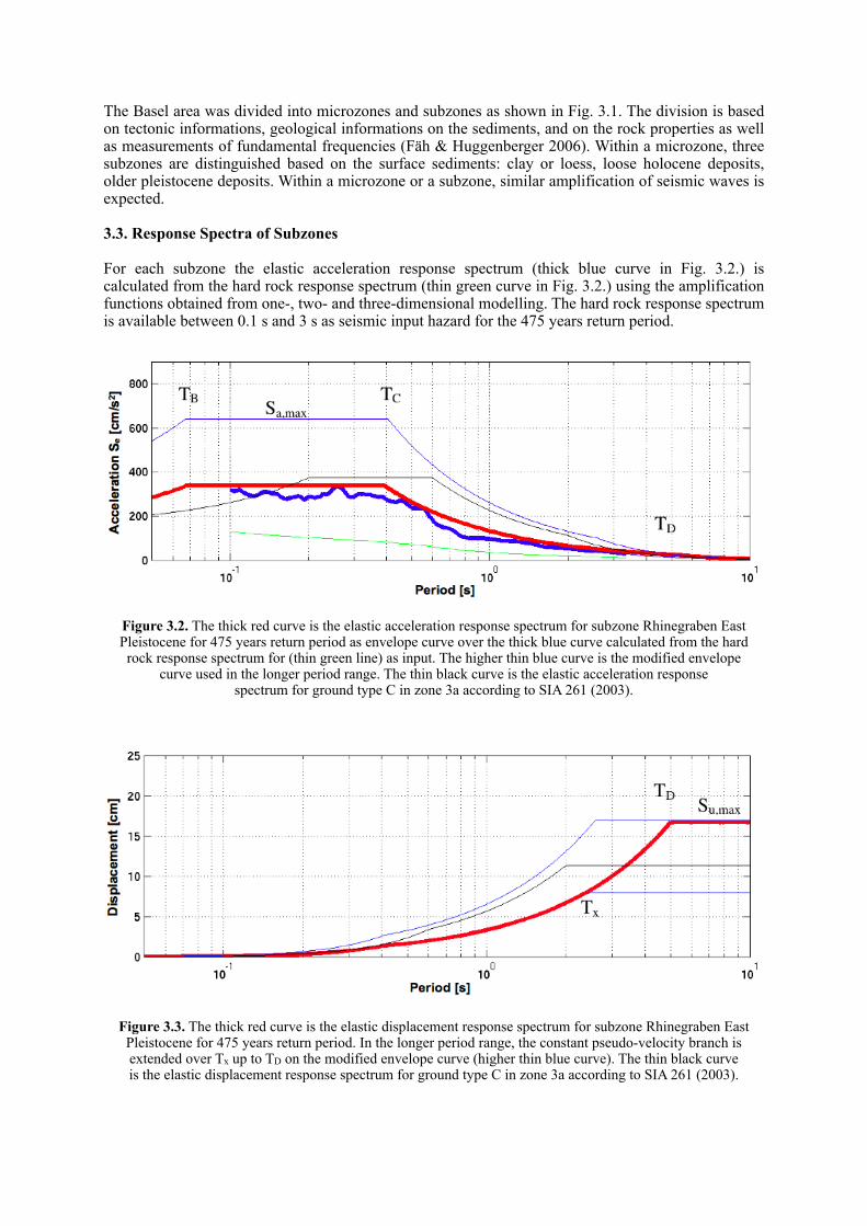
The Basel area was divided into microzones and subzones as shown in Fig. 3.1. The division is based on tectonic informations, geological informations on the sediments, and on the rock properties as well as measurements of fundamental frequencies (Fäh & Huggenberger 2006). Within a microzone, three subzones are distinguished based on the surface sediments: clay or loess, loose holocene deposits, older pleistocene deposits. Within a microzone or a subzone, similar amplification of seismic waves is expected.
3.3. Response Spectra of Subzones
For each subzone the elastic acceleration response spectrum (thick blue curve in Fig. 3.2.) is calculated from the hard rock response spectrum (thin green curve in Fig. 3.2.) using the amplification functions obtained from one-, two- and three-dimensional modelling. The hard rock response spectrum is available between 0.1 s and 3 s as seismic input hazard for the 475 years return period.
Figure 3.2. The thick red curve is the elastic acceleration response spectrum for subzone Rhinegraben East Pleistocene for 475 years return period as envelope curve over the thick blue curve calculated from the hard rock response spectrum for (thin green line) as input. The higher thin blue curve is the modified envelope
curve used in the longer period range. The thin black curve is the elastic acceleration response spectrum for ground type C in zone 3a according to SIA 261 (2003).
Figure 3.3. The thick red curve is the elastic displacement response spectrum for subzone Rhinegraben East Pleistocene for 475 years return period. In the longer period range, the constant pseudo-velocity branch is extended over Tx up to TD on the modified envelope curve (higher thin blue curve). The thin black curve is the elastic displacement response spectrum for ground type C in zone 3a according to SIA 261 (2003).
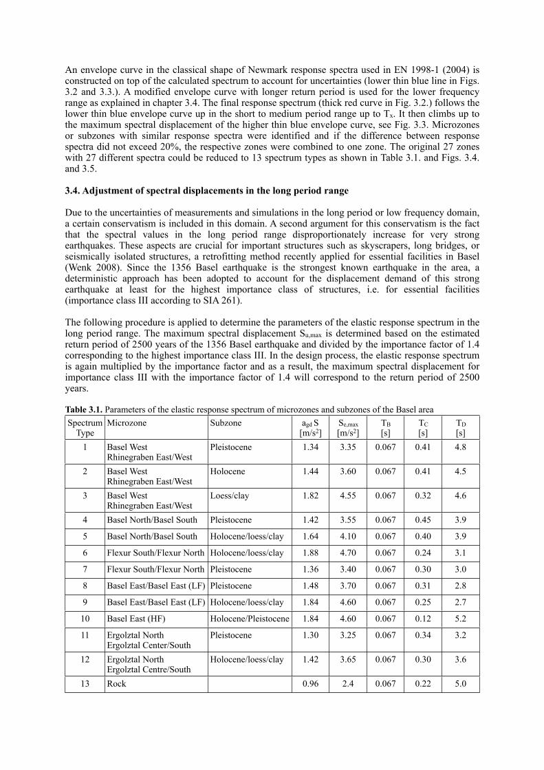
An envelope curve in the classical shape of Newmark response spectra used in EN 1998-1 (2004) is constructed on top of the calculated spectrum to account for uncertainties (lower thin blue line in Figs. 3.2 and 3.3.). A modified envelope curve with longer return period is used for the lower frequency range as explained in chapter 3.4. The final response spectrum (thick red curve in Fig. 3.2.) follows the lower thin blue envelope curve up in the short to medium period range up to Tx. It then climbs up to the maximum spectral displacement of the higher thin blue envelope curve, see Fig. 3.3. Microzones or subzones with similar response spectra were identified and if the difference between response spectra did not exceed 20%, the respective zones were combined to one zone. The original 27 zones with 27 different spectra could be reduced to 13 spectrum types as shown in Table 3.1. and Figs. 3.4. and 3.5.
3.4. Adjustment of spectral displacements in the long period range
Due to the uncertainties of measurements and simulations in the long period or low frequency domain, a certain conservatism is included in this domain. A second argument for this conservatism is the fact that the spectral values in the long period range disproportionately increase for very strong earthquakes. These aspects are crucial for important structures such as skyscrapers, long bridges, or seismically isolated structures, a retrofitting method recently applied for essential facilities in Basel (Wenk 2008). Since the 1356 Basel earthquake is the strongest known earthquake in the area, a deterministic approach has been adopted to account for the displacement demand of this strong earthquake at least for the highest importance class of structures, i.e. for essential facilities (importance class III according to SIA 261).
The following procedure is applied to determine the parameters of the elastic response spectrum in the long period range. The maximum spectral displacement Su,max is determined based on the estimated return period of 2500 years of the 1356 Basel earthquake and divided by the importance factor of 1.4 corresponding to the highest importance class III. In the design process, the elastic response spectrum is again multiplied by the importance factor and as a result, the maximum spectral displacement for importance class III with the importance factor of 1.4 will correspond to the return period of 2500 years.
Table 3.1. Parameters of the elastic response spectrum of microzones and subzones of the Basel areaSpectrum
TypeMicrozone Subzone agd S
[m/s2]Se,max[m/s2]
TB[s]
TC[s]
TD[s]
1 Basel WestRhinegraben East/West
Pleistocene 1.34 3.35 0.067 0.41 4.8
2 Basel WestRhinegraben East/West
Holocene 1.44 3.60 0.067 0.41 4.5
3 Basel WestRhinegraben East/West
Loess/clay 1.82 4.55 0.067 0.32 4.6
4 Basel North/Basel South Pleistocene 1.42 3.55 0.067 0.45 3.9
5 Basel North/Basel South Holocene/loess/clay 1.64 4.10 0.067 0.40 3.9
6 Flexur South/Flexur North Holocene/loess/clay 1.88 4.70 0.067 0.24 3.1
7 Flexur South/Flexur North Pleistocene 1.36 3.40 0.067 0.30 3.0
8 Basel East/Basel East (LF) Pleistocene 1.48 3.70 0.067 0.31 2.8
9 Basel East/Basel East (LF) Holocene/loess/clay 1.84 4.60 0.067 0.25 2.7
10 Basel East (HF) Holocene/Pleistocene 1.84 4.60 0.067 0.12 5.2
11 Ergolztal NorthErgolztal Center/South
Pleistocene 1.30 3.25 0.067 0.34 3.2
12 Ergolztal NorthErgolztal Centre/South
Holocene/loess/clay 1.42 3.65 0.067 0.30 3.6
13 Rock 0.96 2.4 0.067 0.22 5.0

Figure 3.4. Elastic acceleration response spectra for the new microzones of the Basel area and for 5% equivalent viscous damping.
Figure 3.5. Elastic displacement response spectra for the new microzones of the Basel area and for 5% equivalent viscous damping.
The higher thin blue curve in Figs. 3.2. and 3.3 is the modified envelope curve for 2500 years return period divided by the importance factor of 1.4. The constant pseudo-velocity branch of the resulting response spectrum (thick red line in Fig. 3.3) extends from TC beyond Tx up to the intersection with the modified envelope curve at TD to reach Su,max.
The microzonation of the Basel area has been implemented in a geographical information system. The spectral values can be queried on the internet for any location in the area under the following address: www.geo.bs.ch/erdbebenmikrozonierung

3.5. Comparison with neighbouring countries
As a final plausibility check, the response spectra of the microzonation of the Basel area are compared to the corresponding spectral values prescribed just across the German and French border (Figs 3.6 and 3.7.). The comparison in Tab. 3.2 comprises the range of maximum value for the reference value of the peak horizontal ground acceleration, the spectral acceleration, the spectral pseudo-velocity, and the spectral displacement.
The German border region next to Basel is located in seismic zone 3, the highest of four seismic zones according to the German Standard DIN 4149 (2005). The reference value of the peak horizontal ground acceleration of zone 3 is 0.8 m/s2, or only about 60% of the 1.3 m/s2 of the neighbouring seismic zone 3a in Switzerland. The German border region is in the special deep ground type R zone accounting for the influence of the deep geology of the Rhine Valley.
Figure 3.6. Elastic acceleration response spectra for the German border area nextto the city of Basel according to DIN 4149 (2005)
Figure 3.7. Elastic acceleration response spectra for the French border area next to the city of Basel according to AFPS90 (1990)

The elastic acceleration response spectra for subsoil classes A, B, and C in combination with the special deep ground type R are shown in Fig. 3.6. The substantial differences in the response spectra between Switzerland and Germany are mainly due to a different assessment of the regional seismic hazard (ratio 0.6). In addition, the more conservative Swiss approach in the long period range is responsible for the large differences in spectral displacements (Tab.3.2.).
The French seismic Standards for buildings (AFPS90) and for bridges (AFPS92) evaluate the seismic hazard in the border region next to Basel significantly higher than in Switzerland or Germany. The South-Eastern end of Alsace is located in seismic zone II, the highest zone of France. The reference value of the peak horizontal ground acceleration is 2.3 m/s2, almost twice as high as the 1.3 m/s2 in Basel (ratio 1.8). As a consequence, all other spectral values are also about the double of the corresponding Swiss values (Tab.3.2.). The elastic acceleration response spectra for the different French ground types (sites S0, S1, S2, S3) are shown in Fig. 3.7.
Table 3.2. Comparison of the range of spectral valuesMicrozonation
Basel Area DIN 4149 AFPS 1992
Reference value of peak horizontal ground acceleration 1.0 - 1.3 m/s2 0.8 m/s2 2.3 m/s2
Maximum spectral acceleration 2.4 - 4.7 m/s2 2.0 - 3.0 m/s2 4.6 - 5.8 m/s2
Maximum spectral pseudo-velocity 0.08 - 0.27 m/s 0.065 - 0.150 m/s 0.28 - 0.67 m/s
Maximum spectral displacement 34 - 170 mm 20 - 45 mm 115 - 460 mm
REFERENCES
EN 1998-1 (2004). Eurocode 8: Design of structures for earthquake resistance – Part 1: General rules, seismic actions and rules for buildings. European Standard EN 1998-1, European Committee for Standardisation, Brussels, Belgium.
Fäh, D., Rüttener, E., Noack, T. and P. Kruspan (1997). Microzonation of the city of Basel. Journal of Seismology, 1, 87-102.
Fäh, D., Bachmann, H., Bay, F., Becker, A., Giardini, D., Huggenberger, P., Kind, F., Lang, K., Mayer-Rosa, D., Noack, T., Sellami, S., Wenk., T. (2000). Earthquake scenarios for Switzerland. Proc. XII World Conference on Earthquake Engineering, New Zealand, Feb. 2000, Paper number 205.
Fäh, D., Kind, F., Giardini, D. (2001). A Theoretical Investigation of Average H/V Ratios. Geophys. J. Int., Vol. 145:2, 535-549.
Fäh, D., Gisler, M., Jaggi, B., Kästli, P., Lutz, T., Masciadri, V., Matt, C. Mayer-Rosa, D., Rippmann, D., Schwarz-Zanetti, G., Tauber, J., Wenk, T. (2009). The 1356 Basel earthquake: an interdisciplinary revision. Geophys. J. Int. 178:1, 351–374.
Fäh, D., Giardini, D., Kästli, P., Deichmann, N., Gisler, M., Schwarz-Zanetti, G., Alvarez-Rubio, S., Sellami, S., Edwards, B., Allmann, B., Bethmann, F., Wössner, J., Gassner-Stamm, G., Fritsche, S., Eberhard, D. (2011). ECOS-09 Earthquake Catalogue of Switzerland Release 2011. Report and Database. Public catalogue, 17.4.2011. Swiss Seismological Service ETH Zurich.
Fäh, D. and Huggenberger, P. (2006). INTERREG III, Erdbebenmikrozonierung am Southlichen Oberrhein. Zusammenfassung für das Projektgebiet Gebiet in der Schweiz. CD and Report.
Fäh, D. and Wenk, T. (2009). Mikrozonierung für die Kantone Basel Stadt und Basel Landschaft, Optimierung der Form der Antwortspektren und der Anzahl der Mikrozonen. Abschlussbericht: Teilbericht B, Swiss Seismological Service, ETH Zurich.
Giardini, D., Wiemer, S., Fäh,, D., Deichmann, N. (2004). Seismic Hazard Assessment of Switzerland, Swiss Seismological Service, ETH Zurich.
Kind, F. (2002). Development of microzonation methods: application to Basel, Switzerland, Ph.D. thesis, ETH Zurich, Available in electronic form from www.ethbib.ethz.ch.
Oprsal, I., Fäh, D., Mai, M., Giardini, D. (2005). Deterministic earthquake scenario for the Basel area - Simulating strong motion and site effects for Basel, Switzerland. J. Geophys. Res, 110, B04305, doi:10.1029/2004JB003188.
Oprsal, I., Fäh, D. (2007). 1D vs 3D strong ground motion hybrid modelling of site, and pronounced topography effects at Augusta Raurica, Switzerland - Earthquakes or battles? 4th International Conference on Earthquake Geotechnical Engineering, June 25-28, 2007 Paper No. 1416.
Ripperger, J., Kästli, P., Fäh, D., Giardini, D. (2009). Ground motion and macro-seismic intensities of a seismic event related to geothermal reservoir stimulation below the city of Basel - observations and modelling. Geophysical J. Int., 179, 1757–1771.
Sellami, S. et al. (2002). Seismic hazard map of Switzerland, Swiss Seismological Service, ETH Zurich. SIA 261 (2003). Actions on Structures. Swiss Standard SIA 261, Swiss Society of Engineers and Architects,
Zurich.Wenk, T. and Lestuzzi, P. (2003). Erdbeben. SIA-Dokumentation D 0181, Grundlagen der Projektierung von
Tragwerken, Einwirkungen auf Tragwerke, Einführung in die Normen SIA 260 und 261. Schweizerischer Ingenieur- und Architekten-Verein, Zurich, 59-66.
Wenk, T. (2008). Seismic retrofitting of structures. Strategies and collection of examples in Switzerland. Environmental studies No. 0832. Federal Office for the Environment, Bern, Switzerland. 84 pp.
Zechner, E., Kind, F., Fäh, D., Huggenberger, P. (2001). 3-D Geological model of the Southern Rhine Graben compiled on existing geological data and geophysical reference modeling, in Abstract Volume of the 2nd EUCOR-URGENT Workshop, 7.-11. October, Mont Saint-Odile, Strasbourg, France, 43 pp.