sensitive habitat and inventory mapping - volume...
TRANSCRIPT
1
32
324500
324500
324550
324550
324600
324600
324650
324650
324700
324700
324750
324750
324800
324800
324850
324850
324900
324900
324950
324950
325000
325000
325050
325050
325100
325100
325150
325150
325200
325200
325250
325250
5524
450
5524
450
5524
500
5524
500
5524
550
5524
550
5524
600
5524
600
5524
650
5524
650
5524
700
5524
700
5524
750
5524
750
5524
800
5524
800
5524
850
5524
850
5524
900
5524
900
5524
950
5524
950
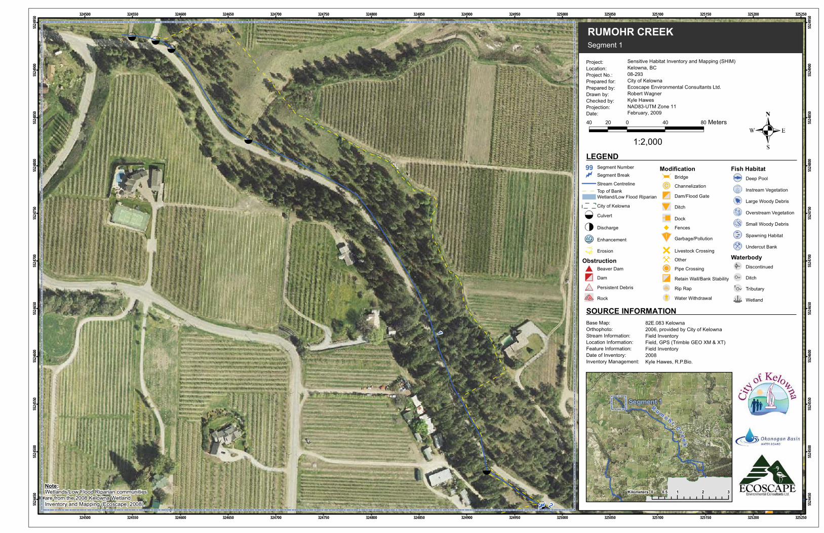
Segment 1
RUMOHR CREEK
Project:Location:Project No.:Prepared for:Prepared by:Drawn by:Checked by:Projection:Date:
LEGEND
40 0 40 8020 Meters
1:2,000
Sensitive Habitat Inventory and Mapping (SHIM)Kelowna, BC08-293City of KelownaEcoscape Environmental Consultants Ltd.Robert WagnerKyle HawesNAD83-UTM Zone 11February, 2009
82E.083 Kelowna2006, provided by City of KelownaField InventoryField, GPS (Trimble GEO XM & XT)Field Inventory2008Kyle Hawes, R.P.Bio.
Base Map:Orthophoto:Stream Information:Location Information:Feature Information:Date of Inventory:Inventory Management:
SOURCE INFORMATION
0 1 2 30.5Kilometers
Segment 1
Note:Wetlands/Low Flood Riparian communitiesare from the 2008 Kelowna WetlandInventory and Mapping (Ecoscape, 2008).
99
Stream CentrelineTop of BankWetland/Low Flood Riparian
City of Kelowna
Culvert
Discharge
Enhancement
Erosion
ObstructionBeaver Dam
Dam
Persistent Debris
Rock
ModificationBridge
Channelization
Dam/Flood Gate
Ditch
Dock
Fences
Garbage/Pollution
Livestock Crossing
Other
Pipe Crossing
Retain Wall/Bank Stability
Rip Rap
Water Withdrawal
Fish HabitatDeep Pool
Instream Vegetation
Large Woody Debris
Overstream Vegetation
Small Woody Debris
Spawning Habitat
Undercut Bank
WaterbodyDiscontinued
Ditch
Tributary
Wetland
Segment Number
Segment Break
R u m o h r
Cr eek
11
10
12
326750
326750
326800
326800
326850
326850
326900
326900
326950
326950
327000
327000
327050
327050
327100
327100
327150
327150
327200
327200
327250
327250
327300
327300
327350
327350
327400
327400
327450
327450
327500
327500
5523
000
5523
000
5523
050
5523
050
5523
100
5523
100
5523
150
5523
150
5523
200
5523
200
5523
250
5523
250
5523
300
5523
300
5523
350
5523
350
5523
400
5523
400
5523
450
5523
450
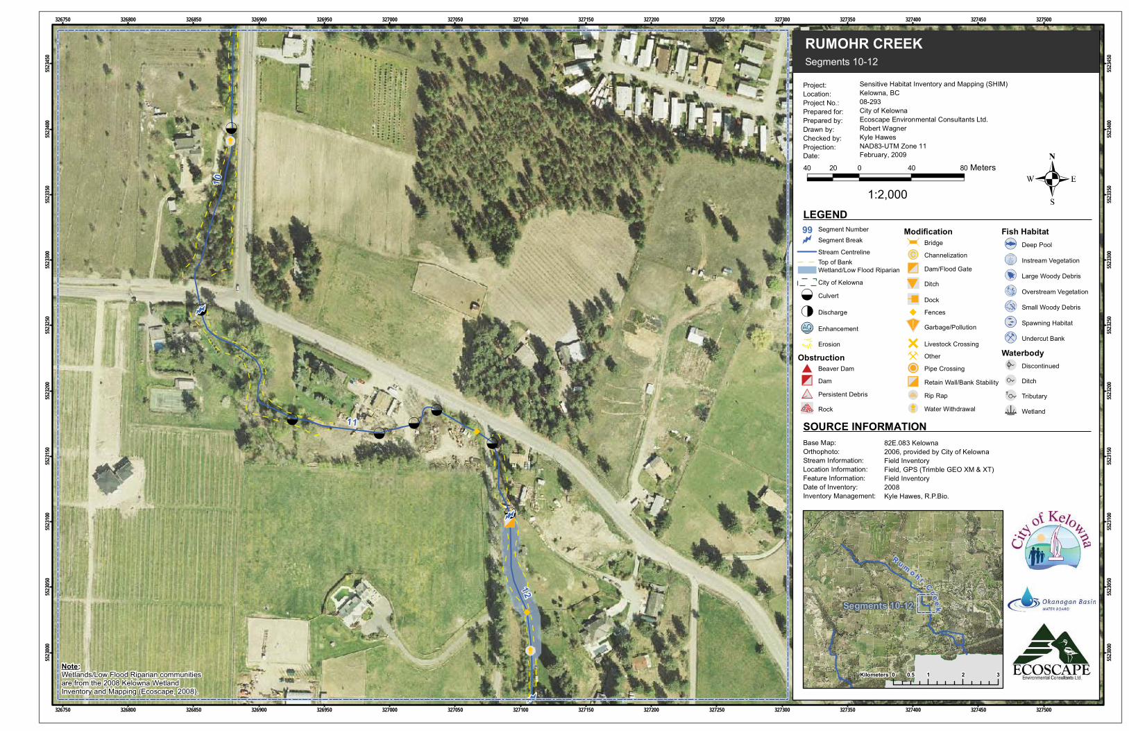
Segments 10-12
RUMOHR CREEK
Project:Location:Project No.:Prepared for:Prepared by:Drawn by:Checked by:Projection:Date:
LEGEND
40 0 40 8020 Meters
1:2,000
Sensitive Habitat Inventory and Mapping (SHIM)Kelowna, BC08-293City of KelownaEcoscape Environmental Consultants Ltd.Robert WagnerKyle HawesNAD83-UTM Zone 11February, 2009
82E.083 Kelowna2006, provided by City of KelownaField InventoryField, GPS (Trimble GEO XM & XT)Field Inventory2008Kyle Hawes, R.P.Bio.
Base Map:Orthophoto:Stream Information:Location Information:Feature Information:Date of Inventory:Inventory Management:
SOURCE INFORMATION
0 1 2 30.5Kilometers
Segments 10-12
Note:Wetlands/Low Flood Riparian communitiesare from the 2008 Kelowna WetlandInventory and Mapping (Ecoscape, 2008).
99
Stream CentrelineTop of BankWetland/Low Flood Riparian
City of Kelowna
Culvert
Discharge
Enhancement
Erosion
ObstructionBeaver Dam
Dam
Persistent Debris
Rock
ModificationBridge
Channelization
Dam/Flood Gate
Ditch
Dock
Fences
Garbage/Pollution
Livestock Crossing
Other
Pipe Crossing
Retain Wall/Bank Stability
Rip Rap
Water Withdrawal
Fish HabitatDeep Pool
Instream Vegetation
Large Woody Debris
Overstream Vegetation
Small Woody Debris
Spawning Habitat
Undercut Bank
WaterbodyDiscontinued
Ditch
Tributary
Wetland
Segment Number
Segment Break
R u mo h r
Cr eek

14
1312
326900
326900
326950
326950
327000
327000
327050
327050
327100
327100
327150
327150
327200
327200
327250
327250
327300
327300
327350
327350
327400
327400
327450
327450
327500
327500
327550
327550
327600
327600
327650
327650
5522
500
5522
500
5522
550
5522
550
5522
600
5522
600
5522
650
5522
650
5522
700
5522
700
5522
750
5522
750
5522
800
5522
800
5522
850
5522
850
5522
900
5522
900
5522
950
5522
950
5523
000
5523
000
Segments 13-14
RUMOHR CREEK
Project:Location:Project No.:Prepared for:Prepared by:Drawn by:Checked by:Projection:Date:
LEGEND
40 0 40 8020 Meters
1:2,000
Sensitive Habitat Inventory and Mapping (SHIM)Kelowna, BC08-293City of KelownaEcoscape Environmental Consultants Ltd.Robert WagnerKyle HawesNAD83-UTM Zone 11February, 2009
82E.083 Kelowna2006, provided by City of KelownaField InventoryField, GPS (Trimble GEO XM & XT)Field Inventory2008Kyle Hawes, R.P.Bio.
Base Map:Orthophoto:Stream Information:Location Information:Feature Information:Date of Inventory:Inventory Management:
SOURCE INFORMATION
0 1 2 30.5Kilometers
Segments 13-14
Note:Wetlands/Low Flood Riparian communitiesare from the 2008 Kelowna WetlandInventory and Mapping (Ecoscape, 2008).
99
Stream CentrelineTop of BankWetland/Low Flood Riparian
City of Kelowna
Culvert
Discharge
Enhancement
Erosion
ObstructionBeaver Dam
Dam
Persistent Debris
Rock
ModificationBridge
Channelization
Dam/Flood Gate
Ditch
Dock
Fences
Garbage/Pollution
Livestock Crossing
Other
Pipe Crossing
Retain Wall/Bank Stability
Rip Rap
Water Withdrawal
Fish HabitatDeep Pool
Instream Vegetation
Large Woody Debris
Overstream Vegetation
Small Woody Debris
Spawning Habitat
Undercut Bank
WaterbodyDiscontinued
Ditch
Tributary
Wetland
Segment Number
Segment Break
R u mo h r
Cr eek

14
16
15
18
17
17 .1
16 .1
19
327050
327050
327100
327100
327150
327150
327200
327200
327250
327250
327300
327300
327350
327350
327400
327400
327450
327450
327500
327500
327550
327550
327600
327600
327650
327650
327700
327700
327750
327750
327800
327800
5522
150
5522
150
5522
200
5522
200
5522
250
5522
250
5522
300
5522
300
5522
350
5522
350
5522
400
5522
400
5522
450
5522
450
5522
500
5522
500
5522
550
5522
550
5522
600
5522
600
Segments 14-16
RUMOHR CREEK
Project:Location:Project No.:Prepared for:Prepared by:Drawn by:Checked by:Projection:Date:
LEGEND
40 0 40 8020 Meters
1:2,000
Sensitive Habitat Inventory and Mapping (SHIM)Kelowna, BC08-293City of KelownaEcoscape Environmental Consultants Ltd.Robert WagnerKyle HawesNAD83-UTM Zone 11February, 2009
82E.083/82E.084 Kelowna2006, provided by City of KelownaField InventoryField, GPS (Trimble GEO XM & XT)Field Inventory2008Kyle Hawes, R.P.Bio.
Base Map:Orthophoto:Stream Information:Location Information:Feature Information:Date of Inventory:Inventory Management:
SOURCE INFORMATION
0 1 2 30.5Kilometers
Segments 14-16
Note:Wetlands/Low Flood Riparian communitiesare from the 2008 Kelowna WetlandInventory and Mapping (Ecoscape, 2008).
99
Stream CentrelineTop of BankWetland/Low Flood Riparian
City of Kelowna
Culvert
Discharge
Enhancement
Erosion
ObstructionBeaver Dam
Dam
Persistent Debris
Rock
ModificationBridge
Channelization
Dam/Flood Gate
Ditch
Dock
Fences
Garbage/Pollution
Livestock Crossing
Other
Pipe Crossing
Retain Wall/Bank Stability
Rip Rap
Water Withdrawal
Fish HabitatDeep Pool
Instream Vegetation
Large Woody Debris
Overstream Vegetation
Small Woody Debris
Spawning Habitat
Undercut Bank
WaterbodyDiscontinued
Ditch
Tributary
Wetland
Segment Number
Segment Break
R u mo h r
Cr eek

17 .1
19
18
17
18.1
20
16
21
16.1
327600
327600
327650
327650
327700
327700
327750
327750
327800
327800
327850
327850
327900
327900
327950
327950
328000
328000
328050
328050
328100
328100
328150
328150
328200
328200
328250
328250
328300
328300
328350
328350
5522
000
5522
000
5522
050
5522
050
5522
100
5522
100
5522
150
5522
150
5522
200
5522
200
5522
250
5522
250
5522
300
5522
300
5522
350
5522
350
5522
400
5522
400
5522
450
5522
450
Segments 17-20
RUMOHR CREEK
Project:Location:Project No.:Prepared for:Prepared by:Drawn by:Checked by:Projection:Date:
LEGEND
40 0 40 8020 Meters
1:2,000
Sensitive Habitat Inventory and Mapping (SHIM)Kelowna, BC08-293City of KelownaEcoscape Environmental Consultants Ltd.Robert WagnerKyle HawesNAD83-UTM Zone 11February, 2009
82E.084 Kelowna2006, provided by City of KelownaField InventoryField, GPS (Trimble GEO XM & XT)Field Inventory2008Kyle Hawes, R.P.Bio.
Base Map:Orthophoto:Stream Information:Location Information:Feature Information:Date of Inventory:Inventory Management:
SOURCE INFORMATION
0 1 2 30.5Kilometers
Segments 17-20
Note:Wetlands/Low Flood Riparian communitiesare from the 2008 Kelowna WetlandInventory and Mapping (Ecoscape, 2008).
99
Stream CentrelineTop of BankWetland/Low Flood Riparian
City of Kelowna
Culvert
Discharge
Enhancement
Erosion
ObstructionBeaver Dam
Dam
Persistent Debris
Rock
ModificationBridge
Channelization
Dam/Flood Gate
Ditch
Dock
Fences
Garbage/Pollution
Livestock Crossing
Other
Pipe Crossing
Retain Wall/Bank Stability
Rip Rap
Water Withdrawal
Fish HabitatDeep Pool
Instream Vegetation
Large Woody Debris
Overstream Vegetation
Small Woody Debris
Spawning Habitat
Undercut Bank
WaterbodyDiscontinued
Ditch
Tributary
Wetland
Segment Number
Segment Break
R u mo h r
Cr eek

21
20
19
18.1
327800
327800
327850
327850
327900
327900
327950
327950
328000
328000
328050
328050
328100
328100
328150
328150
328200
328200
328250
328250
328300
328300
328350
328350
328400
328400
328450
328450
328500
328500
328550
328550
5521
600
5521
600
5521
650
5521
650
5521
700
5521
700
5521
750
5521
750
5521
800
5521
800
5521
850
5521
850
5521
900
5521
900
5521
950
5521
950
5522
000
5522
000
5522
050
5522
050Segments 20-21
RUMOHR CREEK
Project:Location:Project No.:Prepared for:Prepared by:Drawn by:Checked by:Projection:Date:
LEGEND
40 0 40 8020 Meters
1:2,000
Sensitive Habitat Inventory and Mapping (SHIM)Kelowna, BC08-293City of KelownaEcoscape Environmental Consultants Ltd.Robert WagnerKyle HawesNAD83-UTM Zone 11February, 2009
82E.084 Kelowna2006, provided by City of KelownaField InventoryField, GPS (Trimble GEO XM & XT)Field Inventory2008Kyle Hawes, R.P.Bio.
Base Map:Orthophoto:Stream Information:Location Information:Feature Information:Date of Inventory:Inventory Management:
SOURCE INFORMATION
0 1 2 30.5Kilometers
Segments 20-21Note:Wetlands/Low Flood Riparian communitiesare from the 2008 Kelowna WetlandInventory and Mapping (Ecoscape, 2008).
99
Stream CentrelineTop of BankWetland/Low Flood Riparian
City of Kelowna
Culvert
Discharge
Enhancement
Erosion
ObstructionBeaver Dam
Dam
Persistent Debris
Rock
ModificationBridge
Channelization
Dam/Flood Gate
Ditch
Dock
Fences
Garbage/Pollution
Livestock Crossing
Other
Pipe Crossing
Retain Wall/Bank Stability
Rip Rap
Water Withdrawal
Fish HabitatDeep Pool
Instream Vegetation
Large Woody Debris
Overstream Vegetation
Small Woody Debris
Spawning Habitat
Undercut Bank
WaterbodyDiscontinued
Ditch
Tributary
Wetland
Segment Number
Segment Break
R u mo h r
Cr eek

3
2
1
324950
324950
325000
325000
325050
325050
325100
325100
325150
325150
325200
325200
325250
325250
325300
325300
325350
325350
325400
325400
325450
325450
325500
325500
325550
325550
325600
325600
325650
325650
325700
325700
5524
150
5524
150
5524
200
5524
200
5524
250
5524
250
5524
300
5524
300
5524
350
5524
350
5524
400
5524
400
5524
450
5524
450
5524
500
5524
500
5524
550
5524
550
5524
600
5524
600Segments 2-3
RUMOHR CREEK
Project:Location:Project No.:Prepared for:Prepared by:Drawn by:Checked by:Projection:Date:
LEGEND
40 0 40 8020 Meters
1:2,000
Sensitive Habitat Inventory and Mapping (SHIM)Kelowna, BC08-293City of KelownaEcoscape Environmental Consultants Ltd.Robert WagnerKyle HawesNAD83-UTM Zone 11February, 2009
82E.083 Kelowna2006, provided by City of KelownaField InventoryField, GPS (Trimble GEO XM & XT)Field Inventory2008Kyle Hawes, R.P.Bio.
Base Map:Orthophoto:Stream Information:Location Information:Feature Information:Date of Inventory:Inventory Management:
SOURCE INFORMATION
0 1 2 30.5Kilometers
Segments 2-3
Note:Wetlands/Low Flood Riparian communitiesare from the 2008 Kelowna WetlandInventory and Mapping (Ecoscape, 2008).
99
Stream CentrelineTop of BankWetland/Low Flood Riparian
City of Kelowna
Culvert
Discharge
Enhancement
Erosion
ObstructionBeaver Dam
Dam
Persistent Debris
Rock
ModificationBridge
Channelization
Dam/Flood Gate
Ditch
Dock
Fences
Garbage/Pollution
Livestock Crossing
Other
Pipe Crossing
Retain Wall/Bank Stability
Rip Rap
Water Withdrawal
Fish HabitatDeep Pool
Instream Vegetation
Large Woody Debris
Overstream Vegetation
Small Woody Debris
Spawning Habitat
Undercut Bank
WaterbodyDiscontinued
Ditch
Tributary
Wetland
Segment Number
Segment Break
R u mo h r
Cr eek
3
4
325500
325500
325550
325550
325600
325600
325650
325650
325700
325700
325750
325750
325800
325800
325850
325850
325900
325900
325950
325950
326000
326000
326050
326050
326100
326100
326150
326150
326200
326200
326250
326250
5524
150
5524
150
5524
200
5524
200
5524
250
5524
250
5524
300
5524
300
5524
350
5524
350
5524
400
5524
400
5524
450
5524
450
5524
500
5524
500
5524
550
5524
550
5524
600
5524
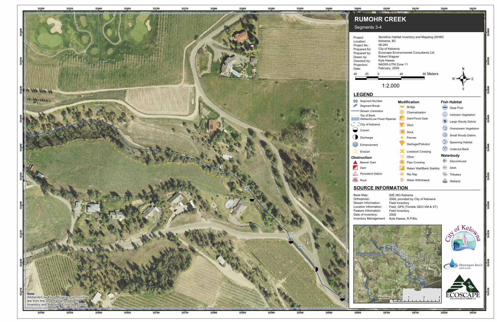
600Segments 3-4
RUMOHR CREEK
Project:Location:Project No.:Prepared for:Prepared by:Drawn by:Checked by:Projection:Date:
LEGEND
40 0 40 8020 Meters
1:2,000
Sensitive Habitat Inventory and Mapping (SHIM)Kelowna, BC08-293City of KelownaEcoscape Environmental Consultants Ltd.Robert WagnerKyle HawesNAD83-UTM Zone 11February, 2009
82E.083 Kelowna2006, provided by City of KelownaField InventoryField, GPS (Trimble GEO XM & XT)Field Inventory2008Kyle Hawes, R.P.Bio.
Base Map:Orthophoto:Stream Information:Location Information:Feature Information:Date of Inventory:Inventory Management:
SOURCE INFORMATION
0 1 2 30.5Kilometers
Segments 3-4
Note:Wetlands/Low Flood Riparian communitiesare from the 2008 Kelowna WetlandInventory and Mapping (Ecoscape, 2008).
99
Stream CentrelineTop of BankWetland/Low Flood Riparian
City of Kelowna
Culvert
Discharge
Enhancement
Erosion
ObstructionBeaver Dam
Dam
Persistent Debris
Rock
ModificationBridge
Channelization
Dam/Flood Gate
Ditch
Dock
Fences
Garbage/Pollution
Livestock Crossing
Other
Pipe Crossing
Retain Wall/Bank Stability
Rip Rap
Water Withdrawal
Fish HabitatDeep Pool
Instream Vegetation
Large Woody Debris
Overstream Vegetation
Small Woody Debris
Spawning Habitat
Undercut Bank
WaterbodyDiscontinued
Ditch
Tributary
Wetland
Segment Number
Segment Break
R u mo h r
Cr eek

5
4
6
325950
325950
326000
326000
326050
326050
326100
326100
326150
326150
326200
326200
326250
326250
326300
326300
326350
326350
326400
326400
326450
326450
326500
326500
326550
326550
326600
326600
326650
326650
326700
326700
326750
326750
5523
800
5523
800
5523
850
5523
850
5523
900
5523
900
5523
950
5523
950
5524
000
5524
000
5524
050
5524
050
5524
100
5524
100
5524
150
5524
150
5524
200
5524
200
5524
250
5524
250Segments 4-5
RUMOHR CREEK
Project:Location:Project No.:Prepared for:Prepared by:Drawn by:Checked by:Projection:Date:
LEGEND
40 0 40 8020 Meters
1:2,000
Sensitive Habitat Inventory and Mapping (SHIM)Kelowna, BC08-293City of KelownaEcoscape Environmental Consultants Ltd.Robert WagnerKyle HawesNAD83-UTM Zone 11February, 2009
82E.083 Kelowna2006, provided by City of KelownaField InventoryField, GPS (Trimble GEO XM & XT)Field Inventory2008Kyle Hawes, R.P.Bio.
Base Map:Orthophoto:Stream Information:Location Information:Feature Information:Date of Inventory:Inventory Management:
SOURCE INFORMATION
0 1 2 30.5Kilometers
Segments 4-5
Note:Wetlands/Low Flood Riparian communitiesare from the 2008 Kelowna WetlandInventory and Mapping (Ecoscape, 2008).
99
Stream CentrelineTop of BankWetland/Low Flood Riparian
City of Kelowna
Culvert
Discharge
Enhancement
Erosion
ObstructionBeaver Dam
Dam
Persistent Debris
Rock
ModificationBridge
Channelization
Dam/Flood Gate
Ditch
Dock
Fences
Garbage/Pollution
Livestock Crossing
Other
Pipe Crossing
Retain Wall/Bank Stability
Rip Rap
Water Withdrawal
Fish HabitatDeep Pool
Instream Vegetation
Large Woody Debris
Overstream Vegetation
Small Woody Debris
Spawning Habitat
Undercut Bank
WaterbodyDiscontinued
Ditch
Tributary
Wetland
Segment Number
Segment Break
R u mo h r
Cr eek

6
7
8
9
5
10
326450
326450
326500
326500
326550
326550
326600
326600
326650
326650
326700
326700
326750
326750
326800
326800
326850
326850
326900
326900
326950
326950
327000
327000
327050
327050
327100
327100
327150
327150
327200
327200
5523
450
5523
450
5523
500
5523
500
5523
550
5523
550
5523
600
5523
600
5523
650
5523
650
5523
700
5523
700
5523
750
5523
750
5523
800
5523
800
5523
850
5523
850
5523
900
5523
900
Segments 6-9
RUMOHR CREEK
Project:Location:Project No.:Prepared for:Prepared by:Drawn by:Checked by:Projection:Date:
LEGEND
40 0 40 8020 Meters
1:2,000
Sensitive Habitat Inventory and Mapping (SHIM)Kelowna, BC08-293City of KelownaEcoscape Environmental Consultants Ltd.Robert WagnerKyle HawesNAD83-UTM Zone 11February, 2009
82E.083 Kelowna2006, provided by City of KelownaField InventoryField, GPS (Trimble GEO XM & XT)Field Inventory2008Kyle Hawes, R.P.Bio.
Base Map:Orthophoto:Stream Information:Location Information:Feature Information:Date of Inventory:Inventory Management:
SOURCE INFORMATION
0 1 2 30.5Kilometers
Segments 6-9
Note:Wetlands/Low Flood Riparian communitiesare from the 2008 Kelowna WetlandInventory and Mapping (Ecoscape, 2008).
99
Stream CentrelineTop of BankWetland/Low Flood Riparian
City of Kelowna
Culvert
Discharge
Enhancement
Erosion
ObstructionBeaver Dam
Dam
Persistent Debris
Rock
ModificationBridge
Channelization
Dam/Flood Gate
Ditch
Dock
Fences
Garbage/Pollution
Livestock Crossing
Other
Pipe Crossing
Retain Wall/Bank Stability
Rip Rap
Water Withdrawal
Fish HabitatDeep Pool
Instream Vegetation
Large Woody Debris
Overstream Vegetation
Small Woody Debris
Spawning Habitat
Undercut Bank
WaterbodyDiscontinued
Ditch
Tributary
Wetland
Segment Number
Segment Break
R u mo h r
Cr eek