shalom, - polis network · shalom, since the establishment of the transport management team in 1968...
TRANSCRIPT

JERUSALEM TRANSPORTATION MASTER PLAN TEAM

Shalom,
Since the establishment of the Transport Management Team in 1968 and until today, Jerusalem has transformed. From a capital with aging infrastructure and a population of 200,000, Jerusalem became Israel’s largest city; a vibrant, modern and dynamic metropolis, 125 SqKm. wide, and home to more than 800,000 people. Therefore, developing infrastructure, tools and advanced solutions for users of public transportation and private cars is essential for the continued development of the city.
The Jerusalem Transport Management Team lives up to its name: it is a professional branch of Metropolitan Jerusalem, in charge of developing a transportation system for the entire city, based on data from transportation surveys and transportation scenario imaging. In this capacity the team plans solutions for public and private transportation in the city and implements groundbreaking technologies in the transportation infrastructure, all intended to improve the quality of life of residents and visitors to Jerusalem and to allow any person to reach their destination conveniently and quickly.
During the past decade Jerusalem has become a leader of an urban transportation revolution in Israel. Jerusalem is home to the first light rail in the country and this light rail works in concert with fast bus lines, utilizing advanced technologies for a reliable and efficient service. It has been planned based on extensive surveys of demand and advanced imaging of transportation scenarios. Real-time information systems, a static and dynamic orientation system and methods for educating the public on the implementation of changes in transportation lines are just some of the achievements of the team and have become a role model for other urban centers in Israel.
The secret to the success of the Jerusalem Transport Management Team is first and foremost a tight cooperation between the Transportation Ministry, the Jerusalem Municipality and the Finance Ministry, as well as collaboration between the team’s different branches. All relevant bodies - the team’s employees, the Transportation Ministry and the Finance Ministry, the Jerusalem Municipality, the entrepreneurs and operators, have worked together to bring the residents of Israel’s capital and its visitors the best possible service.
Dear partners,
Nadav Meroz
hh1
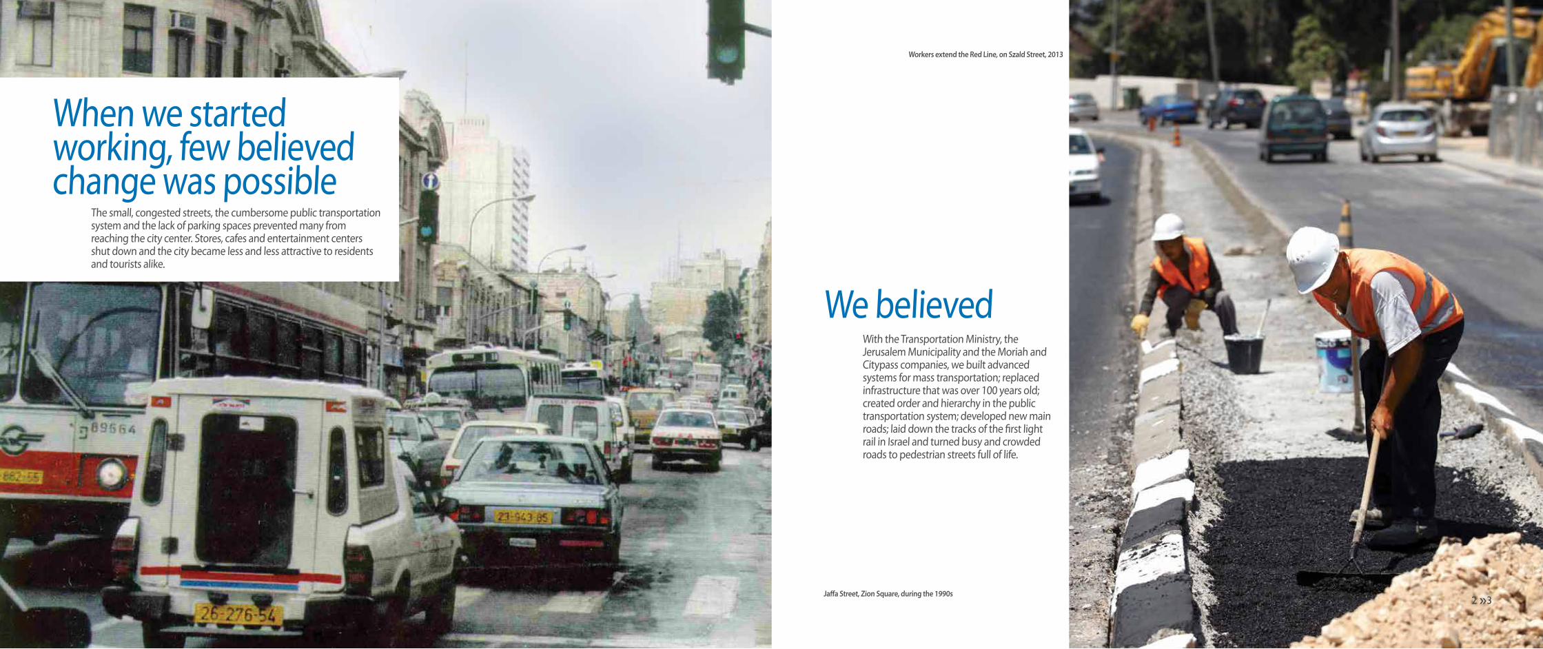
With the Transportation Ministry, the Jerusalem Municipality and the Moriah and Citypass companies, we built advanced systems for mass transportation; replaced infrastructure that was over 100 years old; created order and hierarchy in the public transportation system; developed new main roads; laid down the tracks of the first light rail in Israel and turned busy and crowded roads to pedestrian streets full of life.
We believed
When we started working, few believed change was possible
The small, congested streets, the cumbersome public transportation system and the lack of parking spaces prevented many from reaching the city center. Stores, cafes and entertainment centers shut down and the city became less and less attractive to residents and tourists alike.
Workers extend the Red Line, on Szald Street, 2013
Jaffa Street, Zion Square, during the 1990shh3 2
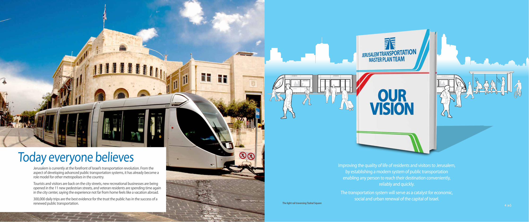
Improving the quality of life of residents and visitors to Jerusalem, by establishing a modern system of public transportation
enabling any person to reach their destination conveniently, reliably and quickly.
The transportation system will serve as a catalyst for economic, social and urban renewal of the capital of Israel.
The light rail traversing Tzahal Square
Jerusalem is currently at the forefront of Israel’s transportation revolution. From the aspect of developing advanced public transportation systems, it has already become a role model for other metropolises in the country.
Tourists and visitors are back on the city streets, new recreational businesses are being opened in the 11 new pedestrian streets, and veteran residents are spending time again in the city center, saying the experience not far from home feels like a vacation abroad.
300,000 daily trips are the best evidence for the trust the public has in the success of a renewed public transportation.
Today everyone believes
hh5 4 hh5 4
Jerusalem 830,000
Givat Ze'ev 14,300
Har Adar 3,800
Mate Yehuda 49,500
Mate Binyamin53,000
Mevasseret Zion
24,600
Beitar Illit 44,900
Ma'ale Adumim 37,100
Beit Shemesh 94,100
Gush Etziyon 20,100
Abu Gosh 6,600
Kiryat Ye'arim 3,700
Modi'in Illit 60,000
Efrat 7,900
Tzur Hadassah* 7,000
Kiryat Arba 7,200
Modi'inMaccabim-Reut
85,400
Beit El 5,900
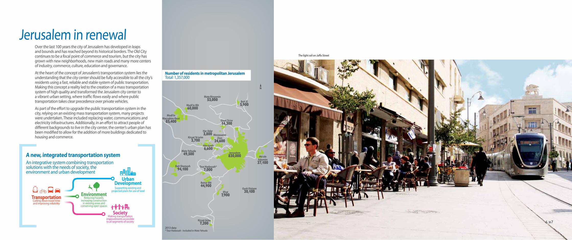
Jerusalem in renewalOver the last 100 years the city of Jerusalem has developed in leaps and bounds and has reached beyond its historical borders. The Old City continues to be a focal point of commerce and tourism, but the city has grown with new neighborhoods, new main roads and many more centers of industry, commerce, culture, education and governance.
At the heart of the concept of Jerusalem’s transportation system lies the understanding that the city center should be fully accessible to all the city’s residents using a fast, reliable and stable system of public transportation. Making this concept a reality led to the creation of a mass transportation system of high quality and transformed the Jerusalem city center to a vibrant urban setting, where traffic flows easily and where public transportation takes clear precedence over private vehicles.
As part of the effort to upgrade the public transportation system in the city, relying on an existing mass transportation system, many projects were undertaken. These included replacing water, communications and electricity infrastructures. Additionally, in an effort to attract people of different backgrounds to live in the city center, the center’s urban plan has been modified to allow for the addition of more buildings dedicated to housing and commerce.
2013 data* Tzur Hadassah - included in Mate Yehuda
The light rail on Jaffa Street
A new, integrated transportation systemAn integrative system combining transportation solutions with the needs of society, the environment and urban development
Number of residents in metropolitan JerusalemTotal: 1,357,000
TransportationCutting down travel timeand improving reliability
EnvironmentReducing hazards,
increasing construction in existing areas and
conserving open spaces
SocietyMaking transportation
improvements accessibleto all segments of society
Urban DevelopmentSupporting existing and
projected plans for use of land
hh7 6

The light rail on the bridge of stringshh9 8 hh9 8

JerusalemA challenge of demography and topography
TransportManagement
Team
Jerusalem, the largest city in Israel and the second largest metropolis in Israel, serves dozens of communities and more than a million residents. Jerusalem is also a religious, spiritual and cultural center for millions of people around the world. It is a site of pilgrimage considered holy by several religions.
The many facets of Jerusalem are evident in its streets. Hundreds of thousands of residents from different ethnicities, religions and streams live together, and each have their own language, culture, educational, financial and transportation needs.
Another striking characteristic of the city is its topography. Its location amidst mountains served in past times as a means of defending it, but today poses a challenge to urban planners.
Over the years, many attempts have been made to pave the safest and most convenient routes to reach the city and planners faced, in the past as well as today, difficult challenges. The roads inside the metropolis pose a challenge to the members of the Transport Management Team today, too. Jerusalem is home to hundreds of thousands; for many others - a place of work; and for others still - a cultural and tourist attraction.
hh11 10

The Jerusalem Transport Management Team was established by the Transportation Ministry and the Jerusalem Municipality and has been working for more than four decades. The team researches the terrain and then plans, outlines and advances transportation systems in Metropolitan Jerusalem with the use of surveys, information systems and models imaging transportation scenarios developed with some of the world’s top professionals, with an eye to make transportation as adaptable as possible to the present and future needs of the residents and visitors to the city.
Forty years of activity have given the team experience, knowledge and professionalism that have won it international awards and the appreciation of planners in Israel and the world.
The team continues to strive for implementation of its plans in Jerusalem and to adapt the city’s transportation infrastructure to its changing needs.
The residents of Metropolitan Jerusalem are always first and foremost in the eyes of the members of the Transport Management Team - their needs to conveniently get to work, to school, to government offices and to shopping centers - and finally to return home safely. All these needs are taken into account during planning.
The work plan is based on an advanced method of accumulating relevant and up-to-date information on the different needs of residents and visitors to the metropolis. This method involves using surveys and meetings with members of the public who are encouraged to voice their wishes and needs.
The modeling unitThe transportation planning and modeling unit is in charge of long-term strategic transportation planning. The unit is a professional body which initiates and examines urban and transportation projects while using different tools; among these are computer-generated models of traffic networks in different scenarios. As a professional planning body, the unit brings together several databases used in planning and connects professional, public and private entities. Additionally, the modeling unit serves as a research and development authority on transportation planning, and some of the unique tools it developed have become models for similar professional bodies in Israel and abroad.
The mass transportation unitThe mass transportation unit is in charge of planning and advancing a mass transportation network in metropolitan Jerusalem. Its job is to examine the probability of ideas and to implement them while overseeing works to completion. Among other responsibilities, it is in charge
of developing plans to improve existing lines and to plan new lines according to the current and projected transportation needs, and to develop new transportation concepts as the need arises.
The public transportation planning unitThe public transportation planning unit is in charge of creating the public transportation system in the metropolis, while planning and improving the interface between bus lines, the light rail and fast BRT lines.Among its responsibilities, the unit is in charge of planning and seeing through the implementation of a bus line system that will work in concert with the light rail; establishing public transportation depots, assisting negotiations with operators of public transportation, calculating costs and benefits from public transportation projects and helping improve the public transportation systems in east Jerusalem and the metropolitan communities outside the city.
Transport Management Team
Planning for people
The Team’s UnitsWe are all here for you
Projected growth of the population of Jerusalem
1,874,700
1,244,100943,700
20022010
2030
hh13 12

Public Transportation
Connecting the City
The engineering unitThe engineering unit was established to represent the Jerusalem Public Transportation Authority (JPTA) in every aspect related to the professional monitoring of the light rail operator’s activity in the city, according to the details of the operating license. The unit reports on the operator’s performance and ensures that it stands up to the conditions of the license, from establishment to operation.The unit contains employees from JTMT and expert counselors. Thank to the experience it has accumulated, the unit has become a national source of knowledge on railroad-based planning.
The unit for community liaisonsThe unit for community liaisons is in charge of involving the public and encouraging it to give input, from early planning to actual implementation. Conducting infrastructure work in dense urban areas and the frequent changes in traffic arrangements necessitate immediate solutions that will lessen difficulties for residents and merchants in developing areas. For this, unique means were developed to demonstrate as easily as possible the complex changes expected to take place, and to set a methodolgy of working with people, resident associations and institutions, in an effort to make them active participants in the process.
The public information unitThe public information unit is in charge of running the advertising and information aspects of the transportation projects in Metropolitan Jerusalem.The unit is in charge of planning, implementation and carrying out of campaigns and information tools that will make residents easily understand and accommodate the changes.As part of its job, the unit creates campaigns and messages aimed at different target groups according to their characteristics. The information unit has developed a series of tools for orientation and commuter information with several means and these are implemented in campaigns and explanatory leaflets adapted specifically to each segment of the commuter population.
Transport Management Team
hh15 14

Line 1Line 2Line 3Line 4Line 5Line 6Line 7Line 8Line 9
HarHotzvim French
Hill
HomatShmuel
Pat Junction
BeitHakerem
Bayit Vagan
KiryatHayovel
ArmonHanatizv
Central Bus Station
CityCenter
KiryatMoshe
GivatShaul
Depot No. 25
Malha Depot
Gilo Depot
The Old City
Ein Kerem
Malha Talpiot
MountScopus
Mountof Olives
Khan
Cityof
David
GivatHamatos
Mount Herzl
Hadassah Ein Kerem
Ora Junction
Neve Ya'akov
Pisgat Ze'ev
Har Nof
RamatShlomo The Depot
Ramot
GivatRam
Gilo
Connecting the cityThe pulse of Jerusalem beats, like in other major cities, according to the speed of its public transportation. Like many historical cities, Jerusalem's road infrastructure only barely manages to satisfy the needs of more cars and extended public transportation.
The Transport Management Team together with the Transportation Ministry and the Jerusalem Municipality have decided to answer this challenge with planning and carrying out a mass transportation system that will be efficient and replace the need to use private cars. This way, more travelers reach their tourism and trade destinations using a reliable and environmental public transportation system and use fewer vehicles.
Today everything in Jerusalem is connected. Different means of transportation all blend to create a network which is an attractive alternative to owners of private cars.
A station combining a light rail stop with a BRT bus station
Public Transportation
Connecting to a safe and easy journey
Routes for bicyclesand pedestrians
Mass Transportation System2030 Projection
Metropolitan and intercity train lines
Light railsFast BRT bus linesA system of ring roadsand access roads
Park and Go parking lots
Smart card system, real time information
hh17 16

The Red Line operating in Jerusalem is the first light rail line in Israel. This line is the first of several light rails lines expected to be laid down in Jerusalem.
The Red Line connects Pisgat Ze’ev in the north, a neighborhood of 50,000 residents, through the city center to the south-western neighborhoods (Kiryat Hayovel, Kiryat Menahem, Ir Ganim and Bayit Vagan), which have a combined population of 60,000.
The line serves c. 250,000 residents in neighborhoods near the light rail’s route, which is 13.8 Km. long and has 23 station in each direction.
Establishing the light rail is a transportation revolution made possible by the initiative of the Transportation Ministry and Jerusalem Municipality. The light rail redefines the meaning of the phrase ‘public transportation’ in Jerusalem: Modern train cars can carry up
to 250 commuters each; routes for the light rail system are exclusive; electric engines and smart road signage ensure that the system receives priority over private cars.
Thus the light rail is almost unaffected by congestion and provides unparalleled service. Its success is evidenced by the data: in its first 2 years of operation (2012-2013) the number of passenger trips grew from c. 100,000 to c. 140,000 passenger trips per day!
The light rail near the renovated Zion Square
The light rail on Jaffa Street
Public Transportation
The Red Line RouteFirst Stage (today)
The Light RailLighter transportation
The Red LineMount Herzl - City Center - Pisgat Ze’ev
i Length: 3.8 Km i Capacity: 500 commuters per traini Stations: 23 in each direction i No. of passengers: 110-140,000 per dayi Fleet: 23 trains (46 cars) i Cost: NIS 4 billioni Frequency: 5.3 minutes i Operators: Citypass
Mount Herzl
Mos
he D
ayan
Ave
nueHeil Ha'avir
Sayeret Duchiphat
Psiigat Ze'ev Center
Yekutiell Adam
Beit Hanina
Shouafat
A Sahel
Givat Hamivtar
Ammunition Hill
Shimon Hatzadik
Sihvtei Yisrael
Damascus Gate
The Old CityCity Hall
Jaffa Center
Davidka
Mahane Yehuda
Haturim
Central Bus Station
Kiryat Moshe
Hahalutz
Denya Square
Yeffe Nof Herzl Avenue
Jaffa Street
Hatzanhanim
Mun
icip
al R
oute
1Sh
ouaf
at R
oad
hh19 18 hh19 18

Fast Lines (BRT)Long bus lines connecting major neighborhoods to the city center through public transportation routes
i No. of lines: 6 i No. of commuters: 140,000 per dayi Length of route: 9 Km i Engine: Euro 51 advanced enginei Stations: 44 i No. of neighborhoods: c. 31i Fleet: 140 modern buses i Frequency: 8-10 trips per houri Capacity per bus: 120 commuters i Operator: Egged
The fast Bus Rapid Transit lines constitute a system of advanced buses of large capacity (more than 100 passengers per bus) which travel on public transportation routes. These buses have low floors and are therefore spacious, accessible, and also equipped with environment-friendly engines and real-time information systems announcing to passengers the route and stations.
The BRT lines were planned by the transport management team following extensive research that studied the transportation needs of different parts of the city over a period of months. The lines give commuters a high quality of service, increased frequency, maximum speed and accessibility, with the operative flexibility possible only with vehicles traveling on roads.
There are six BRT lines operating in Jerusalem, traveling on exclusive lanes. The buses connect southern neighborhoods to northern neighborhoods through the city center. In the beginning of 2013 BRT lines conducted 100,000 passenger trips per day.
In the future, the routes used by the BRT lines will be used as the routes of the new light rail lines.
Six BRT lines and 18 municipal lines use the public transportation route in Jerusalem as of today. This route connects Hebron Road in the south to Golda Meir Avenue and Ramot in the north. The route passes through the streets Keren Hayesod, King George, Strauss, Yehezkel and Shmuel Hanavi.
In the next stage, the route will be extended to north and south and additional routes will be paved to connect more neighborhoods to the city center. These routes will serve as the infrastructure to future light rail lines.A BRT bus near the historical train station
The BRT route on Keren Hayesod Street
The BRT SystemStage 1 - Today
Public Transportation
Fast BRT LinesTraveling in the fast lane
Public Transportation RoutesA smooth trip from start to finish
370,000*
94,000*
50,000*
Municipal lines
Commuters using Jerusalem Public Transportation
* Trips per day
Peripheral lines
East Jerusalem lines
P
P
P
78
77
75
75
72
72
74
71
71
78
74
77
PisgatZe'ev
Highway 1
The Mesila Park
Park and Go
Park and Go
Park and GoEin Kerem
The Depot
MountScopus
FrenchHill
RamatShlomo
HarHotzvim
Ramot
CentralBus Station
DepotNo. 25
CityCenter
Har Nof
Mount Herzl BeitHakerem
GivatRam
BayitVagan
Malha
GivatHamatos
Talpiot
Gilo
HomatShmuel
Armon Hanatizv
Khan
TheOld City
hh21 20

Public Transportation
Technology and Real Time InformationAccuracy, reliability and availability
The use of advanced technology is the cornerstone of operating an urban public transportation system facing the challenges of Jerusalem, and technology influences every link in the chain. Over the years the transport management system pioneered the use of advanced technology and thus has become a role model for other cities in Israel.
Today commuters in Jerusalem enjoy reliable information at any given moment and wherever they may be. Advanced information systems are operated in stations, on buses and on trains and can also be downloaded to a user environment, such as the route planning system, websites or smartphone apps.
A Rav Kav card
Route planner
Electronic signage on a bus station, Keren Hayesod Street
New station on Ammunition Hill
The systems include real-time data allowing commuters to receive precise information on each line and its schedule. Additionally, the systems notify commuters of their current location and the next station on the route.
The information system is joined by the smart card system allowing a trip combining different lines for 90 minutes without additional payment. The move from paper tickets to a magnetic card transformed usage habits and has increased the number of users of public transportation.
Smart Card SystemRav Kav is a magnetic card that can be recharged and enables use on different lines and across different operatorsi One card for all operatorsi Free passage for 90 minutesi Automatic discount for those eligiblei Allows collection of accurate statistical information for improving the systemi 700,000 already in circulationi Soon - expanding the project to eastern Jerusalem
The Information RevolutionAdvanced means of planning the trip and travel timei The next bus: Electronic signage in 75 stations, and an automated announcer system on busesi Route planner: on the web and in smartphonesi Accurate online datai Real time signage pointing to parking lots in the city centeri Information and route maps in stationsi Phone hotlines: 106, *8787
Modern Stations Stages 1 and 2On-line stations present real-time information systemsi 110 modern stationsi Accessibility to all segments of societyi On-line stations - real-time informationi Static information: maps, schedules, line routesi Modern, urban design
hh23 22 hh23 22

Ramot
Mount Scopus
French Hill
GiloHomatShmuel
Khan
GivatHamatos
Pat Junction
Mount Herzl
Hadassah Ein Kerem Ora
Junction
Pisgat Ze'ev
Neve Ya'akov
Malha
Har Nof
Mevasseret Zion
Ramat Shlomo
City Center
Beit Hakerem
Bayit Vagan
Ein Kerem
Armon Hanatziv
Talpiot
Givat Ze'ev
Central Bus Station
The Old City
The Depot
Har Hotzvim
Givat Ram
Mount of Olives
Highway 1
PPark and Go
Park and GoP
Park and GoP
Existing LinePlanned ExtentionsCampus Line (Planned)Existing Work ZoneNew Work Zone
140,000 daily trips take place on the current route of the light rail’s Red Line. These are evidence of the project’s success. Surveys by the team pointed out additional needs: Connecting the northern and southern neighborhoods to the light rail line; and connecting the train to the Hebrew University campuses.
During 2013 works were started to extend the Red Line to Neve Ya'akov in the north and to Hadassah Ein Kerem Hospital, through Kiryat Hayovel and Kiryat Menahem neighborhoods in the south. Once these extensions are completed there will be a transportation solution to tens of thousands of additional passengers and the existing service will be significantly improved.
An illustration of the train station expected to be built at Hadassah Ein Kerem Hospital
Expanding the NetworkExtending the Red Line and the Campus Line
Expanding the Network
The fast systemStage 2 - Extending the Red Line
The Campus LineMount Scopus Campus - Givat Ram Campusi Addition to the Red Line: 4 Km i Stations: 3 dual-direction stations in Mount Scopus and 3 in Givat Ram i Extending the fleet: 7 new trainsi Frequency: Every 6 minutes during peak hours
The Red Line After ExtensionsPisgat Ze’ev - Neve Ya’akov Mount Herzl - Hadassah Ein Keremi Length of Line: 21 Kmi Stations: 35 in each directioni Extending the fleet: 38 trains (today 23 trains in operation)i Frequency: Every 4.5 minutes during peak hoursi Projected number of commuters: 200,000 per day
hh25 24
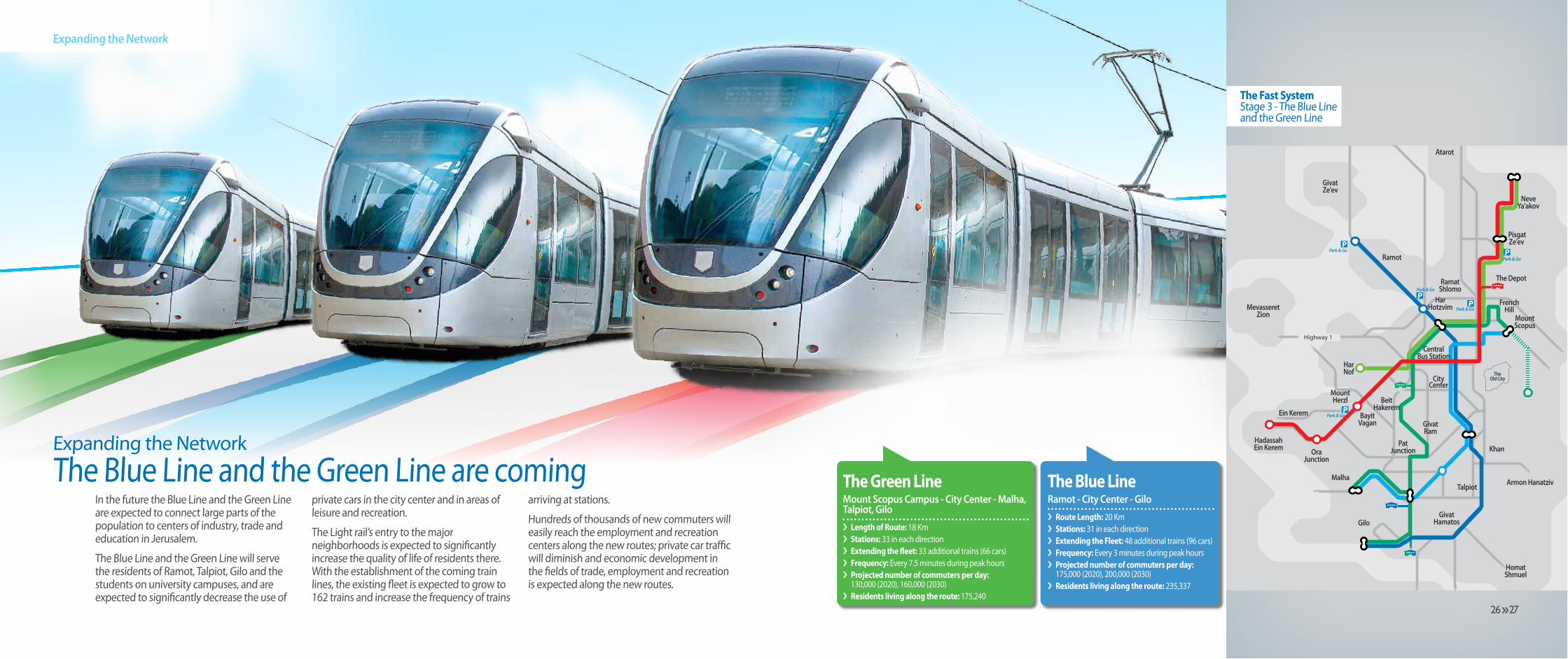
Expanding the NetworkThe Blue Line and the Green Line are coming
Expanding the Network
The Fast SystemStage 3 - The Blue Line and the Green Line
In the future the Blue Line and the Green Line are expected to connect large parts of the population to centers of industry, trade and education in Jerusalem.
The Blue Line and the Green Line will serve the residents of Ramot, Talpiot, Gilo and the students on university campuses, and are expected to significantly decrease the use of
private cars in the city center and in areas of leisure and recreation.
The Light rail’s entry to the major neighborhoods is expected to significantly increase the quality of life of residents there. With the establishment of the coming train lines, the existing fleet is expected to grow to 162 trains and increase the frequency of trains
arriving at stations.
Hundreds of thousands of new commuters will easily reach the employment and recreation centers along the new routes; private car traffic will diminish and economic development in the fields of trade, employment and recreation is expected along the new routes.
The Blue LineRamot - City Center - Giloi Route Length: 20 Kmi Stations: 31 in each directioni Extending the Fleet: 48 additional trains (96 cars)i Frequency: Every 3 minutes during peak hoursi Projected number of commuters per day: 175,000 (2020), 200,000 (2030)i Residents living along the route: 235,337
The Green LineMount Scopus Campus - City Center - Malha, Talpiot, Giloi Length of Route: 18 Kmi Stations: 33 in each directioni Extending the fleet: 33 additional trains (66 cars)i Frequency: Every 7.5 minutes during peak hoursi Projected number of commuters per day: 130,000 (2020), 160,000 (2030)i Residents living along the route: 175,240
P
P
P
P
P
Park & Go
Mount Herzl
Hadassah Ein Kerem Ora
Junction
Pisgat Ze'ev
NeveYa'akov
Har Nof
Mevasseret Zion
Ein Kerem
Atarot
The Depot
Highway 1
French Hill
Mount Scopus
TheOld City
Khan
Armon Hanatziv
Homat Shmuel
Gilo
Malha
RamatShlomo
HarHotzvim
CentralBus Station
CityCenter
Talpiot
GivatHamatos
Ramot
GivatRam
PatJunction
GivatZe'ev
BeitHakerem
BayitVagan
Park & Go
Park & Go
Park & Go
Park & Go
hh27 26
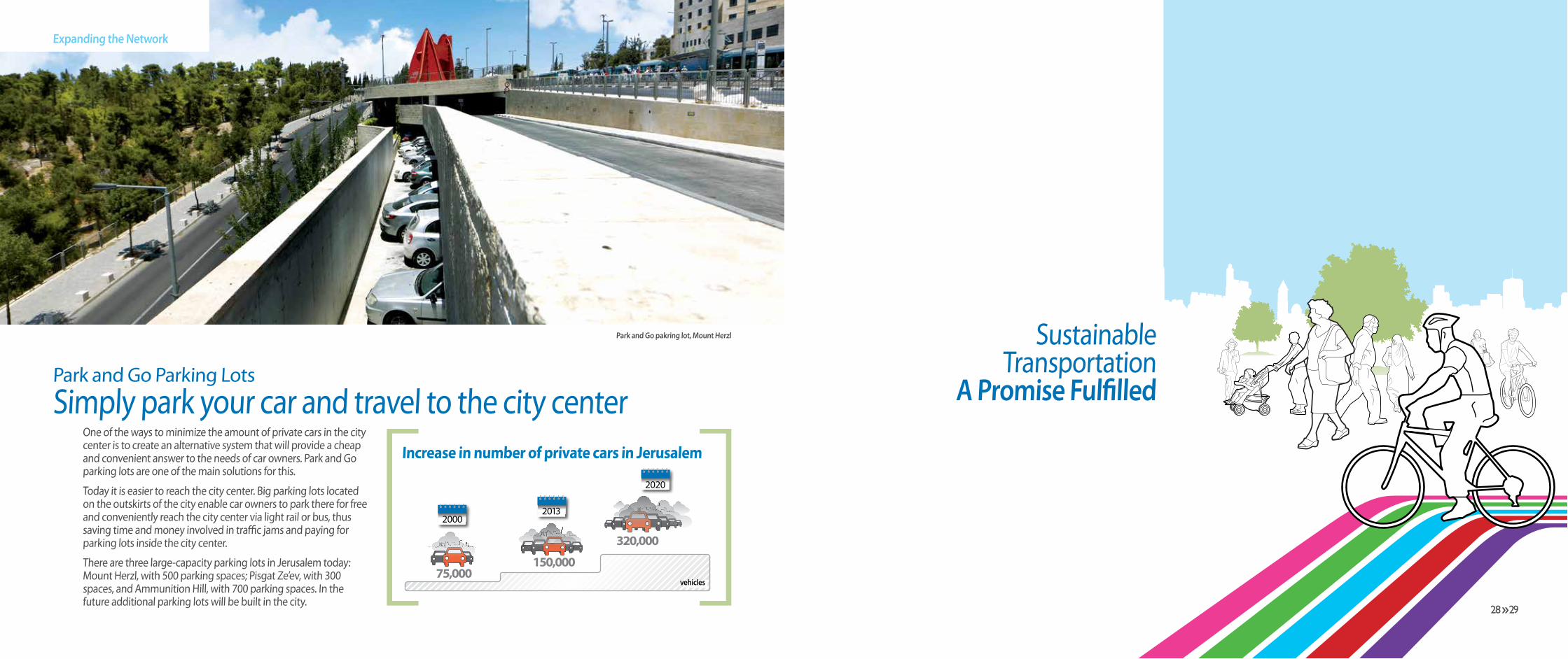
Park and Go Parking LotsSimply park your car and travel to the city center
One of the ways to minimize the amount of private cars in the city center is to create an alternative system that will provide a cheap and convenient answer to the needs of car owners. Park and Go parking lots are one of the main solutions for this.
Today it is easier to reach the city center. Big parking lots located on the outskirts of the city enable car owners to park there for free and conveniently reach the city center via light rail or bus, thus saving time and money involved in traffic jams and paying for parking lots inside the city center.
There are three large-capacity parking lots in Jerusalem today: Mount Herzl, with 500 parking spaces; Pisgat Ze’ev, with 300 spaces, and Ammunition Hill, with 700 parking spaces. In the future additional parking lots will be built in the city.
Expanding the Network
Park and Go pakring lot, Mount Herzl
Increase in number of private cars in Jerusalem
20002013
2020
320,000
150,00075,000
vehicles
Sustainable Transportation
A Promise Fulfilled
hh29 28

Sustainable Transportation
The renovated pedestrian Jaffa Street
Painting the city greenThe grime in Jaffa Street gave way to a green boulevard of trees; traffic lanes on Herzl Avenue are decorated with flowering gardens and trees, and the honks of car horns gave way to street musicians.
A clean environment, with fresh mountain air, streets which are a pleasure to walk and an atmosphere encouraging sporting
activities are one of the main aspirations of the Jerusalem Transport Management Team. In order to achieve this we make an effort to reduce the number of private cars in the city, to encourage the use of clean public transportation, bicycles and walking, and to bring out the city's beautiful views.
Sustainable transportation is a concept
combining use of public transportation, private cars and unmotorized means of transport, by paving bicycle routes, wide sidewalks, quiet pedestrian streets and exclusive public transportation lanes taking commuters on a journey through the beautiful mountainous views surrounding the city.
The renovated Zion Square
Reduction in pollution in Jaffa StreetNOx levels before and after operation of the light rail
HoursNOx - Carbon monoxide emissions - is one of the main pollutants ejected from vehicles using fossil fuels
February 2011February 2012
NOx c
once
ntra
tion
(in m
l.)
hh31 30
N
Hanevi'im
King Solomon
Strauss
King Geo
rge
Hillel
Hama'alot
Agripas
Bezalel
Ben Yehuda
Ben Hillel
Schatz
Bezalel
Rivlin
Salomon
Lunz
Horkanos
Ben Shatah
Davidka
ClalBuilding
EvenIsrael
SafraSquare
MahaneYehuda
Nachlaot
ZionSquare
Rehavia
RussianCompound
Independence Park
Elias
h
Shami
Koresh
Harav Kook
Hahavetzelt
Heleny Hamalka
Shm
uel H
anag
id
Ya'avetz
Agron
Jaffa Street
Jaffa Street
Even
Israe
l
Sustainable Transportation
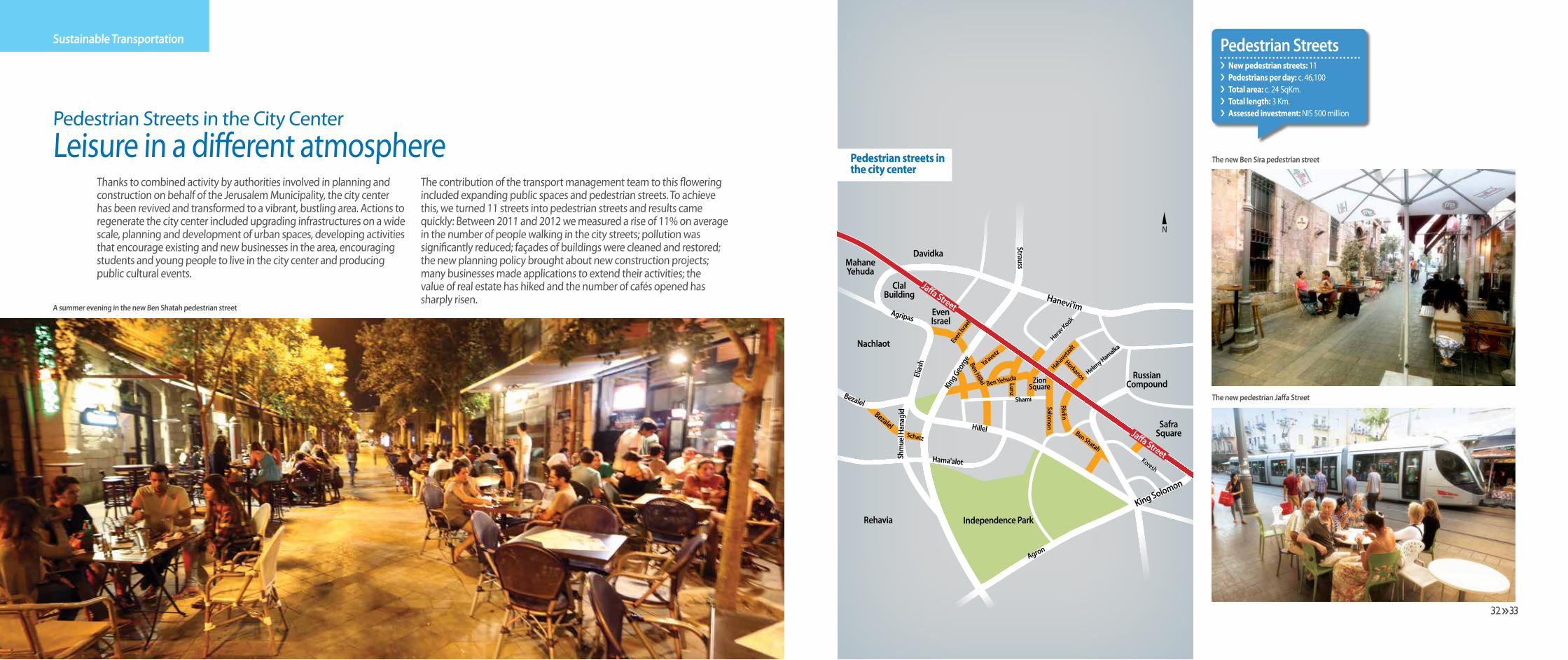
Thanks to combined activity by authorities involved in planning and construction on behalf of the Jerusalem Municipality, the city center has been revived and transformed to a vibrant, bustling area. Actions to regenerate the city center included upgrading infrastructures on a wide scale, planning and development of urban spaces, developing activities that encourage existing and new businesses in the area, encouraging students and young people to live in the city center and producing public cultural events.
The contribution of the transport management team to this flowering included expanding public spaces and pedestrian streets. To achieve this, we turned 11 streets into pedestrian streets and results came quickly: Between 2011 and 2012 we measured a rise of 11% on average in the number of people walking in the city streets; pollution was significantly reduced; façades of buildings were cleaned and restored; the new planning policy brought about new construction projects; many businesses made applications to extend their activities; the value of real estate has hiked and the number of cafés opened has sharply risen.
A summer evening in the new Ben Shatah pedestrian street
The new Ben Sira pedestrian street
The new pedestrian Jaffa Street
Pedestrian Streets in the City CenterLeisure in a different atmosphere Pedestrian streets in
the city center
Pedestrian Streetsi New pedestrian streets: 11i Pedestrians per day: c. 46,100 i Total area: c. 24 SqKm.i Total length: 3 Km.i Assessed investment: NIS 500 million
hh33 32

Ecological planning has only recently become a basic principle in urban planning in Israel. The increasing use of bicycles as a means of transportation and recreation has become a central aspect in urban planning. The team has greatly assisted in planning the network of routes from the neighborhoods to the light rail stations and in connecting those routes to other recreational and sporting bicycle routes in the city.
Today there are dozens of kilometers of bicycle routes in the city, and they serve thousands of cyclists who use them to get to work, for leisure riding or for sports.
In the future, lanes are planned to connect neighborhoods to the city center and to business and leisure centers. They will all connect to a continuous circular road more than 42 Km. long in the Jerusalem Park.
Bicycle parking near a light rail station
Bicycle route in Park Hamesilla
Route surrounding Jerusalem, in Jerusalem Park
Pedestrian and Bicycle RoutesWalking to a greener future
Sustainable Transportation
Innovation in Jerusalem Transportation
hh35 34

Jerusalem has been blessed with a uniquely diverse population. Infrastructure work carried out in a dense urban area - near homes and businesses - as well as the need to change the public’s commuting habits, all necessitated that the team invest much thought in the field of communication and advertising, in order to facilitate residents’ and users’ orientation in the new system.
The residents are at the heart of the concept developed by the team. They are seen as participants in planning and their needs are taken into account as much as possible.
For this end, communication and press units were established as a means for direct dialog with residents and for explaining to the public the expected changes, each demographic in the method most appropriate for it.
These units accompany the residents and planners from the early drafts, through approval by different ministries, the municipality and planning committees, all the way to implementation, launching new projects and day to day operation.
The dialogue between planning and implementation representatives and the public continues all the time. A team of experts initiated meetings with residents, and discussion with neighborhood planning engineers and community leaders. When changes are implemented, residents are informed by different media outlets - pamphlets distributed to mailboxes, stewards who explain the changes in transportation and community centers, newspaper ads and social media publications.
The methods of involving and informing the public were studied and implemented by similar teams throughout the country.
Night lines - buses safely bringing youths from the city center back home during the night hours - started as a Transportation Ministry initiative looking for a way to combat accidents caused by fatigue and driving under the influence. The lines were planned and managed by the Jerusalem Transport Management Team , which sought to create a convenient, reliable and cheap public transportation system that would appeal to youngsters and be a real alternative to using private vehicles. The lines operate during the year over weekends and holidays only. Following its success, the project was implemented throughout the country.
In Metropolitan Jerusalem there are ten night lines currently in operation, and they annually bring tens of thousands of youths from neighborhoods to the city center and back home, as well as to communities around Metropolitan Jerusalem and to Tel Aviv.
The success of the lines lies in the unique alternative they present to driving after drinking and by creating a viable alternative to the dangerous use of private cars. As a result, the number of accidents involving young drivers has dropped and recreational activities became accessible also to youths not privileged with having a car.
A report by the Knesset’s Information and Research Center published some time ago shows that where night lines are in operation there has been a significant drop in injuries caused by car accidents.
In order to draw youths to the service, the transport management invested in branding the service including the owl logo, which has become a national celebrity. Following the success of the initative in Jerusalem the service has been extended to other cities in Israel, from Naharia to Eilat, including Metropolitan Haifa and Metropolitan Tel Aviv.
Night LinesA great solution for the wee hours
Informing the PublicThe residents become participants
Innovation in Jerusalem Transportation
A steward explains changes in line routeshh37 36 hh37 36

East Jerusalem OperatorsImproving the quality of service
Roads and RoutesAll Roads Lead
to Jerusalem
Innovation in Jerusalem Transportation
The Jerusalem Transport Management Team works under the directive of the Transportation Ministry and jointly with ‘East Jerusalem Operators’ to unify the transportation system in the city and to improve service to all residents. This is based on meticulous planning, quality concerns and the creation of a unique brand.
The East Jerusalem Operators association unites 15 different operators working in east Jerusalem neighborhoods.
Until 2003 these operators worked independently without coordination, in antiquated buses and without criteria of service, consistent timetables or safety norms. In addition, 1200 pirate taxis were carrying most of the commuters and they created traffic chaos in the urban centers of east Jerusalem.
The ‘East Jerusalem Operators’ association has significantly improved the quality and level of service in the eastern part of the city, and brought about a dramatic increase in the number of commuters among the area’s residents. In 2010 the number of daily trips
in organized public transportation has vastly increased and the number of commuters per day has risen from 18,000 in 1998 to 93,000in 2010.
As part of the reorganization of public transportation in the eastern part of the city, central stations in the area were renovated and upgraded and a new station for south Jerusalem lines has been opened. In the future hundreds of new bus stops will be installed along the routes of east Jerusalem lines. This will be the first time where advanced software for managing and improving a bus fleet is used in east Jerusalem.
hh39 38

Cutting distances in Jerusalem
The unique topography of Jerusalem poses unique planning challenges to the transport management team: Mountains, population centers located far apart from one another, and one city center. These factors combine to create a real challenge for integrating between means of transportation and for creating a transportation infrastructure.
The set of ring roads that will encircle the city is one of the solutions initiated by the transport management team for connecting the different parts of the city and for direct access to the exits out of it.
Paving the eastern ring road and Road 16 will complete the planned traffic continuity and will enable driving from one end of the city to the other. Also, completing the ring road will enable residents of distant neighborhoods and suburbs speedy entry to the city and exit out of it.
The cross-town roads - Begin Road and the urban Route 1- are pat of the city’s central traffic spinal cord and together with the ring road will enable lessened congestion and a more flowing traffic. The cross-town roads as well as the ring roads are supported by engineering solutions like tunnels and bridges and this set of roads will enable interfacing with the mass transportation system through Park and Go parking lots.
Tens of thousands of people make their way to and from Jerusalem every day for work, pleasure, studies and tourism. The growth in the number of people entering the city has created heavy congestion in the arterial roads leading in and out of the city.
The Jerusalem Transport Management Team is working to lighten congestion inside the city and in the roads leading to it. For this end we have planned new entries to the city like Route 9 (which has been paved) and Route 16 from Motza Interchange to Givat Mordechai Interchange (which will be finished within the next five years by the Israel Roads company); main cross-town roads like Begin Road; and a set of ring roads allowing private cars to get from one end of town to another without entering residential areas and while completely integrating with the mass transportation system, through a network of Park and Go parking lots near the junctions that connect main roads and light rail lines. The new Road 9 tunnels in Emek Arazim
Cross-town routes and ring roads
Roads and Routes
hh41 40
Roads and Routes
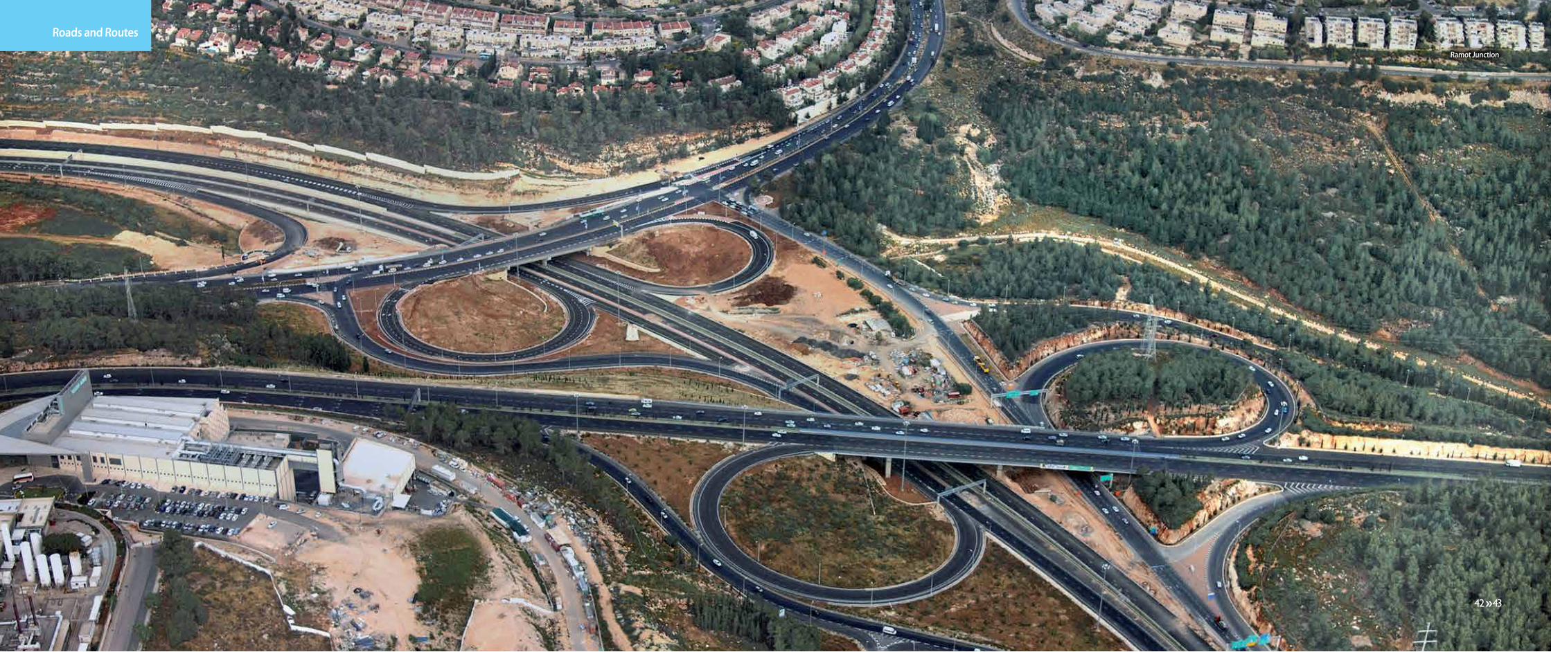
Ramot Junction
hh43 42 hh43 42
Roads and Routes
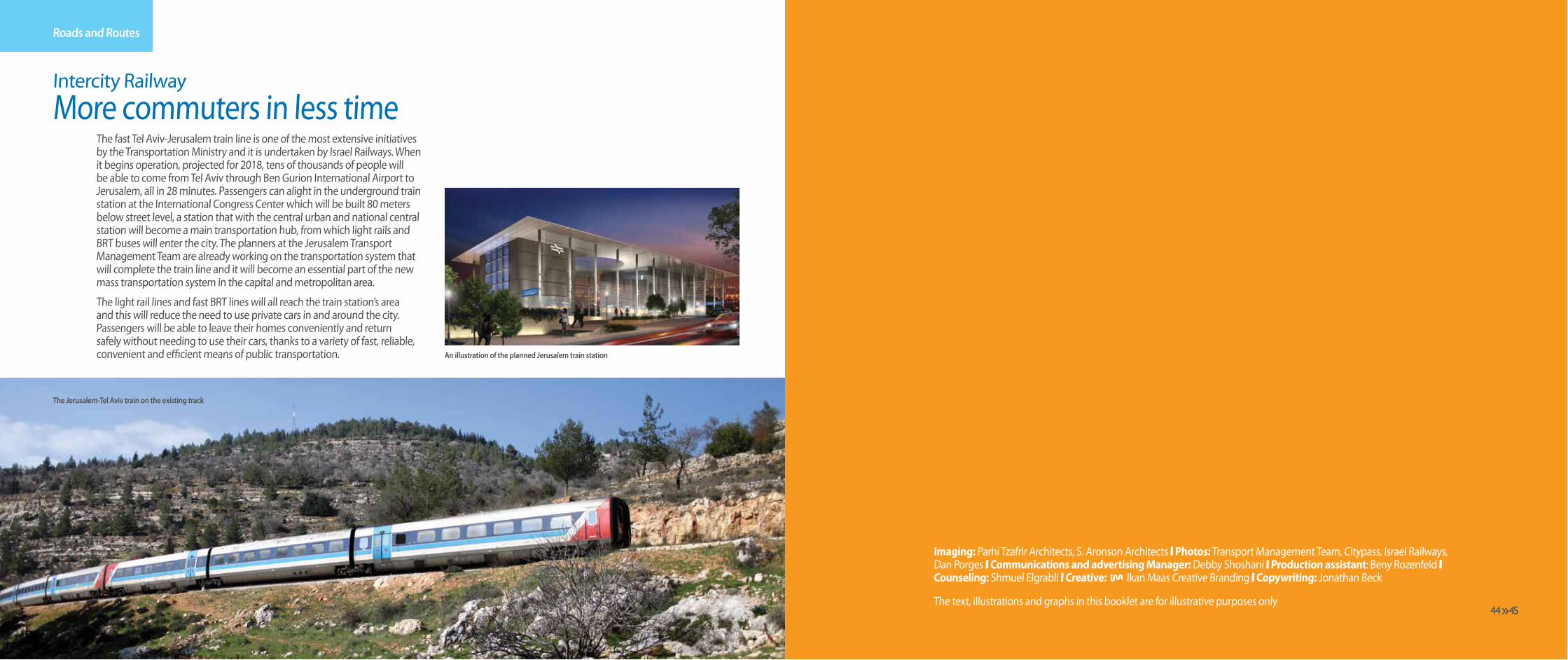
The fast Tel Aviv-Jerusalem train line is one of the most extensive initiatives by the Transportation Ministry and it is undertaken by Israel Railways. When it begins operation, projected for 2018, tens of thousands of people will be able to come from Tel Aviv through Ben Gurion International Airport to Jerusalem, all in 28 minutes. Passengers can alight in the underground train station at the International Congress Center which will be built 80 meters below street level, a station that with the central urban and national central station will become a main transportation hub, from which light rails and BRT buses will enter the city. The planners at the Jerusalem Transport Management Team are already working on the transportation system that will complete the train line and it will become an essential part of the new mass transportation system in the capital and metropolitan area.
The light rail lines and fast BRT lines will all reach the train station’s area and this will reduce the need to use private cars in and around the city. Passengers will be able to leave their homes conveniently and return safely without needing to use their cars, thanks to a variety of fast, reliable, convenient and efficient means of public transportation.
Imaging: Parhi Tzafrir Architects, S. Aronson Architects \ Photos: Transport Management Team, Citypass, Israel Railways, Dan Porges \ Communications and advertising Manager: Debby Shoshani \ Production assistant: Beny Rozenfeld \ Counseling: Shmuel Elgrabli \ Creative: Ikan Maas Creative Branding \ Copywriting: Jonathan Beck
The text, illustrations and graphs in this booklet are for illustrative purposes only
The Jerusalem-Tel Aviv train on the existing track
An illustration of the planned Jerusalem train station
Intercity RailwayMore commuters in less time
hh45 44
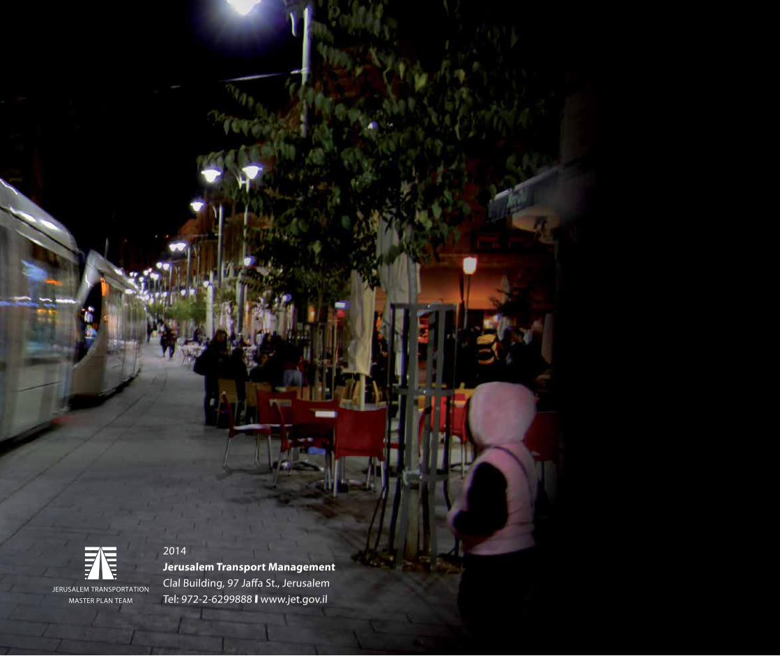
2014Jerusalem Transport ManagementClal Building, 97 Jaffa St., JerusalemTel: 972-2-6299888 \ www.jet.gov.il
46