shepparton irrigation region water supply protection · pdf filesalinity and water table...
TRANSCRIPT

G-MW Docs Ref: 1986207
Shepparton Irrigation Region Water Supply Protection Area
Management Plan (Groundwater)
REPORT FOR THE YEAR ENDED JUNE 2006
Shepparton Irrigation Region WSPA (Groundwater) Report for Year Ended June 2006
G-MW Docs Ref: 1986207 i
Foreword This report is submitted to the Minister for Water, the Goulburn Broken Catchment Management Authority and the North Central Catchment Management Authority in accordance with Section 32C of the Water Act 1989. A copy of this report is available for inspection at the Tatura office of Goulburn-Murray Water (G-MW), or upon request. A notice of report availability will also be published as required by Section 32D of the Water Act 1989. The purpose of this report is to detail activities of G-MW in administering and enforcing the management plan, and provide information that is required to be reported under the Plan. Area Shepparton Irrigation Region Water Supply
Protection Area (SIRWSPA)
Segment Groundwater
Area Declared September 1995
Plan Approved 1999
Scheduled Plan Review No review date specified in the plan
Implementation Authority Goulburn-Murray Water
Relevant CMA Goulburn Broken Catchment Management Authority and North Central Catchment Management Authority
Report Period 1 July 2005 – 30 June 2006 Since approval of the Management Plan in 2003, Goulburn-Murray Water has achieved many plan requirements including implementation of a metering and monitoring program. Implementing elements of the management plan in some cases requires longer term planning, consultation and negotiations with landholders and G-MW is actively progressing towards completion of these elements. During any year, new operational issues may also arise and impact on plan implementation. These issues, such as new bores requiring meter fitting, are dealt with as they arise. This report identifies the following issues that require consideration by G-MW and the Department of Sustainability and Environment (DSE) relating to the implementation of the Groundwater Management Plan: 1. The owners of four licensed bores had previously refused G-MW access for
metering purposes during the 2004/2005 irrigation year. One of these bores has since been found not to be used and does not require metering. During 2005/2006 G-MW sent written notification to the owners of the remaining three bores outlining metering requirements for licensed groundwater as required under the Water Act 1989. G-MW has also undertaken site visits to discuss these legal obligations with the relevant licensees. G-MW has now made successful arrangements with the licensees for property access to install meters on these outstanding bores.
2. Forty metered bores had a recorded usage in excess of licence entitlement, which is significantly fewer than the ninety-one recorded last year. The groundwater used over entitlement by these bores comprises less that one third of the volume used in

Shepparton Irrigation Region WSPA (Groundwater) Report for Year Ended June 2006
G-MW Docs Ref: 1986207 ii
excess of entitlement during 2004/2005. Following the three year transition period towards use within entitlement, which commenced 1 July 2002 and ended on 30 June 2005, compliance to use within licence entitlement has been expected and communicated to all groundwater stakeholders within the SIRWSPA on an annual basis. Groundwater usage data suggests this communication strategy has been effective. Use within entitlement will continue to be communicated to all licence holders and those known to have exceeded entitlement will be issued a final warning by G-MW. After this warning, further failure of licensees to use within their licence entitlement will be considered by G-MW to be a continued breach of licence conditions. Such licensees are proposed to be subject to an excess use management fee, which will be developed with proposed implemented for the commencement of the 2007/2008 season. In cases of further use in excess of entitlement, G-MW may take legal action.
G-MW recognises that managing use within entitlement in the SIRWSPA must include consideration of the catchment management objectives of the Management Plan. By June 30 2007 additional tools will be developed by G-MW in consultation with the Goulburn Broken Catchment Management Authority and North Central Catchment Management Authority to ensure licensed use is managed within entitlement in a manner consistent with the objectives of the Management Plan.
3. Thirty six percent of licensees complied with G-MW’s request for a groundwater sample during the current reporting period. This is a slight decrease (7%) on the previous reporting period 2004-2005 and G-MW is endeavouring to improve compliance with the salinity sampling program by providing feedback to licensees on the sample results. G-MW will also aim to improve understanding by providing information to licensees outlining the purpose and benefits of collecting groundwater data and highlighting the importance of contributing to this information.
4. G-MW monitors shallow groundwater levels across the SIRWSPA through a network of 3,800 groundwater observation bores. A watertable map is produced annually based on winter (August) shallow groundwater levels.
There has been some rise in the watertable between August 2004 and August 2005. The Rochester and Central Goulburn Irrigation Areas have experienced a slight expansion in the areas bounded by the 2m and 1m watertable contours while the Murray Valley Irrigation Area has experienced a slight expansion in the areas bounded by the 3m, 2m and 1m watertable contours. This is likely as a result of the greater than average rainfall recorded in various locations across the region in the 12 months to August 2005.
These results reflect the continued risk to land productivity in those areas of the SIR WSPA and reinforce the need to adhere to the Groundwater Management Plan salinity and water table control measures.
Signed
(signed 2 October 2006) Russell Cooper Chief Executive

Shepparton Irrigation Region WSPA (Groundwater) Report for Year Ended June 2006
G-MW Docs Ref: 1986207 1
INDEX 1. Introduction.......................................................................................................................... 1
1.1. The Region................................................................................................................... 1 1.2. Hydrogeology............................................................................................................... 2 1.3. Salt Disposal ................................................................................................................ 3
2. Goulburn-Murray Rural Water Authority’s Duties under the Groundwater Management Plan. ............................................................................................................... 4
3. Works Program.................................................................................................................... 5 4. Allocations at 30 June 2005 ................................................................................................ 6 5. Metering................................................................................................................................ 7 6. Groundwater Monitoring and Reporting ......................................................................... 10
6.1. Groundwater Monitoring Costs .................................................................................. 10 7. Transfer of Water Entitlement .......................................................................................... 11 8. Data Review........................................................................................................................ 12
8.1. Groundwater Level Trends ........................................................................................ 12 8.2. Groundwater Salinity.................................................................................................. 12
9. Concluding Remarks......................................................................................................... 14 9.1. Overuse of Entitlement .............................................................................................. 14 9.2. Response from Request for Groundwater Samples.................................................. 14
Shepparton Irrigation Region WSPA (Groundwater) Report for Year Ended June 2006
G-MW Docs Ref: 1986207 1
1. Introduction
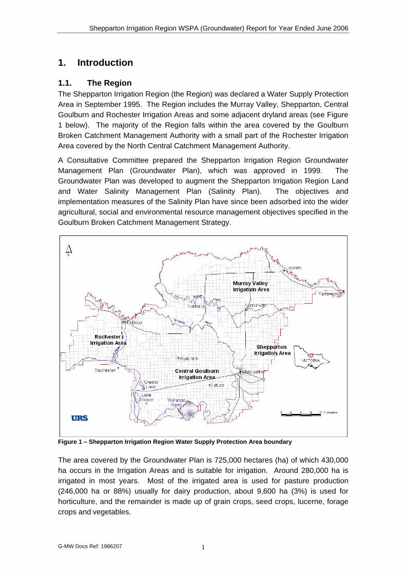
1.1. The Region The Shepparton Irrigation Region (the Region) was declared a Water Supply Protection Area in September 1995. The Region includes the Murray Valley, Shepparton, Central Goulburn and Rochester Irrigation Areas and some adjacent dryland areas (see Figure 1 below). The majority of the Region falls within the area covered by the Goulburn Broken Catchment Management Authority with a small part of the Rochester Irrigation Area covered by the North Central Catchment Management Authority.
A Consultative Committee prepared the Shepparton Irrigation Region Groundwater Management Plan (Groundwater Plan), which was approved in 1999. The Groundwater Plan was developed to augment the Shepparton Irrigation Region Land and Water Salinity Management Plan (Salinity Plan). The objectives and implementation measures of the Salinity Plan have since been adsorbed into the wider agricultural, social and environmental resource management objectives specified in the Goulburn Broken Catchment Management Strategy.
Figure 1 – Shepparton Irrigation Region Water Supply Protection Area boundary The area covered by the Groundwater Plan is 725,000 hectares (ha) of which 430,000 ha occurs in the Irrigation Areas and is suitable for irrigation. Around 280,000 ha is irrigated in most years. Most of the irrigated area is used for pasture production (246,000 ha or 88%) usually for dairy production, about 9,600 ha (3%) is used for horticulture, and the remainder is made up of grain crops, seed crops, lucerne, forage crops and vegetables.
Shepparton Irrigation Region WSPA (Groundwater) Report for Year Ended June 2006
G-MW Docs Ref: 1986207 2
Of the approximate 7,300 farms within the Irrigation Areas, 3,600 (49%) are “mixed” farms, 3,100 (42%) are dairy farms and 650 (9%) are horticultural farms.
The Region is one of the major food processing areas of Australia with large local and international companies such as Kraft, Bonlac, Plumrose, Nestlé, Unilever (Rosella), Tatura Milk, Murray-Goulburn, SPC-Ardmona, Leggos, Campbell Soups and Girgarre Foods (Heinz) established within its boundaries.
However, the economic benefits to the region, state and nation brought about by widespread irrigation practises in the Region over the last century have come at an environmental cost. The cost is manifest in high, shallow groundwater tables, saline groundwater and associated environmental degradation.
Other groundwater management plans have been developed to manage groundwater resources from overuse that could result in excessive declines in groundwater pressures within those Groundwater Management Areas covered by their associated plans.
The Groundwater Plan is unique to Victoria by comparison to other groundwater management plans in both its intent and management measures.
Section 2 of the Groundwater Plan states: “The primary objective of this Plan is to support the implementation of the Salinity Plan which aims to protect the Region's agricultural productivity and natural resources. It will do this by encouraging and supporting regular and responsible pumping of groundwater to provide salinity control while protecting both the groundwater resource and the rights of groundwater resource users.”
Goulburn Murray Water Authority’s primary interest includes equitable management of the groundwater resource to allow sustainable usage of that resource within licence conditions.
The Goulburn Broken Catchment Management Strategy focuses more particularly on encouraging regular groundwater pumping to provide salinity and partial groundwater control. It encourages groundwater use within agreed salinity limits which are designed to encourage sustainable land and water management practises.
The Groundwater Plan does not have a Permissible Annual Volume (PAV) against which licence entitlements are measured. Groundwater level monitoring is not undertaken with the specific aim of tracking where excessive declines in groundwater levels are occurring, rather monitoring is undertaken to allow watertable and salinity control works to be targeted in the high risk, high watertable areas.
1.2. Hydrogeology The riverine plains of the Shepparton Region are alluvial deposits which have a comparatively flat surface. The depth of alluvium above bedrock varies, typically ranging from 20 metres to 120 metres with a maximum recorded thickness of 250 metres. The nature of the sub-surface strata is complex.
The alluvial deposits are divided into three principal geological units: the Renmark Group, the Calivil Formation and the Shepparton Formation.
Shepparton Irrigation Region WSPA (Groundwater) Report for Year Ended June 2006
G-MW Docs Ref: 1986207 3
The Renmark Group and Calivil Formation (often considered the one hydrogeological unit) are unconsolidated gravels and sands which lie unconformably upon weathered pre-Cainozoic basement rock. These sediments were deposited during the Tertiary period along broad valleys by rivers flowing from the highlands onto the plain. The Renmark Group/Calivil Formation form three major aquifers that generally follow the course of today’s Murray, Goulburn and Campaspe Rivers (commonly referred to as “Deep Leads”). These aquifers broaden toward the north and west and merge to form a continuous sheet under much of the south-eastern Murray Basin.
The Shepparton Formation overlies the Calivil/Renmark aquifer and forms the uppermost geological formation (usually 80 to 100 metres thick) over most of the region. The Shepparton Formation predominantly comprises alluvial silts and clays interspersed with meandering channels of sands and gravels, typically up to 5 m thick, and often discontinuous. The aquifers of sand and gravel are locally capable of supplying significant quantities of water. However, due to the highly variable lithology of the Shepparton Formation, the occurrence of good quality groundwater available in useful quantities is highly irregular. For management purposes the unit is often divided into the Upper and Lower Shepparton Formation.
As defined by the Groundwater Plan, aquifers which are wholly or in part within 25 metres of surface are defined as "shallow aquifers", and aquifers at greater depths than that are defined as "deep aquifers". Since the Groundwater Plan was approved in 1999, the Katunga and Campaspe Groundwater Management Plans have been developed covering the deep lead aquifers in the Murray Valley and Campaspe regions of the Region respectively. The Groundwater Plan has not been modified to reflect the management supersedence relating to the deep lead aquifers in the SIRWSPA.
1.3. Salt Disposal The Salinity Plan was developed with the aim of managing shallow groundwater levels and land salinity in the Region. As discussed above, an important outcome of the Salinity Plan has been the establishment of the Groundwater Plan for the SIRWSPA. The main aim of the Groundwater Plan is to manage private irrigation groundwater use to ensure sustainability of the regions land and water resources. The secondary aim of the Groundwater Plan is to equitably manage the groundwater resource.
One of the key aspects of the Groundwater Plan is its role in management of salt disposal from the Region. The Region is able to export salt under the Murray Darling Basin Drainage Strategy, and private groundwater bores provide a large part of the region’s salt disposal capacity. This capacity is available in requiring certain registered bores (referred to as Salinity Plan Bores – SPB) to operate for salt disposal during the winter provided that a given trigger flow occurs in the Murray River at Torrumbarry Weir. There were 222 of these bores registered by GMW at 30 June 2006 having a total potential to dispose of 6,300 ML and in the order of 9230 tonnes of salt from the Region annually.
The Victorian Government reports annually to the Murray Darling Basin Commission on salt disposal.
Shepparton Irrigation Region WSPA (Groundwater) Report for Year Ended June 2006
G-MW Docs Ref: 1986207 4
2. Goulburn-Murray Rural Water Authority’s Duties under the Groundwater Management Plan.
Goulburn-Murray Rural Water Authority (G-MW) is the authority responsible for managing and administering the Groundwater Plan.
The Groundwater Plan requires that G-MW undertake:
• groundwater volumetric usage meter fitting to all licensed irrigation bores existing prior to 1 July 1999 with usage of >20ML/a at the cost of G-MW (note that bores installed for licensed use since 1 July 1999 must be metered at the licensee’s cost)
• groundwater volumetric usage meter reading – post irrigation (summer) season;
• groundwater volumetric usage meter reading – winter salt disposal allocation (SDA) season (when disposal conditions are favourable);
• groundwater level monitoring;
• groundwater level reporting (August watertable map production);
• groundwater salinity assessments;
• administering groundwater licensing within the prescriptions of the Groundwater Plan; and
• review and report annually to the Minister administering the Water Act (1989) on the prescribed activities of the plan
A Working Group has been established to assist in the implementation of the Groundwater Plan. The Groundwater Plan is nearing completion of its implementation phase. This report is the sixth annual report to the Minister and presents the outcome of the above key activities undertaken in the period 1st July 2005 to 30th June 2006.
Shepparton Irrigation Region WSPA (Groundwater) Report for Year Ended June 2006
G-MW Docs Ref: 1986207 5
3. Works Program The required works program in accordance with the Groundwater Plan and completion dates are shown in the table below:
Works 99/00 00/01 01/02 02/03 03/04 04/05 05/06 06/07
Meters Fitted: Installation Program1
205 109 41 0 14 57 6 Ongoing2
Meter Reading (summer season)
Done Done Done Done Done Done Done Ongoing
Meter Reading (winter season)
N/A3 N/A N/A N/A N/A N/A N/A Ongoing
Groundwater Level Monitoring
Done Done Done Done Done Done Done Ongoing
August Watertable Map Reporting
Done Done Done Done Done Done Done Ongoing
Groundwater Salinity Assessment
Done Done Done Done Done Done Done Ongoing
Groundwater Licence Administration
Done Done Done Done Done Done Done Ongoing
Annual Reporting to the Minister
Done Done Done Done Done Done Done Ongoing
1 Refer to Dot Point 1 in Section 2. 2 All bores that meet the criteria have been metered with the exception of three bores whose owners initially refused
access during 2004/2005. Arrangements are now being made with the licensees for property access to install meters on these outstanding bores.
3 Winter pumping did not occur due to low dilution flows in the Murray River.

Shepparton Irrigation Region WSPA (Groundwater) Report for Year Ended June 2006
G-MW Docs Ref: 1986207 6
4. Allocations at 30 June 2006 The following table includes the groundwater licence entitlement volumes allocated to June 2006 for extractive use purposes.
Column 1 Column 2 Column 3 Column 4 Column 5
WSPA Total No. Licences
Licensable (ML)
Domestic & Stock (ML)
Watertable & Salinity
Control (ML)
Total (ML)
Shepparton Irrigation Region 1,373 201,131 852 22,243 224,226
Notes: Column 1 Number of Licences Column 2 Total volume of groundwater allocated under licence (excludes Domestic &
Stock). Irrigation use entitlements total 200,144 ML (99.5%) of the licensable total.
Column 3 Domestic & stock allowance Column 4 Includes Public Pump and Private Salinity Plan bores licensed for off site
disposal of groundwater for watertable and salinity control purposes. Column 5 Total groundwater allowance
Figure 2 below shows the distribution of the licensed groundwater extraction bores summarised in the table above.
Figure 2 - The distribution of licensed groundwater extraction bores in the SIRWSPA
Shepparton Irrigation Region WSPA (Groundwater) Report for Year Ended June 2006
G-MW Docs Ref: 7
5. Metering
Volumetric flow meters are required to be fitted at the owner’s expense to all new licensed groundwater irrigation bores. The meters are to be fitted to meet G-MW’s specifications. All private dewatering bores are also fitted with a volumetric flow meter.
In accordance with the Groundwater Plan, all licensed irrigation bores with an annual usage of more than 20 ML4 installed prior to 1 July 1999 have had funding provided for the supply and fitting of a G-MW approved volumetric flow meter.
Summer Groundwater Extraction
Eight hundred and seventy (870) licensed irrigation bores were fitted with a volumetric flow meter at the end of the reporting period. Of these, the number verified as having reliable usage data for the full reporting period totalled 789. The majority of the remaining 81 bores had meters installed during the reporting period and therefore did not have verified base meter readings. Data from meters assessed as being reliable are considered to be representative of groundwater use in the reporting period. Metering data is stored and maintained by G-MW.
The following table sets out the volume used as recorded by fully operational meters for the year to June 2006.
Column 1 Column 2 Column 3
WSPA Total No. Metered Bores
Metered Bore
Entitlement (ML)
Metered Bore Use
(ML)
Shepparton Irrigation Region 789 156,984 62,752
Notes: Column 1 Number of licensed irrigation bores fitted with a meter that have been verified
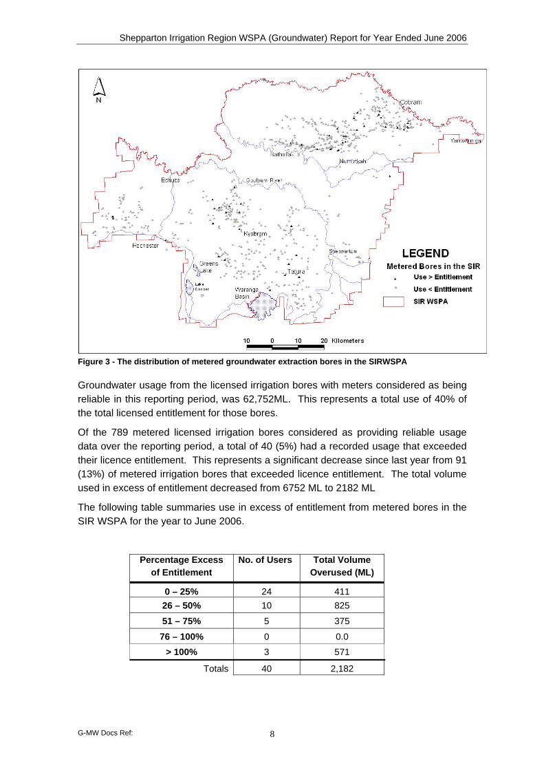
as being operational for the full reporting period. Column 2 Total licensed entitlement of the bores numbered in Column 1 Column 3 Total volume of metered groundwater use of bores numbered in Column 1 Figure 3 overleaf shows the distribution of licensed irrigation bores that supplied data summarised in the table above.
4 20 ML is the annual groundwater usage defined as the upper limit for low capacity bores in the SIR and is a figure
endorsed by the SIR Groundwater Management Plan Working Group in 2000.
Shepparton Irrigation Region WSPA (Groundwater) Report for Year Ended June 2006
G-MW Docs Ref: 8
Figure 3 - The distribution of metered groundwater extraction bores in the SIRWSPA
Groundwater usage from the licensed irrigation bores with meters considered as being reliable in this reporting period, was 62,752ML. This represents a total use of 40% of the total licensed entitlement for those bores.
Of the 789 metered licensed irrigation bores considered as providing reliable usage data over the reporting period, a total of 40 (5%) had a recorded usage that exceeded their licence entitlement. This represents a significant decrease since last year from 91 (13%) of metered irrigation bores that exceeded licence entitlement. The total volume used in excess of entitlement decreased from 6752 ML to 2182 ML
The following table summaries use in excess of entitlement from metered bores in the SIR WSPA for the year to June 2006.
Percentage Excess of Entitlement
No. of Users Total Volume Overused (ML)
0 – 25% 24 411 26 – 50% 10 825
51 – 75% 5 375
76 – 100% 0 0.0
> 100% 3 571
Totals 40 2,182
Shepparton Irrigation Region WSPA (Groundwater) Report for Year Ended June 2006
G-MW Docs Ref: 9
Winter Groundwater Extraction & Disposal
Winter groundwater extraction and disposal applies to registered Salinity Plan Bores (SPBs).
SPBs are licensed irrigation bores that are required to meet special operating requirements in order to qualify registered SPB owners for financial assistance. For those bore owners who have not received assistance under government funded catchment management programs, registration of their irrigation bore as a SPB is voluntary. All irrigation bores that have received financial assistance under the government funded catchment management programs are mandatory SPBs.
All SPB operators have their annual fixed fee waived during the time their bores are operating as registered SPBs.
A special operating condition applies to SPB owners relating to winter groundwater extraction and stipulates that winter season disposal of their entitled Salt Disposal Allocation (SI), to their nominated disposal point, must be undertaken when directed by G-MW5.
There was no winter disposal during the current reporting period since the trigger dilution flow in the Murray River was not achieved.
5 This will only occur when a trigger dilution flow in the Murray River at Torrumbarry Weir is exceeded.

Shepparton Irrigation Region WSPA (Groundwater) Report for Year Ended June 2006
G-MW Docs Ref: 10
6. Groundwater Monitoring and Reporting Groundwater levels have been collected from 3,800 observation bores in the SIR WSPA groundwater observation bore network throughout the reporting period.
The Groundwater Plan specifies that a shallow aquifer watertable map be prepared annually on the basis of groundwater levels recorded in August (when impacts from irrigation are expected to be minimal). The August watertable map during the current reporting period is presented below.
Potentiometric level data resulting from observation bore monitoring were recorded in the State Groundwater Management System (GMS).
Figure 4 – Watertable contours for year ending August 2005 for the SIRWSPA
Reporting of individual groundwater observation bore hydrographs is not a requirement of the Groundwater Plan.
6.1. Groundwater Monitoring Costs The table below summarises the cost of observation bore maintenance, groundwater level monitoring and analysis and production of the August watertable map in the SIR WSPA during the current reporting period.
No. Observation Bores
Observation Bore Monitoring Behaviour Analysis
Total
3,8006 $188,655 $8,962 $197,617
6 Approximately 3,800 observation bores are monitored and maintained at varying frequencies within the SIRWSPA.
Approximately 1,772 data points were used to construct the August 2005 watertable map.
Shepparton Irrigation Region WSPA (Groundwater) Report for Year Ended June 2006
G-MW Docs Ref: 11
7. Transfer of Water Entitlement Transfer of licence groundwater entitlement (temporary or permanent) is not permitted between bores in the SIR WSPA.
Shepparton Irrigation Region WSPA (Groundwater) Report for Year Ended June 2006
G-MW Docs Ref: 12
8. Data Review
8.1. Groundwater Level Trends In August 2005 the shallow watertable levels across the SIRWSPA were generally within 3 metres of the ground surface, except for Murray Valley where there are significant areas deeper than 3 metres.
In the Rochester and Central Goulburn irrigation areas, the region bounded by the 3m watertable contour is largely unchanged from August 2004. However, between August 2004 and August 2005, there was some expansion of areas bounded by the 1 metre and 2 metre watertable contours.
In the Murray Valley, there was some expansion in the areas bounded by all three watertable contour intervals between August 2004 and August 2005.
These changes suggest that there was some recovery in the watertable across the SIRWSPA. This recovery may be attributed to higher than average rainfall occurring across the Protection Area in the twelve-month period from August 2004 to August 2005 (i.e. Annual rainfall totals in this period recorded at Tatura, Kyabram, Rochester and Cobram ranged between 5 and 20% above the historic median annual rainfall totals)
With the exception of rainfall recorded between August 2004 and August 2005, northern Victoria has generally experienced lower than average rainfall conditions since 1996. The consequence of “average” groundwater recharge conditions within the SIRWSPA is twofold:
1. lower than average natural rainfall recharge to the aquifer system and,
2. a dramatic reduction in surface water allocations to irrigators.
Since 1996, the above factors have resulted in watertable levels in the SIRWSPA that are not reflective of “average” shallow watertable conditions that would otherwise be expected.
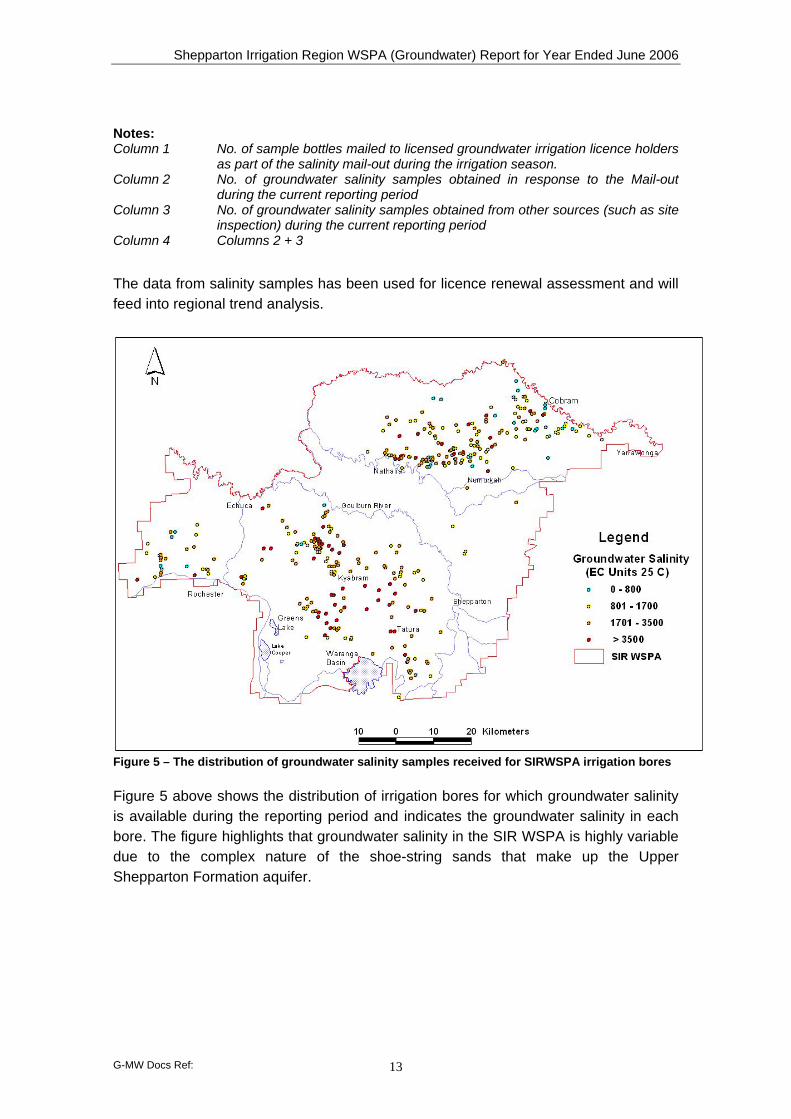
8.2. Groundwater Salinity G-MW conducts a salinity mail-out to operators of licensed irrigation bores during the irrigation season each year. A sample bottle is provided to the registered owner of all licensed shallow (ie < 25 m deep) irrigation bores within the Groundwater Plan area. Included is a pre-paid return envelope and an accompanying letter requesting that a groundwater sample be collected during operation of the irrigation bore and returned to G-MW for salinity determination (as electro-conductivity, EC).
Column 1 Column 2 Column 3 Column 4
Sample Requests
Samples from Mail-Out
Sample from Other Sources
Total No. Samples
892 324 108 432
Shepparton Irrigation Region WSPA (Groundwater) Report for Year Ended June 2006
G-MW Docs Ref: 13
Notes: Column 1 No. of sample bottles mailed to licensed groundwater irrigation licence holders
as part of the salinity mail-out during the irrigation season. Column 2 No. of groundwater salinity samples obtained in response to the Mail-out
during the current reporting period Column 3 No. of groundwater salinity samples obtained from other sources (such as site
inspection) during the current reporting period Column 4 Columns 2 + 3
The data from salinity samples has been used for licence renewal assessment and will feed into regional trend analysis.
Figure 5 – The distribution of groundwater salinity samples received for SIRWSPA irrigation bores
Figure 5 above shows the distribution of irrigation bores for which groundwater salinity is available during the reporting period and indicates the groundwater salinity in each bore. The figure highlights that groundwater salinity in the SIR WSPA is highly variable due to the complex nature of the shoe-string sands that make up the Upper Shepparton Formation aquifer.

Shepparton Irrigation Region WSPA (Groundwater) Report for Year Ended June 2006
G-MW Docs Ref: 14
9. Concluding Remarks
9.1. Overuse of Entitlement With the cessation of the transition period towards managing use within groundwater licence entitlement on 30 June 2005, G-MW has introduced stricter control measures on use in excess of groundwater licence entitlement. These control measures include a final written notice issued by G-MW. If further use in excess of entitlement occurs after this warning, G-MW will initiate a range of actions including excess usage management fees, and for instances of further use in excess of entitlement, legal action for breach of licence conditions.
Communication to all SIRWSPA licence holders occurred during 2005-2006 and reminders will continue to be issued on a yearly basis of the legal obligations in managing use within licence entitlement.
Further options to manage SIRWSPA licences will be developed by G-MW before 2007/2008, in consultation with relevant catchment management authorities, to ensure managing use within entitlement in the SIRWSPA takes into consideration the catchment strategy objectives in the SIRGMP.
9.2. Response from Request for Groundwater Samples It is a condition on groundwater irrigation licences in the SIRWSPA that licensees are required to submit a sample of groundwater from their licensed irrigation bore when requested by G-MW. G-MW are generally not able to collect samples during meter reading as meters are read annually and at the end of the irrigation season when licensed bores are typically not in operation.
Only 36% of licensees complied with G-MW’s request for a groundwater sample during the current reporting period. This is a decrease (7%) on the previous reporting period 2004-05. G-MW is endeavouring to improve compliance with the sampling program by providing feedback to licensees on salinity sample results, and seeks to improve understanding of the purpose and benefits of providing groundwater salinity data in ongoing communication with customers. Further, a communication strategy will be developed in 2006/2007 by G-MW to reinforce the benefits of customers contributing salinity samples with a view to improving the response rate.