shrimptons creek bridge hydrologic and hydraulic assessment
TRANSCRIPT

Shrimptons Creek Bridge Hydrologic and Hydraulic Assessment
Reference: L.S20319.005.01.Shrimptons Creek Bridge Assessment.docx Date: October 2018 FINAL Report

S:\WATER\PROJECTS\S20319_FIA_Ivanhoe_Estate_Redevelopment_Ryde\Docs\Report\L.S20319.005.01.Shrimptons Creek Bridge Assessment.docx
Document Control Sheet
BMT WBM Pty Ltd Suite G2, 13-15 Smail St Ultimo NSW 2007 Australia PO Box 1181, Broadway NSW 2007 Tel: +61 2 8987 2900 Fax: +61 2 8987 2999 ABN 54 010 830 421 www.bmtwbm.com.au
Document: L.S20319.005.01.Shrimptons Creek Bridge Assessment.docx
Title: Shrimptons Creek Bridge Hydrologic and Hydraulic Assessment
Project Manager: Sebastian Froude
Author: Sebastian Froude, Samuel Drysdale
Client: Frasers Property Australia
Client Contact: Joe Zannino, Cameron Jackson
Client Reference:
Synopsis: This report documents the hydrologic and hydraulic modelling undertaken to assess the current concept design of the proposed Shrimptons Creek Bridge at Ivanhoe Estate, Macquarie Park.
REVISION/CHECKING HISTORY
Revision Number Date Checked by Issued by
0 02/04/2018 SF 09/04/2018 SF 11/04/2018
1 05/10/2018 SD 05/10/2018 SF 05/10/2018 DISTRIBUTION
Destination Revision
0 1 2 3 4 5 6 7 8 9 10
Client BMT File BMT Library
e e
PDF PDF PDF
Copyright and non-disclosure notice The contents and layout of this report are subject to copyright owned by BMTWBM Pty Ltd (BMT WBM) save to the extent that copyright has been legally assigned by us to another party or is used by BMT WBM under licence. To the extent that we own the copyright in this report, it may not be copied or used without our prior written agreement for any purpose other than the purpose indicated in this report.
The methodology (if any) contained in this report is provided to you in confidence and must not be disclosed or copied to third parties without the prior written agreement of BMT WBM. Disclosure of that information may constitute an actionable breach of confidence or may otherwise prejudice our commercial interests. Any third party who obtains access to this report by any means will, in any event, be subject to the Third Party Disclaimer set out below.
Third Party Disclaimer Any disclosure of this report to a third party is subject to this disclaimer. The report was prepared by BMT WBM at the instruction of, and for use by, our client named on this Document Control Sheet. It does not in any way constitute advice to any third party who is able to access it by any means. BMT WBM excludes to the fullest extent lawfully permitted all liability whatsoever for any loss or damage howsoever arising from reliance on the contents of this report

Shrimptons Creek Bridge Hydrologic and Hydraulic Assessment iii Contents
S:\WATER\PROJECTS\S20319_FIA_Ivanhoe_Estate_Redevelopment_Ryde\Docs\Report\L.S20319.005.01.Shrimptons Creek Bridge Assessment.docx
Contents
1 Introduction 1
1.1 Background 1 1.1.1 Overview of the Proposed Stage 1 Development 1
1.2 Study Area 2
1.3 Report Purpose 2
2 Existing Information 4
2.1 Flood Impact Assessment for Ivanhoe Estate Master Plan (BMT WBM 2017) 4
2.2 Survey and Concept Bridge Design 4
3 Model Review and Development 5
3.1 Hydrologic Model 5
3.2 Hydraulic Model 5 3.2.1 Existing Scenario – Baseline Conditions 5 3.2.2 Proposed Scenario – Shrimptons Creek Bridge Conditions 5
4 Assessment of the Proposed Shrimptons Creek Bridge 8
4.1 Baseline Flood Conditions 8
4.2 Proposed Shrimptons Creek Bridge Conditions 8 4.2.1 Flood Impact Assessment 9
5 Conclusion 12
6 References 14
Appendix A Existing Condition Peak Flood Results 1
Appendix B Proposed Scenario Peak Flood Results 2
Appendix C Afflux Mapping 3
Shrimptons Creek Bridge Hydrologic and Hydraulic Assessment iv Contents
S:\WATER\PROJECTS\S20319_FIA_Ivanhoe_Estate_Redevelopment_Ryde\Docs\Report\L.S20319.005.01.Shrimptons Creek Bridge Assessment.docx
List of Figures
Figure 1-1 Ivanhoe Estate Masterplan 2
Figure 1-2 Shrimptons Creek Catchment and Topography 3
Figure 3-1 Shrimptons Creek TUFLOW Modifications 7
Figure 4-1 Result Inspection Locations 10
List of Tables
Table 3-1 Shrimptons Creek Bridge TUFLOW Structure Details 6
Table 4-1 Modelled Design Flood Levels at the proposed bridge location 8
Table 4-2 Modelled Design Flood Levels at Proposed Shrimptons Creek Bridge 8
Table 4-3 Modelled Design Velocities at Proposed Shrimptons Creek Bridge 9
Table 5-1 Shrimptons Creek Bridge Summary of Key Information 12

Shrimptons Creek Bridge Hydrologic and Hydraulic Assessment 1 Introduction
S:\WATER\PROJECTS\S20319_FIA_Ivanhoe_Estate_Redevelopment_Ryde\Docs\Report\L.S20319.005.01.Shrimptons Creek Bridge Assessment.docx
1 Introduction
This report supports a Development Application for Stage 1 of the Ivanhoe Estate redevelopment, a State Significant Development (SSD) submitted to the Department of Planning and Environment (DPE) pursuant to Part 4 of the Environmental Planning and Assessment Act 1979 (EP&A Act). It has been prepared for Aspire Consortium on behalf of NSW Land and Housing Corporation.
1.1 Background
In September 2015 the Ivanhoe Estate was rezoned by DPE as part of the Macquarie University Station (Herring Road) Priority Precinct, to transform the area into a vibrant centre that benefits from the available transport infrastructure and the precinct’s proximity to jobs, retail and education opportunities within the Macquarie Park corridor.
The Ivanhoe Estate is currently owned by NSW Land and Housing Corporation and comprises 259 social housing dwellings. The redevelopment of the Ivanhoe Estate is part of the NSW Government Communities Plus program, which seeks to deliver new communities where social housing blends with private and affordable housing, with good access to transport, employment, improved community facilities and open space.
The Communities Plus program seeks to leverage the expertise and capacity of the private and non-government sectors. As part of this program, Aspire Consortium, comprising Frasers Property Australia and Mission Australia Housing, were selected as the successful proponent to develop the site in July 2017.
In September 2017, DPE issued the Secretary’s Environmental Assessment Requirements for a comprehensive Masterplan application that will establish the framework for the staged redevelopment of the site. This Development Application for Stage 1 of the Ivanhoe Estate redevelopment represents the first stage of detailed works pursuant to the Ivanhoe Estate Masterplan.
1.1.1 Overview of the Proposed Stage 1 Development The proposed Stage 1 Development Application seeks consent for the first stage of detailed works within the Ivanhoe Estate, pursuant to the Ivanhoe Estate Masterplan under Section 4.22 of the EP&A Act. The Masterplan establishes the planning and development framework against which this Stage 1 Development Application will be assessed.
The Stage 1 Development Application seeks approval for:
• site preparation works, including tree removal, demolition of roads, services, and earthworks across the Ivanhoe Estate;
• the provision and augmentation of utilities and services infrastructure across the Ivanhoe Estate;
• the construction of all internal roads including public domain within the road reserves, and the bridge crossing and road connection to Lyonpark Road;
• the consolidation of existing lots and subdivision of the Ivanhoe Estate to reflect the revised road layout, open space, and provide superblocks corresponding to the Masterplan;

Shrimptons Creek Bridge Hydrologic and Hydraulic Assessment 2 Introduction
S:\WATER\PROJECTS\S20319_FIA_Ivanhoe_Estate_Redevelopment_Ryde\Docs\Report\L.S20319.005.01.Shrimptons Creek Bridge Assessment.docx
• the construction and use of Buildings A1 and C1 comprising residential uses (including social housing), a childcare centre, and retail / community spaces.
An image of the Masterplan, identifying Buildings A1 and C1 and illustrating the road network, is provided at Figure 1-1 below.
Figure 1-1 Ivanhoe Estate Masterplan
1.2 Study Area
The Shrimptons Creek Catchment is some 600 ha in size and consists of a number of minor tributaries draining the local suburbs of Ryde, North Ryde, Marsfield and Macquarie Park. The area surrounding the study site is typified by low to medium density residential development to the south and commercial developments to the north interspersed with parks and recreational areas.
The locality and topography of Ivanhoe Estate is shown in Figure 1-2. The upper catchment has an elevation of approximately 100m AHD around Eastwood and Marsfield. The topography descends from the high points in the hills down to the floodplain level of 50-60m AHD then gradually descends to Lane Cover River with an approximate elevation of 5-10m AHD.
1.3 Report Purpose
This report documents the hydrologic and hydraulic assessment in relation to the proposed construction of the bridge spanning Shrimptons Creek from Lyonpark Road to Ivanhoe Estate. The assessment includes the estimation of existing design flood conditions and a flood impact assessment for the proposed bridge.

Shrimptons Creek Bridge Hydrologic and Hydraulic Assessment 3 Introduction
S:\WATER\PROJECTS\S20319_FIA_Ivanhoe_Estate_Redevelopment_Ryde\Docs\Report\L.S20319.005.01.Shrimptons Creek Bridge Assessment.docx
Figure 1-2 Shrimptons Creek Catchment and Topography

Shrimptons Creek Bridge Hydrologic and Hydraulic Assessment 4 Existing Information
S:\WATER\PROJECTS\S20319_FIA_Ivanhoe_Estate_Redevelopment_Ryde\Docs\Report\L.S20319.005.01.Shrimptons Creek Bridge Assessment.docx
2 Existing Information
2.1 Flood Impact Assessment for Ivanhoe Estate Master Plan (BMT WBM 2017)
In December 2017, BMT WBM completed a flood impact assessment on the proposed Ivanhoe Estate Master Plan. In order to determine the impacts of the proposed Master Plan, BMT WBM refined an existing 2D hydraulic TUFLOW model for the Shrimptons Creek catchment. The existing Shrimptons Creek TUFLOW model was developed by Bewsher in 2010 as a part of the Macquarie Park Floodplain Risk Management Study and Plan.
Modifications undertaken by BMT WBM as part of the 2017 flood impact assessment included:
• The utilisation of 2013 LiDAR survey data sourced from NSW Government Land and Property Information (LPI) within Ivanhoe Estate.
• Utilisation of survey provided by ADW Johnson Pty Ltd (drawing ref: 300001-DET-001-A) to determine ground elevation and pit and pipe information.
• Use of Rainfall on Grid local to Ivanhoe Estate to replace DRAINS model inflows.
• Update of material roughness zones (Manning’s n).
The model developed for the 2017 flood impact assessment has been used in this assessment.
2.2 Survey and Concept Bridge Design
Datasets utilised in the development of the hydraulic models for the purpose of this assessment include:
• Ground elevation survey provided by ADW Johnson Pty Ltd (drawing ref: 300001-DET-001-A).
• Shrimptons Creek Bridge concept design: General Arrangement drawing provided by SMEC (drawing ref: 30012517-005_[0][1]_ General Arrangement Bridge_SMEC_130318).
Both datasets have been utilised to accurately represent the proposed Shrimptons Creek bridge within the 2D hydraulic model as part of this assessment.

Shrimptons Creek Bridge Hydrologic and Hydraulic Assessment 5 Model Review and Development
S:\WATER\PROJECTS\S20319_FIA_Ivanhoe_Estate_Redevelopment_Ryde\Docs\Report\L.S20319.005.01.Shrimptons Creek Bridge Assessment.docx
3 Model Review and Development
This section provides information on the development of the existing and proposed scenario models which have been used to assess flood impacts due to the proposed Shrimptons Creek bridge. TUFLOW, a fully 2D hydraulic modelling software package, was utilised for the Flood Impact Assessment for Ivanhoe Estate Master Plan (2017, BMT WBM), and has been used to undertake this study.
A summary of both the hydrological and hydraulic model is provided in this section.
3.1 Hydrologic Model
The hydrologic model predicts the amount of runoff from rainfall and the attenuation of the flood wave as it travels down the catchment. This process is dependent on catchment area, slope and vegetation; variation in distribution, intensity and amount of rainfall; and antecedent conditions of the catchment.
Consistent with previous investigations, a critical storm duration of 120 minutes for 20 year ARI and 100 year ARI events was maintained for this study as well as a 15-minute duration for the PMF event.
3.2 Hydraulic Model
3.2.1 Existing Scenario – Baseline Conditions A detailed TUFLOW hydraulic model developed as part of the Flood Impact Assessment for Ivanhoe Estate Master Plan (2017, BMT WBM) was utilised for this study. The TUFLOW 2D Hydraulic model was updated to remove the sections of in-bank 1D channel cross-sections to facilitate detailed representation of flow dynamics at the bridge structure.
The in-bank sections of Shrimptons Creek are therefore represented completely in 2D, utilising survey data provided by ADW Johnson Pty Ltd (drawing ref: 300001-DET-001-A). The removal of the 1D channel allows for greater determination of the proposed bridge structure, and the dynamic flow conditions throughout Shrimptons Creek.
3.2.2 Proposed Scenario – Shrimptons Creek Bridge Conditions The proposed scenario model has been updated to include details of the Shrimptons Creek bridge provided in the concept design, specifically:
1) The proposed bridge abutments and road chainage; and
2) The proposed bridge deck and piers.
The proposed bridge abutment and road chainage have been modelled using a z-line, elevating the TUFLOW model ground elevations to the level of the proposed road deck. The elevation at the left abutment is 47.168 m AHD and the elevation at the right abutment is 47.581 m AHD. The elevations at the left and right abutment are not inclusive of the proposed road guard rail, as there was not sufficient detail in the concept design.

Shrimptons Creek Bridge Hydrologic and Hydraulic Assessment 6 Model Review and Development
S:\WATER\PROJECTS\S20319_FIA_Ivanhoe_Estate_Redevelopment_Ryde\Docs\Report\L.S20319.005.01.Shrimptons Creek Bridge Assessment.docx
For the model representation of the proposed bridge deck and piers, the structure has been modelled using a layered flow constriction shape. The waterway area under the bridge is provided through the topographic representation of the channel bed, banks and bridge abutments in the model DEM. The hydraulic losses associated with the bridge structure are then represented in the 2D domain through specification of a multi-layered definition to account for the bridge piers, deck and barriers. Values are specified for each layer to represent obvert elevation, waterway blockage and hydraulic losses. A summary of the modelled details is provided in Table 3-1.
Table 3-1 Shrimptons Creek Bridge TUFLOW Structure Details
Layer Obvert (m AHD) Blockage (%) Form Loss
L1 (Waterway) 46.318 – 46.731 14 0.42
L2 (Deck and Barrier) 48.518 – 48.931 100 1.56
L3 (Above Barrier) > 48.931 0 0
Modifications to the Shrimptons Creek TUFLOW model for both the existing and proposed scenarios are presented in Figure 3-1 below.

Shrimptons Creek Bridge Hydrologic and Hydraulic Assessment 7 Model Review and Development
S:\WATER\PROJECTS\S20319_FIA_Ivanhoe_Estate_Redevelopment_Ryde\Docs\Report\L.S20319.005.01.Shrimptons Creek Bridge Assessment.docx
Figure 3-1 Shrimptons Creek TUFLOW Modifications

Shrimptons Creek Bridge Hydrologic and Hydraulic Assessment 8 Assessment of the Proposed Shrimptons Creek Bridge
S:\WATER\PROJECTS\S20319_FIA_Ivanhoe_Estate_Redevelopment_Ryde\Docs\Report\L.S20319.005.01.Shrimptons Creek Bridge Assessment.docx
4 Assessment of the Proposed Shrimptons Creek Bridge
4.1 Baseline Flood Conditions
To determine the baseline flood conditions for the proposed Shrimptons Creek Bridge hydraulic assessment the existing TUFLOW model was simulated for the range of design flood events considered. Existing peak flood conditions at the proposed location are presented in Appendix A.
Peak flood levels upstream and downstream of the proposed Shrimptons Creek bridge structure are summarised in Table 4-1. Due to the hydraulic gradient present laterally across the channel at the proposed location of the Shrimptons Creek Bridge, the water level modelled across the width of the channel has been presented as an average, with minimum and maximum vales also provided.
Table 4-1 Modelled Design Flood Levels at the proposed bridge location
Design Event Upstream Level1 (m AHD) Downstream Level1 (m AHD)
5% AEP 44.3 (44.2 – 44.7) 44.2 (44.2 – 44.3)
1% AEP 44.6 (44.4 – 44.9) 44.5 (44.5 – 44.6)
PMF 45.9 (45.8 – 46.1) 45.9 (45.9 – 45.9)
1 Average value across channel (range of minimum and maximum value)
4.2 Proposed Shrimptons Creek Bridge Conditions
For the simulation of the proposed bridge, the model configuration was altered as detailed in Section 3. Peak flood conditions at the site of the proposed Shrimptons Creek Bridge are presented in Appendix B.
Peak flood levels upstream and downstream of the proposed Shrimptons Creek Bridge are summarised in Table 4-2.
Table 4-2 Modelled Design Flood Levels at Proposed Shrimptons Creek Bridge
Design Event Upstream Level1 (m AHD) Downstream Level1 (m AHD)
5% AEP 44.4 (44.2 – 44.7) 44.2 (44.2 – 44.3)
1% AEP 44.7 (44.5 – 45.0) 44.5 (44.4 – 44.6)
PMF 46.3 (46.0 – 46.5) 45.9 (45.6 – 46.1)
1 Average value across channel (range of minimum and maximum value)
As determined by the concept design for the proposed Shrimptons Creek bridge; the soffit of the deck is elevated at 47.168 m AHD at the left-hand abutment and 47.581 m AHD at the right-hand abutment. With reference to Table 4-2, the bridge deck will not be overtopped, providing flood immunity in all design events.
Average velocities approaching the proposed Shrimptons Creek Bridge structure have been extracted just upstream of the structure, and are summarised in Table 4-3. Average velocities have been calculated for select bridge spans (numbered sequentially from left bank to right bank). Bridge span locations are show in Figure 4-1 below. Surface velocity has been estimated as 1.143 times the average velocity as recommended in CIRIA (C551, 2002).

Shrimptons Creek Bridge Hydrologic and Hydraulic Assessment 9 Assessment of the Proposed Shrimptons Creek Bridge
S:\WATER\PROJECTS\S20319_FIA_Ivanhoe_Estate_Redevelopment_Ryde\Docs\Report\L.S20319.005.01.Shrimptons Creek Bridge Assessment.docx
Table 4-3 Modelled Design Velocities at Proposed Shrimptons Creek Bridge
Location (refer Figure 4-1)
Depth-averaged (m/s) Surface1 (m/s)
1% AEP PMF 1% AEP PMF
Span 1 1.5 2.6 1.7 3.0
Span 2 2.0 3.4 2.3 3.9
Span 3 1.7 2.5 1.9 2.9
Span 4 1.4 2.0 1.6 2.3
Span 5 1.3 2.0 1.5 2.3
1 Surface velocity is estimated as 1.143 times the depth-averaged velocity (CIRIA, 2002)
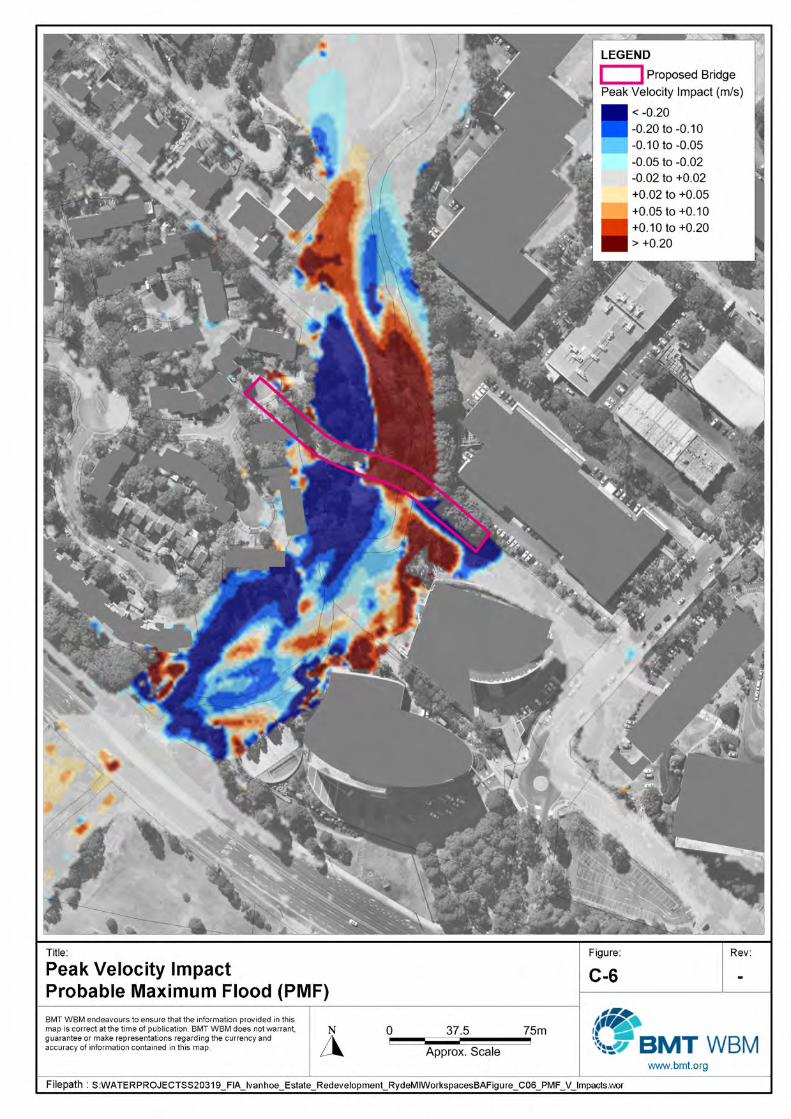
4.2.1 Flood Impact Assessment Model results representing the proposed Shrimptons Creek bridge have been used to assess relative flood impacts associated with the construction of the bridge.
Flood impact mapping is presented for peak water level and peak velocity for all design events considered. These maps show the difference between modelled flood conditions from construction of the bridge and the existing baseline flood conditions. They are useful for presenting the magnitude and extent of flood impacts expected. Peak water level afflux maps and peak velocity impact maps are presented in Appendix C for all design events considered.
The proposed new approach road embankment/abutment on the left and right bank encroaches further into the Shrimptons Creek floodway comparing to existing conditions. Additionally, it is raised higher above the floodplain. The proposed new bridge will not result in any re-distribution of flow between the channel and the floodplain, rather it will result in a localised concentration of flow between the now reduced cross-sectional area of the Shrimptons Creek channel.
Under the proposed scenario, the peak flood levels upstream of the Shrimptons Creek Bridge are expected to increase by up to 0.30 m during the 1% AEP event. The peak flood level increase is localised to the left-hand abutment, with the majority of flood impacts in the order of 0.02 m – 0.10 m in magnitude. Impacts are contained to Shrimptons Creek, propagating upstream 150 m to the Epping Road underpass. The scale of water level impacts modelled is due primarily to the left-hand embankment obstructing conveyance across the floodplain, with minor influences due to the modelled bridge piers.
At the PMF event, the impacts are extensive, however do not propagate any further than the Epping Road underpass. The peak flood level increase in in the order of +0.30 m upstream of the proposed bridge.
Corresponding reductions in flood level in all modelled design events are localised to the Shrimptons Creek Bridge structure, and do not propagate any further downstream.
For the 5% AEP, 1% AEP and PMF events, modelled peak velocities increase in the order of 0.2 m/s across most of the bridge section. At the left abutment, velocities increase by approximately 0.5 - 0.9 m/s. For the PMF event, the velocity across the channel are increased by up to 1.25 m/s and are decreased upstream and downstream of the left abutment.

Shrimptons Creek Bridge Hydrologic and Hydraulic Assessment 10 Assessment of the Proposed Shrimptons Creek Bridge
S:\WATER\PROJECTS\S20319_FIA_Ivanhoe_Estate_Redevelopment_Ryde\Docs\Report\L.S20319.005.01.Shrimptons Creek Bridge Assessment.docx
Figure 4-1 Result Inspection Locations

Shrimptons Creek Bridge Hydrologic and Hydraulic Assessment 11
S:\WATER\PROJECTS\S20319_FIA_Ivanhoe_Estate_Redevelopment_Ryde\Docs\Report\L.S20319.005.01.Shrimptons Creek Bridge Assessment.docx
In terms of overall peak velocities, the velocities in the channel approaching the bridge typically decrease due to the bridge obstruction. This is countered by increases in velocities at the bridge structure and in particular local to the left-hand abutment. However, velocity increases are relatively minor, and do not exceed 0.20 m/s in the main section of channel for the 5% AEP and 1% AEP storm event. The overall risk of erosional damage to Shrimptons Creek during flood events is therefore similar in both the existing and post-works conditions.
Although there are some significant affluxes being modelled, they are largely contained within the channel of Shrimptons Creek. Properties upstream and downstream of the proposed bridge are not impacted by the changes in peak flood level or velocity.

Shrimptons Creek Bridge Hydrologic and Hydraulic Assessment 12 Conclusion
S:\WATER\PROJECTS\S20319_FIA_Ivanhoe_Estate_Redevelopment_Ryde\Docs\Report\L.S20319.005.01.Shrimptons Creek Bridge Assessment.docx
5 Conclusion
The hydrologic and hydraulic assessment undertaken for the proposed Shrimptons Creek bridge has sought to provide an understanding of the existing flood behaviour in and around the proposed bridge location.
Flood behaviour at the site was defined through the application of a TUFLOW hydraulic model. The TUFLOW model was based on the model refined by BMT WBM in the Flood Impact Assessment for Ivanhoe Estate Master Plan (2017).
The developed models were used to simulate the following scenarios:
• Existing Scenario – current flood conditions,
• Proposed Scenario – future flood conditions following the construction of the proposed Shrimptons Bridge.
Output from the TUFLOW hydraulic model was used to assess any local flood impacts of the construction of the proposed Shrimptons Creek bridge.
The proposed bridge design incorporates abutments on both the left and right banks of Shrimptons Creek. As a result, there is a localised concentration of flow between the now reduced cross-sectional area of the Shrimptons Creek channel. The broader flow distribution further upstream and downstream remain relatively unchanged between simulation of the existing scenario and proposed bridge scenario.
Increases in peak flood levels during the 5% and 1% AEP events and the PMF are contained within the Shrimptons Creek channel between Epping Rd and the proposed bridge location. The abutments to the bridge and the bridge itself do not get overtopped during any design event. The soffit of the bridge deck ranges from 46.318 – 46.731 m AHD, and the peak flood level in the PMF (at the upstream side of the proposed bridge) is 46.50 m AHD.
Velocity increases are relatively minor, and do not exceed 0.20 m/s in the main section of channel for the 5% AEP and 1% AEP storm event. The overall risk of erosional damage to Shrimptons Creek during flood events is therefore similar in both the existing and post-works conditions.
Although there are some significant affluxes being modelled, they are largely contained within the channel of Shrimptons Creek. Properties upstream and downstream of the proposed bridge are not impacted by the changes in peak flood level or velocity.
Key information relating to the existing scenario and the bridge is summarised in Table 5-1.
Table 5-1 Shrimptons Creek Bridge Summary of Key Information
Existing Proposed
Bridge Length N/A 51 m
Bridge Deck Level (m AHD) - Eastern Approach N/A 47.581
Soffit Level (m AHD) - Eastern Approach N/A 46.731

Shrimptons Creek Bridge Hydrologic and Hydraulic Assessment 13 Conclusion
S:\WATER\PROJECTS\S20319_FIA_Ivanhoe_Estate_Redevelopment_Ryde\Docs\Report\L.S20319.005.01.Shrimptons Creek Bridge Assessment.docx
Existing Proposed
Bridge Deck Level (m AHD) - Western Approach N/A 47.168
Soffit Level (m AHD) - Western Approach N/A 46.318
Depth of Superstructure N/A 2000-2200 mm
Number of Piers N/A 8
Pier Width N/A Varied
Number of Spans N/A 5
5% AEP Flood Level (m AHD)1 44.3 (44.2 – 44.8) 44.3 (44.2 – 44.7)
1% AEP Flood Level (m AHD)1 44.6 (44.4 – 44.9) 44.6 (44.4 – 45.0)
PMF Flood Level (m AHD)1 45.9 (45.8 – 46.1) 46.1 (45.6 – 46.5)
5% AEP Velocity (m/s)2 1.2 (0.2 – 1.9) 1.4 (0.2 – 2.0)
1% AEP Velocity (m/s)2 1.3 (0.3 – 1.9) 1.6 (0.5 – 2.0)
PMF Velocity (m/s)2 2.0 (1.1 – 4.2) 2.4 (0.8 - 3.7)
1 Average value across channel upstream of bridge (range of minimum and maximum value)
2 Average “depth-averaged” value across channel upstream of bridge (range of minimum and maximum value)

Shrimptons Creek Bridge Hydrologic and Hydraulic Assessment 14 References
S:\WATER\PROJECTS\S20319_FIA_Ivanhoe_Estate_Redevelopment_Ryde\Docs\Report\L.S20319.005.01.Shrimptons Creek Bridge Assessment.docx
6 References
BMT WBM, (2017) Flood Impact Assessment for Ivanhoe Estate Redevelopment
CIRIA, (C551, 2002) Manual on Scour at Bridges and other Structures
Engineers Australia, (2001) Australian Rainfall and Runoff
Ettema, R., Nakato, T. and Muste, M. (2010) Estimation of Scour Depth at Bridge Abutments NCHRP 24-20
FHWA NHI, (HEC-18, 2001) Evaluating Scour at Bridges
FHWA NHI, (HEC-23, 2001) Bridge Scour and Stream Instability Countermeasures
QLD TMR, (2013) Bridge Scour Manual
SAI Global, (2004) AS 5100.1-2004 Australian Standard Bridge design Part 1: Scope and general principles

Shrimptons Creek Bridge Hydrologic and Hydraulic Assessment 1 Appendices
S:\WATER\PROJECTS\S20319_FIA_Ivanhoe_Estate_Redevelopment_Ryde\Docs\Report\L.S20319.005.01.Shrimptons Creek Bridge Assessment.docx
Appendix A Existing Condition Peak Flood Results


Shrimptons Creek Bridge Hydrologic and Hydraulic Assessment 2 Appendices
S:\WATER\PROJECTS\S20319_FIA_Ivanhoe_Estate_Redevelopment_Ryde\Docs\Report\L.S20319.005.01.Shrimptons Creek Bridge Assessment.docx
Appendix B Proposed Scenario Peak Flood Results


Shrimptons Creek Bridge Hydrologic and Hydraulic Assessment 3 Appendices
S:\WATER\PROJECTS\S20319_FIA_Ivanhoe_Estate_Redevelopment_Ryde\Docs\Report\L.S20319.005.01.Shrimptons Creek Bridge Assessment.docx
Appendix C Afflux Mapping


Brisbane Level 8, 200 Creek Street, Brisbane QLD 4000 PO Box 203, Spring Hill QLD 4004 Tel +61 7 3831 6744 Fax +61 7 3832 3627 Email [email protected] Web www.bmt.org
Denver 8200 S. Akron Street, #B120 Centennial, Denver Colorado 80112 USA Tel +1 303 792 9814 Fax +1 303 792 9742 Email [email protected] Web www.bmt.org
London International House, 1st Floor St Katharine’s Way, London E1W 1UN Tel +44 20 8090 1566 Fax +44 20 8943 5347 Email [email protected] Web www.bmt.org
Melbourne Level 5, 99 King Street, Melbourne 3000 Tel +61 3 8620 6100 Fax +61 3 8620 6105 Email [email protected] Web www.bmt.org
Newcastle 126 Belford Street, Broadmeadow 2292 PO Box 266, Broadmeadow NSW 2292 Tel +61 2 4940 8882 Fax +61 2 4940 8887 Email [email protected] Web www.bmt.org
Northern Rivers 6/20 Byron Street, Bangalow 2479 Tel +61 2 6687 0466 Fax +61 2 66870422 Email [email protected] Web www.bmt.org
Perth Level 4, 20 Parkland Road, Osborne, WA 6017 PO Box 2305, Churchlands, WA 6918 Tel +61 8 6163 4900 Email [email protected] Web www.bmt.org
Sydney Suite G2, 13-15 Smail Street, Ultimo, Sydney, NSW, 2007 PO Box 1181, Broadway NSW 2007 Tel +61 2 8987 2900 Fax +61 2 8987 2999 Email [email protected] Web www.bmt.org
Vancouver Suite 401, 611 Alexander Street Vancouver, British Columbia V6A 1E1 Canada Tel +1 604 683 5777 Fax +1 604 608 3232 Email [email protected] Web www.bmt.org